Hail Map in Minnesota on June 2, 2025
The weather event in Minnesota on June 2, 2025 includes Hail, Wind, and Tornado maps. 13 states and 665 cities were impacted and suffered possible damage. The total estimated number of properties impacted is 8,225.
Want more than just the map?
Turn this storm into a full workflow.
- Owner + property data so you know who to knock
- OnDemand branded weather history reports to win the "did we even have hail?" argument
- RoofTrace estimate so reps stop guessing numbers at the door
Bought this map? Upgrade within 7 days and we'll credit the $230. (10-15 min setup call)
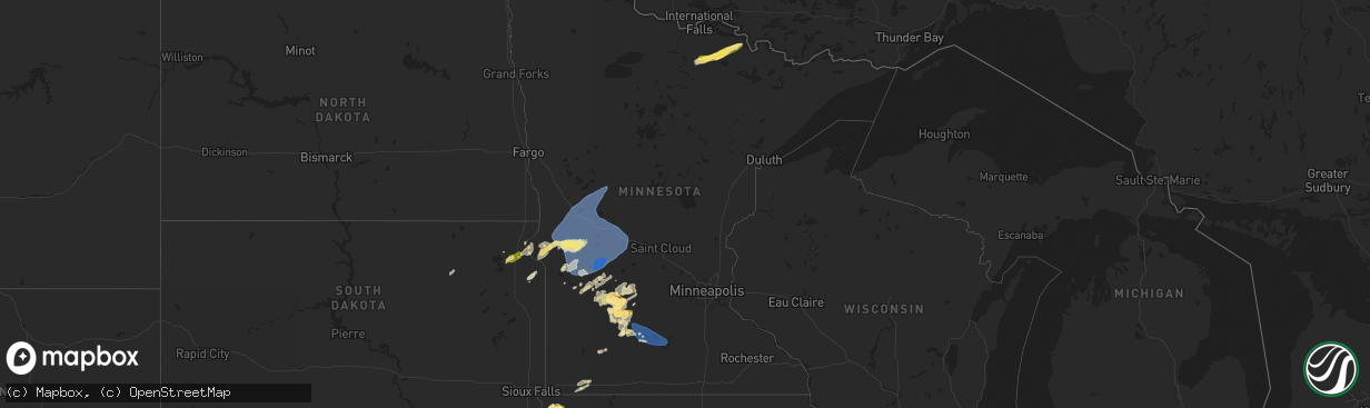
Hail
Wind
Tornado
8,225
Estimated number of impacted properties by a 1.00" hail or larger2,578
Estimated number of impacted properties by a 1.75" hail or larger0
Estimated number of impacted properties by a 2.50" hail or largerStorm reports in Minnesota
Minnesota
| Date | Description |
|---|---|
| 06/02/20256:35 PM CDT | Awos station kulm new ulm ap. |
| 06/02/20256:34 PM CDT | A dead... 2 foot diameter tree downed along 5th north street. Time estimated from radar. |
| 06/02/20256:34 PM CDT | Several large trees snapped at their base in german park. Time estimated from radar. |
| 06/02/20256:33 PM CDT | Several downed trees near the new ulm medical center. Time estimated from radar. |
| 06/02/20256:32 PM CDT | Delayed report from brown county spotters social media. Large tree branch down in sleepy eye mn... Time estimated from radar. |
| 06/02/20256:25 PM CDT | Tin roofing removed from a shed. Time estimated based on radar. |
| 06/02/20255:41 PM CDT | Image of powerlines down... Confirmed by county officials on hwy 5 south of bird island. |
| 06/02/20255:41 PM CDT | A few birch trees were downed from southwest to northeast and on the shoulder of us2. |
| 06/02/20255:35 PM CDT | Delayed report... Time estimated from radar. Lots of nickel to quarter size hail. |
| 06/02/20255:16 PM CDT | Delayed report... Time estimated from radar. Powerlines down 4 north of cosmos. |
| 06/02/20255:12 PM CDT | A local report indicates 1.25 inch wind near 1 ENE Olivia |
| 06/02/20255:11 PM CDT | Delayed report... Time estimated from radar. Half dollar sized hail near cr11 north of olivia. |
| 06/02/20255:08 PM CDT | Delayed report... Time estimated from radar of a few trees down and a semi flipped over on hwy 71 just north of olivia... Mn. |
| 06/02/20255:01 PM CDT | Delayed report... Time estimated from radar. Trees down on a property west of lake elizabeth. |
| 06/02/20255:00 PM CDT | Delayed report... Time estimated from radar. Photo of several downed power lines near roseland shared via x. |
| 06/02/20254:59 PM CDT | Report of damage to a metal outbuilding. |
| 06/02/20252:45 PM CDT | Wind gust estimated 55 to 60 mph... Scouring dirt from the fields creating near zero visibility for a brief time. |
| 06/02/20252:40 PM CDT | Measured by mndot rwis along hwy 9. |
| 06/02/20252:35 PM CDT | Several trees down... Including one on a trailer. Time estimated based on radar. |
| 06/02/20252:30 PM CDT | Several trees down... Including one on a farm building. Time estimated based on radar. |
| 06/02/20252:30 PM CDT | Trees and power lines reported down in glenwood. Time estimated based on radar. |
| 06/02/20252:30 PM CDT | Measured at alexandria airport. |
| 06/02/20252:25 PM CDT | Boat lifts and canopies overturned on lake reno. Time estimated based on radar. |
| 06/02/20252:20 PM CDT | Trees and power lines reported down in starbuck. Time estimated based on radar. |
| 06/02/20252:13 PM CDT | 61 mph gust measured with personal weather station. |
| 06/02/20252:10 PM CDT | A local report indicates 60 MPH wind near Barrett |
| 06/02/20251:55 PM CDT | Ten to 16 inch diameter trees and various limbs snapped off at a residence north of morris along hwy 59. Time estimated based on radar. |
| 06/02/20251:50 PM CDT | Two power poles snapped along highway 9. Young corn stalks were also damaged. Time estimated based on radar. Damage to more power poles... Trees and some outbuildings c |
| 06/02/20251:47 PM CDT | Ndawn observation site. |
| 06/02/20251:46 PM CDT | Ndawn observation. |
All States Impacted by Hail Map on June 2, 2025
Cities Impacted by Hail Map on June 2, 2025
- Goree, TX
- Tampa, FL
- Gibsonton, FL
- Riverview, FL
- Brandon, FL
- Boca Grande, FL
- Seffner, FL
- Dimmitt, TX
- Adrian, TX
- Vega, TX
- Brentford, SD
- Immokalee, FL
- Mellette, SD
- Conde, SD
- Stratford, SD
- Miami, FL
- Opa Locka, FL
- Hollywood, FL
- Ortley, SD
- Hialeah, FL
- Peever, SD
- Grenville, SD
- Summit, SD
- Wilmot, SD
- Aguilar, CO
- Fort Lauderdale, FL
- Walsenburg, CO
- Bovina, TX
- Milbank, SD
- Beardsley, MN
- Ortonville, MN
- Clinton, MN
- Stockholm, SD
- Ochopee, FL
- Miami Gardens, FL
- Browns Valley, MN
- Quemado, NM
- Friona, TX
- Dumont, MN
- Graceville, MN
- Twin Brooks, SD
- Barry, MN
- Pompano Beach, FL
- Appleton, MN
- Chokio, MN
- Key Biscayne, FL
- Hereford, TX
- Boca Raton, FL
- Deerfield Beach, FL
- Morris, MN
- Hancock, MN
- Cyrus, MN
- Alberta, MN
- Holloway, MN
- Donnelly, MN
- Herman, MN
- Barrett, MN
- Norcross, MN
- Elbow Lake, MN
- Ashby, MN
- Evansville, MN
- Danvers, MN
- Delray Beach, FL
- Benson, MN
- Clontarf, MN
- Kensington, MN
- Starbuck, MN
- Hoffman, MN
- Garfield, MN
- Brandon, MN
- Farwell, MN
- Alexandria, MN
- Dalton, MN
- Battle Lake, MN
- Glenwood, MN
- Lowry, MN
- Villard, MN
- Carlos, MN
- Clitherall, MN
- Parkers Prairie, MN
- Miltona, MN
- Vining, MN
- Texico, NM
- Broadview, NM
- Clovis, NM
- Cannon Afb, NM
- Portales, NM
- Nelson, MN
- Osakis, MN
- Murdock, MN
- Brooten, MN
- Sunburg, MN
- Pennock, MN
- Belgrade, MN
- Sauk Centre, MN
- New London, MN
- Henning, MN
- Elrosa, MN
- Melrose, MN
- Deer Creek, MN
- Wadena, MN
- Hewitt, MN
- West Union, MN
- Happy, TX
- Canyon, TX
- Dalhart, TX
- Channing, TX
- Hartley, TX
- Augusta, AR
- Balmorhea, TX
- Laguna, NM
- Tulia, TX
- Silverton, TX
- Amarillo, TX
- Kress, TX
- Montevideo, MN
- Madison, MN
- Albuquerque, NM
- Clewiston, FL
- Bosque Farms, NM
- Maynard, MN
- Watson, MN
- Alcester, SD
- Lubbock, TX
- Idalou, TX
- Petersburg, TX
- Abernathy, TX
- New Deal, TX
- Hale Center, TX
- Wayside, TX
- Claude, TX
- Fritch, TX
- Panhandle, TX
- Stratford, TX
- Groom, TX
- Floydada, TX
- Clara City, MN
- Hudson, SD
- Kerkhoven, MN
- Plainview, TX
- Nazareth, TX
- Clarendon, TX
- Quitaque, TX
- Van Tassell, WY
- Hawarden, IA
- Rock Valley, IA
- Raymond, MN
- Lovington, NM
- Palm City, FL
- Indiantown, FL
- Tokio, TX
- Sioux Center, IA
- Rolla, KS
- Meadow, TX
- Castle Rock, CO
- Guymon, OK
- Franktown, CO
- Stinnett, TX
- White Deer, TX
- Pampa, TX
- Skellytown, TX
- Borger, TX
- Willmar, MN
- Fairview, SD
- Hugoton, KS
- Richfield, KS
- Texhoma, OK
- Keyes, OK
- Boise City, OK
- Lockney, TX
- Slaton, TX
- Ransom Canyon, TX
- Fort Stockton, TX
- Hector, MN
- Sacred Heart, MN
- Big Falls, MN
- Glendo, WY
- Renville, MN
- Cheyenne, WY
- Inwood, IA
- Doon, IA
- Granite Falls, MN
- Spicer, MN
- Prinsburg, MN
- Danube, MN
- Blomkest, MN
- Littlefork, MN
- Gruver, TX
- Spearman, TX
- Lake Lillian, MN
- Estancia, NM
- Broken Bow, NE
- Hardesty, OK
- Belen, NM
- Taylor, NE
- Burwell, NE
- Westbrook, MN
- Alvord, IA
- Mountainair, NM
- Anselmo, NE
- Johnson, KS
- Vermillion, SD
- Rock Rapids, IA
- Atwater, MN
- Wynot, NE
- Mclean, TX
- Perryton, TX
- Miami, TX
- Orr, MN
- Olivia, MN
- Manter, KS
- Grove City, MN
- Bird Island, MN
- Wheatland, WY
- Guernsey, WY
- Hartville, WY
- Newcastle, NE
- Ulysses, KS
- Rushmore, MN
- Kandiyohi, MN
- Cosmos, MN
- Lamberton, MN
- Storden, MN
- Burbank, SD
- Elk Point, SD
- George, IA
- Yoder, WY
- Fort Laramie, WY
- Jay Em, WY
- Orchard, NE
- Hooker, OK
- Moriarty, NM
- Sargent, NE
- Ewing, NE
- Chambers, NE
- Brady, NE
- Maxwell, NE
- Callaway, NE
- Litchfield, MN
- Redwood Falls, MN
- Hull, IA
- Tribune, KS
- Levelland, TX
- Ireton, IA
- Pecos, TX
- Worthington, MN
- Reading, MN
- Kendall, KS
- Lingle, WY
- Crane Lake, MN
- Morton, MN
- Franklin, MN
- Liberal, KS
- Tyrone, OK
- Burns, WY
- Brewster, MN
- Arnold, NE
- Hershey, NE
- Royal, NE
- Brunswick, NE
- Imperial, TX
- Satanta, KS
- Fairfax, MN
- Elbert, CO
- Plainview, NE
- Buffalo Lake, MN
- North Platte, NE
- Hollis, OK
- Merna, NE
- Carpenter, WY
- Clearwater, NE
- Lakin, KS
- Stapleton, NE
- Ropesville, TX
- Boyden, IA
- Orange City, IA
- Torrington, WY
- Kismet, KS
- Plains, KS
- Meade, KS
- Garden City, KS
- Holcomb, KS
- Morgan, MN
- Gould, OK
- Sleepy Eye, MN
- Pine Bluffs, WY
- Hospers, IA
- Sheldon, IA
- Ribera, NM
- Duke, OK
- Wolfforth, TX
- Smyer, TX
- Shallowater, TX
- Ponca, NE
- Lorenzo, TX
- Mobeetie, TX
- Canadian, TX
- Briscoe, TX
- Sheridan Lake, CO
- Mangum, OK
- Beaver, OK
- Vinson, OK
- Deerfield, KS
- Neligh, NE
- Veguita, NM
- Leoti, KS
- Balko, OK
- Lipscomb, TX
- Higgins, TX
- Booker, TX
- Laverne, OK
- Darrouzett, TX
- Follett, TX
- Gothenburg, NE
- Bushnell, NE
- Dixon, NE
- Gate, OK
- Winona, KS
- Jefferson, SD
- New Ulm, MN
- Gibbon, MN
- Winthrop, MN
- Lafayette, MN
- Lake Crystal, MN
- Courtland, MN
- Mankato, MN
- Nicollet, MN
- Saint Peter, MN
- Archer, IA
- Willow, OK
- Briggsdale, CO
- Tahoka, TX
- Weskan, KS
- Sayre, OK
- Fowler, KS
- Granite, OK
- Sharon Springs, KS
- Erick, OK
- Burlington, CO
- Yeso, NM
- Ansley, NE
- Westerville, NE
- Waterbury, NE
- Allen, NE
- Roswell, NM
- Rosston, OK
- Carter, OK
- Wallace, KS
- Edson, KS
- Goodland, KS
- Kanorado, KS
- Dill City, OK
- Sentinel, OK
- Cheyenne, OK
- Jackson, NE
- Ashland, KS
- Oakley, KS
- Oneill, NE
- Brewster, KS
- Emerson, NE
- Hubbard, NE
- Grinnell, KS
- Gove, KS
- Canute, OK
- Socorro, NM
- Hammon, OK
- Willard, NM
- Grant, NE
- New Raymer, CO
- Alamo, NV
- Leedey, OK
- Englewood, KS
- Forgan, OK
- Grainfield, KS
- Reydon, OK
- Sharon, OK
- Lynch, NE
- Fort Sumner, NM
- Wilson, TX
- Grover, CO
- Oconto, NE
- Madrid, NE
- Saint Francis, KS
- Foss, OK
- Mason City, NE
- Elsie, NE
- Wellfleet, NE
- Stoneham, CO
- Clinton, OK
- Venango, NE
- Mutual, OK
- Mooreland, OK
- Comstock, NE
- Park, KS
- Scotland, SD
- Vici, OK
- Arapaho, OK
- Las Vegas, NM
- Encino, NM
- Litchfield, NE
- Bessie, OK
- Corn, OK
- Merino, CO
- Taiban, NM
- Utica, KS
- Quinter, KS
- Waynoka, OK
- Ord, NE
- Ransom, KS
- Adrian, MN
- Chester, OK
- Weatherford, OK
- Imperial, NE
- Sweetwater, OK
- Hurley, SD
- Davis, SD
- Camargo, OK
- Taloga, OK
- Seiling, OK
- Alva, OK
- Hardtner, KS
- Ellis, KS
- Bigelow, MN
- Sterling, CO
- Arcadia, NE
- Loup City, NE
- Benkelman, NE
- Thomas, OK
- Custer City, OK
- Dodson, TX
- Brownell, KS
- Kiowa, KS
- Hazelton, KS
- Burlington, OK
- Fairview, OK
- Atwood, CO
- Elk City, OK
- Butler, OK
- Champion, NE
- Lenora, KS
- Haigler, NE
- Wallace, NE
- Wauneta, NE
- Aline, OK
- McDonald, KS
- Bird City, KS
- Stratton, NE
- Max, NE
- Palisade, NE
- Dodge City, KS
- Minneola, KS
- Wright, KS
- Ensign, KS
- Spearville, KS
- Montezuma, KS
- Ford, KS
- Peetz, CO
- Watonga, OK
- Wray, CO
- Snyder, CO
- Brush, CO
- Lexington, NE
- Cozad, NE
- Carmen, OK
- Dacoma, OK
- Fay, OK
- Dickens, NE
- Arnett, OK
- Cherokee, OK
- Fleming, CO
- Akron, CO
- Farnam, NE
- Eustis, NE
- Wellington, TX
- Moorefield, NE
- Stockville, NE
- Sidney, NE
- Canton, OK
- Miller, NE
- Amorita, OK
- Hayes Center, NE
- Maywood, NE
- Almena, KS
- Long Island, KS
- Curtis, NE
- Stamford, NE
- Eddyville, NE
- Elwood, NE
- Hitchcock, OK
- Okeene, OK
- Helena, OK
- Bertrand, NE
- Hazard, NE
- Loomis, NE
- Grandfalls, TX
- Cordell, OK
- Overton, NE
- Sumner, NE
- Orleans, NE
- Pleasanton, NE
- Beresford, SD
- Gail, TX
- Jet, OK
- Kingfisher, OK
- Crane, TX
- Elm Creek, NE
- Nash, OK
- Holdrege, NE
- Bloomington, NE
- Ames, OK
- Hennessey, OK
- Geary, OK
- Amherst, NE
- Kearney, NE
- Minden, NE
- Riverdale, NE
- Brule, NE
- Oakwood, OK
- Odessa, NE
- Franklin, NE
- Hildreth, NE
- Upland, NE
- Ravenna, NE
- Waukomis, OK
- Riverton, NE
- Cleo Springs, OK
- Longdale, OK
- Southard, OK
- Kenesaw, NE
- Shelton, NE
- Gibbon, NE
- Justiceburg, TX
- Odessa, TX
- Douglas, OK
- Greenfield, OK
- McCamey, TX
- Wood River, NE
- Midkiff, TX
- Doniphan, NE
- Enochs, TX
- Colony, OK
- Fairmont, OK
- Grand Island, NE
- Omega, OK
- Morton, TX
- Sudan, TX
- Cairo, NE
- Alda, NE
- Saint Paul, NE
- Palmer, NE
- Sutton, NE
- Midland, TX
- Edgar, NE
- Chapman, NE
- Marquette, NE
- Aurora, NE
- Saint Libory, NE
- Central City, NE
- Leonardville, KS
- Riley, KS
- Palmer, KS
- Linn, KS
- Green, KS
- Archer, NE
- Hydro, OK
- Hinton, OK
- Saint George, KS
- Westmoreland, KS
- Barnes, KS
- Loyal, OK
- Western, NE
- Dover, OK
- Odell, NE
- Clatonia, NE
- Garden City, TX
- Dorchester, NE
- Crete, NE
- Wilber, NE
- Lamesa, TX
- Ackerly, TX
- Stromsburg, NE
- Clarks, NE
- Beatrice, NE
- Greenleaf, KS
- Steele City, NE
- Brownfield, TX
- Diller, NE
- Wymore, NE
- Osceola, NE
- Silver Creek, NE
- Benedict, NE
- Seminole, TX
- Hallam, NE
- Cortland, NE
- Beattie, KS
- Blue Springs, NE
- Odonnell, TX
- Kermit, TX
- Burchard, NE
- Sprague, NE
- Roca, NE
- Martell, NE
- Post, TX
- Paxico, KS
- Fluvanna, TX
- Corning, KS
- Schuyler, NE
- Columbus, NE
- Steinauer, NE
- Tecumseh, NE
- Lewiston, NE
- Eskridge, KS
- Harveyville, KS
- Goldsmith, TX
- Maple Hill, KS
- Pawnee City, NE
- Goff, KS
- Oxford, NE
- Wilcox, NE
- Heartwell, NE
- Atlanta, NE
- Roseland, NE
- Holstein, NE
- Alma, NE
- Juniata, NE
- Axtell, NE
- Funk, NE
- Topeka, KS
- Gardendale, TX
- North Bend, NE
- Andrews, TX
- Ames, NE
- Hooper, NE
- Stanton, TX
- Muscotah, KS
- Louisville, NE
- Rulo, NE
- Crawford, OK
- Durham, OK
- Springfield, NE
- Buffalo, OK
- Medicine Lodge, KS
- Wilmore, KS
- Isabel, KS
- Protection, KS
- Nashville, KS
- Coldwater, KS
- Big Lake, TX
- Zenda, KS
- Spivey, KS
- Kingman, KS
- Exira, IA
- Brayton, IA
- Dryden, TX
- Murdock, KS
- Milton, KS
- Barnhart, TX
- Clearwater, KS
- Viola, KS
- Ozona, TX
- Conway Springs, KS
- Whitewater, KS
- Potwin, KS
- Comstock, TX
- Madison, KS


