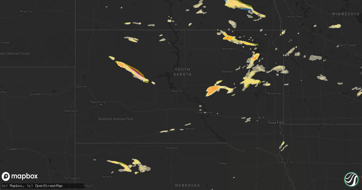
Hail Map in South Dakota on June 2, 2024
Get this storm
June 2 map
$229
one time, instant access
Download today. No call, no setup
Keep the $229
Bought the map and want the full workflow? Apply the entire $229 to a subscription within 7 days. None of it is wasted.
Every map, not just this one
This buys you this map. Subscription and you get every map we run, in the markets you choose from a few cities to whole states to nationwide. Plus real-time alerts the moment a storm fires.
Contact data
Name, contact info, occupancy, even credit band for addresses in the footprint. You go from where it hit to who to call.
Become the source they trust
Unlimited branding weather history reports on demand. You already have the documented answer ready for the property owner, and you are the one who showed up with it.
Property data and RoofTrace estimates
Pull up any address you have got, its value and the exact code rules for that jurisdiction, straight from One Click Code. Then RoofTrace estimates the squares, pitch, and roof value, priced the way you price.
Storm reports in South Dakota
South Dakota
| Date | Description |
|---|---|
| 06/02/20246:50 PM CDT | A local report indicates 1.75 inch wind near 4 W Sand Lake Wildlife |
| 06/02/20246:45 PM CDT | Report from mping: baseball |
| 06/02/20246:45 PM CDT | A local report indicates 1.25 inch wind near 2 W Willow Lake |
| 06/02/20246:30 PM CDT | A local report indicates 1.00 inch wind near 7 SE Clark |
| 06/02/20246:30 PM CDT | A local report indicates 1.25 inch wind near 1 N Barnard |
| 06/02/20246:21 PM CDT | Em reports golfball to baseball hail. |
| 06/02/20246:16 PM CDT | A local report indicates 2.75 inch wind near Miller Dale Colony |
| 06/02/20246:11 PM CDT | A local report indicates 2.75 inch wind near 2 S Miller Dale Colony |
| 06/02/20245:57 PM CDT | A local report indicates 1.25 inch wind near 5.5 W Barnard |
| 06/02/20245:45 PM CDT | A few quarter size hail stones. |
| 06/02/20245:16 PM CDT | A local report indicates 1.00 inch wind near 1 WNW Red Scaffold |
| 06/02/20244:20 PM CDT | A local report indicates 1.75 inch wind near 12 NE Opal |
| 06/02/20244:16 PM CDT | Meade county sheriff's office confirms a tornado crossed highway 212 around mm 100... 14 miles west of faith. |
| 06/02/20244:16 PM CDT | Meade county sheriff's office confirms a tornado crossed highway 212 around mm 97... 17 miles west of faith. |
| 06/02/20244:12 PM CDT | A local report indicates 2.50 inch wind near 17 SW Usta |
| 06/02/20243:30 PM CDT | A local report indicates 1.00 inch wind near 2 W Rapid City Arpt |
| 06/02/20248:58 AM CDT | Time estimated by radar. |
| 06/01/202411:47 PM CDT | A local report indicates 1.00 inch wind near 4 S Revillo |
| 06/01/202410:45 PM CDT | Corrects previous non-tstm wnd gst report from 4 w waubay. Mesonet station 182 waubay |
| 06/01/20249:51 PM CDT | Asos station kabr aberdeen rgnl ap. |
| 06/01/20249:51 PM CDT | Estimated 50-60 mph winds. Small hail and 4.30 inches of rain. |
| 06/01/20249:07 PM CDT | Quarter size hail 2 miles south of lake poinsett. |
| 06/01/20248:58 PM CDT | Time estimated. |
| 06/01/20248:56 PM CDT | Campers tipped over. Relayed through emergency manager. Time estimated. |
| 06/01/20248:46 PM CDT | Hail slightly larger than quarter-sized. |
| 06/01/20248:17 PM CDT | Relayed via slack pictures. Size estimated. |
| 06/01/20248:15 PM CDT | Hail up to the size of quarters for a brief time. |
| 06/01/20248:01 PM CDT | A local report indicates 64 MPH wind near 4 SSE Witten |
| 06/01/20247:59 PM CDT | Report from mping: quarter |
| 06/01/20247:50 PM CDT | A local report indicates 1.00 inch wind near 2 SSE Claremont |
| 06/01/20247:13 PM CDT | Photo on facebook of hail from golf ball to baseball size. |
| 06/01/20247:06 PM CDT | Lasted for a couple minutes. |
| 06/01/20247:02 PM CDT | Quarter sized hail and 0.95 inch of rain. |
All States Impacted by Hail Map on June 2, 2024
Cities Impacted by Hail Map on June 2, 2024
- Moorefield, NE
- Shamrock, TX
- Pampa, TX
- Mclean, TX
- Eustis, NE
- Papillion, NE
- Farnam, NE
- Pingree, ND
- Norton, KS
- Elwood, NE
- Offutt Afb, NE
- Bellevue, NE
- Wellington, TX
- Wilsonville, NE
- Hendley, NE
- Council Bluffs, IA
- Cambridge, NE
- Chillicothe, TX
- Eldorado, OK
- Beaver City, NE
- Holbrook, NE
- Arapahoe, NE
- Vernon, TX
- Dodson, TX
- Hollis, OK
- Edison, NE
- Hartland, MN
- Albert Lea, MN
- Long Island, KS
- Oxford, NE
- Gould, OK
- Duke, OK
- Mangum, OK
- Orleans, NE
- Cimarron, KS
- Odell, TX
- Phillipsburg, KS
- Prairie View, KS
- Stamford, NE
- Olustee, OK
- Holdrege, NE
- Atlanta, NE
- Dodge City, KS
- Altus, OK
- Elmer, OK
- Electra, TX
- Blair, OK
- Cleveland, ND
- Harrold, TX
- Medina, ND
- Frederick, OK
- Pierre Part, LA
- Morgan City, LA
- Napoleonville, LA
- Altus Afb, OK
- Iowa Park, TX
- Burkburnett, TX
- Davidson, OK
- Oklaunion, TX
- Spearville, KS
- Loveland, OK
- Arnaudville, LA
- Wichita Falls, TX
- Thibodaux, LA
- Gibson, LA
- Grandfield, OK
- Hollister, OK
- Walters, OK
- Devol, OK
- Schriever, LA
- Donner, LA
- Saint Martinville, LA
- Chattanooga, OK
- Breaux Bridge, LA
- Lawton, OK
- Faxon, OK
- Theriot, LA
- Indiahoma, OK
- Snyder, OK
- Cache, OK
- Medicine Park, OK
- Elba, NE
- Chickasha, OK
- Loreauville, LA
- Jeanerette, LA
- New Iberia, LA
- Cement, OK
- Anadarko, OK
- Fletcher, OK
- Paducah, TX
- Wing, ND
- Temple, OK
- Tuttle, ND
- Petrolia, TX
- Ninnekah, OK
- Verden, OK
- Geronimo, OK
- Waurika, OK
- Sheppard Afb, TX
- Comanche, OK
- Duncan, OK
- Chaseley, ND
- Seymour, TX
- Oklahoma City, OK
- Yukon, OK
- Robinson, ND
- Hurdsfield, ND
- Bowdon, ND
- Edmond, OK
- Walden, CO
- Bethany, OK
- Hastings, OK
- Randlett, OK
- Benjamin, TX
- Dunseith, ND
- Byers, TX
- Knox City, TX
- Munday, TX
- Ryan, OK
- Ringling, OK
- Loco, OK
- New Rockford, ND
- Old Glory, TX
- Mylo, ND
- Henrietta, TX
- Holliday, TX
- Saint John, ND
- Goree, TX
- O'Brien, TX
- Elmore City, OK
- Sheyenne, ND
- Kaplan, LA
- Hennepin, OK
- Ratliff City, OK
- Rocklake, ND
- Graham, OK
- Healdton, OK
- Harrisburg, NE
- Leeds, ND
- Rochester, TX
- Cando, ND
- Springer, OK
- Wilson, OK
- Ardmore, OK
- Davis, OK
- Woodworth, ND
- Weinert, TX
- Terral, OK
- Ringgold, TX
- Throckmorton, TX
- Rule, TX
- Nocona, TX
- Lone Grove, OK
- Mcclusky, ND
- Crawford, NE
- Wishek, ND
- Zeeland, ND
- Hague, ND
- Bellevue, TX
- New England, ND
- Egeland, ND
- Haskell, TX
- Abbeville, LA
- Newcastle, TX
- Bayard, NE
- Langdon, ND
- Munich, ND
- Denhoff, ND
- Olney, TX
- Bowie, TX
- Lindsay, TX
- Saint Jo, TX
- Muenster, TX
- Gainesville, TX
- Goodrich, ND
- Manville, WY
- Dalton, NE
- Bridgeport, NE
- Potter, NE
- Wales, ND
- Prairie City, SD
- Martin, ND
- Montague, TX
- Burneyville, OK
- Leon, OK
- Bushnell, NE
- Las Animas, CO
- Pine Bluffs, WY
- Lusk, WY
- Lehr, ND
- Mud Butte, SD
- Meadow, SD
- Harvey, ND
- Loving, TX
- McLaughlin, SD
- Gering, NE
- Fort Stockton, TX
- Napoleon, ND
- Hay Springs, NE
- Fessenden, ND
- Gurley, NE
- Graham, TX
- Mill Creek, OK
- Tishomingo, OK
- Mott, ND
- New Raymer, CO
- Dickinson, ND
- Jacksboro, TX
- Windthorst, TX
- Forestburg, TX
- Madill, OK
- Gackle, ND
- Sidney, NE
- Whitesboro, TX
- Faith, SD
- Buchanan, ND
- Kenefic, OK
- Ellsworth, NE
- Jermyn, TX
- Bryson, TX
- Padroni, CO
- Krum, TX
- Valley View, TX
- Collinsville, TX
- Gladstone, ND
- Fredonia, ND
- Minnewaukan, ND
- Milburn, OK
- Bingham, NE
- Merriman, NE
- Decatur, TX
- Sanger, TX
- Lemmon, SD
- Tappen, ND
- Saint Peter, MN
- Maddock, ND
- Rushville, NE
- Tioga, TX
- Lodgepole, NE
- Dawson, ND
- Pilot Point, TX
- Le Sueur, MN
- Denton, TX
- Ponder, TX
- Bridgeport, TX
- Devils Lake, ND
- Perrin, TX
- Chico, TX
- Le Center, MN
- Hettinger, ND
- Penn, ND
- Dupree, SD
- Lake Dallas, TX
- Chappell, NE
- Walsh, CO
- Deridder, LA
- Alliance, NE
- Poolville, TX
- Dequincy, LA
- Paradise, TX
- Lewisville, TX
- Argyle, TX
- San Saba, TX
- Sedgwick, CO
- Ovid, CO
- Julesburg, CO
- Pettibone, ND
- Ashby, NE
- Evans, LA
- Goldthwaite, TX
- Rhome, TX
- Little Elm, TX
- Aubrey, TX
- Flower Mound, TX
- Justin, TX
- Frisco, TX
- Keldron, SD
- Montgomery, MN
- Celina, TX
- Holly, CO
- Leesville, LA
- Haslet, TX
- Sterling, CO
- Roanoke, TX
- Iroquois, SD
- Springtown, TX
- Boyd, TX
- Azle, TX
- Longville, LA
- Flagler, CO
- Newark, TX
- The Colony, TX
- Southlake, TX
- Aledo, TX
- Weatherford, TX
- New Prague, MN
- Clear Lake, SD
- Cottonwood, MN
- Fort Worth, TX
- Streeter, ND
- Brinson, GA
- Little Eagle, SD
- Whitman, NE
- Rapid City, SD
- Yale, SD
- Boswell, OK
- Manter, KS
- Syracuse, KS
- Livingston, TX
- Colleyville, TX
- Ragley, LA
- Irving, TX
- Carpenter, SD
- Willow Lake, SD
- Dallas, TX
- Sunray, TX
- Kilkenny, MN
- Waterville, MN
- Jamestown, ND
- Highmore, SD
- Ree Heights, SD
- Happy, TX
- Dublin, TX
- New Leipzig, ND
- Cherry Creek, SD
- Frederick, SD
- Westport, SD
- Faribault, MN
- Dumas, TX
- Haltom City, TX
- North Richland Hills, TX
- Venango, NE
- Cleveland, MN
- Elysian, MN
- Amarillo, TX
- Rice, TX
- Elgin, ND
- Bainbridge, GA
- Canyon, TX
- Midland, SD
- Barnard, SD
- Chatfield, TX
- Miller, SD
- Corsicana, TX
- Kerens, TX
- Saint Lawrence, SD
- Redfield, SD
- Tulare, SD
- Ashton, SD
- Mansfield, SD
- Rockham, SD
- Aberdeen, SD
- Northville, SD
- Huntsville, TX
- Gary, SD
- Marietta, MN
- Holyoke, CO
- Wray, CO
- Ypsilanti, ND
- Canby, MN
- Selfridge, ND
- Imperial, NE
- Linton, ND
- Lower Brule, SD
- Royse City, TX
- Terrell, TX
- Grant, NE
- Quinlan, TX
- Mckinney, TX
- Clark, SD
- Elkhart, KS
- Wessington, SD
- Morgan, TX
- Kopperl, TX
- Nerstrand, MN
- Northfield, MN
- Blum, TX
- Dennison, MN
- Kenyon, MN
- Burleson, TX
- Columbia, SD
- Mansfield, TX
- Corrigan, TX
- Diboll, TX
- Madrid, NE
- Vona, CO
- Kintyre, ND
- Vienna, SD
- Fort Yates, ND
- Wills Point, TX
- Erwin, SD
- Bryant, SD
- Groveton, TX
- Kennard, TX
- Joshua, TX
- Godley, TX
- Crowley, TX
- Powell, TX
- Madison, MN
- Idalia, CO
- Zavalla, TX
- Watertown, SD
- Buffalo, TX
- Allen, TX
- Kaufman, TX
- Oakwood, TX
- Hecla, SD
- Hayes, SD
- Houghton, SD
- Panhandle, TX
- Montpelier, ND
- Bird City, KS
- Stratton, CO
- Stinnett, TX
- Henry, SD
- Fairfield, TX
- Lufkin, TX
- Champion, NE
- Marion, ND
- Elsie, NE
- Hayes Center, NE
- Wauneta, NE
- Burlington, CO
- Apple Springs, TX
- Saint Francis, KS
- Florence, SD
- Stratton, NE
- Mabank, TX
- Kemp, TX
- Emory, TX
- Madison Lake, MN
- Trinidad, TX
- Dryden, TX
- Litchville, ND
- Dickey, ND
- Claremont, SD
- Tennessee Colony, TX
- Palestine, TX
- Trenton, NE
- Webster, SD
- Huntington, TX
- Wayside, TX
- Tulia, TX
- Maywood, NE
- McCook, NE
- Grand Saline, TX
- Alba, TX
- Palisade, NE
- Sutherland, NE
- Claude, TX
- Canton, TX
- Paxton, NE
- Malakoff, TX
- Wallace, SD
- McDonald, KS
- Valentine, NE
- Venus, TX
- Alvarado, TX
- Johnson, KS
- Fritch, TX
- Wellfleet, NE
- Curtis, NE
- Culbertson, NE
- Benkelman, NE
- Saint Francis, SD
- Parmelee, SD
- Mission, SD
- Max, NE
- Waubay, SD
- Montalba, TX
- Mineola, TX
- Miltona, MN
- Carlos, MN
- Parkers Prairie, MN
- Raymond, SD
- Enders, NE
- Stephenville, TX
- Hico, TX
- Cleburne, TX
- Lockney, TX
- Plainview, TX
- Alexandria, MN
- Athens, TX
- Eustace, TX
- Maxwell, NE
- Brady, NE
- Silverton, TX
- Kathryn, ND
- Midlothian, TX
- Sanderson, TX
- Melissa, TX
- Marvin, SD
- Borger, TX
- Lindale, TX
- Chireno, TX
- Etoile, TX
- Ben Wheeler, TX
- Hillsboro, TX
- Itasca, TX
- Lake Norden, SD
- Verona, ND
- Fort Ransom, ND
- Lisbon, ND
- Nome, ND
- Larue, TX
- Winner, SD
- Ortonville, MN
- Odessa, MN
- Goodland, KS
- Nacogdoches, TX
- Avon, MN
- Cold Spring, MN
- Richmond, MN
- Reliance, SD
- Big Sandy, TX
- Hawkins, TX
- Big Stone City, SD
- Rio Vista, TX
- Keene, TX
- Tryon, NE
- North Platte, NE
- Covington, TX
- Tyler, TX
- Chandler, TX
- Pine Island, MN
- New Boston, TX
- Langford, SD
- Enderlin, ND
- Iredell, TX
- Milford, TX
- Fleming, CO
- Haxtun, CO
- Big Springs, NE
- Brule, NE
- Amherst, CO
- Ogallala, NE
- Wallace, NE
- Dickens, NE
- Hershey, NE
- Parks, NE
- Lamoure, ND
- Wolsey, SD
- Garden City, SD
- Fullerton, ND
- Atwood, KS
- Correll, MN
- Chokio, MN
- Strasburg, ND
- Marathon, TX
- Gladewater, TX
- Winona, TX
- Carlton, TX
- Tarzan, TX
- Beardsley, MN
- Clinton, MN
- Wilmot, SD
- Flint, TX
- Fluvanna, TX
- Frankfort, SD
- Gilmer, TX
- Witten, SD
- Ideal, SD
- Breckenridge, TX
- Caddo, TX
- Mingus, TX
- Woodson, TX
- Ranger, TX
- Indianola, NE
- Keystone, NE
- Stapleton, NE
- Cozad, NE
- Callaway, NE
- Gothenburg, NE
- Stockville, NE
- Miami, TX
- Willow Island, NE
- Bartley, NE
- Eddyville, NE
- Mason City, NE
- Broken Bow, NE
- Ansley, NE
- Lexington, NE
- Sumner, NE
- Oconto, NE
- Smithfield, NE
- Overton, NE
- Ellendale, ND
- Anselmo, NE
- Turton, SD
- Doland, SD
- Longview, TX
- Bradley, SD
- Owatonna, MN
- Alberta, MN
- Morris, MN
- White Oak, TX
- Forbes, ND
- Elkhart, TX
- Kilgore, TX
- Whitehouse, TX
- Huron, SD
- Norcatur, KS
- Oberlin, KS
- Lebanon, NE
- Danbury, NE
- Clarendon, TX
- Comstock, TX
- Claremont, MN
- Troup, TX
- Henderson, TX
- Overton, TX
- Roslyn, SD
- Selman City, TX
- Sisseton, SD
- Britton, SD
- Oakes, ND
- Hallsville, TX
- Chamberlain, SD
- Snyder, TX
- Center, TX
- Eden, SD
- Grenville, SD
- Claire City, SD
- Milnor, ND
- Gwinner, ND
- Estelline, SD
- Arlington, SD
- Lidgerwood, ND
- Veblen, SD
- Marshall, TX
- Leola, SD
- Dodge Center, MN
- Wheaton, MN
- Beckville, TX
- Joaquin, TX
- Tenaha, TX
- Donnelly, MN
- Tatum, TX
- Jacksonville, TX
- Alpena, SD
- Zap, ND
- Beulah, ND
- Lenora, KS
- Herndon, KS
- Jennings, KS
- Bertrand, NE
- Miller, NE
- Clayton, KS
- Bruce, SD
- Quitaque, TX
- Jefferson, TX
- Barrett, MN
- Herman, MN
- Burwell, NE
- Comstock, NE
- Kasson, MN
- Long Prairie, MN
- Swanville, MN
- Browerville, MN
- Stirum, ND
- Appleton, MN
- Elm Creek, NE
- Logan, KS
- Hill City, KS
- Loomis, NE
- Almena, KS
- Bogue, KS
- Amherst, NE
- Pleasanton, NE
- Stockton, KS
- Alma, NE
- Grand Island, NE
- Kensington, KS
- Naponee, NE
- Heartwell, NE
- Franklin, NE
- Cairo, NE
- Republican City, NE
- Hazard, NE
- Ravenna, NE
- Litchfield, NE
- Bloomington, NE
- Glade, KS
- Agra, KS
- Boelus, NE
- Upland, NE
- Funk, NE
- Gibbon, NE
- Kenesaw, NE
- Riverdale, NE
- Axtell, NE
- Odessa, NE
- Wood River, NE
- Kearney, NE
- Wilcox, NE
- Hildreth, NE
- Shelton, NE
- Minden, NE
- Rockville, NE
- Arcadia, NE
- Dannebrog, NE
- Loup City, NE
- Ashton, NE
- Arnold, NE
- Westerville, NE
- Merna, NE
- Ord, NE
- North Loup, NE
- Greeley, NE
- Wolbach, NE
- Saint Paul, NE
- Farwell, NE
- Scotia, NE
- Turkey, TX
- Childress, TX
- Oil City, LA
- De Berry, TX
- Randall, MN
- Little Falls, MN
- Ida, LA
- Vivian, LA
- Mantorville, MN
- Holloway, MN
- Wyndmere, ND
- Ennis, TX
- Carthage, TX
- Keatchie, LA
- Logansport, LA
- Gary, TX
- Scurry, TX
- Abbott, TX
- Saint Libory, NE
- Alda, NE
- Halliday, ND
- Hazen, ND
- Byron, MN
- Stonewall, LA
- Grand Cane, LA
- Gloster, LA
- Keithville, LA
- Castlewood, SD
- Bristol, SD
- Mooringsport, LA
- Amherst, SD
- Aquilla, TX
- Whitney, TX
- Palmer, NE
- Chapman, NE
- Archer, NE
- Central City, NE
- Fullerton, NE
- Belgrade, NE
- Groton, SD
- New Salem, ND
- Frierson, LA
- Kimball, SD
- Danvers, MN
- Benson, MN
- Hubbard, TX
- Dawson, TX
- West, TX
- Golden Valley, ND
- Arlington, TX
- Grand Prairie, TX
- Euless, TX
- Hurst, TX
- Meridian, TX
- Barry, TX
- Bedford, TX
- Wylie, TX
- Ewing, NE
- Coolidge, TX
- Alto, TX
- Andover, SD
- Grapevine, TX
- Clearwater, NE
- Murdock, MN
- Rockwall, TX
- Forney, TX
- Sunnyvale, TX
- Garland, TX
- Lavon, TX
- Rowlett, TX
- Mesquite, TX
- Lebanon, KS
- Princeton, TX
- Crandall, TX
- Kerkhoven, MN
- Sunburg, MN
- Ortley, SD
- Conde, SD
- Pennock, MN
- Tintah, MN
- Eads, CO
- Mitchell, SD
- Dundas, MN
- Hendricks, MN
- Willmar, MN
- Elyria, NE
- Burr Oak, KS
- Waco, NE
- Idalou, TX
- Strandburg, SD
- Goodwin, SD
- Ivanhoe, MN
- Arapahoe, CO
- Spicer, MN
- Friend, NE
- Milford, NE
- New London, MN
- Gresham, NE
- Milligan, NE
- Tobias, NE
- Superior, NE
- Mankato, KS
- Beaver Crossing, NE
- Ohiowa, NE
- York, NE
- Van, TX
- Grandview, TX
- Maypearl, TX
- Waxahachie, TX
- Tribune, KS
- Utica, NE
- Labolt, SD
- Revillo, SD
- Hardy, NE
- Dorchester, NE
- Bruning, NE
- Kandiyohi, MN
- Alexandria, SD
- Fulton, SD
- Kingman, KS
- Streetman, TX
- Bynum, TX
- Penelope, TX
- Malone, TX
- Goehner, NE
- Seward, NE
- Spivey, KS
- Sheridan Lake, CO
- Alexandria, NE
- Emery, SD
- Italy, TX
- Pineland, TX
- Salem, SD
- Montrose, SD
- Arp, TX
- Purdon, TX
- Akron, IA
- Canistota, SD
- Bridgewater, SD
- Elk Point, SD
- Norwich, KS
- Richland, TX
- Alcester, SD
- Hawarden, IA
- Leoti, KS
- Rusk, TX
- Cheney, KS
- Wheeler, TX
- Saint Joseph, MN
- Viola, KS
- Milton, KS
- Goddard, KS
- Garden Plain, KS
- Lakin, KS
- Renville, MN
- Galva, KS
- Hitchcock, SD
- Canton, KS
- Olivia, MN
- Redwood Falls, MN
- Danube, MN
- Kendall, KS
- Moundridge, KS
- Newton, KS
- Hillsboro, KS
- Goessel, KS
- Bird Island, MN
- Holcomb, KS
- Wright, KS
- Lehigh, KS
- Marion, KS
- Peabody, KS
- Ulysses, KS
- Edson, KS
- Garden City, KS
- Soper, OK
- Gibbon, MN
- Winthrop, MN
- Hydro, OK
- Binger, OK
- Hugo, OK
- Cassoday, KS
- Durham, KS
- Englewood, KS
- Lookeba, OK
- Montezuma, KS
- Ashland, KS
- Pocasset, OK
- Matfield Green, KS
- Ensign, KS
- Sublette, KS
- Gracemont, OK
- Minco, OK
- Minneola, KS
- Protection, KS
- Copeland, KS
- Fowler, KS
- Amber, OK
- Blanchard, OK
- Ireton, IA
- Choctaw, OK
- Newalla, OK
- Bucklin, KS
- Ford, KS
- Coldwater, KS
- Burns, KS
- Cedar Point, KS
- Hamilton, KS
- Eureka, KS
- Harrah, OK
- Norman, OK
- Wellston, OK
- Luther, OK
- Madison, KS
- Meade, KS
- Mcloud, OK
- Noble, OK
- Mullinville, KS
- Tecumseh, OK
- Virgil, KS
- Spencer, OK
- Pierceville, KS
- Ingalls, KS
- Satanta, KS
- Plains, KS
- Jetmore, KS
- Wilmore, KS
- Haviland, KS
- Greensburg, KS
- Severy, KS
- Shawnee, OK
- Gridley, KS
- Wanette, OK
- Beaver, OK
- Balko, OK
- Coats, KS
- Sun City, KS
- Pratt, KS
- Sawyer, KS
- Asher, OK
- Lake City, KS
- Konawa, OK
- Maud, OK
- Ada, OK
- Toronto, KS
- Macomb, OK
- Yates Center, KS
- Byars, OK
- Arkansas City, KS
- Geuda Springs, KS
- Medicine Lodge, KS
- Hardtner, KS
- Iuka, KS
- Offerle, KS
- Laverne, OK
- Rosston, OK
- Okmulgee, OK
- Independence, KS
- Havana, KS
- Fall River, KS
- Mayfield, KS
- Allen, OK
- Sasakwa, OK
- Shattuck, OK
- Wellington, KS
- Seminole, OK
- Wichita, KS
- Atwood, OK
- Holdenville, OK
- Wewoka, OK
- Cedar Vale, KS
- Moline, KS
- Fargo, OK
- Sedan, KS
- Peck, KS
- Belle Plaine, KS
- Stonewall, OK
- Peru, KS
- Calvin, OK
- Kiowa, KS
- Hazelton, KS
- Sharon, KS
- Isabel, KS
- Rose Hill, KS
- Derby, KS
- Andover, KS
- Howard, KS
- Coffeyville, KS
- Elk Falls, KS
- Valley Center, KS
- Kechi, KS
- Niotaze, KS
- Mulvane, KS
- Gage, OK
- Stockholm, SD
- Kranzburg, SD


