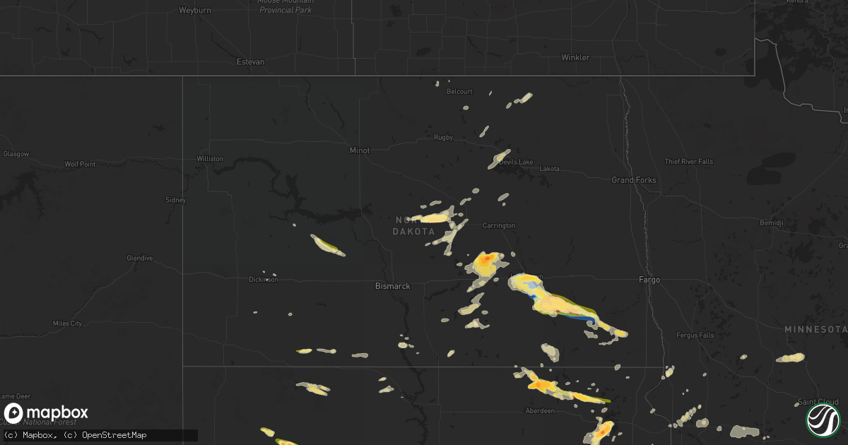
Hail Map in North Dakota on June 2, 2024
Get this storm
June 2 map
$229
one time, instant access
Download today. No call, no setup
Keep the $229
Bought the map and want the full workflow? Apply the entire $229 to a subscription within 7 days. None of it is wasted.
Every map, not just this one
This buys you this map. Subscription and you get every map we run, in the markets you choose from a few cities to whole states to nationwide. Plus real-time alerts the moment a storm fires.
Contact data
Name, contact info, occupancy, even credit band for addresses in the footprint. You go from where it hit to who to call.
Become the source they trust
Unlimited branding weather history reports on demand. You already have the documented answer ready for the property owner, and you are the one who showed up with it.
Property data and RoofTrace estimates
Pull up any address you have got, its value and the exact code rules for that jurisdiction, straight from One Click Code. Then RoofTrace estimates the squares, pitch, and roof value, priced the way you price.
Storm reports in North Dakota
North Dakota
| Date | Description |
|---|---|
| 06/02/20246:30 PM CDT | 1.50 inches of rain fell in about 30 minutes as well. |
| 06/02/20246:00 PM CDT | Reported by spotter visiting downtown jamestown. Also reported strong winds and heavy rain. |
| 06/02/20245:56 PM CDT | Measured wind gust from jamestown ess nddot station. Time estimated from radar. |
| 06/02/20245:51 PM CDT | Relayed through social media. |
| 06/02/20245:03 PM CDT | Webster ndawn gusts to 63 mph at 10m. |
| 06/02/20245:01 PM CDT | Relayed through social media. Noted lots of hail... Mainly marble sized... And that it came down very heavy. |
| 06/02/20245:00 PM CDT | Wind combined with small hail to shread leaves on trees. Was a pause in hail... Now second storm is currently producing small hail. |
| 06/02/20243:30 PM CDT | Mostly pea sized hail with some quarter sized hail mixed in. Also rain around 2.4 inches over the course of an hour... 2:30-3:30 pm cdt. Culverts were observed to be ru |
| 06/02/20243:30 PM CDT | A local report indicates 2.00 inch wind near 4 SSW Woodworth |
| 06/02/20243:23 PM CDT | Winds around 15 miles per hour... Very little rain observed. Hail fell for around 8 minutes. |
| 06/02/20243:00 PM CDT | 2 minute duration. Also reported winds up to around 40 mph. |
| 06/02/20243:00 PM CDT | Relayed through social media. Time estimated from radar. |
| 06/02/20242:48 PM CDT | Public report of stovepipe tornado south of woodworth. Persisted for at least 10 minutes before becoming rain wrapped and caller lost visual confirmation. |
| 06/02/20242:39 PM CDT | Photo of landspout tornado relayed from broadcast media. Unknown duration. |
| 06/01/20249:40 PM CDT | Late report.arb observer. Hail lasted from 9:40-9:44 pm. Very windy but could not guess the speed. |
| 06/01/20247:52 PM CDT | A trained storm spotter |
| 06/01/20247:45 PM CDT | Tree damage at fort ransom state park. |
| 06/01/20247:36 PM CDT | Measured wind gust from private weather station. |
| 06/01/20247:20 PM CDT | Updated 10 meter peak wind gust from ndawn station marion 2s. 71 mph gust at 3 meters. |
| 06/01/20247:15 PM CDT | 10 meter measured gust at ndawn station marion 2s. 3 meter gust was 57 mph. |
| 06/01/20247:12 PM CDT | Relayed through emergency manager...destructive thunderstorm winds in marion caused two grain bins to lay over... Some roofs to detach... And large evergreens to be upr |
| 06/01/20247:10 PM CDT | Strong winds observed... With numerous tree limbs down... Some up to 4 inches in diameter. Heavy rain and hail of an unknown size also reported. |
All States Impacted by Hail Map on June 2, 2024
Cities Impacted by Hail Map on June 2, 2024
- Moorefield, NE
- Shamrock, TX
- Pampa, TX
- Mclean, TX
- Eustis, NE
- Papillion, NE
- Farnam, NE
- Pingree, ND
- Norton, KS
- Elwood, NE
- Offutt Afb, NE
- Bellevue, NE
- Wellington, TX
- Wilsonville, NE
- Hendley, NE
- Council Bluffs, IA
- Cambridge, NE
- Chillicothe, TX
- Eldorado, OK
- Beaver City, NE
- Holbrook, NE
- Arapahoe, NE
- Vernon, TX
- Dodson, TX
- Hollis, OK
- Edison, NE
- Hartland, MN
- Albert Lea, MN
- Long Island, KS
- Oxford, NE
- Gould, OK
- Duke, OK
- Mangum, OK
- Orleans, NE
- Cimarron, KS
- Odell, TX
- Phillipsburg, KS
- Prairie View, KS
- Stamford, NE
- Olustee, OK
- Holdrege, NE
- Atlanta, NE
- Dodge City, KS
- Altus, OK
- Elmer, OK
- Electra, TX
- Blair, OK
- Cleveland, ND
- Harrold, TX
- Medina, ND
- Frederick, OK
- Pierre Part, LA
- Morgan City, LA
- Napoleonville, LA
- Altus Afb, OK
- Iowa Park, TX
- Burkburnett, TX
- Davidson, OK
- Oklaunion, TX
- Spearville, KS
- Loveland, OK
- Arnaudville, LA
- Wichita Falls, TX
- Thibodaux, LA
- Gibson, LA
- Grandfield, OK
- Hollister, OK
- Walters, OK
- Devol, OK
- Schriever, LA
- Donner, LA
- Saint Martinville, LA
- Chattanooga, OK
- Breaux Bridge, LA
- Lawton, OK
- Faxon, OK
- Theriot, LA
- Indiahoma, OK
- Snyder, OK
- Cache, OK
- Medicine Park, OK
- Elba, NE
- Chickasha, OK
- Loreauville, LA
- Jeanerette, LA
- New Iberia, LA
- Cement, OK
- Anadarko, OK
- Fletcher, OK
- Paducah, TX
- Wing, ND
- Temple, OK
- Tuttle, ND
- Petrolia, TX
- Ninnekah, OK
- Verden, OK
- Geronimo, OK
- Waurika, OK
- Sheppard Afb, TX
- Comanche, OK
- Duncan, OK
- Chaseley, ND
- Seymour, TX
- Oklahoma City, OK
- Yukon, OK
- Robinson, ND
- Hurdsfield, ND
- Bowdon, ND
- Edmond, OK
- Walden, CO
- Bethany, OK
- Hastings, OK
- Randlett, OK
- Benjamin, TX
- Dunseith, ND
- Byers, TX
- Knox City, TX
- Munday, TX
- Ryan, OK
- Ringling, OK
- Loco, OK
- New Rockford, ND
- Old Glory, TX
- Mylo, ND
- Henrietta, TX
- Holliday, TX
- Saint John, ND
- Goree, TX
- O'Brien, TX
- Elmore City, OK
- Sheyenne, ND
- Kaplan, LA
- Hennepin, OK
- Ratliff City, OK
- Rocklake, ND
- Graham, OK
- Healdton, OK
- Harrisburg, NE
- Leeds, ND
- Rochester, TX
- Cando, ND
- Springer, OK
- Wilson, OK
- Ardmore, OK
- Davis, OK
- Woodworth, ND
- Weinert, TX
- Terral, OK
- Ringgold, TX
- Throckmorton, TX
- Rule, TX
- Nocona, TX
- Lone Grove, OK
- Mcclusky, ND
- Crawford, NE
- Wishek, ND
- Zeeland, ND
- Hague, ND
- Bellevue, TX
- New England, ND
- Egeland, ND
- Haskell, TX
- Abbeville, LA
- Newcastle, TX
- Bayard, NE
- Langdon, ND
- Munich, ND
- Denhoff, ND
- Olney, TX
- Bowie, TX
- Lindsay, TX
- Saint Jo, TX
- Muenster, TX
- Gainesville, TX
- Goodrich, ND
- Manville, WY
- Dalton, NE
- Bridgeport, NE
- Potter, NE
- Wales, ND
- Prairie City, SD
- Martin, ND
- Montague, TX
- Burneyville, OK
- Leon, OK
- Bushnell, NE
- Las Animas, CO
- Pine Bluffs, WY
- Lusk, WY
- Lehr, ND
- Mud Butte, SD
- Meadow, SD
- Harvey, ND
- Loving, TX
- McLaughlin, SD
- Gering, NE
- Fort Stockton, TX
- Napoleon, ND
- Hay Springs, NE
- Fessenden, ND
- Gurley, NE
- Graham, TX
- Mill Creek, OK
- Tishomingo, OK
- Mott, ND
- New Raymer, CO
- Dickinson, ND
- Jacksboro, TX
- Windthorst, TX
- Forestburg, TX
- Madill, OK
- Gackle, ND
- Sidney, NE
- Whitesboro, TX
- Faith, SD
- Buchanan, ND
- Kenefic, OK
- Ellsworth, NE
- Jermyn, TX
- Bryson, TX
- Padroni, CO
- Krum, TX
- Valley View, TX
- Collinsville, TX
- Gladstone, ND
- Fredonia, ND
- Minnewaukan, ND
- Milburn, OK
- Bingham, NE
- Merriman, NE
- Decatur, TX
- Sanger, TX
- Lemmon, SD
- Tappen, ND
- Saint Peter, MN
- Maddock, ND
- Rushville, NE
- Tioga, TX
- Lodgepole, NE
- Dawson, ND
- Pilot Point, TX
- Le Sueur, MN
- Denton, TX
- Ponder, TX
- Bridgeport, TX
- Devils Lake, ND
- Perrin, TX
- Chico, TX
- Le Center, MN
- Hettinger, ND
- Penn, ND
- Dupree, SD
- Lake Dallas, TX
- Chappell, NE
- Walsh, CO
- Deridder, LA
- Alliance, NE
- Poolville, TX
- Dequincy, LA
- Paradise, TX
- Lewisville, TX
- Argyle, TX
- San Saba, TX
- Sedgwick, CO
- Ovid, CO
- Julesburg, CO
- Pettibone, ND
- Ashby, NE
- Evans, LA
- Goldthwaite, TX
- Rhome, TX
- Little Elm, TX
- Aubrey, TX
- Flower Mound, TX
- Justin, TX
- Frisco, TX
- Keldron, SD
- Montgomery, MN
- Celina, TX
- Holly, CO
- Leesville, LA
- Haslet, TX
- Sterling, CO
- Roanoke, TX
- Iroquois, SD
- Springtown, TX
- Boyd, TX
- Azle, TX
- Longville, LA
- Flagler, CO
- Newark, TX
- The Colony, TX
- Southlake, TX
- Aledo, TX
- Weatherford, TX
- New Prague, MN
- Clear Lake, SD
- Cottonwood, MN
- Fort Worth, TX
- Streeter, ND
- Brinson, GA
- Little Eagle, SD
- Whitman, NE
- Rapid City, SD
- Yale, SD
- Boswell, OK
- Manter, KS
- Syracuse, KS
- Livingston, TX
- Colleyville, TX
- Ragley, LA
- Irving, TX
- Carpenter, SD
- Willow Lake, SD
- Dallas, TX
- Sunray, TX
- Kilkenny, MN
- Waterville, MN
- Jamestown, ND
- Highmore, SD
- Ree Heights, SD
- Happy, TX
- Dublin, TX
- New Leipzig, ND
- Cherry Creek, SD
- Frederick, SD
- Westport, SD
- Faribault, MN
- Dumas, TX
- Haltom City, TX
- North Richland Hills, TX
- Venango, NE
- Cleveland, MN
- Elysian, MN
- Amarillo, TX
- Rice, TX
- Elgin, ND
- Bainbridge, GA
- Canyon, TX
- Midland, SD
- Barnard, SD
- Chatfield, TX
- Miller, SD
- Corsicana, TX
- Kerens, TX
- Saint Lawrence, SD
- Redfield, SD
- Tulare, SD
- Ashton, SD
- Mansfield, SD
- Rockham, SD
- Aberdeen, SD
- Northville, SD
- Huntsville, TX
- Gary, SD
- Marietta, MN
- Holyoke, CO
- Wray, CO
- Ypsilanti, ND
- Canby, MN
- Selfridge, ND
- Imperial, NE
- Linton, ND
- Lower Brule, SD
- Royse City, TX
- Terrell, TX
- Grant, NE
- Quinlan, TX
- Mckinney, TX
- Clark, SD
- Elkhart, KS
- Wessington, SD
- Morgan, TX
- Kopperl, TX
- Nerstrand, MN
- Northfield, MN
- Blum, TX
- Dennison, MN
- Kenyon, MN
- Burleson, TX
- Columbia, SD
- Mansfield, TX
- Corrigan, TX
- Diboll, TX
- Madrid, NE
- Vona, CO
- Kintyre, ND
- Vienna, SD
- Fort Yates, ND
- Wills Point, TX
- Erwin, SD
- Bryant, SD
- Groveton, TX
- Kennard, TX
- Joshua, TX
- Godley, TX
- Crowley, TX
- Powell, TX
- Madison, MN
- Idalia, CO
- Zavalla, TX
- Watertown, SD
- Buffalo, TX
- Allen, TX
- Kaufman, TX
- Oakwood, TX
- Hecla, SD
- Hayes, SD
- Houghton, SD
- Panhandle, TX
- Montpelier, ND
- Bird City, KS
- Stratton, CO
- Stinnett, TX
- Henry, SD
- Fairfield, TX
- Lufkin, TX
- Champion, NE
- Marion, ND
- Elsie, NE
- Hayes Center, NE
- Wauneta, NE
- Burlington, CO
- Apple Springs, TX
- Saint Francis, KS
- Florence, SD
- Stratton, NE
- Mabank, TX
- Kemp, TX
- Emory, TX
- Madison Lake, MN
- Trinidad, TX
- Dryden, TX
- Litchville, ND
- Dickey, ND
- Claremont, SD
- Tennessee Colony, TX
- Palestine, TX
- Trenton, NE
- Webster, SD
- Huntington, TX
- Wayside, TX
- Tulia, TX
- Maywood, NE
- McCook, NE
- Grand Saline, TX
- Alba, TX
- Palisade, NE
- Sutherland, NE
- Claude, TX
- Canton, TX
- Paxton, NE
- Malakoff, TX
- Wallace, SD
- McDonald, KS
- Valentine, NE
- Venus, TX
- Alvarado, TX
- Johnson, KS
- Fritch, TX
- Wellfleet, NE
- Curtis, NE
- Culbertson, NE
- Benkelman, NE
- Saint Francis, SD
- Parmelee, SD
- Mission, SD
- Max, NE
- Waubay, SD
- Montalba, TX
- Mineola, TX
- Miltona, MN
- Carlos, MN
- Parkers Prairie, MN
- Raymond, SD
- Enders, NE
- Stephenville, TX
- Hico, TX
- Cleburne, TX
- Lockney, TX
- Plainview, TX
- Alexandria, MN
- Athens, TX
- Eustace, TX
- Maxwell, NE
- Brady, NE
- Silverton, TX
- Kathryn, ND
- Midlothian, TX
- Sanderson, TX
- Melissa, TX
- Marvin, SD
- Borger, TX
- Lindale, TX
- Chireno, TX
- Etoile, TX
- Ben Wheeler, TX
- Hillsboro, TX
- Itasca, TX
- Lake Norden, SD
- Verona, ND
- Fort Ransom, ND
- Lisbon, ND
- Nome, ND
- Larue, TX
- Winner, SD
- Ortonville, MN
- Odessa, MN
- Goodland, KS
- Nacogdoches, TX
- Avon, MN
- Cold Spring, MN
- Richmond, MN
- Reliance, SD
- Big Sandy, TX
- Hawkins, TX
- Big Stone City, SD
- Rio Vista, TX
- Keene, TX
- Tryon, NE
- North Platte, NE
- Covington, TX
- Tyler, TX
- Chandler, TX
- Pine Island, MN
- New Boston, TX
- Langford, SD
- Enderlin, ND
- Iredell, TX
- Milford, TX
- Fleming, CO
- Haxtun, CO
- Big Springs, NE
- Brule, NE
- Amherst, CO
- Ogallala, NE
- Wallace, NE
- Dickens, NE
- Hershey, NE
- Parks, NE
- Lamoure, ND
- Wolsey, SD
- Garden City, SD
- Fullerton, ND
- Atwood, KS
- Correll, MN
- Chokio, MN
- Strasburg, ND
- Marathon, TX
- Gladewater, TX
- Winona, TX
- Carlton, TX
- Tarzan, TX
- Beardsley, MN
- Clinton, MN
- Wilmot, SD
- Flint, TX
- Fluvanna, TX
- Frankfort, SD
- Gilmer, TX
- Witten, SD
- Ideal, SD
- Breckenridge, TX
- Caddo, TX
- Mingus, TX
- Woodson, TX
- Ranger, TX
- Indianola, NE
- Keystone, NE
- Stapleton, NE
- Cozad, NE
- Callaway, NE
- Gothenburg, NE
- Stockville, NE
- Miami, TX
- Willow Island, NE
- Bartley, NE
- Eddyville, NE
- Mason City, NE
- Broken Bow, NE
- Ansley, NE
- Lexington, NE
- Sumner, NE
- Oconto, NE
- Smithfield, NE
- Overton, NE
- Ellendale, ND
- Anselmo, NE
- Turton, SD
- Doland, SD
- Longview, TX
- Bradley, SD
- Owatonna, MN
- Alberta, MN
- Morris, MN
- White Oak, TX
- Forbes, ND
- Elkhart, TX
- Kilgore, TX
- Whitehouse, TX
- Huron, SD
- Norcatur, KS
- Oberlin, KS
- Lebanon, NE
- Danbury, NE
- Clarendon, TX
- Comstock, TX
- Claremont, MN
- Troup, TX
- Henderson, TX
- Overton, TX
- Roslyn, SD
- Selman City, TX
- Sisseton, SD
- Britton, SD
- Oakes, ND
- Hallsville, TX
- Chamberlain, SD
- Snyder, TX
- Center, TX
- Eden, SD
- Grenville, SD
- Claire City, SD
- Milnor, ND
- Gwinner, ND
- Estelline, SD
- Arlington, SD
- Lidgerwood, ND
- Veblen, SD
- Marshall, TX
- Leola, SD
- Dodge Center, MN
- Wheaton, MN
- Beckville, TX
- Joaquin, TX
- Tenaha, TX
- Donnelly, MN
- Tatum, TX
- Jacksonville, TX
- Alpena, SD
- Zap, ND
- Beulah, ND
- Lenora, KS
- Herndon, KS
- Jennings, KS
- Bertrand, NE
- Miller, NE
- Clayton, KS
- Bruce, SD
- Quitaque, TX
- Jefferson, TX
- Barrett, MN
- Herman, MN
- Burwell, NE
- Comstock, NE
- Kasson, MN
- Long Prairie, MN
- Swanville, MN
- Browerville, MN
- Stirum, ND
- Appleton, MN
- Elm Creek, NE
- Logan, KS
- Hill City, KS
- Loomis, NE
- Almena, KS
- Bogue, KS
- Amherst, NE
- Pleasanton, NE
- Stockton, KS
- Alma, NE
- Grand Island, NE
- Kensington, KS
- Naponee, NE
- Heartwell, NE
- Franklin, NE
- Cairo, NE
- Republican City, NE
- Hazard, NE
- Ravenna, NE
- Litchfield, NE
- Bloomington, NE
- Glade, KS
- Agra, KS
- Boelus, NE
- Upland, NE
- Funk, NE
- Gibbon, NE
- Kenesaw, NE
- Riverdale, NE
- Axtell, NE
- Odessa, NE
- Wood River, NE
- Kearney, NE
- Wilcox, NE
- Hildreth, NE
- Shelton, NE
- Minden, NE
- Rockville, NE
- Arcadia, NE
- Dannebrog, NE
- Loup City, NE
- Ashton, NE
- Arnold, NE
- Westerville, NE
- Merna, NE
- Ord, NE
- North Loup, NE
- Greeley, NE
- Wolbach, NE
- Saint Paul, NE
- Farwell, NE
- Scotia, NE
- Turkey, TX
- Childress, TX
- Oil City, LA
- De Berry, TX
- Randall, MN
- Little Falls, MN
- Ida, LA
- Vivian, LA
- Mantorville, MN
- Holloway, MN
- Wyndmere, ND
- Ennis, TX
- Carthage, TX
- Keatchie, LA
- Logansport, LA
- Gary, TX
- Scurry, TX
- Abbott, TX
- Saint Libory, NE
- Alda, NE
- Halliday, ND
- Hazen, ND
- Byron, MN
- Stonewall, LA
- Grand Cane, LA
- Gloster, LA
- Keithville, LA
- Castlewood, SD
- Bristol, SD
- Mooringsport, LA
- Amherst, SD
- Aquilla, TX
- Whitney, TX
- Palmer, NE
- Chapman, NE
- Archer, NE
- Central City, NE
- Fullerton, NE
- Belgrade, NE
- Groton, SD
- New Salem, ND
- Frierson, LA
- Kimball, SD
- Danvers, MN
- Benson, MN
- Hubbard, TX
- Dawson, TX
- West, TX
- Golden Valley, ND
- Arlington, TX
- Grand Prairie, TX
- Euless, TX
- Hurst, TX
- Meridian, TX
- Barry, TX
- Bedford, TX
- Wylie, TX
- Ewing, NE
- Coolidge, TX
- Alto, TX
- Andover, SD
- Grapevine, TX
- Clearwater, NE
- Murdock, MN
- Rockwall, TX
- Forney, TX
- Sunnyvale, TX
- Garland, TX
- Lavon, TX
- Rowlett, TX
- Mesquite, TX
- Lebanon, KS
- Princeton, TX
- Crandall, TX
- Kerkhoven, MN
- Sunburg, MN
- Ortley, SD
- Conde, SD
- Pennock, MN
- Tintah, MN
- Eads, CO
- Mitchell, SD
- Dundas, MN
- Hendricks, MN
- Willmar, MN
- Elyria, NE
- Burr Oak, KS
- Waco, NE
- Idalou, TX
- Strandburg, SD
- Goodwin, SD
- Ivanhoe, MN
- Arapahoe, CO
- Spicer, MN
- Friend, NE
- Milford, NE
- New London, MN
- Gresham, NE
- Milligan, NE
- Tobias, NE
- Superior, NE
- Mankato, KS
- Beaver Crossing, NE
- Ohiowa, NE
- York, NE
- Van, TX
- Grandview, TX
- Maypearl, TX
- Waxahachie, TX
- Tribune, KS
- Utica, NE
- Labolt, SD
- Revillo, SD
- Hardy, NE
- Dorchester, NE
- Bruning, NE
- Kandiyohi, MN
- Alexandria, SD
- Fulton, SD
- Kingman, KS
- Streetman, TX
- Bynum, TX
- Penelope, TX
- Malone, TX
- Goehner, NE
- Seward, NE
- Spivey, KS
- Sheridan Lake, CO
- Alexandria, NE
- Emery, SD
- Italy, TX
- Pineland, TX
- Salem, SD
- Montrose, SD
- Arp, TX
- Purdon, TX
- Akron, IA
- Canistota, SD
- Bridgewater, SD
- Elk Point, SD
- Norwich, KS
- Richland, TX
- Alcester, SD
- Hawarden, IA
- Leoti, KS
- Rusk, TX
- Cheney, KS
- Wheeler, TX
- Saint Joseph, MN
- Viola, KS
- Milton, KS
- Goddard, KS
- Garden Plain, KS
- Lakin, KS
- Renville, MN
- Galva, KS
- Hitchcock, SD
- Canton, KS
- Olivia, MN
- Redwood Falls, MN
- Danube, MN
- Kendall, KS
- Moundridge, KS
- Newton, KS
- Hillsboro, KS
- Goessel, KS
- Bird Island, MN
- Holcomb, KS
- Wright, KS
- Lehigh, KS
- Marion, KS
- Peabody, KS
- Ulysses, KS
- Edson, KS
- Garden City, KS
- Soper, OK
- Gibbon, MN
- Winthrop, MN
- Hydro, OK
- Binger, OK
- Hugo, OK
- Cassoday, KS
- Durham, KS
- Englewood, KS
- Lookeba, OK
- Montezuma, KS
- Ashland, KS
- Pocasset, OK
- Matfield Green, KS
- Ensign, KS
- Sublette, KS
- Gracemont, OK
- Minco, OK
- Minneola, KS
- Protection, KS
- Copeland, KS
- Fowler, KS
- Amber, OK
- Blanchard, OK
- Ireton, IA
- Choctaw, OK
- Newalla, OK
- Bucklin, KS
- Ford, KS
- Coldwater, KS
- Burns, KS
- Cedar Point, KS
- Hamilton, KS
- Eureka, KS
- Harrah, OK
- Norman, OK
- Wellston, OK
- Luther, OK
- Madison, KS
- Meade, KS
- Mcloud, OK
- Noble, OK
- Mullinville, KS
- Tecumseh, OK
- Virgil, KS
- Spencer, OK
- Pierceville, KS
- Ingalls, KS
- Satanta, KS
- Plains, KS
- Jetmore, KS
- Wilmore, KS
- Haviland, KS
- Greensburg, KS
- Severy, KS
- Shawnee, OK
- Gridley, KS
- Wanette, OK
- Beaver, OK
- Balko, OK
- Coats, KS
- Sun City, KS
- Pratt, KS
- Sawyer, KS
- Asher, OK
- Lake City, KS
- Konawa, OK
- Maud, OK
- Ada, OK
- Toronto, KS
- Macomb, OK
- Yates Center, KS
- Byars, OK
- Arkansas City, KS
- Geuda Springs, KS
- Medicine Lodge, KS
- Hardtner, KS
- Iuka, KS
- Offerle, KS
- Laverne, OK
- Rosston, OK
- Okmulgee, OK
- Independence, KS
- Havana, KS
- Fall River, KS
- Mayfield, KS
- Allen, OK
- Sasakwa, OK
- Shattuck, OK
- Wellington, KS
- Seminole, OK
- Wichita, KS
- Atwood, OK
- Holdenville, OK
- Wewoka, OK
- Cedar Vale, KS
- Moline, KS
- Fargo, OK
- Sedan, KS
- Peck, KS
- Belle Plaine, KS
- Stonewall, OK
- Peru, KS
- Calvin, OK
- Kiowa, KS
- Hazelton, KS
- Sharon, KS
- Isabel, KS
- Rose Hill, KS
- Derby, KS
- Andover, KS
- Howard, KS
- Coffeyville, KS
- Elk Falls, KS
- Valley Center, KS
- Kechi, KS
- Niotaze, KS
- Mulvane, KS
- Gage, OK
- Stockholm, SD
- Kranzburg, SD


