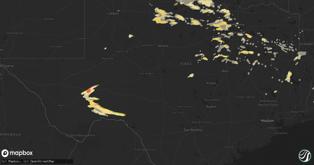
Hail Map in Texas on June 2, 2024
Get this storm
June 2 map
$229
one time, instant access
Download today. No call, no setup
Keep the $229
Bought the map and want the full workflow? Apply the entire $229 to a subscription within 7 days. None of it is wasted.
Every map, not just this one
This buys you this map. Subscription and you get every map we run, in the markets you choose from a few cities to whole states to nationwide. Plus real-time alerts the moment a storm fires.
Contact data
Name, contact info, occupancy, even credit band for addresses in the footprint. You go from where it hit to who to call.
Become the source they trust
Unlimited branding weather history reports on demand. You already have the documented answer ready for the property owner, and you are the one who showed up with it.
Property data and RoofTrace estimates
Pull up any address you have got, its value and the exact code rules for that jurisdiction, straight from One Click Code. Then RoofTrace estimates the squares, pitch, and roof value, priced the way you price.
Storm reports in Texas
Texas
| Date | Description |
|---|---|
| 06/02/20246:57 PM CDT | Several trees down. |
| 06/02/20246:49 PM CDT | This report was here at the nws amarillo office. |
| 06/02/20246:40 PM CDT | Power lines were downed across west jackson street in clarksville. |
| 06/02/20246:38 PM CDT | Three trees were downed across highway 37 between fm 2118 and fm 195. |
| 06/02/20246:37 PM CDT | A local report indicates 61 MPH wind near 6 ENE Amarillo |
| 06/02/20246:30 PM CDT | A local report indicates 1.25 inch wind near 6 SSW Amarillo |
| 06/02/20246:30 PM CDT | A local report indicates 1.25 inch wind near 4 NW Timbercreek Canyon |
| 06/02/20246:25 PM CDT | Roof blown off from commercial building. Time estimated from radar. |
| 06/02/20246:20 PM CDT | Report from mping: quarter |
| 06/02/20246:20 PM CDT | A local report indicates 1.75 inch wind near 14 N Amarillo |
| 06/02/20246:10 PM CDT | A local report indicates 1.00 inch wind near 16 SSE Canyon |
| 06/02/20246:05 PM CDT | A local report indicates 1.00 inch wind near 7 NW Canyon |
| 06/02/20246:00 PM CDT | Report from mping: quarter |
| 06/02/20245:57 PM CDT | Report from mping: half dollar |
| 06/02/20245:52 PM CDT | Report from mping: quarter |
| 06/02/20245:38 PM CDT | Report from mping: quarter |
| 06/02/20245:28 PM CDT | Hail ranged in size from half dollar to golf ball. |
| 06/02/20245:25 PM CDT | Hail ranged in size from golf ball to softball. |
| 06/02/20245:25 PM CDT | Golf ball sized hail on the south side of fort stockton. |
| 06/02/20245:24 PM CDT | Report from mping: golf ball |
| 06/02/20245:14 PM CDT | Ham report of a measured 59 mph wind gust in little elm near the 423 and el dorado intersection. |
| 06/02/20245:13 PM CDT | Report from mping: quarter |
| 06/02/20245:09 PM CDT | Report from mping: quarter |
| 06/02/20244:58 PM CDT | Report from mping: quarter |
| 06/02/20244:55 PM CDT | Report from mping: quarter |
| 06/02/20244:53 PM CDT | Ham report of ping-pong ball sized hail near loop 288 and hwy 77 in denton. |
| 06/02/20244:04 PM CDT | Cooke county em reported golf-ball sized hail on the east side of gainesville on hwy 82 east of radio hill rd. |
| 06/02/20243:55 PM CDT | Report from mping: quarter |
| 06/02/20243:35 PM CDT | Gle awos at the gainesville municipal airport reported a 61 mph wind gust. |
| 06/02/20241:56 PM CDT | Trained spotters report large tree limbs blown down by thunderstorm winds. |
| 06/01/20249:30 PM CDT | Picture sent via chat of a 6 inch hailstone measured with a tape measurer. |
| 06/01/20249:15 PM CDT | Corrects previous hail report from 2 ne caprock canyons state park visitors center to change the time. Picture sent via chat of a 6 inch hailstone measured with a tape |
| 06/01/20249:14 PM CDT | Golf ball size hail reported by tpwd law enforcement in caprock canyons state park. |
| 06/01/20249:09 PM CDT | Trees and power lines down. |
| 06/01/20249:07 PM CDT | Photos via social media. |
| 06/01/20249:05 PM CDT | At least 4.5 inch hail found on highway 256 after the storm passed with likely some melting. |
| 06/01/20249:03 PM CDT | Time and location estimated. Report from storm chaser via social media. |
| 06/01/20248:54 PM CDT | Trees and poer lines down. |
| 06/01/20248:46 PM CDT | Several trees down. |
| 06/01/20248:20 PM CDT | Tornado observed live on storm chaser video feed. |
| 06/01/20248:18 PM CDT | Multiple trees and power lines down. |
| 06/01/20248:10 PM CDT | A local report indicates 1.00 inch wind near 13 NW Codman |
| 06/01/20248:04 PM CDT | A local report indicates 2.00 inch wind near Hico |
| 06/01/20248:02 PM CDT | This is another observation of the initial tornado with this storm. |
| 06/01/20248:00 PM CDT | A picture was posted to social media of a tree that was snapped next to a home on fm 3098 northwest of redwater. |
| 06/01/20248:00 PM CDT | Trees down in tyler. |
| 06/01/20247:56 PM CDT | Location estimated by chaser. |
| 06/01/20247:55 PM CDT | Trees and power lines down. |
| 06/01/20247:50 PM CDT | Baseball size hail observed by storm chaser on live video feed. Spotter was about 1 mile east of vigo park. |
| 06/01/20247:49 PM CDT | Report from mping. |
| 06/01/20247:47 PM CDT | Trees and power lines down. |
| 06/01/20247:45 PM CDT | Several trees and power lines down. |
| 06/01/20247:37 PM CDT | Giant hail observed by broadcast media chaser 3 miles west-northwest of vigo park. The hail was 5+ inches in diameter. The hail appeared to be as long as a 16 oz monste |
| 06/01/20247:37 PM CDT | Corrects previous hail report from 10 nw mackenzie reservoir. Giant hail observed by broadcast media chaser 3 miles west-northwest of vigo park. The hail was 5+ inches |
| 06/01/20247:31 PM CDT | A local report indicates 1.75 inch wind near 4 WNW Sanford |
| 06/01/20247:30 PM CDT | Quarter size hail fell in mineola. |
| 06/01/20247:22 PM CDT | Several trees and power lines down. |
| 06/01/20247:20 PM CDT | The same supercell thunderstorm that caused the first tornado would quickly prouce another smaller tornado near the center of sanderson a short time later. This tornado |
| 06/01/20247:16 PM CDT | A second ef0 tornado formed and moved northeast between lake meredith and the bugbee community. Was on the ground for about 2 minutes with a path width of 75 yards and |
| 06/01/20247:15 PM CDT | Trees and power lines down in quitman. |
| 06/01/20247:15 PM CDT | Tornado with damage to buildings and power lines reported in sanderson. |
| 06/01/20247:14 PM CDT | Photos showed a tornado formed very near sanderson along a ridge northwest of town. This tornado immediately entered a neighborhood west of us highway 285 in sanderson. |
| 06/01/20247:12 PM CDT | Nws employee reported tornado on the ground. |
| 06/01/20247:11 PM CDT | Corrects previous tornado report from 4 wnw sanford. Nws employee reported tornado on the ground. This tornado formed over lake meredith. The track of the tornado was p |
| 06/01/20247:05 PM CDT | Trees and power lines down in the alba community. |
| 06/01/20247:02 PM CDT | Partner at pantex. |
All States Impacted by Hail Map on June 2, 2024
Cities Impacted by Hail Map on June 2, 2024
- Moorefield, NE
- Shamrock, TX
- Pampa, TX
- Mclean, TX
- Eustis, NE
- Papillion, NE
- Farnam, NE
- Pingree, ND
- Norton, KS
- Elwood, NE
- Offutt Afb, NE
- Bellevue, NE
- Wellington, TX
- Wilsonville, NE
- Hendley, NE
- Council Bluffs, IA
- Cambridge, NE
- Chillicothe, TX
- Eldorado, OK
- Beaver City, NE
- Holbrook, NE
- Arapahoe, NE
- Vernon, TX
- Dodson, TX
- Hollis, OK
- Edison, NE
- Hartland, MN
- Albert Lea, MN
- Long Island, KS
- Oxford, NE
- Gould, OK
- Duke, OK
- Mangum, OK
- Orleans, NE
- Cimarron, KS
- Odell, TX
- Phillipsburg, KS
- Prairie View, KS
- Stamford, NE
- Olustee, OK
- Holdrege, NE
- Atlanta, NE
- Dodge City, KS
- Altus, OK
- Elmer, OK
- Electra, TX
- Blair, OK
- Cleveland, ND
- Harrold, TX
- Medina, ND
- Frederick, OK
- Pierre Part, LA
- Morgan City, LA
- Napoleonville, LA
- Altus Afb, OK
- Iowa Park, TX
- Burkburnett, TX
- Davidson, OK
- Oklaunion, TX
- Spearville, KS
- Loveland, OK
- Arnaudville, LA
- Wichita Falls, TX
- Thibodaux, LA
- Gibson, LA
- Grandfield, OK
- Hollister, OK
- Walters, OK
- Devol, OK
- Schriever, LA
- Donner, LA
- Saint Martinville, LA
- Chattanooga, OK
- Breaux Bridge, LA
- Lawton, OK
- Faxon, OK
- Theriot, LA
- Indiahoma, OK
- Snyder, OK
- Cache, OK
- Medicine Park, OK
- Elba, NE
- Chickasha, OK
- Loreauville, LA
- Jeanerette, LA
- New Iberia, LA
- Cement, OK
- Anadarko, OK
- Fletcher, OK
- Paducah, TX
- Wing, ND
- Temple, OK
- Tuttle, ND
- Petrolia, TX
- Ninnekah, OK
- Verden, OK
- Geronimo, OK
- Waurika, OK
- Sheppard Afb, TX
- Comanche, OK
- Duncan, OK
- Chaseley, ND
- Seymour, TX
- Oklahoma City, OK
- Yukon, OK
- Robinson, ND
- Hurdsfield, ND
- Bowdon, ND
- Edmond, OK
- Walden, CO
- Bethany, OK
- Hastings, OK
- Randlett, OK
- Benjamin, TX
- Dunseith, ND
- Byers, TX
- Knox City, TX
- Munday, TX
- Ryan, OK
- Ringling, OK
- Loco, OK
- New Rockford, ND
- Old Glory, TX
- Mylo, ND
- Henrietta, TX
- Holliday, TX
- Saint John, ND
- Goree, TX
- O'Brien, TX
- Elmore City, OK
- Sheyenne, ND
- Kaplan, LA
- Hennepin, OK
- Ratliff City, OK
- Rocklake, ND
- Graham, OK
- Healdton, OK
- Harrisburg, NE
- Leeds, ND
- Rochester, TX
- Cando, ND
- Springer, OK
- Wilson, OK
- Ardmore, OK
- Davis, OK
- Woodworth, ND
- Weinert, TX
- Terral, OK
- Ringgold, TX
- Throckmorton, TX
- Rule, TX
- Nocona, TX
- Lone Grove, OK
- Mcclusky, ND
- Crawford, NE
- Wishek, ND
- Zeeland, ND
- Hague, ND
- Bellevue, TX
- New England, ND
- Egeland, ND
- Haskell, TX
- Abbeville, LA
- Newcastle, TX
- Bayard, NE
- Langdon, ND
- Munich, ND
- Denhoff, ND
- Olney, TX
- Bowie, TX
- Lindsay, TX
- Saint Jo, TX
- Muenster, TX
- Gainesville, TX
- Goodrich, ND
- Manville, WY
- Dalton, NE
- Bridgeport, NE
- Potter, NE
- Wales, ND
- Prairie City, SD
- Martin, ND
- Montague, TX
- Burneyville, OK
- Leon, OK
- Bushnell, NE
- Las Animas, CO
- Pine Bluffs, WY
- Lusk, WY
- Lehr, ND
- Mud Butte, SD
- Meadow, SD
- Harvey, ND
- Loving, TX
- McLaughlin, SD
- Gering, NE
- Fort Stockton, TX
- Napoleon, ND
- Hay Springs, NE
- Fessenden, ND
- Gurley, NE
- Graham, TX
- Mill Creek, OK
- Tishomingo, OK
- Mott, ND
- New Raymer, CO
- Dickinson, ND
- Jacksboro, TX
- Windthorst, TX
- Forestburg, TX
- Madill, OK
- Gackle, ND
- Sidney, NE
- Whitesboro, TX
- Faith, SD
- Buchanan, ND
- Kenefic, OK
- Ellsworth, NE
- Jermyn, TX
- Bryson, TX
- Padroni, CO
- Krum, TX
- Valley View, TX
- Collinsville, TX
- Gladstone, ND
- Fredonia, ND
- Minnewaukan, ND
- Milburn, OK
- Bingham, NE
- Merriman, NE
- Decatur, TX
- Sanger, TX
- Lemmon, SD
- Tappen, ND
- Saint Peter, MN
- Maddock, ND
- Rushville, NE
- Tioga, TX
- Lodgepole, NE
- Dawson, ND
- Pilot Point, TX
- Le Sueur, MN
- Denton, TX
- Ponder, TX
- Bridgeport, TX
- Devils Lake, ND
- Perrin, TX
- Chico, TX
- Le Center, MN
- Hettinger, ND
- Penn, ND
- Dupree, SD
- Lake Dallas, TX
- Chappell, NE
- Walsh, CO
- Deridder, LA
- Alliance, NE
- Poolville, TX
- Dequincy, LA
- Paradise, TX
- Lewisville, TX
- Argyle, TX
- San Saba, TX
- Sedgwick, CO
- Ovid, CO
- Julesburg, CO
- Pettibone, ND
- Ashby, NE
- Evans, LA
- Goldthwaite, TX
- Rhome, TX
- Little Elm, TX
- Aubrey, TX
- Flower Mound, TX
- Justin, TX
- Frisco, TX
- Keldron, SD
- Montgomery, MN
- Celina, TX
- Holly, CO
- Leesville, LA
- Haslet, TX
- Sterling, CO
- Roanoke, TX
- Iroquois, SD
- Springtown, TX
- Boyd, TX
- Azle, TX
- Longville, LA
- Flagler, CO
- Newark, TX
- The Colony, TX
- Southlake, TX
- Aledo, TX
- Weatherford, TX
- New Prague, MN
- Clear Lake, SD
- Cottonwood, MN
- Fort Worth, TX
- Streeter, ND
- Brinson, GA
- Little Eagle, SD
- Whitman, NE
- Rapid City, SD
- Yale, SD
- Boswell, OK
- Manter, KS
- Syracuse, KS
- Livingston, TX
- Colleyville, TX
- Ragley, LA
- Irving, TX
- Carpenter, SD
- Willow Lake, SD
- Dallas, TX
- Sunray, TX
- Kilkenny, MN
- Waterville, MN
- Jamestown, ND
- Highmore, SD
- Ree Heights, SD
- Happy, TX
- Dublin, TX
- New Leipzig, ND
- Cherry Creek, SD
- Frederick, SD
- Westport, SD
- Faribault, MN
- Dumas, TX
- Haltom City, TX
- North Richland Hills, TX
- Venango, NE
- Cleveland, MN
- Elysian, MN
- Amarillo, TX
- Rice, TX
- Elgin, ND
- Bainbridge, GA
- Canyon, TX
- Midland, SD
- Barnard, SD
- Chatfield, TX
- Miller, SD
- Corsicana, TX
- Kerens, TX
- Saint Lawrence, SD
- Redfield, SD
- Tulare, SD
- Ashton, SD
- Mansfield, SD
- Rockham, SD
- Aberdeen, SD
- Northville, SD
- Huntsville, TX
- Gary, SD
- Marietta, MN
- Holyoke, CO
- Wray, CO
- Ypsilanti, ND
- Canby, MN
- Selfridge, ND
- Imperial, NE
- Linton, ND
- Lower Brule, SD
- Royse City, TX
- Terrell, TX
- Grant, NE
- Quinlan, TX
- Mckinney, TX
- Clark, SD
- Elkhart, KS
- Wessington, SD
- Morgan, TX
- Kopperl, TX
- Nerstrand, MN
- Northfield, MN
- Blum, TX
- Dennison, MN
- Kenyon, MN
- Burleson, TX
- Columbia, SD
- Mansfield, TX
- Corrigan, TX
- Diboll, TX
- Madrid, NE
- Vona, CO
- Kintyre, ND
- Vienna, SD
- Fort Yates, ND
- Wills Point, TX
- Erwin, SD
- Bryant, SD
- Groveton, TX
- Kennard, TX
- Joshua, TX
- Godley, TX
- Crowley, TX
- Powell, TX
- Madison, MN
- Idalia, CO
- Zavalla, TX
- Watertown, SD
- Buffalo, TX
- Allen, TX
- Kaufman, TX
- Oakwood, TX
- Hecla, SD
- Hayes, SD
- Houghton, SD
- Panhandle, TX
- Montpelier, ND
- Bird City, KS
- Stratton, CO
- Stinnett, TX
- Henry, SD
- Fairfield, TX
- Lufkin, TX
- Champion, NE
- Marion, ND
- Elsie, NE
- Hayes Center, NE
- Wauneta, NE
- Burlington, CO
- Apple Springs, TX
- Saint Francis, KS
- Florence, SD
- Stratton, NE
- Mabank, TX
- Kemp, TX
- Emory, TX
- Madison Lake, MN
- Trinidad, TX
- Dryden, TX
- Litchville, ND
- Dickey, ND
- Claremont, SD
- Tennessee Colony, TX
- Palestine, TX
- Trenton, NE
- Webster, SD
- Huntington, TX
- Wayside, TX
- Tulia, TX
- Maywood, NE
- McCook, NE
- Grand Saline, TX
- Alba, TX
- Palisade, NE
- Sutherland, NE
- Claude, TX
- Canton, TX
- Paxton, NE
- Malakoff, TX
- Wallace, SD
- McDonald, KS
- Valentine, NE
- Venus, TX
- Alvarado, TX
- Johnson, KS
- Fritch, TX
- Wellfleet, NE
- Curtis, NE
- Culbertson, NE
- Benkelman, NE
- Saint Francis, SD
- Parmelee, SD
- Mission, SD
- Max, NE
- Waubay, SD
- Montalba, TX
- Mineola, TX
- Miltona, MN
- Carlos, MN
- Parkers Prairie, MN
- Raymond, SD
- Enders, NE
- Stephenville, TX
- Hico, TX
- Cleburne, TX
- Lockney, TX
- Plainview, TX
- Alexandria, MN
- Athens, TX
- Eustace, TX
- Maxwell, NE
- Brady, NE
- Silverton, TX
- Kathryn, ND
- Midlothian, TX
- Sanderson, TX
- Melissa, TX
- Marvin, SD
- Borger, TX
- Lindale, TX
- Chireno, TX
- Etoile, TX
- Ben Wheeler, TX
- Hillsboro, TX
- Itasca, TX
- Lake Norden, SD
- Verona, ND
- Fort Ransom, ND
- Lisbon, ND
- Nome, ND
- Larue, TX
- Winner, SD
- Ortonville, MN
- Odessa, MN
- Goodland, KS
- Nacogdoches, TX
- Avon, MN
- Cold Spring, MN
- Richmond, MN
- Reliance, SD
- Big Sandy, TX
- Hawkins, TX
- Big Stone City, SD
- Rio Vista, TX
- Keene, TX
- Tryon, NE
- North Platte, NE
- Covington, TX
- Tyler, TX
- Chandler, TX
- Pine Island, MN
- New Boston, TX
- Langford, SD
- Enderlin, ND
- Iredell, TX
- Milford, TX
- Fleming, CO
- Haxtun, CO
- Big Springs, NE
- Brule, NE
- Amherst, CO
- Ogallala, NE
- Wallace, NE
- Dickens, NE
- Hershey, NE
- Parks, NE
- Lamoure, ND
- Wolsey, SD
- Garden City, SD
- Fullerton, ND
- Atwood, KS
- Correll, MN
- Chokio, MN
- Strasburg, ND
- Marathon, TX
- Gladewater, TX
- Winona, TX
- Carlton, TX
- Tarzan, TX
- Beardsley, MN
- Clinton, MN
- Wilmot, SD
- Flint, TX
- Fluvanna, TX
- Frankfort, SD
- Gilmer, TX
- Witten, SD
- Ideal, SD
- Breckenridge, TX
- Caddo, TX
- Mingus, TX
- Woodson, TX
- Ranger, TX
- Indianola, NE
- Keystone, NE
- Stapleton, NE
- Cozad, NE
- Callaway, NE
- Gothenburg, NE
- Stockville, NE
- Miami, TX
- Willow Island, NE
- Bartley, NE
- Eddyville, NE
- Mason City, NE
- Broken Bow, NE
- Ansley, NE
- Lexington, NE
- Sumner, NE
- Oconto, NE
- Smithfield, NE
- Overton, NE
- Ellendale, ND
- Anselmo, NE
- Turton, SD
- Doland, SD
- Longview, TX
- Bradley, SD
- Owatonna, MN
- Alberta, MN
- Morris, MN
- White Oak, TX
- Forbes, ND
- Elkhart, TX
- Kilgore, TX
- Whitehouse, TX
- Huron, SD
- Norcatur, KS
- Oberlin, KS
- Lebanon, NE
- Danbury, NE
- Clarendon, TX
- Comstock, TX
- Claremont, MN
- Troup, TX
- Henderson, TX
- Overton, TX
- Roslyn, SD
- Selman City, TX
- Sisseton, SD
- Britton, SD
- Oakes, ND
- Hallsville, TX
- Chamberlain, SD
- Snyder, TX
- Center, TX
- Eden, SD
- Grenville, SD
- Claire City, SD
- Milnor, ND
- Gwinner, ND
- Estelline, SD
- Arlington, SD
- Lidgerwood, ND
- Veblen, SD
- Marshall, TX
- Leola, SD
- Dodge Center, MN
- Wheaton, MN
- Beckville, TX
- Joaquin, TX
- Tenaha, TX
- Donnelly, MN
- Tatum, TX
- Jacksonville, TX
- Alpena, SD
- Zap, ND
- Beulah, ND
- Lenora, KS
- Herndon, KS
- Jennings, KS
- Bertrand, NE
- Miller, NE
- Clayton, KS
- Bruce, SD
- Quitaque, TX
- Jefferson, TX
- Barrett, MN
- Herman, MN
- Burwell, NE
- Comstock, NE
- Kasson, MN
- Long Prairie, MN
- Swanville, MN
- Browerville, MN
- Stirum, ND
- Appleton, MN
- Elm Creek, NE
- Logan, KS
- Hill City, KS
- Loomis, NE
- Almena, KS
- Bogue, KS
- Amherst, NE
- Pleasanton, NE
- Stockton, KS
- Alma, NE
- Grand Island, NE
- Kensington, KS
- Naponee, NE
- Heartwell, NE
- Franklin, NE
- Cairo, NE
- Republican City, NE
- Hazard, NE
- Ravenna, NE
- Litchfield, NE
- Bloomington, NE
- Glade, KS
- Agra, KS
- Boelus, NE
- Upland, NE
- Funk, NE
- Gibbon, NE
- Kenesaw, NE
- Riverdale, NE
- Axtell, NE
- Odessa, NE
- Wood River, NE
- Kearney, NE
- Wilcox, NE
- Hildreth, NE
- Shelton, NE
- Minden, NE
- Rockville, NE
- Arcadia, NE
- Dannebrog, NE
- Loup City, NE
- Ashton, NE
- Arnold, NE
- Westerville, NE
- Merna, NE
- Ord, NE
- North Loup, NE
- Greeley, NE
- Wolbach, NE
- Saint Paul, NE
- Farwell, NE
- Scotia, NE
- Turkey, TX
- Childress, TX
- Oil City, LA
- De Berry, TX
- Randall, MN
- Little Falls, MN
- Ida, LA
- Vivian, LA
- Mantorville, MN
- Holloway, MN
- Wyndmere, ND
- Ennis, TX
- Carthage, TX
- Keatchie, LA
- Logansport, LA
- Gary, TX
- Scurry, TX
- Abbott, TX
- Saint Libory, NE
- Alda, NE
- Halliday, ND
- Hazen, ND
- Byron, MN
- Stonewall, LA
- Grand Cane, LA
- Gloster, LA
- Keithville, LA
- Castlewood, SD
- Bristol, SD
- Mooringsport, LA
- Amherst, SD
- Aquilla, TX
- Whitney, TX
- Palmer, NE
- Chapman, NE
- Archer, NE
- Central City, NE
- Fullerton, NE
- Belgrade, NE
- Groton, SD
- New Salem, ND
- Frierson, LA
- Kimball, SD
- Danvers, MN
- Benson, MN
- Hubbard, TX
- Dawson, TX
- West, TX
- Golden Valley, ND
- Arlington, TX
- Grand Prairie, TX
- Euless, TX
- Hurst, TX
- Meridian, TX
- Barry, TX
- Bedford, TX
- Wylie, TX
- Ewing, NE
- Coolidge, TX
- Alto, TX
- Andover, SD
- Grapevine, TX
- Clearwater, NE
- Murdock, MN
- Rockwall, TX
- Forney, TX
- Sunnyvale, TX
- Garland, TX
- Lavon, TX
- Rowlett, TX
- Mesquite, TX
- Lebanon, KS
- Princeton, TX
- Crandall, TX
- Kerkhoven, MN
- Sunburg, MN
- Ortley, SD
- Conde, SD
- Pennock, MN
- Tintah, MN
- Eads, CO
- Mitchell, SD
- Dundas, MN
- Hendricks, MN
- Willmar, MN
- Elyria, NE
- Burr Oak, KS
- Waco, NE
- Idalou, TX
- Strandburg, SD
- Goodwin, SD
- Ivanhoe, MN
- Arapahoe, CO
- Spicer, MN
- Friend, NE
- Milford, NE
- New London, MN
- Gresham, NE
- Milligan, NE
- Tobias, NE
- Superior, NE
- Mankato, KS
- Beaver Crossing, NE
- Ohiowa, NE
- York, NE
- Van, TX
- Grandview, TX
- Maypearl, TX
- Waxahachie, TX
- Tribune, KS
- Utica, NE
- Labolt, SD
- Revillo, SD
- Hardy, NE
- Dorchester, NE
- Bruning, NE
- Kandiyohi, MN
- Alexandria, SD
- Fulton, SD
- Kingman, KS
- Streetman, TX
- Bynum, TX
- Penelope, TX
- Malone, TX
- Goehner, NE
- Seward, NE
- Spivey, KS
- Sheridan Lake, CO
- Alexandria, NE
- Emery, SD
- Italy, TX
- Pineland, TX
- Salem, SD
- Montrose, SD
- Arp, TX
- Purdon, TX
- Akron, IA
- Canistota, SD
- Bridgewater, SD
- Elk Point, SD
- Norwich, KS
- Richland, TX
- Alcester, SD
- Hawarden, IA
- Leoti, KS
- Rusk, TX
- Cheney, KS
- Wheeler, TX
- Saint Joseph, MN
- Viola, KS
- Milton, KS
- Goddard, KS
- Garden Plain, KS
- Lakin, KS
- Renville, MN
- Galva, KS
- Hitchcock, SD
- Canton, KS
- Olivia, MN
- Redwood Falls, MN
- Danube, MN
- Kendall, KS
- Moundridge, KS
- Newton, KS
- Hillsboro, KS
- Goessel, KS
- Bird Island, MN
- Holcomb, KS
- Wright, KS
- Lehigh, KS
- Marion, KS
- Peabody, KS
- Ulysses, KS
- Edson, KS
- Garden City, KS
- Soper, OK
- Gibbon, MN
- Winthrop, MN
- Hydro, OK
- Binger, OK
- Hugo, OK
- Cassoday, KS
- Durham, KS
- Englewood, KS
- Lookeba, OK
- Montezuma, KS
- Ashland, KS
- Pocasset, OK
- Matfield Green, KS
- Ensign, KS
- Sublette, KS
- Gracemont, OK
- Minco, OK
- Minneola, KS
- Protection, KS
- Copeland, KS
- Fowler, KS
- Amber, OK
- Blanchard, OK
- Ireton, IA
- Choctaw, OK
- Newalla, OK
- Bucklin, KS
- Ford, KS
- Coldwater, KS
- Burns, KS
- Cedar Point, KS
- Hamilton, KS
- Eureka, KS
- Harrah, OK
- Norman, OK
- Wellston, OK
- Luther, OK
- Madison, KS
- Meade, KS
- Mcloud, OK
- Noble, OK
- Mullinville, KS
- Tecumseh, OK
- Virgil, KS
- Spencer, OK
- Pierceville, KS
- Ingalls, KS
- Satanta, KS
- Plains, KS
- Jetmore, KS
- Wilmore, KS
- Haviland, KS
- Greensburg, KS
- Severy, KS
- Shawnee, OK
- Gridley, KS
- Wanette, OK
- Beaver, OK
- Balko, OK
- Coats, KS
- Sun City, KS
- Pratt, KS
- Sawyer, KS
- Asher, OK
- Lake City, KS
- Konawa, OK
- Maud, OK
- Ada, OK
- Toronto, KS
- Macomb, OK
- Yates Center, KS
- Byars, OK
- Arkansas City, KS
- Geuda Springs, KS
- Medicine Lodge, KS
- Hardtner, KS
- Iuka, KS
- Offerle, KS
- Laverne, OK
- Rosston, OK
- Okmulgee, OK
- Independence, KS
- Havana, KS
- Fall River, KS
- Mayfield, KS
- Allen, OK
- Sasakwa, OK
- Shattuck, OK
- Wellington, KS
- Seminole, OK
- Wichita, KS
- Atwood, OK
- Holdenville, OK
- Wewoka, OK
- Cedar Vale, KS
- Moline, KS
- Fargo, OK
- Sedan, KS
- Peck, KS
- Belle Plaine, KS
- Stonewall, OK
- Peru, KS
- Calvin, OK
- Kiowa, KS
- Hazelton, KS
- Sharon, KS
- Isabel, KS
- Rose Hill, KS
- Derby, KS
- Andover, KS
- Howard, KS
- Coffeyville, KS
- Elk Falls, KS
- Valley Center, KS
- Kechi, KS
- Niotaze, KS
- Mulvane, KS
- Gage, OK
- Stockholm, SD
- Kranzburg, SD


