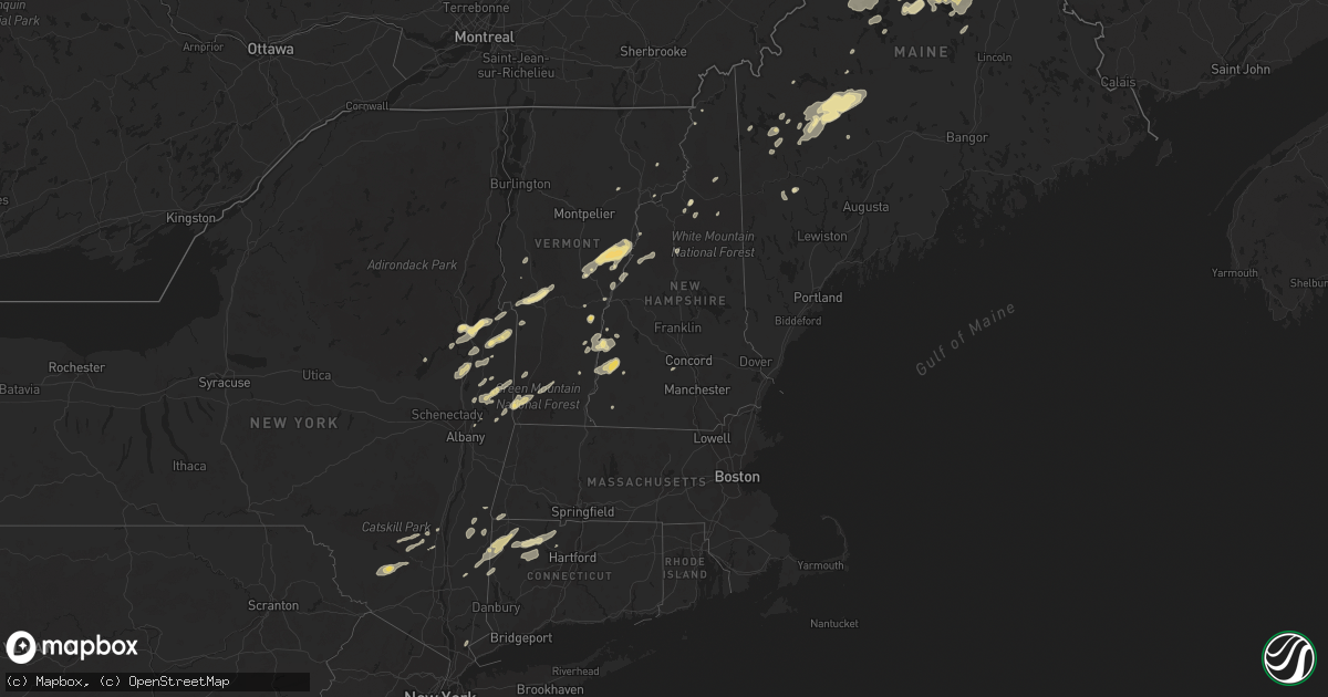
Hail Map in Vermont on June 2, 2013
Get this storm
June 2 map
$229
one time, instant access
Download today. No call, no setup
Keep the $229
Bought the map and want the full workflow? Apply the entire $229 to a subscription within 7 days. None of it is wasted.
Every map, not just this one
This buys you this map. Subscription and you get every map we run, in the markets you choose from a few cities to whole states to nationwide. Plus real-time alerts the moment a storm fires.
Contact data
Name, contact info, occupancy, even credit band for addresses in the footprint. You go from where it hit to who to call.
Become the source they trust
Unlimited branding weather history reports on demand. You already have the documented answer ready for the property owner, and you are the one who showed up with it.
Property data and RoofTrace estimates
Pull up any address you have got, its value and the exact code rules for that jurisdiction, straight from One Click Code. Then RoofTrace estimates the squares, pitch, and roof value, priced the way you price.
Storm reports in Vermont
Vermont
| Date | Description |
|---|---|
| 06/02/20132:33 PM CDT | Several tree limbs down |
| 06/02/20132:15 PM CDT | Multiple trees down |
| 06/02/20132:12 PM CDT | Numerous trees and power lines down |
| 06/02/20132:12 PM CDT | Tree down |
| 06/02/20132:12 PM CDT | Several trees down |
| 06/02/20132:11 PM CDT | Numerous trees and wires down plainfield and marshfield area |
| 06/02/20132:11 PM CDT | Trees and power lines down |
| 06/02/20132:10 PM CDT | Numerous trees down |
| 06/02/20132:09 PM CDT | 1 tree down |
| 06/02/20132:06 PM CDT | Numerous trees down from saint johnsbury center to saint johnsbury along route 5 |
| 06/02/20132:05 PM CDT | Six trees down |
| 06/02/20132:00 PM CDT | Few trees down |
| 06/02/20131:54 PM CDT | A local report indicates 1.50 inch wind near WEST FAIRLEE CENTER |
| 06/02/20131:48 PM CDT | Several trees down |
| 06/02/20131:45 PM CDT | Large tree falling on two parked trucks. |
| 06/02/20131:45 PM CDT | Dime to quarter size hail |
| 06/02/20131:42 PM CDT | Numerous trees and wires down |
| 06/02/20131:41 PM CDT | Trees down |
| 06/02/20131:32 PM CDT | Numerous trees and wires down on happy hollow road |
| 06/02/20131:30 PM CDT | Tree down on country club road |
| 06/02/20131:24 PM CDT | Numerous trees down in barre |
| 06/02/20131:24 PM CDT | Numerous trees down in east montpelier |
| 06/02/20131:18 PM CDT | Tree down on towne hill road |
| 06/02/20131:05 PM CDT | A local report indicates 1.00 inch wind near CHITTENDEN |
| 06/02/201312:59 PM CDT | Several trees down on york hill road |
| 06/02/201312:59 PM CDT | Trees down |
| 06/02/201312:55 PM CDT | Trees wires down grove street |
| 06/02/201312:50 PM CDT | Numerous trees and wires down |
| 06/02/201312:39 PM CDT | Trees and wires down |
All States Impacted by Hail Map on June 2, 2013
Cities Impacted by Hail Map on June 2, 2013
- Sumner, ME
- Berlin, NH
- Covington, GA
- Thornton, NH
- South Acworth, NH
- Alstead, NH
- Marlow, NH
- Lizella, GA
- Cloudcroft, NM
- Dell City, TX
- Fort Hancock, TX
- Tinnie, NM
- Capitan, NM
- Fairlee, VT
- Strafford, VT
- West Fairlee, VT
- Bradford, VT
- Vershire, VT
- Chelsea, VT
- Corinth, VT
- Tunbridge, VT
- Sierra Blanca, TX
- Roundup, MT
- Bethlehem, NH
- Bretton Woods, NH
- Twin Mountain, NH
- Mountainair, NM
- Belen, NM
- Jarales, NM
- Sinclair, ME
- Stockholm, ME
- Sabinal, TX
- Goshen, CT
- Lovington, NM
- Plains, TX
- Denver City, TX
- Rangeley, ME
- Brewton, AL
- Macon, GA
- Forsyth, MT
- Santa Rosa, TX
- Doerun, GA
- Socorro, NM
- Houlton, ME
- Smyrna Mills, ME
- Patten, ME
- Rocky Mount, VA
- Kattskill Bay, NY
- Fort Ann, NY
- Lake George, NY
- Warrensburg, NY
- Queensbury, NY
- Lyford, TX
- Loganville, GA
- La Mesa, NM
- McRae Helena, GA
- Kent, CT
- West Cornwall, CT
- Cornwall Bridge, CT
- Sharon, CT
- Thomaston, GA
- Fort Valley, GA
- Hanover, NH
- Lyme, NH
- East Thetford, VT
- Andover, ME
- Charlestown, NH
- Springfield, VT
- Claremont, NH
- Dahlonega, GA
- Buskirk, NY
- Rebecca, GA
- Hackberry, LA
- Zebulon, GA
- Barnesville, GA
- Milner, GA
- Meansville, GA
- Veguita, NM
- Dawsonville, GA
- Byron, GA
- Van Buren, ME
- Greenville, ME
- Kingfield, ME
- Strong, ME
- New Portland, ME
- Bingham, ME
- Middlebury, VT
- Salisbury, VT
- Fayetteville, GA
- Riverdale, GA
- Jonesboro, GA
- Wassaic, NY
- Lagrangeville, NY
- Amenia, NY
- Dover Plains, NY
- Wingdale, NY
- Millbrook, NY
- Falls Village, CT
- South Glens Falls, NY
- Winsted, CT
- Torrington, CT
- New Hartford, CT
- Barkhamsted, CT
- Johnsonville, NY
- Musselshell, MT
- Bighorn, MT
- Custer, MT
- Worden, MT
- Shepherd, MT
- Hysham, MT
- Roanoke, VA
- Bent Mountain, VA
- Clermont, FL
- Montverde, FL
- Bellows Falls, VT
- Acworth, NH
- Walpole, NH
- Westminster, VT
- North Walpole, NH
- Lake City, FL
- Stillwater, NY
- Greenwich, NY
- Schuylerville, NY
- Lavina, MT
- Nashville, GA
- Windsor, VT
- Brownsville, VT
- Reading, VT
- Mcdonough, GA
- Locust Grove, GA
- Troy, NY
- Honea Path, SC
- Belton, SC
- El Paso, TX
- Carrizozo, NM
- Hartford, NY
- Granville, NY
- Fort Edward, NY
- Hudson Falls, NY
- Argyle, NY
- Griffin, GA
- Weatogue, CT
- Simsbury, CT
- West Simsbury, CT
- Rosebud, MT
- Mercedes, TX
- La Feria, TX
- Mountain Dale, NY
- Wurtsboro, NY
- Rock Hill, NY
- Alamogordo, NM
- Phillips, ME
- Ashburn, GA
- Milan, GA
- Hoosick Falls, NY
- Bennington, VT
- North Bennington, VT
- Roberta, GA
- Schaghticoke, NY
- Mechanicville, NY
- Valley Falls, NY
- Cambridge, NY
- Saint Francis, ME
- Orlando, FL
- Anson, ME
- Eagle Lake, ME
- Wallagrass, ME
- Accord, NY
- Stone Ridge, NY
- Kerhonkson, NY
- Smyrna, GA
- Mableton, GA
- Rockwood, ME
- Greenville Junction, ME
- Pine Bush, NY
- Glen Wild, NY
- Greenfield Park, NY
- Ellenville, NY
- Monticello, NY
- Woodridge, NY
- Boones Mill, VA
- Warren, NH
- Reynolds, GA
- Weld, ME
- Pittsford, VT
- Florence, VT
- Chittenden, VT
- Rutland, VT
- Proctor, VT
- West Rutland, VT
- Perry, GA
- Fort Kent, ME
- Eustis, ME
- Concord, GA
- Williamson, GA
- Hopewell Junction, NY
- Northfield, CT
- Litchfield, CT
- Harwinton, CT
- Jenkinsburg, GA
- Jackson, GA
- Milledgeville, GA
- Chula, GA
- Tifton, GA
- Whitehall, NY
- Clint, TX
- Tornillo, TX
- Wirtz, VA
- Callaway, VA
- Whitefield, NH
- Townshend, VT
- Jefferson, NH
- Weirsdale, FL
- Lady Lake, FL
- South Woodstock, VT
- Woodstock, VT
- Northville, NY
- Valhalla, NY
- Thornwood, NY
- Pleasantville, NY
- Armonk, NY
- South Royalton, VT
- North Haverhill, NH
- Woodsville, NH
- Cropseyville, NY
- Petersburg, NY
- Van Horn, TX
- Cornish, NH
- Saratoga Springs, NY
- Gansevoort, NY
- Greenfield Center, NY
- Ocilla, GA
- Sale City, GA
- Caratunk, ME
- Shaftsbury, VT
- Howey In The Hills, FL
- Yatesville, GA
- The Rock, GA
- Andalusia, AL
- Sumner, GA
- Stoddard, NH
- Weimar, TX
- Schulenburg, TX
- Hallettsville, TX
- Arlington, VT
- Ocklawaha, FL
- Melrose, NY
- Altamonte Springs, FL
- Gordon, GA
- Bell City, LA
- Limestone, ME
- Caribou, ME
- Corona, NM
- Island Falls, ME
- Chester, VT
- Perkinsville, VT
- High Falls, NY
- San Acacia, NM
- Magdalena, NM
- Post Mills, VT
- Thetford Center, VT
- Glens Falls, NY
- Swanzey, NH
- Pelzer, SC
- Bosque, NM
- Millerton, NY
- Pine Plains, NY
- Jeffersonville, GA
- Dry Branch, GA
- Lake Butler, FL
- West Dover, VT
- West Wardsboro, VT
- Chicopee, MA
- West Springfield, MA
- Piermont, NH
- Orford, NH
- Chauncey, GA
- Newbury, VT
- Bethel, VT
- East Corinth, VT
- Randolph Center, VT
- Leesburg, FL
- Okahumpka, FL
- Rhine, GA
- East Burke, VT
- North Concord, VT
- Casselberry, FL
- Longwood, FL
- Castleton, VT
- Rosendale, NY
- New Paltz, NY
- Tillson, NY
- Hampton, GA
- Eagle Bridge, NY
- Cuero, TX
- Winter Park, FL
- Colebrook, NH
- Bryant Pond, ME
- West Paris, ME
- Ancram, NY
- Marble Hill, GA
- Ellijay, GA
- Salisbury, CT
- Sheffield, MA
- Butler, GA
- Conyers, GA
- Stockbridge, GA
- Weslaco, TX
- Progreso, TX
- Saint Johnsbury, VT
- Concord, VT
- Newport, NH
- Hampton, FL
- Hartwell, GA
- Anderson, SC
- Brandon, VT
- Kingston, NY
- West Hurley, NY
- Hurley, NY
- Copake, NY
- Copake Falls, NY
- Stanfordville, NY
- Glen Gardner, NJ
- Hampton, NJ
- Lake Luzerne, NY
- Tatum, NM
- Shorter, AL
- Hadley, NY
- Corinth, NY
- Utopia, TX
- Westfield, MA
- Southwick, MA
- Lawrenceville, GA
- Norwich, VT
- Cadwell, GA
- Fitzgerald, GA
- Townville, SC
- Starke, FL
- Atlanta, GA
- West Forks, ME
- White River Junction, VT
- Roxbury, ME
- Weare, NH
- Groveland, FL
- Marshallville, GA
- Riverton, CT
- Canton, CT
- West Granby, CT
- Bomoseen, VT
- Center Rutland, VT
- Fair Haven, VT
- Hardy, VA
- Poultney, VT
- Middletown Springs, VT
- Wells, VT
- Cabot, VT
- West Danville, VT
- Cleveland, GA
- Clinton Corners, NY
- Olivebridge, NY
- West Shokan, NY
- Grahamsville, NY
- Napanoch, NY
- South Kent, CT
- Sherman, CT
- Gaylordsville, CT
- New Milford, CT


