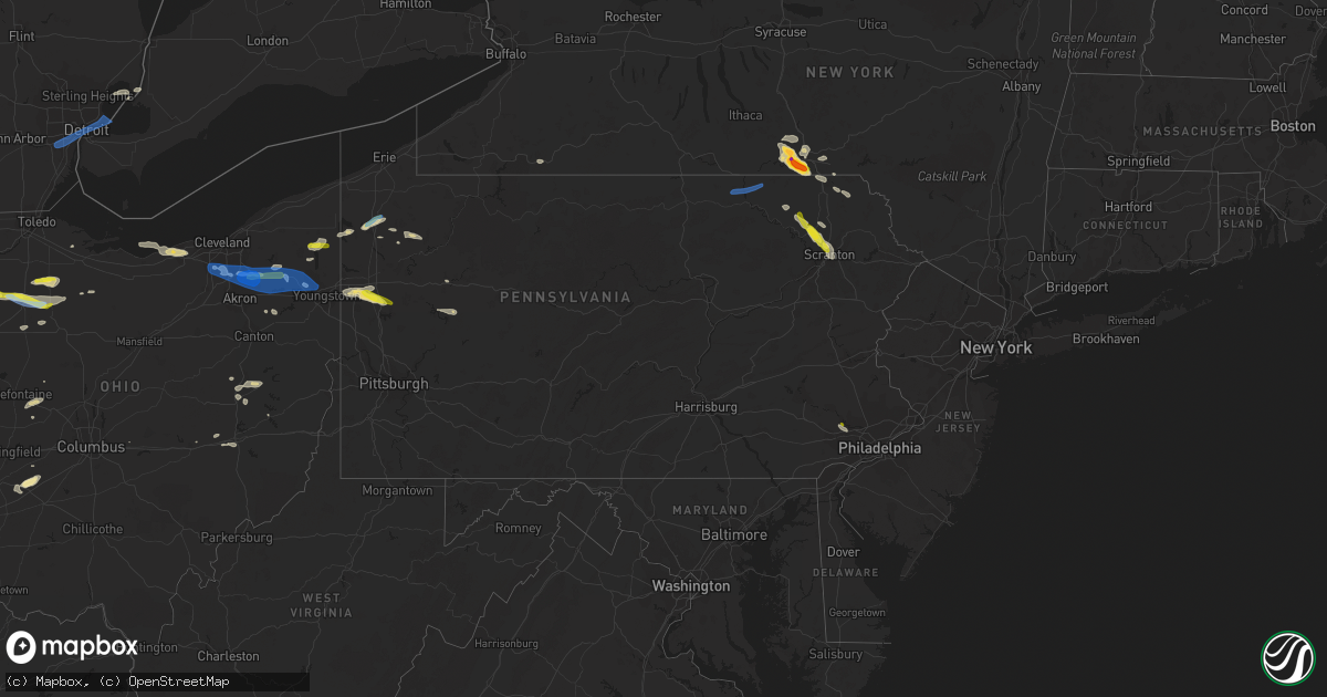
Hail Map in Pennsylvania on June 1, 2022
Get this storm
June 1 map
$229
one time, instant access
Download today. No call, no setup
Keep the $229
Bought the map and want the full workflow? Apply the entire $229 to a subscription within 7 days. None of it is wasted.
Every map, not just this one
This buys you this map. Subscription and you get every map we run, in the markets you choose from a few cities to whole states to nationwide. Plus real-time alerts the moment a storm fires.
Contact data
Name, contact info, occupancy, even credit band for addresses in the footprint. You go from where it hit to who to call.
Become the source they trust
Unlimited branding weather history reports on demand. You already have the documented answer ready for the property owner, and you are the one who showed up with it.
Property data and RoofTrace estimates
Pull up any address you have got, its value and the exact code rules for that jurisdiction, straight from One Click Code. Then RoofTrace estimates the squares, pitch, and roof value, priced the way you price.
Storm reports in Pennsylvania
Pennsylvania
| Date | Description |
|---|---|
| 06/01/20226:40 PM CDT | Tree fell on chapel drive. |
| 06/01/20226:00 PM CDT | Several trees and wires down. |
| 06/01/20226:00 PM CDT | Power lines down near pulaski. Time estimated on radar. |
| 06/01/20225:50 PM CDT | Corrects previous hail report from phoenixville. Social media. Time estimated via radar. |
| 06/01/20225:50 PM CDT | Tree down blocking both lanes on front st. |
| 06/01/20225:50 PM CDT | Trees down in franklin. Time estimated from radar. |
| 06/01/20225:50 PM CDT | Trees down in town |
| 06/01/20225:48 PM CDT | Tree down on house. |
| 06/01/20225:45 PM CDT | Broadcast media reports viewers with quarter sized hail in meadville. Time estimated via radar. |
| 06/01/20225:40 PM CDT | Social media. Time estimated via radar. |
| 06/01/20225:39 PM CDT | Asos station kgkj meadville. |
| 06/01/20225:05 PM CDT | Tree and power lines blown down |
| 06/01/20225:05 PM CDT | Tree and power lines downed in greenville. Time estimated from radar. |
| 06/01/20224:50 PM CDT | Trees down in oakland |
| 06/01/20224:50 PM CDT | Trees down in oakland. Time estimated from radar. |
| 06/01/20224:40 PM CDT | Numerous trees snapped or uprooted along spring creek road and route 949 |
| 06/01/20224:40 PM CDT | Trees down in plum township. Time estimated from radar. |
| 06/01/20224:18 PM CDT | Numerous trees down. Roof damaged one house. |
| 06/01/20224:06 PM CDT | Multiple trees down on property. Tree parts scattered in yard and some buried in ground. Trees broke midway and up. Wind came hard and fast during thunderstorm. Time es |
| 06/01/20223:53 PM CDT | Trees down. |
| 06/01/20223:48 PM CDT | Trees down. |
| 06/01/20223:45 PM CDT | Tree down. |
| 06/01/20223:20 PM CDT | Tree on wires blocking one lane intersection of routes 3001 and 3004. |
| 06/01/20223:15 PM CDT | Trees and wires down in rush township. |
| 06/01/20224:04 AM CDT | At 904 PM EDT, a severe thunderstorm was located near Punxsutawney, moving east at 40 mph. HAZARD...60 mph wind gusts and quarter size hail. SOURCE...Radar indicated. IMPACT...Minor hail damage to vehicles is possible. Expect wind damage to trees and power lines, resulting in some power outages. Locations impacted include... Punxsutawney, Big Run, Rossiter, and Anita. |
| 06/01/20223:08 AM CDT | At 808 PM EDT, a severe thunderstorm was located near Rimersburg, moving east at 40 mph. HAZARD...60 mph wind gusts. SOURCE...Radar indicated. IMPACT...Expect damage to trees and power lines, resulting in some power outages. Locations impacted include... Clarion, Kittanning, Knox, Rimersburg, New Bethlehem, West Kittanning, East Brady, Rural Valley, Parker, Sligo, Worthington, and Dayton. |
| 06/01/20222:52 AM CDT | At 752 PM EDT, a severe thunderstorm was located near Apollo, moving east at 25 mph. HAZARD...60 mph wind gusts and quarter size hail. SOURCE...Radar indicated. IMPACT...Minor hail damage to vehicles is possible. Expect wind damage to trees and power lines, resulting in some power outages. Locations impacted include... Indiana, Homer City, Apollo, Black Lick, North Apollo, Avonmore, Orchard Hills, Saltsburg, Oklahoma, West Lebanon, Slickville, and Lucerne Mines. |
| 06/01/20222:39 AM CDT | At 739 PM EDT, a severe thunderstorm was located near Slippery Rock, or 7 miles southeast of Grove City, moving east at 40 mph. HAZARD...60 mph wind gusts and quarter size hail. SOURCE...Radar indicated. IMPACT...Minor hail damage to vehicles is possible. Expect wind damage to trees and power lines, resulting in some power outages. Locations impacted include... Grove City, Shanor-Northvue, Slippery Rock, Chicora, East Brady, Harrisville, Parker, Plain Grove Township, East Butler, Worthington, Emlenton, and Bruin. |
| 06/01/20222:07 AM CDT | At 706 PM EDT, a severe thunderstorm was located over Warren Center, or 11 miles south of Owego, moving east at 45 mph. HAZARD...60 mph wind gusts and penny size hail. SOURCE...Radar indicated. IMPACT...Expect damage to roofs, siding, and trees. Locations impacted include... Binghamton, Vestal, Johnson City, Endicott, Kirkwood, Conklin, Port Dickinson, Hallstead, Orwell and Windham. |
| 06/01/20221:52 AM CDT | At 652 PM EDT, a severe thunderstorm was located near Meadville, moving northeast at 35 mph. HAZARD...60 mph wind gusts and quarter size hail. SOURCE...Radar indicated. IMPACT...Minor damage to vehicles is possible. Expect damage to trees and power lines. Locations impacted include... Meadville, Union City, Cambridge Springs, Riceville, Lincolnville, Canadohta Lake, Guys Mills, Saegertown, Blooming Valley, Townville, Spartansburg, Venango, Elgin and Woodcock. |
| 06/01/20221:45 AM CDT | At 645 PM EDT, a severe thunderstorm was located over Valley Forge, or 11 miles northeast of West Chester, moving east at 10 mph. HAZARD...60 mph wind gusts and half dollar size hail. SOURCE...Radar indicated. IMPACT...Minor damage to vehicles is possible. Wind damage to roofs, siding, trees, and power lines is possible. Locations impacted include... Philadelphia, Norristown, Phoenixville, West Norriton, East Norriton, Yeadon, Conshohocken, Swarthmore, Royersford, Narberth, East Lansdowne, Morris Park, Bryn Mawr, Trout Lake, Radnor Township, Gradyville, Broomall, Newtown Square, Roxborough and King Of Prussia.This includes the following highways... Pennsylvania Turnpike between mile markers 319 and 336. Northeast Extension near mile marker 21. Interstate 76 in Pennsylvania between mile markers 327 and 339. Interstate 476 in Pennsylvania between mile markers 2 and 19. |
| 06/01/20221:09 AM CDT | At 608 PM EDT, a severe thunderstorm was located near Titusville, or 7 miles northeast of Oil City, moving southeast at 25 mph. HAZARD...60 mph wind gusts and quarter size hail. SOURCE...Radar indicated. IMPACT...Minor hail damage to vehicles is possible. Expect wind damage to trees and power lines, resulting in some power outages. Locations impacted include... Oil City, Tionesta, Hasson Heights, Rouseville, Fryburg, and Oil Creek State Park. |
| 06/01/202212:52 AM CDT | At 551 PM EDT, a severe thunderstorm was located over Angels, or 10 miles north of Mount Pocono, moving southeast at 35 mph. HAZARD...60 mph wind gusts and penny size hail. SOURCE...Radar indicated. IMPACT...Expect damage to roofs, siding, and trees. Locations impacted include... Sterling, Lehigh, Greentown, Gouldsboro, Angels, Panther, Daleville, Fells Corners, Newfoundland and La Anna. |
| 06/01/202212:48 AM CDT | At 548 PM EDT, a severe thunderstorm was located 7 miles southeast of Guys Mills, or 12 miles northwest of Oil City, moving east at 15 mph. HAZARD...60 mph wind gusts and quarter size hail. SOURCE...Radar indicated. IMPACT...Minor hail damage to vehicles is possible. Expect wind damage to trees and power lines, resulting in some power outages. Locations impacted include... Oil City, Sugarcreek, Hasson Heights, Seneca, Rouseville, Cooperstown, Woodland Heights, Pleasantville, and Oil Creek State Park. |
| 06/01/202212:28 AM CDT | At 527 PM EDT, a severe thunderstorm was located over Elmhurst, or 7 miles east of Scranton, moving southeast at 35 mph. HAZARD...70 mph wind gusts and ping pong ball size hail. SOURCE...Radar indicated. IMPACT...People and animals outdoors will be injured. Expect hail damage to roofs, siding, windows, and vehicles. Expect considerable tree damage. Wind damage is also likely to mobile homes, roofs, and outbuildings. Locations impacted include... Mount Pocono, Tobyhanna, Reeders, Henryville, Pocono Pines, Analomink, Skytop, Tannersville, Mountainhome, Canadensis, Alpine Mountain, Scotrun, Paradise Valley, Gouldsboro State Park, Cresco and Bartonsville.This includes the following highways... Interstate 80 in Pennsylvania between mile markers 296 and 306. Interstate 380 in Pennsylvania between mile markers 0 and 12. |
| 06/01/202212:24 AM CDT | At 523 PM EDT, a severe thunderstorm was located over Dunmore, or near Scranton, moving southeast at 25 mph. HAZARD...70 mph wind gusts and quarter size hail. SOURCE...Radar indicated. IMPACT...Hail damage to vehicles is expected. Expect considerable tree damage. Wind damage is also likely to mobile homes, roofs, and outbuildings. Locations impacted include... Scranton, Dunmore, Old Forge, Pittston, Archbald, Blakely, Taylor, Dickson City, Moosic and Exeter. |
| 06/01/202212:10 AM CDT | At 510 PM EDT, a severe thunderstorm was located near Kinsman, or 17 miles north of Warren, moving east at 35 mph. HAZARD...60 mph wind gusts and quarter size hail. SOURCE...Radar indicated. IMPACT...Minor damage to vehicles is possible. Expect damage to trees and power lines. Locations impacted include... Kinsman, Orwell, Adamsville, Atlantic, Pymatuning Central, Jamestown and Hartstown. |
| 06/01/202212:04 AM CDT | At 504 PM EDT, a severe thunderstorm was located over Clarks Green, or over Waverly, moving southeast at 30 mph. HAZARD...Two inch hail and 70 mph wind gusts. SOURCE...Radar indicated. IMPACT...People and animals outdoors will be injured. Expect hail damage to roofs, siding, windows, and vehicles. Expect considerable tree damage. Wind damage is also likely to mobile homes, roofs, and outbuildings. Locations impacted include... Scranton, Dunmore, Carbondale, Archbald, Blakely, Taylor, Dickson City, Moosic, Olyphant and Clarks Summit. |
| 05/31/202211:38 PM CDT | At 438 PM EDT, a severe thunderstorm was located near Lake Carey, or near Tunkhannock, moving southeast at 30 mph. HAZARD...Two inch hail and 70 mph wind gusts. SOURCE...Radar indicated. IMPACT...People and animals outdoors will be injured. Expect hail damage to roofs, siding, windows, and vehicles. Expect considerable tree damage. Wind damage is also likely to mobile homes, roofs, and outbuildings. Locations impacted include... Clarks Summit, Rush, Clifford, Tunkhannock, Springville, Dimock, Clarks Green, Glenburn, Dalton and Factoryville. |
| 05/31/202211:15 PM CDT | At 414 PM EDT, a severe thunderstorm was located over Rush, or 10 miles southwest of Montrose, moving southeast at 30 mph. HAZARD...70 mph wind gusts and quarter size hail. SOURCE...Radar indicated. IMPACT...Hail damage to vehicles is expected. Expect considerable tree damage. Wind damage is also likely to mobile homes, roofs, and outbuildings. Locations impacted include... Rush, Springville, Dimock, Nicholson, Hop Bottom, Lake Carey, Rushville, Auburn Center, Elk Lake and Stevensville. |
| 05/31/202211:10 PM CDT | At 409 PM EDT, a severe thunderstorm was located over Brackney, or 8 miles south of Binghamton, moving southeast at 30 mph. HAZARD...60 mph wind gusts and quarter size hail. SOURCE...Radar indicated. IMPACT...Hail damage to vehicles is expected. Expect wind damage to roofs, siding, and trees. Locations impacted include... Montrose, Hallstead, New Milford, Great Bend, Lakeview, Salt Springs State Park, Lakeside and Wyoanna. |
| 05/31/202210:33 PM CDT | At 333 PM EDT, a severe thunderstorm was located over Union Center, or over Endicott, moving southeast at 20 mph. HAZARD...60 mph wind gusts and penny size hail. SOURCE...Radar indicated. IMPACT...Expect damage to roofs, siding, and trees. Locations impacted include... Binghamton, Vestal, Johnson City, Endicott, Little Meadows, Vestal Center, Endwell, Tioga Terrace, Brackney and West Corners. |
| 05/31/20228:05 PM CDT | Report from mping: 1-inch tree limbs broken; shingles blown off. |
| 05/31/20227:41 PM CDT | Tree down on wires. Time estimated via radar. |
| 05/31/20227:41 PM CDT | Corrected the source. Tree down on wires. Time estimated via radar. |
| 05/31/20227:20 PM CDT | Trees were reported down near widnoon |
| 05/31/20227:12 PM CDT | Multiple trees down. Time estimate from radar. |
| 05/31/20227:08 PM CDT | Social media report and photos of multiple trees down in east brady. |
All States Impacted by Hail Map on June 1, 2022
Cities Impacted by Hail Map on June 1, 2022
- Factoryville, PA
- Fleetville, PA
- Nicholson, PA
- Jamestown, OH
- Harsens Island, MI
- Marysville, OH
- Raymond, OH
- Zanesfield, OH
- East Liberty, OH
- West Liberty, OH
- Blairstown, NJ
- Great Meadows, NJ
- Stanton, TN
- Algonac, MI
- Limaville, OH
- Alliance, OH
- Atwater, OH
- Bells, TN
- London, OH
- Marion, AR
- Vermilion, OH
- Sheffield Lake, OH
- North Ridgeville, OH
- Avon, OH
- Amherst, OH
- Lorain, OH
- Elyria, OH
- Blytheville, AR
- Pataskala, OH
- Sayre, OK
- Eddyville, KY
- Fredonia, KY
- Dubois, IN
- Loogootee, IN
- Jasper, IN
- Weatherford, OK
- Paulding, OH
- Haviland, OH
- Morganfield, KY
- Sturgis, KY
- Cabot, AR
- Austin, AR
- Somerville, TN
- Williston, TN
- Allegany, NY
- Alamo, TN
- Halls, TN
- Friendship, TN
- Oil City, PA
- Cooperstown, PA
- Titusville, PA
- Letona, AR
- Searcy, AR
- Tiffin, OH
- Harrison, AR
- Mount Blanchard, OH
- Carey, OH
- Wharton, OH
- Great Bend, PA
- Hallstead, PA
- Susquehanna, PA
- Dyersburg, TN
- Oak Harbor, OH
- Aubrey, TX
- Little Elm, TX
- Wheeler, TX
- Ellery, IL
- Albion, IL
- Walnut Ridge, AR
- Cash, AR
- Leedey, OK
- Endicott, NY
- Conklin, NY
- Newark Valley, NY
- Vestal, NY
- Johnson City, NY
- Brackney, PA
- Maine, NY
- Binghamton, NY
- Owego, NY
- Omaha, AR
- Byesville, OH
- New Concord, OH
- Cambridge, OH
- Herod, IL
- Judsonia, AR
- Foster, OK
- Elmore City, OK
- Stamford, TX
- Ethel, AR
- De Witt, AR
- Saint Charles, AR
- Altus, AR
- Clarksville, AR
- Hartman, AR
- Harpursville, NY
- Windsor, NY
- Bald Knob, AR
- Cochranton, PA
- Pampa, TX
- Saint Meinrad, IN
- Mitchell, IN
- Sugarcreek, OH
- New Philadelphia, OH
- Mclean, TX
- Shamrock, TX
- Mobeetie, TX
- Arlington, TN
- Watonga, OK
- Panhandle, TX
- Lynn, AR
- Smithville, AR
- Bristolville, OH
- Cortland, OH
- Marion, KY
- Shippenville, PA
- Lone Wolf, OK
- Granite, OK
- Willow, OK
- Carter, OK
- Anna, IL
- Jonesboro, IL
- Cobden, IL
- Slippery Rock, PA
- Mercer, PA
- Pulaski, PA
- West Middlesex, PA
- Grove City, PA
- Volant, PA
- New Castle, PA
- New Wilmington, PA
- Republic, OH
- Elizabethtown, IL
- Kenton, TN
- Mount Sidney, VA
- Fort Defiance, VA
- Salem, KY
- Farmdale, OH
- Orwell, OH
- North Bloomfield, OH
- Williamsfield, OH
- Kinsman, OH
- Kingston, AR
- Paris, AR
- Connersville, IN
- Bedford, VA
- Taloga, OK
- Putnam, OK
- Medway, OH
- Lockesburg, AR
- Nashville, AR
- Warren, OH
- Forest, OH
- Arlington, OH
- Fostoria, OH
- Kansas, OH
- Bloomdale, OH
- Risingsun, OH
- Floyds Knobs, IN
- Borden, IN
- Norman, IN
- Bedford, IN
- Port Washington, OH
- Newcomerstown, OH
- Gnadenhutten, OH
- Marked Tree, AR
- Marion, IL
- Carbondale, IL
- Lueders, TX
- Hodgen, OK
- West Mansfield, OH
- Richwood, OH
- Clarendon, TX
- Avoca, IN
- Williams, IN
- Heltonville, IN
- Oolitic, IN
- Finley, TN
- Thompson, PA
- Jackson, PA
- Arapaho, OK
- Butler, OK
- Clinton, OK
- North Lewisburg, OH
- Woodstock, OH
- Utica, PA
- Laceyville, PA
- Lawton, PA
- Montrose, PA
- Guys Mills, PA
- New Bethlehem, PA
- Templeton, PA
- Rimersburg, PA
- Scott City, MO
- Cape Girardeau, MO
- McClure, IL
- Uhrichsville, OH
- Midvale, OH
- Dennison, OH
- Nineveh, IN
- Trafalgar, IN
- Jamestown, PA
- Andover, OH
- Linesville, PA
- Hartstown, PA
- Zanesville, OH
- Hardinsburg, KY
- Rome, IN
- Hawesville, KY
- Cannelton, IN
- Union Dale, PA
- Chenango Forks, NY
- Castle Creek, NY
- Springville, PA
- Meshoppen, PA
- Scranton, PA
- Waverly, PA
- Moscow, PA
- Tunkhannock, PA
- Dalton, PA
- Clarks Summit, PA
- Olyphant, PA
- Swifton, AR
- Danville, AR
- Waldron, AR
- Haskell, TX
- Biscoe, AR
- Des Arc, AR
- Seminole, TX
- Friona, TX
- Floydada, TX
- Matador, TX
- Throckmorton, TX
- Newcastle, TX
- Stuttgart, AR
- Almyra, AR
- Carbon, TX
- Rising Star, TX
- Stanton, TX
- Argyle, TX
- Fort Lauderdale, FL
- Clarendon, AR
- Holly Grove, AR
- Dresden, TN
- Palmersville, TN
- Dukedom, TN
- Lake Dallas, TX
- Mentone, TX
- Seymour, TX
- Heth, AR
- Naples, FL
- Bonita Springs, FL
- Canyon, TX
- Happy, TX
- Claude, TX
- Santa Anna, TX
- Carnegie, OK
- Cordell, OK
- Alvada, OH
- Arcadia, OH
- McComb, OH
- Findlay, OH
- Quitaque, TX
- Turkey, TX
- Ballinger, TX
- Rowena, TX
- Miles, TX
- Quail, TX
- Wellington, TX
- Valentine, TX
- Fort Davis, TX
- Pecos, TX
- Balmorhea, TX
- Paint Rock, TX
- Lockney, TX
- Kress, TX
- Silverton, TX
- Tulia, TX
- Andrews, TX
- Goldsmith, TX
- Hobbs, NM
- Lovington, NM
- Comanche, TX
- Brownsville, TN
- Garden City, TX
- Corn, OK
- Colony, OK
- Hydro, OK
- Snyder, TX
- Hermleigh, TX
- Decatur, TX
- Mullin, TX
- Leipsic, OH
- Bangs, TX
- Hollis, OK
- Midland, TX
- South Solon, OH
- Jeffersonville, OH
- Marlow, OK
- Duncan, OK
- Mellwood, AR
- Ozark, AR
- Brecksville, OH
- North Royalton, OH
- Broadview Heights, OH
- Peninsula, OH
- Hinckley, OH
- Richfield, OH
- Jal, NM
- Electra, TX
- Holliday, TX
- Tyronza, AR
- Meadville, PA
- Conneaut Lake, PA
- West Helena, AR
- Helena, AR
- Justin, TX
- Rhome, TX
- Pilot Point, TX
- Eden, TX
- Millersview, TX
- Menard, TX
- Olney, TX
- Woodson, TX
- Albany, TX
- Breckenridge, TX
- Brownwood, TX
- Del Rio, TX
- Moran, TX
- Bono, AR
- The Colony, TX
- Flomot, TX
- Abilene, TX
- Baird, TX
- Vandalia, OH
- Tipp City, OH
- Crowell, TX
- Haughton, LA
- Princeton, LA
- Maljamar, NM
- Marathon, TX
- Dodson, TX
- Englewood, OH
- West Milton, OH
- Alpine, TX
- Continental, OH
- New Riegel, OH
- New Bavaria, OH
- Mason, TN
- Pep, NM
- Roswell, NM
- Elida, NM
- Freeport, OH
- Durant, OK
- Washington, IN
- Odon, IN
- Cannelburg, IN
- Crane, IN
- Shoals, IN
- Plainville, IN
- Montgomery, IN
- Avoca, TX
- Dimmitt, TX
- Hereford, TX
- Irving, TX
- Flower Mound, TX
- Lewisville, TX
- Coppell, TX
- Grapevine, TX
- Southlake, TX
- Frisco, TX
- Arthur City, TX
- Sumner, TX
- Telephone, TX
- Miami, FL
- Eola, TX
- Kermit, TX
- Gunnison, MS
- Centerville, TX
- Edinburgh, IN
- Columbus, IN
- Hartville, OH
- Canton, OK
- Oakwood, OK
- Wynnewood, OK
- Newbern, TN
- Cisco, TX
- Voss, TX
- Brookland, AR
- Jonesboro, AR
- Tutwiler, MS
- Gouldbusk, TX
- Saint Paris, OH
- Pekin, IN
- Drasco, AR
- Whitney Point, NY
- Berkshire, NY
- Lisle, NY
- Glen Aubrey, NY
- Ravenna, OH
- Newton Falls, OH
- Garrettsville, OH
- Windham, OH
- Green Forest, AR
- Davis, OK
- Crawfordsville, AR
- Plano, TX
- Roanoke, TX
- Tunica, MS
- Marianna, AR
- Smithville, OK
- Heavener, OK
- Steele, MO
- Strong, AR
- Huttig, AR
- Tyler, TX
- Arp, TX
- Vancourt, TX
- Briscoe, TX
- Memphis, TX
- Mangum, OK
- Early, TX
- Deport, TX
- Winters, TX
- Rochelle, TX
- Odessa, TX
- Rockwood, TX
- Bell City, MO
- Oran, MO
- Benton, MO
- Cave In Rock, IL
- Mead, OK
- Caddo, OK
- Calera, OK
- Saint Anthony, IN
- Huntingburg, IN
- Schnellville, IN
- Malvern, PA
- Wayne, PA
- Phoenixville, PA
- Gilmore, AR
- Turrell, AR
- Bluffton, AR
- Gravelly, AR
- Tatum, NM
- Canadian, TX
- Mantua, OH
- Northfield, OH
- Hudson, OH
- Streetsboro, OH
- Coleman, TX
- Lepanto, AR
- Ripley, TN
- Flat Rock, IN
- Taylorsville, IN
- Hope, IN
- Nashville, IN
- Thomas, OK
- Joiner, AR
- Wilson, AR
- Hiram, OH
- Depauw, IN
- Rockport, IN
- Booneville, AR
- Aledo, TX
- Magazine, AR
- Mayflower, AR
- Conway, AR
- Bigelow, AR
- Gardendale, TX
- West Monroe, LA
- Martin, TN
- South Fulton, TN
- Brookesmith, TX
- Lewisport, KY
- Tell City, IN
- Summerville, SC
- Gorman, TX
- Ponder, TX
- Payne, OH
- Charleston, MO
- Miller City, IL
- Barlow, KY
- Villa Ridge, IL
- Mound City, IL
- Mounds, IL
- Olmsted, IL
- Cairo, IL
- Thebes, IL
- Loving, NM
- Milan, PA
- Ulster, PA
- East Smithfield, PA
- Athens, PA
- Rome, PA
- Van Horn, TX
- Wink, TX
- Ranger, TX
- Eastland, TX
- Latty, OH
- Saegertown, PA
- Diamond, OH
- Niles, OH
- Strongsville, OH
- Brunswick, OH
- Twinsburg, OH
- Stow, OH
- Mineral Ridge, OH
- Leavittsburg, OH
- Aurora, OH
- Kent, OH
- McDonald, OH
- Southington, OH
- Macedonia, OH
- Cuyahoga Falls, OH
- Grosse Pointe, MI
- Taylor, MI
- Dearborn, MI
- Allen Park, MI
- Southgate, MI
- Romulus, MI
- Dearborn Heights, MI
- Ecorse, MI
- Lincoln Park, MI
- River Rouge, MI
- Detroit, MI
- Melvindale, MI


