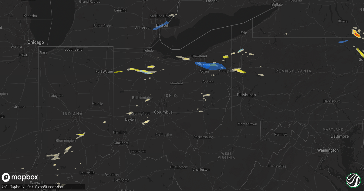
Hail Map in Ohio on June 1, 2022
Get this storm
June 1 map
$229
one time, instant access
Download today. No call, no setup
Keep the $229
Bought the map and want the full workflow? Apply the entire $229 to a subscription within 7 days. None of it is wasted.
Every map, not just this one
This buys you this map. Subscription and you get every map we run, in the markets you choose from a few cities to whole states to nationwide. Plus real-time alerts the moment a storm fires.
Contact data
Name, contact info, occupancy, even credit band for addresses in the footprint. You go from where it hit to who to call.
Become the source they trust
Unlimited branding weather history reports on demand. You already have the documented answer ready for the property owner, and you are the one who showed up with it.
Property data and RoofTrace estimates
Pull up any address you have got, its value and the exact code rules for that jurisdiction, straight from One Click Code. Then RoofTrace estimates the squares, pitch, and roof value, priced the way you price.
Storm reports in Ohio
Ohio
| Date | Description |
|---|---|
| 06/01/20226:52 PM CDT | Seneca county dispatch reports many trees down across big spring township. Time estimated via radar. |
| 06/01/20226:45 PM CDT | Tree down. Time estimated from radar. |
| 06/01/20226:45 PM CDT | Power lines were reported down in gnadenhutten |
| 06/01/20226:43 PM CDT | Tree down over harold road... North of jeffersonville. |
| 06/01/20226:42 PM CDT | Trees and power lines down. Time estimated from radar. |
| 06/01/20226:28 PM CDT | Trees down and blocking road at county road 236 and county road 212 northeast of findlay. Time estimated via radar. |
| 06/01/20226:26 PM CDT | Trees were reported down near the intersection of st route 416 and 259. |
| 06/01/20226:23 PM CDT | Tree snapped approx 10 feet up from the base in the area of township road 99 and county road 212 in findlay. Time estimated via radar. |
| 06/01/20226:15 PM CDT | Several utility poles down. Time estimated from radar. |
| 06/01/20226:12 PM CDT | Trained spotter reported several trees downed in mccomb. |
| 06/01/20226:12 PM CDT | Trained spotter reported quarter sized hail in mccomb. |
| 06/01/20226:04 PM CDT | Trees reported down on a house in hanoverton as well as a tree down just north of town. |
| 06/01/20226:00 PM CDT | Hancock county emergency manager reports several large trees down and roofs and siding blown off several trailers and barns in shawtown and extending over to mccomb. Ti |
| 06/01/20225:45 PM CDT | Tree and wires down. |
| 06/01/20225:45 PM CDT | Reports of multiple trees down on n sulphur springs road. Time estimated from 911 dispatch/radar. |
| 06/01/20225:44 PM CDT | Tree and wires down. Time estimated from radar. |
| 06/01/20225:43 PM CDT | Tree down. |
| 06/01/20225:31 PM CDT | Tree knocked down into yard. Time est from radar. |
| 06/01/20225:27 PM CDT | Delayed report - numerous trees down across warren. |
| 06/01/20225:27 PM CDT | Tree fell onto power lines in benton at intersection of state route 241 and county road 189. Time estimated via radar. |
| 06/01/20225:20 PM CDT | 6 inch diameter limb down. |
| 06/01/20225:18 PM CDT | Trumbull county dispatch reports widespread tree and power line damage across braceville. Time estimated via radar. |
| 06/01/20225:16 PM CDT | Trumbull county dispatch reports widespread tree and power line damage across newton falls. Time estimated via radar. |
| 06/01/20225:11 PM CDT | 5 large power transmission lines were snapped on road 82. An old barn on road 107 had the roof blown off and there were a few tree limbs broken at that location. There |
| 06/01/20224:58 PM CDT | Social media report of a pair of uprooted trees in shalersville twp. Time estimated via radar. |
| 06/01/20224:52 PM CDT | Tree and power lines down. |
| 06/01/20224:49 PM CDT | Multiple trees snapped off. |
| 06/01/20224:48 PM CDT | Spotter reports 70 mph wind gust and one inch hail in streetsboro. |
| 06/01/20224:48 PM CDT | Tree downed along route 83 just north of wooster. Time estimated via radar. |
| 06/01/20224:41 PM CDT | Estimated 55-60 mph wind gust. |
| 06/01/20224:37 PM CDT | Social media report of numerous trees down at hudson springs park. Time estimated via radar. |
| 06/01/20224:35 PM CDT | Delayed report - trees down in backyard. Tree split and fell on power line. |
| 06/01/20224:35 PM CDT | Delayed report - 1 inch hail. |
| 06/01/20224:29 PM CDT | Tree down on riverview road... South of everett. Time estimated via radar. |
| 06/01/20224:21 PM CDT | A local report indicates 60 MPH wind near 1 NNE NORTH ROYALTON |
| 06/01/20224:18 PM CDT | Corrects previous tstm wnd gst report from 1 nne north royalton. Corrected for time and source. |
| 06/01/20223:57 PM CDT | Morrow county emergency manager reports a roof blown off a trailer and a transformer fell onto another trailer on state route 97 near the richland county line. Time est |
| 06/01/20223:53 PM CDT | Tree down on house. |
| 06/01/20223:50 PM CDT | Report of trees and power lines down southeast of elyria. |
| 06/01/20223:49 PM CDT | Also one half inch hail. |
| 06/01/20223:42 PM CDT | Social media report of tree into power lines and a car on east river rd in sheffield village. Time estimated via radar. |
| 06/01/20223:33 PM CDT | Tree down on house. Time estimated from radar. |
| 06/01/20223:30 PM CDT | Two trees down on state route 171 |
| 06/01/20223:30 PM CDT | Two trees down on state route 171. Time estimated from radar. |
| 06/01/20223:19 PM CDT | Seneca county dispatch reports a few trees down in republic. Time estimated via radar. |
| 06/01/20222:50 PM CDT | Four power poles down on us route 6 and county rd 294. Person trapped in car in between poles. Person is not injured. Time estimated via radar. |
| 06/01/20222:41 PM CDT | Also estimated 60 mph wind. |
| 06/01/20222:27 PM CDT | Seneca county dispatch reports trees down on a building near tr 172 and cr 25 north of fostoria. Time estimated via radar. |
| 06/01/20222:25 PM CDT | Power lines downed on the north side of fostoria. Time estimated via radar. |
| 06/01/20221:56 PM CDT | Power pole down on gause rd. Between st. Anthony rd. And kuhn rd. |
| 06/01/20221:51 PM CDT | Several trees and large branches down. Also pea to dime size hail. |
| 06/01/20221:50 PM CDT | Social media picture showing several medium to large tree limbs downed. Time estimated via radar. |
| 06/01/202212:39 PM CDT | Two branches approximately 4 inches in diameter blown down on ohio state university main campus. Time estimated from radar. |
| 06/01/20223:21 AM CDT | At 821 PM EDT, a severe thunderstorm was located near Byesville, or near Cambridge, moving east at 40 mph. HAZARD...60 mph wind gusts. SOURCE...Radar indicated. IMPACT...Expect damage to trees and power lines, resulting in some power outages. Locations impacted include... Cambridge, Caldwell, New Concord, Byesville, Philo, Quaker City, Senecaville, Pleasant City, Cumberland, Lore City, Old Washington, and Summerfield. |
| 06/01/20223:02 AM CDT | At 802 PM EDT, a severe thunderstorm was located over Bloomville, or 10 miles southeast of Tiffin, moving east at 30 mph. HAZARD...60 mph wind gusts and quarter size hail. SOURCE...Radar indicated. IMPACT...Minor damage to vehicles is possible. Expect damage to trees and power lines. Locations impacted include... Mansfield, Shelby, Willard, New London, Plymouth, New Washington, Bloomville, Chatfield, Greenwich, Attica, Benton, Tiro, Shenandoah and Olivesburg. |
| 06/01/20222:34 AM CDT | At 733 PM EDT, a severe thunderstorm was located near Jeffersonville, moving east at 30 mph. HAZARD...60 mph wind gusts and quarter size hail. SOURCE...Radar indicated. IMPACT...Minor hail damage to vehicles is possible. Expect wind damage to trees and power lines. Locations impacted include... Jamestown, Mount Sterling, Jeffersonville, Bloomingburg, South Solon, Midway, Milledgeville, Octa, Chenoweth, Rosemoor, Madison Mills, Bookwalter, Bell Center, Shady Grove and Interstate 71 at US Route 35.This includes I-71 in Ohio between mile markers 61 and 85. |
| 06/01/20222:29 AM CDT | At 728 PM EDT, a severe thunderstorm was located near Uhrichsville, moving east at 35 mph. HAZARD...60 mph wind gusts and quarter size hail. SOURCE...Radar indicated. IMPACT...Minor hail damage to vehicles is possible. Expect wind damage to trees and power lines, resulting in some power outages. Locations impacted include... New Philadelphia, Uhrichsville, Cadiz, Dennison, Gnadenhutten, Tuscarawas, Scio, Midvale, Jewett, Bowerston, Barnhill, and Sherrodsville. |
| 06/01/20222:28 AM CDT | At 728 PM EDT, a severe thunderstorm was located near Findlay, moving east at 40 mph. HAZARD...70 mph wind gusts and ping pong ball size hail. SOURCE...Radar indicated. IMPACT...People and animals outdoors will be injured. Expect hail damage to roofs, siding, windows, and vehicles. Expect considerable tree damage. Wind damage is also likely to mobile homes, roofs, and outbuildings. Locations impacted include... Findlay, Tiffin, Fostoria, North Baltimore, Bloomville, Sycamore, Arcadia, Vanlue, Van Buren, New Riegel, Carey, Benton, Bloomdale, Republic, Bairdstown and Bascom. |
| 06/01/20222:21 AM CDT | At 720 PM EDT, a severe thunderstorm was located near Connersville, moving east at 25 mph. HAZARD...60 mph wind gusts and quarter size hail. SOURCE...Radar indicated. IMPACT...Minor hail damage to vehicles is possible. Expect wind damage to trees and power lines. Locations impacted include... Richmond, Connersville, Centerville, Liberty, Salem, Waterloo, Bunker Hill, Abington, Brownsville, Boston, Richmond Municipal Airport, Witts Station, Dunlapsville, Alquina, Whitewater State Park, Goodwins Corner, Mettel Field, Cottage Grove, Clifton and Kitchel.This includes the following Interstates... I-70 in Indiana between mile markers 155 and 156. I-70 in Ohio near mile marker 0. |
| 06/01/20222:05 AM CDT | At 705 PM EDT, a severe thunderstorm was located near Tipp City, moving northeast at 50 mph. HAZARD...60 mph wind gusts and nickel size hail. SOURCE...Radar indicated. IMPACT...Expect damage to trees and power lines. Locations impacted include... Dayton, Springfield, Huber Heights, Troy, Vandalia, Urbana, Tipp City, New Carlisle, Northridge, Enon, Brown, Riverside, Union, Christiansburg, North Hampton, Tremont City, Donnelsville, Casstown, Ginghamsburg and Thackery.This includes the following Interstates... I-70 in Ohio between mile markers 31 and 51. I-75 in Ohio between mile markers 57 and 71. |
| 06/01/20221:58 AM CDT | At 658 PM EDT, a severe thunderstorm was located over Sugarcreek, or 8 miles west of Dover, moving east at 30 mph. HAZARD...60 mph wind gusts and penny size hail. SOURCE...Radar indicated. IMPACT...Expect damage to trees and power lines, resulting in some power outages. Locations impacted include... New Philadelphia, Dover, Uhrichsville, Dennison, Sugarcreek, Gnadenhutten, Tuscarawas, Baltic, Midvale, Port Washington, Barnhill, and Roswell. |
| 06/01/20221:55 AM CDT | At 654 PM EDT, a severe thunderstorm was located near Leipsic, or 8 miles north of Ottawa, moving east at 40 mph. HAZARD...60 mph wind gusts and quarter size hail. SOURCE...Radar indicated. IMPACT...Minor damage to vehicles is possible. Expect damage to trees and power lines. Locations impacted include... Findlay, North Baltimore, McComb, Van Buren, Bloomdale, Cygnet, Portage, Jerry City, Hoytville, Benton Ridge, Custar, Milton Center and Bairdstown. |
| 06/01/20221:54 AM CDT | At 653 PM EDT, a severe thunderstorm was located near Leipsic, or 8 miles north of Ottawa, moving east at 40 mph. HAZARD...60 mph wind gusts and half dollar size hail. SOURCE...Radar indicated. IMPACT...Hail damage to vehicles is expected. Expect wind damage to roofs, siding, and trees. Locations impacted include... Ottawa, Leipsic, Deshler, Holgate, Glandorf, Hamler, West Leipsic, Gilboa, Belmore, Miller City, New Bavaria, Prentiss, Gallup and Elery. |
| 06/01/20221:26 AM CDT | At 625 PM EDT, a severe thunderstorm was located 7 miles southeast of Paulding, or 14 miles south of Defiance, moving east at 45 mph. HAZARD...60 mph wind gusts and quarter size hail. SOURCE...Radar indicated. IMPACT...Hail damage to vehicles is expected. Expect wind damage to roofs, siding, and trees. Locations impacted include... Ottawa, Leipsic, Deshler, Kalida, Continental, Holgate, Glandorf, Oakwood, Hamler, Dupont, Malinta, West Leipsic, Gilboa, Cloverdale, Belmore, Miller City, New Bavaria, Arthur, Ayersville and Wisterman. |
| 06/01/20221:24 AM CDT | At 624 PM EDT, severe thunderstorms were located along a line extending from near Hartville to near Louisville to Brewster, moving east at 30 mph. HAZARD...60 mph wind gusts and penny size hail. SOURCE...Radar indicated. IMPACT...Expect damage to trees and power lines. Locations impacted include... Canton, Salem, Columbiana, Alliance, Louisville, Sebring, Minerva, Hartville, Waynesburg, East Sparta, Randolph, Atwater, East Canton, Beloit, Deerfield, Limaville, Robertsville, Maple Ridge, Maximo and Greenford. |
| 06/01/20221:19 AM CDT | At 619 PM EDT, a severe thunderstorm was located near Berlin, or 8 miles northeast of Millersburg, moving east at 35 mph. HAZARD...60 mph wind gusts and penny size hail. SOURCE...Radar indicated. IMPACT...Expect damage to trees and power lines. Locations impacted include... Millersburg, Berlin, Walnut Creek, Brewster, Navarre, Wilmot, Mount Eaton, Winesburg, Beach City, Bolivar, Fredericksburg and Mount Hope. |
| 06/01/20221:11 AM CDT | At 611 PM EDT, a severe thunderstorm was located over Greenville, or 11 miles northeast of Sharpsville, moving east at 25 mph. HAZARD...60 mph wind gusts and nickel size hail. SOURCE...Radar indicated. IMPACT...Expect damage to trees and power lines, resulting in some power outages. Locations impacted include... Hermitage, Sharon, Grove City, Franklin, Sharpsville, Greenville, Sugarcreek, Farrell, Mercer, Stoneboro, West Middlesex, and Polk. |
| 06/01/20221:08 AM CDT | At 607 PM EDT, a severe thunderstorm was located over Pymatuning Central, or 17 miles west of Meadville, moving east at 30 mph. HAZARD...60 mph wind gusts and quarter size hail. SOURCE...Radar indicated. IMPACT...Minor damage to vehicles is possible. Expect damage to trees and power lines. Locations impacted include... Meadville, Titusville, Linesville, Harmonsburg, Adamsville, Guys Mills, Pymatuning Central, Atlantic, Pymatuning North, Cochranton, Conneaut Lake, Jamestown, Hydetown, Blooming Valley, Townville, Conneaut Lakeshore, Geneva and Hartstown. |
| 06/01/20221:08 AM CDT | At 607 PM EDT, a severe thunderstorm was located over Tipp City, moving east at 25 mph. HAZARD...60 mph wind gusts and penny size hail. SOURCE...Radar indicated. IMPACT...Expect damage to trees and power lines. Locations impacted include... Springfield, Huber Heights, Vandalia, Englewood, Tipp City, New Carlisle, Northridge, Enon, Brown, Union, Christiansburg, North Hampton, Tremont City, Donnelsville, Green Meadows, Ginghamsburg, Thackery, Phoneton and Terre Haute.This includes the following Interstates... I-70 in Ohio between mile markers 30 and 42, and between milemarkers 45 and 56. I-75 in Ohio between mile markers 62 and 71. |
| 06/01/20221:04 AM CDT | At 604 PM EDT, a severe thunderstorm was located over Payne, or 15 miles northwest of Van Wert, moving east at 35 mph. HAZARD...60 mph wind gusts and quarter size hail. SOURCE...Radar indicated. IMPACT...Hail damage to vehicles is expected. Expect wind damage to roofs, siding, and trees. Locations impacted include... Paulding, Payne, Oakwood, Grover Hill, Dupont, Scott, Melrose, Haviland, Latty, Cloverdale, Broughton, Worstville, Arthur, Charloe, Tipton, Roselms, Mandale and Briceton. |
| 06/01/20221:03 AM CDT | At 602 PM EDT, a severe thunderstorm was located over Garrettsville, or 13 miles northeast of Ravenna, moving east at 30 mph. HAZARD...60 mph wind gusts and quarter size hail. SOURCE...Radar indicated. IMPACT...Minor damage to vehicles is possible. Expect damage to trees and power lines. Locations impacted include... Warren, Cortland, Garrettsville, Kinsman, West Farmington, Bristolville, Vienna Center, Leavittsburg, Girard, Parkman, Vienna, Mecca, Johnston, Hiram, Orangeville, Yankee Lake, Brookfield Center, Howland Center, West Hill and Champion Heights. |
| 06/01/202212:54 AM CDT | At 554 PM EDT, a severe thunderstorm was located near Ravenna, moving east at 45 mph. HAZARD...70 mph wind gusts and quarter size hail. SOURCE...Radar indicated. IMPACT...Minor damage to vehicles is possible. Expect considerable tree damage. Wind damage is also likely to mobile homes, roofs, and outbuildings. Locations impacted include... Youngstown, Warren, Ravenna, Boardman, Kent, Niles, Streetsboro, Campbell, Hubbard, Canfield, Newton Falls, Lordstown, Garrettsville, Mantua, Vienna Center, Hilltop, Maplewood Park, Leavittsburg, Austintown and Aurora. |
| 06/01/202212:50 AM CDT | At 550 PM EDT, severe thunderstorms were located along a line extending from near Chippewa Lake to near Orrville to near Shreve, moving east at 25 mph. HAZARD...60 mph wind gusts and penny size hail. SOURCE...Radar indicated. IMPACT...Expect damage to trees and power lines. Locations impacted include... Canton, Wooster, Massillon, Barberton, Green, North Canton, Orrville, Rittman, Doylestown, Hartville, Creston, Brewster, Navarre, Dalton, Shreve, New Franklin, Norton, Canal Fulton, Smithville and Clinton. |
| 06/01/202212:35 AM CDT | At 534 PM EDT, a severe thunderstorm was located near Greenville, or 9 miles north of Sharpsville, moving east at 45 mph. HAZARD...60 mph wind gusts and nickel size hail. SOURCE...Radar indicated. IMPACT...Expect damage to trees and power lines, resulting in some power outages. Locations impacted include... Hermitage, Greenville, Stoneboro, Sandy Lake, Clark, Jamestown, Fredonia, Sheakleyville, and Maurice K Goddard State Park. |
| 06/01/202212:28 AM CDT | At 528 PM EDT, a severe thunderstorm was located 9 miles south of Carrollton, moving east at 25 mph. HAZARD...60 mph wind gusts and quarter size hail. SOURCE...Radar indicated. IMPACT...Minor hail damage to vehicles is possible. Expect wind damage to trees and power lines, resulting in some power outages. Locations impacted include... Scio, Bergholz, Amsterdam, Harlem Springs, and Kilgore. |
| 06/01/202212:22 AM CDT | At 522 PM EDT, a severe thunderstorm was located near North Royalton, or 13 miles south of Cleveland, moving east at 40 mph. HAZARD...60 mph wind gusts and quarter size hail. SOURCE...Radar indicated. IMPACT...Minor damage to vehicles is possible. Expect damage to trees and power lines. Locations impacted include... Cleveland, Akron, Ravenna, Parma, Cuyahoga Falls, Strongsville, Brunswick, North Royalton, Kent, Solon, Hudson, Twinsburg, Tallmadge, Streetsboro, Warrensville Heights, Macedonia, South Russell, Garrettsville, Mantua and Stow. |
| 05/31/202211:40 PM CDT | At 440 PM EDT, a severe thunderstorm was located over Lorain, moving east at 40 mph. HAZARD...70 mph wind gusts and penny size hail. SOURCE...Radar indicated. IMPACT...Expect considerable tree damage. Damage is likely to mobile homes, roofs, and outbuildings. Locations impacted include... Cleveland, Lorain, Elyria, Parma, Lakewood, Strongsville, Brunswick, Westlake, North Royalton, North Ridgeville, Avon Lake, Amherst, Grafton, North Olmsted, Garfield Heights, Avon, Parma Heights, Rocky River, Broadview Heights and Brook Park. |
| 05/31/202211:23 PM CDT | At 423 PM EDT, a severe thunderstorm was located near Carrollton, moving east at 40 mph. HAZARD...60 mph wind gusts and quarter size hail. SOURCE...Radar indicated. IMPACT...Minor hail damage to vehicles is possible. Expect wind damage to trees and power lines, resulting in some power outages. Locations impacted include... Carrollton, Wintersville, Salineville, Bergholz, Amsterdam, Richmond, Irondale, Dellroy, Sherrodsville, Hammondsville, Mechanicstown, and Kilgore. |
| 05/31/202211:17 PM CDT | At 417 PM EDT, a severe thunderstorm was located 9 miles northwest of Western Vermilion, moving east at 25 mph. HAZARD...60 mph wind gusts and quarter size hail. SOURCE...Radar indicated. IMPACT...Minor damage to vehicles is possible. Expect damage to trees and power lines. Locations impacted include... Lorain, Elyria, Western Vermilion, Vermilion, North Ridgeville, Avon Lake, Amherst, Grafton, Avon, Bay Village, Sheffield Lake, Eaton, Sheffield, South Amherst and Eaton Estates. |
| 05/31/202211:08 PM CDT | At 408 PM EDT, severe thunderstorms were located along a line extending from 6 miles south of Green Springs to near Sycamore to Dunkirk, moving east at 20 mph. HAZARD...60 mph wind gusts and penny size hail. SOURCE...Radar indicated. IMPACT...Expect damage to trees and power lines. Locations impacted include... Tiffin, Upper Sandusky, Willard, Forest, New Washington, Bloomville, Sycamore, New Riegel, Chatfield, Carey, Attica, Benton, Nevada, Republic, Wharton, Kirby and Oceola. |
| 05/31/202210:17 PM CDT | At 317 PM EDT, a severe thunderstorm was located near Fostoria, moving east at 25 mph. HAZARD...60 mph wind gusts and quarter size hail. SOURCE...Radar indicated. IMPACT...Minor damage to vehicles is possible. Expect damage to trees and power lines. Locations impacted include... Tiffin, Fremont, Fostoria, Clyde, Green Springs, Ballville, Wayne, Bloomdale, Bettsville, Risingsun, Republic, West Millgrove, Burgoon, Kansas and Stony Prairie. |
| 05/31/20227:40 PM CDT | Report of a few trees and power lines down around mingo junction |
| 05/31/20227:39 PM CDT | Dispatch reported trees and power lines down near pleasant city. |
| 05/31/20227:36 PM CDT | Fire department reports several electrical poles downed across state route 96 east of shelby between plymouth-springmill road and industrial tech parkway. Time estimate |
| 05/31/20227:33 PM CDT | Fire department reports several electrical poles downed across the road north of shelby. Time estimated via radar. |
| 05/31/20227:09 PM CDT | Trees and power lines down |
| 05/31/20227:07 PM CDT | Seneca county dispatch reports many trees down across venice township. Time estimated via radar. |
| 05/31/20227:00 PM CDT | Large tree limb downed on miller road just south of the seneca/crawford county line. Time estimated via radar. |
All States Impacted by Hail Map on June 1, 2022
Cities Impacted by Hail Map on June 1, 2022
- Factoryville, PA
- Fleetville, PA
- Nicholson, PA
- Jamestown, OH
- Harsens Island, MI
- Marysville, OH
- Raymond, OH
- Zanesfield, OH
- East Liberty, OH
- West Liberty, OH
- Blairstown, NJ
- Great Meadows, NJ
- Stanton, TN
- Algonac, MI
- Limaville, OH
- Alliance, OH
- Atwater, OH
- Bells, TN
- London, OH
- Marion, AR
- Vermilion, OH
- Sheffield Lake, OH
- North Ridgeville, OH
- Avon, OH
- Amherst, OH
- Lorain, OH
- Elyria, OH
- Blytheville, AR
- Pataskala, OH
- Sayre, OK
- Eddyville, KY
- Fredonia, KY
- Dubois, IN
- Loogootee, IN
- Jasper, IN
- Weatherford, OK
- Paulding, OH
- Haviland, OH
- Morganfield, KY
- Sturgis, KY
- Cabot, AR
- Austin, AR
- Somerville, TN
- Williston, TN
- Allegany, NY
- Alamo, TN
- Halls, TN
- Friendship, TN
- Oil City, PA
- Cooperstown, PA
- Titusville, PA
- Letona, AR
- Searcy, AR
- Tiffin, OH
- Harrison, AR
- Mount Blanchard, OH
- Carey, OH
- Wharton, OH
- Great Bend, PA
- Hallstead, PA
- Susquehanna, PA
- Dyersburg, TN
- Oak Harbor, OH
- Aubrey, TX
- Little Elm, TX
- Wheeler, TX
- Ellery, IL
- Albion, IL
- Walnut Ridge, AR
- Cash, AR
- Leedey, OK
- Endicott, NY
- Conklin, NY
- Newark Valley, NY
- Vestal, NY
- Johnson City, NY
- Brackney, PA
- Maine, NY
- Binghamton, NY
- Owego, NY
- Omaha, AR
- Byesville, OH
- New Concord, OH
- Cambridge, OH
- Herod, IL
- Judsonia, AR
- Foster, OK
- Elmore City, OK
- Stamford, TX
- Ethel, AR
- De Witt, AR
- Saint Charles, AR
- Altus, AR
- Clarksville, AR
- Hartman, AR
- Harpursville, NY
- Windsor, NY
- Bald Knob, AR
- Cochranton, PA
- Pampa, TX
- Saint Meinrad, IN
- Mitchell, IN
- Sugarcreek, OH
- New Philadelphia, OH
- Mclean, TX
- Shamrock, TX
- Mobeetie, TX
- Arlington, TN
- Watonga, OK
- Panhandle, TX
- Lynn, AR
- Smithville, AR
- Bristolville, OH
- Cortland, OH
- Marion, KY
- Shippenville, PA
- Lone Wolf, OK
- Granite, OK
- Willow, OK
- Carter, OK
- Anna, IL
- Jonesboro, IL
- Cobden, IL
- Slippery Rock, PA
- Mercer, PA
- Pulaski, PA
- West Middlesex, PA
- Grove City, PA
- Volant, PA
- New Castle, PA
- New Wilmington, PA
- Republic, OH
- Elizabethtown, IL
- Kenton, TN
- Mount Sidney, VA
- Fort Defiance, VA
- Salem, KY
- Farmdale, OH
- Orwell, OH
- North Bloomfield, OH
- Williamsfield, OH
- Kinsman, OH
- Kingston, AR
- Paris, AR
- Connersville, IN
- Bedford, VA
- Taloga, OK
- Putnam, OK
- Medway, OH
- Lockesburg, AR
- Nashville, AR
- Warren, OH
- Forest, OH
- Arlington, OH
- Fostoria, OH
- Kansas, OH
- Bloomdale, OH
- Risingsun, OH
- Floyds Knobs, IN
- Borden, IN
- Norman, IN
- Bedford, IN
- Port Washington, OH
- Newcomerstown, OH
- Gnadenhutten, OH
- Marked Tree, AR
- Marion, IL
- Carbondale, IL
- Lueders, TX
- Hodgen, OK
- West Mansfield, OH
- Richwood, OH
- Clarendon, TX
- Avoca, IN
- Williams, IN
- Heltonville, IN
- Oolitic, IN
- Finley, TN
- Thompson, PA
- Jackson, PA
- Arapaho, OK
- Butler, OK
- Clinton, OK
- North Lewisburg, OH
- Woodstock, OH
- Utica, PA
- Laceyville, PA
- Lawton, PA
- Montrose, PA
- Guys Mills, PA
- New Bethlehem, PA
- Templeton, PA
- Rimersburg, PA
- Scott City, MO
- Cape Girardeau, MO
- McClure, IL
- Uhrichsville, OH
- Midvale, OH
- Dennison, OH
- Nineveh, IN
- Trafalgar, IN
- Jamestown, PA
- Andover, OH
- Linesville, PA
- Hartstown, PA
- Zanesville, OH
- Hardinsburg, KY
- Rome, IN
- Hawesville, KY
- Cannelton, IN
- Union Dale, PA
- Chenango Forks, NY
- Castle Creek, NY
- Springville, PA
- Meshoppen, PA
- Scranton, PA
- Waverly, PA
- Moscow, PA
- Tunkhannock, PA
- Dalton, PA
- Clarks Summit, PA
- Olyphant, PA
- Swifton, AR
- Danville, AR
- Waldron, AR
- Haskell, TX
- Biscoe, AR
- Des Arc, AR
- Seminole, TX
- Friona, TX
- Floydada, TX
- Matador, TX
- Throckmorton, TX
- Newcastle, TX
- Stuttgart, AR
- Almyra, AR
- Carbon, TX
- Rising Star, TX
- Stanton, TX
- Argyle, TX
- Fort Lauderdale, FL
- Clarendon, AR
- Holly Grove, AR
- Dresden, TN
- Palmersville, TN
- Dukedom, TN
- Lake Dallas, TX
- Mentone, TX
- Seymour, TX
- Heth, AR
- Naples, FL
- Bonita Springs, FL
- Canyon, TX
- Happy, TX
- Claude, TX
- Santa Anna, TX
- Carnegie, OK
- Cordell, OK
- Alvada, OH
- Arcadia, OH
- McComb, OH
- Findlay, OH
- Quitaque, TX
- Turkey, TX
- Ballinger, TX
- Rowena, TX
- Miles, TX
- Quail, TX
- Wellington, TX
- Valentine, TX
- Fort Davis, TX
- Pecos, TX
- Balmorhea, TX
- Paint Rock, TX
- Lockney, TX
- Kress, TX
- Silverton, TX
- Tulia, TX
- Andrews, TX
- Goldsmith, TX
- Hobbs, NM
- Lovington, NM
- Comanche, TX
- Brownsville, TN
- Garden City, TX
- Corn, OK
- Colony, OK
- Hydro, OK
- Snyder, TX
- Hermleigh, TX
- Decatur, TX
- Mullin, TX
- Leipsic, OH
- Bangs, TX
- Hollis, OK
- Midland, TX
- South Solon, OH
- Jeffersonville, OH
- Marlow, OK
- Duncan, OK
- Mellwood, AR
- Ozark, AR
- Brecksville, OH
- North Royalton, OH
- Broadview Heights, OH
- Peninsula, OH
- Hinckley, OH
- Richfield, OH
- Jal, NM
- Electra, TX
- Holliday, TX
- Tyronza, AR
- Meadville, PA
- Conneaut Lake, PA
- West Helena, AR
- Helena, AR
- Justin, TX
- Rhome, TX
- Pilot Point, TX
- Eden, TX
- Millersview, TX
- Menard, TX
- Olney, TX
- Woodson, TX
- Albany, TX
- Breckenridge, TX
- Brownwood, TX
- Del Rio, TX
- Moran, TX
- Bono, AR
- The Colony, TX
- Flomot, TX
- Abilene, TX
- Baird, TX
- Vandalia, OH
- Tipp City, OH
- Crowell, TX
- Haughton, LA
- Princeton, LA
- Maljamar, NM
- Marathon, TX
- Dodson, TX
- Englewood, OH
- West Milton, OH
- Alpine, TX
- Continental, OH
- New Riegel, OH
- New Bavaria, OH
- Mason, TN
- Pep, NM
- Roswell, NM
- Elida, NM
- Freeport, OH
- Durant, OK
- Washington, IN
- Odon, IN
- Cannelburg, IN
- Crane, IN
- Shoals, IN
- Plainville, IN
- Montgomery, IN
- Avoca, TX
- Dimmitt, TX
- Hereford, TX
- Irving, TX
- Flower Mound, TX
- Lewisville, TX
- Coppell, TX
- Grapevine, TX
- Southlake, TX
- Frisco, TX
- Arthur City, TX
- Sumner, TX
- Telephone, TX
- Miami, FL
- Eola, TX
- Kermit, TX
- Gunnison, MS
- Centerville, TX
- Edinburgh, IN
- Columbus, IN
- Hartville, OH
- Canton, OK
- Oakwood, OK
- Wynnewood, OK
- Newbern, TN
- Cisco, TX
- Voss, TX
- Brookland, AR
- Jonesboro, AR
- Tutwiler, MS
- Gouldbusk, TX
- Saint Paris, OH
- Pekin, IN
- Drasco, AR
- Whitney Point, NY
- Berkshire, NY
- Lisle, NY
- Glen Aubrey, NY
- Ravenna, OH
- Newton Falls, OH
- Garrettsville, OH
- Windham, OH
- Green Forest, AR
- Davis, OK
- Crawfordsville, AR
- Plano, TX
- Roanoke, TX
- Tunica, MS
- Marianna, AR
- Smithville, OK
- Heavener, OK
- Steele, MO
- Strong, AR
- Huttig, AR
- Tyler, TX
- Arp, TX
- Vancourt, TX
- Briscoe, TX
- Memphis, TX
- Mangum, OK
- Early, TX
- Deport, TX
- Winters, TX
- Rochelle, TX
- Odessa, TX
- Rockwood, TX
- Bell City, MO
- Oran, MO
- Benton, MO
- Cave In Rock, IL
- Mead, OK
- Caddo, OK
- Calera, OK
- Saint Anthony, IN
- Huntingburg, IN
- Schnellville, IN
- Malvern, PA
- Wayne, PA
- Phoenixville, PA
- Gilmore, AR
- Turrell, AR
- Bluffton, AR
- Gravelly, AR
- Tatum, NM
- Canadian, TX
- Mantua, OH
- Northfield, OH
- Hudson, OH
- Streetsboro, OH
- Coleman, TX
- Lepanto, AR
- Ripley, TN
- Flat Rock, IN
- Taylorsville, IN
- Hope, IN
- Nashville, IN
- Thomas, OK
- Joiner, AR
- Wilson, AR
- Hiram, OH
- Depauw, IN
- Rockport, IN
- Booneville, AR
- Aledo, TX
- Magazine, AR
- Mayflower, AR
- Conway, AR
- Bigelow, AR
- Gardendale, TX
- West Monroe, LA
- Martin, TN
- South Fulton, TN
- Brookesmith, TX
- Lewisport, KY
- Tell City, IN
- Summerville, SC
- Gorman, TX
- Ponder, TX
- Payne, OH
- Charleston, MO
- Miller City, IL
- Barlow, KY
- Villa Ridge, IL
- Mound City, IL
- Mounds, IL
- Olmsted, IL
- Cairo, IL
- Thebes, IL
- Loving, NM
- Milan, PA
- Ulster, PA
- East Smithfield, PA
- Athens, PA
- Rome, PA
- Van Horn, TX
- Wink, TX
- Ranger, TX
- Eastland, TX
- Latty, OH
- Saegertown, PA
- Diamond, OH
- Niles, OH
- Strongsville, OH
- Brunswick, OH
- Twinsburg, OH
- Stow, OH
- Mineral Ridge, OH
- Leavittsburg, OH
- Aurora, OH
- Kent, OH
- McDonald, OH
- Southington, OH
- Macedonia, OH
- Cuyahoga Falls, OH
- Grosse Pointe, MI
- Taylor, MI
- Dearborn, MI
- Allen Park, MI
- Southgate, MI
- Romulus, MI
- Dearborn Heights, MI
- Ecorse, MI
- Lincoln Park, MI
- River Rouge, MI
- Detroit, MI
- Melvindale, MI


