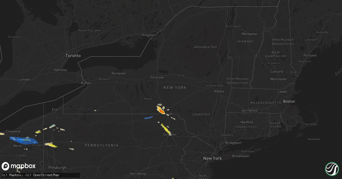
Hail Map in New York on June 1, 2022
Get this storm
June 1 map
$229
one time, instant access
Download today. No call, no setup
Keep the $229
Bought the map and want the full workflow? Apply the entire $229 to a subscription within 7 days. None of it is wasted.
Every map, not just this one
This buys you this map. Subscription and you get every map we run, in the markets you choose from a few cities to whole states to nationwide. Plus real-time alerts the moment a storm fires.
Contact data
Name, contact info, occupancy, even credit band for addresses in the footprint. You go from where it hit to who to call.
Become the source they trust
Unlimited branding weather history reports on demand. You already have the documented answer ready for the property owner, and you are the one who showed up with it.
Property data and RoofTrace estimates
Pull up any address you have got, its value and the exact code rules for that jurisdiction, straight from One Click Code. Then RoofTrace estimates the squares, pitch, and roof value, priced the way you price.
Storm reports in New York
New York
| Date | Description |
|---|---|
| 06/01/20222:59 PM CDT | Photo of estimated golf ball size hail relayed via social media. Time estimated by radar. |
| 06/01/20222:55 PM CDT | Pea to quarter size hail south side of binghamton. |
| 06/01/20222:55 PM CDT | Vestal near intersection of murray hill road and washington drive. Multiple trees down in yards. |
| 06/01/20222:50 PM CDT | A local report indicates 3.00 inch wind near VESTAL |
| 06/01/20222:50 PM CDT | A local report indicates 1.25 inch wind near VESTAL |
| 06/01/20222:50 PM CDT | Corrects previous hail report location from vestal. |
| 06/01/20222:50 PM CDT | Photos of several trees uprooted and down. Sporadic damage. |
| 06/01/20222:50 PM CDT | A local report indicates 1.75 inch wind near 2 SE ENDWELL |
| 06/01/20222:49 PM CDT | Large tree down in backyard. |
| 06/01/20222:45 PM CDT | Tree down blocking roadway. |
| 06/01/20222:45 PM CDT | A local report indicates 1.00 inch wind near 3 SW BINGHAMTON |
| 06/01/20222:44 PM CDT | A local report indicates 2.00 inch wind near 1 W ENDWELL |
| 06/01/20222:43 PM CDT | Report from mping: ping pong ball |
| 06/01/20222:43 PM CDT | At least golf ball size hail. |
| 06/01/20222:42 PM CDT | A local report indicates 1.00 inch wind near 1 N ENDWELL |
| 06/01/20222:38 PM CDT | Tree down on a house on university avenue. |
| 06/01/20222:38 PM CDT | Corrects previous tstm wnd dmg report from endwell. Very large tree uprooted that fell on a car and a house on university avenue. |
| 06/01/20222:37 PM CDT | Tree down on a vehicle. |
| 06/01/20222:37 PM CDT | A local report indicates 1.00 inch wind near 1 NE WEST CORNERS |
| 06/01/20221:43 AM CDT | At 642 PM EDT, a severe thunderstorm was located over Milan, or near Athens, moving east at 40 mph. HAZARD...60 mph wind gusts and quarter size hail. SOURCE...Radar indicated. IMPACT...Hail damage to vehicles is expected. Expect wind damage to roofs, siding, and trees. Locations impacted include... Sayre, Athens, Sheshequin, Ulster, Litchfield, Orwell, Windham, Nichols, Rome and Le Raysville. |
| 05/31/20228:39 PM CDT | At 139 PM EDT, a severe thunderstorm was located over Thompson, or 15 miles south of Deposit, moving southeast at 25 mph. HAZARD...60 mph wind gusts and quarter size hail. SOURCE...Radar indicated. IMPACT...Hail damage to vehicles is expected. Expect wind damage to roofs, siding, and trees. Locations impacted include... Ararat, Lanesboro, Thompson, Union Dale, Starrucca, Hiawatha, Shehawken, Starlight, Starruca and Pleasant Mount. |
All States Impacted by Hail Map on June 1, 2022
Cities Impacted by Hail Map on June 1, 2022
- Factoryville, PA
- Fleetville, PA
- Nicholson, PA
- Jamestown, OH
- Harsens Island, MI
- Marysville, OH
- Raymond, OH
- Zanesfield, OH
- East Liberty, OH
- West Liberty, OH
- Blairstown, NJ
- Great Meadows, NJ
- Stanton, TN
- Algonac, MI
- Limaville, OH
- Alliance, OH
- Atwater, OH
- Bells, TN
- London, OH
- Marion, AR
- Vermilion, OH
- Sheffield Lake, OH
- North Ridgeville, OH
- Avon, OH
- Amherst, OH
- Lorain, OH
- Elyria, OH
- Blytheville, AR
- Pataskala, OH
- Sayre, OK
- Eddyville, KY
- Fredonia, KY
- Dubois, IN
- Loogootee, IN
- Jasper, IN
- Weatherford, OK
- Paulding, OH
- Haviland, OH
- Morganfield, KY
- Sturgis, KY
- Cabot, AR
- Austin, AR
- Somerville, TN
- Williston, TN
- Allegany, NY
- Alamo, TN
- Halls, TN
- Friendship, TN
- Oil City, PA
- Cooperstown, PA
- Titusville, PA
- Letona, AR
- Searcy, AR
- Tiffin, OH
- Harrison, AR
- Mount Blanchard, OH
- Carey, OH
- Wharton, OH
- Great Bend, PA
- Hallstead, PA
- Susquehanna, PA
- Dyersburg, TN
- Oak Harbor, OH
- Aubrey, TX
- Little Elm, TX
- Wheeler, TX
- Ellery, IL
- Albion, IL
- Walnut Ridge, AR
- Cash, AR
- Leedey, OK
- Endicott, NY
- Conklin, NY
- Newark Valley, NY
- Vestal, NY
- Johnson City, NY
- Brackney, PA
- Maine, NY
- Binghamton, NY
- Owego, NY
- Omaha, AR
- Byesville, OH
- New Concord, OH
- Cambridge, OH
- Herod, IL
- Judsonia, AR
- Foster, OK
- Elmore City, OK
- Stamford, TX
- Ethel, AR
- De Witt, AR
- Saint Charles, AR
- Altus, AR
- Clarksville, AR
- Hartman, AR
- Harpursville, NY
- Windsor, NY
- Bald Knob, AR
- Cochranton, PA
- Pampa, TX
- Saint Meinrad, IN
- Mitchell, IN
- Sugarcreek, OH
- New Philadelphia, OH
- Mclean, TX
- Shamrock, TX
- Mobeetie, TX
- Arlington, TN
- Watonga, OK
- Panhandle, TX
- Lynn, AR
- Smithville, AR
- Bristolville, OH
- Cortland, OH
- Marion, KY
- Shippenville, PA
- Lone Wolf, OK
- Granite, OK
- Willow, OK
- Carter, OK
- Anna, IL
- Jonesboro, IL
- Cobden, IL
- Slippery Rock, PA
- Mercer, PA
- Pulaski, PA
- West Middlesex, PA
- Grove City, PA
- Volant, PA
- New Castle, PA
- New Wilmington, PA
- Republic, OH
- Elizabethtown, IL
- Kenton, TN
- Mount Sidney, VA
- Fort Defiance, VA
- Salem, KY
- Farmdale, OH
- Orwell, OH
- North Bloomfield, OH
- Williamsfield, OH
- Kinsman, OH
- Kingston, AR
- Paris, AR
- Connersville, IN
- Bedford, VA
- Taloga, OK
- Putnam, OK
- Medway, OH
- Lockesburg, AR
- Nashville, AR
- Warren, OH
- Forest, OH
- Arlington, OH
- Fostoria, OH
- Kansas, OH
- Bloomdale, OH
- Risingsun, OH
- Floyds Knobs, IN
- Borden, IN
- Norman, IN
- Bedford, IN
- Port Washington, OH
- Newcomerstown, OH
- Gnadenhutten, OH
- Marked Tree, AR
- Marion, IL
- Carbondale, IL
- Lueders, TX
- Hodgen, OK
- West Mansfield, OH
- Richwood, OH
- Clarendon, TX
- Avoca, IN
- Williams, IN
- Heltonville, IN
- Oolitic, IN
- Finley, TN
- Thompson, PA
- Jackson, PA
- Arapaho, OK
- Butler, OK
- Clinton, OK
- North Lewisburg, OH
- Woodstock, OH
- Utica, PA
- Laceyville, PA
- Lawton, PA
- Montrose, PA
- Guys Mills, PA
- New Bethlehem, PA
- Templeton, PA
- Rimersburg, PA
- Scott City, MO
- Cape Girardeau, MO
- McClure, IL
- Uhrichsville, OH
- Midvale, OH
- Dennison, OH
- Nineveh, IN
- Trafalgar, IN
- Jamestown, PA
- Andover, OH
- Linesville, PA
- Hartstown, PA
- Zanesville, OH
- Hardinsburg, KY
- Rome, IN
- Hawesville, KY
- Cannelton, IN
- Union Dale, PA
- Chenango Forks, NY
- Castle Creek, NY
- Springville, PA
- Meshoppen, PA
- Scranton, PA
- Waverly, PA
- Moscow, PA
- Tunkhannock, PA
- Dalton, PA
- Clarks Summit, PA
- Olyphant, PA
- Swifton, AR
- Danville, AR
- Waldron, AR
- Haskell, TX
- Biscoe, AR
- Des Arc, AR
- Seminole, TX
- Friona, TX
- Floydada, TX
- Matador, TX
- Throckmorton, TX
- Newcastle, TX
- Stuttgart, AR
- Almyra, AR
- Carbon, TX
- Rising Star, TX
- Stanton, TX
- Argyle, TX
- Fort Lauderdale, FL
- Clarendon, AR
- Holly Grove, AR
- Dresden, TN
- Palmersville, TN
- Dukedom, TN
- Lake Dallas, TX
- Mentone, TX
- Seymour, TX
- Heth, AR
- Naples, FL
- Bonita Springs, FL
- Canyon, TX
- Happy, TX
- Claude, TX
- Santa Anna, TX
- Carnegie, OK
- Cordell, OK
- Alvada, OH
- Arcadia, OH
- McComb, OH
- Findlay, OH
- Quitaque, TX
- Turkey, TX
- Ballinger, TX
- Rowena, TX
- Miles, TX
- Quail, TX
- Wellington, TX
- Valentine, TX
- Fort Davis, TX
- Pecos, TX
- Balmorhea, TX
- Paint Rock, TX
- Lockney, TX
- Kress, TX
- Silverton, TX
- Tulia, TX
- Andrews, TX
- Goldsmith, TX
- Hobbs, NM
- Lovington, NM
- Comanche, TX
- Brownsville, TN
- Garden City, TX
- Corn, OK
- Colony, OK
- Hydro, OK
- Snyder, TX
- Hermleigh, TX
- Decatur, TX
- Mullin, TX
- Leipsic, OH
- Bangs, TX
- Hollis, OK
- Midland, TX
- South Solon, OH
- Jeffersonville, OH
- Marlow, OK
- Duncan, OK
- Mellwood, AR
- Ozark, AR
- Brecksville, OH
- North Royalton, OH
- Broadview Heights, OH
- Peninsula, OH
- Hinckley, OH
- Richfield, OH
- Jal, NM
- Electra, TX
- Holliday, TX
- Tyronza, AR
- Meadville, PA
- Conneaut Lake, PA
- West Helena, AR
- Helena, AR
- Justin, TX
- Rhome, TX
- Pilot Point, TX
- Eden, TX
- Millersview, TX
- Menard, TX
- Olney, TX
- Woodson, TX
- Albany, TX
- Breckenridge, TX
- Brownwood, TX
- Del Rio, TX
- Moran, TX
- Bono, AR
- The Colony, TX
- Flomot, TX
- Abilene, TX
- Baird, TX
- Vandalia, OH
- Tipp City, OH
- Crowell, TX
- Haughton, LA
- Princeton, LA
- Maljamar, NM
- Marathon, TX
- Dodson, TX
- Englewood, OH
- West Milton, OH
- Alpine, TX
- Continental, OH
- New Riegel, OH
- New Bavaria, OH
- Mason, TN
- Pep, NM
- Roswell, NM
- Elida, NM
- Freeport, OH
- Durant, OK
- Washington, IN
- Odon, IN
- Cannelburg, IN
- Crane, IN
- Shoals, IN
- Plainville, IN
- Montgomery, IN
- Avoca, TX
- Dimmitt, TX
- Hereford, TX
- Irving, TX
- Flower Mound, TX
- Lewisville, TX
- Coppell, TX
- Grapevine, TX
- Southlake, TX
- Frisco, TX
- Arthur City, TX
- Sumner, TX
- Telephone, TX
- Miami, FL
- Eola, TX
- Kermit, TX
- Gunnison, MS
- Centerville, TX
- Edinburgh, IN
- Columbus, IN
- Hartville, OH
- Canton, OK
- Oakwood, OK
- Wynnewood, OK
- Newbern, TN
- Cisco, TX
- Voss, TX
- Brookland, AR
- Jonesboro, AR
- Tutwiler, MS
- Gouldbusk, TX
- Saint Paris, OH
- Pekin, IN
- Drasco, AR
- Whitney Point, NY
- Berkshire, NY
- Lisle, NY
- Glen Aubrey, NY
- Ravenna, OH
- Newton Falls, OH
- Garrettsville, OH
- Windham, OH
- Green Forest, AR
- Davis, OK
- Crawfordsville, AR
- Plano, TX
- Roanoke, TX
- Tunica, MS
- Marianna, AR
- Smithville, OK
- Heavener, OK
- Steele, MO
- Strong, AR
- Huttig, AR
- Tyler, TX
- Arp, TX
- Vancourt, TX
- Briscoe, TX
- Memphis, TX
- Mangum, OK
- Early, TX
- Deport, TX
- Winters, TX
- Rochelle, TX
- Odessa, TX
- Rockwood, TX
- Bell City, MO
- Oran, MO
- Benton, MO
- Cave In Rock, IL
- Mead, OK
- Caddo, OK
- Calera, OK
- Saint Anthony, IN
- Huntingburg, IN
- Schnellville, IN
- Malvern, PA
- Wayne, PA
- Phoenixville, PA
- Gilmore, AR
- Turrell, AR
- Bluffton, AR
- Gravelly, AR
- Tatum, NM
- Canadian, TX
- Mantua, OH
- Northfield, OH
- Hudson, OH
- Streetsboro, OH
- Coleman, TX
- Lepanto, AR
- Ripley, TN
- Flat Rock, IN
- Taylorsville, IN
- Hope, IN
- Nashville, IN
- Thomas, OK
- Joiner, AR
- Wilson, AR
- Hiram, OH
- Depauw, IN
- Rockport, IN
- Booneville, AR
- Aledo, TX
- Magazine, AR
- Mayflower, AR
- Conway, AR
- Bigelow, AR
- Gardendale, TX
- West Monroe, LA
- Martin, TN
- South Fulton, TN
- Brookesmith, TX
- Lewisport, KY
- Tell City, IN
- Summerville, SC
- Gorman, TX
- Ponder, TX
- Payne, OH
- Charleston, MO
- Miller City, IL
- Barlow, KY
- Villa Ridge, IL
- Mound City, IL
- Mounds, IL
- Olmsted, IL
- Cairo, IL
- Thebes, IL
- Loving, NM
- Milan, PA
- Ulster, PA
- East Smithfield, PA
- Athens, PA
- Rome, PA
- Van Horn, TX
- Wink, TX
- Ranger, TX
- Eastland, TX
- Latty, OH
- Saegertown, PA
- Diamond, OH
- Niles, OH
- Strongsville, OH
- Brunswick, OH
- Twinsburg, OH
- Stow, OH
- Mineral Ridge, OH
- Leavittsburg, OH
- Aurora, OH
- Kent, OH
- McDonald, OH
- Southington, OH
- Macedonia, OH
- Cuyahoga Falls, OH
- Grosse Pointe, MI
- Taylor, MI
- Dearborn, MI
- Allen Park, MI
- Southgate, MI
- Romulus, MI
- Dearborn Heights, MI
- Ecorse, MI
- Lincoln Park, MI
- River Rouge, MI
- Detroit, MI
- Melvindale, MI


