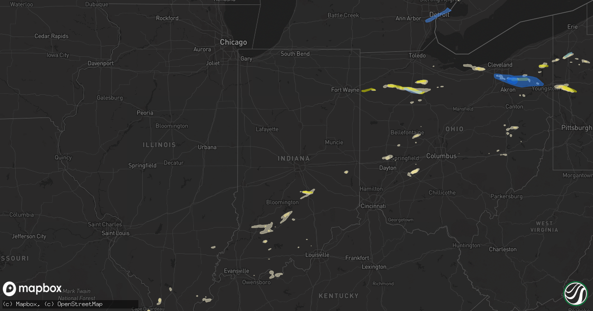
Hail Map in Indiana on June 1, 2022
Get this storm
June 1 map
$229
one time, instant access
Download today. No call, no setup
Keep the $229
Bought the map and want the full workflow? Apply the entire $229 to a subscription within 7 days. None of it is wasted.
Every map, not just this one
This buys you this map. Subscription and you get every map we run, in the markets you choose from a few cities to whole states to nationwide. Plus real-time alerts the moment a storm fires.
Contact data
Name, contact info, occupancy, even credit band for addresses in the footprint. You go from where it hit to who to call.
Become the source they trust
Unlimited branding weather history reports on demand. You already have the documented answer ready for the property owner, and you are the one who showed up with it.
Property data and RoofTrace estimates
Pull up any address you have got, its value and the exact code rules for that jurisdiction, straight from One Click Code. Then RoofTrace estimates the squares, pitch, and roof value, priced the way you price.
Storm reports in Indiana
Indiana
| Date | Description |
|---|---|
| 06/01/20226:49 PM CDT | Two trees snapped... Roof shingles blown off. Time estimated from radar data. |
| 06/01/20226:44 PM CDT | Two trees snapped... Roof shingles blown off. Time estimated from radar data. Corrected time of event. |
| 06/01/20226:25 PM CDT | Reports of trees down in roberts park |
| 06/01/20226:16 PM CDT | A few half dollar hail stones with many quarter size hail stones nw of the hwy-31... I-65 interchange. |
| 06/01/20226:15 PM CDT | Large tree branches down on u.s. 31. |
| 06/01/20225:25 PM CDT | Delayed report. |
| 06/01/20222:00 PM CDT | Poles down along west washington school road. |
| 06/01/20222:04 AM CDT | At 703 PM EDT, a severe thunderstorm was located 7 miles south of Franklin, or 13 miles northwest of Columbus, moving east at 30 mph. HAZARD...60 mph wind gusts and quarter size hail. SOURCE...Radar indicated. IMPACT...Hail damage to vehicles is expected. Expect wind damage to roofs, siding, and trees. This severe thunderstorm will be near... Flat Rock and Marietta around 720 PM EDT.Other locations in the path of this severe thunderstorm includeShelbyville.This includes the following highways... Interstate 65 between mile markers 77 and 90. Interstate 74 between mile markers 109 and 110. |
| 06/01/20221:31 AM CDT | At 631 PM EDT, a severe thunderstorm was located near Washington, or 19 miles north of Petersburg, moving northeast at 15 mph. HAZARD...60 mph wind gusts and quarter size hail. SOURCE...Radar indicated. IMPACT...Hail damage to vehicles is expected. Expect wind damage to roofs, siding, and trees. This severe thunderstorm will be near... Plainville around 635 PM EDT.Other locations in the path of this severe thunderstorm includeElnora, Odon and West Boggs Lake. |
| 06/01/20221:22 AM CDT | At 622 PM EDT, a severe thunderstorm was located near Bedford, moving northeast at 25 mph. HAZARD...60 mph wind gusts and quarter size hail. SOURCE...Radar indicated. IMPACT...Hail damage to vehicles is expected. Expect wind damage to roofs, siding, and trees. This severe thunderstorm will be near... Monroe Reservoir around 635 PM EDT. Charles Deam Wilderness around 640 PM EDT. |
| 06/01/20221:18 AM CDT | At 618 PM EDT, a severe thunderstorm was located 10 miles northeast of Columbus, moving northeast at 30 mph. HAZARD...60 mph wind gusts and quarter size hail. SOURCE...Radar indicated. IMPACT...Hail damage to vehicles is expected. Expect wind damage to roofs, siding, and trees. This severe thunderstorm will be near... Geneva around 630 PM EDT. Burney around 635 PM EDT.Other locations in the path of this severe thunderstorm includeMilford, Waldron and St. Paul.This includes Interstate 74 between mile markers 116 and 123. |
| 06/01/202212:19 AM CDT | At 519 PM EDT, a severe thunderstorm was located 7 miles northeast of Jasper, or 21 miles east of Petersburg, moving east at 20 mph. HAZARD...60 mph wind gusts and quarter size hail. SOURCE...Radar indicated. IMPACT...Hail damage to vehicles is expected. Expect wind damage to roofs, siding, and trees. This severe thunderstorm will remain over mainly rural areas of southern Martin and southeastern Daviess Counties. |
| 06/01/202212:14 AM CDT | At 513 PM EDT, a severe thunderstorm was located 10 miles northeast of Jasper, moving east at 30 mph. HAZARD...70 mph wind gusts and quarter size hail. SOURCE...Radar indicated. IMPACT...Hail damage to vehicles is expected. Expect considerable tree damage. Wind damage is also likely to mobile homes, roofs, and outbuildings. This severe thunderstorm will remain over mainly rural areas of northern Dubois and southwestern Orange Counties, including the following locations... Dubois, Hillham, Portersville, Dubois Crossroads, Norton, French Lick, Kellerville, Haysville, Ellsworth and Greenbrier. |
All States Impacted by Hail Map on June 1, 2022
Cities Impacted by Hail Map on June 1, 2022
- Factoryville, PA
- Fleetville, PA
- Nicholson, PA
- Jamestown, OH
- Harsens Island, MI
- Marysville, OH
- Raymond, OH
- Zanesfield, OH
- East Liberty, OH
- West Liberty, OH
- Blairstown, NJ
- Great Meadows, NJ
- Stanton, TN
- Algonac, MI
- Limaville, OH
- Alliance, OH
- Atwater, OH
- Bells, TN
- London, OH
- Marion, AR
- Vermilion, OH
- Sheffield Lake, OH
- North Ridgeville, OH
- Avon, OH
- Amherst, OH
- Lorain, OH
- Elyria, OH
- Blytheville, AR
- Pataskala, OH
- Sayre, OK
- Eddyville, KY
- Fredonia, KY
- Dubois, IN
- Loogootee, IN
- Jasper, IN
- Weatherford, OK
- Paulding, OH
- Haviland, OH
- Morganfield, KY
- Sturgis, KY
- Cabot, AR
- Austin, AR
- Somerville, TN
- Williston, TN
- Allegany, NY
- Alamo, TN
- Halls, TN
- Friendship, TN
- Oil City, PA
- Cooperstown, PA
- Titusville, PA
- Letona, AR
- Searcy, AR
- Tiffin, OH
- Harrison, AR
- Mount Blanchard, OH
- Carey, OH
- Wharton, OH
- Great Bend, PA
- Hallstead, PA
- Susquehanna, PA
- Dyersburg, TN
- Oak Harbor, OH
- Aubrey, TX
- Little Elm, TX
- Wheeler, TX
- Ellery, IL
- Albion, IL
- Walnut Ridge, AR
- Cash, AR
- Leedey, OK
- Endicott, NY
- Conklin, NY
- Newark Valley, NY
- Vestal, NY
- Johnson City, NY
- Brackney, PA
- Maine, NY
- Binghamton, NY
- Owego, NY
- Omaha, AR
- Byesville, OH
- New Concord, OH
- Cambridge, OH
- Herod, IL
- Judsonia, AR
- Foster, OK
- Elmore City, OK
- Stamford, TX
- Ethel, AR
- De Witt, AR
- Saint Charles, AR
- Altus, AR
- Clarksville, AR
- Hartman, AR
- Harpursville, NY
- Windsor, NY
- Bald Knob, AR
- Cochranton, PA
- Pampa, TX
- Saint Meinrad, IN
- Mitchell, IN
- Sugarcreek, OH
- New Philadelphia, OH
- Mclean, TX
- Shamrock, TX
- Mobeetie, TX
- Arlington, TN
- Watonga, OK
- Panhandle, TX
- Lynn, AR
- Smithville, AR
- Bristolville, OH
- Cortland, OH
- Marion, KY
- Shippenville, PA
- Lone Wolf, OK
- Granite, OK
- Willow, OK
- Carter, OK
- Anna, IL
- Jonesboro, IL
- Cobden, IL
- Slippery Rock, PA
- Mercer, PA
- Pulaski, PA
- West Middlesex, PA
- Grove City, PA
- Volant, PA
- New Castle, PA
- New Wilmington, PA
- Republic, OH
- Elizabethtown, IL
- Kenton, TN
- Mount Sidney, VA
- Fort Defiance, VA
- Salem, KY
- Farmdale, OH
- Orwell, OH
- North Bloomfield, OH
- Williamsfield, OH
- Kinsman, OH
- Kingston, AR
- Paris, AR
- Connersville, IN
- Bedford, VA
- Taloga, OK
- Putnam, OK
- Medway, OH
- Lockesburg, AR
- Nashville, AR
- Warren, OH
- Forest, OH
- Arlington, OH
- Fostoria, OH
- Kansas, OH
- Bloomdale, OH
- Risingsun, OH
- Floyds Knobs, IN
- Borden, IN
- Norman, IN
- Bedford, IN
- Port Washington, OH
- Newcomerstown, OH
- Gnadenhutten, OH
- Marked Tree, AR
- Marion, IL
- Carbondale, IL
- Lueders, TX
- Hodgen, OK
- West Mansfield, OH
- Richwood, OH
- Clarendon, TX
- Avoca, IN
- Williams, IN
- Heltonville, IN
- Oolitic, IN
- Finley, TN
- Thompson, PA
- Jackson, PA
- Arapaho, OK
- Butler, OK
- Clinton, OK
- North Lewisburg, OH
- Woodstock, OH
- Utica, PA
- Laceyville, PA
- Lawton, PA
- Montrose, PA
- Guys Mills, PA
- New Bethlehem, PA
- Templeton, PA
- Rimersburg, PA
- Scott City, MO
- Cape Girardeau, MO
- McClure, IL
- Uhrichsville, OH
- Midvale, OH
- Dennison, OH
- Nineveh, IN
- Trafalgar, IN
- Jamestown, PA
- Andover, OH
- Linesville, PA
- Hartstown, PA
- Zanesville, OH
- Hardinsburg, KY
- Rome, IN
- Hawesville, KY
- Cannelton, IN
- Union Dale, PA
- Chenango Forks, NY
- Castle Creek, NY
- Springville, PA
- Meshoppen, PA
- Scranton, PA
- Waverly, PA
- Moscow, PA
- Tunkhannock, PA
- Dalton, PA
- Clarks Summit, PA
- Olyphant, PA
- Swifton, AR
- Danville, AR
- Waldron, AR
- Haskell, TX
- Biscoe, AR
- Des Arc, AR
- Seminole, TX
- Friona, TX
- Floydada, TX
- Matador, TX
- Throckmorton, TX
- Newcastle, TX
- Stuttgart, AR
- Almyra, AR
- Carbon, TX
- Rising Star, TX
- Stanton, TX
- Argyle, TX
- Fort Lauderdale, FL
- Clarendon, AR
- Holly Grove, AR
- Dresden, TN
- Palmersville, TN
- Dukedom, TN
- Lake Dallas, TX
- Mentone, TX
- Seymour, TX
- Heth, AR
- Naples, FL
- Bonita Springs, FL
- Canyon, TX
- Happy, TX
- Claude, TX
- Santa Anna, TX
- Carnegie, OK
- Cordell, OK
- Alvada, OH
- Arcadia, OH
- McComb, OH
- Findlay, OH
- Quitaque, TX
- Turkey, TX
- Ballinger, TX
- Rowena, TX
- Miles, TX
- Quail, TX
- Wellington, TX
- Valentine, TX
- Fort Davis, TX
- Pecos, TX
- Balmorhea, TX
- Paint Rock, TX
- Lockney, TX
- Kress, TX
- Silverton, TX
- Tulia, TX
- Andrews, TX
- Goldsmith, TX
- Hobbs, NM
- Lovington, NM
- Comanche, TX
- Brownsville, TN
- Garden City, TX
- Corn, OK
- Colony, OK
- Hydro, OK
- Snyder, TX
- Hermleigh, TX
- Decatur, TX
- Mullin, TX
- Leipsic, OH
- Bangs, TX
- Hollis, OK
- Midland, TX
- South Solon, OH
- Jeffersonville, OH
- Marlow, OK
- Duncan, OK
- Mellwood, AR
- Ozark, AR
- Brecksville, OH
- North Royalton, OH
- Broadview Heights, OH
- Peninsula, OH
- Hinckley, OH
- Richfield, OH
- Jal, NM
- Electra, TX
- Holliday, TX
- Tyronza, AR
- Meadville, PA
- Conneaut Lake, PA
- West Helena, AR
- Helena, AR
- Justin, TX
- Rhome, TX
- Pilot Point, TX
- Eden, TX
- Millersview, TX
- Menard, TX
- Olney, TX
- Woodson, TX
- Albany, TX
- Breckenridge, TX
- Brownwood, TX
- Del Rio, TX
- Moran, TX
- Bono, AR
- The Colony, TX
- Flomot, TX
- Abilene, TX
- Baird, TX
- Vandalia, OH
- Tipp City, OH
- Crowell, TX
- Haughton, LA
- Princeton, LA
- Maljamar, NM
- Marathon, TX
- Dodson, TX
- Englewood, OH
- West Milton, OH
- Alpine, TX
- Continental, OH
- New Riegel, OH
- New Bavaria, OH
- Mason, TN
- Pep, NM
- Roswell, NM
- Elida, NM
- Freeport, OH
- Durant, OK
- Washington, IN
- Odon, IN
- Cannelburg, IN
- Crane, IN
- Shoals, IN
- Plainville, IN
- Montgomery, IN
- Avoca, TX
- Dimmitt, TX
- Hereford, TX
- Irving, TX
- Flower Mound, TX
- Lewisville, TX
- Coppell, TX
- Grapevine, TX
- Southlake, TX
- Frisco, TX
- Arthur City, TX
- Sumner, TX
- Telephone, TX
- Miami, FL
- Eola, TX
- Kermit, TX
- Gunnison, MS
- Centerville, TX
- Edinburgh, IN
- Columbus, IN
- Hartville, OH
- Canton, OK
- Oakwood, OK
- Wynnewood, OK
- Newbern, TN
- Cisco, TX
- Voss, TX
- Brookland, AR
- Jonesboro, AR
- Tutwiler, MS
- Gouldbusk, TX
- Saint Paris, OH
- Pekin, IN
- Drasco, AR
- Whitney Point, NY
- Berkshire, NY
- Lisle, NY
- Glen Aubrey, NY
- Ravenna, OH
- Newton Falls, OH
- Garrettsville, OH
- Windham, OH
- Green Forest, AR
- Davis, OK
- Crawfordsville, AR
- Plano, TX
- Roanoke, TX
- Tunica, MS
- Marianna, AR
- Smithville, OK
- Heavener, OK
- Steele, MO
- Strong, AR
- Huttig, AR
- Tyler, TX
- Arp, TX
- Vancourt, TX
- Briscoe, TX
- Memphis, TX
- Mangum, OK
- Early, TX
- Deport, TX
- Winters, TX
- Rochelle, TX
- Odessa, TX
- Rockwood, TX
- Bell City, MO
- Oran, MO
- Benton, MO
- Cave In Rock, IL
- Mead, OK
- Caddo, OK
- Calera, OK
- Saint Anthony, IN
- Huntingburg, IN
- Schnellville, IN
- Malvern, PA
- Wayne, PA
- Phoenixville, PA
- Gilmore, AR
- Turrell, AR
- Bluffton, AR
- Gravelly, AR
- Tatum, NM
- Canadian, TX
- Mantua, OH
- Northfield, OH
- Hudson, OH
- Streetsboro, OH
- Coleman, TX
- Lepanto, AR
- Ripley, TN
- Flat Rock, IN
- Taylorsville, IN
- Hope, IN
- Nashville, IN
- Thomas, OK
- Joiner, AR
- Wilson, AR
- Hiram, OH
- Depauw, IN
- Rockport, IN
- Booneville, AR
- Aledo, TX
- Magazine, AR
- Mayflower, AR
- Conway, AR
- Bigelow, AR
- Gardendale, TX
- West Monroe, LA
- Martin, TN
- South Fulton, TN
- Brookesmith, TX
- Lewisport, KY
- Tell City, IN
- Summerville, SC
- Gorman, TX
- Ponder, TX
- Payne, OH
- Charleston, MO
- Miller City, IL
- Barlow, KY
- Villa Ridge, IL
- Mound City, IL
- Mounds, IL
- Olmsted, IL
- Cairo, IL
- Thebes, IL
- Loving, NM
- Milan, PA
- Ulster, PA
- East Smithfield, PA
- Athens, PA
- Rome, PA
- Van Horn, TX
- Wink, TX
- Ranger, TX
- Eastland, TX
- Latty, OH
- Saegertown, PA
- Diamond, OH
- Niles, OH
- Strongsville, OH
- Brunswick, OH
- Twinsburg, OH
- Stow, OH
- Mineral Ridge, OH
- Leavittsburg, OH
- Aurora, OH
- Kent, OH
- McDonald, OH
- Southington, OH
- Macedonia, OH
- Cuyahoga Falls, OH
- Grosse Pointe, MI
- Taylor, MI
- Dearborn, MI
- Allen Park, MI
- Southgate, MI
- Romulus, MI
- Dearborn Heights, MI
- Ecorse, MI
- Lincoln Park, MI
- River Rouge, MI
- Detroit, MI
- Melvindale, MI


