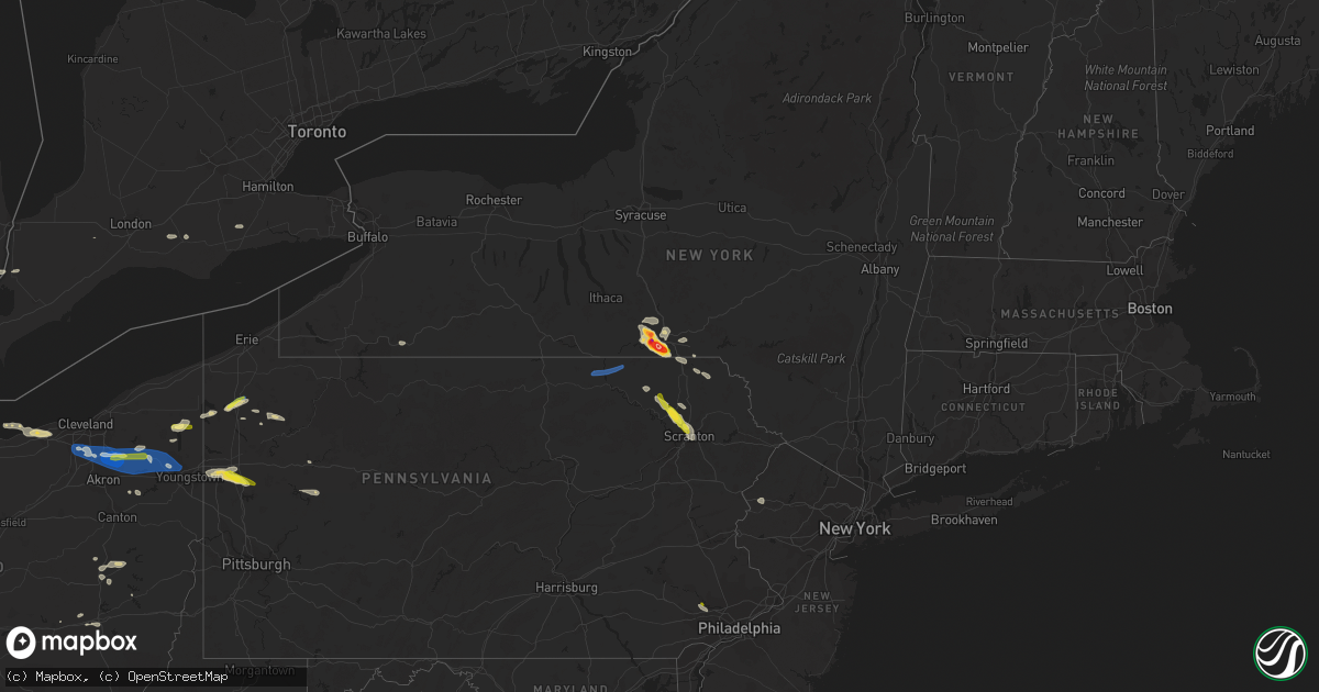
Hail Map on June 1, 2022
Get this storm
June 1 map
$229
one time, instant access
Download today. No call, no setup
Keep the $229
Bought the map and want the full workflow? Apply the entire $229 to a subscription within 7 days. None of it is wasted.
Every map, not just this one
This buys you this map. Subscription and you get every map we run, in the markets you choose from a few cities to whole states to nationwide. Plus real-time alerts the moment a storm fires.
Contact data
Name, contact info, occupancy, even credit band for addresses in the footprint. You go from where it hit to who to call.
Become the source they trust
Unlimited branding weather history reports on demand. You already have the documented answer ready for the property owner, and you are the one who showed up with it.
Property data and RoofTrace estimates
Pull up any address you have got, its value and the exact code rules for that jurisdiction, straight from One Click Code. Then RoofTrace estimates the squares, pitch, and roof value, priced the way you price.
States Impacted by Hail Map on June 1, 2022
Storm reports
Oklahoma
| Date | Description |
|---|---|
| 06/01/20227:49 AM CDT | At 1249 AM CDT, severe thunderstorms were located along a line extending from 3 miles west of Gracemont to near Chickasha to near Marlow, moving northeast at 35 mph. HAZARD...70 mph wind gusts and quarter size hail. SOURCE...Radar indicated. IMPACT...Hail damage to vehicles is expected. Expect considerable tree damage. Wind damage is also likely to mobile homes, roofs, and outbuildings. Locations impacted include... Southwestern Oklahoma City, El Reno, Chickasha, Newcastle, Blanchard, Mustang, Tuttle, Lindsay, Union City, Minco, Rush Springs, Dibble, Washington, Cole, Alex, Verden, Amber, Bridge Creek, Gracemont and Pocasset. |
| 06/01/20227:15 AM CDT | At 1214 AM CDT, severe thunderstorms were located along a line extending from 3 miles southwest of Boone to 7 miles south of Elgin to near Geronimo, moving northeast at 50 mph. HAZARD...70 mph wind gusts and quarter size hail. SOURCE...Trained weather spotters measured a 70 mph wind gust east of Medicine Park. IMPACT...Hail damage to vehicles is expected. Expect considerable tree damage. Wind damage is also likely to mobile homes, roofs, and outbuildings. Locations impacted include... Eastern Lawton, Chickasha, Anadarko, Marlow, Elgin, Apache, Rush Springs, Bray, Fletcher, Cyril, Sterling, Fort Cobb, Alex, Verden, Cement, Medicine Park, Gracemont, Norge, Bradley and Boone. |
| 06/01/20225:10 AM CDT | At 1010 PM CDT, a severe thunderstorm was located 5 miles southeast of Quail, or 7 miles west of Wellington, moving northeast at 50 mph. HAZARD...Half dollar size hail. SOURCE...Radar indicated. IMPACT...Damage to vehicles is expected. Locations impacted include... Wellington, Quail and Lutie. |
| 06/01/20224:54 AM CDT | At 953 PM CDT, a severe thunderstorm was located 6 miles west of Lela, or 12 miles west of Shamrock, moving east at 30 mph. HAZARD...Quarter size hail. SOURCE...Radar indicated. IMPACT...Damage to vehicles is expected. Locations impacted include... Shamrock, Lutie, Twitty, Dozier, Lela, Samnorwood and Kellerville. |
| 06/01/20221:34 AM CDT | At 634 AM CDT, a severe thunderstorm was located 8 miles west of New Mobeetie, or 9 miles south of Miami, moving east at 30 mph. HAZARD...Quarter size hail. SOURCE...Radar indicated. IMPACT...Damage to vehicles is expected. Locations impacted include... Briscoe, Wheeler, Allison, New Mobeetie, Codman and Mobeetie. |
| 05/31/202211:44 PM CDT | At 444 PM CDT, a severe thunderstorm was located near Putnam, moving northeast at 25 mph. HAZARD...60 mph wind gusts and half dollar size hail. SOURCE...Radar indicated. IMPACT...Hail damage to vehicles is expected. Expect wind damage to roofs, siding, and trees. Locations impacted include... Oakwood and Hucmac. |
| 05/31/202210:28 PM CDT | At 327 PM CDT, a severe thunderstorm was located 6 miles northwest of Mangum, moving northeast at 20 mph. HAZARD...60 mph wind gusts and quarter size hail. SOURCE...Radar indicated. IMPACT...Hail damage to vehicles is expected. Expect wind damage to roofs, siding, and trees. Locations impacted include... Mangum, Granite, Willow, Brinkman and Altus-Lugert Lake. |
| 05/31/20229:20 PM CDT | At 220 AM CDT, severe thunderstorms were located along a line extending from near Elmer to near Odell to 3 miles south of Medicine Mound, moving east at 45 mph. HAZARD...60 mph wind gusts and half dollar size hail. SOURCE...Radar indicated. IMPACT...Hail damage to vehicles is expected. Expect wind damage to roofs, siding, and trees. Locations impacted include... Vernon, Frederick, Tipton, Chillicothe, Davidson, Manitou, Elmer, Fargo, Odell and Hess. |
| 05/31/20229:16 PM CDT | At 216 AM CDT, severe thunderstorms were located along a line extending from 3 miles north of Warwick to near Sparks to near Johnson, moving northeast at 55 mph. HAZARD...60 mph wind gusts. SOURCE...Radar indicated. IMPACT...Expect damage to roofs, siding, and trees. Locations impacted include... Shawnee, Chandler, Stroud, Prague, Meeker, Davenport, Wellston, Carney, Johnson, Sparks, Warwick, Kendrick, Avery, Parkland, Aydelotte and Centerview. |
| 05/31/20228:53 PM CDT | At 153 AM CDT, severe thunderstorms were located along a line extending from 6 miles northeast of Goodlett to 6 miles southwest of Quanah to 11 miles northwest of Crowell, moving east at 35 mph. HAZARD...60 mph wind gusts and quarter size hail. SOURCE...Radar indicated. IMPACT...Hail damage to vehicles is expected. Expect wind damage to roofs, siding, and trees. Locations impacted include... Quanah, Chillicothe, Eldorado, Medicine Mound, Odell, Goodlett, Rayland and Copper Breaks State Park. |
| 05/31/20228:40 PM CDT | At 139 AM CDT, severe thunderstorms were located along a line extending from near Oklahoma City to near Stanley Draper Lake to near Norman, moving northeast at 45 mph. HAZARD...70 mph wind gusts and nickel size hail. SOURCE...Radar indicated. IMPACT...Expect considerable tree damage. Damage is likely to mobile homes, roofs, and outbuildings. Locations impacted include... Oklahoma City, Norman, southeastern Edmond, Moore, Midwest City, Shawnee, Del City, Tecumseh, Choctaw, Noble, Harrah, McLoud, Spencer, Jones, Nicoma Park, Pink, Luther, Meeker, Wellston and Valley Brook. |
| 05/31/20228:33 PM CDT | At 132 AM CDT, a severe thunderstorm was located 7 miles northwest of Chillicothe, moving east at 30 mph. HAZARD...60 mph wind gusts and half dollar size hail. SOURCE...Radar indicated. IMPACT...Hail damage to vehicles is expected. Expect wind damage to roofs, siding, and trees. Locations impacted include... Elmer, Odell and Hess. |
| 05/31/20228:10 PM CDT | At 110 AM CDT, severe thunderstorms were located along a line extending from near Pocasset to near Middleberg to 3 miles east of Alex, moving northeast at 45 mph. HAZARD...70 mph wind gusts and quarter size hail. SOURCE...Radar indicated. IMPACT...Hail damage to vehicles is expected. Expect considerable tree damage. Wind damage is also likely to mobile homes, roofs, and outbuildings. Locations impacted include... Oklahoma City, Norman, Moore, Midwest City, Del City, Newcastle, Blanchard, Purcell, Mustang, Choctaw, Noble, Tuttle, Slaughterville, Spencer, Goldsby, Dibble, Valley Brook, Washington, Cole and Alex. |
New York
| Date | Description |
|---|---|
| 06/01/20222:59 PM CDT | Photo of estimated golf ball size hail relayed via social media. Time estimated by radar. |
| 06/01/20222:55 PM CDT | Vestal near intersection of murray hill road and washington drive. Multiple trees down in yards. |
| 06/01/20222:55 PM CDT | Pea to quarter size hail south side of binghamton. |
| 06/01/20222:50 PM CDT | A local report indicates 1.75 inch wind near 2 SE ENDWELL |
| 06/01/20222:50 PM CDT | Photos of several trees uprooted and down. Sporadic damage. |
| 06/01/20222:50 PM CDT | A local report indicates 3.00 inch wind near VESTAL |
| 06/01/20222:50 PM CDT | Corrects previous hail report location from vestal. |
| 06/01/20222:50 PM CDT | A local report indicates 1.25 inch wind near VESTAL |
| 06/01/20222:49 PM CDT | Large tree down in backyard. |
| 06/01/20222:45 PM CDT | A local report indicates 1.00 inch wind near 3 SW BINGHAMTON |
| 06/01/20222:45 PM CDT | Tree down blocking roadway. |
| 06/01/20222:44 PM CDT | A local report indicates 2.00 inch wind near 1 W ENDWELL |
| 06/01/20222:43 PM CDT | At least golf ball size hail. |
| 06/01/20222:43 PM CDT | Report from mping: ping pong ball |
| 06/01/20222:42 PM CDT | A local report indicates 1.00 inch wind near 1 N ENDWELL |
| 06/01/20222:38 PM CDT | Corrects previous tstm wnd dmg report from endwell. Very large tree uprooted that fell on a car and a house on university avenue. |
| 06/01/20222:38 PM CDT | Tree down on a house on university avenue. |
| 06/01/20222:37 PM CDT | Tree down on a vehicle. |
| 06/01/20222:37 PM CDT | A local report indicates 1.00 inch wind near 1 NE WEST CORNERS |
| 06/01/20221:43 AM CDT | At 642 PM EDT, a severe thunderstorm was located over Milan, or near Athens, moving east at 40 mph. HAZARD...60 mph wind gusts and quarter size hail. SOURCE...Radar indicated. IMPACT...Hail damage to vehicles is expected. Expect wind damage to roofs, siding, and trees. Locations impacted include... Sayre, Athens, Sheshequin, Ulster, Litchfield, Orwell, Windham, Nichols, Rome and Le Raysville. |
| 05/31/20228:39 PM CDT | At 139 PM EDT, a severe thunderstorm was located over Thompson, or 15 miles south of Deposit, moving southeast at 25 mph. HAZARD...60 mph wind gusts and quarter size hail. SOURCE...Radar indicated. IMPACT...Hail damage to vehicles is expected. Expect wind damage to roofs, siding, and trees. Locations impacted include... Ararat, Lanesboro, Thompson, Union Dale, Starrucca, Hiawatha, Shehawken, Starlight, Starruca and Pleasant Mount. |
Missouri
| Date | Description |
|---|---|
| 06/01/20226:58 PM CDT | Trees down across highway 114 near miner... Extreme southern scott co near county line. |
| 06/01/20227:48 AM CDT | At 1247 AM CDT, a severe thunderstorm was located 8 miles northwest of Walnut, or 11 miles northeast of Erie, moving northeast at 25 mph. HAZARD...60 mph wind gusts and nickel size hail. SOURCE...Radar indicated. IMPACT...Expect damage to roofs, siding, and trees. Locations impacted include... Fort Scott... Marmaton... Bronson... Uniontown... Walnut... Fulton... Redfield... Hepler... Mapleton... Harding... Pawnee Station... Hiattville... Petersburg... Hammond... Devon... Garland... Porterville... |
| 06/01/20227:16 AM CDT | At 1215 AM CDT, a severe thunderstorm was located near Lone Elm, or 7 miles northeast of La Harpe, moving northeast at 30 mph. HAZARD...60 mph wind gusts and quarter size hail. SOURCE...Radar indicated. IMPACT...Hail damage to vehicles is expected. Expect wind damage to roofs, siding, and trees. Locations impacted include... Pleasanton, Mound City, Parker, Blue Mound and Prescott. |
| 06/01/20227:14 AM CDT | At 1214 AM CDT, a severe thunderstorm was located near Bronson, or 13 miles southeast of La Harpe, moving northeast at 65 mph. HAZARD...60 mph wind gusts and quarter size hail. SOURCE...Radar indicated. IMPACT...Hail damage to vehicles is expected. Expect wind damage to roofs, siding, and trees. Locations impacted include... Fort Scott... Marmaton... Bronson... Uniontown... Fulton... Redfield... Mapleton... Harding... Petersburg... Hammond... Devon... Porterville... Xenia... |
| 05/31/20228:44 PM CDT | At 144 AM CDT, a severe thunderstorm was located near Walnut, or 7 miles northwest of Girard, moving northeast at 25 mph. HAZARD...60 mph wind gusts. SOURCE...Radar indicated. IMPACT...Expect damage to roofs, siding, and trees. Locations impacted include... Frontenac... Girard... Arma... Mulberry... Franklin... Arcadia... Hepler... Burgess... Croweburg... Greenbush... Ringo... Pawnee Station... Hiattville... Farlington... Brazilton... Polk... Garland... Englevale... |
Pennsylvania
| Date | Description |
|---|---|
| 06/01/20226:40 PM CDT | Tree fell on chapel drive. |
| 06/01/20226:00 PM CDT | Power lines down near pulaski. Time estimated on radar. |
| 06/01/20226:00 PM CDT | Several trees and wires down. |
| 06/01/20225:50 PM CDT | Trees down in town |
| 06/01/20225:50 PM CDT | Corrects previous hail report from phoenixville. Social media. Time estimated via radar. |
| 06/01/20225:50 PM CDT | Trees down in franklin. Time estimated from radar. |
| 06/01/20225:50 PM CDT | Tree down blocking both lanes on front st. |
| 06/01/20225:48 PM CDT | Tree down on house. |
| 06/01/20225:45 PM CDT | Broadcast media reports viewers with quarter sized hail in meadville. Time estimated via radar. |
| 06/01/20225:40 PM CDT | Social media. Time estimated via radar. |
| 06/01/20225:39 PM CDT | Asos station kgkj meadville. |
| 06/01/20225:05 PM CDT | Tree and power lines downed in greenville. Time estimated from radar. |
| 06/01/20225:05 PM CDT | Tree and power lines blown down |
| 06/01/20224:50 PM CDT | Trees down in oakland. Time estimated from radar. |
| 06/01/20224:50 PM CDT | Trees down in oakland |
| 06/01/20224:40 PM CDT | Numerous trees snapped or uprooted along spring creek road and route 949 |
| 06/01/20224:40 PM CDT | Trees down in plum township. Time estimated from radar. |
| 06/01/20224:18 PM CDT | Numerous trees down. Roof damaged one house. |
| 06/01/20224:06 PM CDT | Multiple trees down on property. Tree parts scattered in yard and some buried in ground. Trees broke midway and up. Wind came hard and fast during thunderstorm. Time es |
| 06/01/20223:53 PM CDT | Trees down. |
| 06/01/20223:48 PM CDT | Trees down. |
| 06/01/20223:45 PM CDT | Tree down. |
| 06/01/20223:20 PM CDT | Tree on wires blocking one lane intersection of routes 3001 and 3004. |
| 06/01/20223:15 PM CDT | Trees and wires down in rush township. |
| 06/01/20224:04 AM CDT | At 904 PM EDT, a severe thunderstorm was located near Punxsutawney, moving east at 40 mph. HAZARD...60 mph wind gusts and quarter size hail. SOURCE...Radar indicated. IMPACT...Minor hail damage to vehicles is possible. Expect wind damage to trees and power lines, resulting in some power outages. Locations impacted include... Punxsutawney, Big Run, Rossiter, and Anita. |
| 06/01/20223:08 AM CDT | At 808 PM EDT, a severe thunderstorm was located near Rimersburg, moving east at 40 mph. HAZARD...60 mph wind gusts. SOURCE...Radar indicated. IMPACT...Expect damage to trees and power lines, resulting in some power outages. Locations impacted include... Clarion, Kittanning, Knox, Rimersburg, New Bethlehem, West Kittanning, East Brady, Rural Valley, Parker, Sligo, Worthington, and Dayton. |
| 06/01/20222:52 AM CDT | At 752 PM EDT, a severe thunderstorm was located near Apollo, moving east at 25 mph. HAZARD...60 mph wind gusts and quarter size hail. SOURCE...Radar indicated. IMPACT...Minor hail damage to vehicles is possible. Expect wind damage to trees and power lines, resulting in some power outages. Locations impacted include... Indiana, Homer City, Apollo, Black Lick, North Apollo, Avonmore, Orchard Hills, Saltsburg, Oklahoma, West Lebanon, Slickville, and Lucerne Mines. |
| 06/01/20222:39 AM CDT | At 739 PM EDT, a severe thunderstorm was located near Slippery Rock, or 7 miles southeast of Grove City, moving east at 40 mph. HAZARD...60 mph wind gusts and quarter size hail. SOURCE...Radar indicated. IMPACT...Minor hail damage to vehicles is possible. Expect wind damage to trees and power lines, resulting in some power outages. Locations impacted include... Grove City, Shanor-Northvue, Slippery Rock, Chicora, East Brady, Harrisville, Parker, Plain Grove Township, East Butler, Worthington, Emlenton, and Bruin. |
| 06/01/20222:07 AM CDT | At 706 PM EDT, a severe thunderstorm was located over Warren Center, or 11 miles south of Owego, moving east at 45 mph. HAZARD...60 mph wind gusts and penny size hail. SOURCE...Radar indicated. IMPACT...Expect damage to roofs, siding, and trees. Locations impacted include... Binghamton, Vestal, Johnson City, Endicott, Kirkwood, Conklin, Port Dickinson, Hallstead, Orwell and Windham. |
| 06/01/20221:52 AM CDT | At 652 PM EDT, a severe thunderstorm was located near Meadville, moving northeast at 35 mph. HAZARD...60 mph wind gusts and quarter size hail. SOURCE...Radar indicated. IMPACT...Minor damage to vehicles is possible. Expect damage to trees and power lines. Locations impacted include... Meadville, Union City, Cambridge Springs, Riceville, Lincolnville, Canadohta Lake, Guys Mills, Saegertown, Blooming Valley, Townville, Spartansburg, Venango, Elgin and Woodcock. |
| 06/01/20221:45 AM CDT | At 645 PM EDT, a severe thunderstorm was located over Valley Forge, or 11 miles northeast of West Chester, moving east at 10 mph. HAZARD...60 mph wind gusts and half dollar size hail. SOURCE...Radar indicated. IMPACT...Minor damage to vehicles is possible. Wind damage to roofs, siding, trees, and power lines is possible. Locations impacted include... Philadelphia, Norristown, Phoenixville, West Norriton, East Norriton, Yeadon, Conshohocken, Swarthmore, Royersford, Narberth, East Lansdowne, Morris Park, Bryn Mawr, Trout Lake, Radnor Township, Gradyville, Broomall, Newtown Square, Roxborough and King Of Prussia.This includes the following highways... Pennsylvania Turnpike between mile markers 319 and 336. Northeast Extension near mile marker 21. Interstate 76 in Pennsylvania between mile markers 327 and 339. Interstate 476 in Pennsylvania between mile markers 2 and 19. |
| 06/01/20221:09 AM CDT | At 608 PM EDT, a severe thunderstorm was located near Titusville, or 7 miles northeast of Oil City, moving southeast at 25 mph. HAZARD...60 mph wind gusts and quarter size hail. SOURCE...Radar indicated. IMPACT...Minor hail damage to vehicles is possible. Expect wind damage to trees and power lines, resulting in some power outages. Locations impacted include... Oil City, Tionesta, Hasson Heights, Rouseville, Fryburg, and Oil Creek State Park. |
| 06/01/202212:52 AM CDT | At 551 PM EDT, a severe thunderstorm was located over Angels, or 10 miles north of Mount Pocono, moving southeast at 35 mph. HAZARD...60 mph wind gusts and penny size hail. SOURCE...Radar indicated. IMPACT...Expect damage to roofs, siding, and trees. Locations impacted include... Sterling, Lehigh, Greentown, Gouldsboro, Angels, Panther, Daleville, Fells Corners, Newfoundland and La Anna. |
| 06/01/202212:48 AM CDT | At 548 PM EDT, a severe thunderstorm was located 7 miles southeast of Guys Mills, or 12 miles northwest of Oil City, moving east at 15 mph. HAZARD...60 mph wind gusts and quarter size hail. SOURCE...Radar indicated. IMPACT...Minor hail damage to vehicles is possible. Expect wind damage to trees and power lines, resulting in some power outages. Locations impacted include... Oil City, Sugarcreek, Hasson Heights, Seneca, Rouseville, Cooperstown, Woodland Heights, Pleasantville, and Oil Creek State Park. |
| 06/01/202212:28 AM CDT | At 527 PM EDT, a severe thunderstorm was located over Elmhurst, or 7 miles east of Scranton, moving southeast at 35 mph. HAZARD...70 mph wind gusts and ping pong ball size hail. SOURCE...Radar indicated. IMPACT...People and animals outdoors will be injured. Expect hail damage to roofs, siding, windows, and vehicles. Expect considerable tree damage. Wind damage is also likely to mobile homes, roofs, and outbuildings. Locations impacted include... Mount Pocono, Tobyhanna, Reeders, Henryville, Pocono Pines, Analomink, Skytop, Tannersville, Mountainhome, Canadensis, Alpine Mountain, Scotrun, Paradise Valley, Gouldsboro State Park, Cresco and Bartonsville.This includes the following highways... Interstate 80 in Pennsylvania between mile markers 296 and 306. Interstate 380 in Pennsylvania between mile markers 0 and 12. |
| 06/01/202212:24 AM CDT | At 523 PM EDT, a severe thunderstorm was located over Dunmore, or near Scranton, moving southeast at 25 mph. HAZARD...70 mph wind gusts and quarter size hail. SOURCE...Radar indicated. IMPACT...Hail damage to vehicles is expected. Expect considerable tree damage. Wind damage is also likely to mobile homes, roofs, and outbuildings. Locations impacted include... Scranton, Dunmore, Old Forge, Pittston, Archbald, Blakely, Taylor, Dickson City, Moosic and Exeter. |
| 06/01/202212:10 AM CDT | At 510 PM EDT, a severe thunderstorm was located near Kinsman, or 17 miles north of Warren, moving east at 35 mph. HAZARD...60 mph wind gusts and quarter size hail. SOURCE...Radar indicated. IMPACT...Minor damage to vehicles is possible. Expect damage to trees and power lines. Locations impacted include... Kinsman, Orwell, Adamsville, Atlantic, Pymatuning Central, Jamestown and Hartstown. |
| 06/01/202212:04 AM CDT | At 504 PM EDT, a severe thunderstorm was located over Clarks Green, or over Waverly, moving southeast at 30 mph. HAZARD...Two inch hail and 70 mph wind gusts. SOURCE...Radar indicated. IMPACT...People and animals outdoors will be injured. Expect hail damage to roofs, siding, windows, and vehicles. Expect considerable tree damage. Wind damage is also likely to mobile homes, roofs, and outbuildings. Locations impacted include... Scranton, Dunmore, Carbondale, Archbald, Blakely, Taylor, Dickson City, Moosic, Olyphant and Clarks Summit. |
| 05/31/202211:38 PM CDT | At 438 PM EDT, a severe thunderstorm was located near Lake Carey, or near Tunkhannock, moving southeast at 30 mph. HAZARD...Two inch hail and 70 mph wind gusts. SOURCE...Radar indicated. IMPACT...People and animals outdoors will be injured. Expect hail damage to roofs, siding, windows, and vehicles. Expect considerable tree damage. Wind damage is also likely to mobile homes, roofs, and outbuildings. Locations impacted include... Clarks Summit, Rush, Clifford, Tunkhannock, Springville, Dimock, Clarks Green, Glenburn, Dalton and Factoryville. |
| 05/31/202211:15 PM CDT | At 414 PM EDT, a severe thunderstorm was located over Rush, or 10 miles southwest of Montrose, moving southeast at 30 mph. HAZARD...70 mph wind gusts and quarter size hail. SOURCE...Radar indicated. IMPACT...Hail damage to vehicles is expected. Expect considerable tree damage. Wind damage is also likely to mobile homes, roofs, and outbuildings. Locations impacted include... Rush, Springville, Dimock, Nicholson, Hop Bottom, Lake Carey, Rushville, Auburn Center, Elk Lake and Stevensville. |
| 05/31/202211:10 PM CDT | At 409 PM EDT, a severe thunderstorm was located over Brackney, or 8 miles south of Binghamton, moving southeast at 30 mph. HAZARD...60 mph wind gusts and quarter size hail. SOURCE...Radar indicated. IMPACT...Hail damage to vehicles is expected. Expect wind damage to roofs, siding, and trees. Locations impacted include... Montrose, Hallstead, New Milford, Great Bend, Lakeview, Salt Springs State Park, Lakeside and Wyoanna. |
| 05/31/202210:33 PM CDT | At 333 PM EDT, a severe thunderstorm was located over Union Center, or over Endicott, moving southeast at 20 mph. HAZARD...60 mph wind gusts and penny size hail. SOURCE...Radar indicated. IMPACT...Expect damage to roofs, siding, and trees. Locations impacted include... Binghamton, Vestal, Johnson City, Endicott, Little Meadows, Vestal Center, Endwell, Tioga Terrace, Brackney and West Corners. |
| 05/31/20228:05 PM CDT | Report from mping: 1-inch tree limbs broken; shingles blown off. |
| 05/31/20227:41 PM CDT | Tree down on wires. Time estimated via radar. |
| 05/31/20227:41 PM CDT | Corrected the source. Tree down on wires. Time estimated via radar. |
| 05/31/20227:20 PM CDT | Trees were reported down near widnoon |
| 05/31/20227:12 PM CDT | Multiple trees down. Time estimate from radar. |
| 05/31/20227:08 PM CDT | Social media report and photos of multiple trees down in east brady. |
Texas
| Date | Description |
|---|---|
| 06/01/20226:55 PM CDT | A local report indicates 1.75 inch wind near GOLDSMITH |
| 06/01/20226:38 PM CDT | Accumulated hail piles several inches deep covering road. Largest stones up to golf ball size. |
| 06/01/20226:18 PM CDT | Recorded by vehicle mounted anemometer. |
| 06/01/20225:35 PM CDT | A local report indicates 1.25 inch wind near 2 E ALPINE |
| 06/01/20225:33 PM CDT | Report from mping: hen egg |
| 06/01/20227:43 AM CDT | At 1242 AM CDT, severe thunderstorms were located along a line extending from 5 miles northeast of Matador to 7 miles northwest of Petersburg, moving east at 25 mph. THESE ARE DESTRUCTIVE STORMS FOR FLOYDADA, DOUGHERTY, AND PADUCAH. HAZARD...Three inch hail and 60 mph wind gusts. SOURCE...Radar indicated. IMPACT...People and animals outdoors will be severely injured. Expect shattered windows, extensive damage to roofs, siding, and vehicles. Locations impacted include... Floydada, Paducah, Matador, Lockney, Cee Vee, Dougherty, Aiken, Swearingen and Roaring Springs. |
| 06/01/20226:34 AM CDT | At 1134 PM CDT, a severe thunderstorm was located 8 miles northeast of Turkey, moving northeast at 20 mph. HAZARD...60 mph wind gusts and quarter size hail. SOURCE...Radar indicated. IMPACT...Hail damage to vehicles is expected. Expect wind damage to roofs, siding, and trees. Locations impacted include... Plaska Community. |
| 06/01/20226:30 AM CDT | At 1129 PM CDT, a severe thunderstorm was located near Claytonville, or 12 miles southwest of Silverton, moving southeast at 20 mph. HAZARD...60 mph wind gusts and quarter size hail. SOURCE...Radar indicated. IMPACT...Hail damage to vehicles is expected. Expect wind damage to roofs, siding, and trees. Locations impacted include... Silverton, Caprock Canyon State Park and Claytonville. |
| 06/01/20226:29 AM CDT | At 1129 PM CDT, a severe thunderstorm was located 5 miles east of Matador, moving southeast at 5 mph. HAZARD...Ping pong ball size hail and 60 mph wind gusts. SOURCE...Radar indicated. IMPACT...People and animals outdoors will be injured. Expect hail damage to roofs, siding, windows, and vehicles. Expect wind damage to roofs, siding, and trees. This severe thunderstorm will remain over mainly rural areas of northern Dickens, southeastern Motley and west central Cottle Counties. |
| 06/01/20226:27 AM CDT | At 1127 PM CDT, a severe thunderstorm was located over Fort Griffin, moving south at 25 mph. HAZARD...60 mph wind gusts and quarter size hail. SOURCE...Radar indicated. IMPACT...Hail damage to vehicles is expected. Expect wind damage to roofs, siding, and trees. This severe thunderstorm will be near... Albany around 1200 AM CDT. Ibex around 1210 AM CDT.Other locations impacted by this severe thunderstorm include Us-180 Near The Shackelford-Stephens County Line and The Intersection Of Us-283 And Ranch Road 209. |
| 06/01/20226:15 AM CDT | At 1114 PM CDT, a severe thunderstorm was located near Woodson, moving southeast at 30 mph. HAZARD...60 mph wind gusts and half dollar size hail. SOURCE...Radar indicated. IMPACT...Hail damage to vehicles is expected. Expect wind damage to roofs, siding, and trees. This severe thunderstorm will be near... Woodson around 1120 PM CDT.Other locations impacted by this severe thunderstorm include Lusk,The Intersection Of Us-183 And Us-283 and The Intersection Of Us-283 And Ranch Road 209. |
| 06/01/20225:58 AM CDT | At 1058 PM CDT, a severe thunderstorm was located 5 miles south of Turkey, moving southeast at 15 mph. HAZARD...Golf ball size hail and 60 mph wind gusts. SOURCE...Radar indicated. IMPACT...People and animals outdoors will be injured. Expect hail damage to roofs, siding, windows, and vehicles. Expect wind damage to roofs, siding, and trees. Locations impacted include... Turkey and Northfield. |
| 06/01/20225:29 AM CDT | At 1029 PM CDT, a severe thunderstorm was located over Matador, moving southeast at 10 mph. HAZARD...60 mph wind gusts and quarter size hail. SOURCE...Radar indicated. IMPACT...Hail damage to vehicles is expected. Expect wind damage to roofs, siding, and trees. Locations impacted include... Matador, Afton and Roaring Springs. |
| 06/01/20225:27 AM CDT | At 1027 PM CDT, a severe thunderstorm was located 7 miles east of Tulia, moving southeast at 25 mph. HAZARD...60 mph wind gusts and quarter size hail. SOURCE...Radar indicated. IMPACT...Hail damage to vehicles is expected. Expect wind damage to roofs, siding, and trees. Locations impacted include... Tulia, Silverton, Vigo Park, Mackenzie Reservoir and Claytonville. |
| 06/01/20225:24 AM CDT | At 1023 PM CDT, a severe thunderstorm was located 10 miles northwest of Elbert, moving south at 10 mph. HAZARD...Golf ball size hail. SOURCE...Radar indicated. IMPACT...People and animals outdoors will be injured. Expect damage to roofs, siding, windows, and vehicles. This severe thunderstorm will be near... Elbert around 1105 PM CDT. |
| 06/01/20225:06 AM CDT | At 1006 PM CDT, a severe thunderstorm was located over Valley Schools, or 4 miles southeast of Caprock Canyon State Park, and is nearly stationary. HAZARD...60 mph wind gusts and quarter size hail. SOURCE...Radar indicated. IMPACT...Hail damage to vehicles is expected. Expect wind damage to roofs, siding, and trees. Locations impacted include... Turkey, Caprock Canyon State Park and Valley Schools. |
| 06/01/20225:05 AM CDT | At 1004 PM CDT, a severe thunderstorm was located 7 miles southwest of Millers Creek Reservoir, moving east at 15 mph. HAZARD...Half dollar size hail. SOURCE...Radar indicated. IMPACT...Damage to vehicles is expected. This severe thunderstorm will remain over mainly rural areas of northern Throckmorton County, including the following locations... Us-183 Near The Throckmorton-Baylor County Line and The Intersection Of Us-380 And Highway 222. |
| 06/01/20225:03 AM CDT | At 1003 PM CDT, a severe thunderstorm was located near Westover, moving southeast at 10 mph. HAZARD...Two inch hail and 60 mph wind gusts. SOURCE...Radar indicated. IMPACT...People and animals outdoors will be injured. Expect hail damage to roofs, siding, windows, and vehicles. Expect wind damage to roofs, siding, and trees. Locations impacted include... Megargel and Westover. |
| 06/01/20224:47 AM CDT | At 947 PM CDT, a severe thunderstorm was located 7 miles north of Tulia, moving southeast at 20 mph. HAZARD...60 mph wind gusts and half dollar size hail. SOURCE...Radar indicated. IMPACT...Hail damage to vehicles is expected. Expect wind damage to roofs, siding, and trees. Locations impacted include... Tulia, Happy and Vigo Park. |
| 06/01/20224:44 AM CDT | At 943 PM CDT, a severe thunderstorm was located 8 miles northwest of Matador, moving northeast at 10 mph. HAZARD...60 mph wind gusts and half dollar size hail. SOURCE...Radar indicated. IMPACT...Hail damage to vehicles is expected. Expect wind damage to roofs, siding, and trees. Locations impacted include... Matador. |
| 06/01/20224:40 AM CDT | Report of several trees and powerlines down in the area near brookhaven and nnw of brookhaven college. Time estimated from radar. |
| 06/01/20224:36 AM CDT | At 936 PM CDT, a severe thunderstorm was located 6 miles south of Mabelle, moving southeast at 10 mph. HAZARD...Two inch hail and 60 mph wind gusts. SOURCE...Radar indicated. IMPACT...People and animals outdoors will be injured. Expect hail damage to roofs, siding, windows, and vehicles. Expect wind damage to roofs, siding, and trees. Locations impacted include... Westover. |
| 06/01/20224:30 AM CDT | Strong thunderstorm winds caused mostly tree and minor wind damage across farmers branch in an area boxed between bee st... Valwood pkwy... Brookhaven college... And va |
| 06/01/20224:30 AM CDT | Several large tree branches broken and a few trees snapped in the area between the elm fork of the trinity river and kelly blvd and between jackson rd and valwood pkwy. |
| 06/01/20224:12 AM CDT | At 912 PM CDT, a severe thunderstorm was located 4 miles southwest of Mabelle, moving southeast at 10 mph. HAZARD...Quarter size hail. SOURCE...Radar indicated. IMPACT...Damage to vehicles is expected. Locations impacted include... Seymour and Mabelle. |
| 06/01/20224:09 AM CDT | At 909 PM CDT, a severe thunderstorm was located 8 miles northeast of Dougherty, or 10 miles west of Matador, moving northeast at 20 mph. HAZARD...60 mph wind gusts and quarter size hail. SOURCE...Radar indicated. IMPACT...Hail damage to vehicles is expected. Expect wind damage to roofs, siding, and trees. Locations impacted include... Matador and Flomot. |
| 06/01/20224:00 AM CDT | At 859 PM CDT, a severe thunderstorm was located over Caprock Canyon State Park, moving east at 15 mph. HAZARD...Golf ball size hail and 60 mph wind gusts. SOURCE...Radar indicated. IMPACT...People and animals outdoors will be injured. Expect hail damage to roofs, siding, windows, and vehicles. Expect wind damage to roofs, siding, and trees. Locations impacted include... Turkey, Caprock Canyon State Park, Quitaque and Valley Schools. |
| 06/01/20223:57 AM CDT | At 857 PM CDT, a severe thunderstorm was located 6 miles north of Happy, or 10 miles south of Canyon, moving northeast at 25 mph. HAZARD...60 mph wind gusts and quarter size hail. SOURCE...Radar indicated. IMPACT...Minor damage to roofs, siding, and trees is possible. Hail damage to vehicles is expected. Locations impacted include... Canyon, Lake Tanglewood, Palo Duro Canyon and Timbercreek Canyon. |
| 06/01/20223:36 AM CDT | At 836 PM CDT, a severe thunderstorm was located 6 miles west of Lake Diversion, moving southeast at 15 mph. HAZARD...60 mph wind gusts and quarter size hail. SOURCE...Radar indicated. IMPACT...Hail damage to vehicles is expected. Expect wind damage to roofs, siding, and trees. Locations impacted include... Dundee, Mankins, Lake Diversion and northeastern Lake Kemp. |
| 06/01/20223:25 AM CDT | At 825 PM CDT, a severe thunderstorm was located 5 miles southwest of Lake Kemp, moving southeast at 15 mph. HAZARD...60 mph wind gusts and half dollar size hail. SOURCE...Radar indicated. IMPACT...Hail damage to vehicles is expected. Expect wind damage to roofs, siding, and trees. Locations impacted include... Seymour, Mabelle and southern Lake Kemp. |
| 06/01/20223:15 AM CDT | At 815 PM CDT, a severe thunderstorm was located near Silverton, moving east at 15 mph. HAZARD...Ping pong ball size hail and 60 mph wind gusts. SOURCE...Radar indicated. IMPACT...People and animals outdoors will be injured. Expect hail damage to roofs, siding, windows, and vehicles. Expect wind damage to roofs, siding, and trees. Locations impacted include... Silverton, Caprock Canyon State Park and Quitaque. |
| 06/01/20223:09 AM CDT | At 809 PM CDT, a severe thunderstorm was located 6 miles south of Grayback, moving southeast at 15 mph. HAZARD...60 mph wind gusts and half dollar size hail. SOURCE...Radar indicated. IMPACT...Hail damage to vehicles is expected. Expect wind damage to roofs, siding, and trees. Locations impacted include... Grayback and northern Lake Diversion. |
| 06/01/20222:57 AM CDT | At 756 PM CDT, a severe thunderstorm was located near Midland, moving southeast at 15 mph. At 7:50 PM Midland International Airport recorded a wind gust of 61 mph. HAZARD...60 mph wind gusts. SOURCE...Radar indicated. IMPACT...Expect damage to roofs, siding, and trees. Locations impacted include... Midland, Midland International Air and Space Port, Warfield, Cotton Flat, Midland Airpark and Skywest Airport.This includes Interstate 20 between mile markers 126 and 150. |
| 06/01/20222:45 AM CDT | At 745 PM CDT, a severe thunderstorm was located near Silverton, moving east at 20 mph. HAZARD...60 mph wind gusts and quarter size hail. SOURCE...Radar indicated. IMPACT...Hail damage to vehicles is expected. Expect wind damage to roofs, siding, and trees. Locations impacted include... Silverton, Caprock Canyon State Park and Mackenzie Reservoir. |
| 06/01/20222:32 AM CDT | At 732 PM CDT, a severe thunderstorm was located 15 miles west of Persimmon Gap, or 27 miles northwest of Panther Junction, moving southeast at 30 mph. HAZARD...60 mph wind gusts and half dollar size hail. SOURCE...Radar indicated. IMPACT...Hail damage to vehicles is expected. Expect wind damage to roofs, siding, and trees. Locations impacted include... Big Bend National Park, Terlingua Ranch Airport and Terlingua Ranch Lodge. |
| 06/01/20222:28 AM CDT | At 728 PM CDT, a severe thunderstorm was located 12 miles south of Marathon, or 32 miles southeast of Alpine, moving southeast at 25 mph. HAZARD...60 mph wind gusts and half dollar size hail. SOURCE...Radar indicated. IMPACT...Hail damage to vehicles is expected. Expect wind damage to roofs, siding, and trees. This severe thunderstorm will remain over mainly rural areas of central Brewster County. |
| 06/01/20222:15 AM CDT | At 715 PM CDT, a severe thunderstorm was located 6 miles northeast of Claytonville, or 11 miles west of Silverton, moving east at 15 mph. HAZARD...60 mph wind gusts and half dollar size hail. SOURCE...Radar indicated. IMPACT...Hail damage to vehicles is expected. Expect wind damage to roofs, siding, and trees. Locations impacted include... Silverton. |
| 06/01/20221:51 AM CDT | At 651 AM CDT, severe thunderstorms were located along a line extending from 3 miles east of Skellytown to near Kingsmill to 4 miles southeast of White Deer, moving east at 30 mph. HAZARD...Quarter size hail. SOURCE...Radar indicated. IMPACT...Damage to vehicles is expected. Locations impacted include... Pampa, White Deer, Mclean, Lefors, Lake Mcclellan, Kingsmill, Alanreed and Codman. |
| 06/01/20221:29 AM CDT | At 629 PM CDT, a severe thunderstorm was located near Vera, moving southeast at 15 mph. HAZARD...60 mph wind gusts and quarter size hail. SOURCE...Radar indicated. IMPACT...Hail damage to vehicles is expected. Expect wind damage to roofs, siding, and trees. Locations impacted include... Red Springs, Vera and Bomarton. |
| 06/01/20221:28 AM CDT | At 628 PM CDT, a severe thunderstorm was located 15 miles south of Alpine, moving southeast at 25 mph. HAZARD...60 mph wind gusts and quarter size hail. SOURCE...Radar indicated. IMPACT...Hail damage to vehicles is expected. Expect wind damage to roofs, siding, and trees. Locations impacted include... Elephant Mountain and Elephant Mountain Wildlife Management Area. |
| 06/01/20221:27 AM CDT | At 627 PM CDT, a severe thunderstorm was located near Claytonville, or 13 miles southeast of Tulia, moving east at 15 mph. HAZARD...Quarter size hail. SOURCE...Radar indicated. IMPACT...Damage to vehicles is expected. Locations impacted include... Silverton, Mackenzie Reservoir and Claytonville. |
| 06/01/20221:03 AM CDT | At 602 PM CDT, a severe thunderstorm was located 4 miles northeast of Kress, or 8 miles southeast of Tulia, moving northeast at 10 mph. HAZARD...Quarter size hail. SOURCE...Radar indicated. IMPACT...Damage to vehicles is expected. Locations impacted include... Tulia, Kress and Claytonville. |
| 06/01/20221:02 AM CDT | At 602 PM CDT, a severe thunderstorm was located 13 miles east of Alpine, moving east at 15 mph. HAZARD...60 mph wind gusts and half dollar size hail. SOURCE...Radar indicated. IMPACT...Hail damage to vehicles is expected. Expect wind damage to roofs, siding, and trees. Locations impacted include... Marathon. |
| 06/01/202212:56 AM CDT | At 556 PM CDT, a severe thunderstorm was located 15 miles southwest of Andrews, moving southeast at 20 mph. HAZARD...Two inch hail and 70 mph wind gusts. SOURCE...Chasers report two inch hail in western Andrews County. IMPACT...People and animals outdoors will be injured. Expect hail damage to roofs, siding, windows, and vehicles. Expect considerable tree damage. Wind damage is also likely to mobile homes, roofs, and outbuildings. Locations impacted include... Odessa, Goldsmith, West Odessa, Odessa Schlemeyer Field and Notrees. |
| 06/01/202212:52 AM CDT | At 552 PM CDT, a severe thunderstorm was located 13 miles northeast of Mentone, moving southeast at 20 mph. HAZARD...60 mph wind gusts and quarter size hail. SOURCE...Radar indicated. IMPACT...Hail damage to vehicles is expected. Expect wind damage to roofs, siding, and trees. Locations impacted include... Wink and Winkler County Airport. |
| 06/01/202212:50 AM CDT | At 549 PM CDT, a severe thunderstorm was located near Gilliland, moving southeast at 15 mph. HAZARD...60 mph wind gusts and half dollar size hail. SOURCE...Radar indicated. IMPACT...Hail damage to vehicles is expected. Expect wind damage to roofs, siding, and trees. Locations impacted include... Gilliland and Vera. |
| 06/01/202212:35 AM CDT | West texas mesonet measured an 81 mph wind gust. |
| 06/01/202212:27 AM CDT | At 526 PM CDT, a severe thunderstorm was located 4 miles north of Truscott, moving east at 15 mph. HAZARD...60 mph wind gusts and half dollar size hail. SOURCE...Radar indicated. IMPACT...Hail damage to vehicles is expected. Expect wind damage to roofs, siding, and trees. Locations impacted include... Gilliland. |
| 06/01/202212:26 AM CDT | Social media video of large tree branches blown down at rest area near county line. Time estimated by radar. |
| 06/01/202212:26 AM CDT | At 526 PM CDT, a severe thunderstorm was located near Kent, moving southeast at 30 mph. HAZARD...60 mph wind gusts and half dollar size hail. SOURCE...Radar indicated. IMPACT...Hail damage to vehicles is expected. Expect wind damage to roofs, siding, and trees. Locations impacted include... Kent, Balmorhea State Park, Buffalo Trail Scout Camp and Toyahvale.This includes Interstate 10 between mile markers 174 and 182. |
| 06/01/202212:21 AM CDT | At 521 PM CDT/421 PM MDT/, a severe thunderstorm was located 12 miles north of Mentone, moving northeast at 20 mph. HAZARD...60 mph wind gusts and half dollar size hail. SOURCE...Radar indicated. IMPACT...Hail damage to vehicles is expected. Expect wind damage to roofs, siding, and trees. Locations impacted include... Bennett and Slash Ranch. |
| 06/01/202212:10 AM CDT | At 509 PM CDT, a severe thunderstorm was located 5 miles northwest of Howardwick, or 11 miles northwest of Clarendon, moving northeast at 30 mph. HAZARD...Quarter size hail. SOURCE...Radar indicated. IMPACT...Damage to vehicles is expected. Locations impacted include... Mclean, Howardwick, Alanreed, Lake Mcclellan and Greenbelt Lake. |
| 06/01/202212:09 AM CDT | At 509 PM CDT, a severe thunderstorm was located 9 miles northeast of Alpine, moving south at 20 mph. HAZARD...Golf ball size hail and 70 mph wind gusts. SOURCE...Radar indicated. IMPACT...People and animals outdoors will be injured. Expect hail damage to roofs, siding, windows, and vehicles. Expect considerable tree damage. Wind damage is also likely to mobile homes, roofs, and outbuildings. Locations impacted include... Alpine and Alpine-Casparis Municipal Airport. |
| 06/01/202212:07 AM CDT | At 507 PM CDT, a severe thunderstorm was located 7 miles southwest of Mentone, moving south at 10 mph. HAZARD...Ping pong ball size hail and 60 mph wind gusts. SOURCE...Radar indicated. IMPACT...People and animals outdoors will be injured. Expect hail damage to roofs, siding, windows, and vehicles. Expect wind damage to roofs, siding, and trees. This severe thunderstorm will remain over mainly rural areas of central Reeves, northwestern Ward and southern Loving Counties. |
| 06/01/202212:02 AM CDT | At 502 PM CDT/402 PM MDT/, a severe thunderstorm was located 16 miles west of Monument, or 24 miles west of Hobbs, moving east at 35 mph. HAZARD...Ping pong ball size hail and 60 mph wind gusts. SOURCE...Radar indicated. IMPACT...People and animals outdoors will be injured. Expect hail damage to roofs, siding, windows, and vehicles. Expect wind damage to roofs, siding, and trees. Locations impacted include... Eunice, Monument, Nadine, Eunice Airport, Oil Center and Lea County Regional Airport. |
| 05/31/202211:56 PM CDT | At 456 PM CDT, a severe thunderstorm was located 17 miles west of Andrews, moving east at 20 mph. HAZARD...60 mph wind gusts and half dollar size hail. SOURCE...Radar indicated. IMPACT...Hail damage to vehicles is expected. Expect wind damage to roofs, siding, and trees. Locations impacted include... Andrews, Andrews County Airport and Frankel City. |
| 05/31/202211:55 PM CDT | At 455 AM CDT, a severe thunderstorm was located 9 miles north of Groom, or 15 miles south of Pampa, moving northeast at 20 mph. HAZARD...Quarter size hail. SOURCE...Radar indicated. IMPACT...Damage to vehicles is expected. Locations impacted include... Pampa and Lefors. |
| 05/31/202211:55 PM CDT | At 454 PM CDT, a severe thunderstorm was located 7 miles west of Toyah, moving northeast at 20 mph. HAZARD...Two inch hail and 60 mph wind gusts. SOURCE...Radar indicated. IMPACT...People and animals outdoors will be injured. Expect hail damage to roofs, siding, windows, and vehicles. Expect wind damage to roofs, siding, and trees. Locations impacted include... Toyah.This includes Interstate 20 between mile markers 12 and 25. |
| 05/31/202211:52 PM CDT | At 451 PM CDT/351 PM MDT/, a severe thunderstorm was located 20 miles southwest of Eunice Airport, or 23 miles southwest of Eunice, moving east at 25 mph. HAZARD...Tennis ball size hail. SOURCE...Radar indicated. IMPACT...People and animals outdoors will be injured. Expect damage to roofs, siding, windows, and vehicles. Locations impacted include... Jal, Jal Airport and Bennett. |
| 05/31/202211:41 PM CDT | At 441 PM CDT, a severe thunderstorm was located 13 miles northwest of Truscott, moving east at 15 mph. HAZARD...60 mph wind gusts and quarter size hail. SOURCE...Radar indicated. IMPACT...Hail damage to vehicles is expected. Expect wind damage to roofs, siding, and trees. This severe thunderstorm will remain over mainly rural areas of southwestern Foard County. |
| 05/31/202211:40 PM CDT | At 440 PM CDT, a severe thunderstorm was located 7 miles north of Plateau, or 19 miles west of Kent, moving east at 30 mph. HAZARD...60 mph wind gusts and half dollar size hail. SOURCE...Radar indicated. IMPACT...Hail damage to vehicles is expected. Expect wind damage to roofs, siding, and trees. Locations impacted include... Kent.This includes Interstate 10 between mile markers 160 and 182. |
| 05/31/202211:37 PM CDT | At 437 PM CDT, a severe thunderstorm was located over Toyah, moving northeast at 25 mph. HAZARD...70 mph wind gusts and ping pong ball size hail. SOURCE...Radar indicated. IMPACT...People and animals outdoors will be injured. Expect hail damage to roofs, siding, windows, and vehicles. Expect considerable tree damage. Wind damage is also likely to mobile homes, roofs, and outbuildings. Locations impacted include... Pecos, Toyah and Pecos Municipal Airport. This includes Interstate 20 between mile markers 16 and 45. |
| 05/31/202211:09 PM CDT | At 409 PM CDT, a severe thunderstorm was located 18 miles northeast of Alpine-Casparis Municipal Airport, or 18 miles northeast of Alpine, moving southeast at 20 mph. HAZARD...60 mph wind gusts and quarter size hail. SOURCE...Radar indicated. IMPACT...Hail damage to vehicles is expected. Expect wind damage to roofs, siding, and trees. This severe thunderstorm will remain over mainly rural areas of north central Brewster and east central Jeff Davis Counties. |
| 05/31/202210:56 PM CDT | Time estimated by radar |
| 05/31/202210:52 PM CDT | At 352 PM CDT, a severe thunderstorm was located 14 miles east of Kent, moving northeast at 15 mph. HAZARD...60 mph wind gusts and half dollar size hail. SOURCE...Radar indicated. IMPACT...Hail damage to vehicles is expected. Expect wind damage to roofs, siding, and trees. This severe thunderstorm will remain over mainly rural areas of west central Reeves County.This includes the following highways... Interstate 10 between mile markers 187 and 197. Interstate 20 between mile markers 0 and 17. |
| 05/31/202210:51 PM CDT | A local report indicates 2.50 inch wind near 1 NE MATADOR |
| 05/31/202210:26 PM CDT | At 326 PM CDT, a severe thunderstorm was located 7 miles northeast of McDonald Observatory, or 12 miles north of Fort Davis, moving southeast at 15 mph. HAZARD...60 mph wind gusts and quarter size hail. SOURCE...Radar indicated. IMPACT...Hail damage to vehicles is expected. Expect wind damage to roofs, siding, and trees. Locations impacted include... Fort Davis, Buffalo Trail Scout Camp, Black Mountain and Star Mountain. |
| 05/31/202210:22 PM CDT | At 321 PM CDT, a severe thunderstorm was located 16 miles northeast of Fort Davis, moving east at 10 mph. HAZARD...70 mph wind gusts and ping pong ball size hail. SOURCE...Radar indicated. IMPACT...People and animals outdoors will be injured. Expect hail damage to roofs, siding, windows, and vehicles. Expect considerable tree damage. Wind damage is also likely to mobile homes, roofs, and outbuildings. This severe thunderstorm will remain over mainly rural areas of western Pecos and eastern Jeff Davis Counties. |
| 05/31/202210:00 PM CDT | Reported by a west texas mesonet station located 7 miles nw of san angelo. |
| 05/31/20229:59 PM CDT | A local report indicates 1.50 inch wind near 2 SE WESTOVER |
| 05/31/20229:05 PM CDT | St. Lawrence mesonet. |
| 05/31/20228:43 PM CDT | At 142 AM CDT, a severe thunderstorm was located near Dougherty, or 13 miles southwest of Matador, moving east at 25 mph. HAZARD...Golf ball size hail. SOURCE...Radar indicated. IMPACT...People and animals outdoors will be injured. Expect damage to roofs, siding, windows, and vehicles. Locations impacted include... Matador and Roaring Springs. |
| 05/31/20228:32 PM CDT | Lomax mesonet. |
| 05/31/20228:25 PM CDT | At 125 AM CDT, a severe thunderstorm was located near Swearingen, moving east at 25 mph. HAZARD...Golf ball size hail and 70 mph wind gusts. SOURCE...Radar indicated. IMPACT...People and animals outdoors will be injured. Expect hail damage to roofs, siding, windows, and vehicles. Expect considerable tree damage. Wind damage is also likely to mobile homes, roofs, and outbuildings. Locations impacted include... Goodlett, Lazare and Copper Breaks State Park. |
| 05/31/20228:05 PM CDT | Fire department reported accumulating hail on the road with hail up to the size of quarters. |
| 05/31/20228:03 PM CDT | At midland raws station. |
| 05/31/20227:50 PM CDT | Asos station kmaf midland. |
Arkansas
| Date | Description |
|---|---|
| 05/31/202211:16 PM CDT | At 415 PM CDT, severe thunderstorms were located along a line extending from Mayflower to Roland in Pulaski County to near Little Italy, moving southeast at 15 mph. HAZARD...60 mph wind gusts and penny size hail. SOURCE...Radar indicated. IMPACT...Expect damage to roofs, siding, and trees. Locations impacted include... Little Rock... North Little Rock... Conway... Sherwood... West Little Rock... Maumelle... North Little Rock Airport... Mayflower... Little Italy... Burns Park... Morgan... Marche... Chenal Valley... Oak Grove in Pulaski County... Roland in Pulaski County... Pinnacle Mountain State Park... Gibson... Wye Mountain... Camp Robinson... Amboy...This includes the following highways... Interstate 40 between mile markers 127 and 149. Interstate 430 between mile markers 8 and 12. |
| 05/31/20229:45 PM CDT | At 244 PM CDT, a severe thunderstorm was located near Magazine, or near Booneville, moving northeast at 30 mph. HAZARD...60 mph wind gusts and quarter size hail. SOURCE...Radar indicated. IMPACT...Hail damage to vehicles is expected. Expect wind damage to roofs, siding, and trees. Locations impacted include... Booneville... Paris... Magazine... Subiaco... Ratcliff... Blue Mountain... Mount Magazine... Echo... Coal Hill... Havana... Caulksville... Barber... Chismville... Wilkins... Corley... Grayson... Glendale in Logan County... Ione... Elm Park... Waveland... |
Virginia
| Date | Description |
|---|---|
| 06/01/20224:43 PM CDT | Damaged reported to two seperate hangars at the warrenton-fauquier airport |
| 06/01/20223:18 PM CDT | Tree down near the intersection of monacan trail road and poorhouse road. |
| 06/01/20223:18 PM CDT | Tree down in the 1600 block of monacan trail road. |
| 06/01/20222:31 PM CDT | Two large maple trees uprooted in the 100 block of shawen lane. |
| 06/01/20222:04 PM CDT | Large tree limbs down in the 300 block of stonewall road. |
| 06/01/20221:48 PM CDT | Pine tree down on two vehicles near n main street in bridgewater. |
| 06/01/202212:58 AM CDT | At 557 PM EDT, a severe thunderstorm was located near Bedford, moving southeast at 15 mph. HAZARD...60 mph wind gusts and quarter size hail. SOURCE...Radar indicated. IMPACT...Hail damage to vehicles is expected. Expect wind damage to roofs, siding, and trees. Locations impacted include... Huddleston. |
| 06/01/202212:31 AM CDT | At 531 PM EDT, a severe thunderstorm was located over Sedley, or near Courtland, moving southeast at 5 mph. HAZARD...60 mph wind gusts and quarter size hail. SOURCE...Radar indicated. IMPACT...Minor damage to vehicles is possible. Expect wind damage to trees and powerlines. This severe thunderstorm will be near... Hunterdale around 605 PM EDT. Franklin around 615 PM EDT.Other locations impacted by this severe thunderstorm include Story. |
| 05/31/202210:30 PM CDT | At 329 PM EDT, a severe thunderstorm was located near Brownsburg, or 9 miles northeast of Rockbridge Baths, moving southeast at 25 mph. HAZARD...60 mph wind gusts and quarter size hail. SOURCE...Radar indicated. IMPACT...Damaging winds will cause some trees and large branches to fall. This could injure those outdoors, as well as damage homes and vehicles. Roadways may become blocked by downed trees. Localized power outages are possible. Unsecured light objects may become projectiles. Locations impacted include... Stuarts Draft, Sherando, Montebello, Greenville, Middlebrook, Summerdean and Spottswood. |
| 05/31/202210:08 PM CDT | At 308 PM EDT, a severe thunderstorm was located near Grottoes, or 9 miles northeast of Staunton, moving southeast at 15 mph. HAZARD...60 mph wind gusts and quarter size hail. SOURCE...Radar indicated. IMPACT...Damaging winds will cause some trees and large branches to fall. This could injure those outdoors, as well as damage homes and vehicles. Roadways may become blocked by downed trees. Localized power outages are possible. Unsecured light objects may become projectiles. Locations impacted include... Grottoes, Crimora, Verona, Weyers Cave, New Hope, Mount Sidney, Port Republic, Fort Defiance and Staunton Airport. |
Indiana
| Date | Description |
|---|---|
| 06/01/20226:49 PM CDT | Two trees snapped... Roof shingles blown off. Time estimated from radar data. |
| 06/01/20226:44 PM CDT | Two trees snapped... Roof shingles blown off. Time estimated from radar data. Corrected time of event. |
| 06/01/20226:25 PM CDT | Reports of trees down in roberts park |
| 06/01/20226:16 PM CDT | A few half dollar hail stones with many quarter size hail stones nw of the hwy-31... I-65 interchange. |
| 06/01/20226:15 PM CDT | Large tree branches down on u.s. 31. |
| 06/01/20225:25 PM CDT | Delayed report. |
| 06/01/20222:00 PM CDT | Poles down along west washington school road. |
| 06/01/20222:04 AM CDT | At 703 PM EDT, a severe thunderstorm was located 7 miles south of Franklin, or 13 miles northwest of Columbus, moving east at 30 mph. HAZARD...60 mph wind gusts and quarter size hail. SOURCE...Radar indicated. IMPACT...Hail damage to vehicles is expected. Expect wind damage to roofs, siding, and trees. This severe thunderstorm will be near... Flat Rock and Marietta around 720 PM EDT.Other locations in the path of this severe thunderstorm includeShelbyville.This includes the following highways... Interstate 65 between mile markers 77 and 90. Interstate 74 between mile markers 109 and 110. |
| 06/01/20221:31 AM CDT | At 631 PM EDT, a severe thunderstorm was located near Washington, or 19 miles north of Petersburg, moving northeast at 15 mph. HAZARD...60 mph wind gusts and quarter size hail. SOURCE...Radar indicated. IMPACT...Hail damage to vehicles is expected. Expect wind damage to roofs, siding, and trees. This severe thunderstorm will be near... Plainville around 635 PM EDT.Other locations in the path of this severe thunderstorm includeElnora, Odon and West Boggs Lake. |
| 06/01/20221:22 AM CDT | At 622 PM EDT, a severe thunderstorm was located near Bedford, moving northeast at 25 mph. HAZARD...60 mph wind gusts and quarter size hail. SOURCE...Radar indicated. IMPACT...Hail damage to vehicles is expected. Expect wind damage to roofs, siding, and trees. This severe thunderstorm will be near... Monroe Reservoir around 635 PM EDT. Charles Deam Wilderness around 640 PM EDT. |
| 06/01/20221:18 AM CDT | At 618 PM EDT, a severe thunderstorm was located 10 miles northeast of Columbus, moving northeast at 30 mph. HAZARD...60 mph wind gusts and quarter size hail. SOURCE...Radar indicated. IMPACT...Hail damage to vehicles is expected. Expect wind damage to roofs, siding, and trees. This severe thunderstorm will be near... Geneva around 630 PM EDT. Burney around 635 PM EDT.Other locations in the path of this severe thunderstorm includeMilford, Waldron and St. Paul.This includes Interstate 74 between mile markers 116 and 123. |
| 06/01/202212:19 AM CDT | At 519 PM EDT, a severe thunderstorm was located 7 miles northeast of Jasper, or 21 miles east of Petersburg, moving east at 20 mph. HAZARD...60 mph wind gusts and quarter size hail. SOURCE...Radar indicated. IMPACT...Hail damage to vehicles is expected. Expect wind damage to roofs, siding, and trees. This severe thunderstorm will remain over mainly rural areas of southern Martin and southeastern Daviess Counties. |
| 06/01/202212:14 AM CDT | At 513 PM EDT, a severe thunderstorm was located 10 miles northeast of Jasper, moving east at 30 mph. HAZARD...70 mph wind gusts and quarter size hail. SOURCE...Radar indicated. IMPACT...Hail damage to vehicles is expected. Expect considerable tree damage. Wind damage is also likely to mobile homes, roofs, and outbuildings. This severe thunderstorm will remain over mainly rural areas of northern Dubois and southwestern Orange Counties, including the following locations... Dubois, Hillham, Portersville, Dubois Crossroads, Norton, French Lick, Kellerville, Haysville, Ellsworth and Greenbrier. |
Kentucky
| Date | Description |
|---|---|
| 06/01/20221:54 AM CDT | At 654 PM CDT, severe thunderstorms were located along a line extending from near Tamms to Anniston, moving east at 30 mph. HAZARD...60 mph wind gusts and penny size hail. SOURCE...Radar indicated. IMPACT...Expect damage to roofs, siding, and trees. Severe thunderstorms will be near... Tamms around 700 PM CDT. Mounds around 705 PM CDT. Wyatt around 710 PM CDT.Other locations in the path of these severe thunderstorms includeWickliffe, Bardwell and Karnak.This includes the following highways... Interstate 57 in Illinois between Mile Markers 1 and 17. Interstate 57 in Missouri between Mile Markers 1 and 21. Interstate 55 between Mile Markers 66 and 90. |
| 06/01/20221:10 AM CDT | A trained spotter sent social media pictures of trees down at their residence. Described strong wind and heavy rain at the time of the damage. |
| 06/01/202212:02 AM CDT | A trained spotter gave a delayed report of a large tree blocking seatonville road. Time estimated from radar. |
| 05/31/202210:40 PM CDT | Numerous trees downed across the county. |
Ohio
| Date | Description |
|---|---|
| 06/01/20226:52 PM CDT | Seneca county dispatch reports many trees down across big spring township. Time estimated via radar. |
| 06/01/20226:45 PM CDT | Power lines were reported down in gnadenhutten |
| 06/01/20226:45 PM CDT | Tree down. Time estimated from radar. |
| 06/01/20226:43 PM CDT | Tree down over harold road... North of jeffersonville. |
| 06/01/20226:42 PM CDT | Trees and power lines down. Time estimated from radar. |
| 06/01/20226:28 PM CDT | Trees down and blocking road at county road 236 and county road 212 northeast of findlay. Time estimated via radar. |
| 06/01/20226:26 PM CDT | Trees were reported down near the intersection of st route 416 and 259. |
| 06/01/20226:23 PM CDT | Tree snapped approx 10 feet up from the base in the area of township road 99 and county road 212 in findlay. Time estimated via radar. |
| 06/01/20226:15 PM CDT | Several utility poles down. Time estimated from radar. |
| 06/01/20226:12 PM CDT | Trained spotter reported several trees downed in mccomb. |
| 06/01/20226:12 PM CDT | Trained spotter reported quarter sized hail in mccomb. |
| 06/01/20226:04 PM CDT | Trees reported down on a house in hanoverton as well as a tree down just north of town. |
| 06/01/20226:00 PM CDT | Hancock county emergency manager reports several large trees down and roofs and siding blown off several trailers and barns in shawtown and extending over to mccomb. Ti |
| 06/01/20225:45 PM CDT | Reports of multiple trees down on n sulphur springs road. Time estimated from 911 dispatch/radar. |
| 06/01/20225:45 PM CDT | Tree and wires down. |
| 06/01/20225:44 PM CDT | Tree and wires down. Time estimated from radar. |
| 06/01/20225:43 PM CDT | Tree down. |
| 06/01/20225:31 PM CDT | Tree knocked down into yard. Time est from radar. |
| 06/01/20225:27 PM CDT | Tree fell onto power lines in benton at intersection of state route 241 and county road 189. Time estimated via radar. |
| 06/01/20225:27 PM CDT | Delayed report - numerous trees down across warren. |
| 06/01/20225:20 PM CDT | 6 inch diameter limb down. |
| 06/01/20225:18 PM CDT | Trumbull county dispatch reports widespread tree and power line damage across braceville. Time estimated via radar. |
| 06/01/20225:16 PM CDT | Trumbull county dispatch reports widespread tree and power line damage across newton falls. Time estimated via radar. |
| 06/01/20225:11 PM CDT | 5 large power transmission lines were snapped on road 82. An old barn on road 107 had the roof blown off and there were a few tree limbs broken at that location. There |
| 06/01/20224:58 PM CDT | Social media report of a pair of uprooted trees in shalersville twp. Time estimated via radar. |
| 06/01/20224:52 PM CDT | Tree and power lines down. |
| 06/01/20224:49 PM CDT | Multiple trees snapped off. |
| 06/01/20224:48 PM CDT | Spotter reports 70 mph wind gust and one inch hail in streetsboro. |
| 06/01/20224:48 PM CDT | Tree downed along route 83 just north of wooster. Time estimated via radar. |
| 06/01/20224:41 PM CDT | Estimated 55-60 mph wind gust. |
| 06/01/20224:37 PM CDT | Social media report of numerous trees down at hudson springs park. Time estimated via radar. |
| 06/01/20224:35 PM CDT | Delayed report - 1 inch hail. |
| 06/01/20224:35 PM CDT | Delayed report - trees down in backyard. Tree split and fell on power line. |
| 06/01/20224:29 PM CDT | Tree down on riverview road... South of everett. Time estimated via radar. |
| 06/01/20224:21 PM CDT | A local report indicates 60 MPH wind near 1 NNE NORTH ROYALTON |
| 06/01/20224:18 PM CDT | Corrects previous tstm wnd gst report from 1 nne north royalton. Corrected for time and source. |
| 06/01/20223:57 PM CDT | Morrow county emergency manager reports a roof blown off a trailer and a transformer fell onto another trailer on state route 97 near the richland county line. Time est |
| 06/01/20223:53 PM CDT | Tree down on house. |
| 06/01/20223:50 PM CDT | Report of trees and power lines down southeast of elyria. |
| 06/01/20223:49 PM CDT | Also one half inch hail. |
| 06/01/20223:42 PM CDT | Social media report of tree into power lines and a car on east river rd in sheffield village. Time estimated via radar. |
| 06/01/20223:33 PM CDT | Tree down on house. Time estimated from radar. |
| 06/01/20223:30 PM CDT | Two trees down on state route 171 |
| 06/01/20223:30 PM CDT | Two trees down on state route 171. Time estimated from radar. |
| 06/01/20223:19 PM CDT | Seneca county dispatch reports a few trees down in republic. Time estimated via radar. |
| 06/01/20222:50 PM CDT | Four power poles down on us route 6 and county rd 294. Person trapped in car in between poles. Person is not injured. Time estimated via radar. |
| 06/01/20222:41 PM CDT | Also estimated 60 mph wind. |
| 06/01/20222:27 PM CDT | Seneca county dispatch reports trees down on a building near tr 172 and cr 25 north of fostoria. Time estimated via radar. |
| 06/01/20222:25 PM CDT | Power lines downed on the north side of fostoria. Time estimated via radar. |
| 06/01/20221:56 PM CDT | Power pole down on gause rd. Between st. Anthony rd. And kuhn rd. |
| 06/01/20221:51 PM CDT | Several trees and large branches down. Also pea to dime size hail. |
| 06/01/20221:50 PM CDT | Social media picture showing several medium to large tree limbs downed. Time estimated via radar. |
| 06/01/202212:39 PM CDT | Two branches approximately 4 inches in diameter blown down on ohio state university main campus. Time estimated from radar. |
| 06/01/20223:21 AM CDT | At 821 PM EDT, a severe thunderstorm was located near Byesville, or near Cambridge, moving east at 40 mph. HAZARD...60 mph wind gusts. SOURCE...Radar indicated. IMPACT...Expect damage to trees and power lines, resulting in some power outages. Locations impacted include... Cambridge, Caldwell, New Concord, Byesville, Philo, Quaker City, Senecaville, Pleasant City, Cumberland, Lore City, Old Washington, and Summerfield. |
| 06/01/20223:02 AM CDT | At 802 PM EDT, a severe thunderstorm was located over Bloomville, or 10 miles southeast of Tiffin, moving east at 30 mph. HAZARD...60 mph wind gusts and quarter size hail. SOURCE...Radar indicated. IMPACT...Minor damage to vehicles is possible. Expect damage to trees and power lines. Locations impacted include... Mansfield, Shelby, Willard, New London, Plymouth, New Washington, Bloomville, Chatfield, Greenwich, Attica, Benton, Tiro, Shenandoah and Olivesburg. |
| 06/01/20222:34 AM CDT | At 733 PM EDT, a severe thunderstorm was located near Jeffersonville, moving east at 30 mph. HAZARD...60 mph wind gusts and quarter size hail. SOURCE...Radar indicated. IMPACT...Minor hail damage to vehicles is possible. Expect wind damage to trees and power lines. Locations impacted include... Jamestown, Mount Sterling, Jeffersonville, Bloomingburg, South Solon, Midway, Milledgeville, Octa, Chenoweth, Rosemoor, Madison Mills, Bookwalter, Bell Center, Shady Grove and Interstate 71 at US Route 35.This includes I-71 in Ohio between mile markers 61 and 85. |
| 06/01/20222:29 AM CDT | At 728 PM EDT, a severe thunderstorm was located near Uhrichsville, moving east at 35 mph. HAZARD...60 mph wind gusts and quarter size hail. SOURCE...Radar indicated. IMPACT...Minor hail damage to vehicles is possible. Expect wind damage to trees and power lines, resulting in some power outages. Locations impacted include... New Philadelphia, Uhrichsville, Cadiz, Dennison, Gnadenhutten, Tuscarawas, Scio, Midvale, Jewett, Bowerston, Barnhill, and Sherrodsville. |
| 06/01/20222:28 AM CDT | At 728 PM EDT, a severe thunderstorm was located near Findlay, moving east at 40 mph. HAZARD...70 mph wind gusts and ping pong ball size hail. SOURCE...Radar indicated. IMPACT...People and animals outdoors will be injured. Expect hail damage to roofs, siding, windows, and vehicles. Expect considerable tree damage. Wind damage is also likely to mobile homes, roofs, and outbuildings. Locations impacted include... Findlay, Tiffin, Fostoria, North Baltimore, Bloomville, Sycamore, Arcadia, Vanlue, Van Buren, New Riegel, Carey, Benton, Bloomdale, Republic, Bairdstown and Bascom. |
| 06/01/20222:21 AM CDT | At 720 PM EDT, a severe thunderstorm was located near Connersville, moving east at 25 mph. HAZARD...60 mph wind gusts and quarter size hail. SOURCE...Radar indicated. IMPACT...Minor hail damage to vehicles is possible. Expect wind damage to trees and power lines. Locations impacted include... Richmond, Connersville, Centerville, Liberty, Salem, Waterloo, Bunker Hill, Abington, Brownsville, Boston, Richmond Municipal Airport, Witts Station, Dunlapsville, Alquina, Whitewater State Park, Goodwins Corner, Mettel Field, Cottage Grove, Clifton and Kitchel.This includes the following Interstates... I-70 in Indiana between mile markers 155 and 156. I-70 in Ohio near mile marker 0. |
| 06/01/20222:05 AM CDT | At 705 PM EDT, a severe thunderstorm was located near Tipp City, moving northeast at 50 mph. HAZARD...60 mph wind gusts and nickel size hail. SOURCE...Radar indicated. IMPACT...Expect damage to trees and power lines. Locations impacted include... Dayton, Springfield, Huber Heights, Troy, Vandalia, Urbana, Tipp City, New Carlisle, Northridge, Enon, Brown, Riverside, Union, Christiansburg, North Hampton, Tremont City, Donnelsville, Casstown, Ginghamsburg and Thackery.This includes the following Interstates... I-70 in Ohio between mile markers 31 and 51. I-75 in Ohio between mile markers 57 and 71. |
| 06/01/20221:58 AM CDT | At 658 PM EDT, a severe thunderstorm was located over Sugarcreek, or 8 miles west of Dover, moving east at 30 mph. HAZARD...60 mph wind gusts and penny size hail. SOURCE...Radar indicated. IMPACT...Expect damage to trees and power lines, resulting in some power outages. Locations impacted include... New Philadelphia, Dover, Uhrichsville, Dennison, Sugarcreek, Gnadenhutten, Tuscarawas, Baltic, Midvale, Port Washington, Barnhill, and Roswell. |
| 06/01/20221:55 AM CDT | At 654 PM EDT, a severe thunderstorm was located near Leipsic, or 8 miles north of Ottawa, moving east at 40 mph. HAZARD...60 mph wind gusts and quarter size hail. SOURCE...Radar indicated. IMPACT...Minor damage to vehicles is possible. Expect damage to trees and power lines. Locations impacted include... Findlay, North Baltimore, McComb, Van Buren, Bloomdale, Cygnet, Portage, Jerry City, Hoytville, Benton Ridge, Custar, Milton Center and Bairdstown. |
| 06/01/20221:54 AM CDT | At 653 PM EDT, a severe thunderstorm was located near Leipsic, or 8 miles north of Ottawa, moving east at 40 mph. HAZARD...60 mph wind gusts and half dollar size hail. SOURCE...Radar indicated. IMPACT...Hail damage to vehicles is expected. Expect wind damage to roofs, siding, and trees. Locations impacted include... Ottawa, Leipsic, Deshler, Holgate, Glandorf, Hamler, West Leipsic, Gilboa, Belmore, Miller City, New Bavaria, Prentiss, Gallup and Elery. |
| 06/01/20221:26 AM CDT | At 625 PM EDT, a severe thunderstorm was located 7 miles southeast of Paulding, or 14 miles south of Defiance, moving east at 45 mph. HAZARD...60 mph wind gusts and quarter size hail. SOURCE...Radar indicated. IMPACT...Hail damage to vehicles is expected. Expect wind damage to roofs, siding, and trees. Locations impacted include... Ottawa, Leipsic, Deshler, Kalida, Continental, Holgate, Glandorf, Oakwood, Hamler, Dupont, Malinta, West Leipsic, Gilboa, Cloverdale, Belmore, Miller City, New Bavaria, Arthur, Ayersville and Wisterman. |
| 06/01/20221:24 AM CDT | At 624 PM EDT, severe thunderstorms were located along a line extending from near Hartville to near Louisville to Brewster, moving east at 30 mph. HAZARD...60 mph wind gusts and penny size hail. SOURCE...Radar indicated. IMPACT...Expect damage to trees and power lines. Locations impacted include... Canton, Salem, Columbiana, Alliance, Louisville, Sebring, Minerva, Hartville, Waynesburg, East Sparta, Randolph, Atwater, East Canton, Beloit, Deerfield, Limaville, Robertsville, Maple Ridge, Maximo and Greenford. |
| 06/01/20221:19 AM CDT | At 619 PM EDT, a severe thunderstorm was located near Berlin, or 8 miles northeast of Millersburg, moving east at 35 mph. HAZARD...60 mph wind gusts and penny size hail. SOURCE...Radar indicated. IMPACT...Expect damage to trees and power lines. Locations impacted include... Millersburg, Berlin, Walnut Creek, Brewster, Navarre, Wilmot, Mount Eaton, Winesburg, Beach City, Bolivar, Fredericksburg and Mount Hope. |
| 06/01/20221:11 AM CDT | At 611 PM EDT, a severe thunderstorm was located over Greenville, or 11 miles northeast of Sharpsville, moving east at 25 mph. HAZARD...60 mph wind gusts and nickel size hail. SOURCE...Radar indicated. IMPACT...Expect damage to trees and power lines, resulting in some power outages. Locations impacted include... Hermitage, Sharon, Grove City, Franklin, Sharpsville, Greenville, Sugarcreek, Farrell, Mercer, Stoneboro, West Middlesex, and Polk. |
| 06/01/20221:08 AM CDT | At 607 PM EDT, a severe thunderstorm was located over Pymatuning Central, or 17 miles west of Meadville, moving east at 30 mph. HAZARD...60 mph wind gusts and quarter size hail. SOURCE...Radar indicated. IMPACT...Minor damage to vehicles is possible. Expect damage to trees and power lines. Locations impacted include... Meadville, Titusville, Linesville, Harmonsburg, Adamsville, Guys Mills, Pymatuning Central, Atlantic, Pymatuning North, Cochranton, Conneaut Lake, Jamestown, Hydetown, Blooming Valley, Townville, Conneaut Lakeshore, Geneva and Hartstown. |
| 06/01/20221:08 AM CDT | At 607 PM EDT, a severe thunderstorm was located over Tipp City, moving east at 25 mph. HAZARD...60 mph wind gusts and penny size hail. SOURCE...Radar indicated. IMPACT...Expect damage to trees and power lines. Locations impacted include... Springfield, Huber Heights, Vandalia, Englewood, Tipp City, New Carlisle, Northridge, Enon, Brown, Union, Christiansburg, North Hampton, Tremont City, Donnelsville, Green Meadows, Ginghamsburg, Thackery, Phoneton and Terre Haute.This includes the following Interstates... I-70 in Ohio between mile markers 30 and 42, and between milemarkers 45 and 56. I-75 in Ohio between mile markers 62 and 71. |
| 06/01/20221:04 AM CDT | At 604 PM EDT, a severe thunderstorm was located over Payne, or 15 miles northwest of Van Wert, moving east at 35 mph. HAZARD...60 mph wind gusts and quarter size hail. SOURCE...Radar indicated. IMPACT...Hail damage to vehicles is expected. Expect wind damage to roofs, siding, and trees. Locations impacted include... Paulding, Payne, Oakwood, Grover Hill, Dupont, Scott, Melrose, Haviland, Latty, Cloverdale, Broughton, Worstville, Arthur, Charloe, Tipton, Roselms, Mandale and Briceton. |
| 06/01/20221:03 AM CDT | At 602 PM EDT, a severe thunderstorm was located over Garrettsville, or 13 miles northeast of Ravenna, moving east at 30 mph. HAZARD...60 mph wind gusts and quarter size hail. SOURCE...Radar indicated. IMPACT...Minor damage to vehicles is possible. Expect damage to trees and power lines. Locations impacted include... Warren, Cortland, Garrettsville, Kinsman, West Farmington, Bristolville, Vienna Center, Leavittsburg, Girard, Parkman, Vienna, Mecca, Johnston, Hiram, Orangeville, Yankee Lake, Brookfield Center, Howland Center, West Hill and Champion Heights. |
| 06/01/202212:54 AM CDT | At 554 PM EDT, a severe thunderstorm was located near Ravenna, moving east at 45 mph. HAZARD...70 mph wind gusts and quarter size hail. SOURCE...Radar indicated. IMPACT...Minor damage to vehicles is possible. Expect considerable tree damage. Wind damage is also likely to mobile homes, roofs, and outbuildings. Locations impacted include... Youngstown, Warren, Ravenna, Boardman, Kent, Niles, Streetsboro, Campbell, Hubbard, Canfield, Newton Falls, Lordstown, Garrettsville, Mantua, Vienna Center, Hilltop, Maplewood Park, Leavittsburg, Austintown and Aurora. |
| 06/01/202212:50 AM CDT | At 550 PM EDT, severe thunderstorms were located along a line extending from near Chippewa Lake to near Orrville to near Shreve, moving east at 25 mph. HAZARD...60 mph wind gusts and penny size hail. SOURCE...Radar indicated. IMPACT...Expect damage to trees and power lines. Locations impacted include... Canton, Wooster, Massillon, Barberton, Green, North Canton, Orrville, Rittman, Doylestown, Hartville, Creston, Brewster, Navarre, Dalton, Shreve, New Franklin, Norton, Canal Fulton, Smithville and Clinton. |
| 06/01/202212:35 AM CDT | At 534 PM EDT, a severe thunderstorm was located near Greenville, or 9 miles north of Sharpsville, moving east at 45 mph. HAZARD...60 mph wind gusts and nickel size hail. SOURCE...Radar indicated. IMPACT...Expect damage to trees and power lines, resulting in some power outages. Locations impacted include... Hermitage, Greenville, Stoneboro, Sandy Lake, Clark, Jamestown, Fredonia, Sheakleyville, and Maurice K Goddard State Park. |
| 06/01/202212:28 AM CDT | At 528 PM EDT, a severe thunderstorm was located 9 miles south of Carrollton, moving east at 25 mph. HAZARD...60 mph wind gusts and quarter size hail. SOURCE...Radar indicated. IMPACT...Minor hail damage to vehicles is possible. Expect wind damage to trees and power lines, resulting in some power outages. Locations impacted include... Scio, Bergholz, Amsterdam, Harlem Springs, and Kilgore. |
| 06/01/202212:22 AM CDT | At 522 PM EDT, a severe thunderstorm was located near North Royalton, or 13 miles south of Cleveland, moving east at 40 mph. HAZARD...60 mph wind gusts and quarter size hail. SOURCE...Radar indicated. IMPACT...Minor damage to vehicles is possible. Expect damage to trees and power lines. Locations impacted include... Cleveland, Akron, Ravenna, Parma, Cuyahoga Falls, Strongsville, Brunswick, North Royalton, Kent, Solon, Hudson, Twinsburg, Tallmadge, Streetsboro, Warrensville Heights, Macedonia, South Russell, Garrettsville, Mantua and Stow. |
| 05/31/202211:40 PM CDT | At 440 PM EDT, a severe thunderstorm was located over Lorain, moving east at 40 mph. HAZARD...70 mph wind gusts and penny size hail. SOURCE...Radar indicated. IMPACT...Expect considerable tree damage. Damage is likely to mobile homes, roofs, and outbuildings. Locations impacted include... Cleveland, Lorain, Elyria, Parma, Lakewood, Strongsville, Brunswick, Westlake, North Royalton, North Ridgeville, Avon Lake, Amherst, Grafton, North Olmsted, Garfield Heights, Avon, Parma Heights, Rocky River, Broadview Heights and Brook Park. |
| 05/31/202211:23 PM CDT | At 423 PM EDT, a severe thunderstorm was located near Carrollton, moving east at 40 mph. HAZARD...60 mph wind gusts and quarter size hail. SOURCE...Radar indicated. IMPACT...Minor hail damage to vehicles is possible. Expect wind damage to trees and power lines, resulting in some power outages. Locations impacted include... Carrollton, Wintersville, Salineville, Bergholz, Amsterdam, Richmond, Irondale, Dellroy, Sherrodsville, Hammondsville, Mechanicstown, and Kilgore. |
| 05/31/202211:17 PM CDT | At 417 PM EDT, a severe thunderstorm was located 9 miles northwest of Western Vermilion, moving east at 25 mph. HAZARD...60 mph wind gusts and quarter size hail. SOURCE...Radar indicated. IMPACT...Minor damage to vehicles is possible. Expect damage to trees and power lines. Locations impacted include... Lorain, Elyria, Western Vermilion, Vermilion, North Ridgeville, Avon Lake, Amherst, Grafton, Avon, Bay Village, Sheffield Lake, Eaton, Sheffield, South Amherst and Eaton Estates. |
| 05/31/202211:08 PM CDT | At 408 PM EDT, severe thunderstorms were located along a line extending from 6 miles south of Green Springs to near Sycamore to Dunkirk, moving east at 20 mph. HAZARD...60 mph wind gusts and penny size hail. SOURCE...Radar indicated. IMPACT...Expect damage to trees and power lines. Locations impacted include... Tiffin, Upper Sandusky, Willard, Forest, New Washington, Bloomville, Sycamore, New Riegel, Chatfield, Carey, Attica, Benton, Nevada, Republic, Wharton, Kirby and Oceola. |
| 05/31/202210:17 PM CDT | At 317 PM EDT, a severe thunderstorm was located near Fostoria, moving east at 25 mph. HAZARD...60 mph wind gusts and quarter size hail. SOURCE...Radar indicated. IMPACT...Minor damage to vehicles is possible. Expect damage to trees and power lines. Locations impacted include... Tiffin, Fremont, Fostoria, Clyde, Green Springs, Ballville, Wayne, Bloomdale, Bettsville, Risingsun, Republic, West Millgrove, Burgoon, Kansas and Stony Prairie. |
| 05/31/20227:40 PM CDT | Report of a few trees and power lines down around mingo junction |
| 05/31/20227:39 PM CDT | Dispatch reported trees and power lines down near pleasant city. |
| 05/31/20227:36 PM CDT | Fire department reports several electrical poles downed across state route 96 east of shelby between plymouth-springmill road and industrial tech parkway. Time estimate |
| 05/31/20227:33 PM CDT | Fire department reports several electrical poles downed across the road north of shelby. Time estimated via radar. |
| 05/31/20227:09 PM CDT | Trees and power lines down |
| 05/31/20227:07 PM CDT | Seneca county dispatch reports many trees down across venice township. Time estimated via radar. |
| 05/31/20227:00 PM CDT | Large tree limb downed on miller road just south of the seneca/crawford county line. Time estimated via radar. |
Kansas
| Date | Description |
|---|---|
| 06/01/20227:59 AM CDT | At 1258 AM CDT, a severe thunderstorm was located near Hume, or 10 miles west of Rich Hill, moving northeast at 40 mph. HAZARD...60 mph wind gusts and penny size hail. SOURCE...Radar indicated. IMPACT...Expect damage to roofs, siding, and trees. Locations impacted include... Rich Hill, Pleasanton, Hume, Rockville, Foster and Worland. |
| 06/01/20227:28 AM CDT | At 1228 AM CDT, a severe thunderstorm was located near Galva, moving northeast at 20 mph. HAZARD...Half dollar size hail. SOURCE...Radar indicated. IMPACT...Damage to vehicles is expected. Locations impacted include... Galva, Canton and Roxbury. |
New Jersey
| Date | Description |
|---|---|
| 05/31/20229:20 PM CDT | Trees down and a utility pole fire on freshponds road. Time estimated from radar. |
Florida
| Date | Description |
|---|---|
| 06/01/20225:13 PM CDT | Off-duty nws employee reported a downed large tree limb blocking sw 121st ave around 8:17 pm. Damage time estimate from radar velocity data. |
| 06/01/20221:09 AM CDT | At 609 PM EDT, a severe thunderstorm was located over University Park, or near Kendall, and is nearly stationary. HAZARD...60 mph wind gusts and quarter size hail. SOURCE...Radar indicated. IMPACT...Hail damage to vehicles is expected. Expect wind damage to roofs, siding, and trees. Locations impacted include... Miami, Coral Gables, South Miami, Kendall and The Redland. |
| 06/01/202212:42 AM CDT | At 542 PM EDT, a severe thunderstorm was located near Bonita Springs, and is nearly stationary. HAZARD...60 mph wind gusts and quarter size hail. SOURCE...Radar indicated. IMPACT...Hail damage to vehicles is expected. Expect wind damage to roofs, siding, and trees. Locations impacted include... Naples, Golden Gate Estates, Naples Park, Vineyards and Golden Gate. |
| 06/01/202212:38 AM CDT | At 538 PM EDT, a severe thunderstorm was located near Bonita Springs, moving southwest at 5 mph. HAZARD...60 mph wind gusts and quarter size hail. SOURCE...Radar indicated. IMPACT...Hail damage to vehicles is expected. Expect wind damage to roofs, siding, and trees. Locations impacted include... Bonita Springs and Estero. |
| 05/31/202210:59 PM CDT | At 359 PM EDT, a severe thunderstorm was located over Sawgrass Mills Mall, or over Sunrise, moving south at 5 mph. HAZARD...60 mph wind gusts and quarter size hail. SOURCE...Radar indicated. IMPACT...Hail damage to vehicles is expected. Expect wind damage to roofs, siding, and trees. Locations impacted include... Davie, Plantation, Sunrise, Weston and Cooper City. |
Minnesota
| Date | Description |
|---|---|
| 06/01/20225:58 PM CDT | Photo via social media. Several trees down. Tree debris scattered over road. Power out. Time estimated from radar. |
| 06/01/20225:58 PM CDT | Corrects previous tstm wnd dmg report from 3 sse pequot lakes. Photo via social media. Several trees down. Tree debris scattered over road. Power out. Time estimated fr |
Maryland
| Date | Description |
|---|---|
| 06/01/202212:29 AM CDT | Two trees blew down into houses. Numerous other trees and branches down between crownsville and harold harbor. |
North Carolina
| Date | Description |
|---|---|
| 06/01/20226:30 PM CDT | Trees and utility lines downed... One tree into a house near wilkinson st. |
Michigan
| Date | Description |
|---|---|
| 06/01/202211:45 AM CDT | Section of metal roofing blown off at the 150 west jefferson building in downtown detroit. |
| 06/01/202211:30 AM CDT | Numerous trees blown over and snapped across area. |
| 06/01/20227:20 AM CDT | At 1220 PM EDT, severe thunderstorms were located along a line extending from near Canton to near Romulus to Carleton, moving east at 45 mph. HAZARD...60 mph wind gusts. SOURCE...Radar indicated. IMPACT...Expect damage to roofs, siding, and trees. Severe thunderstorms will be near... Taylor, Flat Rock and Greenfield Village around 1230 PM EDT. Livonia and Wyandotte around 1235 PM EDT. Trenton around 1240 PM EDT. Downtown Detroit, Detroit and Dearborn around 1245 PM EDT. Belle Isle around 1250 PM EDT. Grosse Pointe around 100 PM EDT.Other locations impacted by these severe thunderstorms includeMelvindale, Gibraltar, New Boston, Rockwood, Harper Woods, Westland,Grosse Pointe Shores, Ecorse, Grosse Pointe Woods and Woodhaven. |
New Mexico
| Date | Description |
|---|---|
| 06/01/20226:27 PM CDT | Recorded by vehicle mounted anemometer. |
| 06/01/20224:50 PM CDT | A local report indicates 1.50 inch wind near 8 SSE BUCKEYE |
| 06/01/20224:44 PM CDT | Report from mping: quarter |
| 06/01/20224:30 PM CDT | A local report indicates 2.00 inch wind near 6 SE MALJAMAR |
| 06/01/202212:43 AM CDT | At 542 PM CDT/442 PM MDT/, a severe thunderstorm was located 7 miles west of Jal, moving southeast at 30 mph. HAZARD...Tennis ball size hail and 70 mph wind gusts. SOURCE...Radar indicated. IMPACT...People and animals outdoors will be injured. Expect hail damage to roofs, siding, windows, and vehicles. Expect considerable tree damage. Wind damage is also likely to mobile homes, roofs, and outbuildings. Locations impacted include... Kermit, Jal, Jal Airport, Notrees and Bennett. |
| 05/31/202210:20 PM CDT | At 320 PM MDT, a severe thunderstorm was located near Maljamar, or 27 miles west of Lovington, moving east at 25 mph. HAZARD...60 mph wind gusts and half dollar size hail. SOURCE...Radar indicated. IMPACT...Hail damage to vehicles is expected. Expect wind damage to roofs, siding, and trees. Locations impacted include... Hobbs, Lovington, Monument, Humble City, Maljamar, Lea County Regional Airport and Industrial Airpark. |
| 05/31/20229:58 PM CDT | At 258 PM MDT, a severe thunderstorm was located 22 miles east of Loving, or 29 miles east of Carlsbad, moving east at 25 mph. HAZARD...Ping pong ball size hail and 60 mph wind gusts. SOURCE...Radar indicated. IMPACT...People and animals outdoors will be injured. Expect hail damage to roofs, siding, windows, and vehicles. Expect wind damage to roofs, siding, and trees. Locations impacted include... Oil Center. |
West Virginia
| Date | Description |
|---|---|
| 06/01/20223:13 AM CDT | At 813 PM EDT, a severe thunderstorm was located 7 miles northeast of Cadiz, moving east at 40 mph. HAZARD...60 mph wind gusts. SOURCE...Radar indicated. IMPACT...Expect damage to trees and power lines, resulting in some power outages. Locations impacted include... Weirton, Steubenville, Martins Ferry, Cadiz, Freeport, Wintersville, Mingo Junction, Tiltonsville, Yorkville, Hopedale, Flushing, and Smithfield. |
| 06/01/20222:21 AM CDT | At 720 PM EDT, severe thunderstorms were located along a line extending from near Grove City to 6 miles west of New Cumberland, moving east at 40 mph. HAZARD...60 mph wind gusts and quarter size hail. SOURCE...Radar indicated. IMPACT...Minor hail damage to vehicles is possible. Expect wind damage to trees and power lines, resulting in some power outages. Locations impacted include... Cranberry, New Castle, East Liverpool, Aliquippa, Beaver Falls, Grove City, Columbiana, Monaca, East Palestine, Wellsville, Economy, and Ellwood City. |
| 06/01/20221:43 AM CDT | At 642 PM EDT, severe thunderstorms were located along a line extending from near Hubbard to near Waynesburg, moving southeast at 35 mph. HAZARD...60 mph wind gusts and quarter size hail. SOURCE...Radar indicated. IMPACT...Minor hail damage to vehicles is possible. Expect wind damage to trees and power lines, resulting in some power outages. Locations impacted include... New Castle, Hermitage, Sharon, Salem, East Liverpool, Beaver Falls, Columbiana, East Palestine, Wellsville, Carrollton, Ellwood City, and Farrell. |
| 06/01/202212:53 AM CDT | At 552 PM EDT, a severe thunderstorm was located 11 miles east of Carrollton, moving east at 25 mph. HAZARD...60 mph wind gusts and quarter size hail. SOURCE...Radar indicated. IMPACT...Minor hail damage to vehicles is possible. Expect wind damage to trees and power lines, resulting in some power outages. Locations impacted include... Weirton, East Liverpool, Wellsville, Toronto, Calcutta, Chester, New Cumberland, Salineville, Newell, Bergholz, Amsterdam, and Richmond. |
Cities Impacted by Hail Map on June 1, 2022
- Factoryville, PA
- Fleetville, PA
- Nicholson, PA
- Jamestown, OH
- Harsens Island, MI
- Marysville, OH
- Raymond, OH
- Zanesfield, OH
- East Liberty, OH
- West Liberty, OH
- Blairstown, NJ
- Great Meadows, NJ
- Stanton, TN
- Algonac, MI
- Limaville, OH
- Alliance, OH
- Atwater, OH
- Bells, TN
- London, OH
- Marion, AR
- Vermilion, OH
- Sheffield Lake, OH
- North Ridgeville, OH
- Avon, OH
- Amherst, OH
- Lorain, OH
- Elyria, OH
- Blytheville, AR
- Pataskala, OH
- Sayre, OK
- Eddyville, KY
- Fredonia, KY
- Dubois, IN
- Loogootee, IN
- Jasper, IN
- Weatherford, OK
- Paulding, OH
- Haviland, OH
- Morganfield, KY
- Sturgis, KY
- Cabot, AR
- Austin, AR
- Somerville, TN
- Williston, TN
- Allegany, NY
- Alamo, TN
- Halls, TN
- Friendship, TN
- Oil City, PA
- Cooperstown, PA
- Titusville, PA
- Letona, AR
- Searcy, AR
- Tiffin, OH
- Harrison, AR
- Mount Blanchard, OH
- Carey, OH
- Wharton, OH
- Great Bend, PA
- Hallstead, PA
- Susquehanna, PA
- Dyersburg, TN
- Oak Harbor, OH
- Aubrey, TX
- Little Elm, TX
- Wheeler, TX
- Ellery, IL
- Albion, IL
- Walnut Ridge, AR
- Cash, AR
- Leedey, OK
- Endicott, NY
- Conklin, NY
- Newark Valley, NY
- Vestal, NY
- Johnson City, NY
- Brackney, PA
- Maine, NY
- Binghamton, NY
- Owego, NY
- Omaha, AR
- Byesville, OH
- New Concord, OH
- Cambridge, OH
- Herod, IL
- Judsonia, AR
- Foster, OK
- Elmore City, OK
- Stamford, TX
- Ethel, AR
- De Witt, AR
- Saint Charles, AR
- Altus, AR
- Clarksville, AR
- Hartman, AR
- Harpursville, NY
- Windsor, NY
- Bald Knob, AR
- Cochranton, PA
- Pampa, TX
- Saint Meinrad, IN
- Mitchell, IN
- Sugarcreek, OH
- New Philadelphia, OH
- Mclean, TX
- Shamrock, TX
- Mobeetie, TX
- Arlington, TN
- Watonga, OK
- Panhandle, TX
- Lynn, AR
- Smithville, AR
- Bristolville, OH
- Cortland, OH
- Marion, KY
- Shippenville, PA
- Lone Wolf, OK
- Granite, OK
- Willow, OK
- Carter, OK
- Anna, IL
- Jonesboro, IL
- Cobden, IL
- Slippery Rock, PA
- Mercer, PA
- Pulaski, PA
- West Middlesex, PA
- Grove City, PA
- Volant, PA
- New Castle, PA
- New Wilmington, PA
- Republic, OH
- Elizabethtown, IL
- Kenton, TN
- Mount Sidney, VA
- Fort Defiance, VA
- Salem, KY
- Farmdale, OH
- Orwell, OH
- North Bloomfield, OH
- Williamsfield, OH
- Kinsman, OH
- Kingston, AR
- Paris, AR
- Connersville, IN
- Bedford, VA
- Taloga, OK
- Putnam, OK
- Medway, OH
- Lockesburg, AR
- Nashville, AR
- Warren, OH
- Forest, OH
- Arlington, OH
- Fostoria, OH
- Kansas, OH
- Bloomdale, OH
- Risingsun, OH
- Floyds Knobs, IN
- Borden, IN
- Norman, IN
- Bedford, IN
- Port Washington, OH
- Newcomerstown, OH
- Gnadenhutten, OH
- Marked Tree, AR
- Marion, IL
- Carbondale, IL
- Lueders, TX
- Hodgen, OK
- West Mansfield, OH
- Richwood, OH
- Clarendon, TX
- Avoca, IN
- Williams, IN
- Heltonville, IN
- Oolitic, IN
- Finley, TN
- Thompson, PA
- Jackson, PA
- Arapaho, OK
- Butler, OK
- Clinton, OK
- North Lewisburg, OH
- Woodstock, OH
- Utica, PA
- Laceyville, PA
- Lawton, PA
- Montrose, PA
- Guys Mills, PA
- New Bethlehem, PA
- Templeton, PA
- Rimersburg, PA
- Scott City, MO
- Cape Girardeau, MO
- McClure, IL
- Uhrichsville, OH
- Midvale, OH
- Dennison, OH
- Nineveh, IN
- Trafalgar, IN
- Jamestown, PA
- Andover, OH
- Linesville, PA
- Hartstown, PA
- Zanesville, OH
- Hardinsburg, KY
- Rome, IN
- Hawesville, KY
- Cannelton, IN
- Union Dale, PA
- Chenango Forks, NY
- Castle Creek, NY
- Springville, PA
- Meshoppen, PA
- Scranton, PA
- Waverly, PA
- Moscow, PA
- Tunkhannock, PA
- Dalton, PA
- Clarks Summit, PA
- Olyphant, PA
- Swifton, AR
- Danville, AR
- Waldron, AR
- Haskell, TX
- Biscoe, AR
- Des Arc, AR
- Seminole, TX
- Friona, TX
- Floydada, TX
- Matador, TX
- Throckmorton, TX
- Newcastle, TX
- Stuttgart, AR
- Almyra, AR
- Carbon, TX
- Rising Star, TX
- Stanton, TX
- Argyle, TX
- Fort Lauderdale, FL
- Clarendon, AR
- Holly Grove, AR
- Dresden, TN
- Palmersville, TN
- Dukedom, TN
- Lake Dallas, TX
- Mentone, TX
- Seymour, TX
- Heth, AR
- Naples, FL
- Bonita Springs, FL
- Canyon, TX
- Happy, TX
- Claude, TX
- Santa Anna, TX
- Carnegie, OK
- Cordell, OK
- Alvada, OH
- Arcadia, OH
- McComb, OH
- Findlay, OH
- Quitaque, TX
- Turkey, TX
- Ballinger, TX
- Rowena, TX
- Miles, TX
- Quail, TX
- Wellington, TX
- Valentine, TX
- Fort Davis, TX
- Pecos, TX
- Balmorhea, TX
- Paint Rock, TX
- Lockney, TX
- Kress, TX
- Silverton, TX
- Tulia, TX
- Andrews, TX
- Goldsmith, TX
- Hobbs, NM
- Lovington, NM
- Comanche, TX
- Brownsville, TN
- Garden City, TX
- Corn, OK
- Colony, OK
- Hydro, OK
- Snyder, TX
- Hermleigh, TX
- Decatur, TX
- Mullin, TX
- Leipsic, OH
- Bangs, TX
- Hollis, OK
- Midland, TX
- South Solon, OH
- Jeffersonville, OH
- Marlow, OK
- Duncan, OK
- Mellwood, AR
- Ozark, AR
- Brecksville, OH
- North Royalton, OH
- Broadview Heights, OH
- Peninsula, OH
- Hinckley, OH
- Richfield, OH
- Jal, NM
- Electra, TX
- Holliday, TX
- Tyronza, AR
- Meadville, PA
- Conneaut Lake, PA
- West Helena, AR
- Helena, AR
- Justin, TX
- Rhome, TX
- Pilot Point, TX
- Eden, TX
- Millersview, TX
- Menard, TX
- Olney, TX
- Woodson, TX
- Albany, TX
- Breckenridge, TX
- Brownwood, TX
- Del Rio, TX
- Moran, TX
- Bono, AR
- The Colony, TX
- Flomot, TX
- Abilene, TX
- Baird, TX
- Vandalia, OH
- Tipp City, OH
- Crowell, TX
- Haughton, LA
- Princeton, LA
- Maljamar, NM
- Marathon, TX
- Dodson, TX
- Englewood, OH
- West Milton, OH
- Alpine, TX
- Continental, OH
- New Riegel, OH
- New Bavaria, OH
- Mason, TN
- Pep, NM
- Roswell, NM
- Elida, NM
- Freeport, OH
- Durant, OK
- Washington, IN
- Odon, IN
- Cannelburg, IN
- Crane, IN
- Shoals, IN
- Plainville, IN
- Montgomery, IN
- Avoca, TX
- Dimmitt, TX
- Hereford, TX
- Irving, TX
- Flower Mound, TX
- Lewisville, TX
- Coppell, TX
- Grapevine, TX
- Southlake, TX
- Frisco, TX
- Arthur City, TX
- Sumner, TX
- Telephone, TX
- Miami, FL
- Eola, TX
- Kermit, TX
- Gunnison, MS
- Centerville, TX
- Edinburgh, IN
- Columbus, IN
- Hartville, OH
- Canton, OK
- Oakwood, OK
- Wynnewood, OK
- Newbern, TN
- Cisco, TX
- Voss, TX
- Brookland, AR
- Jonesboro, AR
- Tutwiler, MS
- Gouldbusk, TX
- Saint Paris, OH
- Pekin, IN
- Drasco, AR
- Whitney Point, NY
- Berkshire, NY
- Lisle, NY
- Glen Aubrey, NY
- Ravenna, OH
- Newton Falls, OH
- Garrettsville, OH
- Windham, OH
- Green Forest, AR
- Davis, OK
- Crawfordsville, AR
- Plano, TX
- Roanoke, TX
- Tunica, MS
- Marianna, AR
- Smithville, OK
- Heavener, OK
- Steele, MO
- Strong, AR
- Huttig, AR
- Tyler, TX
- Arp, TX
- Vancourt, TX
- Briscoe, TX
- Memphis, TX
- Mangum, OK
- Early, TX
- Deport, TX
- Winters, TX
- Rochelle, TX
- Odessa, TX
- Rockwood, TX
- Bell City, MO
- Oran, MO
- Benton, MO
- Cave In Rock, IL
- Mead, OK
- Caddo, OK
- Calera, OK
- Saint Anthony, IN
- Huntingburg, IN
- Schnellville, IN
- Malvern, PA
- Wayne, PA
- Phoenixville, PA
- Gilmore, AR
- Turrell, AR
- Bluffton, AR
- Gravelly, AR
- Tatum, NM
- Canadian, TX
- Mantua, OH
- Northfield, OH
- Hudson, OH
- Streetsboro, OH
- Coleman, TX
- Lepanto, AR
- Ripley, TN
- Flat Rock, IN
- Taylorsville, IN
- Hope, IN
- Nashville, IN
- Thomas, OK
- Joiner, AR
- Wilson, AR
- Hiram, OH
- Depauw, IN
- Rockport, IN
- Booneville, AR
- Aledo, TX
- Magazine, AR
- Mayflower, AR
- Conway, AR
- Bigelow, AR
- Gardendale, TX
- West Monroe, LA
- Martin, TN
- South Fulton, TN
- Brookesmith, TX
- Lewisport, KY
- Tell City, IN
- Summerville, SC
- Gorman, TX
- Ponder, TX
- Payne, OH
- Charleston, MO
- Miller City, IL
- Barlow, KY
- Villa Ridge, IL
- Mound City, IL
- Mounds, IL
- Olmsted, IL
- Cairo, IL
- Thebes, IL
- Loving, NM
- Milan, PA
- Ulster, PA
- East Smithfield, PA
- Athens, PA
- Rome, PA
- Van Horn, TX
- Wink, TX
- Ranger, TX
- Eastland, TX
- Latty, OH
- Saegertown, PA
- Diamond, OH
- Niles, OH
- Strongsville, OH
- Brunswick, OH
- Twinsburg, OH
- Stow, OH
- Mineral Ridge, OH
- Leavittsburg, OH
- Aurora, OH
- Kent, OH
- McDonald, OH
- Southington, OH
- Macedonia, OH
- Cuyahoga Falls, OH
- Grosse Pointe, MI
- Taylor, MI
- Dearborn, MI
- Allen Park, MI
- Southgate, MI
- Romulus, MI
- Dearborn Heights, MI
- Ecorse, MI
- Lincoln Park, MI
- River Rouge, MI
- Detroit, MI
- Melvindale, MI