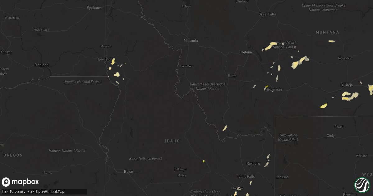
Hail Map in Idaho on June 1, 2015
Get this storm
June 1 map
$229
one time, instant access
Download today. No call, no setup
Keep the $229
Bought the map and want the full workflow? Apply the entire $229 to a subscription within 7 days. None of it is wasted.
Every map, not just this one
This buys you this map. Subscription and you get every map we run, in the markets you choose from a few cities to whole states to nationwide. Plus real-time alerts the moment a storm fires.
Contact data
Name, contact info, occupancy, even credit band for addresses in the footprint. You go from where it hit to who to call.
Become the source they trust
Unlimited branding weather history reports on demand. You already have the documented answer ready for the property owner, and you are the one who showed up with it.
Property data and RoofTrace estimates
Pull up any address you have got, its value and the exact code rules for that jurisdiction, straight from One Click Code. Then RoofTrace estimates the squares, pitch, and roof value, priced the way you price.
Storm reports in Idaho
Idaho
| Date | Description |
|---|---|
| 06/01/20156:54 PM CDT | Power poles are down. 4-6 inch trees are down. Power lines over houses and roads. Efforts underway to close roads until power lines are removed. |
| 06/01/20156:47 PM CDT | Reported that a neighbor's bathroom window was blown out. Based on other report and radar. |
| 06/01/20156:28 PM CDT | 1ft diameter tree broken as thunderstorm moved through. This is a correction from june 1st event. |
| 06/01/20156:20 PM CDT | Reported via social media to channel 3. Hail stones of various sizes covering the ground. Time based on radar. |
| 06/01/20156:00 PM CDT | Weston and preston experienced 45 to 50 mph wind gusts. Several power poles are down. No hail reported. |
| 06/01/20155:30 PM CDT | Spotter returned today to find some shingles ripped off home... A flipped fuel tank... Several downed trees and a mailbox that was ripped out. Time estimated from radar. (pih |
| 06/01/20155:15 PM CDT | 40 plus mph wind gusts. Three inch tree limbs are broken from trees. Vinyl fence has damage due to broken slats torn free of posts. |
| 06/01/20155:08 PM CDT | 50 to 60 mph winds removed limbs from trees and siding blown off of houses in mooreland. |
| 06/01/20155:00 PM CDT | Power was out as of 4pm. Part of larger power outages in blackfoot and nearby areas. 1350 people affected at one point. |
| 06/01/20155:00 PM CDT | Measured hail stone in chubbuck. |
| 06/01/20154:50 PM CDT | Submitted to idaho state journal via social media. Reported several large tree limbs down as well as some powerlines and road signs. Time based from radar. |
| 06/01/20154:45 PM CDT | Reported via the office facebook page of quarter to ping pong ball sized hail falling. Biggest stones were just under golf ball size. |
| 06/01/20154:45 PM CDT | Reported to the office fb page. Time based off radar and other reports. |
| 06/01/20154:45 PM CDT | Video submitted to the office fb page of quarter to ping pong ball sized hail falling. Biggest stones were just under golf ball size. |
| 06/01/20154:45 PM CDT | Reported to channel 6 via social media. Sized based from picture submitted. Tiem based on radar. |
| 06/01/20154:45 PM CDT | Reported via the idaho state journal facebook page. |
| 06/01/20154:43 PM CDT | Hail in chubbuck to include west chubbuck and ok ward park |
| 06/01/20154:30 PM CDT | 50mph winds along with 8in by 8ft branch blown down. |
| 06/01/20153:56 PM CDT | Gusts estimated. Visibility on hwy 20 from inl to arco reduced to 5 feet due to blowing dust. Highway patrol on higway controlling traffic. |
| 06/01/20153:25 PM CDT | A local report indicates 62 MPH wind near HOWE |
| 06/01/20152:50 PM CDT | Near leslie...idaho. |
| 06/01/20152:40 PM CDT | Started as 1 inch hail...then quickly decreased to 1/2 inch hail. |
| 05/31/201510:28 PM CDT | Trees damaged and metal roof damage |
| 05/31/20159:50 PM CDT | Reported via the office facebook page. Estimated to be the size of an older silver dollar coin. |
| 05/31/20159:30 PM CDT | Reported that a neighbor's bathroom window was blown out. Based on other report and radar. |
| 05/31/20159:05 PM CDT | 1ft diameter tree was broken as thunderstorm moved through. |
| 05/31/20158:40 PM CDT | Trees blown down on us 12 at mile marker 21 |
| 05/31/20158:40 PM CDT | Trees down on hwy 395. |
| 05/31/20158:40 PM CDT | Trees down on hwy 395 at mission creek road. |
All States Impacted by Hail Map on June 1, 2015
Cities Impacted by Hail Map on June 1, 2015
- Tioga, ND
- Mcgregor, ND
- Springer, NM
- Rogers, NM
- Hilliard, FL
- Lakeland, FL
- Hereford, TX
- Hastings, FL
- Lehr, ND
- Clermont, FL
- Oakland, FL
- Montverde, FL
- Winter Garden, FL
- Berthold, ND
- Manor, GA
- Waycross, GA
- New Castle, DE
- Manning, ND
- Belfield, ND
- Zap, ND
- Beulah, ND
- Pendleton, OR
- Tignall, GA
- Belle Fourche, SD
- Craigmont, ID
- Lapwai, ID
- Culdesac, ID
- Roberts, MT
- Red Lodge, MT
- Hanover, VA
- Aylett, VA
- Cornersville, TN
- Republican City, NE
- Dix, NE
- Annapolis, MD
- Edgewater, MD
- Bridgeton, NJ
- Elmer, NJ
- Woodstown, NJ
- Bunnell, FL
- La Grande, OR
- East Palatka, FL
- Sidney, NE
- Lodgepole, NE
- Alexandria, VA
- Wilmington, DE
- Gaylord, KS
- Monticello, FL
- Greenville, FL
- Cuervo, NM
- Santa Rosa, NM
- Winnsboro, SC
- Grant, NE
- Eustis, FL
- Wishek, ND
- Enterprise, OR
- Fairfield, ND
- Inchelium, WA
- Wall, SD
- Dalhart, TX
- Valdosta, GA
- Hazen, ND
- Garrison, ND
- Webster, FL
- Bard, NM
- Two Dot, MT
- Dodge, ND
- Halliday, ND
- Golden Valley, ND
- Dell, MT
- Pritchett, CO
- Hartley, TX
- Bottineau, ND
- Willow City, ND
- Souris, ND
- Smith Center, KS
- Bumpass, VA
- Haxtun, CO
- Holyoke, CO
- Champion, NE
- Wray, CO
- Yuma, CO
- Roanoke, VA
- Salem, VA
- Front Royal, VA
- Pocatello, ID
- American Falls, ID
- Culbertson, NE
- New Underwood, SD
- Owanka, SD
- Center, ND
- Medora, ND
- Rhame, ND
- Sentinel Butte, ND
- Franklin, NE
- Mays Landing, NJ
- Newtonville, NJ
- Landisville, NJ
- Minotola, NJ
- Hammonton, NJ
- Richland, NJ
- Egg Harbor City, NJ
- Buena, NJ
- Vineland, NJ
- Newfield, NJ
- Williamstown, NJ
- Tetonia, ID
- Firth, ID
- Poolesville, MD
- Ashburn, VA
- Sterling, VA
- Lodge Grass, MT
- Rougemont, NC
- Timberlake, NC
- Headland, AL
- Lance Creek, WY
- Naponee, NE
- Kensington, KS
- Bloomington, NE
- Riverton, NE
- Billings, MT
- Lake Mary, FL
- Sanford, FL
- Edinburg, VA
- Dundas, VA
- Blackstone, VA
- Steamboat Springs, CO
- Clark, CO
- White Sulphur Springs, MT
- Leesburg, VA
- Hockessin, DE
- Newark, DE
- Crook, CO
- Ovid, CO
- Sedgwick, CO
- Otis, CO
- Manhattan, MT
- Harrisburg, NE
- Strasburg, VA
- Maurertown, VA
- Bentonville, VA
- Fort Valley, VA
- Woodstock, VA
- Toms Brook, VA
- Logan, NM
- Tucumcari, NM
- Dillon, MT
- Lewiston, ID
- Belgrade, MT
- Covington, VA
- Curtis Bay, MD
- Pasadena, MD
- Warwick, ND
- Tolna, ND
- Pekin, ND
- Solen, ND
- Saint Anthony, ND
- Mandan, ND
- Kim, CO
- Avondale, CO
- Springdale, WA
- Coulee Dam, WA
- Herndon, KS
- Estero, FL
- Immokalee, FL
- Fort Myers, FL
- Nemo, SD
- Rapid City, SD
- Black Hawk, SD
- Deadwood, SD
- Piedmont, SD
- Sturgis, SD
- Ponchatoula, LA
- Mandeville, LA
- Pomeroy, WA
- Wilton, ND
- Wallowa, OR
- Warsaw, VA
- Callao, VA
- Farnham, VA
- Philip, SD
- Millersville, MD
- Severna Park, MD
- Friona, TX
- Potter, NE
- Hague, VA
- Kinsale, VA
- Port Royal, VA
- Spring Creek, NV
- Pilot Rock, OR
- Montello, NV
- Alma, NE
- Stamford, NE
- Orleans, NE
- Bedford, VA
- Chestertown, MD
- Millington, MD
- Kennedyville, MD
- Crumpton, MD
- Sudlersville, MD
- Galena, MD
- Parshall, ND
- Palermo, ND
- Plaza, ND
- Julesburg, CO
- Ranchester, WY
- Sheridan, WY
- Crestview, FL
- Eglin Afb, FL
- Byers, CO
- Mount Vernon, AL
- Chunchula, AL
- Citronelle, AL
- Saraland, AL
- Alachua, FL
- Gainesville, FL
- Salem, NJ
- Othello, WA
- Royal City, WA
- Driggs, ID
- Crow Agency, MT
- Hardin, MT
- Champlain, VA
- Colonial Beach, VA
- Hustle, VA
- Killdeer, ND
- Brooker, FL
- Pueblo, CO
- Grady, NM
- Elmer City, WA
- Troutville, VA
- Grover, CO
- Clovis, NM
- Shelley, ID
- Stanley, ND
- Wing, ND
- Sperryville, VA
- Washington, VA
- Longwood, FL
- Emporia, VA
- Skippers, VA
- Madison, FL
- Montvale, VA
- Blue Ridge, VA
- Ruther Glen, VA
- Tatum, NM
- Jetersville, VA
- Keller, WA
- Arthur, NE
- Ridgeway, SC
- Snowville, UT
- Malad City, ID
- Nara Visa, NM
- Arnold, MD
- Amherst, VA
- Washington, DC
- Ryder, ND
- Roseglen, ND
- Baxley, GA
- Micanopy, FL
- Archer, FL
- Kramer, ND
- Debary, FL
- Deland, FL
- Altamonte Springs, FL
- Deltona, FL
- Orange City, FL
- Winchester, ID
- Portales, NM
- Luray, VA
- Hazlehurst, GA
- Thaxton, VA
- Clearmont, WY
- Banner, WY
- Loretto, VA
- Ocate, NM
- Ulmer, SC
- Allendale, SC
- Fairfax, SC
- Bancroft, ID
- Clarksville, VA
- Boones Mill, VA
- Newkirk, NM
- Hot Springs, VA
- Summerville, OR
- Peetz, CO
- Rolette, ND
- Fort Gaines, GA
- Georgetown, GA
- Rogerson, ID
- Glen Allen, VA
- Henrico, VA
- McCarr, KY
- Delbarton, WV
- Matewan, WV
- Williamson, WV
- Elbert, CO
- Mullen, NE
- Newberry, FL
- High Springs, FL
- San Jon, NM
- Crewe, VA
- Burkeville, VA
- Amelia Court House, VA
- Bushnell, FL
- Floral City, FL
- Mcalister, NM
- Beaverdam, VA
- Colbert, WA
- Spokane, WA
- McCook, NE
- Asheboro, NC
- Honea Path, SC
- Flasher, ND
- Napoleon, ND
- Townsend, MT
- Deer Park, WA
- Colorado Springs, CO
- Ashton, ID
- Fountain Inn, SC
- Richardton, ND
- Hebron, ND
- Winter Haven, FL
- Dickinson, ND
- Gladstone, ND
- Pennsville, NJ
- Boone, CO
- Malta, ID
- Driscoll, ND
- Appomattox, VA
- Gladstone, VA
- Pryor, MT
- Matthews, GA
- Grass Range, MT
- Forest Grove, MT
- Roundup, MT
- Powhatan, VA
- Harrison, MT
- Three Forks, MT
- Cottonwood, ID
- Davidsonville, MD
- Riva, MD
- Gambrills, MD
- Crownsville, MD
- Adrian, TX
- Blackfoot, ID
- Carpenter, WY
- Auburndale, FL
- Orlando, FL
- Christmas, FL
- Great Falls, SC
- Lancaster, SC
- Statesboro, GA
- New Town, ND
- Barboursville, VA
- Gordonsville, VA
- Rice, WA
- Gifford, WA
- Jackpot, NV
- New Salem, ND
- Dunn Center, ND
- Mead, WA
- Oviedo, FL
- Geneva, FL
- Polk City, FL
- Pine Bluffs, WY
- Du Pont, GA
- Wasta, SD
- Oakley, ID
- Wetmore, CO
- Florence, CO
- Bear, DE
- Laurel, MT
- Arapahoe, CO
- Eaton Park, FL
- Arrington, VA
- Holt, FL
- Ekalaka, MT
- Blythewood, SC
- Mackay, ID
- Hillsborough, NC
- Venango, NE
- Trenton, NE
- Gladstone, NM
- Elberton, GA
- Pikeville, KY
- McRae Helena, GA
- Jacksonville, GA
- Gurley, NE
- Joliet, MT
- Meacham, OR
- Ringling, MT
- Zolfo Springs, FL
- Blackstock, SC
- Ashley, ND
- Benkelman, NE
- Decker, MT
- Martinsdale, MT
- Hardy, VA
- Milford, VA
- Montross, VA
- Tappahannock, VA
- Newtown, VA
- Bozeman, MT
- Lake Park, GA
- Steele, ND
- Soperton, GA
- Alliance, NE
- Kimball, NE
- Broxton, GA
- New Providence, PA
- Strasburg, PA
- Quarryville, PA
- Drumore, PA
- Willow Street, PA
- Blythe, GA
- Stephens City, VA
- Middletown, VA
- Bismarck, ND
- Bartow, FL
- Cove, OR
- Richmond, VA
- Stratton, NE
- Harlowton, MT
- Wauneta, NE
- Palisade, NE
- Oakton, VA
- Carthage, NC
- Nine Mile Falls, WA
- Panther, WV
- De Leon Springs, FL
- Abbeville, AL
- Apopka, FL
- Bullock, NC
- Oxford, NC
- McKenney, VA
- Howey In The Hills, FL
- Astatula, FL
- Crozet, VA
- Charlottesville, VA
- Lusk, WY
- Park Valley, UT
- Big Springs, NE
- Vinton, VA
- Goodview, VA
- Yalaha, FL
- Windermere, FL
- Tavares, FL
- Glen Burnie, MD
- Clopton, AL
- Bridgeport, NE
- Haigler, NE
- Holly, CO
- Pompeys Pillar, MT
- Lottsburg, VA
- Defuniak Springs, FL
- Ponce De Leon, FL
- Germantown, MD
- Chappell, NE
- Great Falls, VA
- Madison, AL
- Amherst, CO
- Gackle, ND
- Alamo, GA
- Bovina, TX
- Hot Springs, SD
- Kenmare, ND
- Winchester, VA
- Fredonia, ND
- Wilsons, VA
- Asotin, WA
- Sanderson, FL
- Baker, MT
- Cozad, NE
- Wake Forest, NC
- Lake Butler, FL
- Wrens, GA
- Kinnear, WY
- Athens, TN
- Cloverdale, VA
- Carson, ND
- Almont, ND
- Folkston, GA
- Wray, GA
- Hayden, CO
- Dade City, FL
- Spruce Pine, NC
- Okeechobee, FL
- Vero Beach, FL
- Clayton, AL
- Madrid, NE
- Dameron, MD
- Ridge, MD
- Washburn, ND
- Tarrytown, GA
- Ailey, GA
- Bonifay, FL
- Scotland, MD
- Dickerson, MD
- Boyds, MD
- Herndon, VA
- Twin Falls, ID
- Woodruff, SC
- Hawk Springs, WY
- Mansfield, WA
- Omar, WV
- Hawthorne, FL
- Toston, MT
- Sylvania, GA
- Labelle, FL
- Donalds, SC
- Arcadia, FL
- Jay Em, WY
- Maxbass, ND
- Ashland, VA
- Callaway, MD
- Patuxent River, MD
- California, MD
- Lexington Park, MD
- Great Mills, MD
- Heath Springs, SC
- Forest Hills, KY
- Belfry, KY
- Hardy, KY


