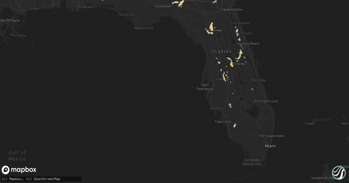
Hail Map in Florida on June 1, 2015
Get this storm
June 1 map
$229
one time, instant access
Download today. No call, no setup
Keep the $229
Bought the map and want the full workflow? Apply the entire $229 to a subscription within 7 days. None of it is wasted.
Every map, not just this one
This buys you this map. Subscription and you get every map we run, in the markets you choose from a few cities to whole states to nationwide. Plus real-time alerts the moment a storm fires.
Contact data
Name, contact info, occupancy, even credit band for addresses in the footprint. You go from where it hit to who to call.
Become the source they trust
Unlimited branding weather history reports on demand. You already have the documented answer ready for the property owner, and you are the one who showed up with it.
Property data and RoofTrace estimates
Pull up any address you have got, its value and the exact code rules for that jurisdiction, straight from One Click Code. Then RoofTrace estimates the squares, pitch, and roof value, priced the way you price.
Storm reports in Florida
Florida
| Date | Description |
|---|---|
| 06/01/20154:59 PM CDT | A tree was blown down at the intersection of county road 250 and county road 229. |
| 06/01/20154:45 PM CDT | Local broadcast media relayed pictures of a large tree down in lakeland. |
| 06/01/20154:43 PM CDT | Broadcast media relayed photos of golf ball sized hail in oakland. |
| 06/01/20154:40 PM CDT | Public reported quarter sized hail near the intersection of oakland road and tubb street in oakland. |
| 06/01/20154:02 PM CDT | A local report indicates 1.75 inch wind near 4 SE ALACHUA |
| 06/01/20153:20 PM CDT | Corrected storm report. Skywarn spotter reported nickel to quarter sized hail in wekiva springs. |
| 06/01/20153:15 PM CDT | Broadcast media relayed photo of a fallen large tree on markham woods rd south of lake mary blvd. Time estimated by radar. |
| 06/01/20153:03 PM CDT | Storm spotter reports quarter-sized hail near the intersection of lake emma road and lake mary boulevard in lake mary. Also estimated wind gusts of 45 to 50 mph. |
| 06/01/20153:00 PM CDT | Live oaks snapped about 25 ft above ground level due to strong thunderstorm winds. |
| 06/01/20152:50 PM CDT | Public reported via social media quarter sized hail near the intersection of i-4 and sr-46 in sanford. |
| 06/01/20152:30 PM CDT | Tree down at highway 150 and highway 145. |
| 06/01/20152:25 PM CDT | Tree down on cherry lake circle |
| 06/01/20152:15 PM CDT | Broadcast media relayed several pictures of large tree branches down in orange city and deltona. Cfnews-13 reported a large tree branch fell on a powerline outside of a |
| 06/01/20152:10 PM CDT | A roof was damaged by thunderstorm winds at 5431 ne 35th street in ocala. Unconfirmed report of a rope funnel cloud in the area around that time. |
| 06/01/20152:00 PM CDT | Large tree down in downtown greenville. |
| 06/01/20152:00 PM CDT | A local report indicates 1.00 inch wind near 9 SW BUNNELL |
| 06/01/20152:00 PM CDT | Tree down near i-10 at mile marker 246 |
| 06/01/20151:35 PM CDT | A tree was blown down in flagler estates. The time of damage was based on radar. |
| 06/01/20151:25 PM CDT | Viewer report of 10 trees down just north of monticello |
All States Impacted by Hail Map on June 1, 2015
Cities Impacted by Hail Map on June 1, 2015
- Tioga, ND
- Mcgregor, ND
- Springer, NM
- Rogers, NM
- Hilliard, FL
- Lakeland, FL
- Hereford, TX
- Hastings, FL
- Lehr, ND
- Clermont, FL
- Oakland, FL
- Montverde, FL
- Winter Garden, FL
- Berthold, ND
- Manor, GA
- Waycross, GA
- New Castle, DE
- Manning, ND
- Belfield, ND
- Zap, ND
- Beulah, ND
- Pendleton, OR
- Tignall, GA
- Belle Fourche, SD
- Craigmont, ID
- Lapwai, ID
- Culdesac, ID
- Roberts, MT
- Red Lodge, MT
- Hanover, VA
- Aylett, VA
- Cornersville, TN
- Republican City, NE
- Dix, NE
- Annapolis, MD
- Edgewater, MD
- Bridgeton, NJ
- Elmer, NJ
- Woodstown, NJ
- Bunnell, FL
- La Grande, OR
- East Palatka, FL
- Sidney, NE
- Lodgepole, NE
- Alexandria, VA
- Wilmington, DE
- Gaylord, KS
- Monticello, FL
- Greenville, FL
- Cuervo, NM
- Santa Rosa, NM
- Winnsboro, SC
- Grant, NE
- Eustis, FL
- Wishek, ND
- Enterprise, OR
- Fairfield, ND
- Inchelium, WA
- Wall, SD
- Dalhart, TX
- Valdosta, GA
- Hazen, ND
- Garrison, ND
- Webster, FL
- Bard, NM
- Two Dot, MT
- Dodge, ND
- Halliday, ND
- Golden Valley, ND
- Dell, MT
- Pritchett, CO
- Hartley, TX
- Bottineau, ND
- Willow City, ND
- Souris, ND
- Smith Center, KS
- Bumpass, VA
- Haxtun, CO
- Holyoke, CO
- Champion, NE
- Wray, CO
- Yuma, CO
- Roanoke, VA
- Salem, VA
- Front Royal, VA
- Pocatello, ID
- American Falls, ID
- Culbertson, NE
- New Underwood, SD
- Owanka, SD
- Center, ND
- Medora, ND
- Rhame, ND
- Sentinel Butte, ND
- Franklin, NE
- Mays Landing, NJ
- Newtonville, NJ
- Landisville, NJ
- Minotola, NJ
- Hammonton, NJ
- Richland, NJ
- Egg Harbor City, NJ
- Buena, NJ
- Vineland, NJ
- Newfield, NJ
- Williamstown, NJ
- Tetonia, ID
- Firth, ID
- Poolesville, MD
- Ashburn, VA
- Sterling, VA
- Lodge Grass, MT
- Rougemont, NC
- Timberlake, NC
- Headland, AL
- Lance Creek, WY
- Naponee, NE
- Kensington, KS
- Bloomington, NE
- Riverton, NE
- Billings, MT
- Lake Mary, FL
- Sanford, FL
- Edinburg, VA
- Dundas, VA
- Blackstone, VA
- Steamboat Springs, CO
- Clark, CO
- White Sulphur Springs, MT
- Leesburg, VA
- Hockessin, DE
- Newark, DE
- Crook, CO
- Ovid, CO
- Sedgwick, CO
- Otis, CO
- Manhattan, MT
- Harrisburg, NE
- Strasburg, VA
- Maurertown, VA
- Bentonville, VA
- Fort Valley, VA
- Woodstock, VA
- Toms Brook, VA
- Logan, NM
- Tucumcari, NM
- Dillon, MT
- Lewiston, ID
- Belgrade, MT
- Covington, VA
- Curtis Bay, MD
- Pasadena, MD
- Warwick, ND
- Tolna, ND
- Pekin, ND
- Solen, ND
- Saint Anthony, ND
- Mandan, ND
- Kim, CO
- Avondale, CO
- Springdale, WA
- Coulee Dam, WA
- Herndon, KS
- Estero, FL
- Immokalee, FL
- Fort Myers, FL
- Nemo, SD
- Rapid City, SD
- Black Hawk, SD
- Deadwood, SD
- Piedmont, SD
- Sturgis, SD
- Ponchatoula, LA
- Mandeville, LA
- Pomeroy, WA
- Wilton, ND
- Wallowa, OR
- Warsaw, VA
- Callao, VA
- Farnham, VA
- Philip, SD
- Millersville, MD
- Severna Park, MD
- Friona, TX
- Potter, NE
- Hague, VA
- Kinsale, VA
- Port Royal, VA
- Spring Creek, NV
- Pilot Rock, OR
- Montello, NV
- Alma, NE
- Stamford, NE
- Orleans, NE
- Bedford, VA
- Chestertown, MD
- Millington, MD
- Kennedyville, MD
- Crumpton, MD
- Sudlersville, MD
- Galena, MD
- Parshall, ND
- Palermo, ND
- Plaza, ND
- Julesburg, CO
- Ranchester, WY
- Sheridan, WY
- Crestview, FL
- Eglin Afb, FL
- Byers, CO
- Mount Vernon, AL
- Chunchula, AL
- Citronelle, AL
- Saraland, AL
- Alachua, FL
- Gainesville, FL
- Salem, NJ
- Othello, WA
- Royal City, WA
- Driggs, ID
- Crow Agency, MT
- Hardin, MT
- Champlain, VA
- Colonial Beach, VA
- Hustle, VA
- Killdeer, ND
- Brooker, FL
- Pueblo, CO
- Grady, NM
- Elmer City, WA
- Troutville, VA
- Grover, CO
- Clovis, NM
- Shelley, ID
- Stanley, ND
- Wing, ND
- Sperryville, VA
- Washington, VA
- Longwood, FL
- Emporia, VA
- Skippers, VA
- Madison, FL
- Montvale, VA
- Blue Ridge, VA
- Ruther Glen, VA
- Tatum, NM
- Jetersville, VA
- Keller, WA
- Arthur, NE
- Ridgeway, SC
- Snowville, UT
- Malad City, ID
- Nara Visa, NM
- Arnold, MD
- Amherst, VA
- Washington, DC
- Ryder, ND
- Roseglen, ND
- Baxley, GA
- Micanopy, FL
- Archer, FL
- Kramer, ND
- Debary, FL
- Deland, FL
- Altamonte Springs, FL
- Deltona, FL
- Orange City, FL
- Winchester, ID
- Portales, NM
- Luray, VA
- Hazlehurst, GA
- Thaxton, VA
- Clearmont, WY
- Banner, WY
- Loretto, VA
- Ocate, NM
- Ulmer, SC
- Allendale, SC
- Fairfax, SC
- Bancroft, ID
- Clarksville, VA
- Boones Mill, VA
- Newkirk, NM
- Hot Springs, VA
- Summerville, OR
- Peetz, CO
- Rolette, ND
- Fort Gaines, GA
- Georgetown, GA
- Rogerson, ID
- Glen Allen, VA
- Henrico, VA
- McCarr, KY
- Delbarton, WV
- Matewan, WV
- Williamson, WV
- Elbert, CO
- Mullen, NE
- Newberry, FL
- High Springs, FL
- San Jon, NM
- Crewe, VA
- Burkeville, VA
- Amelia Court House, VA
- Bushnell, FL
- Floral City, FL
- Mcalister, NM
- Beaverdam, VA
- Colbert, WA
- Spokane, WA
- McCook, NE
- Asheboro, NC
- Honea Path, SC
- Flasher, ND
- Napoleon, ND
- Townsend, MT
- Deer Park, WA
- Colorado Springs, CO
- Ashton, ID
- Fountain Inn, SC
- Richardton, ND
- Hebron, ND
- Winter Haven, FL
- Dickinson, ND
- Gladstone, ND
- Pennsville, NJ
- Boone, CO
- Malta, ID
- Driscoll, ND
- Appomattox, VA
- Gladstone, VA
- Pryor, MT
- Matthews, GA
- Grass Range, MT
- Forest Grove, MT
- Roundup, MT
- Powhatan, VA
- Harrison, MT
- Three Forks, MT
- Cottonwood, ID
- Davidsonville, MD
- Riva, MD
- Gambrills, MD
- Crownsville, MD
- Adrian, TX
- Blackfoot, ID
- Carpenter, WY
- Auburndale, FL
- Orlando, FL
- Christmas, FL
- Great Falls, SC
- Lancaster, SC
- Statesboro, GA
- New Town, ND
- Barboursville, VA
- Gordonsville, VA
- Rice, WA
- Gifford, WA
- Jackpot, NV
- New Salem, ND
- Dunn Center, ND
- Mead, WA
- Oviedo, FL
- Geneva, FL
- Polk City, FL
- Pine Bluffs, WY
- Du Pont, GA
- Wasta, SD
- Oakley, ID
- Wetmore, CO
- Florence, CO
- Bear, DE
- Laurel, MT
- Arapahoe, CO
- Eaton Park, FL
- Arrington, VA
- Holt, FL
- Ekalaka, MT
- Blythewood, SC
- Mackay, ID
- Hillsborough, NC
- Venango, NE
- Trenton, NE
- Gladstone, NM
- Elberton, GA
- Pikeville, KY
- McRae Helena, GA
- Jacksonville, GA
- Gurley, NE
- Joliet, MT
- Meacham, OR
- Ringling, MT
- Zolfo Springs, FL
- Blackstock, SC
- Ashley, ND
- Benkelman, NE
- Decker, MT
- Martinsdale, MT
- Hardy, VA
- Milford, VA
- Montross, VA
- Tappahannock, VA
- Newtown, VA
- Bozeman, MT
- Lake Park, GA
- Steele, ND
- Soperton, GA
- Alliance, NE
- Kimball, NE
- Broxton, GA
- New Providence, PA
- Strasburg, PA
- Quarryville, PA
- Drumore, PA
- Willow Street, PA
- Blythe, GA
- Stephens City, VA
- Middletown, VA
- Bismarck, ND
- Bartow, FL
- Cove, OR
- Richmond, VA
- Stratton, NE
- Harlowton, MT
- Wauneta, NE
- Palisade, NE
- Oakton, VA
- Carthage, NC
- Nine Mile Falls, WA
- Panther, WV
- De Leon Springs, FL
- Abbeville, AL
- Apopka, FL
- Bullock, NC
- Oxford, NC
- McKenney, VA
- Howey In The Hills, FL
- Astatula, FL
- Crozet, VA
- Charlottesville, VA
- Lusk, WY
- Park Valley, UT
- Big Springs, NE
- Vinton, VA
- Goodview, VA
- Yalaha, FL
- Windermere, FL
- Tavares, FL
- Glen Burnie, MD
- Clopton, AL
- Bridgeport, NE
- Haigler, NE
- Holly, CO
- Pompeys Pillar, MT
- Lottsburg, VA
- Defuniak Springs, FL
- Ponce De Leon, FL
- Germantown, MD
- Chappell, NE
- Great Falls, VA
- Madison, AL
- Amherst, CO
- Gackle, ND
- Alamo, GA
- Bovina, TX
- Hot Springs, SD
- Kenmare, ND
- Winchester, VA
- Fredonia, ND
- Wilsons, VA
- Asotin, WA
- Sanderson, FL
- Baker, MT
- Cozad, NE
- Wake Forest, NC
- Lake Butler, FL
- Wrens, GA
- Kinnear, WY
- Athens, TN
- Cloverdale, VA
- Carson, ND
- Almont, ND
- Folkston, GA
- Wray, GA
- Hayden, CO
- Dade City, FL
- Spruce Pine, NC
- Okeechobee, FL
- Vero Beach, FL
- Clayton, AL
- Madrid, NE
- Dameron, MD
- Ridge, MD
- Washburn, ND
- Tarrytown, GA
- Ailey, GA
- Bonifay, FL
- Scotland, MD
- Dickerson, MD
- Boyds, MD
- Herndon, VA
- Twin Falls, ID
- Woodruff, SC
- Hawk Springs, WY
- Mansfield, WA
- Omar, WV
- Hawthorne, FL
- Toston, MT
- Sylvania, GA
- Labelle, FL
- Donalds, SC
- Arcadia, FL
- Jay Em, WY
- Maxbass, ND
- Ashland, VA
- Callaway, MD
- Patuxent River, MD
- California, MD
- Lexington Park, MD
- Great Mills, MD
- Heath Springs, SC
- Forest Hills, KY
- Belfry, KY
- Hardy, KY


