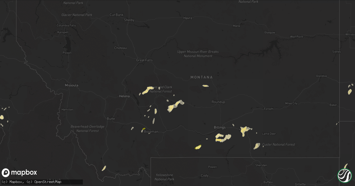
Hail Map in Montana on June 1, 2015
Get this storm
June 1 map
$229
one time, instant access
Download today. No call, no setup
Keep the $229
Bought the map and want the full workflow? Apply the entire $229 to a subscription within 7 days. None of it is wasted.
Every map, not just this one
This buys you this map. Subscription and you get every map we run, in the markets you choose from a few cities to whole states to nationwide. Plus real-time alerts the moment a storm fires.
Contact data
Name, contact info, occupancy, even credit band for addresses in the footprint. You go from where it hit to who to call.
Become the source they trust
Unlimited branding weather history reports on demand. You already have the documented answer ready for the property owner, and you are the one who showed up with it.
Property data and RoofTrace estimates
Pull up any address you have got, its value and the exact code rules for that jurisdiction, straight from One Click Code. Then RoofTrace estimates the squares, pitch, and roof value, priced the way you price.
Storm reports in Montana
Montana
| Date | Description |
|---|---|
| 06/01/20156:20 PM CDT | Public reported hail slightly larger than quarters. |
| 06/01/20156:20 PM CDT | Quarter hail reported at koa campground. |
| 06/01/20156:00 PM CDT | A local report indicates 62 MPH wind near 4 N WILSALL |
| 06/01/20156:00 PM CDT | 64 mph wind gust at the deep creek raws location on highway 12. |
| 06/01/20155:11 PM CDT | 58 mph wind gust at the ennis fish hatchery. |
| 06/01/20155:06 PM CDT | Estimated quarter size hail near church hill. Time and exact location of event is estimated. |
| 06/01/201512:59 PM CDT | Also with heavy rain and nickel hail. |
| 06/01/201512:59 AM CDT | Also with heavy rain and nickel hail. |
| 05/31/201510:48 PM CDT | Some quarter size hail with most dime size hail. |
| 05/31/201510:27 PM CDT | A local report indicates 61 MPH wind near 7 NNE OTTER |
| 05/31/20159:30 PM CDT | A local report indicates 60 MPH wind near HYSHAM |
| 05/31/20159:30 PM CDT | Winds estimated. |
| 05/31/20157:58 PM CDT | A local report indicates 60 MPH wind near JUDITH GAP |
| 05/31/20157:19 PM CDT | Ground covered with small hail. |
All States Impacted by Hail Map on June 1, 2015
Cities Impacted by Hail Map on June 1, 2015
- Tioga, ND
- Mcgregor, ND
- Springer, NM
- Rogers, NM
- Hilliard, FL
- Lakeland, FL
- Hereford, TX
- Hastings, FL
- Lehr, ND
- Clermont, FL
- Oakland, FL
- Montverde, FL
- Winter Garden, FL
- Berthold, ND
- Manor, GA
- Waycross, GA
- New Castle, DE
- Manning, ND
- Belfield, ND
- Zap, ND
- Beulah, ND
- Pendleton, OR
- Tignall, GA
- Belle Fourche, SD
- Craigmont, ID
- Lapwai, ID
- Culdesac, ID
- Roberts, MT
- Red Lodge, MT
- Hanover, VA
- Aylett, VA
- Cornersville, TN
- Republican City, NE
- Dix, NE
- Annapolis, MD
- Edgewater, MD
- Bridgeton, NJ
- Elmer, NJ
- Woodstown, NJ
- Bunnell, FL
- La Grande, OR
- East Palatka, FL
- Sidney, NE
- Lodgepole, NE
- Alexandria, VA
- Wilmington, DE
- Gaylord, KS
- Monticello, FL
- Greenville, FL
- Cuervo, NM
- Santa Rosa, NM
- Winnsboro, SC
- Grant, NE
- Eustis, FL
- Wishek, ND
- Enterprise, OR
- Fairfield, ND
- Inchelium, WA
- Wall, SD
- Dalhart, TX
- Valdosta, GA
- Hazen, ND
- Garrison, ND
- Webster, FL
- Bard, NM
- Two Dot, MT
- Dodge, ND
- Halliday, ND
- Golden Valley, ND
- Dell, MT
- Pritchett, CO
- Hartley, TX
- Bottineau, ND
- Willow City, ND
- Souris, ND
- Smith Center, KS
- Bumpass, VA
- Haxtun, CO
- Holyoke, CO
- Champion, NE
- Wray, CO
- Yuma, CO
- Roanoke, VA
- Salem, VA
- Front Royal, VA
- Pocatello, ID
- American Falls, ID
- Culbertson, NE
- New Underwood, SD
- Owanka, SD
- Center, ND
- Medora, ND
- Rhame, ND
- Sentinel Butte, ND
- Franklin, NE
- Mays Landing, NJ
- Newtonville, NJ
- Landisville, NJ
- Minotola, NJ
- Hammonton, NJ
- Richland, NJ
- Egg Harbor City, NJ
- Buena, NJ
- Vineland, NJ
- Newfield, NJ
- Williamstown, NJ
- Tetonia, ID
- Firth, ID
- Poolesville, MD
- Ashburn, VA
- Sterling, VA
- Lodge Grass, MT
- Rougemont, NC
- Timberlake, NC
- Headland, AL
- Lance Creek, WY
- Naponee, NE
- Kensington, KS
- Bloomington, NE
- Riverton, NE
- Billings, MT
- Lake Mary, FL
- Sanford, FL
- Edinburg, VA
- Dundas, VA
- Blackstone, VA
- Steamboat Springs, CO
- Clark, CO
- White Sulphur Springs, MT
- Leesburg, VA
- Hockessin, DE
- Newark, DE
- Crook, CO
- Ovid, CO
- Sedgwick, CO
- Otis, CO
- Manhattan, MT
- Harrisburg, NE
- Strasburg, VA
- Maurertown, VA
- Bentonville, VA
- Fort Valley, VA
- Woodstock, VA
- Toms Brook, VA
- Logan, NM
- Tucumcari, NM
- Dillon, MT
- Lewiston, ID
- Belgrade, MT
- Covington, VA
- Curtis Bay, MD
- Pasadena, MD
- Warwick, ND
- Tolna, ND
- Pekin, ND
- Solen, ND
- Saint Anthony, ND
- Mandan, ND
- Kim, CO
- Avondale, CO
- Springdale, WA
- Coulee Dam, WA
- Herndon, KS
- Estero, FL
- Immokalee, FL
- Fort Myers, FL
- Nemo, SD
- Rapid City, SD
- Black Hawk, SD
- Deadwood, SD
- Piedmont, SD
- Sturgis, SD
- Ponchatoula, LA
- Mandeville, LA
- Pomeroy, WA
- Wilton, ND
- Wallowa, OR
- Warsaw, VA
- Callao, VA
- Farnham, VA
- Philip, SD
- Millersville, MD
- Severna Park, MD
- Friona, TX
- Potter, NE
- Hague, VA
- Kinsale, VA
- Port Royal, VA
- Spring Creek, NV
- Pilot Rock, OR
- Montello, NV
- Alma, NE
- Stamford, NE
- Orleans, NE
- Bedford, VA
- Chestertown, MD
- Millington, MD
- Kennedyville, MD
- Crumpton, MD
- Sudlersville, MD
- Galena, MD
- Parshall, ND
- Palermo, ND
- Plaza, ND
- Julesburg, CO
- Ranchester, WY
- Sheridan, WY
- Crestview, FL
- Eglin Afb, FL
- Byers, CO
- Mount Vernon, AL
- Chunchula, AL
- Citronelle, AL
- Saraland, AL
- Alachua, FL
- Gainesville, FL
- Salem, NJ
- Othello, WA
- Royal City, WA
- Driggs, ID
- Crow Agency, MT
- Hardin, MT
- Champlain, VA
- Colonial Beach, VA
- Hustle, VA
- Killdeer, ND
- Brooker, FL
- Pueblo, CO
- Grady, NM
- Elmer City, WA
- Troutville, VA
- Grover, CO
- Clovis, NM
- Shelley, ID
- Stanley, ND
- Wing, ND
- Sperryville, VA
- Washington, VA
- Longwood, FL
- Emporia, VA
- Skippers, VA
- Madison, FL
- Montvale, VA
- Blue Ridge, VA
- Ruther Glen, VA
- Tatum, NM
- Jetersville, VA
- Keller, WA
- Arthur, NE
- Ridgeway, SC
- Snowville, UT
- Malad City, ID
- Nara Visa, NM
- Arnold, MD
- Amherst, VA
- Washington, DC
- Ryder, ND
- Roseglen, ND
- Baxley, GA
- Micanopy, FL
- Archer, FL
- Kramer, ND
- Debary, FL
- Deland, FL
- Altamonte Springs, FL
- Deltona, FL
- Orange City, FL
- Winchester, ID
- Portales, NM
- Luray, VA
- Hazlehurst, GA
- Thaxton, VA
- Clearmont, WY
- Banner, WY
- Loretto, VA
- Ocate, NM
- Ulmer, SC
- Allendale, SC
- Fairfax, SC
- Bancroft, ID
- Clarksville, VA
- Boones Mill, VA
- Newkirk, NM
- Hot Springs, VA
- Summerville, OR
- Peetz, CO
- Rolette, ND
- Fort Gaines, GA
- Georgetown, GA
- Rogerson, ID
- Glen Allen, VA
- Henrico, VA
- McCarr, KY
- Delbarton, WV
- Matewan, WV
- Williamson, WV
- Elbert, CO
- Mullen, NE
- Newberry, FL
- High Springs, FL
- San Jon, NM
- Crewe, VA
- Burkeville, VA
- Amelia Court House, VA
- Bushnell, FL
- Floral City, FL
- Mcalister, NM
- Beaverdam, VA
- Colbert, WA
- Spokane, WA
- McCook, NE
- Asheboro, NC
- Honea Path, SC
- Flasher, ND
- Napoleon, ND
- Townsend, MT
- Deer Park, WA
- Colorado Springs, CO
- Ashton, ID
- Fountain Inn, SC
- Richardton, ND
- Hebron, ND
- Winter Haven, FL
- Dickinson, ND
- Gladstone, ND
- Pennsville, NJ
- Boone, CO
- Malta, ID
- Driscoll, ND
- Appomattox, VA
- Gladstone, VA
- Pryor, MT
- Matthews, GA
- Grass Range, MT
- Forest Grove, MT
- Roundup, MT
- Powhatan, VA
- Harrison, MT
- Three Forks, MT
- Cottonwood, ID
- Davidsonville, MD
- Riva, MD
- Gambrills, MD
- Crownsville, MD
- Adrian, TX
- Blackfoot, ID
- Carpenter, WY
- Auburndale, FL
- Orlando, FL
- Christmas, FL
- Great Falls, SC
- Lancaster, SC
- Statesboro, GA
- New Town, ND
- Barboursville, VA
- Gordonsville, VA
- Rice, WA
- Gifford, WA
- Jackpot, NV
- New Salem, ND
- Dunn Center, ND
- Mead, WA
- Oviedo, FL
- Geneva, FL
- Polk City, FL
- Pine Bluffs, WY
- Du Pont, GA
- Wasta, SD
- Oakley, ID
- Wetmore, CO
- Florence, CO
- Bear, DE
- Laurel, MT
- Arapahoe, CO
- Eaton Park, FL
- Arrington, VA
- Holt, FL
- Ekalaka, MT
- Blythewood, SC
- Mackay, ID
- Hillsborough, NC
- Venango, NE
- Trenton, NE
- Gladstone, NM
- Elberton, GA
- Pikeville, KY
- McRae Helena, GA
- Jacksonville, GA
- Gurley, NE
- Joliet, MT
- Meacham, OR
- Ringling, MT
- Zolfo Springs, FL
- Blackstock, SC
- Ashley, ND
- Benkelman, NE
- Decker, MT
- Martinsdale, MT
- Hardy, VA
- Milford, VA
- Montross, VA
- Tappahannock, VA
- Newtown, VA
- Bozeman, MT
- Lake Park, GA
- Steele, ND
- Soperton, GA
- Alliance, NE
- Kimball, NE
- Broxton, GA
- New Providence, PA
- Strasburg, PA
- Quarryville, PA
- Drumore, PA
- Willow Street, PA
- Blythe, GA
- Stephens City, VA
- Middletown, VA
- Bismarck, ND
- Bartow, FL
- Cove, OR
- Richmond, VA
- Stratton, NE
- Harlowton, MT
- Wauneta, NE
- Palisade, NE
- Oakton, VA
- Carthage, NC
- Nine Mile Falls, WA
- Panther, WV
- De Leon Springs, FL
- Abbeville, AL
- Apopka, FL
- Bullock, NC
- Oxford, NC
- McKenney, VA
- Howey In The Hills, FL
- Astatula, FL
- Crozet, VA
- Charlottesville, VA
- Lusk, WY
- Park Valley, UT
- Big Springs, NE
- Vinton, VA
- Goodview, VA
- Yalaha, FL
- Windermere, FL
- Tavares, FL
- Glen Burnie, MD
- Clopton, AL
- Bridgeport, NE
- Haigler, NE
- Holly, CO
- Pompeys Pillar, MT
- Lottsburg, VA
- Defuniak Springs, FL
- Ponce De Leon, FL
- Germantown, MD
- Chappell, NE
- Great Falls, VA
- Madison, AL
- Amherst, CO
- Gackle, ND
- Alamo, GA
- Bovina, TX
- Hot Springs, SD
- Kenmare, ND
- Winchester, VA
- Fredonia, ND
- Wilsons, VA
- Asotin, WA
- Sanderson, FL
- Baker, MT
- Cozad, NE
- Wake Forest, NC
- Lake Butler, FL
- Wrens, GA
- Kinnear, WY
- Athens, TN
- Cloverdale, VA
- Carson, ND
- Almont, ND
- Folkston, GA
- Wray, GA
- Hayden, CO
- Dade City, FL
- Spruce Pine, NC
- Okeechobee, FL
- Vero Beach, FL
- Clayton, AL
- Madrid, NE
- Dameron, MD
- Ridge, MD
- Washburn, ND
- Tarrytown, GA
- Ailey, GA
- Bonifay, FL
- Scotland, MD
- Dickerson, MD
- Boyds, MD
- Herndon, VA
- Twin Falls, ID
- Woodruff, SC
- Hawk Springs, WY
- Mansfield, WA
- Omar, WV
- Hawthorne, FL
- Toston, MT
- Sylvania, GA
- Labelle, FL
- Donalds, SC
- Arcadia, FL
- Jay Em, WY
- Maxbass, ND
- Ashland, VA
- Callaway, MD
- Patuxent River, MD
- California, MD
- Lexington Park, MD
- Great Mills, MD
- Heath Springs, SC
- Forest Hills, KY
- Belfry, KY
- Hardy, KY


