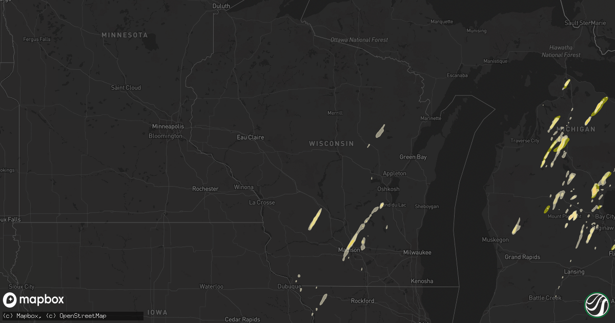
Hail Map in Wisconsin on May 30, 2013
Get this storm
May 30 map
$229
one time, instant access
Download today. No call, no setup
Keep the $229
Bought the map and want the full workflow? Apply the entire $229 to a subscription within 7 days. None of it is wasted.
Every map, not just this one
This buys you this map. Subscription and you get every map we run, in the markets you choose from a few cities to whole states to nationwide. Plus real-time alerts the moment a storm fires.
Contact data
Name, contact info, occupancy, even credit band for addresses in the footprint. You go from where it hit to who to call.
Become the source they trust
Unlimited branding weather history reports on demand. You already have the documented answer ready for the property owner, and you are the one who showed up with it.
Property data and RoofTrace estimates
Pull up any address you have got, its value and the exact code rules for that jurisdiction, straight from One Click Code. Then RoofTrace estimates the squares, pitch, and roof value, priced the way you price.
Storm reports in Wisconsin
Wisconsin
| Date | Description |
|---|---|
| 05/30/20136:50 PM CDT | Roof off of a farm shed and a few oak trees down. Time based on radar. |
| 05/30/20136:50 PM CDT | Albany school meso site. Also trees down all over monroe to albany. |
| 05/30/20136:48 PM CDT | A couple trees and powerlines down. |
| 05/30/20136:46 PM CDT | 13 inch diameter trees down on ferry st between 11th and west ave...and on 6th street |
| 05/30/20136:39 PM CDT | At least two large trees damaged/down along main street in juda. Very large branch dropped in parking lot... Another tree down and blocking main street. Time estimated |
| 05/30/20136:25 PM CDT | Along highway 56 |
| 05/30/20136:10 PM CDT | Thunderstorm wind gusts 60 to 65 mph. |
| 05/30/20136:00 PM CDT | Half dozen trees down...up to 2 feet in diameter. Time estimated. |
| 05/30/20135:59 PM CDT | A local report indicates 60 MPH wind near 5 S EASTMAN |
| 05/30/20135:32 PM CDT | A local report indicates 60 MPH wind near TIGERTON |
| 05/30/20134:50 PM CDT | Semi blown on its side. Time approx. |
| 05/30/20134:27 PM CDT | Trees and power lines down |
| 05/30/20134:16 PM CDT | Trees and power lines down |
| 05/30/20133:56 PM CDT | Trees and power lines down |
| 05/30/20133:45 PM CDT | Trees down. Power outages reported. |
| 05/30/20133:41 PM CDT | Numerous trees down in eastern langlade county. |
| 05/30/20133:32 PM CDT | A couple trees down in the hill point area. Time estimated from radar. |
| 05/30/20133:26 PM CDT | Trees down near county line |
| 05/30/20133:23 PM CDT | Tree down on powerline in fayette township. Time estimated. |
| 05/30/20133:15 PM CDT | 11 ft tree blown down. Steel roof blown off out building. |
| 05/30/20133:10 PM CDT | Power lines down in the city. |
| 05/30/20133:00 PM CDT | Two trees down near maple road and hwy 45. |
| 05/30/20132:45 PM CDT | Large healthy tree snapped in half and rolled across property. |
| 05/30/20132:43 PM CDT | In the orchard manor area |
| 05/30/20132:40 PM CDT | Tree down |
| 05/30/20132:35 PM CDT | Small diameter trees across rosendale...time estimated from radar. Report received from spotternetwork.org. |
| 05/30/20132:30 PM CDT | Tree down. |
| 05/30/20132:30 PM CDT | Tree down. |
| 05/30/20132:08 PM CDT | Tree down in town of westford on hickory point road. Time estimated. |
| 05/30/20132:08 PM CDT | Tree down in the city of randolph on columbus st. Time estimated. |
| 05/30/20131:22 PM CDT | A local report indicates 1.00 inch wind near TOKEN CREEK |
| 05/29/20138:48 PM CDT | Tree down. Time estimated from radar. |
| 05/29/20138:38 PM CDT | Scattered reports of trees down and powerlines down from mayville to brownsville from 838 pm to 850 pm. Time based on radar. |
| 05/29/20138:30 PM CDT | Trees down at townline road and torney avenue. Brief wind gusts estimated at 60 to 70 mph. |
| 05/29/20138:07 PM CDT | Trees reported down between 806pm and 822pm. Delayed report. Time estimated. |
| 05/29/20138:06 PM CDT | Tree down |
| 05/29/20138:06 PM CDT | Roof blown off barn. Time estimated from radar. |
| 05/29/20138:06 PM CDT | Trees down in st pats cemetery on county road g on the south side of beaver damn. Time estimated. |
| 05/29/20138:03 PM CDT | One end of a barn was blown out. Initial report that barn leveled was incorrect. This occurred in or near troy. Multiple trees down as well. Correction provided by walw |
| 05/29/20137:50 PM CDT | Numerous 5-6 inch diameter tree branches down. |
| 05/29/20137:47 PM CDT | Concentrated microburst swath in city of delavan about 1/4 to 1/2 mile wide and about 2 miles long. Roughly 20 buildings with some damage and about 40 trees damaged...s |
| 05/29/20137:30 PM CDT | Tree and power lines down. |
| 05/29/20137:30 PM CDT | Power pole and wires down with sparking. |
| 05/29/20137:29 PM CDT | Couple trees down and powerlines. |
| 05/29/20137:24 PM CDT | Tree branches greater than 3 inches in diameter snapped. |
| 05/29/20137:24 PM CDT | 23 trees damged or pushed over. Powerlines down. Per wsj report. |
| 05/29/20137:15 PM CDT | Reports of some trees and powerline down in southwest part of rock county. Time estimated based on radar. |
| 05/29/20137:15 PM CDT | Estimated 60 mph wind gust. |
| 05/29/20137:12 PM CDT | Power lines down and ablaze. |
| 05/29/20137:12 PM CDT | About 8 to 10 trees damaged or uprooted and a couple powerlines down. |
| 05/29/20137:10 PM CDT | Trees and powerlines. Some trees on cars. Shed destroyed. Per wkow report. Estimated time based on radar. |
| 05/29/20137:06 PM CDT | Roof blown off barn. Time estimated from radar. |
All States Impacted by Hail Map on May 30, 2013
Cities Impacted by Hail Map on May 30, 2013
- Leon, OK
- Reedsburg, WI
- La Valle, WI
- Hillpoint, WI
- Lime Ridge, WI
- Cazenovia, WI
- Coleman, MI
- Mount Pleasant, MI
- Midland, MI
- Mountain Lake, MN
- Butterfield, MN
- Shepherd, MI
- Owensboro, KY
- Dyer, IN
- Chicago Heights, IL
- Munster, IN
- Hammond, IN
- Lansing, IL
- Big Cabin, OK
- East Jordan, MI
- Elmira, MI
- Martell, NE
- Hickman, NE
- Roca, NE
- Ellis Grove, IL
- Modoc, IL
- Rogers, AR
- Eureka Springs, AR
- Independence, MO
- Rogers City, MI
- Pontiac, MI
- Troy, MI
- Auburn Hills, MI
- Bloomfield Hills, MI
- Rochester, MI
- Dennard, AR
- Gladwin, MI
- Harrison, MI
- Kansas City, KS
- Basehor, KS
- Mena, AR
- Mount Vernon, AR
- Enola, AR
- Berryton, KS
- Lecompton, KS
- Tecumseh, KS
- Bradley, OK
- Alex, OK
- Lake City, MI
- Millersburg, MI
- Chouteau, OK
- Pryor, OK
- Locust Grove, OK
- Pomona, KS
- Fletcher, OK
- Rose, OK
- Salina, OK
- Anadarko, OK
- Elkins, AR
- Red Rock, OK
- Gentry, AR
- Springdale, AR
- Siloam Springs, AR
- Sulphur, OK
- Stratford, OK
- Maysville, OK
- Roff, OK
- Lindsay, OK
- Davis, OK
- Wynnewood, OK
- Pauls Valley, OK
- Clio, MI
- Millington, MI
- Wann, OK
- Coffeyville, KS
- S Coffeyville, OK
- Lenapah, OK
- Pelahatchie, MS
- Lawrence, KS
- Lyndon, KS
- Osage City, KS
- Quenemo, KS
- Ottawa, KS
- Vassar, KS
- Baldwin City, KS
- Overbrook, KS
- Waverly, NE
- Greenwood, NE
- Davey, NE
- Lincoln, NE
- Dermott, AR
- Gravois Mills, MO
- Hector, AR
- Witts Springs, AR
- Pelsor, AR
- Nocona, TX
- Saint Jo, TX
- Burneyville, OK
- Garber, OK
- Morrison, OK
- Pawhuska, OK
- Fairfax, OK
- Wynona, OK
- Pawnee, OK
- Ponca City, OK
- Billings, OK
- Marland, OK
- Perry, OK
- Hominy, OK
- Ralston, OK
- Higbee, MO
- Continental, OH
- Cloverdale, OH
- Boonville, MO
- Nelson, MO
- Blackwater, MO
- Pilot Grove, MO
- Hughesville, MO
- Gardner, KS
- Spring Hill, KS
- New Century, KS
- Edgerton, KS
- Olathe, KS
- National City, MI
- Tawas City, MI
- Jay, OK
- Colcord, OK
- Topeka, KS
- Lavinia, TN
- Cedar Grove, TN
- Jackson, TN
- Ringgold, TX
- Tulsa, OK
- Broken Arrow, OK
- Henrietta, TX
- Collinsville, OK
- Talala, OK
- Chelsea, OK
- Claremore, OK
- Oologah, OK
- Strang, OK
- Owasso, OK
- Adair, OK
- Vinita, OK
- Hays, KS
- La Porte, IN
- Union Pier, MI
- New Buffalo, MI
- Three Oaks, MI
- Burbank, OK
- Parsons, KS
- McCune, KS
- Mahomet, IL
- Shirley, AR
- Burbank, SD
- Elk Point, SD
- Cashion, OK
- Guthrie, OK
- Kingfisher, OK
- Okarche, OK
- Crescent, OK
- Fremont, WI
- Crete, NE
- Auburn, MI
- Linwood, MI
- Kawkawlin, MI
- Wapello, IA
- Muscatine, IA
- Remus, MI
- Barryton, MI
- Miami, OK
- Kent, IL
- Lena, IL
- Alvo, NE
- Lyndon Station, WI
- Weeping Water, NE
- Plattsmouth, NE
- Murdock, NE
- Louisville, NE
- Fife Lake, MI
- Junction City, KS
- White City, KS
- Chapman, KS
- Hope, KS
- Woodbine, KS
- Alma, KS
- Dwight, KS
- Alta Vista, KS
- Foster, OK
- Marlow, OK
- Rush Springs, OK
- Mount Ida, AR
- Oden, AR
- Hardtner, KS
- Medicine Lodge, KS
- Ashland, KS
- Coldwater, KS
- Lake City, KS
- Protection, KS
- Marshall, IL
- Dennison, IL
- Whitefield, OK
- Cleveland, OK
- Denton, NE
- Ashland, NE
- Ward, AR
- Austin, AR
- Lonoke, AR
- Glenwood, IL
- Tahlequah, OK
- Perkins, OK
- Bismarck, AR
- Malvern, AR
- Hemlock, MI
- Merrill, MI
- Williamsfield, IL
- Pacific Junction, IA
- Raymore, MO
- Paris, TN
- Gleason, TN
- Henry, TN
- McKenzie, TN
- Kenefic, OK
- Durant, OK
- Madill, OK
- Kingston, OK
- Caddo, OK
- Mead, OK
- Saint Louis, MI
- Grantville, KS
- Perryville, MO
- Fayetteville, AR
- Prairie Grove, AR
- Summers, AR
- Lincoln, AR
- Harmon, IL
- Amboy, IL
- Walnut, IL
- Ohio, IL
- Osceola, MO
- Water Valley, MS
- Oxford, MS
- Paris, MS
- Danvers, IL
- Levering, MI
- Cheboygan, MI
- Apple River, IL
- Barnett, MO
- Versailles, MO
- Bartlesville, OK
- Cottage Grove, TN
- Kansas City, MO
- Lees Summit, MO
- Auburn, KS
- Burlingame, KS
- Cement, OK
- Bennet, NE
- Palmyra, NE
- Tonganoxie, KS
- Hallam, NE
- Osborne, KS
- Waldo, KS
- Prescott, MI
- Sterling, MI
- Twining, MI
- Atlanta, MI
- Mayfield, KY
- Wahoo, NE
- Ithaca, NE
- Mead, NE
- Yutan, NE
- Marshall, OK
- Linton, IN
- Beaverton, MI
- Venedocia, OH
- Paoli, OK
- Elmore City, OK
- De Witt, NE
- Stover, MO
- Reynolds, IL
- Milan, IL
- Aledo, IL
- Cuba City, WI
- Sainte Genevieve, MO
- Sparta, IL
- Hawks, MI
- Marion, WI
- Weidman, MI
- Farwell, MI
- Clare, MI
- Lake, MI
- Liberty, KS
- Delaware, OK
- Copan, OK
- Spavinaw, OK
- Eucha, OK
- Caney, OK
- Ringling, OK
- Wilson, OK
- Providence, KY
- Verden, OK
- Whittemore, MI
- Omer, MI
- Treece, KS
- Picher, OK
- Baxter Springs, KS
- Fancy Farm, KY
- Boaz, KY
- West Paducah, KY
- Paducah, KY
- Melber, KY
- Metropolis, IL
- Hickory, KY
- Lexington, OK
- Noble, OK
- Washington, OK
- Wanette, OK
- Macomb, OK
- Purcell, OK
- Hot Springs National Park, AR
- Pearcy, AR
- Royal, AR
- Sabula, IA
- Wolverine, MI
- Sebewaing, MI
- Bay Port, MI
- Randolph, WI
- Fall River, WI
- Avoca, NE
- Maple Hill, KS
- Bonner Springs, KS
- Riverside, MO
- Liberty, MO
- Excelsior Springs, MO
- Orrick, MO
- Missouri City, MO
- Delphos, OH
- Fort Jennings, OH
- Ottoville, OH
- Blair, NE
- Ryan, OK
- Mount Carroll, IL
- Savanna, IL
- Sapulpa, OK
- Mannford, OK
- Jennings, OK
- Sand Springs, OK
- Cushing, OK
- Drumright, OK
- Bristow, OK
- Pickrell, NE
- Dolton, IL
- Calumet City, IL
- Chicago, IL
- South Holland, IL
- Stuttgart, AR
- Altheimer, AR
- Norman, AR
- Lonsdale, AR
- Apache, OK
- Elgin, OK
- Belleville, IL
- Cape Girardeau, MO
- Saint Charles, MI
- Saginaw, MI
- Medina, TN
- Milan, TN
- Oakfield, TN
- Medon, TN
- Princeton, KS
- Olney, IL
- Lewis, IA
- Belton, MO
- Stilwell, KS
- Grandview, MO
- Sperry, OK
- Prue, OK
- Osage, OK
- Skiatook, OK
- Williamsburg, KS
- Duncan, OK
- Ninnekah, OK
- Tussy, OK
- Lawton, OK
- Hennepin, OK
- Springer, OK
- Brinkley, AR
- Warrensburg, MO
- Toulon, IL
- Hensley, AR
- Rantoul, KS
- Coyle, OK
- Columbus, WI
- Rio, WI
- Sun Prairie, WI
- Madison, WI
- Deforest, WI
- Windsor, WI
- Vergennes, IL
- Murphysboro, IL
- Paron, AR
- Watts, OK
- Pierce City, MO
- Brant, MI
- Chesaning, MI
- Oakley, MI
- Merrillville, IN
- Crown Point, IN
- Hamburg, AR
- Montrose, AR
- Atwood, TN
- Assaria, KS
- Gypsum, KS
- Mancelona, MI
- Kuttawa, KY
- Eddyville, KY
- Fredonia, KY
- Princeton, KY
- Little Rock, AR
- Scott, AR
- North Little Rock, AR
- Red Oak, OK
- Wister, OK
- Vilonia, AR
- Council Grove, KS
- Beebe, AR
- Carlisle, AR
- Chickasha, OK
- Amber, OK
- Barnsdall, OK
- Newaygo, MI
- Grant, MI
- Fullerton, NE
- Conway, AR
- Mayflower, AR
- Bigelow, AR
- Roland, AR
- Mulhall, OK
- Hodgen, OK
- Poplar Bluff, MO
- Peace Valley, MO
- Paxico, KS
- Eskridge, KS
- Allen, KS
- Wellsville, KS
- Saulsbury, TN
- Atoka, OK
- Minier, IL
- Marshall, WI
- Grayling, MI
- Hoisington, KS
- Gaylord, MI
- Dewey, OK
- Independence, KS
- Caney, KS
- Dearing, KS
- Bentley, MI
- Standish, MI
- Alger, MI
- Wellston, OK
- Stillwater, OK
- Yale, OK
- Ripley, OK
- Tryon, OK
- Brownell, KS
- Caddo Gap, AR
- Pinconning, MI
- Hartman, AR
- Zalma, MO
- Overbrook, OK
- Waurika, OK
- Waverly, KS
- Melvern, KS
- Catoosa, OK
- Bixby, OK
- Jenks, OK
- Canton, SD
- Harrisburg, SD
- Hazleton, IN
- Patoka, IN
- Coweta, OK
- Porter, OK
- Fort Calhoun, NE
- Omaha, NE
- Granby, MO
- Bentonville, AR
- Ava, IL
- Brandon, WI
- Rosendale, WI
- Odell, IL
- Bluejacket, OK
- Wakarusa, KS
- Cerulean, KY
- Clinton, AR
- Sedalia, MO
- Houstonia, MO
- Marshall, MO
- Ness City, KS
- Nickerson, NE
- West Liberty, IL
- Delta, OH
- Greensburg, IN
- Windom, MN
- Monee, IL
- University Park, IL
- Riverdale, IL
- Park Forest, IL
- Gary, IN
- Grant Park, IL
- Peotone, IL
- Steger, IL
- Highland, IN
- Thornton, IL
- Crete, IL
- Whiting, IN
- Schererville, IN
- Beecher, IL
- East Chicago, IN
- Manteno, IL
- Broken Bow, OK
- Harveyville, KS
- Sallisaw, OK
- Salem, AR
- Kalkaska, MI
- Frederic, MI
- Elwell, MI
- Alma, MI
- Neponset, IL
- La Fayette, IL
- Davenport, IA
- Coal Valley, IL
- Moline, IL
- Bettendorf, IA
- Eldridge, IA
- Rock Island, IL
- Vermillion, SD
- Dexter, KY
- Murray, KY
- Hazel, KY
- Almo, KY
- Puryear, TN
- Verona, WI
- Belleville, WI
- Oregon, WI
- Glenwood, IA
- Manley, NE
- West Fork, AR
- McGehee, AR
- Greenville, MS
- Platteville, WI
- Sheridan, AR
- Benton, AR
- Donaldson, AR
- Blanchard, OK
- Bingham Lake, MN
- Fort Cobb, OK
- Van Wert, OH
- Hulbert, OK
- Overland Park, KS
- Paola, KS
- Peculiar, MO
- Harrisonville, MO
- Pleasant Hill, MO
- Greenwood, MO
- Tekamah, NE
- Rhodes, MI
- Romance, AR
- Greenbrier, AR
- Concordia, MO
- Bonnerdale, AR
- Glenwood, AR
- Amity, AR
- Monett, MO
- Verona, MO
- Iron Ridge, WI
- Horicon, WI
- Maramec, OK
- Glencoe, OK
- Shidler, OK
- Proctor, OK
- Dewitt, MI
- Lincolnville, KS
- Herington, KS
- Wilsey, KS
- Burdick, KS
- Lost Springs, KS
- Delaplaine, AR
- Walnut Ridge, AR
- Beech Grove, AR
- Elkton, MI
- Bad Axe, MI
- Melvin, IA
- Sanborn, IA
- Honobia, OK
- Hennessey, OK
- Morton, MS
- Lena, MS
- Wilburton, OK
- Ransom, KS
- Meriden, KS
- Ozawkie, KS
- Washington, MI
- Ray, MI
- Oak Ridge, MO
- Friedheim, MO
- Daisy, MO
- Downers Grove, IL
- Pigeon, MI
- Odessa, MO
- Smithville, OK
- Humboldt, TN
- Trenton, TN
- Waldron, AR
- Wolf Lake, IL
- Jackson, MO
- Concord, NE
- Dixon, NE
- Gresham, WI
- Shawano, WI
- Keshena, WI
- Coleman, OK
- Perry, KS
- Sioux City, IA
- Sergeant Bluff, IA
- Lawton, IA
- Kingsley, IA
- Moville, IA
- Abilene, KS
- Beloit, KS
- Boles, AR
- Vandervoort, AR
- Cove, AR
- New Haven, MI
- Waupun, WI
- Markesan, WI
- Parks, AR
- Bucyrus, KS
- Olivet, MI
- Watson, OK
- Manton, MI
- Kennard, NE
- Ramona, OK
- Ochelata, OK
- Dixon, KY
- Sterling Heights, MI
- Unionville, MI
- Fredericktown, MO
- La Monte, MO
- Sweet Springs, MO
- Cotton Plant, AR
- Wheatley, AR
- Wickes, AR
- Emporia, KS
- Admire, KS
- Reading, KS
- Cross Timbers, MO
- Macks Creek, MO
- Climax Springs, MO
- Tunas, MO
- Roach, MO
- Edwards, MO
- Red Bud, IL
- Camp, AR
- Charlotte, MI
- Coffeeville, MS
- Chilhowee, MO
- Leeton, MO
- Harrisburg, AR
- Cherry Valley, AR
- Nowata, OK
- Prairie Du Rocher, IL
- Scranton, KS
- Franklin, MI
- Carbondale, KS
- Wheeler, MI
- Old Monroe, MO
- Winfield, MO
- O'Fallon, MO
- Sheffield, IL
- Princeton, IL
- Wyanet, IL
- Pierson, IA
- Mount Morris, MI
- Saint Mary, MO
- Booneville, AR
- Mansfield, AR
- Armington, IL
- Stanford, IL
- Atlanta, IL
- Delavan, IL
- Emden, IL
- Hartsburg, IL
- Calhoun, KY
- Rumsey, KY
- Magnolia, MN
- Spencerville, IN
- Hicksville, OH
- Burfordville, MO
- Whitewater, MO
- Lakefield, MN
- Tipton, MO
- Fortuna, MO
- Latham, MO
- Ellis, KS
- Mauston, WI
- Loganville, WI
- Johannesburg, MI
- Mascoutah, IL
- Champaign, IL
- Roberts, IL
- Saint Anne, IL
- Streator, IL
- Ransom, IL
- Grand Ridge, IL
- Seneca, IL
- Marseilles, IL
- Jacksonville, AR
- Le Mars, IA
- Remsen, IA
- Deerfield, WI
- Waterloo, WI
- Bluffs, IL
- Winchester, IL
- Alcester, SD
- Belleville, MI
- New Boston, MI
- Millstadt, IL
- Smithton, IL
- Hot Springs Village, AR
- Collins, MO
- Bazine, KS
- Baldwin, IL
- Palmyra, IL
- Carlinville, IL
- Alexander, KS
- Welch, OK
- Coatesville, IN
- Holgate, OH
- Golconda, IL
- Madison, VA
- Alexandria, MO
- Ashton, IA
- Freeburg, IL
- Waterloo, IL
- Galena, IL
- Eldon, MO
- Olean, MO
- Howe, OK
- Fox Lake, WI
- Ozark, AR
- Potterville, MI
- Jessieville, AR
- Hatfield, AR
- Langley, AR
- Umpire, AR
- Valliant, OK
- Raymond, NE
- Winslow, AR
- Wapanucka, OK
- Grove, OK
- Gore, OK
- Vian, OK
- Terlton, OK
- Oskaloosa, KS
- McFarland, KS
- Enterprise, KS
- Kingsville, MO
- Bates City, MO
- Holden, MO
- England, AR
- Hartley, IA
- Ocheyedan, IA
- Lakeside, MI
- Harbert, MI
- Cabot, AR
- Lincoln, IL
- El Paso, IL
- Leslie, AR
- Paradise, KS
- Brandon, MS
- Princeton, IA
- Long Grove, IA
- Prudenville, MI
- Houghton Lake, MI
- Eldorado, IL
- Springville, TN
- Portage, IN
- Roscommon, MI
- Decatur, IN
- Ossian, IN
- Loogootee, IN
- Marble Hill, MO
- White Cloud, MI
- Frohna, MO
- Pearl City, IL
- Stockton, IL
- Centerview, MO
- Evansville, IL
- Hazen, AR
- De Valls Bluff, AR
- Carnegie, OK
- Heavener, OK
- Webbers Falls, OK
- Wagoner, OK
- Moyers, OK
- Antlers, OK
- Wooldridge, MO
- Columbus, KS
- Grand Junction, TN
- Somerville, TN
- Carson, IA
- Macedonia, IA
- Montpelier, IN
- Hartford City, IN
- Rocky Mount, MO
- Genoa, NE
- Janesville, WI
- West Point, IA
- Donnellson, IA
- Fort Madison, IA
- Byars, OK
- Ada, OK
- Temple, OK
- Middle Point, OH
- Downs, KS
- Fults, IL
- New Athens, IL
- Boyne Falls, MI
- Tuckerman, AR
- Paxton, IL
- Dewey, IL
- Sibley, MO
- Richmond, MO
- Buckner, MO
- Kankakee, IL
- Marion, KS
- Ramona, KS
- Sanford, MI
- Wayne, NE
- Malcolm, NE
- Gretna, NE
- Silver City, IA
- Maumelle, AR
- Southgate, MI
- Riverview, MI
- Wyandotte, MI
- Hillman, MI
- Corunna, MI
- Owosso, MI
- Maysville, AR
- Decatur, AR
- Hindsville, AR
- Peggs, OK
- Inola, OK
- Kansas, OK
- Fairgrove, MI
- Cadiz, KY
- Gracey, KY
- Eldorado, WI
- Eufaula, OK
- Ithaca, MI
- Williamsville, MO
- Cole Camp, MO
- Wilber, NE
- Marshall, MI
- Carthage, MS
- Chesterton, IN
- Valparaiso, IN
- Flint, MI
- Hillsdale, IN
- Clinton, IN
- Dana, IN
- Charlevoix, MI
- Simpson, IL
- Pellston, MI
- Brutus, MI
- Sadorus, IL
- Ivesdale, IL
- Mora, MO
- Lake Station, IN
- Gravelly, AR
- Bluffton, AR
- Broughton, IL
- Aurora, MO
- Walsh, IL
- Blairstown, MO
- Stockton, MO
- Humansville, MO
- Freeland, MI
- Secor, IL
- Minonk, IL
- Carlock, IL
- Cortland, NE
- Dora, MO
- Cannelburg, IN
- Black Rock, AR
- Smithville, AR
- Powhatan, AR
- Saint Johns, MI
- Ashley, MI
- Elsie, MI
- Bannister, MI
- Clinton, IA
- Williamstown, MO
- Canton, MO
- Mountain Pine, AR
- Silver Lake, KS
- Delia, KS
- Henderson, MI
- Natoma, KS
- Hinton, IA
- Wichita Falls, TX
- Mountain View, OK
- Camanche, IA
- Pleasant Dale, NE
- Westville, OK
- Agra, OK
- Crescent, IA
- Missouri Valley, IA
- Honey Creek, IA
- Nebraska City, NE
- Sidney, IA
- Hamburg, IA
- Ratliff City, OK
- Pocasset, OK
- Gracemont, OK
- Norman, OK
- Tuttle, OK
- Cyril, OK
- Pontiac, IL
- Cornell, IL
- Chenoa, IL
- Dixon, IL
- De Witt, IA
- Boyne City, MI
- Mecosta, MI
- Neosho, MO


