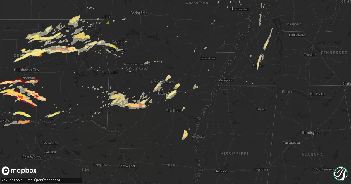
Hail Map in Arkansas on May 30, 2013
Get this storm
May 30 map
$229
one time, instant access
Download today. No call, no setup
Keep the $229
Bought the map and want the full workflow? Apply the entire $229 to a subscription within 7 days. None of it is wasted.
Every map, not just this one
This buys you this map. Subscription and you get every map we run, in the markets you choose from a few cities to whole states to nationwide. Plus real-time alerts the moment a storm fires.
Contact data
Name, contact info, occupancy, even credit band for addresses in the footprint. You go from where it hit to who to call.
Become the source they trust
Unlimited branding weather history reports on demand. You already have the documented answer ready for the property owner, and you are the one who showed up with it.
Property data and RoofTrace estimates
Pull up any address you have got, its value and the exact code rules for that jurisdiction, straight from One Click Code. Then RoofTrace estimates the squares, pitch, and roof value, priced the way you price.
Storm reports in Arkansas
Arkansas
| Date | Description |
|---|---|
| 05/30/20136:10 PM CDT | A local report indicates 1.75 inch wind near COLLINS |
| 05/30/20136:00 PM CDT | One person injured due to a tree blowing down. |
| 05/30/20135:45 PM CDT | Several trees and tree limbs down. A few power poles also down. Damage occurred near the lawrence and sharp county line. |
| 05/30/20134:35 PM CDT | Tornado was reported. |
| 05/30/20134:04 PM CDT | Numerous trees and powerlines were reported to be down. |
| 05/30/20133:57 PM CDT | Damage reported in cove. |
| 05/30/20133:51 PM CDT | Tornado was reported. |
| 05/30/20133:42 PM CDT | Trees reported down over highway 70. |
| 05/30/20133:38 PM CDT | Moving towards lena landing. |
| 05/30/20133:19 PM CDT | *** 3 inj *** damage also was reported north of amity. |
| 05/30/20133:17 PM CDT | Trailer was destroyed and three houses were damanged. Report relayed through klrt. |
| 05/30/20133:03 PM CDT | *** 2 inj *** house was reported to be destroyed in west side of oden. Two reported to be injured. Power lines also down...and highway 88 is blocked. |
| 05/30/20133:00 PM CDT | Numerous trees reported down in and near mountain home. |
| 05/30/20132:03 PM CDT | Numerous trees and power lines were reported down. County road 127 reported to be blocked by trees. |
| 05/30/20136:00 AM CDT | Trees down on highway 163 and power pole down on highway 1 in cherry valley. |
| 05/30/201312:45 AM CDT | House destroyed in brinkley on armstrong lane. Shed destroyed in town. Several trees down on highway 70 just east of town. |
| 05/30/201312:45 AM CDT | Arkansas state police report interstate 40 closed at mile marker 217 for the removal of two tractor trailers that were blown over. |
| 05/30/201312:30 AM CDT | Roof blown off a house near the intersection of highway 302 and gibbs road. |
| 05/30/201312:15 AM CDT | Trees and powers lines were down. A barn was blown into the road near the intersection of highway 38 and 31. |
| 05/29/201311:52 PM CDT | Two empty semi trailer trucks driving on highway 64 two miles east of earle were blown around by wind. One was turned 360 degrees the other was blown off the road. |
| 05/29/201311:00 PM CDT | Trees down |
| 05/29/201310:30 PM CDT | Report from social media |
| 05/29/201310:26 PM CDT | Copious amounts of dime to nickel hail also reported |
| 05/29/201310:00 PM CDT | Also street flooding reported in lonoke. |
| 05/29/20139:50 PM CDT | Tree down and several large limbs down |
| 05/29/20139:31 PM CDT | A local report indicates 60 MPH wind near MACON |
| 05/29/20139:30 PM CDT | Trees were snapped or uprooted. Also 3 inches of rain fell. |
| 05/29/20139:30 PM CDT | Tree fell onto a vehicle with people trapped inside the vehicle. |
| 05/29/20139:30 PM CDT | Numerous trees were blown down on east partridge lane...with some trees on houses. |
| 05/29/20139:17 PM CDT | 8 inch diameter tree was blown down. |
| 05/29/20139:06 PM CDT | Several trees reported to be snapped. Also several trees reported to be blown onto houses. |
| 05/29/20138:57 PM CDT | Hail reported to last for five minutes. |
| 05/29/20138:45 PM CDT | Trees were snapped or uprooted. Lake winona road is blocked by trees and completely impassable. |
| 05/29/20138:15 PM CDT | Trees reported blown down along highway 113. |
| 05/29/20138:00 PM CDT | Reported through the paron fire department. |
| 05/29/20137:50 PM CDT | Chruch was reported to be detroyed in paron. |
| 05/29/20137:50 PM CDT | A local report indicates 1.25 inch wind near 4 SW BONNERDALE |
| 05/29/20137:47 PM CDT | A local report indicates 1.00 inch wind near 1 E GLENWOOD |
| 05/29/20137:35 PM CDT | Numerous trees down in caddo gap. |
All States Impacted by Hail Map on May 30, 2013
Cities Impacted by Hail Map on May 30, 2013
- Leon, OK
- Reedsburg, WI
- La Valle, WI
- Hillpoint, WI
- Lime Ridge, WI
- Cazenovia, WI
- Coleman, MI
- Mount Pleasant, MI
- Midland, MI
- Mountain Lake, MN
- Butterfield, MN
- Shepherd, MI
- Owensboro, KY
- Dyer, IN
- Chicago Heights, IL
- Munster, IN
- Hammond, IN
- Lansing, IL
- Big Cabin, OK
- East Jordan, MI
- Elmira, MI
- Martell, NE
- Hickman, NE
- Roca, NE
- Ellis Grove, IL
- Modoc, IL
- Rogers, AR
- Eureka Springs, AR
- Independence, MO
- Rogers City, MI
- Pontiac, MI
- Troy, MI
- Auburn Hills, MI
- Bloomfield Hills, MI
- Rochester, MI
- Dennard, AR
- Gladwin, MI
- Harrison, MI
- Kansas City, KS
- Basehor, KS
- Mena, AR
- Mount Vernon, AR
- Enola, AR
- Berryton, KS
- Lecompton, KS
- Tecumseh, KS
- Bradley, OK
- Alex, OK
- Lake City, MI
- Millersburg, MI
- Chouteau, OK
- Pryor, OK
- Locust Grove, OK
- Pomona, KS
- Fletcher, OK
- Rose, OK
- Salina, OK
- Anadarko, OK
- Elkins, AR
- Red Rock, OK
- Gentry, AR
- Springdale, AR
- Siloam Springs, AR
- Sulphur, OK
- Stratford, OK
- Maysville, OK
- Roff, OK
- Lindsay, OK
- Davis, OK
- Wynnewood, OK
- Pauls Valley, OK
- Clio, MI
- Millington, MI
- Wann, OK
- Coffeyville, KS
- S Coffeyville, OK
- Lenapah, OK
- Pelahatchie, MS
- Lawrence, KS
- Lyndon, KS
- Osage City, KS
- Quenemo, KS
- Ottawa, KS
- Vassar, KS
- Baldwin City, KS
- Overbrook, KS
- Waverly, NE
- Greenwood, NE
- Davey, NE
- Lincoln, NE
- Dermott, AR
- Gravois Mills, MO
- Hector, AR
- Witts Springs, AR
- Pelsor, AR
- Nocona, TX
- Saint Jo, TX
- Burneyville, OK
- Garber, OK
- Morrison, OK
- Pawhuska, OK
- Fairfax, OK
- Wynona, OK
- Pawnee, OK
- Ponca City, OK
- Billings, OK
- Marland, OK
- Perry, OK
- Hominy, OK
- Ralston, OK
- Higbee, MO
- Continental, OH
- Cloverdale, OH
- Boonville, MO
- Nelson, MO
- Blackwater, MO
- Pilot Grove, MO
- Hughesville, MO
- Gardner, KS
- Spring Hill, KS
- New Century, KS
- Edgerton, KS
- Olathe, KS
- National City, MI
- Tawas City, MI
- Jay, OK
- Colcord, OK
- Topeka, KS
- Lavinia, TN
- Cedar Grove, TN
- Jackson, TN
- Ringgold, TX
- Tulsa, OK
- Broken Arrow, OK
- Henrietta, TX
- Collinsville, OK
- Talala, OK
- Chelsea, OK
- Claremore, OK
- Oologah, OK
- Strang, OK
- Owasso, OK
- Adair, OK
- Vinita, OK
- Hays, KS
- La Porte, IN
- Union Pier, MI
- New Buffalo, MI
- Three Oaks, MI
- Burbank, OK
- Parsons, KS
- McCune, KS
- Mahomet, IL
- Shirley, AR
- Burbank, SD
- Elk Point, SD
- Cashion, OK
- Guthrie, OK
- Kingfisher, OK
- Okarche, OK
- Crescent, OK
- Fremont, WI
- Crete, NE
- Auburn, MI
- Linwood, MI
- Kawkawlin, MI
- Wapello, IA
- Muscatine, IA
- Remus, MI
- Barryton, MI
- Miami, OK
- Kent, IL
- Lena, IL
- Alvo, NE
- Lyndon Station, WI
- Weeping Water, NE
- Plattsmouth, NE
- Murdock, NE
- Louisville, NE
- Fife Lake, MI
- Junction City, KS
- White City, KS
- Chapman, KS
- Hope, KS
- Woodbine, KS
- Alma, KS
- Dwight, KS
- Alta Vista, KS
- Foster, OK
- Marlow, OK
- Rush Springs, OK
- Mount Ida, AR
- Oden, AR
- Hardtner, KS
- Medicine Lodge, KS
- Ashland, KS
- Coldwater, KS
- Lake City, KS
- Protection, KS
- Marshall, IL
- Dennison, IL
- Whitefield, OK
- Cleveland, OK
- Denton, NE
- Ashland, NE
- Ward, AR
- Austin, AR
- Lonoke, AR
- Glenwood, IL
- Tahlequah, OK
- Perkins, OK
- Bismarck, AR
- Malvern, AR
- Hemlock, MI
- Merrill, MI
- Williamsfield, IL
- Pacific Junction, IA
- Raymore, MO
- Paris, TN
- Gleason, TN
- Henry, TN
- McKenzie, TN
- Kenefic, OK
- Durant, OK
- Madill, OK
- Kingston, OK
- Caddo, OK
- Mead, OK
- Saint Louis, MI
- Grantville, KS
- Perryville, MO
- Fayetteville, AR
- Prairie Grove, AR
- Summers, AR
- Lincoln, AR
- Harmon, IL
- Amboy, IL
- Walnut, IL
- Ohio, IL
- Osceola, MO
- Water Valley, MS
- Oxford, MS
- Paris, MS
- Danvers, IL
- Levering, MI
- Cheboygan, MI
- Apple River, IL
- Barnett, MO
- Versailles, MO
- Bartlesville, OK
- Cottage Grove, TN
- Kansas City, MO
- Lees Summit, MO
- Auburn, KS
- Burlingame, KS
- Cement, OK
- Bennet, NE
- Palmyra, NE
- Tonganoxie, KS
- Hallam, NE
- Osborne, KS
- Waldo, KS
- Prescott, MI
- Sterling, MI
- Twining, MI
- Atlanta, MI
- Mayfield, KY
- Wahoo, NE
- Ithaca, NE
- Mead, NE
- Yutan, NE
- Marshall, OK
- Linton, IN
- Beaverton, MI
- Venedocia, OH
- Paoli, OK
- Elmore City, OK
- De Witt, NE
- Stover, MO
- Reynolds, IL
- Milan, IL
- Aledo, IL
- Cuba City, WI
- Sainte Genevieve, MO
- Sparta, IL
- Hawks, MI
- Marion, WI
- Weidman, MI
- Farwell, MI
- Clare, MI
- Lake, MI
- Liberty, KS
- Delaware, OK
- Copan, OK
- Spavinaw, OK
- Eucha, OK
- Caney, OK
- Ringling, OK
- Wilson, OK
- Providence, KY
- Verden, OK
- Whittemore, MI
- Omer, MI
- Treece, KS
- Picher, OK
- Baxter Springs, KS
- Fancy Farm, KY
- Boaz, KY
- West Paducah, KY
- Paducah, KY
- Melber, KY
- Metropolis, IL
- Hickory, KY
- Lexington, OK
- Noble, OK
- Washington, OK
- Wanette, OK
- Macomb, OK
- Purcell, OK
- Hot Springs National Park, AR
- Pearcy, AR
- Royal, AR
- Sabula, IA
- Wolverine, MI
- Sebewaing, MI
- Bay Port, MI
- Randolph, WI
- Fall River, WI
- Avoca, NE
- Maple Hill, KS
- Bonner Springs, KS
- Riverside, MO
- Liberty, MO
- Excelsior Springs, MO
- Orrick, MO
- Missouri City, MO
- Delphos, OH
- Fort Jennings, OH
- Ottoville, OH
- Blair, NE
- Ryan, OK
- Mount Carroll, IL
- Savanna, IL
- Sapulpa, OK
- Mannford, OK
- Jennings, OK
- Sand Springs, OK
- Cushing, OK
- Drumright, OK
- Bristow, OK
- Pickrell, NE
- Dolton, IL
- Calumet City, IL
- Chicago, IL
- South Holland, IL
- Stuttgart, AR
- Altheimer, AR
- Norman, AR
- Lonsdale, AR
- Apache, OK
- Elgin, OK
- Belleville, IL
- Cape Girardeau, MO
- Saint Charles, MI
- Saginaw, MI
- Medina, TN
- Milan, TN
- Oakfield, TN
- Medon, TN
- Princeton, KS
- Olney, IL
- Lewis, IA
- Belton, MO
- Stilwell, KS
- Grandview, MO
- Sperry, OK
- Prue, OK
- Osage, OK
- Skiatook, OK
- Williamsburg, KS
- Duncan, OK
- Ninnekah, OK
- Tussy, OK
- Lawton, OK
- Hennepin, OK
- Springer, OK
- Brinkley, AR
- Warrensburg, MO
- Toulon, IL
- Hensley, AR
- Rantoul, KS
- Coyle, OK
- Columbus, WI
- Rio, WI
- Sun Prairie, WI
- Madison, WI
- Deforest, WI
- Windsor, WI
- Vergennes, IL
- Murphysboro, IL
- Paron, AR
- Watts, OK
- Pierce City, MO
- Brant, MI
- Chesaning, MI
- Oakley, MI
- Merrillville, IN
- Crown Point, IN
- Hamburg, AR
- Montrose, AR
- Atwood, TN
- Assaria, KS
- Gypsum, KS
- Mancelona, MI
- Kuttawa, KY
- Eddyville, KY
- Fredonia, KY
- Princeton, KY
- Little Rock, AR
- Scott, AR
- North Little Rock, AR
- Red Oak, OK
- Wister, OK
- Vilonia, AR
- Council Grove, KS
- Beebe, AR
- Carlisle, AR
- Chickasha, OK
- Amber, OK
- Barnsdall, OK
- Newaygo, MI
- Grant, MI
- Fullerton, NE
- Conway, AR
- Mayflower, AR
- Bigelow, AR
- Roland, AR
- Mulhall, OK
- Hodgen, OK
- Poplar Bluff, MO
- Peace Valley, MO
- Paxico, KS
- Eskridge, KS
- Allen, KS
- Wellsville, KS
- Saulsbury, TN
- Atoka, OK
- Minier, IL
- Marshall, WI
- Grayling, MI
- Hoisington, KS
- Gaylord, MI
- Dewey, OK
- Independence, KS
- Caney, KS
- Dearing, KS
- Bentley, MI
- Standish, MI
- Alger, MI
- Wellston, OK
- Stillwater, OK
- Yale, OK
- Ripley, OK
- Tryon, OK
- Brownell, KS
- Caddo Gap, AR
- Pinconning, MI
- Hartman, AR
- Zalma, MO
- Overbrook, OK
- Waurika, OK
- Waverly, KS
- Melvern, KS
- Catoosa, OK
- Bixby, OK
- Jenks, OK
- Canton, SD
- Harrisburg, SD
- Hazleton, IN
- Patoka, IN
- Coweta, OK
- Porter, OK
- Fort Calhoun, NE
- Omaha, NE
- Granby, MO
- Bentonville, AR
- Ava, IL
- Brandon, WI
- Rosendale, WI
- Odell, IL
- Bluejacket, OK
- Wakarusa, KS
- Cerulean, KY
- Clinton, AR
- Sedalia, MO
- Houstonia, MO
- Marshall, MO
- Ness City, KS
- Nickerson, NE
- West Liberty, IL
- Delta, OH
- Greensburg, IN
- Windom, MN
- Monee, IL
- University Park, IL
- Riverdale, IL
- Park Forest, IL
- Gary, IN
- Grant Park, IL
- Peotone, IL
- Steger, IL
- Highland, IN
- Thornton, IL
- Crete, IL
- Whiting, IN
- Schererville, IN
- Beecher, IL
- East Chicago, IN
- Manteno, IL
- Broken Bow, OK
- Harveyville, KS
- Sallisaw, OK
- Salem, AR
- Kalkaska, MI
- Frederic, MI
- Elwell, MI
- Alma, MI
- Neponset, IL
- La Fayette, IL
- Davenport, IA
- Coal Valley, IL
- Moline, IL
- Bettendorf, IA
- Eldridge, IA
- Rock Island, IL
- Vermillion, SD
- Dexter, KY
- Murray, KY
- Hazel, KY
- Almo, KY
- Puryear, TN
- Verona, WI
- Belleville, WI
- Oregon, WI
- Glenwood, IA
- Manley, NE
- West Fork, AR
- McGehee, AR
- Greenville, MS
- Platteville, WI
- Sheridan, AR
- Benton, AR
- Donaldson, AR
- Blanchard, OK
- Bingham Lake, MN
- Fort Cobb, OK
- Van Wert, OH
- Hulbert, OK
- Overland Park, KS
- Paola, KS
- Peculiar, MO
- Harrisonville, MO
- Pleasant Hill, MO
- Greenwood, MO
- Tekamah, NE
- Rhodes, MI
- Romance, AR
- Greenbrier, AR
- Concordia, MO
- Bonnerdale, AR
- Glenwood, AR
- Amity, AR
- Monett, MO
- Verona, MO
- Iron Ridge, WI
- Horicon, WI
- Maramec, OK
- Glencoe, OK
- Shidler, OK
- Proctor, OK
- Dewitt, MI
- Lincolnville, KS
- Herington, KS
- Wilsey, KS
- Burdick, KS
- Lost Springs, KS
- Delaplaine, AR
- Walnut Ridge, AR
- Beech Grove, AR
- Elkton, MI
- Bad Axe, MI
- Melvin, IA
- Sanborn, IA
- Honobia, OK
- Hennessey, OK
- Morton, MS
- Lena, MS
- Wilburton, OK
- Ransom, KS
- Meriden, KS
- Ozawkie, KS
- Washington, MI
- Ray, MI
- Oak Ridge, MO
- Friedheim, MO
- Daisy, MO
- Downers Grove, IL
- Pigeon, MI
- Odessa, MO
- Smithville, OK
- Humboldt, TN
- Trenton, TN
- Waldron, AR
- Wolf Lake, IL
- Jackson, MO
- Concord, NE
- Dixon, NE
- Gresham, WI
- Shawano, WI
- Keshena, WI
- Coleman, OK
- Perry, KS
- Sioux City, IA
- Sergeant Bluff, IA
- Lawton, IA
- Kingsley, IA
- Moville, IA
- Abilene, KS
- Beloit, KS
- Boles, AR
- Vandervoort, AR
- Cove, AR
- New Haven, MI
- Waupun, WI
- Markesan, WI
- Parks, AR
- Bucyrus, KS
- Olivet, MI
- Watson, OK
- Manton, MI
- Kennard, NE
- Ramona, OK
- Ochelata, OK
- Dixon, KY
- Sterling Heights, MI
- Unionville, MI
- Fredericktown, MO
- La Monte, MO
- Sweet Springs, MO
- Cotton Plant, AR
- Wheatley, AR
- Wickes, AR
- Emporia, KS
- Admire, KS
- Reading, KS
- Cross Timbers, MO
- Macks Creek, MO
- Climax Springs, MO
- Tunas, MO
- Roach, MO
- Edwards, MO
- Red Bud, IL
- Camp, AR
- Charlotte, MI
- Coffeeville, MS
- Chilhowee, MO
- Leeton, MO
- Harrisburg, AR
- Cherry Valley, AR
- Nowata, OK
- Prairie Du Rocher, IL
- Scranton, KS
- Franklin, MI
- Carbondale, KS
- Wheeler, MI
- Old Monroe, MO
- Winfield, MO
- O'Fallon, MO
- Sheffield, IL
- Princeton, IL
- Wyanet, IL
- Pierson, IA
- Mount Morris, MI
- Saint Mary, MO
- Booneville, AR
- Mansfield, AR
- Armington, IL
- Stanford, IL
- Atlanta, IL
- Delavan, IL
- Emden, IL
- Hartsburg, IL
- Calhoun, KY
- Rumsey, KY
- Magnolia, MN
- Spencerville, IN
- Hicksville, OH
- Burfordville, MO
- Whitewater, MO
- Lakefield, MN
- Tipton, MO
- Fortuna, MO
- Latham, MO
- Ellis, KS
- Mauston, WI
- Loganville, WI
- Johannesburg, MI
- Mascoutah, IL
- Champaign, IL
- Roberts, IL
- Saint Anne, IL
- Streator, IL
- Ransom, IL
- Grand Ridge, IL
- Seneca, IL
- Marseilles, IL
- Jacksonville, AR
- Le Mars, IA
- Remsen, IA
- Deerfield, WI
- Waterloo, WI
- Bluffs, IL
- Winchester, IL
- Alcester, SD
- Belleville, MI
- New Boston, MI
- Millstadt, IL
- Smithton, IL
- Hot Springs Village, AR
- Collins, MO
- Bazine, KS
- Baldwin, IL
- Palmyra, IL
- Carlinville, IL
- Alexander, KS
- Welch, OK
- Coatesville, IN
- Holgate, OH
- Golconda, IL
- Madison, VA
- Alexandria, MO
- Ashton, IA
- Freeburg, IL
- Waterloo, IL
- Galena, IL
- Eldon, MO
- Olean, MO
- Howe, OK
- Fox Lake, WI
- Ozark, AR
- Potterville, MI
- Jessieville, AR
- Hatfield, AR
- Langley, AR
- Umpire, AR
- Valliant, OK
- Raymond, NE
- Winslow, AR
- Wapanucka, OK
- Grove, OK
- Gore, OK
- Vian, OK
- Terlton, OK
- Oskaloosa, KS
- McFarland, KS
- Enterprise, KS
- Kingsville, MO
- Bates City, MO
- Holden, MO
- England, AR
- Hartley, IA
- Ocheyedan, IA
- Lakeside, MI
- Harbert, MI
- Cabot, AR
- Lincoln, IL
- El Paso, IL
- Leslie, AR
- Paradise, KS
- Brandon, MS
- Princeton, IA
- Long Grove, IA
- Prudenville, MI
- Houghton Lake, MI
- Eldorado, IL
- Springville, TN
- Portage, IN
- Roscommon, MI
- Decatur, IN
- Ossian, IN
- Loogootee, IN
- Marble Hill, MO
- White Cloud, MI
- Frohna, MO
- Pearl City, IL
- Stockton, IL
- Centerview, MO
- Evansville, IL
- Hazen, AR
- De Valls Bluff, AR
- Carnegie, OK
- Heavener, OK
- Webbers Falls, OK
- Wagoner, OK
- Moyers, OK
- Antlers, OK
- Wooldridge, MO
- Columbus, KS
- Grand Junction, TN
- Somerville, TN
- Carson, IA
- Macedonia, IA
- Montpelier, IN
- Hartford City, IN
- Rocky Mount, MO
- Genoa, NE
- Janesville, WI
- West Point, IA
- Donnellson, IA
- Fort Madison, IA
- Byars, OK
- Ada, OK
- Temple, OK
- Middle Point, OH
- Downs, KS
- Fults, IL
- New Athens, IL
- Boyne Falls, MI
- Tuckerman, AR
- Paxton, IL
- Dewey, IL
- Sibley, MO
- Richmond, MO
- Buckner, MO
- Kankakee, IL
- Marion, KS
- Ramona, KS
- Sanford, MI
- Wayne, NE
- Malcolm, NE
- Gretna, NE
- Silver City, IA
- Maumelle, AR
- Southgate, MI
- Riverview, MI
- Wyandotte, MI
- Hillman, MI
- Corunna, MI
- Owosso, MI
- Maysville, AR
- Decatur, AR
- Hindsville, AR
- Peggs, OK
- Inola, OK
- Kansas, OK
- Fairgrove, MI
- Cadiz, KY
- Gracey, KY
- Eldorado, WI
- Eufaula, OK
- Ithaca, MI
- Williamsville, MO
- Cole Camp, MO
- Wilber, NE
- Marshall, MI
- Carthage, MS
- Chesterton, IN
- Valparaiso, IN
- Flint, MI
- Hillsdale, IN
- Clinton, IN
- Dana, IN
- Charlevoix, MI
- Simpson, IL
- Pellston, MI
- Brutus, MI
- Sadorus, IL
- Ivesdale, IL
- Mora, MO
- Lake Station, IN
- Gravelly, AR
- Bluffton, AR
- Broughton, IL
- Aurora, MO
- Walsh, IL
- Blairstown, MO
- Stockton, MO
- Humansville, MO
- Freeland, MI
- Secor, IL
- Minonk, IL
- Carlock, IL
- Cortland, NE
- Dora, MO
- Cannelburg, IN
- Black Rock, AR
- Smithville, AR
- Powhatan, AR
- Saint Johns, MI
- Ashley, MI
- Elsie, MI
- Bannister, MI
- Clinton, IA
- Williamstown, MO
- Canton, MO
- Mountain Pine, AR
- Silver Lake, KS
- Delia, KS
- Henderson, MI
- Natoma, KS
- Hinton, IA
- Wichita Falls, TX
- Mountain View, OK
- Camanche, IA
- Pleasant Dale, NE
- Westville, OK
- Agra, OK
- Crescent, IA
- Missouri Valley, IA
- Honey Creek, IA
- Nebraska City, NE
- Sidney, IA
- Hamburg, IA
- Ratliff City, OK
- Pocasset, OK
- Gracemont, OK
- Norman, OK
- Tuttle, OK
- Cyril, OK
- Pontiac, IL
- Cornell, IL
- Chenoa, IL
- Dixon, IL
- De Witt, IA
- Boyne City, MI
- Mecosta, MI
- Neosho, MO


