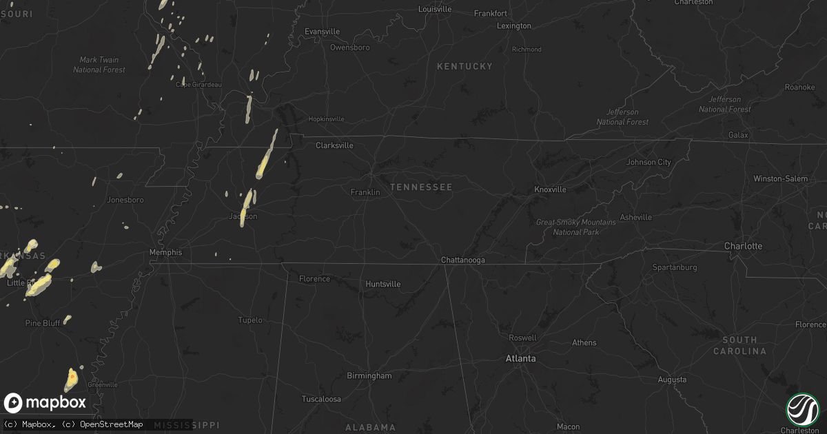
Hail Map in Tennessee on May 30, 2013
Get this storm
May 30 map
$229
one time, instant access
Download today. No call, no setup
Keep the $229
Bought the map and want the full workflow? Apply the entire $229 to a subscription within 7 days. None of it is wasted.
Every map, not just this one
This buys you this map. Subscription and you get every map we run, in the markets you choose from a few cities to whole states to nationwide. Plus real-time alerts the moment a storm fires.
Contact data
Name, contact info, occupancy, even credit band for addresses in the footprint. You go from where it hit to who to call.
Become the source they trust
Unlimited branding weather history reports on demand. You already have the documented answer ready for the property owner, and you are the one who showed up with it.
Property data and RoofTrace estimates
Pull up any address you have got, its value and the exact code rules for that jurisdiction, straight from One Click Code. Then RoofTrace estimates the squares, pitch, and roof value, priced the way you price.
Storm reports in Tennessee
Tennessee
| Date | Description |
|---|---|
| 05/30/20136:50 PM CDT | Trees down across the city...dime size hail...power outages |
| 05/30/20136:45 PM CDT | Large tree down across highway 18...both lanes of traffic blocked...power lines also down. |
| 05/30/20136:18 PM CDT | Winds in excess of 60 mph... Penny size hail |
| 05/30/20136:15 PM CDT | Penny size hail also reported. |
| 05/30/20134:15 PM CDT | Large tree limbs down...north end of county just off natchez trace road...estimated 35-40 mph wind...pea size hail...minor street flooding |
| 05/30/20136:05 AM CDT | Strong winds destroyed two homes on mount lebanon road. Several other homes had roof and some structural damage.winds moved cars and trucks a significant amount.all the |
| 05/30/20136:05 AM CDT | Strong winds destroyed two homes on mount lebanon road. Several other homes had roof and some structural damage.winds moved cars and trucks a significant amount.all the |
| 05/29/20138:00 PM CDT | Relayed from public to nws employee at the paducah wfo. |
| 05/29/20138:00 PM CDT | Numerous trees and power lines down across town. One tree fell on a car with possible injuries. Relayed from public to nws employee at the paducah wfo. |
| 05/29/20137:45 PM CDT | Small tree limbs down. |
| 05/29/20137:25 PM CDT | Trees down on stinson road. |
| 05/29/20137:15 PM CDT | Quarter size hail...trees uprooted by the wind |
| 05/29/20137:15 PM CDT | Winds in excess of 60 mph...tree limbs down... Pea size hail |
| 05/29/20137:00 PM CDT | Quarter size hail...trees down |
| 05/29/20137:00 PM CDT | 65-70 mph estimated... Trees down... Power outages |
| 05/29/20137:00 PM CDT | Twisted trees...a barn completely destroyed. |
All States Impacted by Hail Map on May 30, 2013
Cities Impacted by Hail Map on May 30, 2013
- Leon, OK
- Reedsburg, WI
- La Valle, WI
- Hillpoint, WI
- Lime Ridge, WI
- Cazenovia, WI
- Coleman, MI
- Mount Pleasant, MI
- Midland, MI
- Mountain Lake, MN
- Butterfield, MN
- Shepherd, MI
- Owensboro, KY
- Dyer, IN
- Chicago Heights, IL
- Munster, IN
- Hammond, IN
- Lansing, IL
- Big Cabin, OK
- East Jordan, MI
- Elmira, MI
- Martell, NE
- Hickman, NE
- Roca, NE
- Ellis Grove, IL
- Modoc, IL
- Rogers, AR
- Eureka Springs, AR
- Independence, MO
- Rogers City, MI
- Pontiac, MI
- Troy, MI
- Auburn Hills, MI
- Bloomfield Hills, MI
- Rochester, MI
- Dennard, AR
- Gladwin, MI
- Harrison, MI
- Kansas City, KS
- Basehor, KS
- Mena, AR
- Mount Vernon, AR
- Enola, AR
- Berryton, KS
- Lecompton, KS
- Tecumseh, KS
- Bradley, OK
- Alex, OK
- Lake City, MI
- Millersburg, MI
- Chouteau, OK
- Pryor, OK
- Locust Grove, OK
- Pomona, KS
- Fletcher, OK
- Rose, OK
- Salina, OK
- Anadarko, OK
- Elkins, AR
- Red Rock, OK
- Gentry, AR
- Springdale, AR
- Siloam Springs, AR
- Sulphur, OK
- Stratford, OK
- Maysville, OK
- Roff, OK
- Lindsay, OK
- Davis, OK
- Wynnewood, OK
- Pauls Valley, OK
- Clio, MI
- Millington, MI
- Wann, OK
- Coffeyville, KS
- S Coffeyville, OK
- Lenapah, OK
- Pelahatchie, MS
- Lawrence, KS
- Lyndon, KS
- Osage City, KS
- Quenemo, KS
- Ottawa, KS
- Vassar, KS
- Baldwin City, KS
- Overbrook, KS
- Waverly, NE
- Greenwood, NE
- Davey, NE
- Lincoln, NE
- Dermott, AR
- Gravois Mills, MO
- Hector, AR
- Witts Springs, AR
- Pelsor, AR
- Nocona, TX
- Saint Jo, TX
- Burneyville, OK
- Garber, OK
- Morrison, OK
- Pawhuska, OK
- Fairfax, OK
- Wynona, OK
- Pawnee, OK
- Ponca City, OK
- Billings, OK
- Marland, OK
- Perry, OK
- Hominy, OK
- Ralston, OK
- Higbee, MO
- Continental, OH
- Cloverdale, OH
- Boonville, MO
- Nelson, MO
- Blackwater, MO
- Pilot Grove, MO
- Hughesville, MO
- Gardner, KS
- Spring Hill, KS
- New Century, KS
- Edgerton, KS
- Olathe, KS
- National City, MI
- Tawas City, MI
- Jay, OK
- Colcord, OK
- Topeka, KS
- Lavinia, TN
- Cedar Grove, TN
- Jackson, TN
- Ringgold, TX
- Tulsa, OK
- Broken Arrow, OK
- Henrietta, TX
- Collinsville, OK
- Talala, OK
- Chelsea, OK
- Claremore, OK
- Oologah, OK
- Strang, OK
- Owasso, OK
- Adair, OK
- Vinita, OK
- Hays, KS
- La Porte, IN
- Union Pier, MI
- New Buffalo, MI
- Three Oaks, MI
- Burbank, OK
- Parsons, KS
- McCune, KS
- Mahomet, IL
- Shirley, AR
- Burbank, SD
- Elk Point, SD
- Cashion, OK
- Guthrie, OK
- Kingfisher, OK
- Okarche, OK
- Crescent, OK
- Fremont, WI
- Crete, NE
- Auburn, MI
- Linwood, MI
- Kawkawlin, MI
- Wapello, IA
- Muscatine, IA
- Remus, MI
- Barryton, MI
- Miami, OK
- Kent, IL
- Lena, IL
- Alvo, NE
- Lyndon Station, WI
- Weeping Water, NE
- Plattsmouth, NE
- Murdock, NE
- Louisville, NE
- Fife Lake, MI
- Junction City, KS
- White City, KS
- Chapman, KS
- Hope, KS
- Woodbine, KS
- Alma, KS
- Dwight, KS
- Alta Vista, KS
- Foster, OK
- Marlow, OK
- Rush Springs, OK
- Mount Ida, AR
- Oden, AR
- Hardtner, KS
- Medicine Lodge, KS
- Ashland, KS
- Coldwater, KS
- Lake City, KS
- Protection, KS
- Marshall, IL
- Dennison, IL
- Whitefield, OK
- Cleveland, OK
- Denton, NE
- Ashland, NE
- Ward, AR
- Austin, AR
- Lonoke, AR
- Glenwood, IL
- Tahlequah, OK
- Perkins, OK
- Bismarck, AR
- Malvern, AR
- Hemlock, MI
- Merrill, MI
- Williamsfield, IL
- Pacific Junction, IA
- Raymore, MO
- Paris, TN
- Gleason, TN
- Henry, TN
- McKenzie, TN
- Kenefic, OK
- Durant, OK
- Madill, OK
- Kingston, OK
- Caddo, OK
- Mead, OK
- Saint Louis, MI
- Grantville, KS
- Perryville, MO
- Fayetteville, AR
- Prairie Grove, AR
- Summers, AR
- Lincoln, AR
- Harmon, IL
- Amboy, IL
- Walnut, IL
- Ohio, IL
- Osceola, MO
- Water Valley, MS
- Oxford, MS
- Paris, MS
- Danvers, IL
- Levering, MI
- Cheboygan, MI
- Apple River, IL
- Barnett, MO
- Versailles, MO
- Bartlesville, OK
- Cottage Grove, TN
- Kansas City, MO
- Lees Summit, MO
- Auburn, KS
- Burlingame, KS
- Cement, OK
- Bennet, NE
- Palmyra, NE
- Tonganoxie, KS
- Hallam, NE
- Osborne, KS
- Waldo, KS
- Prescott, MI
- Sterling, MI
- Twining, MI
- Atlanta, MI
- Mayfield, KY
- Wahoo, NE
- Ithaca, NE
- Mead, NE
- Yutan, NE
- Marshall, OK
- Linton, IN
- Beaverton, MI
- Venedocia, OH
- Paoli, OK
- Elmore City, OK
- De Witt, NE
- Stover, MO
- Reynolds, IL
- Milan, IL
- Aledo, IL
- Cuba City, WI
- Sainte Genevieve, MO
- Sparta, IL
- Hawks, MI
- Marion, WI
- Weidman, MI
- Farwell, MI
- Clare, MI
- Lake, MI
- Liberty, KS
- Delaware, OK
- Copan, OK
- Spavinaw, OK
- Eucha, OK
- Caney, OK
- Ringling, OK
- Wilson, OK
- Providence, KY
- Verden, OK
- Whittemore, MI
- Omer, MI
- Treece, KS
- Picher, OK
- Baxter Springs, KS
- Fancy Farm, KY
- Boaz, KY
- West Paducah, KY
- Paducah, KY
- Melber, KY
- Metropolis, IL
- Hickory, KY
- Lexington, OK
- Noble, OK
- Washington, OK
- Wanette, OK
- Macomb, OK
- Purcell, OK
- Hot Springs National Park, AR
- Pearcy, AR
- Royal, AR
- Sabula, IA
- Wolverine, MI
- Sebewaing, MI
- Bay Port, MI
- Randolph, WI
- Fall River, WI
- Avoca, NE
- Maple Hill, KS
- Bonner Springs, KS
- Riverside, MO
- Liberty, MO
- Excelsior Springs, MO
- Orrick, MO
- Missouri City, MO
- Delphos, OH
- Fort Jennings, OH
- Ottoville, OH
- Blair, NE
- Ryan, OK
- Mount Carroll, IL
- Savanna, IL
- Sapulpa, OK
- Mannford, OK
- Jennings, OK
- Sand Springs, OK
- Cushing, OK
- Drumright, OK
- Bristow, OK
- Pickrell, NE
- Dolton, IL
- Calumet City, IL
- Chicago, IL
- South Holland, IL
- Stuttgart, AR
- Altheimer, AR
- Norman, AR
- Lonsdale, AR
- Apache, OK
- Elgin, OK
- Belleville, IL
- Cape Girardeau, MO
- Saint Charles, MI
- Saginaw, MI
- Medina, TN
- Milan, TN
- Oakfield, TN
- Medon, TN
- Princeton, KS
- Olney, IL
- Lewis, IA
- Belton, MO
- Stilwell, KS
- Grandview, MO
- Sperry, OK
- Prue, OK
- Osage, OK
- Skiatook, OK
- Williamsburg, KS
- Duncan, OK
- Ninnekah, OK
- Tussy, OK
- Lawton, OK
- Hennepin, OK
- Springer, OK
- Brinkley, AR
- Warrensburg, MO
- Toulon, IL
- Hensley, AR
- Rantoul, KS
- Coyle, OK
- Columbus, WI
- Rio, WI
- Sun Prairie, WI
- Madison, WI
- Deforest, WI
- Windsor, WI
- Vergennes, IL
- Murphysboro, IL
- Paron, AR
- Watts, OK
- Pierce City, MO
- Brant, MI
- Chesaning, MI
- Oakley, MI
- Merrillville, IN
- Crown Point, IN
- Hamburg, AR
- Montrose, AR
- Atwood, TN
- Assaria, KS
- Gypsum, KS
- Mancelona, MI
- Kuttawa, KY
- Eddyville, KY
- Fredonia, KY
- Princeton, KY
- Little Rock, AR
- Scott, AR
- North Little Rock, AR
- Red Oak, OK
- Wister, OK
- Vilonia, AR
- Council Grove, KS
- Beebe, AR
- Carlisle, AR
- Chickasha, OK
- Amber, OK
- Barnsdall, OK
- Newaygo, MI
- Grant, MI
- Fullerton, NE
- Conway, AR
- Mayflower, AR
- Bigelow, AR
- Roland, AR
- Mulhall, OK
- Hodgen, OK
- Poplar Bluff, MO
- Peace Valley, MO
- Paxico, KS
- Eskridge, KS
- Allen, KS
- Wellsville, KS
- Saulsbury, TN
- Atoka, OK
- Minier, IL
- Marshall, WI
- Grayling, MI
- Hoisington, KS
- Gaylord, MI
- Dewey, OK
- Independence, KS
- Caney, KS
- Dearing, KS
- Bentley, MI
- Standish, MI
- Alger, MI
- Wellston, OK
- Stillwater, OK
- Yale, OK
- Ripley, OK
- Tryon, OK
- Brownell, KS
- Caddo Gap, AR
- Pinconning, MI
- Hartman, AR
- Zalma, MO
- Overbrook, OK
- Waurika, OK
- Waverly, KS
- Melvern, KS
- Catoosa, OK
- Bixby, OK
- Jenks, OK
- Canton, SD
- Harrisburg, SD
- Hazleton, IN
- Patoka, IN
- Coweta, OK
- Porter, OK
- Fort Calhoun, NE
- Omaha, NE
- Granby, MO
- Bentonville, AR
- Ava, IL
- Brandon, WI
- Rosendale, WI
- Odell, IL
- Bluejacket, OK
- Wakarusa, KS
- Cerulean, KY
- Clinton, AR
- Sedalia, MO
- Houstonia, MO
- Marshall, MO
- Ness City, KS
- Nickerson, NE
- West Liberty, IL
- Delta, OH
- Greensburg, IN
- Windom, MN
- Monee, IL
- University Park, IL
- Riverdale, IL
- Park Forest, IL
- Gary, IN
- Grant Park, IL
- Peotone, IL
- Steger, IL
- Highland, IN
- Thornton, IL
- Crete, IL
- Whiting, IN
- Schererville, IN
- Beecher, IL
- East Chicago, IN
- Manteno, IL
- Broken Bow, OK
- Harveyville, KS
- Sallisaw, OK
- Salem, AR
- Kalkaska, MI
- Frederic, MI
- Elwell, MI
- Alma, MI
- Neponset, IL
- La Fayette, IL
- Davenport, IA
- Coal Valley, IL
- Moline, IL
- Bettendorf, IA
- Eldridge, IA
- Rock Island, IL
- Vermillion, SD
- Dexter, KY
- Murray, KY
- Hazel, KY
- Almo, KY
- Puryear, TN
- Verona, WI
- Belleville, WI
- Oregon, WI
- Glenwood, IA
- Manley, NE
- West Fork, AR
- McGehee, AR
- Greenville, MS
- Platteville, WI
- Sheridan, AR
- Benton, AR
- Donaldson, AR
- Blanchard, OK
- Bingham Lake, MN
- Fort Cobb, OK
- Van Wert, OH
- Hulbert, OK
- Overland Park, KS
- Paola, KS
- Peculiar, MO
- Harrisonville, MO
- Pleasant Hill, MO
- Greenwood, MO
- Tekamah, NE
- Rhodes, MI
- Romance, AR
- Greenbrier, AR
- Concordia, MO
- Bonnerdale, AR
- Glenwood, AR
- Amity, AR
- Monett, MO
- Verona, MO
- Iron Ridge, WI
- Horicon, WI
- Maramec, OK
- Glencoe, OK
- Shidler, OK
- Proctor, OK
- Dewitt, MI
- Lincolnville, KS
- Herington, KS
- Wilsey, KS
- Burdick, KS
- Lost Springs, KS
- Delaplaine, AR
- Walnut Ridge, AR
- Beech Grove, AR
- Elkton, MI
- Bad Axe, MI
- Melvin, IA
- Sanborn, IA
- Honobia, OK
- Hennessey, OK
- Morton, MS
- Lena, MS
- Wilburton, OK
- Ransom, KS
- Meriden, KS
- Ozawkie, KS
- Washington, MI
- Ray, MI
- Oak Ridge, MO
- Friedheim, MO
- Daisy, MO
- Downers Grove, IL
- Pigeon, MI
- Odessa, MO
- Smithville, OK
- Humboldt, TN
- Trenton, TN
- Waldron, AR
- Wolf Lake, IL
- Jackson, MO
- Concord, NE
- Dixon, NE
- Gresham, WI
- Shawano, WI
- Keshena, WI
- Coleman, OK
- Perry, KS
- Sioux City, IA
- Sergeant Bluff, IA
- Lawton, IA
- Kingsley, IA
- Moville, IA
- Abilene, KS
- Beloit, KS
- Boles, AR
- Vandervoort, AR
- Cove, AR
- New Haven, MI
- Waupun, WI
- Markesan, WI
- Parks, AR
- Bucyrus, KS
- Olivet, MI
- Watson, OK
- Manton, MI
- Kennard, NE
- Ramona, OK
- Ochelata, OK
- Dixon, KY
- Sterling Heights, MI
- Unionville, MI
- Fredericktown, MO
- La Monte, MO
- Sweet Springs, MO
- Cotton Plant, AR
- Wheatley, AR
- Wickes, AR
- Emporia, KS
- Admire, KS
- Reading, KS
- Cross Timbers, MO
- Macks Creek, MO
- Climax Springs, MO
- Tunas, MO
- Roach, MO
- Edwards, MO
- Red Bud, IL
- Camp, AR
- Charlotte, MI
- Coffeeville, MS
- Chilhowee, MO
- Leeton, MO
- Harrisburg, AR
- Cherry Valley, AR
- Nowata, OK
- Prairie Du Rocher, IL
- Scranton, KS
- Franklin, MI
- Carbondale, KS
- Wheeler, MI
- Old Monroe, MO
- Winfield, MO
- O'Fallon, MO
- Sheffield, IL
- Princeton, IL
- Wyanet, IL
- Pierson, IA
- Mount Morris, MI
- Saint Mary, MO
- Booneville, AR
- Mansfield, AR
- Armington, IL
- Stanford, IL
- Atlanta, IL
- Delavan, IL
- Emden, IL
- Hartsburg, IL
- Calhoun, KY
- Rumsey, KY
- Magnolia, MN
- Spencerville, IN
- Hicksville, OH
- Burfordville, MO
- Whitewater, MO
- Lakefield, MN
- Tipton, MO
- Fortuna, MO
- Latham, MO
- Ellis, KS
- Mauston, WI
- Loganville, WI
- Johannesburg, MI
- Mascoutah, IL
- Champaign, IL
- Roberts, IL
- Saint Anne, IL
- Streator, IL
- Ransom, IL
- Grand Ridge, IL
- Seneca, IL
- Marseilles, IL
- Jacksonville, AR
- Le Mars, IA
- Remsen, IA
- Deerfield, WI
- Waterloo, WI
- Bluffs, IL
- Winchester, IL
- Alcester, SD
- Belleville, MI
- New Boston, MI
- Millstadt, IL
- Smithton, IL
- Hot Springs Village, AR
- Collins, MO
- Bazine, KS
- Baldwin, IL
- Palmyra, IL
- Carlinville, IL
- Alexander, KS
- Welch, OK
- Coatesville, IN
- Holgate, OH
- Golconda, IL
- Madison, VA
- Alexandria, MO
- Ashton, IA
- Freeburg, IL
- Waterloo, IL
- Galena, IL
- Eldon, MO
- Olean, MO
- Howe, OK
- Fox Lake, WI
- Ozark, AR
- Potterville, MI
- Jessieville, AR
- Hatfield, AR
- Langley, AR
- Umpire, AR
- Valliant, OK
- Raymond, NE
- Winslow, AR
- Wapanucka, OK
- Grove, OK
- Gore, OK
- Vian, OK
- Terlton, OK
- Oskaloosa, KS
- McFarland, KS
- Enterprise, KS
- Kingsville, MO
- Bates City, MO
- Holden, MO
- England, AR
- Hartley, IA
- Ocheyedan, IA
- Lakeside, MI
- Harbert, MI
- Cabot, AR
- Lincoln, IL
- El Paso, IL
- Leslie, AR
- Paradise, KS
- Brandon, MS
- Princeton, IA
- Long Grove, IA
- Prudenville, MI
- Houghton Lake, MI
- Eldorado, IL
- Springville, TN
- Portage, IN
- Roscommon, MI
- Decatur, IN
- Ossian, IN
- Loogootee, IN
- Marble Hill, MO
- White Cloud, MI
- Frohna, MO
- Pearl City, IL
- Stockton, IL
- Centerview, MO
- Evansville, IL
- Hazen, AR
- De Valls Bluff, AR
- Carnegie, OK
- Heavener, OK
- Webbers Falls, OK
- Wagoner, OK
- Moyers, OK
- Antlers, OK
- Wooldridge, MO
- Columbus, KS
- Grand Junction, TN
- Somerville, TN
- Carson, IA
- Macedonia, IA
- Montpelier, IN
- Hartford City, IN
- Rocky Mount, MO
- Genoa, NE
- Janesville, WI
- West Point, IA
- Donnellson, IA
- Fort Madison, IA
- Byars, OK
- Ada, OK
- Temple, OK
- Middle Point, OH
- Downs, KS
- Fults, IL
- New Athens, IL
- Boyne Falls, MI
- Tuckerman, AR
- Paxton, IL
- Dewey, IL
- Sibley, MO
- Richmond, MO
- Buckner, MO
- Kankakee, IL
- Marion, KS
- Ramona, KS
- Sanford, MI
- Wayne, NE
- Malcolm, NE
- Gretna, NE
- Silver City, IA
- Maumelle, AR
- Southgate, MI
- Riverview, MI
- Wyandotte, MI
- Hillman, MI
- Corunna, MI
- Owosso, MI
- Maysville, AR
- Decatur, AR
- Hindsville, AR
- Peggs, OK
- Inola, OK
- Kansas, OK
- Fairgrove, MI
- Cadiz, KY
- Gracey, KY
- Eldorado, WI
- Eufaula, OK
- Ithaca, MI
- Williamsville, MO
- Cole Camp, MO
- Wilber, NE
- Marshall, MI
- Carthage, MS
- Chesterton, IN
- Valparaiso, IN
- Flint, MI
- Hillsdale, IN
- Clinton, IN
- Dana, IN
- Charlevoix, MI
- Simpson, IL
- Pellston, MI
- Brutus, MI
- Sadorus, IL
- Ivesdale, IL
- Mora, MO
- Lake Station, IN
- Gravelly, AR
- Bluffton, AR
- Broughton, IL
- Aurora, MO
- Walsh, IL
- Blairstown, MO
- Stockton, MO
- Humansville, MO
- Freeland, MI
- Secor, IL
- Minonk, IL
- Carlock, IL
- Cortland, NE
- Dora, MO
- Cannelburg, IN
- Black Rock, AR
- Smithville, AR
- Powhatan, AR
- Saint Johns, MI
- Ashley, MI
- Elsie, MI
- Bannister, MI
- Clinton, IA
- Williamstown, MO
- Canton, MO
- Mountain Pine, AR
- Silver Lake, KS
- Delia, KS
- Henderson, MI
- Natoma, KS
- Hinton, IA
- Wichita Falls, TX
- Mountain View, OK
- Camanche, IA
- Pleasant Dale, NE
- Westville, OK
- Agra, OK
- Crescent, IA
- Missouri Valley, IA
- Honey Creek, IA
- Nebraska City, NE
- Sidney, IA
- Hamburg, IA
- Ratliff City, OK
- Pocasset, OK
- Gracemont, OK
- Norman, OK
- Tuttle, OK
- Cyril, OK
- Pontiac, IL
- Cornell, IL
- Chenoa, IL
- Dixon, IL
- De Witt, IA
- Boyne City, MI
- Mecosta, MI
- Neosho, MO


