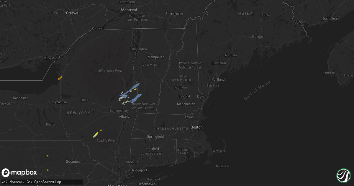
Hail Map in Vermont on May 29, 2020
Get this storm
May 29 map
$229
one time, instant access
Download today. No call, no setup
Keep the $229
Bought the map and want the full workflow? Apply the entire $229 to a subscription within 7 days. None of it is wasted.
Every map, not just this one
This buys you this map. Subscription and you get every map we run, in the markets you choose from a few cities to whole states to nationwide. Plus real-time alerts the moment a storm fires.
Contact data
Name, contact info, occupancy, even credit band for addresses in the footprint. You go from where it hit to who to call.
Become the source they trust
Unlimited branding weather history reports on demand. You already have the documented answer ready for the property owner, and you are the one who showed up with it.
Property data and RoofTrace estimates
Pull up any address you have got, its value and the exact code rules for that jurisdiction, straight from One Click Code. Then RoofTrace estimates the squares, pitch, and roof value, priced the way you price.
Storm reports in Vermont
Vermont
| Date | Description |
|---|---|
| 05/29/20206:51 PM CDT | Trees down on power lines causing outages |
| 05/29/20206:42 PM CDT | Trees down on power lines. |
| 05/29/20205:37 PM CDT | Reports of multiple trees down in the poultney area. Power outages also being reported. |
| 05/29/20203:40 PM CDT | Trees down on lines causing power outages. |
| 05/29/20202:53 PM CDT | Tree down on macrae rd. In colchester |
| 05/29/20202:38 PM CDT | Many trees down near south poultney with power outages being reported. |
| 05/29/20203:53 AM CDT | At 852 PM EDT, severe thunderstorms were located along a line extending from 18 miles west of Coburn Gore to near Pittsburg to 9 miles southwest of Stratford, moving northeast at 50 mph. HAZARD...60 mph wind gusts and penny size hail. SOURCE...Radar indicated. IMPACT...Expect damage to roofs, siding, and trees. Locations impacted include... Colebrook, Coburn Gore, Rangeley, Errol, Dixville, Stratford, Pittsburg, Columbia, Dummer, Clarksville, Upper Cupsuptic, Tim Pond, Davis, Lynchtown, Alder Stream, Merrill Strip, Chain Of Ponds, Bowmantown, Lincoln Plantation and Lower Cupsuptic.This also includes... First Connecticut Lake, Dixville Notch State Park, Coleman StatePark, Lake Francis State Park, and Percy Peaks. |
| 05/29/20203:26 AM CDT | At 825 PM EDT, severe thunderstorms were located along a line extending from 19 miles northwest of Franconia to 6 miles southwest of Littleton to 8 miles northwest of Lincoln to 7 miles west of Woodstock, moving northeast at 45 mph. HAZARD...60 mph wind gusts. SOURCE...Radar indicated. IMPACT...Expect damage to roofs, siding, and trees. Locations impacted include... Berlin, Littleton, Lancaster, Bethlehem, Lincoln, Haverhill, Franconia, Pinkham Notch, Mount Washington, Woodstock, Carroll, Gorham, Bartlett, Lisbon, Jefferson, Bath, Dalton, Jackson, Benton and Easton.This includes Interstate 93 between mile markers 99 and 131. This also includes... Crawford Notch State Park, Franconia Notch, Kilkenny Ridge Trail,Mount Moosilauke, and Cannon Mountain. |
| 05/29/20203:21 AM CDT | At 820 PM EDT, severe thunderstorms were located along a line extending from 20 miles west of Pittsburg to 10 miles west of Colebrook to 19 miles northwest of Littleton, moving northeast at 40 mph. HAZARD...60 mph wind gusts and quarter size hail. SOURCE...Radar indicated. IMPACT...Hail damage to vehicles is expected. Expect wind damage to roofs, siding, and trees. Locations impacted include... Colebrook, Errol, Pittsburg, Stratford, Dixville, Columbia, Dummer, Clarksville, Stewartstown, Northumberland, Stark and Wentworth Location.This also includes... First Connecticut Lake, Dixville Notch State Park, Coleman StatePark, Lake Francis State Park, and Percy Peaks. |
| 05/29/20203:18 AM CDT | At 818 PM EDT, a severe thunderstorm was located near Shaftsbury, or 7 miles southwest of Arlington, moving northeast at 45 mph. HAZARD...60 mph wind gusts and quarter size hail. SOURCE...Radar indicated. IMPACT...Hail damage to vehicles is expected. Expect wind damage to roofs, siding, and trees. Locations impacted include... Bennington, Hoosick Falls, Arlington, Shaftsbury, Grafton, Cambridge, Brunswick, Hoosick, Lee, Pittstown, Poestenkill, White Creek, North Bennington, Sunderland, Schaghticoke, Valley Falls, Sandgate, Old Bennington, Glastenbury and Schaghticoke Hill. |
| 05/29/20202:41 AM CDT | At 741 PM EDT, a severe thunderstorm was located over Manchester Center, or near Manchester, moving northeast at 50 mph. HAZARD...60 mph wind gusts and quarter size hail. SOURCE...Radar indicated. IMPACT...Hail damage to vehicles is expected. Expect wind damage to roofs, siding, and trees. This severe thunderstorm will be near... Londonderry around 755 PM EDT.Other locations impacted by this severe thunderstorm include StrattonValley, Beartown, Bondville, Peru Town Center, Stratton Acres,Rawsonville, Intervale, Barnumville, Freedleyville and Thompsonburg. |
| 05/29/20202:31 AM CDT | At 731 PM EDT, a severe thunderstorm was located near Hardwick, moving northeast at 40 mph. HAZARD...60 mph wind gusts and quarter size hail. SOURCE...Radar indicated. IMPACT...Minor hail damage to vehicles is possible. Expect wind damage to trees and powerlines. Locations impacted include... Lyndon, Greensboro, Westmore, Stannard, Orleans Village, Glover, Hardwick, Brownington, Burke, Sutton, Wolcott, Barton, Greensboro Bend, Sheffield, Newark, Newark Hollow, Brownington Village, West Burke Village, East Haven and Woodbury. |
| 05/29/20201:52 AM CDT | At 652 PM EDT, severe thunderstorms were located along a line extending from Hartford to near Salem to near Mechanicville, moving northeast at 40 mph. HAZARD...60 mph wind gusts and quarter size hail. SOURCE...Radar indicated. IMPACT...Hail damage to vehicles is expected. Expect wind damage to roofs, siding, and trees. Severe thunderstorms will be near... Hartford around 655 PM EDT. Granville around 705 PM EDT. Cambridge and Greenwich around 715 PM EDT. Pawlet around 720 PM EDT. Salem around 730 PM EDT. Dorset around 745 PM EDT.Other locations impacted by these severe thunderstorms include DeansCorners, Grangerville, Willow Glen, Northumberland, Wayville,Truthville, Middle Falls, West Pawlet, Mannings Cove and Shushan. |
| 05/29/20201:26 AM CDT | At 626 PM EDT, a severe thunderstorm was located near Comstock, or near Whitehall, moving northeast at 40 mph. HAZARD...60 mph wind gusts and quarter size hail. SOURCE...Radar indicated. IMPACT...Hail damage to vehicles is expected. Expect wind damage to roofs, siding, and trees. Locations impacted include... Whitehall, Huletts Landing, Putnam, Mount Hope, Lock Twelve Marina, Dresden Center, South Bay, Putnam Station, South Bay Village, Snody Dock, Clemons, West Fort Ann, Grays Corner, Iron Furnace, Ottenburgs Ramp, Hogtown and East Whitehall. |
| 05/29/202012:57 AM CDT | At 556 PM EDT, severe thunderstorms were located along a line extending from near Corinth to Rotterdam Junction, moving northeast at 45 mph. HAZARD...60 mph wind gusts and quarter size hail. SOURCE...Radar indicated. IMPACT...Hail damage to vehicles is expected. Expect wind damage to roofs, siding, and trees. Severe thunderstorms will be near... Corinth around 600 PM EDT. Glens Falls, Hudson Falls, Glens Falls North, West Glens Falls and Country Knolls around 610 PM EDT. Ballston Spa, Round Lake, North Ballston Spa and Rock City Falls around 615 PM EDT. Milton around 620 PM EDT. Saratoga Springs and Comstock around 625 PM EDT. Poultney Village around 640 PM EDT. Fort Edward around 645 PM EDT. Granville and Hartford around 700 PM EDT.Other locations impacted by these severe thunderstorms include DeansCorners, Glenridge, Grangerville, Harding Crossing, West Milton,Willow Glen, Northumberland, Garrison Manor, Wayville and GreenfieldCenter. |
| 05/29/202012:22 AM CDT | At 521 PM EDT, a severe thunderstorm was located over Day Center, or 17 miles southwest of Lake George Village, moving northeast at 50 mph. HAZARD...60 mph wind gusts and quarter size hail. SOURCE...Radar indicated. IMPACT...Hail damage to vehicles is expected. Expect wind damage to roofs, siding, and trees. This severe thunderstorm will be near... Lake Luzerne-Hadley around 530 PM EDT. Lake Luzerne Campground around 535 PM EDT. Lake George Village around 540 PM EDT. Warrensburg and Chestertown around 550 PM EDT. Bolton Landing around 555 PM EDT. Huletts Landing around 605 PM EDT. Hague around 610 PM EDT. Rogers Rock Campground around 615 PM EDT.Other locations impacted by this severe thunderstorm include ThurmanStation, Cleverdale, Beartown, Tenantville, Lake Luzerne, PutnamStation, South Bay Village, Snody Dock, Conklingville and Sabbath DayPoint. |
| 05/28/202010:33 PM CDT | At 333 PM EDT, a severe thunderstorm was located over West Castleton, moving northeast at 35 mph. HAZARD...60 mph wind gusts and quarter size hail. SOURCE...Radar indicated. IMPACT...Minor hail damage to vehicles is possible. Expect wind damage to trees and powerlines. Locations impacted include... Rutland, Sudbury, Hancock, Hubbardton, Ripton, Bethel, Proctor, Rochester, Brandon, Chittenden, Leicester, Pittsfield, Pittsford, Granville, Goshen, Braintree, West Rutland, Warren, Salisbury and Stockbridge. |
| 05/28/202010:29 PM CDT | At 328 PM EDT, a severe thunderstorm was located over Granville, or 12 miles southeast of Whitehall, moving northeast at 35 mph. HAZARD...60 mph wind gusts and quarter size hail. SOURCE...Radar indicated. IMPACT...Hail damage to vehicles is expected. Expect wind damage to roofs, siding, and trees. This severe thunderstorm will remain over mainly rural areas of east central Washington County, including the following locations... Raceville, Middle Granville, Slyboro and South Granville. |
| 05/28/20209:24 PM CDT | At 224 PM EDT, severe thunderstorms were located along a line extending from West Glens Falls to near Rock City Falls, moving northeast at 35 mph. HAZARD...60 mph wind gusts and quarter size hail. SOURCE...Radar indicated. IMPACT...Hail damage to vehicles is expected. Expect wind damage to roofs, siding, and trees. Locations impacted include... Saratoga Springs, Glens Falls, Hudson Falls, Warrensburg, Whitehall, Lake George Village, Fort Edward, Corinth, Granville, Hartford, Galway, Comstock, Rock City Falls, Glens Falls North, West Glens Falls, Lake Luzerne Campground, Kings, Mount Pleasant, Queensbury and Wilton. |
| 05/28/20207:12 PM CDT | Trees down on derby road. |
| 05/28/20207:08 PM CDT | Multiple trees down with one tree damaging an outbuilding. |
All States Impacted by Hail Map on May 29, 2020
Cities Impacted by Hail Map on May 29, 2020
- Douglas, WY
- Meriden, WY
- Bishopville, SC
- Hartsville, SC
- Cheyenne, WY
- New Raymer, CO
- Dublin, OH
- Granville, NY
- Minatare, NE
- Hill City, SD
- Newcastle, WY
- Burns, WY
- Glendo, WY
- Wheatland, WY
- Punxsutawney, PA
- Reynoldsville, PA
- Glenrock, WY
- Batesburg, SC
- Leesville, SC
- Saluda, SC
- Malta, ID
- Latta, SC
- Watkins, CO
- Aurora, CO
- Andes, NY
- Clifton, AZ
- Croton, OH
- Sunbury, OH
- Centerburg, OH
- Kaycee, WY
- Carpenter, WY
- Schuylerville, NY
- Stillwater, NY
- Saratoga Springs, NY
- Bennett, CO
- Dalzell, SC
- Rembert, SC
- Camden, SC
- Scottsbluff, NE
- Marietta, GA
- Grass Valley, CA
- Simpsonville, SC
- Fountain Inn, SC
- Pelzer, SC
- Yoder, WY
- Ballston Spa, NY
- Columbia, SC
- Hopkins, SC
- Lamar, SC
- Rock Hill, SC
- Darlington, SC
- Society Hill, SC
- Corinth, NY
- Hadley, NY
- Lake Luzerne, NY
- Copenhagen, NY
- Rodman, NY
- Lorraine, NY
- Colfax, CA
- Medicine Bow, WY
- Clermont, FL
- Montverde, FL
- Delancey, NY
- Jonestown, PA
- Pine Grove, PA
- Fredericksburg, PA
- Sonoita, AZ
- London, OH
- South Vienna, OH
- Torrington, WY
- Millerstown, PA
- Liverpool, PA
- Veteran, WY
- Myers Flat, CA
- Shepherdstown, WV
- Sharpsburg, MD
- Keedysville, MD
- Lincoln, CA
- Gansevoort, NY
- West Columbia, SC
- Gaston, SC
- Porter Corners, NY
- Greenfield Center, NY
- Margaretville, NY
- Roscoe, NY
- Weimar, CA
- Penn Valley, CA
- Rough And Ready, CA
- Cayce, SC
- Chugwater, WY
- Batesland, SD
- Rockland, ID
- Kyle, SD
- Mount Pleasant Mills, PA
- Bradford, PA
- Strasburg, CO
- Foresthill, CA
- Webbville, KY
- Fort Edward, NY
- Dunnellon, FL
- Porcupine, SD
- Martin, SD
- Middle Grove, NY
- Rock City Falls, NY
- Edinburg, VA
- Mount Jackson, VA
- Hudson Falls, NY
- Fort Ann, NY
- Sandy Hook, KY
- Isonville, KY
- Yuba City, CA
- Belton, SC
- Piedmont, SC
- Timmonsville, SC
- Shenandoah Junction, WV
- Swiss, WV
- Summersville, WV
- Millville, PA
- Muncy, PA
- Bloomsburg, PA
- Halifax, PA
- Tower City, PA
- Aspers, PA
- Gardners, PA
- Pottsville, PA
- Schuylkill Haven, PA
- Cressona, PA
- Forksville, PA
- New Albany, PA
- Louisa, KY
- Comstock, NY
- South Glens Falls, NY
- Middle Granville, NY
- Poultney, VT
- Whitehall, NY
- North Granville, NY
- Glens Falls, NY
- Queensbury, NY
- Hampton, NY
- Cambridge, NY
- Salem, NY
- Arlington, VT
- Dorset, VT
- Greenwich, NY
- Shushan, NY
- West Rupert, VT
- Cochranton, PA
- Townville, PA
- Guys Mills, PA
- Spartansburg, PA
- Centerville, PA
- Meadville, PA
- Grand Valley, PA
- Clarendon, PA
- Youngsville, PA
- Irvine, PA
- Warren, PA
- Pittsfield, PA
- Titusville, PA
- Tidioute, PA
- Mannsville, NY
- Pulaski, NY
- Adams, NY
- Sandy Creek, NY
- Roxbury, NY


