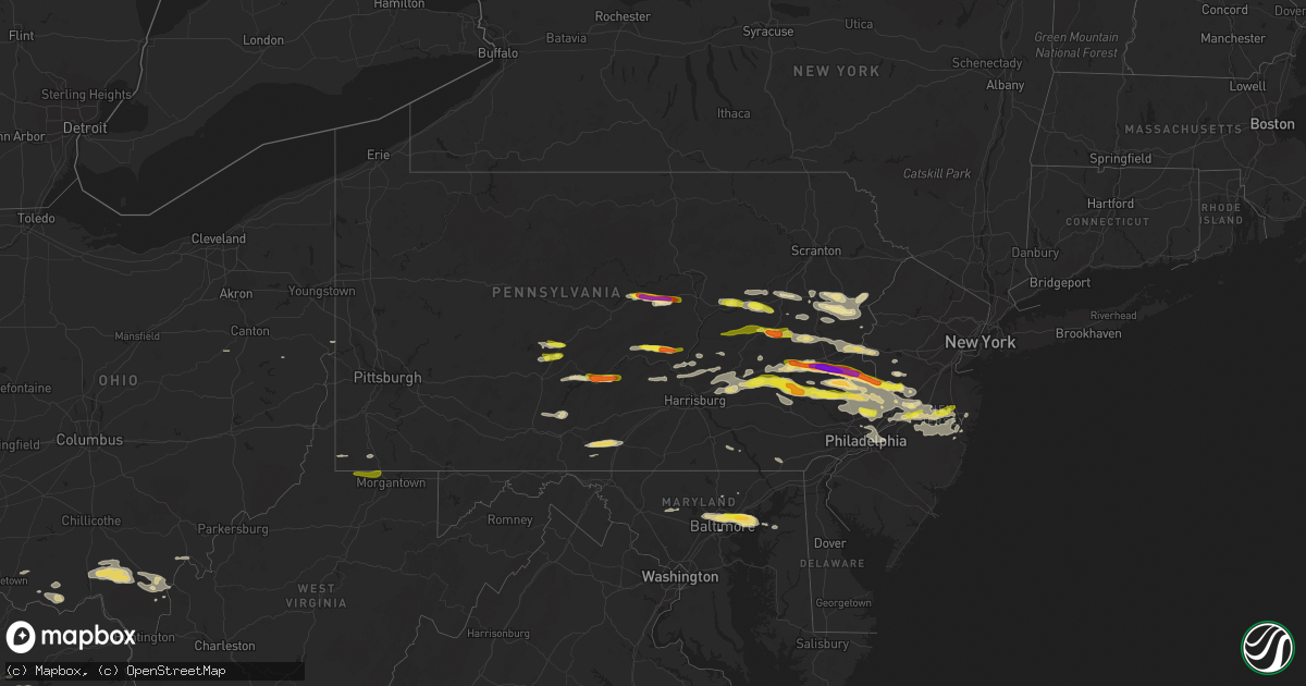
Hail Map in Pennsylvania on May 29, 2019
Get this storm
May 29 map
$229
one time, instant access
Download today. No call, no setup
Keep the $229
Bought the map and want the full workflow? Apply the entire $229 to a subscription within 7 days. None of it is wasted.
Every map, not just this one
This buys you this map. Subscription and you get every map we run, in the markets you choose from a few cities to whole states to nationwide. Plus real-time alerts the moment a storm fires.
Contact data
Name, contact info, occupancy, even credit band for addresses in the footprint. You go from where it hit to who to call.
Become the source they trust
Unlimited branding weather history reports on demand. You already have the documented answer ready for the property owner, and you are the one who showed up with it.
Property data and RoofTrace estimates
Pull up any address you have got, its value and the exact code rules for that jurisdiction, straight from One Click Code. Then RoofTrace estimates the squares, pitch, and roof value, priced the way you price.
Storm reports in Pennsylvania
Pennsylvania
| Date | Description |
|---|---|
| 05/29/20195:35 PM CDT | Tree down. |
| 05/29/20195:24 PM CDT | Downed utility on paoli pike near grubb road. Time estimated from radar. |
| 05/29/20195:19 PM CDT | Delayed report. Downed tree blocking holme road between winchester and nazareth. Time estimated from radar. |
| 05/29/20195:15 PM CDT | A local report indicates 59 MPH wind near NORTHEAST PHILADELPHIA |
| 05/29/20195:15 PM CDT | Corrects previous hail report from bensalem. |
| 05/29/20195:10 PM CDT | A local report indicates 1.00 inch wind near WILLOW GROVE |
| 05/29/20195:10 PM CDT | A local report indicates 1.00 inch wind near WILLOW GROVE |
| 05/29/20195:10 PM CDT | A local report indicates 1.00 inch wind near 2 SSE WARMINSTER TWP |
| 05/29/20195:10 PM CDT | Time estimated from radar. |
| 05/29/20195:06 PM CDT | Tree down on waterloo rd. Time estimated from radar. |
| 05/29/20195:05 PM CDT | A local report indicates 1.00 inch wind near BENSALEM |
| 05/29/20194:54 PM CDT | Trees down across the southbound lanes of i-83 near the leader heihgts exit. |
| 05/29/20194:52 PM CDT | Trees down on structures in the 400 block of smith street. |
| 05/29/20194:50 PM CDT | Home reported damaged on walnut ln with resident needing assistance to be extracted. Time estimated from radar. |
| 05/29/20194:50 PM CDT | A local report indicates 1.00 inch wind near RICHLAND TWP |
| 05/29/20194:49 PM CDT | Numerous trees down. |
| 05/29/20194:45 PM CDT | Multiple trees down with power outages. Time estimated from radar. |
| 05/29/20194:42 PM CDT | Trees snapped and some uprooted... Shingles torn off... Barn about 1/2 mile away was blown down. Also reported hail the size of nickels. Time estimated from radar. |
| 05/29/20194:41 PM CDT | Numerous trees down near elk drive in hanover. |
| 05/29/20194:39 PM CDT | Delayed report. Downed tree on route 724 near the chester county line. Time estimated from radar. |
| 05/29/20194:38 PM CDT | Multiple trees reported down at the landis parking lot in harleysville. Time estimated from radar. |
| 05/29/20194:35 PM CDT | Photo of a large tree snapped near the base. |
| 05/29/20194:35 PM CDT | Many large tree branches |
| 05/29/20194:35 PM CDT | Trees reported down in boyertown. Time estimated from radar. |
| 05/29/20194:34 PM CDT | Delayed report of downed tree blocking the roadway on cedar hill road north of cocalico road. Time estimated from radar. |
| 05/29/20194:25 PM CDT | Tree down onto wires. Time estimated from radar. |
| 05/29/20194:24 PM CDT | Delayed report of trees down on museum road between lancaster avenue and old mill road. Time estimated from radar. |
| 05/29/20194:19 PM CDT | Delayed report of tree and wires down on river road in muhlenberg twp. Time estimated from radar. |
| 05/29/20194:15 PM CDT | Trees and power lines reported down. |
| 05/29/20194:12 PM CDT | Measured by a personal weather station. Time estimated from radar. |
| 05/29/20194:05 PM CDT | Wires down... Along with large branches. Time estimated from radar. |
| 05/29/20194:00 PM CDT | Numerous trees down. |
| 05/29/20194:00 PM CDT | Trees down in woxall/upper salford twp. |
| 05/29/20194:00 PM CDT | Numerous trees down. Time estimated from radar. |
| 05/29/20194:00 PM CDT | Numerous trees and wires down in west labonon twp. |
| 05/29/20193:56 PM CDT | A local report indicates 1.00 inch wind near GREEN LANE |
| 05/29/20193:55 PM CDT | Report of trees down. Time estimated from radar. |
| 05/29/20193:55 PM CDT | Neiffer rd closed from rte 73 to ridge pike due to downed trees. Time estimated from radar. |
| 05/29/20193:55 PM CDT | Several trees and power lines down. Time estimated from radar. |
| 05/29/20193:53 PM CDT | Multiple trees down in pine grove twp. |
| 05/29/20193:51 PM CDT | A local report indicates 77 MPH wind near 2 WSW LENHARTSVILLE |
| 05/29/20193:48 PM CDT | Trees snapped in fort loudon. |
| 05/29/20193:48 PM CDT | At least one large tree down. Time estimated from radar. |
| 05/29/20193:45 PM CDT | Barn collapse and damage to multiple pine trees. |
| 05/29/20193:40 PM CDT | Delayed report from wednesday. Time estimated from radar. |
| 05/29/20193:40 PM CDT | Delayed report. Several reports of trees and wires down in douglass twp... Including on poplar road... Reading avenue... And trout run road. Time estimated from radar. |
| 05/29/20193:38 PM CDT | Large trees down in three springs. |
| 05/29/20193:37 PM CDT | Delayed report. Several reports of trees down in earl twp and oley twp... Including on sheep hill road... Pine road... And saw mill road in earl twp and main street and |
| 05/29/20193:35 PM CDT | Tree down across rd. Time estimated from radar. |
| 05/29/20193:34 PM CDT | Tree down on somerset pike. |
| 05/29/20193:33 PM CDT | Several trees down in wells twp. Two barn roofs blown off. Partial damage to roof of home. Time estimated from radar. |
| 05/29/20193:32 PM CDT | Downed tree on wires on vera cruz rd. Time estimated from radar. |
| 05/29/20193:30 PM CDT | Multiple large trees snapped or uprooted. Public report relayed by emergency management. Time estimated. |
| 05/29/20193:27 PM CDT | Numerous trees and wires down. Barn roof partially blown off on parker dr. Damage to shelters and buildings in camp hedron. |
| 05/29/20193:26 PM CDT | Time estimated from radar. |
| 05/29/20193:25 PM CDT | Numerous trees down. Spotter estimated wind gust of 90 mph. |
| 05/29/20193:25 PM CDT | Ef1 with max winds around 100 mph. Path length 3/4 miles. Tornado width 50 yards. |
| 05/29/20193:24 PM CDT | An ef1 tornado touched down near rt 225 n of matamoras rd and traveled 2.5 miles ese into camp hebron. Max path width 500 yards... Max winds 100 mph. Numerous trees upr |
| 05/29/20193:24 PM CDT | Mobile home destroyed on sherman valley rd. Dozens of trees down across county. |
| 05/29/20193:23 PM CDT | Delayed report of tree down on friedensburg road in lower alsace twp. Time estimated from radar. |
| 05/29/20193:23 PM CDT | Delayed report of trees and wires down near the intersection of 23rd street and cumberland avenue. Time estimated from radar. |
| 05/29/20193:20 PM CDT | Numerous trees down in watts... Miller... And buffalo twps... Including cluster trees in watts twp. |
| 05/29/20193:19 PM CDT | Trees down. |
| 05/29/20193:18 PM CDT | Several reports of hail up to quarter size in laureldale and muhlenberg twp. Time estimated from radar. |
| 05/29/20193:18 PM CDT | Delayed report. Several reports of trees down on conrad road in district twp. Time estimated from radar. |
| 05/29/20193:18 PM CDT | Delayed report of trees and power lines down on long lane in hereford twp. Time estimated from radar. |
| 05/29/20193:17 PM CDT | Numerous trees down in watts... Miller... And buffalo twps... Including cluster trees in watts twp. |
| 05/29/20193:14 PM CDT | An ef1 tornado touched down south-southeast of newport and traveled approximately 4.8 miles before lifting just east of the juniata river. Maximum path width was approx |
| 05/29/20193:12 PM CDT | Delayed report. Several reports of trees and power lines down in pike twp... Including on hill church road... Merkle road... And lutz road. Time estimated from radar. |
| 05/29/20193:09 PM CDT | Several large trees broken and small trees snapped at the trunk. |
| 05/29/20193:07 PM CDT | Multiple trees down on holfa mill rd in lewisburg pa. |
| 05/29/20193:05 PM CDT | Trees and wires down in saville... Centre... And spring twps. |
| 05/29/20193:03 PM CDT | A local report indicates 60 MPH wind near EFFORT |
| 05/29/20193:02 PM CDT | Tree down on road. Time estimated from radar. |
| 05/29/20193:00 PM CDT | Pa 192 and pa 45 closed from mifflinburg to laurltown due to trees and wires down. 50 to 100 trees down in west buffalo twp. |
| 05/29/20193:00 PM CDT | Trees down on muddy run rd and paradise rd in turbot twp. |
| 05/29/20192:59 PM CDT | Delayed report of tree down near the intersection of crystal cave road and dunkles church road in richmond twp. Time estimated from radar. |
| 05/29/20192:56 PM CDT | Delayed report. Downed tree and wires on stone road near route 419 in tulpehocken twp. Time estimated from radar. |
| 05/29/20192:55 PM CDT | A local report indicates 1.50 inch wind near QUAKERTOWN |
| 05/29/20192:55 PM CDT | Trees down |
| 05/29/20192:52 PM CDT | Multiple trees snapped. Observer reported a swath of trees down on the hillside behind her house. |
| 05/29/20192:50 PM CDT | Numerous trees and wires down. Dozens of evergreens snapped. Time estimated from radar. |
| 05/29/20192:45 PM CDT | Time estimated from radar. |
| 05/29/20192:43 PM CDT | A local report indicates 1.00 inch wind near BEDMINSTER |
| 05/29/20192:43 PM CDT | Corrects previous tstm wnd dmg report from 1 w swiftwater. Delayed report. Downed tree on summit road near swiftwater forcing its closure. Time estimated from radar. |
| 05/29/20192:43 PM CDT | Multiple trees down in muncy creek twp. Time estimated from radar. |
| 05/29/20192:35 PM CDT | Several trees downed or snapped. |
| 05/29/20192:35 PM CDT | Several uprooted and snapped trees on windy valley rd. Downed trees damaged fence and bleachers at creek junction park. |
| 05/29/20192:35 PM CDT | Downed tree in wires on school house rd. Time estimated from radar. |
| 05/29/20192:30 PM CDT | Tree down on rt 22 near flowing spring rd. |
| 05/29/20192:29 PM CDT | Trees down near crystal lake road and old baker road |
| 05/29/20192:27 PM CDT | Tree down on wires in greenfield township |
| 05/29/20192:26 PM CDT | Trees and wires down near 1926 pierce road in greenfield township. |
| 05/29/20192:26 PM CDT | Hail fell for approx 10 minutes. Widespread quarter to half dollar sized hail with 2 inch hail included. |
| 05/29/20192:26 PM CDT | Large trees down... Garage crushed... And portion of roof blown off of a house near newton lake. |
| 05/29/20192:23 PM CDT | Trees and wires down on w 1st st. |
| 05/29/20192:21 PM CDT | Photos of hail larger than golf balls in coopersburg. Time estimated from radar. |
| 05/29/20192:21 PM CDT | Trees down |
| 05/29/20192:20 PM CDT | Numerous trees and wires down in pine creek twp. |
| 05/29/20192:20 PM CDT | A local report indicates 1.00 inch wind near QUAKERTOWN |
| 05/29/20192:20 PM CDT | Ef-0 with max winds of 75 mph. Path length of 0.2 miles and path width of 50 yards. |
| 05/29/20192:19 PM CDT | Numerous trees and wires down in lock haven. |
| 05/29/20192:19 PM CDT | Time estimated from radar. |
| 05/29/20192:17 PM CDT | Delayed report. Downed trees on mountain drive. Time estimated from radar. |
| 05/29/20192:16 PM CDT | Multiple trees down. Time estimated from radar. |
| 05/29/20192:15 PM CDT | A local report indicates 1.50 inch wind near EMMAUS |
| 05/29/20192:15 PM CDT | Trees and wires down near 326 blue ridge trail |
| 05/29/20192:14 PM CDT | Time estimated from radar. |
| 05/29/20192:14 PM CDT | Nws storm survey confirmed an ef-0 tornado developed in lower milford twp in lehigh county. Trees were snapped and uprooted along its 2.3 mile path into northern milfor |
| 05/29/20192:12 PM CDT | Tree down on castle farms rd. |
| 05/29/20192:08 PM CDT | A local report indicates 1.75 inch wind near MACUNGIE |
| 05/29/20192:05 PM CDT | Several trees down |
| 05/29/20192:05 PM CDT | A local report indicates 1.00 inch wind near 3 SW RICHFIELD |
| 05/29/20192:00 PM CDT | A local report indicates 1.00 inch wind near BREINIGSVILLE |
| 05/29/20192:00 PM CDT | A local report indicates 1.25 inch wind near EMMAUS |
| 05/29/20192:00 PM CDT | A local report indicates 1.50 inch wind near 2 N MCALISTERVILLE |
| 05/29/20191:53 PM CDT | Time estimated from radar. |
| 05/29/20191:50 PM CDT | Hail up to 2 inches reported in mertztown. |
| 05/29/20191:50 PM CDT | Trees down in center township. Time estimated from radar. |
| 05/29/20191:48 PM CDT | Multiple trees down in barr twp. Time estimated from radar. |
| 05/29/20191:47 PM CDT | Several trees down at rt 819 and hancock ave |
| 05/29/20191:46 PM CDT | Trees and wires down at golf course rd and crawford rd in sinking valley. |
| 05/29/20191:45 PM CDT | A local report indicates 1.00 inch wind near TREXLERTOWN |
| 05/29/20191:44 PM CDT | Portions of rt 120 closed between lock haven and ronovo due to trees down on rd. |
| 05/29/20191:44 PM CDT | Wires down in roadway with pole snapped. |
| 05/29/20191:42 PM CDT | Trees and wires down near mud pond |
| 05/29/20191:32 PM CDT | Trees and wires down. |
| 05/29/20191:31 PM CDT | Trees down. |
| 05/29/20191:30 PM CDT | Large tree down on vehicle. |
| 05/29/20191:25 PM CDT | Multiple trees down just west of covington. |
| 05/29/20191:22 PM CDT | Trees and wires down. |
| 05/29/20191:10 PM CDT | Utility pole down on e valley rd. |
| 05/29/20191:07 PM CDT | Ef-0 tornado with max winds of 75 mph. Path length of 1 mile and path width of 50 yards. |
| 05/29/20191:07 PM CDT | Shed destroyed. Flatbed truck laying on its side. A few trees down. |
| 05/29/20191:05 PM CDT | Trees down on kepple rd in jackson twp. Time estimated from radar. |
| 05/29/20191:03 PM CDT | Golf ball sized hail reported near loganton. |
| 05/29/20191:00 PM CDT | Multiple trees down on hills creek lake rd. Time estimated from radar. |
| 05/29/201912:40 PM CDT | A local report indicates 1.00 inch wind near TYRONE |
| 05/29/201912:35 PM CDT | A local report indicates 1.00 inch wind near TYRONE |
| 05/29/201911:58 AM CDT | Trees and wires down |
| 05/29/20197:57 AM CDT | At 1256 PM EDT, a severe thunderstorm was located over Kane, moving east at 40 mph. HAZARD...60 mph wind gusts and penny size hail. SOURCE...Radar indicated. IMPACT...Expect damage to trees, roofs, and siding. Locations impacted include... St. Marys, Kane, Smethport, Wetmore, Betula, Wilcox, James City, Crosby, East Branch Dam, Elk River, Westline, Kinzua Bridge State Park, Truman, Sizerville, Mount Jewett and Bradford Airport. |
| 05/29/20191:29 AM CDT | At 628 PM EDT, a severe thunderstorm was located near Cherry Hill Mall, or 7 miles northeast of Camden, moving east at 45 mph. HAZARD...60 mph wind gusts and quarter size hail. SOURCE...Radar indicated. IMPACT...Minor damage to vehicles is possible. Wind damage to roofs, siding, trees, and power lines is possible. Locations impacted include... Philadelphia, Camden, Gloucester City, Cherry Hill, Evesham, Mount Laurel, Willingboro, Deptford, Voorhees, Medford, West Deptford, Barnegat, Glassboro, Lindenwold, Hammonton, Lumberton, Bellmawr, Woodbury, Mount Holly and Pitman. |
| 05/29/20191:06 AM CDT | At 606 PM EDT, a severe thunderstorm was located over Hatboro, or 11 miles north of Philadelphia, moving east at 40 mph. HAZARD...60 mph wind gusts and quarter size hail. SOURCE...Radar indicated. IMPACT...Minor damage to vehicles is possible. Wind damage to roofs, siding, trees, and power lines is possible. Locations impacted include... Philadelphia, Trenton, Bensalem, Willingboro, Florence, Burlington, Bristol, Riverside, Hatboro, Jenkintown, Beverly, Rockledge, Newtown, Tullytown, Abington, Langhorne, Bryn Athyn, Ivyland, Feasterville-Trevose and Florence-Roebling. |
| 05/29/201912:23 AM CDT | At 522 PM EDT, severe thunderstorms were located along a line extending from near Greendell to near Birdsboro, moving east at 90 mph. HAZARD...60 mph wind gusts and quarter size hail. SOURCE...Radar indicated. IMPACT...Minor damage to vehicles is possible. Wind damage to roofs, siding, trees, and power lines is possible. Locations impacted include... Allentown, Reading, Easton, Newton, Bethlehem, Pottstown, Phoenixville, Hopatcong, Forks, Emmaus, Wyomissing, Northampton, East Stroudsburg, Hackettstown, Quakertown, Perkasie, Wilson, Souderton, Bedminster and Wharton. |
| 05/28/201911:53 PM CDT | At 452 PM EDT, a severe thunderstorm was located near Green Lane, or 18 miles south of Allentown, moving east at 35 mph. HAZARD...Two inch hail and 70 mph wind gusts. SOURCE...Radar indicated. IMPACT...People and animals outdoors will be injured. Expect hail damage to roofs, siding, windows, and vehicles. Expect considerable tree damage. Wind damage is also likely to mobile homes, roofs, and outbuildings. Locations impacted include... Trenton, Ewing, Pottstown, Lansdale, Burlington, Bristol, Quakertown, Perkasie, Doylestown, Byram, Hatboro, Souderton, Bedminster, Chalfont, Tinicum, Hatfield, East Greenville, Pennington, New Hope and Yardley. |
| 05/28/201911:50 PM CDT | At 450 PM EDT, severe thunderstorms were located along a line extending from near Lehighton to near Hummelstown, moving southeast at 50 mph. HAZARD...60 mph wind gusts and quarter size hail. SOURCE...Radar indicated. IMPACT...Minor damage to vehicles is possible. Wind damage to roofs, siding, trees, and power lines is possible. Locations impacted include... Allentown, Reading, Bethlehem, Pottstown, Emmaus, Wyomissing, Northampton, Birdsboro, Kutztown, Jim Thorpe, Hamburg, Slatington, Fleetwood, Sinking Spring, Laureldale, Womelsdorf, Wernersville, Newmanstown, Walnutport and Topton. |
| 05/28/201911:42 PM CDT | At 441 PM EDT, a severe thunderstorm was located near White Haven, or 11 miles north of Lehighton, moving east at 30 mph. HAZARD...60 mph wind gusts and penny size hail. SOURCE...Radar indicated. IMPACT...Damage to roofs, siding, trees, and power lines is possible. Locations impacted include... Lehighton, Mount Pocono, Bethlehem, Northampton, East Stroudsburg, Tobyhanna, Nazareth, Palmerton, Bangor, Jim Thorpe, Slatington, Pen Argyl, Nesquehoning, Wind Gap, Bath, Weatherly, Walnutport, Belfast, Tatamy and East Bangor. |
| 05/28/201911:36 PM CDT | At 436 PM EDT, severe thunderstorms were located along a line extending from near Dehart Dam to Rockville to near Shermansdale, moving east at 50 mph. HAZARD...60 mph wind gusts and quarter size hail. SOURCE...Radar indicated. IMPACT...Hail damage to vehicles is expected. Expect wind damage to trees, roofs, and siding. Locations impacted include... Lancaster, Harrisburg, Lower Allen, Hershey, Ephrata, Colonial Park, Elizabethtown, Progress, Lititz, Mechanicsburg, Middletown, Camp Hill, Mount Joy, Palmyra, New Cumberland, Linglestown, Enola, Steelton, New Holland and Manheim.This includes the following Interstates... The Pennsylvania Turnpike from mile markers 235 to 295. Interstate 81 from mile markers 53 to 79. Interstate 83 from mile markers 31 to 50. Interstate 283 from mile markers 0 to 2. |
| 05/28/201911:30 PM CDT | At 429 PM EDT, a severe thunderstorm was located over Waterfall, moving east at 60 mph. HAZARD...Ping pong ball size hail and 60 mph wind gusts. SOURCE...Radar indicated. IMPACT...People and animals outdoors will be injured. Expect hail damage to roofs, siding, windows, and vehicles. Expect wind damage to trees, roofs, and siding. Locations impacted include... Shippensburg, Mount Union, Waterfall, Rockhill Furnace, Wells Tannery, Fort Littleton, Dudley, Willow Hill, Fannettsburg, Roxbury, Doylesburg, Upper Strasburg, Trough Creek State Park, Sideling Hill Rest Area, Broad Top City, Three Springs, Mapleton, Orbisonia, Saltillo and Kistler.This includes the following Interstates... The Pennsylvania Turnpike between mile markers 171 and 174...nearmile marker 176...and from mile markers 179 to 201. Interstate 81 near mile marker 25. |
| 05/28/201911:29 PM CDT | At 428 PM EDT, severe thunderstorms were located along a line extending from Trevorton to Klingerstown to Elizabethville to near New Buffalo, moving east at 55 mph. HAZARD...60 mph wind gusts and quarter size hail. SOURCE...Radar indicated. IMPACT...Hail damage to vehicles is expected. Expect wind damage to trees, roofs, and siding. Severe thunderstorms will be near... Lykens, Klingerstown, Williamstown and Leck Kill around 430 PM EDT. Shamokin, Kulpmont, Mount Carmel, Penn National Race Course, Tower City, Fort Indiantown Gap, Marshallton, Fairview-Ferndale and Dehart Dam around 440 PM EDT. Annville, Minersville, Ashland, Branchdale, Fredericksburg, Buck Run, Beurys Lake, Forrestville, Cleona and Pine Grove around 450 PM EDT. Schuylkill Haven, Myerstown, Lebanon, Pottsville, St. Clair, Renningers, Lebanon South, Richland, Avon and Friedensburg around 500 PM EDT.Other locations impacted by these severe thunderstorms includeRavine, Mary-D, Park Place, Ringtown, Deer Lake, Cumbola, MarionHeights, Landingville, Newtown and Ono.This includes the following Interstates... Interstate 78 from mile markers 0 to 8. Interstate 81 from mile markers 80 to 135. |
| 05/28/201911:24 PM CDT | At 424 PM EDT, a severe thunderstorm was located near Ligonier, moving east at 55 mph. HAZARD...60 mph wind gusts and quarter size hail. SOURCE...Radar indicated. IMPACT...Hail damage to vehicles is expected. Expect wind damage to trees, roofs, and siding. Locations impacted include... Somerset, Windber, Friedens, Boswell, Davidsville, Central City, Jerome, Acosta, Ogletown, Tire Hill, Jennerstown, Hooversville, Indian Lake, Stoystown, Shanksville, Benson and Flight 93 National Memorial.This includes The Pennsylvania Turnpike from mile markers 100 to 107. |
| 05/28/201911:18 PM CDT | At 418 PM EDT, severe thunderstorms were located along a line extending from near Sweet Valley to near Beach Haven to near Mainville, moving east at 55 mph. HAZARD...60 mph wind gusts and quarter size hail. SOURCE...Radar indicated. IMPACT...Hail damage to vehicles is expected. Expect wind damage to roofs, siding, and trees. Locations impacted include... Scranton, Wilkes-Barre, Hazleton, Muhlenberg, Dunmore, Kingston, Nanticoke, Plains, Old Forge and Pittston. |
| 05/28/201911:16 PM CDT | At 416 PM EDT, a severe thunderstorm was located over Jim Thorpe, or near Lehighton, moving east at 35 mph. HAZARD...60 mph wind gusts and half dollar size hail. SOURCE...Radar indicated. IMPACT...Minor damage to vehicles is possible. Wind damage to roofs, siding, trees, and power lines is possible. Locations impacted include... Easton, Lehighton, Bethlehem, Forks, Wilson, Nazareth, Palmerton, Bangor, Jim Thorpe, Slatington, Pen Argyl, Nesquehoning, Wind Gap, Bath, Weatherly, Walnutport, Belfast, West Easton, Tatamy and East Bangor. |
| 05/28/201911:13 PM CDT | At 412 PM EDT, a severe thunderstorm was located over Beersville, or 8 miles north of Allentown, moving east at 30 mph. HAZARD...60 mph wind gusts and quarter size hail. SOURCE...Radar indicated. IMPACT...Minor damage to vehicles is possible. Wind damage to roofs, siding, trees, and power lines is possible. Locations impacted include... Allentown, Easton, Bethlehem, Forks, Northampton, Wilson, Washington, Hellertown, Nazareth, High Bridge, Clinton, Bath, Harmony, Alpha, Glen Gardner, Belfast, Hampton, Frenchtown, West Easton and Milford. |
| 05/28/201911:13 PM CDT | At 412 PM EDT, a severe thunderstorm was located near Lawson Heights, or near Latrobe, moving east at 40 mph. HAZARD...Wind gusts to 60 mph. SOURCE...Radar. IMPACT...Expect damage to trees and power lines, resulting in some power outages. Locations impacted include... Latrobe... McChesneytown-Loyalhanna... Lawson Heights... Ligonier... Calumet-Norvelt... Youngstown... Laurel Mountain... Donegal... Champion... Acme... Jones Mills... Laurel Mountain State Park...This includes Pennsylvania Turnpike between mile markers 81 and 99. |
| 05/28/201911:09 PM CDT | At 409 PM EDT, a severe thunderstorm was located over Brodheadsville, or 14 miles south of Mount Pocono, moving east at 35 mph. HAZARD...70 mph wind gusts and quarter size hail. SOURCE...Radar indicated. IMPACT...Minor damage to vehicles is possible. Expect considerable tree damage. Wind damage is also likely to mobile homes, roofs, and outbuildings. Locations impacted include... Hackettstown, Washington, Bangor, Pen Argyl, Wind Gap, Belvidere, Harmony, Oxford, Belfast, East Bangor, Brass Castle, Stormville, Brodheadsville, Kunkletown, Gilbert, Rossland, Kresgeville, Pleasant Valley, Saylorsburg and McMichael. |
| 05/28/201911:06 PM CDT | At 405 PM EDT, a severe thunderstorm was located near Osterburg, moving east at 40 mph. HAZARD...60 mph wind gusts and quarter size hail. SOURCE...Radar indicated. IMPACT...Hail damage to vehicles is expected. Expect wind damage to trees, roofs, and siding. Locations impacted include... Bedford, Breezewood, New Enterprise, Everett, Osterburg, St. Clairsville, Blue Knob State Park, Queen, Cessna, Saxton, Schellsburg, Manns Choice, Woodbury, Defiance, Hopewell, New Paris and Blue Knob Ski Resort.This includes the following Interstates... Interstate 70 from mile markers 147 to 149. The Pennsylvania Turnpike near mile marker 138...and from milemarkers 140 to 165. Interstate 99 from mile markers 0 to 14. |
| 05/28/201910:53 PM CDT | At 353 PM EDT, severe thunderstorms were located along a line extending from Aaronsburg to Walnut, moving east at 50 mph. HAZARD...60 mph wind gusts and quarter size hail. SOURCE...Radar indicated. IMPACT...Hail damage to vehicles is expected. Expect wind damage to trees, roofs, and siding. Locations impacted include... Lewistown, Selinsgrove, Burnham, Shamokin Dam, Highland Park, Hummels Wharf, Middleburg, Mcalisterville, McClure, Kreamer, Port Trevorton, Penns Creek, Beaver Springs, Richfield, Juniata Terrace, Mexico, Mount Pleasant Mills, Kratzerville, Paxtonville and Troxelville. |
| 05/28/201910:47 PM CDT | At 347 PM EDT, a severe thunderstorm was located over Blacklog, moving east at 40 mph. HAZARD...60 mph wind gusts and half dollar size hail. SOURCE...Radar indicated. IMPACT...Hail damage to vehicles is expected. Expect wind damage to trees, roofs, and siding. Locations impacted include... Marysville, Newport, Duncannon, Honey Grove, New Bloomfield, Spruce Hill, Mexico, East Waterford, New Buffalo, Loysville, Ickesburg, Walnut, Blacklog, Rockville, Port Royal and Millerstown. |
| 05/28/201910:43 PM CDT | At 341 PM EDT, a severe thunderstorm was located over Scotrun, or near Mount Pocono, moving east at 45 mph. HAZARD...60 mph wind gusts and half dollar size hail. SOURCE...Radar indicated. IMPACT...Minor damage to vehicles is possible. Wind damage to roofs, siding, trees, and power lines is possible. Locations impacted include... Newton, Mount Pocono, Hopatcong, East Stroudsburg, Hackettstown, Blairstown, Bangor, Mount Arlington, Stanhope, Netcong, Hope, East Bangor, Andover, Stormville, Henryville, Lake Mohawk, Werry Lake, Pocono Pines, Greendell and Millbrook. |
| 05/28/201910:41 PM CDT | At 340 PM EDT, severe thunderstorms were located along a line extending from near Ebensburg to near St. Michael to Jerome to 6 miles north of Seven Springs, moving east at 35 mph. HAZARD...60 mph wind gusts and quarter size hail. SOURCE...Radar indicated. IMPACT...Hail damage to vehicles is expected. Expect wind damage to trees, roofs, and siding. Locations impacted include... Johnstown, Somerset, Windber, Belmont, Portage, Geistown, Friedens, Boswell, Dale, Salix-Beauty Line Park, Davidsville, Central City, Beaverdale-Lloydell, Paint, Jerome, South Fork, Scalp Level, Sidman, St. Michael and Dunlo.This includes The Pennsylvania Turnpike between mile markers 100 and110...and from mile markers 128 to 129. |
| 05/28/201910:40 PM CDT | At 339 PM EDT, severe thunderstorms were located along a line extending from near Kettle Creek Gorge to Allenwood to near Rebersburg, moving east at 45 mph. HAZARD...60 mph wind gusts and quarter size hail. SOURCE...Radar indicated. IMPACT...Hail damage to vehicles is expected. Expect wind damage to trees, roofs, and siding. Locations impacted include... Bloomsburg, Sunbury, Milton, Lewisburg, Danville, Northumberland, Mifflinburg, Winfield, Muncy, Watsontown, Elysburg, Hughesville, Riverside, Montgomery, Linntown, Lightstreet, New Columbia, Montandon, Penns Creek and Fernville.For those driving on Interstate 80, this includes areas between theJersey Shore and Bloomsburg-Light Street exits, specifically frommile markers 195 to 235.This includes Interstate 180 from mile markers 1 to 16. |
| 05/28/201910:37 PM CDT | At 337 PM EDT, a severe thunderstorm was located over Gastonville, moving east at 35 mph. HAZARD...Wind gusts to 60 mph. SOURCE...Radar. IMPACT...Expect damage to trees and power lines, resulting in some power outages. Locations impacted include... Bethel Park... Greensburg... McKeesport... Jeannette... Gastonville... West Mifflin... Baldwin... Upper St. Clair... South Park Township... Jefferson Hills... Pleasant Hills... White Oak...This includes the following highways... Interstate 70 in Pennsylvania between mile markers 42 and 57. Pennsylvania Turnpike between mile markers 67 and 84. |
| 05/28/201910:33 PM CDT | At 333 PM EDT, a severe thunderstorm was located near Lawson Heights, or 7 miles south of Latrobe, moving east at 25 mph. HAZARD...Wind gusts to 60 mph. SOURCE...Radar. IMPACT...Expect damage to trees and power lines, resulting in some power outages. Locations impacted include... Latrobe... McChesneytown-Loyalhanna... Derry... Lawson Heights... Ligonier... New Florence... Youngstown... Laurel Mountain... Donegal... Champion... Acme... Jones Mills...This includes Pennsylvania Turnpike between mile markers 85 and 99. |
| 05/28/201910:32 PM CDT | At 332 PM EDT, a severe thunderstorm was located near Rock Glen, or near Berwick, moving east at 45 mph. HAZARD...70 mph wind gusts and ping pong ball size hail. SOURCE...Radar indicated. IMPACT...People and animals outdoors will be injured. Expect hail damage to roofs, siding, windows, and vehicles. Expect considerable tree damage. Wind damage is also likely to mobile homes, roofs, and outbuildings. Locations impacted include... Hazleton, Berwick, West Hazleton, Freeland, Conyngham, Nescopeck, White Haven, Jeddo, East Berwick and Woodside-Drifton. |
| 05/28/201910:31 PM CDT | At 331 PM EDT, a severe thunderstorm was located over Sand Hill, moving east at 30 mph. HAZARD...Ping pong ball size hail and 60 mph wind gusts. SOURCE...Radar indicated. IMPACT...People and animals outdoors will be injured. Expect hail damage to roofs, siding, windows, and vehicles. Expect wind damage to trees, roofs, and siding. Locations impacted include... Lebanon, Annville, Myerstown, Pleasant Hill, Sand Hill, Newmanstown, Lebanon South, Cleona, Avon, Richland, Fredericksburg, Schaefferstown, Quentin, Kleinfeltersville, Lickdale, Jonestown and Avon Heights.This includes Interstate 78 from mile markers 2 to 8. |
| 05/28/201910:30 PM CDT | At 330 PM EDT, severe thunderstorms were located along a line extending from near Milesburg to 6 miles north of Huntingdon to near Cresson, moving east at 40 mph. HAZARD...60 mph wind gusts and quarter size hail. SOURCE...Radar indicated. IMPACT...Hail damage to vehicles is expected. Expect wind damage to trees, roofs, and siding. Locations impacted include... State College, Lewistown, Huntingdon, Bellefonte, Hollidaysburg, Park Forest Village, Boalsburg, Pleasant Gap, Roaring Spring, Mount Union, Stormstown, Lemont, Burnham, Zion, Martinsburg, Belleville, Houserville, Claysburg, Pine Grove Mills and Milroy.For those driving on Interstate 80, this includes areas between theSnow Shoe and Lamar exits, specifically from mile markers 153 to 170.This includes Interstate 99 between mile markers 18 and 23...and frommile markers 66 to 85. |
| 05/28/201910:29 PM CDT | At 328 PM EDT, a severe thunderstorm was located near Woodside-Drifton, or 7 miles northeast of Hazleton, moving east at 35 mph. HAZARD...70 mph wind gusts and quarter size hail. SOURCE...Radar indicated. IMPACT...Minor damage to vehicles is possible. Expect considerable tree damage. Wind damage is also likely to mobile homes, roofs, and outbuildings. Locations impacted include... Palmerton, Jim Thorpe, Weatherly, Brodheadsville, Kunkletown, Gilbert, Pocono Raceway, Lake Harmony, Tannersville, Rossland, Long Pond, Albrightsville, Kresgeville, Sun Valley, Jonas, Meckesville, Reeders, Danielsville, Beltzville State Park and Saylorsburg. |
| 05/28/201910:26 PM CDT | At 326 PM EDT, a severe thunderstorm was located over Tuscarora, moving east at 30 mph. HAZARD...Golf ball size hail and 60 mph wind gusts. SOURCE...Radar indicated. IMPACT...People and animals outdoors will be injured. Expect hail damage to roofs, siding, windows, and vehicles. Expect wind damage to trees, roofs, and siding. This severe thunderstorm will be near... Snyders around 340 PM EDT.Other locations impacted by this severe thunderstorm includeMiddleport, Trenton, Mary-D, New Ringgold, Park Place and Brockton.This includes Interstate 81 from mile markers 131 to 136. |
| 05/28/201910:19 PM CDT | At 319 PM EDT, a severe thunderstorm was located over Raystown Dam, moving east at 25 mph. HAZARD...60 mph wind gusts and quarter size hail. SOURCE...Radar indicated. IMPACT...Hail damage to vehicles is expected. Expect wind damage to trees, roofs, and siding. This severe thunderstorm will be near... Mount Union around 330 PM EDT. Allensville around 340 PM EDT.Other locations impacted by this severe thunderstorm include MillCreek, Kistler, Mapleton, Newton Hamilton, McVeytown, Atkinson Mills,Longfellow, McConnellstown and Juniata College. |
| 05/28/201910:16 PM CDT | At 315 PM EDT, severe thunderstorms were located along a line extending from near Trout Run to Bald Eagle State Park, moving east at 40 mph. HAZARD...60 mph wind gusts and quarter size hail. SOURCE...Radar indicated. IMPACT...Expect wind damage to trees, roofs, and siding. Hail damage to vehicles is expected. Locations impacted include... Williamsport, Lock Haven, Montoursville, Jersey Shore, Carroll, Woodward, Lamar, Muncy, Hughesville, Mill Hall, Montgomery, Avis, Dunnstown, Flemington, Duboistown, Castanea, Millheim, Blanchard, Aaronsburg and McElhattan.For those driving on Interstate 80, this includes areas between theBellefonte and Mile Run exits, specifically from mile markers 166 to195.This includes Interstate 180 from mile markers 13 to 29. |
| 05/28/201910:11 PM CDT | At 311 PM EDT, a severe thunderstorm was located over Fernville, moving east at 35 mph. HAZARD...Ping pong ball size hail and 60 mph wind gusts. SOURCE...Radar indicated. IMPACT...People and animals outdoors will be injured. Expect hail damage to roofs, siding, windows, and vehicles. Expect wind damage to trees, roofs, and siding. This severe thunderstorm will be near... Berwick, Mifflinville and Shumans around 330 PM EDT.Other locations impacted by this severe thunderstorm include BriarCreek, Lime Ridge, Orangeville, Espy and Bloomsburg University.For those driving on Interstate 80, this includes areas between theDanville and Nescopek exits, specifically from mile markers 228 to247. |
| 05/28/201910:10 PM CDT | At 310 PM EDT, severe thunderstorms were located along a line extending from near Pine Glen to Gallitzin, moving southeast at 35 mph. HAZARD...60 mph wind gusts and quarter size hail. SOURCE...Radar indicated. IMPACT...Hail damage to vehicles is expected. Expect wind damage to trees, roofs, and siding. Locations impacted include... Altoona, Hollidaysburg, Tyrone, Ebensburg, Nanty-Glo, Portage, Philipsburg, Woodland, Roaring Spring, Stormstown, Bald Eagle, Lakemont, Bellwood, Warriors Mark, Patton, Cresson, Gallitzin, Claysburg, Loretto and Duncansville.For those driving on Interstate 80, this includes areas between theWoodland and Milesburg exits, specifically from mile markers 124 to153.This includes Interstate 99 from mile markers 18 to 67. |
| 05/28/201910:02 PM CDT | At 302 PM EDT, a severe thunderstorm was located near West Liberty, moving east at 50 mph. HAZARD...Wind gusts to 60 mph. SOURCE...Radar. IMPACT...Expect damage to trees and power lines, resulting in some power outages. Locations impacted include... Washington... Wellsburg... West Liberty... Avella... Valley Grove... Cecil-Bishop... Mingo Junction... Follansbee... Wolfdale... McGovern... Hooverson Heights... East Washington...This includes the following highways... Interstate 70 in Pennsylvania between mile markers 2 and 20. Interstate 79 in Pennsylvania between mile markers 30 and 33, and between mile markers 35 and 42. |
| 05/28/20199:59 PM CDT | At 258 PM EDT, a severe thunderstorm was located over Bear Creek, or near Wilkes-Barre, moving east at 40 mph. HAZARD...60 mph wind gusts and quarter size hail. SOURCE...Radar indicated. IMPACT...Minor damage to vehicles is possible. Wind damage to roofs, siding, trees, and power lines is possible. Locations impacted include... Mount Pocono, Tobyhanna, Pocono Pines, Lake Harmony, Skytop, Mountainhome, Canadensis, Alpine Mountain, Blakeslee, Paradise Valley, Gouldsboro State Park, Arrowhead Lake and Cresco. |
| 05/28/20199:56 PM CDT | At 256 PM EDT, a severe thunderstorm was located over Scotland, moving northeast at 40 mph. HAZARD...60 mph wind gusts and quarter size hail. SOURCE...Radar indicated. IMPACT...Hail damage to vehicles is expected. Expect wind damage to trees, roofs, and siding. Locations impacted include... Chambersburg, Carlisle, Mechanicsburg, Shippensburg, Hampton, Guilford, Plainfield, Schlusser, Boiling Springs, Fayetteville, Dillsburg, Lake Meade, Mount Holly Springs, New Oxford, Mont Alto, East Berlin, Scotland, New Kingstown, Cashtown and Aspers.This includes the following Interstates... The Pennsylvania Turnpike from mile markers 220 to 236. Interstate 81 from mile markers 17 to 59. |
| 05/28/20199:55 PM CDT | At 255 PM EDT, a severe thunderstorm was located over McMurray, moving east at 40 mph. HAZARD...Wind gusts to 60 mph. SOURCE...Radar. IMPACT...Expect damage to trees and power lines, resulting in some power outages. Locations impacted include... Mount Lebanon... Bethel Park... McMurray... Greensburg... McKeesport... Jeannette... Canonsburg... Gastonville... West Mifflin... Baldwin... Upper St. Clair... Scott Township...This includes the following highways... Interstate 70 in Pennsylvania between mile markers 42 and 57. Pennsylvania Turnpike between mile markers 66 and 83. Interstate 79 in Pennsylvania between mile markers 45 and 54. |
| 05/28/20199:51 PM CDT | At 251 PM EDT, a severe thunderstorm was located over Beach Haven, or near Berwick, moving east at 60 mph. HAZARD...60 mph wind gusts. SOURCE...Radar indicated. IMPACT...Expect damage to roofs, siding, and trees. Locations impacted include... Nanticoke, Freeland, Ashley, Bear Creek, Dorrance, Conyngham, Nescopeck, Slocum, White Haven and Preston. |
| 05/28/20199:47 PM CDT | At 247 PM EDT, a severe thunderstorm was located over Belltown, moving east at 35 mph. HAZARD...60 mph wind gusts and quarter size hail. SOURCE...Radar indicated. IMPACT...Hail damage to vehicles is expected. Expect wind damage to trees, roofs, and siding. Locations impacted include... Mcalisterville, McClure, Port Trevorton, Beaver Springs, Richfield, Mount Pleasant Mills, Alfarata, Belltown, Meiserville, Fremont, Beavertown, Freeburg and Wagner. |
| 05/28/20199:45 PM CDT | At 245 PM EDT, a severe thunderstorm was located near Mooresburg, moving east at 45 mph. HAZARD...60 mph wind gusts and quarter size hail. SOURCE...Radar indicated. IMPACT...Hail damage to vehicles is expected. Expect wind damage to trees, roofs, and siding. Locations impacted include... Bloomsburg, Danville, Riverside, Fernville, Mechanicsville, Buckhorn, Jerseytown, Rupert, Iola, Eyers Grove, Exchange, Mooresburg, Millville and Washingtonville.For those driving on Interstate 80, this includes areas between theLimestoneville and Bloomsburg-Light Street exits, specifically frommile markers 217 to 234. |
| 05/28/20199:43 PM CDT | At 242 PM EDT, a severe thunderstorm was located over Bellwood, moving east at 35 mph. HAZARD...60 mph wind gusts and quarter size hail. SOURCE...Radar indicated. IMPACT...Hail damage to vehicles is expected. Expect wind damage to trees, roofs, and siding. Locations impacted include... Altoona, Tyrone, Bellwood, Warriors Mark, Tipton, Spruce Creek, Birmingham, Franklinville, Sinking Valley, Petersburg, Alexandria and Delgrosso's Amusement Park.This includes Interstate 99 from mile markers 38 to 49. |
| 05/28/20199:41 PM CDT | At 241 PM EDT, a severe thunderstorm was located over Slocum, or 11 miles northeast of Berwick, moving east at 30 mph. HAZARD...60 mph wind gusts and quarter size hail. SOURCE...Radar indicated. IMPACT...Hail damage to vehicles is expected. Expect wind damage to roofs, siding, and trees. Locations impacted include... Wilkes-Barre, Muhlenberg, Nanticoke, Plymouth, Freeland, Ashley, Bear Creek, Dorrance, Slocum and White Haven. |
| 05/28/20199:38 PM CDT | At 237 PM EDT, a severe thunderstorm was located over Kulpmont, moving east at 35 mph. HAZARD...Golf ball size hail and 60 mph wind gusts. SOURCE...Radar indicated. IMPACT...People and animals outdoors will be injured. Expect hail damage to roofs, siding, windows, and vehicles. Expect wind damage to trees, roofs, and siding. This severe thunderstorm will be near... Mount Carmel and Wilburton Number One around 240 PM EDT. Ashland, Frackville, Minersville, Fountain Springs, Girardville, Locustdale, Lavelle, Englewood, Buck Run and Heckscherville around 250 PM EDT. Mahanoy City, Shenandoah, Pottsville, St. Clair, Locust Lake State Park, New Boston-Morea, New Philadelphia, Altamont, Port Carbon and Mechanicsville around 300 PM EDT. Tamaqua, Tuscarora, Hometown, McKeansburg, Grier City-Park Crest and Delano around 310 PM EDT.Other locations impacted by this severe thunderstorm include Gordon,Edgewood, Mary-D, Park Place, Ringtown, Middleport, Cumbola, MarionHeights, Brockton and Palo Alto.This includes Interstate 81 from mile markers 112 to 136. |
| 05/28/20199:32 PM CDT | At 232 PM EDT, a severe thunderstorm was located near Hastings, moving east at 40 mph. HAZARD...60 mph wind gusts and quarter size hail. SOURCE...Radar indicated. IMPACT...Hail damage to vehicles is expected. Expect wind damage to trees, roofs, and siding. Locations impacted include... DuBois, Clearfield, Ebensburg, Nanty-Glo, Sandy, Northern Cambria, Woodland, Curwensville, Patton, Cresson, Gallitzin, Hyde, Loretto, Hastings, Plymptonville, Rockton, Carrolltown, Houtzdale, Sankertown and Blandburg.For those driving on Interstate 80, this includes areas between theDubois and Snow Shoe exits, specifically from mile markers 97 to 138. |
| 05/28/20199:30 PM CDT | At 230 PM EDT, a severe thunderstorm was located near Lenhartsville, or 15 miles north of Reading, moving east at 30 mph. HAZARD...60 mph wind gusts and half dollar size hail. SOURCE...Radar indicated. IMPACT...Minor damage to vehicles is possible. Wind damage to roofs, siding, trees, and power lines is possible. Locations impacted include... Allentown, Easton, Bethlehem, Emmaus, Northampton, Quakertown, Perkasie, Hellertown, Nazareth, Kutztown, Fleetwood, East Greenville, Bath, Topton, Shoemakersville, Tatamy, Bally, Steuben, Lyons and Lenhartsville. |
| 05/28/20199:26 PM CDT | At 226 PM EDT, severe thunderstorms were located along a line extending from near Cross Fork to near Kettle Creek State Park to near Force, moving east at 40 mph. HAZARD...60 mph wind gusts and quarter size hail. SOURCE...Radar indicated. IMPACT...Hail damage to vehicles is expected. Expect wind damage to trees, roofs, and siding. Locations impacted include... Lock Haven, Jersey Shore, Keating, Mill Hall, Avis, Penfield, Dunnstown, Flemington, Renovo, Castanea, Karthaus, Blanchard, McElhattan, South Renovo, Force, Pine Glen, Monument, Glen Union, Waterville and Tamarack. |
| 05/28/20199:20 PM CDT | At 219 PM EDT, a severe thunderstorm was located over Irwin, or near Jeannette, moving east at 25 mph. HAZARD...Wind gusts to 60 mph and quarter-size hail. SOURCE...Radar. IMPACT...Minor hail damage to vehicles is possible. Expect wind damage to trees and power lines, resulting in some power outages. Locations impacted include... Monroeville... Greensburg... Jeannette... Latrobe... Murrysville... North Versailles... White Oak... Wilkins Township... Turtle Creek... Irwin... McChesneytown-Loyalhanna... Blairsville...This includes Pennsylvania Turnpike between mile markers 57 and 72. |
| 05/28/20199:14 PM CDT | At 213 PM EDT, severe thunderstorms were located along a line extending from 7 miles east of New Bethlehem to near Delmont, moving east at 50 mph. HAZARD...Wind gusts to 60 mph. SOURCE...Radar. IMPACT...Expect damage to trees and power lines, resulting in some power outages. Locations impacted include... Greensburg... Indiana... Jeannette... Latrobe... Punxsutawney... Homer City... Murrysville... McChesneytown-Loyalhanna... Blairsville... Derry... Delmont... Black Lick... |
| 05/28/20199:09 PM CDT | At 209 PM EDT, a severe thunderstorm was located over Carroll, moving east at 25 mph. HAZARD...Golf ball size hail and 70 mph wind gusts. SOURCE...Radar indicated. IMPACT...People and animals outdoors will be injured. Expect hail damage to roofs, siding, windows, and vehicles. Expect considerable tree damage. Wind damage is also likely to mobile homes, roofs, and outbuildings. This severe thunderstorm will be near... Carroll around 210 PM EDT. R.B. Winter State Park around 220 PM EDT. Mifflinburg, Sand Bridge State Park, Forest Hill and Elimsport around 230 PM EDT. Spruce Run Reservoir and Vicksburg around 240 PM EDT.Other locations impacted by this severe thunderstorm includeLoganton, Turbotville, West Milton, McEwensville, Bucknell and NewBerlin.For those driving on Interstate 80, this includes areas between theLock Haven and Danville exits, specifically from mile markers 184 to216.This includes Interstate 180 from mile markers 1 to 5. |
| 05/28/20199:00 PM CDT | At 200 PM EDT, a severe thunderstorm was located near Cherry Springs State Park, moving east at 40 mph. HAZARD...60 mph wind gusts and penny size hail. SOURCE...Radar indicated. IMPACT...Expect damage to trees, roofs, and siding. Locations impacted include... Morris, Galeton, Leetonia, Denton Hill State Park, Cherry Springs State Park, Cedar Run, Ole Bull State Park, Slate Run, Lyman Run State Park, Sweden Valley and Ski Denton Ski Area. |
| 05/28/20198:54 PM CDT | At 153 PM EDT, a severe thunderstorm was located over Wellsboro, moving east at 45 mph. HAZARD...60 mph wind gusts and quarter size hail. SOURCE...Radar indicated. IMPACT...Hail damage to vehicles is expected. Expect wind damage to trees, roofs, and siding. Locations impacted include... Mansfield, Wellsboro, Blossburg, Covington, Arnot, Keeneyville, Ogdensburg, Leonard Harrison State Park, Roseville and Mansfield University. |
| 05/28/20198:52 PM CDT | At 152 PM EDT, severe thunderstorms were located along a line extending from Monaca to near Ambridge to 6 miles west of Leetsdale, moving east at 40 mph. HAZARD...Wind gusts to 60 mph. SOURCE...Radar. IMPACT...Expect damage to trees and power lines, resulting in some power outages. Locations impacted include... Penn Hills... Ross Township... McCandless Township... Cranberry... Moon Township... Franklin Park... Aliquippa... Monaca... Shaler Township... Plum... Murrysville... Hampton Township...This includes the following highways... Pennsylvania Turnpike between mile markers 23 and 53. Interstate 79 in Pennsylvania between mile markers 67 and 82. Interstate 376 in Pennsylvania between mile markers 34 and 49. |
| 05/28/20198:41 PM CDT | At 140 PM EDT, a severe thunderstorm was located over Elk River, moving east at 40 mph. HAZARD...60 mph wind gusts and penny size hail. SOURCE...Radar indicated. IMPACT...Expect damage to trees, roofs, and siding. Locations impacted include... St. Marys, Johnsonburg, Cameron, Wharton, Emporium, Benezette, Cross Fork, Stevenson Dam, Elk River, Hicks Run, Tamarack, Kettle Creek State Park, Truman, Sizerville and Driftwood. |
| 05/28/20198:27 PM CDT | At 127 PM EDT, a severe thunderstorm was located over Blandburg, moving east at 40 mph. HAZARD...60 mph wind gusts and half dollar size hail. SOURCE...Radar indicated. IMPACT...Hail damage to vehicles is expected. Expect wind damage to trees, roofs, and siding. This severe thunderstorm will be near... Bellwood around 130 PM EDT. Tyrone, Birmingham, Bald Eagle, Tipton and Sinking Valley around 140 PM EDT. Franklinville, Warriors Mark and Spruce Creek around 150 PM EDT. Whipple Dam State Park around 200 PM EDT.Other locations impacted by this severe thunderstorm includePetersburg, Alexandria and Delgrosso's Amusement Park.This includes Interstate 99 from mile markers 40 to 55. |
| 05/28/20198:00 PM CDT | At 1259 AM EDT, a severe thunderstorm was located over Gibsonia, or over McCandless Township, moving east at 35 mph. HAZARD...Wind gusts to 60 mph and half dollar-size hail. SOURCE...Radar. IMPACT...Minor hail damage to vehicles is possible. Expect wind damage to trees and power lines, resulting in some power outages. Locations impacted include... Pittsburgh... Penn Hills... Ross Township... McCandless Township... Monroeville... Vandergrift... Apollo... Shaler Township... Plum... Murrysville... Hampton Township... New Kensington...This includes Pennsylvania Turnpike between mile markers 35 and 55. |
All States Impacted by Hail Map on May 29, 2019
Cities Impacted by Hail Map on May 29, 2019
- Seth, WV
- Danville, WV
- Madison, WV
- Ada, OK
- Trent, TX
- Sweetwater, TX
- Merkel, TX
- Hawley, TX
- Abilene, TX
- Germansville, PA
- Lehighton, PA
- Andreas, PA
- Horsham, PA
- Huntingdon Valley, PA
- Ambler, PA
- Hatboro, PA
- Willow Grove, PA
- Dresher, PA
- Perrin, TX
- Weatherford, TX
- Graford, TX
- Mineral Wells, TX
- Waverly, KY
- Morganfield, KY
- Clinton, AR
- Stroudsburg, PA
- Long Pond, PA
- Pocono Lake, PA
- Blakeslee, PA
- Hardy, AR
- Cherokee Village, AR
- Ash Flat, AR
- Okmulgee, OK
- Princeton, NJ
- Ezel, KY
- West Liberty, KY
- Lexington, VA
- Glasgow, VA
- Natural Bridge, VA
- Nathalie, VA
- Doylestown, PA
- Pipersville, PA
- Lumberville, PA
- New Hope, PA
- Hulbert, OK
- Sumner, IA
- Fredericksburg, IA
- Waverly, IA
- Tripoli, IA
- Wilsondale, WV
- Chapmanville, WV
- Dingess, WV
- Harts, WV
- Breeden, WV
- Tulsa, OK
- Broken Arrow, OK
- Macungie, PA
- Zionsville, PA
- Breinigsville, PA
- Kutztown, PA
- Emmaus, PA
- Mertztown, PA
- Quakertown, PA
- Richlandtown, PA
- Coopersburg, PA
- Alburtis, PA
- Topton, PA
- Trenton, NJ
- Crofton, KY
- Carversville, PA
- Perkasie, PA
- Ottsville, PA
- Breckenridge, TX
- Caddo, TX
- Azle, TX
- Springtown, TX
- Haskell, OK
- Seco, KY
- Haysi, VA
- Vansant, VA
- McRoberts, KY
- Grundy, VA
- Neon, KY
- Shelby Gap, KY
- Jackhorn, KY
- Jenkins, KY
- Clintwood, VA
- Whitesburg, KY
- Pound, VA
- Millstone, KY
- Clinchco, VA
- Ellington, MO
- Piedmont, MO
- Drasco, AR
- Concord, AR
- Mountain View, AR
- Higden, AR
- Prim, AR
- Princeton, KY
- Cerulean, KY
- Ozona, TX
- Bland, MO
- Belle, MO
- Russellville, KY
- Morgantown, KY
- Lewisburg, KY
- Bowling Green, KY
- Rockfield, KY
- Gretna, VA
- Hurt, VA
- Long Island, VA
- Kansas, IL
- Casey, IL
- Westfield, IL
- Martinsville, IL
- Ashmore, IL
- Postville, IA
- Coahoma, TX
- Big Spring, TX
- Siloam Springs, AR
- Gentry, AR
- Palmerton, PA
- Flat Top, WV
- Jumping Branch, WV
- De Queen, AR
- Roscoe, TX
- Loraine, TX
- Colorado City, TX
- Ennis, TX
- Cairo, IL
- Charleston, MO
- Albany, TX
- Blossom, TX
- Detroit, TX
- Paris, TX
- Goldsmith, TX
- Woodson, TX
- Throckmorton, TX
- Bangor, PA
- Hopewell, NJ
- Lambertville, NJ
- Pennington, NJ
- Myerstown, PA
- Gilbertsville, PA
- Boyertown, PA
- Perkiomenville, PA
- Zieglerville, PA
- Birdsboro, PA
- Douglassville, PA
- Oley, PA
- Womelsdorf, PA
- Temple, PA
- Telford, PA
- Leesport, PA
- Mohrsville, PA
- Robesonia, PA
- Reading, PA
- Schwenksville, PA
- Pottstown, PA
- Frederick, PA
- Richland, PA
- Bernville, PA
- Green Lane, PA
- Wernersville, PA
- Harleysville, PA
- Powersite, MO
- Kirbyville, MO
- Branson, MO
- Forsyth, MO
- Hollister, MO
- Kresgeville, PA
- Kunkletown, PA
- Blue Creek, OH
- Lynx, OH
- West Union, OH
- Stout, OH
- Annapolis, MO
- Fredericktown, MO
- Narrows, VA
- Warminster, PA
- Southampton, PA
- Six Mile Run, PA
- Hopewell, PA
- Gunter, TX
- Pilot Point, TX
- Tipton, IA
- Bennett, IA
- Clarence, IA
- Bloomsburg, PA
- Sugarloaf, PA
- Nescopeck, PA
- Rock Glen, PA
- Hume, IL
- Metcalf, IL
- Chrisman, IL
- Brocton, IL
- Patriot, OH
- Crown City, OH
- Cleveland, AR
- Scotland, AR
- Leonard, TX
- Dodd City, TX
- Honey Grove, TX
- Windom, TX
- Wolfe City, TX
- Ladonia, TX
- Bonham, TX
- Brackettville, TX
- Annville, PA
- Lebanon, PA
- North Henderson, IL
- Rio, IL
- Houston, AR
- Cisco, TX
- Richfield, PA
- McAlisterville, PA
- Cocolamus, PA
- Millerstown, PA
- McClure, PA
- Monona, IA
- Tuscarora, PA
- Barnesville, PA
- Tamaqua, PA
- Brockton, PA
- Nimitz, WV
- Hinton, WV
- Bentonville, AR
- Springdale, AR
- Alvaton, KY
- Saylorsburg, PA
- Effort, PA
- Brodheadsville, PA
- Lake Harmony, PA
- Sciota, PA
- Jim Thorpe, PA
- Albrightsville, PA
- Mount Vernon, IN
- Corning, AR
- Knobel, AR
- Delaplaine, AR
- Paragould, AR
- Peach Orchard, AR
- Oak Hill, OH
- Beaver, OH
- South Webster, OH
- Minford, OH
- Jackson, OH
- Lucasville, OH
- Java, VA
- Mary D, PA
- Knott, TX
- Stanton, TX
- Bergheim, TX
- Spring Branch, TX
- Kendalia, TX
- Fancy Farm, KY
- Tioga, TX
- Celina, TX
- Collinsville, TX
- Mansfield, TX
- Kennedale, TX
- Arlington, TX
- Del Rio, TX
- Graham, TX
- Grand Saline, TX
- Mulberry Grove, IL
- Paris, IL
- Manchester, KY
- Swisher, IA
- Rebersburg, PA
- Loganton, PA
- Mifflinburg, PA
- Mill Hall, PA
- Proctor, OK
- Tahlequah, OK
- Burlington, IA
- Milford, VA
- Harrison, AR
- Omaha, AR
- Porter, OK
- Carthage, IL
- Mineola, TX
- Jackson, MO
- Kemp, TX
- Stanwood, IA
- Mechanicsville, IA
- Oxford Junction, IA
- Lost Nation, IA
- Lowden, IA
- Wheatland, IA
- Moran, TX
- Patterson, MO
- Hot Springs National Park, AR
- Kissee Mills, MO
- Blue Eye, MO
- Lampe, MO
- Reeds Spring, MO
- Gardendale, TX
- Odessa, TX
- Midland, TX
- Ozark, AR
- West Branch, IA
- Iowa City, IA
- Pursglove, WV
- Morgantown, WV
- Blacksville, WV
- Wana, WV
- Maidsville, WV
- Fairview, WV
- Burton, WV
- Pittsfield, IL
- Hermleigh, TX
- Hamburg, PA
- Lenhartsville, PA
- Shoemakersville, PA
- Bowen, IL
- La Prairie, IL
- Augusta, IL
- Vichy, MO
- Saint Louis, MO
- Big Rock, VA
- Hurley, VA
- Gillham, AR
- McVeytown, PA
- Mount Union, PA
- Mapleton Depot, PA
- Mill Creek, PA
- Middle River, MD
- Gunpowder, MD
- Rosedale, MD
- Essex, MD
- Towson, MD
- White Marsh, MD
- Randallstown, MD
- Perry Hall, MD
- Pikesville, MD
- Nottingham, MD
- Parkville, MD
- Gwynn Oak, MD
- Baltimore, MD
- Windsor Mill, MD
- Teutopolis, IL
- Altamont, IL
- Shumway, IL
- Effingham, IL
- Sigel, IL
- Watson, IL
- Wheeler, IL
- Sparks, OK
- Meeker, OK
- Bethany, IL
- Sullivan, IL
- Cape Charles, VA
- Inez, KY
- Tomahawk, KY
- Pilgrim, KY
- Debord, KY
- Elkton, KY
- Greenville, KY
- Shawnee, OK
- Tecumseh, OK
- Hopkinsville, KY
- Danville, PA
- Salyersville, KY
- Thompsontown, PA
- Mifflintown, PA
- Eureka Springs, AR
- Northampton, PA
- New Tripoli, PA
- Laurys Station, PA
- Gilberton, PA
- Hellertown, PA
- Slatedale, PA
- Bethlehem, PA
- Bath, PA
- Coplay, PA
- Asbury, NJ
- Walnutport, PA
- Allentown, PA
- Phillipsburg, NJ
- Shenandoah, PA
- Milford, NJ
- New Ringgold, PA
- Stewartsville, NJ
- Mahanoy City, PA
- New Philadelphia, PA
- Slatington, PA
- Mahanoy Plane, PA
- Bloomsbury, NJ
- Easton, PA
- Nazareth, PA
- Phoenix, MD
- Taft, OK
- Colcord, OK
- Wagoner, OK
- Westville, OK
- Okemah, OK
- Coweta, OK
- Muskogee, OK
- Henryetta, OK
- Wetumka, OK
- Boley, OK
- Kansas, OK
- Bristow, OK
- Watts, OK
- Castle, OK
- Morris, OK
- Fort Gibson, OK
- Weleetka, OK
- Hardeeville, SC
- Sonora, TX
- Flemington, NJ
- Ringoes, NJ
- Annapolis, IL
- Goldfield, IA
- Renwick, IA
- Chesterfield, MO
- Cobden, IL
- Holdenville, OK
- Edgewood, TX
- Fruitvale, TX
- Canton, TX
- Mabank, TX
- Alba, TX
- Wills Point, TX
- Checotah, OK
- Eufaula, OK
- Richland Center, WI
- Aledo, IL
- Reynolds, IL
- Carman, IL
- Claremore, OK
- Catoosa, OK
- Owasso, OK
- Rhome, TX
- Eldorado, TX
- White Plains, KY
- Pea Ridge, AR
- Rogers, AR
- Saltville, VA
- Saint Joe, AR
- Marshall, AR
- New Richmond, OH
- California, KY
- Winnsboro, TX
- Hardy, IA
- Humboldt, IA
- Healdton, OK
- Westbrook, TX
- Elgin, IA
- East Stroudsburg, PA
- Hazel Green, KY
- Campton, KY
- Des Arc, MO
- Fort Worth, TX
- Keller, TX
- Ely, IA
- Cedar Rapids, IA
- Solon, IA
- Herndon, WV
- Matoaka, WV
- Lashmeet, WV
- Oblong, IL
- Yale, IL
- Gallipolis, OH
- New Egypt, NJ
- Lakehurst, NJ
- Prue, OK
- Mount Judea, AR
- Dunmor, KY
- Benton, AR
- Santo, TX
- Palo Pinto, TX
- Altoona, PA
- Tyrone, PA
- Stuart, VA
- Bassett, VA
- Henry, VA
- Ferrum, VA
- Richmond, KY
- Poolville, TX
- North Richland Hills, TX
- Southlake, TX
- Scranton, AR
- Bastrop, TX
- Independence, VA
- Fries, VA
- Cripple Creek, VA
- Ivanhoe, VA
- Bridgeton, MO
- Saint Charles, MO
- Earth City, MO
- Maryland Heights, MO
- Guthrie, KY
- Telephone, TX
- Ocotillo, CA
- Julian, WV
- Foster, WV
- Peytona, WV
- Ridgeview, WV
- Costa, WV
- Ryan, OK
- Ringling, OK
- Ewing, MO
- Durham, MO
- Maywood, MO
- Philadelphia, MO
- Hidalgo, IL
- Penelope, TX
- Science Hill, KY
- Somerset, KY
- Bowling Green, MO
- Louisiana, MO
- Partridge, KY
- Paden, OK
- Larue, TX
- Athens, TX
- Eddyville, KY
- Quitman, TX
- Olin, IA
- Belton, KY
- Lavaca, AR
- Fort Smith, AR
- Cooper, TX
- Davis, OK
- Wynnewood, OK
- Pikeville, KY
- Oneida, KY
- Baird, TX
- Mount Vernon, IA
- Lexington, OK
- Eldred, IL
- Carrollton, IL
- Saint Peters, MO
- O'Fallon, MO
- Pennsburg, PA
- Thayer, MO
- Wanette, OK
- Jacksboro, TX
- Bryson, TX
- Fieldon, IL
- Appalachia, VA
- Deer, AR
- Hagarville, AR
- Clarksville, AR
- Ozone, AR
- Galax, VA
- Woodlawn, VA
- Fairbanks, IN
- Edgemont, AR
- Cumberland, VA
- Pleasant Hill, IL
- Basco, IL
- Piasa, IL
- Shipman, IL
- Medora, IL
- Mount Olive, IL
- Nortonville, KY
- Saint Charles, KY
- Center Ridge, AR
- Springfield, AR
- Kaufman, TX
- Aledo, TX
- Prestonsburg, KY
- Van Lear, KY
- East Point, KY
- Hagerhill, KY
- Auxier, KY
- Davy, WV
- Washington Crossing, PA
- Morrisville, PA
- Essex, MO
- Wilson, OK
- Eustace, TX
- Lansdale, PA
- Line Lexington, PA
- Hilltown, PA
- Hatfield, PA
- Colmar, PA
- Chalfont, PA
- Liberty, KY
- Defiance, MO
- Crowley, TX
- Bedford, TX
- Colleyville, TX
- Hurst, TX
- Haltom City, TX
- Naval Air Station Jrb, TX
- Roanoke, TX
- Euless, TX
- Haslet, TX
- Heber Springs, AR
- Lewes, DE
- Fredericksburg, PA
- Bethel, PA
- Bixby, OK
- Beggs, OK
- Mounds, OK
- Auburn, KY
- Locust Grove, AR
- Richardson, TX
- Dallas, TX
- Fort Loudon, PA
- Mercersburg, PA
- Saint Thomas, PA
- Chambersburg, PA
- Titusville, NJ
- Stockton, NJ
- Worton, MD
- Montrose, IL
- Lewistown, PA
- Mount Pleasant Mills, PA
- Saint Ann, MO
- Forest Hill, MD
- Fallston, MD
- Crewe, VA
- Jackson, KY
- Jonestown, PA
- Beeson, WV
- Rock, WV
- Locust Grove, OK
- Chandler, OK
- Woodburn, KY
- Speedwell, VA
- Wytheville, VA
- Bigelow, AR
- Perryville, AR
- Morrilton, AR
- Perry, AR
- Frenchburg, KY
- Salt Lick, KY
- Wingo, KY
- Nilwood, IL
- Carlinville, IL
- Franklin, AR
- Rush Springs, OK
- Saxton, PA
- Newport, PA
- New Bloomfield, PA
- Elliottsburg, PA
- Nashville, IN
- Columbus, IN
- Robbinsville, NJ
- Princeton Junction, NJ
- Lawrence Township, NJ
- Poplar Bluff, MO
- Jackson, NJ
- Freehold, NJ
- Silverdale, PA
- Fountainville, PA
- Newtown, PA
- Bechtelsville, PA
- Warrington, PA
- Dublin, PA
- Souderton, PA
- Red Hill, PA
- Point Pleasant, PA
- Furlong, PA
- Sellersville, PA
- Trumbauersville, PA
- Richboro, PA
- Fleetwood, PA
- Jamison, PA
- East Greenville, PA
- Strawn, TX
- California, MO
- Wind Ridge, PA
- Aleppo, PA
- Holbrook, PA
- Searcy, AR
- Romance, AR
- Henrietta, TX
- Belfry, KY
- Sidney, KY
- Litchfield, IL
- Alma, AR
- Mulberry, AR
- Luana, IA
- Clermont, IA
- Shirley, AR
- Sikeston, MO
- Scotrun, PA
- Tannersville, PA
- Pocono Pines, PA
- Livermore, KY
- Windsor, PA
- Red Lion, PA
- Brogue, PA
- Felton, PA
- Wharton, WV
- Sumner, TX
- Brookston, TX
- Witts Springs, AR
- Bourbon, MO
- Miami, OK
- Dalton City, IL
- Macon, IL
- Findlay, IL
- Moweaqua, IL
- Fayetteville, AR
- Gravelly, AR
- Harvey, AR
- West York, IL
- Greenup, IL
- West Union, IL
- Kuttawa, KY
- Grand Rivers, KY
- Imboden, AR
- Black Rock, AR
- Owingsville, KY
- Gideon, MO
- Portageville, MO
- Saint Francis, KY
- Loretto, KY
- Allen, KY
- Langley, KY
- Martin, KY
- David, KY
- Gunlock, KY
- Hueysville, KY
- Printer, KY
- Hegins, PA
- Sacramento, PA
- Spring Glen, PA
- Blue Mound, IL
- Savoy, TX
- Oxford, IA
- Amana, IA
- Utica, KY
- Hartford, KY
- Goodview, VA
- Vinton, VA
- Moneta, VA
- Chaffee, MO
- Henderson, KY
- Reedy, WV
- Elkfork, KY
- Farmville, VA
- Sand Springs, OK
- Cleveland, OK
- Cedar Bluff, VA
- Hillsborough, NJ
- Dolph, AR
- Elizabeth, AR
- Bexar, AR
- Viola, AR
- Shell Rock, IA
- Paint Lick, KY
- Berea, KY
- Clyde, TX
- Heltonville, IN
- Bedford, IN
- Penhook, VA
- Martinsville, VA
- Rocky Mount, VA
- Sapulpa, OK
- Kellyville, OK
- Kiefer, OK
- Olmstead, KY
- Allensville, KY
- West Point, IL
- Loraine, IL
- Charleston, IL
- Talala, OK
- Oxford, PA
- Kirkwood, PA
- Solgohachia, AR
- Ravenna, TX
- Ivanhoe, TX
- Brownsboro, TX
- Murchison, TX
- Centerton, AR
- Boerne, TX
- Vinton, OH
- Thurman, OH
- Rio Grande, OH
- Gallipolis Ferry, WV
- Bidwell, OH
- Fallentimber, PA
- Blandburg, PA
- Hickman, KY
- Marston, MO
- Lilbourn, MO
- Winchester, OH
- Seaman, OH
- Geff, IL
- Chesterfield, NJ
- Gwynedd, PA
- Bordentown, NJ
- Bensalem, PA
- Palmyra, PA
- Barto, PA
- Fort Washington, PA
- Roebling, NJ
- Collegeville, PA
- Blue Bell, PA
- Hershey, PA
- Bryn Athyn, PA
- Fairless Hills, PA
- Hummelstown, PA
- Feasterville Trevose, PA
- Norristown, PA
- Skippack, PA
- Jenkintown, PA
- Bally, PA
- Bristol, PA
- Langhorne, PA
- Windsor, NJ
- Ono, PA
- Florence, NJ
- Harrisburg, PA
- Burlington, NJ
- Columbus, NJ
- Grantville, PA
- Shartlesville, PA
- North Wales, PA
- Allentown, NJ
- Philadelphia, PA
- Roosevelt, NJ
- Abington, PA
- Hightstown, NJ
- Montgomeryville, PA
- Millstone Township, NJ
- Levittown, PA
- Palm, PA
- Howell, NJ
- Spring House, PA
- Cream Ridge, NJ
- Nancy, KY
- Windsor, KY
- Bethelridge, KY
- Eubank, KY
- New Douglas, IL
- Alhambra, IL
- Shelbiana, KY
- Raccoon, KY
- Phyllis, KY
- Subiaco, AR
- Petty, TX
- La Grange, MO
- London, TX
- McConnellsburg, PA
- Howe, TX
- Temple, TX
- Tresckow, PA
- Junedale, PA
- Hazleton, PA
- Wewoka, OK
- Latham, MO
- Pomeroy, OH
- Rutland, OH
- Racine, OH
- Middleport, OH
- Beaver, WV
- Daniels, WV
- Drums, PA
- Wapwallopen, PA
- Mountain Top, PA
- Ranger, TX
- Delmar, IA
- Lisbon, IA
- Saint Elmo, IL
- Story, AR
- White Haven, PA
- Freeland, PA
- Seaton, IL
- Oquawka, IL
- Rousseau, KY
- Bradfordsville, KY
- Elk Horn, KY
- Floral, AR
- Malakoff, TX
- Pennsauken, NJ
- Elkins Park, PA
- Camden, NJ
- Palmyra, NJ
- Cherry Hill, NJ
- Riverton, NJ
- Merchantville, NJ
- Moorestown, NJ
- Cheltenham, PA
- Maple Shade, NJ
- Liverpool, PA
- Millersburg, PA
- Maud, OK
- Asher, OK
- Arthur City, TX
- Hardy, VA
- Prague, OK
- Harrah, OK
- Mcloud, OK
- Marengo, IA
- Homestead, IA
- South Amana, IA
- North Liberty, IA
- Fairfax, IA
- Berwick, PA
- Orangeville, PA
- Ravenden, AR
- Norton, VA
- Cape Girardeau, MO
- Berryville, AR
- Taneyville, MO
- Mouthcard, KY
- Steele, KY
- Cookstown, NJ
- Lakewood, NJ
- Joint Base Mdl, NJ
- Wrightstown, NJ
- Jobstown, NJ
- Manchester Township, NJ
- Toms River, NJ
- Bee Branch, AR
- Quitman, AR
- Ben Wheeler, TX
- Welling, OK
- Earlsboro, OK
- Booneville, KY
- Dalmatia, PA
- Elizabethville, PA
- Berrysburg, PA
- Vincennes, IN
- Robards, KY
- Corydon, KY
- Horseshoe Bend, AR
- Newalla, OK
- Pauls Valley, OK
- New Hartford, IA
- Philpot, KY
- Melvin, KY
- Bypro, KY
- Bevinsville, KY
- Beaver, KY
- Weeksbury, KY
- Virgie, KY
- Wheelwright, KY
- Robinson Creek, KY
- Pawnee, OK
- Maramec, OK
- Hominy, OK
- Amherstdale, WV
- Naoma, WV
- Pineville, WV
- Evansville, IN
- Sharon Grove, KY
- Pembroke, KY
- Trenton, KY
- Purdon, TX
- Trenton, TX
- Winters, TX
- Marcella, AR
- Batesville, AR
- Beecher City, IL
- Bell City, MO
- Tumbling Shoals, AR
- Paoli, OK
- Saint Olaf, IA
- Marion, VA
- Meadowview, VA
- Lincoln, AR
- Stratford, OK
- Couch, MO
- Owensboro, KY
- Fredonia, KY
- Theodosia, MO
- Hodgen, OK
- Hesston, PA
- Williamsburg, PA
- Huntingdon, PA
- Loysburg, PA
- New Enterprise, PA
- Woodbury, PA
- Spencer, WV
- Bryant, AR
- Summersville, WV
- Calhoun, KY
- Wadesville, IN
- Winona, MO
- Cadiz, KY
- Gracey, KY
- East Liverpool, OH
- Barlow, KY
- Woolwine, VA
- Dyess Afb, TX
- Tye, TX
- Mingus, TX
- Gordon, TX
- Atoka, OK
- Irving, TX
- Carrollton, TX
- Clarksville, MO
- Carrollton, OH
- Campbellsville, KY
- Mount Pleasant, AR
- Hennepin, OK
- Duncannon, PA
- Halifax, PA
- Amelia Court House, VA
- Greenville, TX
- Damascus, AR
- Emden, MO
- Monroe City, MO
- Trinidad, TX
- Saint Albans, MO
- Wildwood, MO
- Ballwin, MO
- Pacific, MO
- Mayfield, KY
- Gainesville, MO
- Sebree, KY
- Mifflinville, PA
- Zion Grove, PA
- Owensville, MO
- Terrell, TX
- Divernon, IL
- Virden, IL
- Grethel, KY
- Harold, KY
- Chilhowie, VA
- Glade Spring, VA
- Lebanon, VA
- Abingdon, VA
- Glenpool, OK
- Springer, OK
- Macomb, OK
- Protem, MO
- McLeansboro, IL
- Lake Creek, TX
- Rosebud, TX
- Auburn, PA
- Schuylkill Haven, PA
- La Center, KY
- Kevil, KY
- Pineville, AR
- Hawkeye, IA
- West Union, IA
- Fayette, IA
- Golden, MO
- Cassville, MO
- Orbisonia, PA
- Dysart, PA
- Bellwood, PA
- McClure, VA
- Eolia, KY
- Oakwood, VA
- Milford, DE
- Rockport, IL
- Dille, WV
- Clay, WV
- Krum, TX
- Decatur, TX
- Ponder, TX
- Mohnton, PA
- Weatherly, PA
- Lebanon, NJ
- East Prairie, MO
- Beech Grove, AR
- Rhodell, WV
- Odd, WV
- Josephine, WV
- Waterville, IA
- Harpers Ferry, IA
- Waynesburg, PA
- Athens, WV
- Lerona, WV
- Princeton, WV
- Atkins, VA
- Chatham, IL
- Prairie Grove, AR
- Stroud, OK
- Woodbine, MD
- Sykesville, MD
- Mount Airy, MD
- Peebles, OH
- Otway, OH
- Chatfield, TX
- Plymouth, IL
- West Liberty, IL
- Byars, OK
- Isom, KY
- Jeremiah, KY
- Premium, KY
- Brookneal, VA
- Lafe, AR
- Fredericksburg, TX
- Mount Vernon, KY
- McKee, KY
- Orlando, KY
- Dawson Springs, KY
- Hanna, OK
- Dustin, OK
- Cyclone, WV
- Wayland, KY
- Flower Mound, TX
- Oran, MO
- Harviell, MO
- Neelyville, MO
- Fairfield Bay, AR
- Eagletown, OK
- Richland, TX
- Thermal, CA
- Farmingdale, NJ
- Brick, NJ
- Heavener, OK
- Bragg City, MO
- Wardell, MO
- Beech Creek, PA
- Blanchard, PA
- Jerseyville, IL
- Fidelity, IL
- Eastman, WI
- Fountaintown, IN
- Fort Towson, OK
- Enloe, TX
- Roxton, TX
- Klondike, TX
- Coeburn, VA
- Nora, VA
- Bartonsville, PA
- Corsicana, TX
- Beach City, OH
- Alexander, AR
- Millsap, TX
- Whitt, TX
- Pen Argyl, PA
- Gilbert, PA
- Mendon, IL
- Griggsville, IL
- Greenwood, AR
- Lamar, OK
- Brooklyn, MD
- Means, KY
- Olympia, KY
- Camp Creek, WV
- Spanishburg, WV
- Newark, TX
- Kimberling City, MO
- Lewisburg, PA
- Trexlertown, PA
- Center Valley, PA
- Kintnersville, PA
- Frackville, PA
- Locust Gap, PA
- Mount Carmel, PA
- Coal Township, PA
- Ringtown, PA
- Kulpmont, PA
- Girardville, PA
- Ashland, PA
- Shamokin, PA
- Wilburton, PA
- Honey Grove, PA
- East Waterford, PA
- Catawissa, PA


