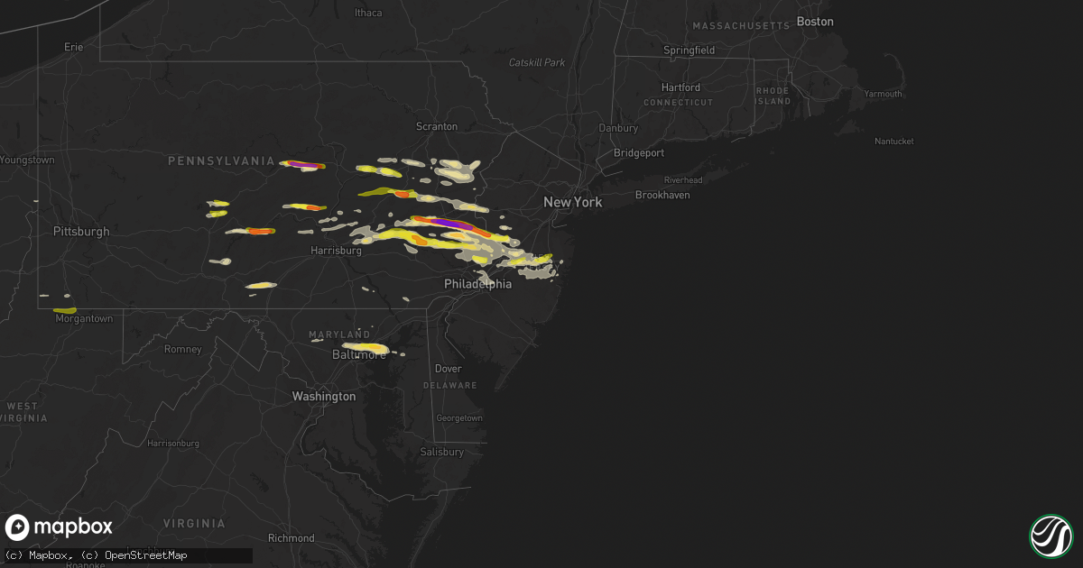
Hail Map in New Jersey on May 29, 2019
Get this storm
May 29 map
$229
one time, instant access
Download today. No call, no setup
Keep the $229
Bought the map and want the full workflow? Apply the entire $229 to a subscription within 7 days. None of it is wasted.
Every map, not just this one
This buys you this map. Subscription and you get every map we run, in the markets you choose from a few cities to whole states to nationwide. Plus real-time alerts the moment a storm fires.
Contact data
Name, contact info, occupancy, even credit band for addresses in the footprint. You go from where it hit to who to call.
Become the source they trust
Unlimited branding weather history reports on demand. You already have the documented answer ready for the property owner, and you are the one who showed up with it.
Property data and RoofTrace estimates
Pull up any address you have got, its value and the exact code rules for that jurisdiction, straight from One Click Code. Then RoofTrace estimates the squares, pitch, and roof value, priced the way you price.
Storm reports in New Jersey
New Jersey
| Date | Description |
|---|---|
| 05/29/20196:35 PM CDT | A few tees down... Including one downed into wires at the intersection of evergreen and spring garden. Time estimated from radar. |
| 05/29/20194:44 PM CDT | Downed utility pole and wires on nj-27 in both directions at cr 571 and washington st. All lanes closed. |
| 05/29/20194:33 PM CDT | Wires/tree down on the roads. |
| 05/29/20194:30 PM CDT | Downed tree and wires on nj-31 in both directions north of cr-612. All lanes closed. Time estimated from radar. |
| 05/29/20194:21 PM CDT | Delayed report. Several trees down on cedar lake road. Time estimated from radar. |
| 05/29/20194:15 PM CDT | A local report indicates 1.00 inch wind near 2 S FREEHOLD TWP |
| 05/29/20193:42 PM CDT | A local report indicates 1.25 inch wind near YARDVILLE |
| 05/29/20193:37 PM CDT | Delayed report of several trees down in harmony twp. Time estimated from radar. |
| 05/29/20193:37 PM CDT | Delayed report. Downed tree on manunka chunk road near u.s. Highway 46. Time estimated from radar. |
| 05/29/20193:21 PM CDT | Corrects previous tstm wnd dmg report from 2 ssw blairstown. Delayed report. Several trees down on cedar lake road. Time estimated from radar. |
| 05/29/20193:20 PM CDT | A local report indicates 1.00 inch wind near HOPEWELL |
| 05/29/20193:20 PM CDT | A local report indicates 1.50 inch wind near EAST AMWELL |
| 05/29/20193:15 PM CDT | Delayed report. Extensive tree damage on route 611 in delaware water gap national recreation area. The road was closed for several hours. Time estimated from radar. |
| 05/29/20192:58 PM CDT | A local report indicates 1.75 inch wind near LUMBERVILLE |
| 05/29/20192:33 AM CDT | At 732 PM EDT, severe thunderstorms were located along a line extending from near Hammonton to near Big Stone Beach, moving east at 50 mph. HAZARD...60 mph wind gusts and quarter size hail. SOURCE...Radar indicated. IMPACT...Minor damage to vehicles is possible. Wind damage to roofs, siding, trees, and power lines is possible. Locations impacted include... Vineland, Atlantic City, Millville, Ocean City, Cumberland, Pleasantville, Hammonton, Somers Point, Ventnor City, Brigantine, Northfield, Absecon, Egg Harbor City, North Wildwood, Laurel Lake, Tuckerton, Wildwood Crest, Weymouth, Woodbine and Sea Isle City. |
| 05/29/20192:08 AM CDT | At 707 PM EDT, a severe thunderstorm was located over Woodstown, or 13 miles east of Wilmington, moving east at 45 mph. HAZARD...60 mph wind gusts. SOURCE...Radar indicated. IMPACT...Damage to roofs, siding, trees, and power lines is possible. Locations impacted include... Vineland, Millville, Glassboro, Hammonton, Pennsville, Pitman, Clayton, Salem, Buena, Egg Harbor City, Woodstown, Alloway, Weymouth, Swedesboro, Estell Manor, Newfield, Elmer, Franklinville, Sicklerville and Elwood-Magnolia. |
| 05/29/201912:49 AM CDT | At 548 PM EDT, a severe thunderstorm was located over Churchtown, or 8 miles east of New Holland, moving east at 55 mph. HAZARD...60 mph wind gusts and quarter size hail. SOURCE...Radar indicated. IMPACT...Minor damage to vehicles is possible. Wind damage to roofs, siding, trees, and power lines is possible. Locations impacted include... Philadelphia, West Chester, Norristown, Chester, Pottstown, Phoenixville, West Norriton, East Norriton, Coatesville, Yeadon, Westtown, Downingtown, Conshohocken, Hatboro, Folcroft, Ambler, Swarthmore, Kennett Square, Collegeville and Royersford. |
| 05/28/201911:37 PM CDT | At 437 PM EDT, a severe thunderstorm was located over Princeton Meadows, or 12 miles northeast of Trenton, moving east at 35 mph. HAZARD...60 mph wind gusts and quarter size hail. SOURCE...Radar indicated. IMPACT...Minor damage to vehicles is possible. Wind damage to roofs, siding, trees, and power lines is possible. Locations impacted include... Toms River, New Brunswick, Sandy Hook, Lakewood, Middletown, Old Bridge, Jackson, Howell, East Brunswick, South Brunswick, Sayreville, North Brunswick, Marlboro, Manalapan, Tinton Falls, Holmdel, Princeton, Red Bank, Keansburg and Matawan. |
| 05/28/201911:18 PM CDT | At 417 PM EDT, a severe thunderstorm was located over Laureldale, or near Reading, moving east at 40 mph. HAZARD...70 mph wind gusts and ping pong ball size hail. SOURCE...Radar indicated. IMPACT...People and animals outdoors will be injured. Expect hail damage to roofs, siding, windows, and vehicles. Expect considerable tree damage. Wind damage is also likely to mobile homes, roofs, and outbuildings. Locations impacted include... Allentown, Bethlehem, Pottstown, Lansdale, East Norriton, Emmaus, Quakertown, Perkasie, Doylestown, Souderton, Bedminster, Ambler, Hellertown, Collegeville, Royersford, Chalfont, Trappe, Hatfield, East Greenville and Dublin. |
| 05/28/201911:04 PM CDT | At 404 PM EDT, a severe thunderstorm was located over New Hope, or 13 miles northwest of Trenton, moving east at 35 mph. HAZARD...60 mph wind gusts and quarter size hail. SOURCE...Radar indicated. IMPACT...Minor damage to vehicles is possible. Wind damage to roofs, siding, trees, and power lines is possible. Locations impacted include... Trenton, East Brunswick, South Brunswick, Ewing, Princeton, Hightstown, Cranbury, Pennington, New Hope, Yardley, Hopewell, Allentown, Roosevelt, Rocky Hill, Stockton, Washington Crossing, Skillman, Windsor, Princeton Meadows and Kingston. |
| 05/28/201910:10 PM CDT | At 310 PM EDT, a severe thunderstorm was located over Emmaus, or near Allentown, moving east at 35 mph. HAZARD...70 mph wind gusts and ping pong ball size hail. SOURCE...Radar indicated. IMPACT...People and animals outdoors will be injured. Expect hail damage to roofs, siding, windows, and vehicles. Expect considerable tree damage. Wind damage is also likely to mobile homes, roofs, and outbuildings. Locations impacted include... Bethlehem, Quakertown, Perkasie, Doylestown, Byram, Souderton, Bedminster, Hellertown, Flemington, Chalfont, Tinicum, Clinton, New Hope, Dublin, Ferndale, Frenchtown, Lebanon, Milford, Riegelsville and Stockton. |
All States Impacted by Hail Map on May 29, 2019
Cities Impacted by Hail Map on May 29, 2019
- Seth, WV
- Danville, WV
- Madison, WV
- Ada, OK
- Trent, TX
- Sweetwater, TX
- Merkel, TX
- Hawley, TX
- Abilene, TX
- Germansville, PA
- Lehighton, PA
- Andreas, PA
- Horsham, PA
- Huntingdon Valley, PA
- Ambler, PA
- Hatboro, PA
- Willow Grove, PA
- Dresher, PA
- Perrin, TX
- Weatherford, TX
- Graford, TX
- Mineral Wells, TX
- Waverly, KY
- Morganfield, KY
- Clinton, AR
- Stroudsburg, PA
- Long Pond, PA
- Pocono Lake, PA
- Blakeslee, PA
- Hardy, AR
- Cherokee Village, AR
- Ash Flat, AR
- Okmulgee, OK
- Princeton, NJ
- Ezel, KY
- West Liberty, KY
- Lexington, VA
- Glasgow, VA
- Natural Bridge, VA
- Nathalie, VA
- Doylestown, PA
- Pipersville, PA
- Lumberville, PA
- New Hope, PA
- Hulbert, OK
- Sumner, IA
- Fredericksburg, IA
- Waverly, IA
- Tripoli, IA
- Wilsondale, WV
- Chapmanville, WV
- Dingess, WV
- Harts, WV
- Breeden, WV
- Tulsa, OK
- Broken Arrow, OK
- Macungie, PA
- Zionsville, PA
- Breinigsville, PA
- Kutztown, PA
- Emmaus, PA
- Mertztown, PA
- Quakertown, PA
- Richlandtown, PA
- Coopersburg, PA
- Alburtis, PA
- Topton, PA
- Trenton, NJ
- Crofton, KY
- Carversville, PA
- Perkasie, PA
- Ottsville, PA
- Breckenridge, TX
- Caddo, TX
- Azle, TX
- Springtown, TX
- Haskell, OK
- Seco, KY
- Haysi, VA
- Vansant, VA
- McRoberts, KY
- Grundy, VA
- Neon, KY
- Shelby Gap, KY
- Jackhorn, KY
- Jenkins, KY
- Clintwood, VA
- Whitesburg, KY
- Pound, VA
- Millstone, KY
- Clinchco, VA
- Ellington, MO
- Piedmont, MO
- Drasco, AR
- Concord, AR
- Mountain View, AR
- Higden, AR
- Prim, AR
- Princeton, KY
- Cerulean, KY
- Ozona, TX
- Bland, MO
- Belle, MO
- Russellville, KY
- Morgantown, KY
- Lewisburg, KY
- Bowling Green, KY
- Rockfield, KY
- Gretna, VA
- Hurt, VA
- Long Island, VA
- Kansas, IL
- Casey, IL
- Westfield, IL
- Martinsville, IL
- Ashmore, IL
- Postville, IA
- Coahoma, TX
- Big Spring, TX
- Siloam Springs, AR
- Gentry, AR
- Palmerton, PA
- Flat Top, WV
- Jumping Branch, WV
- De Queen, AR
- Roscoe, TX
- Loraine, TX
- Colorado City, TX
- Ennis, TX
- Cairo, IL
- Charleston, MO
- Albany, TX
- Blossom, TX
- Detroit, TX
- Paris, TX
- Goldsmith, TX
- Woodson, TX
- Throckmorton, TX
- Bangor, PA
- Hopewell, NJ
- Lambertville, NJ
- Pennington, NJ
- Myerstown, PA
- Gilbertsville, PA
- Boyertown, PA
- Perkiomenville, PA
- Zieglerville, PA
- Birdsboro, PA
- Douglassville, PA
- Oley, PA
- Womelsdorf, PA
- Temple, PA
- Telford, PA
- Leesport, PA
- Mohrsville, PA
- Robesonia, PA
- Reading, PA
- Schwenksville, PA
- Pottstown, PA
- Frederick, PA
- Richland, PA
- Bernville, PA
- Green Lane, PA
- Wernersville, PA
- Harleysville, PA
- Powersite, MO
- Kirbyville, MO
- Branson, MO
- Forsyth, MO
- Hollister, MO
- Kresgeville, PA
- Kunkletown, PA
- Blue Creek, OH
- Lynx, OH
- West Union, OH
- Stout, OH
- Annapolis, MO
- Fredericktown, MO
- Narrows, VA
- Warminster, PA
- Southampton, PA
- Six Mile Run, PA
- Hopewell, PA
- Gunter, TX
- Pilot Point, TX
- Tipton, IA
- Bennett, IA
- Clarence, IA
- Bloomsburg, PA
- Sugarloaf, PA
- Nescopeck, PA
- Rock Glen, PA
- Hume, IL
- Metcalf, IL
- Chrisman, IL
- Brocton, IL
- Patriot, OH
- Crown City, OH
- Cleveland, AR
- Scotland, AR
- Leonard, TX
- Dodd City, TX
- Honey Grove, TX
- Windom, TX
- Wolfe City, TX
- Ladonia, TX
- Bonham, TX
- Brackettville, TX
- Annville, PA
- Lebanon, PA
- North Henderson, IL
- Rio, IL
- Houston, AR
- Cisco, TX
- Richfield, PA
- McAlisterville, PA
- Cocolamus, PA
- Millerstown, PA
- McClure, PA
- Monona, IA
- Tuscarora, PA
- Barnesville, PA
- Tamaqua, PA
- Brockton, PA
- Nimitz, WV
- Hinton, WV
- Bentonville, AR
- Springdale, AR
- Alvaton, KY
- Saylorsburg, PA
- Effort, PA
- Brodheadsville, PA
- Lake Harmony, PA
- Sciota, PA
- Jim Thorpe, PA
- Albrightsville, PA
- Mount Vernon, IN
- Corning, AR
- Knobel, AR
- Delaplaine, AR
- Paragould, AR
- Peach Orchard, AR
- Oak Hill, OH
- Beaver, OH
- South Webster, OH
- Minford, OH
- Jackson, OH
- Lucasville, OH
- Java, VA
- Mary D, PA
- Knott, TX
- Stanton, TX
- Bergheim, TX
- Spring Branch, TX
- Kendalia, TX
- Fancy Farm, KY
- Tioga, TX
- Celina, TX
- Collinsville, TX
- Mansfield, TX
- Kennedale, TX
- Arlington, TX
- Del Rio, TX
- Graham, TX
- Grand Saline, TX
- Mulberry Grove, IL
- Paris, IL
- Manchester, KY
- Swisher, IA
- Rebersburg, PA
- Loganton, PA
- Mifflinburg, PA
- Mill Hall, PA
- Proctor, OK
- Tahlequah, OK
- Burlington, IA
- Milford, VA
- Harrison, AR
- Omaha, AR
- Porter, OK
- Carthage, IL
- Mineola, TX
- Jackson, MO
- Kemp, TX
- Stanwood, IA
- Mechanicsville, IA
- Oxford Junction, IA
- Lost Nation, IA
- Lowden, IA
- Wheatland, IA
- Moran, TX
- Patterson, MO
- Hot Springs National Park, AR
- Kissee Mills, MO
- Blue Eye, MO
- Lampe, MO
- Reeds Spring, MO
- Gardendale, TX
- Odessa, TX
- Midland, TX
- Ozark, AR
- West Branch, IA
- Iowa City, IA
- Pursglove, WV
- Morgantown, WV
- Blacksville, WV
- Wana, WV
- Maidsville, WV
- Fairview, WV
- Burton, WV
- Pittsfield, IL
- Hermleigh, TX
- Hamburg, PA
- Lenhartsville, PA
- Shoemakersville, PA
- Bowen, IL
- La Prairie, IL
- Augusta, IL
- Vichy, MO
- Saint Louis, MO
- Big Rock, VA
- Hurley, VA
- Gillham, AR
- McVeytown, PA
- Mount Union, PA
- Mapleton Depot, PA
- Mill Creek, PA
- Middle River, MD
- Gunpowder, MD
- Rosedale, MD
- Essex, MD
- Towson, MD
- White Marsh, MD
- Randallstown, MD
- Perry Hall, MD
- Pikesville, MD
- Nottingham, MD
- Parkville, MD
- Gwynn Oak, MD
- Baltimore, MD
- Windsor Mill, MD
- Teutopolis, IL
- Altamont, IL
- Shumway, IL
- Effingham, IL
- Sigel, IL
- Watson, IL
- Wheeler, IL
- Sparks, OK
- Meeker, OK
- Bethany, IL
- Sullivan, IL
- Cape Charles, VA
- Inez, KY
- Tomahawk, KY
- Pilgrim, KY
- Debord, KY
- Elkton, KY
- Greenville, KY
- Shawnee, OK
- Tecumseh, OK
- Hopkinsville, KY
- Danville, PA
- Salyersville, KY
- Thompsontown, PA
- Mifflintown, PA
- Eureka Springs, AR
- Northampton, PA
- New Tripoli, PA
- Laurys Station, PA
- Gilberton, PA
- Hellertown, PA
- Slatedale, PA
- Bethlehem, PA
- Bath, PA
- Coplay, PA
- Asbury, NJ
- Walnutport, PA
- Allentown, PA
- Phillipsburg, NJ
- Shenandoah, PA
- Milford, NJ
- New Ringgold, PA
- Stewartsville, NJ
- Mahanoy City, PA
- New Philadelphia, PA
- Slatington, PA
- Mahanoy Plane, PA
- Bloomsbury, NJ
- Easton, PA
- Nazareth, PA
- Phoenix, MD
- Taft, OK
- Colcord, OK
- Wagoner, OK
- Westville, OK
- Okemah, OK
- Coweta, OK
- Muskogee, OK
- Henryetta, OK
- Wetumka, OK
- Boley, OK
- Kansas, OK
- Bristow, OK
- Watts, OK
- Castle, OK
- Morris, OK
- Fort Gibson, OK
- Weleetka, OK
- Hardeeville, SC
- Sonora, TX
- Flemington, NJ
- Ringoes, NJ
- Annapolis, IL
- Goldfield, IA
- Renwick, IA
- Chesterfield, MO
- Cobden, IL
- Holdenville, OK
- Edgewood, TX
- Fruitvale, TX
- Canton, TX
- Mabank, TX
- Alba, TX
- Wills Point, TX
- Checotah, OK
- Eufaula, OK
- Richland Center, WI
- Aledo, IL
- Reynolds, IL
- Carman, IL
- Claremore, OK
- Catoosa, OK
- Owasso, OK
- Rhome, TX
- Eldorado, TX
- White Plains, KY
- Pea Ridge, AR
- Rogers, AR
- Saltville, VA
- Saint Joe, AR
- Marshall, AR
- New Richmond, OH
- California, KY
- Winnsboro, TX
- Hardy, IA
- Humboldt, IA
- Healdton, OK
- Westbrook, TX
- Elgin, IA
- East Stroudsburg, PA
- Hazel Green, KY
- Campton, KY
- Des Arc, MO
- Fort Worth, TX
- Keller, TX
- Ely, IA
- Cedar Rapids, IA
- Solon, IA
- Herndon, WV
- Matoaka, WV
- Lashmeet, WV
- Oblong, IL
- Yale, IL
- Gallipolis, OH
- New Egypt, NJ
- Lakehurst, NJ
- Prue, OK
- Mount Judea, AR
- Dunmor, KY
- Benton, AR
- Santo, TX
- Palo Pinto, TX
- Altoona, PA
- Tyrone, PA
- Stuart, VA
- Bassett, VA
- Henry, VA
- Ferrum, VA
- Richmond, KY
- Poolville, TX
- North Richland Hills, TX
- Southlake, TX
- Scranton, AR
- Bastrop, TX
- Independence, VA
- Fries, VA
- Cripple Creek, VA
- Ivanhoe, VA
- Bridgeton, MO
- Saint Charles, MO
- Earth City, MO
- Maryland Heights, MO
- Guthrie, KY
- Telephone, TX
- Ocotillo, CA
- Julian, WV
- Foster, WV
- Peytona, WV
- Ridgeview, WV
- Costa, WV
- Ryan, OK
- Ringling, OK
- Ewing, MO
- Durham, MO
- Maywood, MO
- Philadelphia, MO
- Hidalgo, IL
- Penelope, TX
- Science Hill, KY
- Somerset, KY
- Bowling Green, MO
- Louisiana, MO
- Partridge, KY
- Paden, OK
- Larue, TX
- Athens, TX
- Eddyville, KY
- Quitman, TX
- Olin, IA
- Belton, KY
- Lavaca, AR
- Fort Smith, AR
- Cooper, TX
- Davis, OK
- Wynnewood, OK
- Pikeville, KY
- Oneida, KY
- Baird, TX
- Mount Vernon, IA
- Lexington, OK
- Eldred, IL
- Carrollton, IL
- Saint Peters, MO
- O'Fallon, MO
- Pennsburg, PA
- Thayer, MO
- Wanette, OK
- Jacksboro, TX
- Bryson, TX
- Fieldon, IL
- Appalachia, VA
- Deer, AR
- Hagarville, AR
- Clarksville, AR
- Ozone, AR
- Galax, VA
- Woodlawn, VA
- Fairbanks, IN
- Edgemont, AR
- Cumberland, VA
- Pleasant Hill, IL
- Basco, IL
- Piasa, IL
- Shipman, IL
- Medora, IL
- Mount Olive, IL
- Nortonville, KY
- Saint Charles, KY
- Center Ridge, AR
- Springfield, AR
- Kaufman, TX
- Aledo, TX
- Prestonsburg, KY
- Van Lear, KY
- East Point, KY
- Hagerhill, KY
- Auxier, KY
- Davy, WV
- Washington Crossing, PA
- Morrisville, PA
- Essex, MO
- Wilson, OK
- Eustace, TX
- Lansdale, PA
- Line Lexington, PA
- Hilltown, PA
- Hatfield, PA
- Colmar, PA
- Chalfont, PA
- Liberty, KY
- Defiance, MO
- Crowley, TX
- Bedford, TX
- Colleyville, TX
- Hurst, TX
- Haltom City, TX
- Naval Air Station Jrb, TX
- Roanoke, TX
- Euless, TX
- Haslet, TX
- Heber Springs, AR
- Lewes, DE
- Fredericksburg, PA
- Bethel, PA
- Bixby, OK
- Beggs, OK
- Mounds, OK
- Auburn, KY
- Locust Grove, AR
- Richardson, TX
- Dallas, TX
- Fort Loudon, PA
- Mercersburg, PA
- Saint Thomas, PA
- Chambersburg, PA
- Titusville, NJ
- Stockton, NJ
- Worton, MD
- Montrose, IL
- Lewistown, PA
- Mount Pleasant Mills, PA
- Saint Ann, MO
- Forest Hill, MD
- Fallston, MD
- Crewe, VA
- Jackson, KY
- Jonestown, PA
- Beeson, WV
- Rock, WV
- Locust Grove, OK
- Chandler, OK
- Woodburn, KY
- Speedwell, VA
- Wytheville, VA
- Bigelow, AR
- Perryville, AR
- Morrilton, AR
- Perry, AR
- Frenchburg, KY
- Salt Lick, KY
- Wingo, KY
- Nilwood, IL
- Carlinville, IL
- Franklin, AR
- Rush Springs, OK
- Saxton, PA
- Newport, PA
- New Bloomfield, PA
- Elliottsburg, PA
- Nashville, IN
- Columbus, IN
- Robbinsville, NJ
- Princeton Junction, NJ
- Lawrence Township, NJ
- Poplar Bluff, MO
- Jackson, NJ
- Freehold, NJ
- Silverdale, PA
- Fountainville, PA
- Newtown, PA
- Bechtelsville, PA
- Warrington, PA
- Dublin, PA
- Souderton, PA
- Red Hill, PA
- Point Pleasant, PA
- Furlong, PA
- Sellersville, PA
- Trumbauersville, PA
- Richboro, PA
- Fleetwood, PA
- Jamison, PA
- East Greenville, PA
- Strawn, TX
- California, MO
- Wind Ridge, PA
- Aleppo, PA
- Holbrook, PA
- Searcy, AR
- Romance, AR
- Henrietta, TX
- Belfry, KY
- Sidney, KY
- Litchfield, IL
- Alma, AR
- Mulberry, AR
- Luana, IA
- Clermont, IA
- Shirley, AR
- Sikeston, MO
- Scotrun, PA
- Tannersville, PA
- Pocono Pines, PA
- Livermore, KY
- Windsor, PA
- Red Lion, PA
- Brogue, PA
- Felton, PA
- Wharton, WV
- Sumner, TX
- Brookston, TX
- Witts Springs, AR
- Bourbon, MO
- Miami, OK
- Dalton City, IL
- Macon, IL
- Findlay, IL
- Moweaqua, IL
- Fayetteville, AR
- Gravelly, AR
- Harvey, AR
- West York, IL
- Greenup, IL
- West Union, IL
- Kuttawa, KY
- Grand Rivers, KY
- Imboden, AR
- Black Rock, AR
- Owingsville, KY
- Gideon, MO
- Portageville, MO
- Saint Francis, KY
- Loretto, KY
- Allen, KY
- Langley, KY
- Martin, KY
- David, KY
- Gunlock, KY
- Hueysville, KY
- Printer, KY
- Hegins, PA
- Sacramento, PA
- Spring Glen, PA
- Blue Mound, IL
- Savoy, TX
- Oxford, IA
- Amana, IA
- Utica, KY
- Hartford, KY
- Goodview, VA
- Vinton, VA
- Moneta, VA
- Chaffee, MO
- Henderson, KY
- Reedy, WV
- Elkfork, KY
- Farmville, VA
- Sand Springs, OK
- Cleveland, OK
- Cedar Bluff, VA
- Hillsborough, NJ
- Dolph, AR
- Elizabeth, AR
- Bexar, AR
- Viola, AR
- Shell Rock, IA
- Paint Lick, KY
- Berea, KY
- Clyde, TX
- Heltonville, IN
- Bedford, IN
- Penhook, VA
- Martinsville, VA
- Rocky Mount, VA
- Sapulpa, OK
- Kellyville, OK
- Kiefer, OK
- Olmstead, KY
- Allensville, KY
- West Point, IL
- Loraine, IL
- Charleston, IL
- Talala, OK
- Oxford, PA
- Kirkwood, PA
- Solgohachia, AR
- Ravenna, TX
- Ivanhoe, TX
- Brownsboro, TX
- Murchison, TX
- Centerton, AR
- Boerne, TX
- Vinton, OH
- Thurman, OH
- Rio Grande, OH
- Gallipolis Ferry, WV
- Bidwell, OH
- Fallentimber, PA
- Blandburg, PA
- Hickman, KY
- Marston, MO
- Lilbourn, MO
- Winchester, OH
- Seaman, OH
- Geff, IL
- Chesterfield, NJ
- Gwynedd, PA
- Bordentown, NJ
- Bensalem, PA
- Palmyra, PA
- Barto, PA
- Fort Washington, PA
- Roebling, NJ
- Collegeville, PA
- Blue Bell, PA
- Hershey, PA
- Bryn Athyn, PA
- Fairless Hills, PA
- Hummelstown, PA
- Feasterville Trevose, PA
- Norristown, PA
- Skippack, PA
- Jenkintown, PA
- Bally, PA
- Bristol, PA
- Langhorne, PA
- Windsor, NJ
- Ono, PA
- Florence, NJ
- Harrisburg, PA
- Burlington, NJ
- Columbus, NJ
- Grantville, PA
- Shartlesville, PA
- North Wales, PA
- Allentown, NJ
- Philadelphia, PA
- Roosevelt, NJ
- Abington, PA
- Hightstown, NJ
- Montgomeryville, PA
- Millstone Township, NJ
- Levittown, PA
- Palm, PA
- Howell, NJ
- Spring House, PA
- Cream Ridge, NJ
- Nancy, KY
- Windsor, KY
- Bethelridge, KY
- Eubank, KY
- New Douglas, IL
- Alhambra, IL
- Shelbiana, KY
- Raccoon, KY
- Phyllis, KY
- Subiaco, AR
- Petty, TX
- La Grange, MO
- London, TX
- McConnellsburg, PA
- Howe, TX
- Temple, TX
- Tresckow, PA
- Junedale, PA
- Hazleton, PA
- Wewoka, OK
- Latham, MO
- Pomeroy, OH
- Rutland, OH
- Racine, OH
- Middleport, OH
- Beaver, WV
- Daniels, WV
- Drums, PA
- Wapwallopen, PA
- Mountain Top, PA
- Ranger, TX
- Delmar, IA
- Lisbon, IA
- Saint Elmo, IL
- Story, AR
- White Haven, PA
- Freeland, PA
- Seaton, IL
- Oquawka, IL
- Rousseau, KY
- Bradfordsville, KY
- Elk Horn, KY
- Floral, AR
- Malakoff, TX
- Pennsauken, NJ
- Elkins Park, PA
- Camden, NJ
- Palmyra, NJ
- Cherry Hill, NJ
- Riverton, NJ
- Merchantville, NJ
- Moorestown, NJ
- Cheltenham, PA
- Maple Shade, NJ
- Liverpool, PA
- Millersburg, PA
- Maud, OK
- Asher, OK
- Arthur City, TX
- Hardy, VA
- Prague, OK
- Harrah, OK
- Mcloud, OK
- Marengo, IA
- Homestead, IA
- South Amana, IA
- North Liberty, IA
- Fairfax, IA
- Berwick, PA
- Orangeville, PA
- Ravenden, AR
- Norton, VA
- Cape Girardeau, MO
- Berryville, AR
- Taneyville, MO
- Mouthcard, KY
- Steele, KY
- Cookstown, NJ
- Lakewood, NJ
- Joint Base Mdl, NJ
- Wrightstown, NJ
- Jobstown, NJ
- Manchester Township, NJ
- Toms River, NJ
- Bee Branch, AR
- Quitman, AR
- Ben Wheeler, TX
- Welling, OK
- Earlsboro, OK
- Booneville, KY
- Dalmatia, PA
- Elizabethville, PA
- Berrysburg, PA
- Vincennes, IN
- Robards, KY
- Corydon, KY
- Horseshoe Bend, AR
- Newalla, OK
- Pauls Valley, OK
- New Hartford, IA
- Philpot, KY
- Melvin, KY
- Bypro, KY
- Bevinsville, KY
- Beaver, KY
- Weeksbury, KY
- Virgie, KY
- Wheelwright, KY
- Robinson Creek, KY
- Pawnee, OK
- Maramec, OK
- Hominy, OK
- Amherstdale, WV
- Naoma, WV
- Pineville, WV
- Evansville, IN
- Sharon Grove, KY
- Pembroke, KY
- Trenton, KY
- Purdon, TX
- Trenton, TX
- Winters, TX
- Marcella, AR
- Batesville, AR
- Beecher City, IL
- Bell City, MO
- Tumbling Shoals, AR
- Paoli, OK
- Saint Olaf, IA
- Marion, VA
- Meadowview, VA
- Lincoln, AR
- Stratford, OK
- Couch, MO
- Owensboro, KY
- Fredonia, KY
- Theodosia, MO
- Hodgen, OK
- Hesston, PA
- Williamsburg, PA
- Huntingdon, PA
- Loysburg, PA
- New Enterprise, PA
- Woodbury, PA
- Spencer, WV
- Bryant, AR
- Summersville, WV
- Calhoun, KY
- Wadesville, IN
- Winona, MO
- Cadiz, KY
- Gracey, KY
- East Liverpool, OH
- Barlow, KY
- Woolwine, VA
- Dyess Afb, TX
- Tye, TX
- Mingus, TX
- Gordon, TX
- Atoka, OK
- Irving, TX
- Carrollton, TX
- Clarksville, MO
- Carrollton, OH
- Campbellsville, KY
- Mount Pleasant, AR
- Hennepin, OK
- Duncannon, PA
- Halifax, PA
- Amelia Court House, VA
- Greenville, TX
- Damascus, AR
- Emden, MO
- Monroe City, MO
- Trinidad, TX
- Saint Albans, MO
- Wildwood, MO
- Ballwin, MO
- Pacific, MO
- Mayfield, KY
- Gainesville, MO
- Sebree, KY
- Mifflinville, PA
- Zion Grove, PA
- Owensville, MO
- Terrell, TX
- Divernon, IL
- Virden, IL
- Grethel, KY
- Harold, KY
- Chilhowie, VA
- Glade Spring, VA
- Lebanon, VA
- Abingdon, VA
- Glenpool, OK
- Springer, OK
- Macomb, OK
- Protem, MO
- McLeansboro, IL
- Lake Creek, TX
- Rosebud, TX
- Auburn, PA
- Schuylkill Haven, PA
- La Center, KY
- Kevil, KY
- Pineville, AR
- Hawkeye, IA
- West Union, IA
- Fayette, IA
- Golden, MO
- Cassville, MO
- Orbisonia, PA
- Dysart, PA
- Bellwood, PA
- McClure, VA
- Eolia, KY
- Oakwood, VA
- Milford, DE
- Rockport, IL
- Dille, WV
- Clay, WV
- Krum, TX
- Decatur, TX
- Ponder, TX
- Mohnton, PA
- Weatherly, PA
- Lebanon, NJ
- East Prairie, MO
- Beech Grove, AR
- Rhodell, WV
- Odd, WV
- Josephine, WV
- Waterville, IA
- Harpers Ferry, IA
- Waynesburg, PA
- Athens, WV
- Lerona, WV
- Princeton, WV
- Atkins, VA
- Chatham, IL
- Prairie Grove, AR
- Stroud, OK
- Woodbine, MD
- Sykesville, MD
- Mount Airy, MD
- Peebles, OH
- Otway, OH
- Chatfield, TX
- Plymouth, IL
- West Liberty, IL
- Byars, OK
- Isom, KY
- Jeremiah, KY
- Premium, KY
- Brookneal, VA
- Lafe, AR
- Fredericksburg, TX
- Mount Vernon, KY
- McKee, KY
- Orlando, KY
- Dawson Springs, KY
- Hanna, OK
- Dustin, OK
- Cyclone, WV
- Wayland, KY
- Flower Mound, TX
- Oran, MO
- Harviell, MO
- Neelyville, MO
- Fairfield Bay, AR
- Eagletown, OK
- Richland, TX
- Thermal, CA
- Farmingdale, NJ
- Brick, NJ
- Heavener, OK
- Bragg City, MO
- Wardell, MO
- Beech Creek, PA
- Blanchard, PA
- Jerseyville, IL
- Fidelity, IL
- Eastman, WI
- Fountaintown, IN
- Fort Towson, OK
- Enloe, TX
- Roxton, TX
- Klondike, TX
- Coeburn, VA
- Nora, VA
- Bartonsville, PA
- Corsicana, TX
- Beach City, OH
- Alexander, AR
- Millsap, TX
- Whitt, TX
- Pen Argyl, PA
- Gilbert, PA
- Mendon, IL
- Griggsville, IL
- Greenwood, AR
- Lamar, OK
- Brooklyn, MD
- Means, KY
- Olympia, KY
- Camp Creek, WV
- Spanishburg, WV
- Newark, TX
- Kimberling City, MO
- Lewisburg, PA
- Trexlertown, PA
- Center Valley, PA
- Kintnersville, PA
- Frackville, PA
- Locust Gap, PA
- Mount Carmel, PA
- Coal Township, PA
- Ringtown, PA
- Kulpmont, PA
- Girardville, PA
- Ashland, PA
- Shamokin, PA
- Wilburton, PA
- Honey Grove, PA
- East Waterford, PA
- Catawissa, PA


