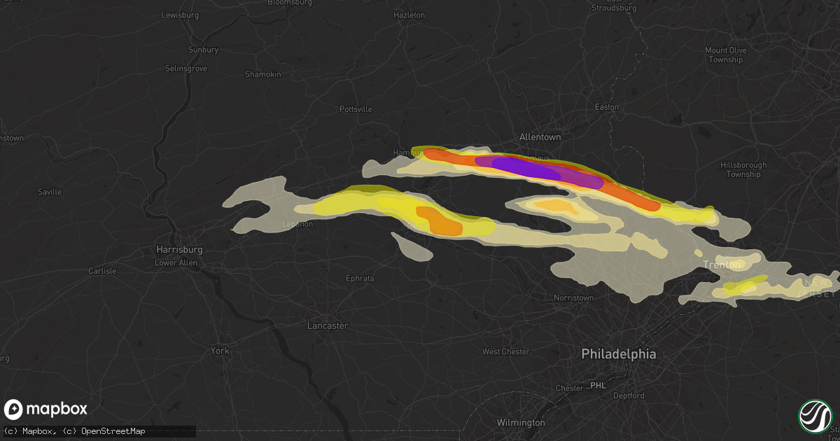
Hail Map in Reading, PA on May 29, 2019
Get this storm
May 29 map
$229
one time, instant access
Download today. No call, no setup
Keep the $229
Bought the map and want the full workflow? Apply the entire $229 to a subscription within 7 days. None of it is wasted.
Every map, not just this one
This buys you this map. Subscription and you get every map we run, in the markets you choose from a few cities to whole states to nationwide. Plus real-time alerts the moment a storm fires.
Contact data
Name, contact info, occupancy, even credit band for addresses in the footprint. You go from where it hit to who to call.
Become the source they trust
Unlimited branding weather history reports on demand. You already have the documented answer ready for the property owner, and you are the one who showed up with it.
Property data and RoofTrace estimates
Pull up any address you have got, its value and the exact code rules for that jurisdiction, straight from One Click Code. Then RoofTrace estimates the squares, pitch, and roof value, priced the way you price.
Storm reports in Reading, PA
Reading, PA
| Date | Description |
|---|---|
| 05/29/20194:24 PM CDT | Delayed report of trees down on museum road between lancaster avenue and old mill road. Time estimated from radar. |
| 05/29/20194:19 PM CDT | Delayed report of tree and wires down on river road in muhlenberg twp. Time estimated from radar. |
| 05/29/20193:30 PM CDT | Multiple large trees snapped or uprooted. Public report relayed by emergency management. Time estimated. |
| 05/29/20193:26 PM CDT | Time estimated from radar. |
| 05/29/20193:23 PM CDT | Delayed report of trees and wires down near the intersection of 23rd street and cumberland avenue. Time estimated from radar. |
| 05/29/20193:23 PM CDT | Delayed report of tree down on friedensburg road in lower alsace twp. Time estimated from radar. |
| 05/29/20193:18 PM CDT | Several reports of hail up to quarter size in laureldale and muhlenberg twp. Time estimated from radar. |
All States Impacted by Hail Map on May 29, 2019
All Cities Impacted by Hail Map on May 29, 2019
- Seth, WV
- Danville, WV
- Madison, WV
- Ada, OK
- Trent, TX
- Sweetwater, TX
- Merkel, TX
- Hawley, TX
- Abilene, TX
- Germansville, PA
- Lehighton, PA
- Andreas, PA
- Horsham, PA
- Huntingdon Valley, PA
- Ambler, PA
- Hatboro, PA
- Willow Grove, PA
- Dresher, PA
- Perrin, TX
- Weatherford, TX
- Graford, TX
- Mineral Wells, TX
- Waverly, KY
- Morganfield, KY
- Clinton, AR
- Stroudsburg, PA
- Long Pond, PA
- Pocono Lake, PA
- Blakeslee, PA
- Hardy, AR
- Cherokee Village, AR
- Ash Flat, AR
- Okmulgee, OK
- Princeton, NJ
- Ezel, KY
- West Liberty, KY
- Lexington, VA
- Glasgow, VA
- Natural Bridge, VA
- Nathalie, VA
- Doylestown, PA
- Pipersville, PA
- Lumberville, PA
- New Hope, PA
- Hulbert, OK
- Sumner, IA
- Fredericksburg, IA
- Waverly, IA
- Tripoli, IA
- Wilsondale, WV
- Chapmanville, WV
- Dingess, WV
- Harts, WV
- Breeden, WV
- Tulsa, OK
- Broken Arrow, OK
- Macungie, PA
- Zionsville, PA
- Breinigsville, PA
- Kutztown, PA
- Emmaus, PA
- Mertztown, PA
- Quakertown, PA
- Richlandtown, PA
- Coopersburg, PA
- Alburtis, PA
- Topton, PA
- Trenton, NJ
- Crofton, KY
- Carversville, PA
- Perkasie, PA
- Ottsville, PA
- Breckenridge, TX
- Caddo, TX
- Azle, TX
- Springtown, TX
- Haskell, OK
- Seco, KY
- Haysi, VA
- Vansant, VA
- McRoberts, KY
- Grundy, VA
- Neon, KY
- Shelby Gap, KY
- Jackhorn, KY
- Jenkins, KY
- Clintwood, VA
- Whitesburg, KY
- Pound, VA
- Millstone, KY
- Clinchco, VA
- Ellington, MO
- Piedmont, MO
- Drasco, AR
- Concord, AR
- Mountain View, AR
- Higden, AR
- Prim, AR
- Princeton, KY
- Cerulean, KY
- Ozona, TX
- Bland, MO
- Belle, MO
- Russellville, KY
- Morgantown, KY
- Lewisburg, KY
- Bowling Green, KY
- Rockfield, KY
- Gretna, VA
- Hurt, VA
- Long Island, VA
- Kansas, IL
- Casey, IL
- Westfield, IL
- Martinsville, IL
- Ashmore, IL
- Postville, IA
- Coahoma, TX
- Big Spring, TX
- Siloam Springs, AR
- Gentry, AR
- Palmerton, PA
- Flat Top, WV
- Jumping Branch, WV
- De Queen, AR
- Roscoe, TX
- Loraine, TX
- Colorado City, TX
- Ennis, TX
- Cairo, IL
- Charleston, MO
- Albany, TX
- Blossom, TX
- Detroit, TX
- Paris, TX
- Goldsmith, TX
- Woodson, TX
- Throckmorton, TX
- Bangor, PA
- Hopewell, NJ
- Lambertville, NJ
- Pennington, NJ
- Myerstown, PA
- Gilbertsville, PA
- Boyertown, PA
- Perkiomenville, PA
- Zieglerville, PA
- Birdsboro, PA
- Douglassville, PA
- Oley, PA
- Womelsdorf, PA
- Temple, PA
- Telford, PA
- Leesport, PA
- Mohrsville, PA
- Robesonia, PA
- Reading, PA
- Schwenksville, PA
- Pottstown, PA
- Frederick, PA
- Richland, PA
- Bernville, PA
- Green Lane, PA
- Wernersville, PA
- Harleysville, PA
- Powersite, MO
- Kirbyville, MO
- Branson, MO
- Forsyth, MO
- Hollister, MO
- Kresgeville, PA
- Kunkletown, PA
- Blue Creek, OH
- Lynx, OH
- West Union, OH
- Stout, OH
- Annapolis, MO
- Fredericktown, MO
- Narrows, VA
- Warminster, PA
- Southampton, PA
- Six Mile Run, PA
- Hopewell, PA
- Gunter, TX
- Pilot Point, TX
- Tipton, IA
- Bennett, IA
- Clarence, IA
- Bloomsburg, PA
- Sugarloaf, PA
- Nescopeck, PA
- Rock Glen, PA
- Hume, IL
- Metcalf, IL
- Chrisman, IL
- Brocton, IL
- Patriot, OH
- Crown City, OH
- Cleveland, AR
- Scotland, AR
- Leonard, TX
- Dodd City, TX
- Honey Grove, TX
- Windom, TX
- Wolfe City, TX
- Ladonia, TX
- Bonham, TX
- Brackettville, TX
- Annville, PA
- Lebanon, PA
- North Henderson, IL
- Rio, IL
- Houston, AR
- Cisco, TX
- Richfield, PA
- McAlisterville, PA
- Cocolamus, PA
- Millerstown, PA
- McClure, PA
- Monona, IA
- Tuscarora, PA
- Barnesville, PA
- Tamaqua, PA
- Brockton, PA
- Nimitz, WV
- Hinton, WV
- Bentonville, AR
- Springdale, AR
- Alvaton, KY
- Saylorsburg, PA
- Effort, PA
- Brodheadsville, PA
- Lake Harmony, PA
- Sciota, PA
- Jim Thorpe, PA
- Albrightsville, PA
- Mount Vernon, IN
- Corning, AR
- Knobel, AR
- Delaplaine, AR
- Paragould, AR
- Peach Orchard, AR
- Oak Hill, OH
- Beaver, OH
- South Webster, OH
- Minford, OH
- Jackson, OH
- Lucasville, OH
- Java, VA
- Mary D, PA
- Knott, TX
- Stanton, TX
- Bergheim, TX
- Spring Branch, TX
- Kendalia, TX
- Fancy Farm, KY
- Tioga, TX
- Celina, TX
- Collinsville, TX
- Mansfield, TX
- Kennedale, TX
- Arlington, TX
- Del Rio, TX
- Graham, TX
- Grand Saline, TX
- Mulberry Grove, IL
- Paris, IL
- Manchester, KY
- Swisher, IA
- Rebersburg, PA
- Loganton, PA
- Mifflinburg, PA
- Mill Hall, PA
- Proctor, OK
- Tahlequah, OK
- Burlington, IA
- Milford, VA
- Harrison, AR
- Omaha, AR
- Porter, OK
- Carthage, IL
- Mineola, TX
- Jackson, MO
- Kemp, TX
- Stanwood, IA
- Mechanicsville, IA
- Oxford Junction, IA
- Lost Nation, IA
- Lowden, IA
- Wheatland, IA
- Moran, TX
- Patterson, MO
- Hot Springs National Park, AR
- Kissee Mills, MO
- Blue Eye, MO
- Lampe, MO
- Reeds Spring, MO
- Gardendale, TX
- Odessa, TX
- Midland, TX
- Ozark, AR
- West Branch, IA
- Iowa City, IA
- Pursglove, WV
- Morgantown, WV
- Blacksville, WV
- Wana, WV
- Maidsville, WV
- Fairview, WV
- Burton, WV
- Pittsfield, IL
- Hermleigh, TX
- Hamburg, PA
- Lenhartsville, PA
- Shoemakersville, PA
- Bowen, IL
- La Prairie, IL
- Augusta, IL
- Vichy, MO
- Saint Louis, MO
- Big Rock, VA
- Hurley, VA
- Gillham, AR
- McVeytown, PA
- Mount Union, PA
- Mapleton Depot, PA
- Mill Creek, PA
- Middle River, MD
- Gunpowder, MD
- Rosedale, MD
- Essex, MD
- Towson, MD
- White Marsh, MD
- Randallstown, MD
- Perry Hall, MD
- Pikesville, MD
- Nottingham, MD
- Parkville, MD
- Gwynn Oak, MD
- Baltimore, MD
- Windsor Mill, MD
- Teutopolis, IL
- Altamont, IL
- Shumway, IL
- Effingham, IL
- Sigel, IL
- Watson, IL
- Wheeler, IL
- Sparks, OK
- Meeker, OK
- Bethany, IL
- Sullivan, IL
- Cape Charles, VA
- Inez, KY
- Tomahawk, KY
- Pilgrim, KY
- Debord, KY
- Elkton, KY
- Greenville, KY
- Shawnee, OK
- Tecumseh, OK
- Hopkinsville, KY
- Danville, PA
- Salyersville, KY
- Thompsontown, PA
- Mifflintown, PA
- Eureka Springs, AR
- Northampton, PA
- New Tripoli, PA
- Laurys Station, PA
- Gilberton, PA
- Hellertown, PA
- Slatedale, PA
- Bethlehem, PA
- Bath, PA
- Coplay, PA
- Asbury, NJ
- Walnutport, PA
- Allentown, PA
- Phillipsburg, NJ
- Shenandoah, PA
- Milford, NJ
- New Ringgold, PA
- Stewartsville, NJ
- Mahanoy City, PA
- New Philadelphia, PA
- Slatington, PA
- Mahanoy Plane, PA
- Bloomsbury, NJ
- Easton, PA
- Nazareth, PA
- Phoenix, MD
- Taft, OK
- Colcord, OK
- Wagoner, OK
- Westville, OK
- Okemah, OK
- Coweta, OK
- Muskogee, OK
- Henryetta, OK
- Wetumka, OK
- Boley, OK
- Kansas, OK
- Bristow, OK
- Watts, OK
- Castle, OK
- Morris, OK
- Fort Gibson, OK
- Weleetka, OK
- Hardeeville, SC
- Sonora, TX
- Flemington, NJ
- Ringoes, NJ
- Annapolis, IL
- Goldfield, IA
- Renwick, IA
- Chesterfield, MO
- Cobden, IL
- Holdenville, OK
- Edgewood, TX
- Fruitvale, TX
- Canton, TX
- Mabank, TX
- Alba, TX
- Wills Point, TX
- Checotah, OK
- Eufaula, OK
- Richland Center, WI
- Aledo, IL
- Reynolds, IL
- Carman, IL
- Claremore, OK
- Catoosa, OK
- Owasso, OK
- Rhome, TX
- Eldorado, TX
- White Plains, KY
- Pea Ridge, AR
- Rogers, AR
- Saltville, VA
- Saint Joe, AR
- Marshall, AR
- New Richmond, OH
- California, KY
- Winnsboro, TX
- Hardy, IA
- Humboldt, IA
- Healdton, OK
- Westbrook, TX
- Elgin, IA
- East Stroudsburg, PA
- Hazel Green, KY
- Campton, KY
- Des Arc, MO
- Fort Worth, TX
- Keller, TX
- Ely, IA
- Cedar Rapids, IA
- Solon, IA
- Herndon, WV
- Matoaka, WV
- Lashmeet, WV
- Oblong, IL
- Yale, IL
- Gallipolis, OH
- New Egypt, NJ
- Lakehurst, NJ
- Prue, OK
- Mount Judea, AR
- Dunmor, KY
- Benton, AR
- Santo, TX
- Palo Pinto, TX
- Altoona, PA
- Tyrone, PA
- Stuart, VA
- Bassett, VA
- Henry, VA
- Ferrum, VA
- Richmond, KY
- Poolville, TX
- North Richland Hills, TX
- Southlake, TX
- Scranton, AR
- Bastrop, TX
- Independence, VA
- Fries, VA
- Cripple Creek, VA
- Ivanhoe, VA
- Bridgeton, MO
- Saint Charles, MO
- Earth City, MO
- Maryland Heights, MO
- Guthrie, KY
- Telephone, TX
- Ocotillo, CA
- Julian, WV
- Foster, WV
- Peytona, WV
- Ridgeview, WV
- Costa, WV
- Ryan, OK
- Ringling, OK
- Ewing, MO
- Durham, MO
- Maywood, MO
- Philadelphia, MO
- Hidalgo, IL
- Penelope, TX
- Science Hill, KY
- Somerset, KY
- Bowling Green, MO
- Louisiana, MO
- Partridge, KY
- Paden, OK
- Larue, TX
- Athens, TX
- Eddyville, KY
- Quitman, TX
- Olin, IA
- Belton, KY
- Lavaca, AR
- Fort Smith, AR
- Cooper, TX
- Davis, OK
- Wynnewood, OK
- Pikeville, KY
- Oneida, KY
- Baird, TX
- Mount Vernon, IA
- Lexington, OK
- Eldred, IL
- Carrollton, IL
- Saint Peters, MO
- O'Fallon, MO
- Pennsburg, PA
- Thayer, MO
- Wanette, OK
- Jacksboro, TX
- Bryson, TX
- Fieldon, IL
- Appalachia, VA
- Deer, AR
- Hagarville, AR
- Clarksville, AR
- Ozone, AR
- Galax, VA
- Woodlawn, VA
- Fairbanks, IN
- Edgemont, AR
- Cumberland, VA
- Pleasant Hill, IL
- Basco, IL
- Piasa, IL
- Shipman, IL
- Medora, IL
- Mount Olive, IL
- Nortonville, KY
- Saint Charles, KY
- Center Ridge, AR
- Springfield, AR
- Kaufman, TX
- Aledo, TX
- Prestonsburg, KY
- Van Lear, KY
- East Point, KY
- Hagerhill, KY
- Auxier, KY
- Davy, WV
- Washington Crossing, PA
- Morrisville, PA
- Essex, MO
- Wilson, OK
- Eustace, TX
- Lansdale, PA
- Line Lexington, PA
- Hilltown, PA
- Hatfield, PA
- Colmar, PA
- Chalfont, PA
- Liberty, KY
- Defiance, MO
- Crowley, TX
- Bedford, TX
- Colleyville, TX
- Hurst, TX
- Haltom City, TX
- Naval Air Station Jrb, TX
- Roanoke, TX
- Euless, TX
- Haslet, TX
- Heber Springs, AR
- Lewes, DE
- Fredericksburg, PA
- Bethel, PA
- Bixby, OK
- Beggs, OK
- Mounds, OK
- Auburn, KY
- Locust Grove, AR
- Richardson, TX
- Dallas, TX
- Fort Loudon, PA
- Mercersburg, PA
- Saint Thomas, PA
- Chambersburg, PA
- Titusville, NJ
- Stockton, NJ
- Worton, MD
- Montrose, IL
- Lewistown, PA
- Mount Pleasant Mills, PA
- Saint Ann, MO
- Forest Hill, MD
- Fallston, MD
- Crewe, VA
- Jackson, KY
- Jonestown, PA
- Beeson, WV
- Rock, WV
- Locust Grove, OK
- Chandler, OK
- Woodburn, KY
- Speedwell, VA
- Wytheville, VA
- Bigelow, AR
- Perryville, AR
- Morrilton, AR
- Perry, AR
- Frenchburg, KY
- Salt Lick, KY
- Wingo, KY
- Nilwood, IL
- Carlinville, IL
- Franklin, AR
- Rush Springs, OK
- Saxton, PA
- Newport, PA
- New Bloomfield, PA
- Elliottsburg, PA
- Nashville, IN
- Columbus, IN
- Robbinsville, NJ
- Princeton Junction, NJ
- Lawrence Township, NJ
- Poplar Bluff, MO
- Jackson, NJ
- Freehold, NJ
- Silverdale, PA
- Fountainville, PA
- Newtown, PA
- Bechtelsville, PA
- Warrington, PA
- Dublin, PA
- Souderton, PA
- Red Hill, PA
- Point Pleasant, PA
- Furlong, PA
- Sellersville, PA
- Trumbauersville, PA
- Richboro, PA
- Fleetwood, PA
- Jamison, PA
- East Greenville, PA
- Strawn, TX
- California, MO
- Wind Ridge, PA
- Aleppo, PA
- Holbrook, PA
- Searcy, AR
- Romance, AR
- Henrietta, TX
- Belfry, KY
- Sidney, KY
- Litchfield, IL
- Alma, AR
- Mulberry, AR
- Luana, IA
- Clermont, IA
- Shirley, AR
- Sikeston, MO
- Scotrun, PA
- Tannersville, PA
- Pocono Pines, PA
- Livermore, KY
- Windsor, PA
- Red Lion, PA
- Brogue, PA
- Felton, PA
- Wharton, WV
- Sumner, TX
- Brookston, TX
- Witts Springs, AR
- Bourbon, MO
- Miami, OK
- Dalton City, IL
- Macon, IL
- Findlay, IL
- Moweaqua, IL
- Fayetteville, AR
- Gravelly, AR
- Harvey, AR
- West York, IL
- Greenup, IL
- West Union, IL
- Kuttawa, KY
- Grand Rivers, KY
- Imboden, AR
- Black Rock, AR
- Owingsville, KY
- Gideon, MO
- Portageville, MO
- Saint Francis, KY
- Loretto, KY
- Allen, KY
- Langley, KY
- Martin, KY
- David, KY
- Gunlock, KY
- Hueysville, KY
- Printer, KY
- Hegins, PA
- Sacramento, PA
- Spring Glen, PA
- Blue Mound, IL
- Savoy, TX
- Oxford, IA
- Amana, IA
- Utica, KY
- Hartford, KY
- Goodview, VA
- Vinton, VA
- Moneta, VA
- Chaffee, MO
- Henderson, KY
- Reedy, WV
- Elkfork, KY
- Farmville, VA
- Sand Springs, OK
- Cleveland, OK
- Cedar Bluff, VA
- Hillsborough, NJ
- Dolph, AR
- Elizabeth, AR
- Bexar, AR
- Viola, AR
- Shell Rock, IA
- Paint Lick, KY
- Berea, KY
- Clyde, TX
- Heltonville, IN
- Bedford, IN
- Penhook, VA
- Martinsville, VA
- Rocky Mount, VA
- Sapulpa, OK
- Kellyville, OK
- Kiefer, OK
- Olmstead, KY
- Allensville, KY
- West Point, IL
- Loraine, IL
- Charleston, IL
- Talala, OK
- Oxford, PA
- Kirkwood, PA
- Solgohachia, AR
- Ravenna, TX
- Ivanhoe, TX
- Brownsboro, TX
- Murchison, TX
- Centerton, AR
- Boerne, TX
- Vinton, OH
- Thurman, OH
- Rio Grande, OH
- Gallipolis Ferry, WV
- Bidwell, OH
- Fallentimber, PA
- Blandburg, PA
- Hickman, KY
- Marston, MO
- Lilbourn, MO
- Winchester, OH
- Seaman, OH
- Geff, IL
- Chesterfield, NJ
- Gwynedd, PA
- Bordentown, NJ
- Bensalem, PA
- Palmyra, PA
- Barto, PA
- Fort Washington, PA
- Roebling, NJ
- Collegeville, PA
- Blue Bell, PA
- Hershey, PA
- Bryn Athyn, PA
- Fairless Hills, PA
- Hummelstown, PA
- Feasterville Trevose, PA
- Norristown, PA
- Skippack, PA
- Jenkintown, PA
- Bally, PA
- Bristol, PA
- Langhorne, PA
- Windsor, NJ
- Ono, PA
- Florence, NJ
- Harrisburg, PA
- Burlington, NJ
- Columbus, NJ
- Grantville, PA
- Shartlesville, PA
- North Wales, PA
- Allentown, NJ
- Philadelphia, PA
- Roosevelt, NJ
- Abington, PA
- Hightstown, NJ
- Montgomeryville, PA
- Millstone Township, NJ
- Levittown, PA
- Palm, PA
- Howell, NJ
- Spring House, PA
- Cream Ridge, NJ
- Nancy, KY
- Windsor, KY
- Bethelridge, KY
- Eubank, KY
- New Douglas, IL
- Alhambra, IL
- Shelbiana, KY
- Raccoon, KY
- Phyllis, KY
- Subiaco, AR
- Petty, TX
- La Grange, MO
- London, TX
- McConnellsburg, PA
- Howe, TX
- Temple, TX
- Tresckow, PA
- Junedale, PA
- Hazleton, PA
- Wewoka, OK
- Latham, MO
- Pomeroy, OH
- Rutland, OH
- Racine, OH
- Middleport, OH
- Beaver, WV
- Daniels, WV
- Drums, PA
- Wapwallopen, PA
- Mountain Top, PA
- Ranger, TX
- Delmar, IA
- Lisbon, IA
- Saint Elmo, IL
- Story, AR
- White Haven, PA
- Freeland, PA
- Seaton, IL
- Oquawka, IL
- Rousseau, KY
- Bradfordsville, KY
- Elk Horn, KY
- Floral, AR
- Malakoff, TX
- Pennsauken, NJ
- Elkins Park, PA
- Camden, NJ
- Palmyra, NJ
- Cherry Hill, NJ
- Riverton, NJ
- Merchantville, NJ
- Moorestown, NJ
- Cheltenham, PA
- Maple Shade, NJ
- Liverpool, PA
- Millersburg, PA
- Maud, OK
- Asher, OK
- Arthur City, TX
- Hardy, VA
- Prague, OK
- Harrah, OK
- Mcloud, OK
- Marengo, IA
- Homestead, IA
- South Amana, IA
- North Liberty, IA
- Fairfax, IA
- Berwick, PA
- Orangeville, PA
- Ravenden, AR
- Norton, VA
- Cape Girardeau, MO
- Berryville, AR
- Taneyville, MO
- Mouthcard, KY
- Steele, KY
- Cookstown, NJ
- Lakewood, NJ
- Joint Base Mdl, NJ
- Wrightstown, NJ
- Jobstown, NJ
- Manchester Township, NJ
- Toms River, NJ
- Bee Branch, AR
- Quitman, AR
- Ben Wheeler, TX
- Welling, OK
- Earlsboro, OK
- Booneville, KY
- Dalmatia, PA
- Elizabethville, PA
- Berrysburg, PA
- Vincennes, IN
- Robards, KY
- Corydon, KY
- Horseshoe Bend, AR
- Newalla, OK
- Pauls Valley, OK
- New Hartford, IA
- Philpot, KY
- Melvin, KY
- Bypro, KY
- Bevinsville, KY
- Beaver, KY
- Weeksbury, KY
- Virgie, KY
- Wheelwright, KY
- Robinson Creek, KY
- Pawnee, OK
- Maramec, OK
- Hominy, OK
- Amherstdale, WV
- Naoma, WV
- Pineville, WV
- Evansville, IN
- Sharon Grove, KY
- Pembroke, KY
- Trenton, KY
- Purdon, TX
- Trenton, TX
- Winters, TX
- Marcella, AR
- Batesville, AR
- Beecher City, IL
- Bell City, MO
- Tumbling Shoals, AR
- Paoli, OK
- Saint Olaf, IA
- Marion, VA
- Meadowview, VA
- Lincoln, AR
- Stratford, OK
- Couch, MO
- Owensboro, KY
- Fredonia, KY
- Theodosia, MO
- Hodgen, OK
- Hesston, PA
- Williamsburg, PA
- Huntingdon, PA
- Loysburg, PA
- New Enterprise, PA
- Woodbury, PA
- Spencer, WV
- Bryant, AR
- Summersville, WV
- Calhoun, KY
- Wadesville, IN
- Winona, MO
- Cadiz, KY
- Gracey, KY
- East Liverpool, OH
- Barlow, KY
- Woolwine, VA
- Dyess Afb, TX
- Tye, TX
- Mingus, TX
- Gordon, TX
- Atoka, OK
- Irving, TX
- Carrollton, TX
- Clarksville, MO
- Carrollton, OH
- Campbellsville, KY
- Mount Pleasant, AR
- Hennepin, OK
- Duncannon, PA
- Halifax, PA
- Amelia Court House, VA
- Greenville, TX
- Damascus, AR
- Emden, MO
- Monroe City, MO
- Trinidad, TX
- Saint Albans, MO
- Wildwood, MO
- Ballwin, MO
- Pacific, MO
- Mayfield, KY
- Gainesville, MO
- Sebree, KY
- Mifflinville, PA
- Zion Grove, PA
- Owensville, MO
- Terrell, TX
- Divernon, IL
- Virden, IL
- Grethel, KY
- Harold, KY
- Chilhowie, VA
- Glade Spring, VA
- Lebanon, VA
- Abingdon, VA
- Glenpool, OK
- Springer, OK
- Macomb, OK
- Protem, MO
- McLeansboro, IL
- Lake Creek, TX
- Rosebud, TX
- Auburn, PA
- Schuylkill Haven, PA
- La Center, KY
- Kevil, KY
- Pineville, AR
- Hawkeye, IA
- West Union, IA
- Fayette, IA
- Golden, MO
- Cassville, MO
- Orbisonia, PA
- Dysart, PA
- Bellwood, PA
- McClure, VA
- Eolia, KY
- Oakwood, VA
- Milford, DE
- Rockport, IL
- Dille, WV
- Clay, WV
- Krum, TX
- Decatur, TX
- Ponder, TX
- Mohnton, PA
- Weatherly, PA
- Lebanon, NJ
- East Prairie, MO
- Beech Grove, AR
- Rhodell, WV
- Odd, WV
- Josephine, WV
- Waterville, IA
- Harpers Ferry, IA
- Waynesburg, PA
- Athens, WV
- Lerona, WV
- Princeton, WV
- Atkins, VA
- Chatham, IL
- Prairie Grove, AR
- Stroud, OK
- Woodbine, MD
- Sykesville, MD
- Mount Airy, MD
- Peebles, OH
- Otway, OH
- Chatfield, TX
- Plymouth, IL
- West Liberty, IL
- Byars, OK
- Isom, KY
- Jeremiah, KY
- Premium, KY
- Brookneal, VA
- Lafe, AR
- Fredericksburg, TX
- Mount Vernon, KY
- McKee, KY
- Orlando, KY
- Dawson Springs, KY
- Hanna, OK
- Dustin, OK
- Cyclone, WV
- Wayland, KY
- Flower Mound, TX
- Oran, MO
- Harviell, MO
- Neelyville, MO
- Fairfield Bay, AR
- Eagletown, OK
- Richland, TX
- Thermal, CA
- Farmingdale, NJ
- Brick, NJ
- Heavener, OK
- Bragg City, MO
- Wardell, MO
- Beech Creek, PA
- Blanchard, PA
- Jerseyville, IL
- Fidelity, IL
- Eastman, WI
- Fountaintown, IN
- Fort Towson, OK
- Enloe, TX
- Roxton, TX
- Klondike, TX
- Coeburn, VA
- Nora, VA
- Bartonsville, PA
- Corsicana, TX
- Beach City, OH
- Alexander, AR
- Millsap, TX
- Whitt, TX
- Pen Argyl, PA
- Gilbert, PA
- Mendon, IL
- Griggsville, IL
- Greenwood, AR
- Lamar, OK
- Brooklyn, MD
- Means, KY
- Olympia, KY
- Camp Creek, WV
- Spanishburg, WV
- Newark, TX
- Kimberling City, MO
- Lewisburg, PA
- Trexlertown, PA
- Center Valley, PA
- Kintnersville, PA
- Frackville, PA
- Locust Gap, PA
- Mount Carmel, PA
- Coal Township, PA
- Ringtown, PA
- Kulpmont, PA
- Girardville, PA
- Ashland, PA
- Shamokin, PA
- Wilburton, PA
- Honey Grove, PA
- East Waterford, PA
- Catawissa, PA


