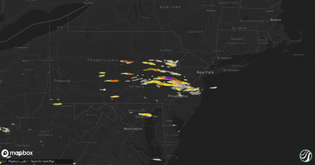
Hail Map on May 29, 2019
Get this storm
May 29 map
$229
one time, instant access
Download today. No call, no setup
Keep the $229
Bought the map and want the full workflow? Apply the entire $229 to a subscription within 7 days. None of it is wasted.
Every map, not just this one
This buys you this map. Subscription and you get every map we run, in the markets you choose from a few cities to whole states to nationwide. Plus real-time alerts the moment a storm fires.
Contact data
Name, contact info, occupancy, even credit band for addresses in the footprint. You go from where it hit to who to call.
Become the source they trust
Unlimited branding weather history reports on demand. You already have the documented answer ready for the property owner, and you are the one who showed up with it.
Property data and RoofTrace estimates
Pull up any address you have got, its value and the exact code rules for that jurisdiction, straight from One Click Code. Then RoofTrace estimates the squares, pitch, and roof value, priced the way you price.
States Impacted by Hail Map on May 29, 2019
Storm reports
Virginia
| Date | Description |
|---|---|
| 05/29/20196:33 PM CDT | At least 15 trees down between halifax and nathalie. Time estimated from radar. |
| 05/29/20196:12 PM CDT | Numerous trees down across the county... Including charlotte court house and red house. |
| 05/29/20195:25 PM CDT | Trees down on philpott drive. |
| 05/29/20195:20 PM CDT | 7 trees down in the brookneal area. |
| 05/29/20195:00 PM CDT | Half dollar size hail reported in fairy stone park. Time estimated from radar. |
| 05/29/20194:53 PM CDT | Two trees down in the dugspur area of carroll county. |
| 05/29/20194:52 PM CDT | Thunderstorm winds snapped several trees and large branches on mt. Calvary road. In addition... A few shingles were blown off at least one home... A shed was destroyed |
| 05/29/20194:44 PM CDT | Trees down near blue grass trail and spring branch rd. |
| 05/29/20194:38 PM CDT | Tree down on joppa mill rd. |
| 05/29/20194:36 PM CDT | Wsls viewer reported shattered windows to a residence on emmaus church rd in moneta. Time estimated from radar. |
| 05/29/20194:34 PM CDT | Multiple trees down between sandy level rd and goodview rd. |
| 05/29/20194:30 PM CDT | Multiple trees down in the eagle rock area. |
| 05/29/20194:30 PM CDT | Tree down on trailer on bruno drive. No injuries reported. |
| 05/29/20194:30 PM CDT | Power line down in the 5000 block of craig creek rd. |
| 05/29/20194:16 PM CDT | Tree down on whittaker ave. |
| 05/29/20194:16 PM CDT | Tree down on lindbergh ln. Time estimated by radar. |
| 05/29/20194:15 PM CDT | Multiple trees down in wythe county. |
| 05/29/20194:12 PM CDT | Three large treetops snapped off along with two large tree limbs fell. A tree fell in a neighboring yard as well. Time radar-estimated. |
| 05/29/20194:06 PM CDT | Trees down on multiple cars along surrey avenue. |
| 05/29/20194:05 PM CDT | 4 trees snapped off near the intersection of cleveland ave and thompson memorial drive. |
| 05/29/20194:05 PM CDT | Multiple trees down in the potts creek area of the county. Power lines also reported down. Time estimated by radar. |
| 05/29/20194:03 PM CDT | Large limb down on power line. Time estimated by radar. |
| 05/29/20193:59 PM CDT | Severe trees down south of cleveland. |
| 05/29/20193:45 PM CDT | Large limbs reported down near 1700th block of boxwood drive. Timing estimated by radar. |
| 05/29/20193:42 PM CDT | Widespread trees down near lowesville road and indian creek road. One tree fell on a business. Time from radar. |
| 05/29/20193:40 PM CDT | Trees and power lines down county wide in smyth county. |
| 05/29/20193:35 PM CDT | Trees down near the city of norton. |
| 05/29/20193:29 PM CDT | Multiple trees down near the pedlar river and rt 60. |
| 05/29/20193:25 PM CDT | Tree down at the saltville golf course. Time estimated by radar. |
| 05/29/20193:15 PM CDT | Several trees down just south of pound. |
| 05/29/20192:50 PM CDT | Small trees down. Time estimated from radar. Gravel roads washed out. |
| 05/29/20192:37 PM CDT | Tree down. Time estimated from radar. |
| 05/29/20192:34 PM CDT | Several trees down north of pound virginia. |
| 05/29/20192:30 PM CDT | A local report indicates 1.00 inch wind near 1 SE BLOWING ROCK |
| 05/29/20191:10 AM CDT | At 609 PM EDT, severe thunderstorms were located along a line extending from near Evington to Hurt to near Pittsville, moving east at 30 mph. HAZARD...60 mph wind gusts and quarter size hail. SOURCE...Radar indicated. IMPACT...Hail damage to vehicles is expected. Expect wind damage to roofs, siding, and trees. Locations impacted include... Altavista... Hurt... Gretna... Brookneal... and Keysville. |
| 05/29/201912:55 AM CDT | At 554 PM EDT, a severe thunderstorm was located near Glasgow, moving east at 55 mph. HAZARD...60 mph wind gusts. SOURCE...Radar indicated. IMPACT...Expect damage to roofs, siding, and trees. Locations impacted include... Lexington... Buena Vista... Amherst... Glasgow... and Forks Of Buffalo.This includes The following Location VMI. |
| 05/29/201912:52 AM CDT | At 552 PM EDT, a severe thunderstorm was located near Collierstown, moving east at 55 mph. HAZARD...60 mph wind gusts. SOURCE...Radar indicated. IMPACT...Expect damage to roofs, siding, and trees. Locations impacted include... Lexington... Buena Vista... Amherst... Glasgow... and Forks Of Buffalo.This includes The following Location VMI. |
| 05/29/201912:26 AM CDT | At 526 PM EDT, a severe thunderstorm was located over Goodview, moving east at 30 mph. HAZARD...60 mph wind gusts and quarter size hail. SOURCE...Radar indicated. IMPACT...Hail damage to vehicles is expected. Expect wind damage to roofs, siding, and trees. Locations impacted include... Bedford... Altavista... Hurt... Stewartsville... and Huddleston.This includes The following Location The National D-Day Memorial. |
| 05/29/201912:11 AM CDT | At 510 PM EDT, severe thunderstorms were located along a line extending from near Alleghany to near Potts Creek to near Craig Springs, moving east at 45 mph. HAZARD...60 mph wind gusts. SOURCE...Radar indicated. IMPACT...Expect damage to roofs, siding, and trees. Locations impacted include... Alleghany... Bedford... Covington... Clifton Forge... and Buchanan. |
| 05/28/201911:37 PM CDT | At 436 PM EDT, a severe thunderstorm was located 7 miles southwest of Trammel, or 13 miles east of Wise, moving east at 45 mph. HAZARD...60 mph wind gusts and quarter size hail. SOURCE...Radar indicated. IMPACT...Hail damage to vehicles is expected. Expect wind damage to roofs, siding, and trees. Locations impacted include... Abingdon, Lebanon, Cleveland Va, Coeburn, Glade Spring, St. Paul, Dungannon, Emory-Meadow View, Rosedale, Lindell, Castlewood, Holston and Hansonville. |
| 05/28/201911:36 PM CDT | At 436 PM EDT, severe thunderstorms were located along a line extending from near Alderson to near Wolfcreek to near Elgood, moving east at 40 mph. HAZARD...60 mph wind gusts. SOURCE...Radar indicated. IMPACT...Expect damage to roofs, siding, and trees. Locations impacted include... Alleghany... Covington... Clifton Forge... Lewisburg... and White Sulphur Springs.This includes The following Location The West Virginia StateFairgrounds. |
| 05/28/201911:31 PM CDT | At 430 PM EDT, a severe thunderstorm was located over Mc Coy, moving east at 35 mph. HAZARD...60 mph wind gusts and quarter size hail. SOURCE...Radar indicated. IMPACT...Hail damage to vehicles is expected. Expect wind damage to roofs, siding, and trees. Locations impacted include... Blacksburg... Christiansburg... Radford... Pearisburg... and Pembroke.This includes The following Location Virginia Tech. |
| 05/28/201911:17 PM CDT | At 417 PM EDT, a severe thunderstorm was located over Wise, moving southeast at 30 mph. HAZARD...60 mph wind gusts. SOURCE...Radar indicated. IMPACT...Expect damage to roofs, siding, and trees. Locations impacted include... Norton, Wise, Coeburn, St. Paul, Dungannon and Pardee. |
| 05/28/201911:13 PM CDT | At 413 PM EDT, severe thunderstorms were located along a line extending from Shady Spring to near Elton to near Piney View, moving east at 50 mph. HAZARD...60 mph wind gusts and quarter size hail. SOURCE...Radar indicated. IMPACT...Hail damage to vehicles is expected. Expect wind damage to roofs, siding, and trees. Locations impacted include... Lewisburg... Rainelle... Alderson... Rupert... and Quinwood. |
| 05/28/201911:02 PM CDT | At 401 PM EDT, a severe thunderstorm was located over Whitaker, or near Whitesburg, moving east at 50 mph. HAZARD...60 mph wind gusts. SOURCE...Radar indicated. IMPACT...Expect damage to roofs, siding, and trees. Locations impacted include... Pound. |
| 05/28/201910:25 PM CDT | At 324 PM EDT, severe thunderstorms were located along a line extending from Wharton to 6 miles southeast of Argo to 8 miles south of Trammel, moving east at 40 mph. HAZARD...60 mph wind gusts and quarter size hail. SOURCE...Radar indicated. IMPACT...Hail damage to vehicles is expected. Expect wind damage to roofs, siding, and trees. Locations impacted include... Bluefield... Wytheville... Bland... Princeton... and Marion.This includes The following Location Mercer County Airport. |
| 05/28/201910:18 PM CDT | At 317 PM EDT, severe thunderstorms were located from 6 miles north of Quinwood...through Babcock State Park...to 8 miles south of Burnwell, moving east at 45 mph. HAZARD...60 mph wind gusts and quarter size hail. SOURCE...Radar indicated. IMPACT...Hail damage to vehicles is expected. Expect wind damage to roofs, siding, and trees. Locations impacted include... Lewisburg... Rainelle... Alderson... Rupert... and Quinwood. |
| 05/28/201910:17 PM CDT | At 316 PM EDT, a severe thunderstorm was located over Shelby Gap, or near Clintwood, moving east at 35 mph. Additional severe thunderstorms are also expected to move into the warned area over the next hour. HAZARD...70 mph wind gusts and ping pong ball size hail. SOURCE...Radar indicated. IMPACT...People and animals outdoors will be injured. Expect hail damage to roofs, siding, windows, and vehicles. Expect considerable tree damage. Wind damage is also likely to mobile homes, roofs, and outbuildings. Locations impacted include... Clintwood, Grundy, Haysi, Breaks Interstate, Davenport, John Flannagan Lake, Big Rock, Trammel, Clinchco, Oakwood, Stacy, Nora, Vansant, Hurley, McClure and Roseann. |
| 05/28/201910:13 PM CDT | At 312 PM EDT, a severe thunderstorm was located near Hinch, or 11 miles south of Logan, moving east at 45 mph. HAZARD...60 mph wind gusts and quarter size hail. SOURCE...Radar indicated. IMPACT...Hail damage to vehicles is expected. Expect wind damage to roofs, siding, and trees. Locations impacted include... Pineville, Oceana, Man, Hanover, R.d. Bailey Lake, Gilbert Creek, Mallory, Amherstdale-Robinette, Twin Falls State Park, Hinch, Mount Gay-Shamrock, Gilbert, Chauncey, Coal Mountain, Bruno, Wolf Pen, Sarah Ann, Meador, Clear Fork and Cyclone. |
| 05/28/201910:09 PM CDT | At 309 PM EDT, a severe thunderstorm was located over Jenkins, or 10 miles west of Clintwood, moving east at 25 mph. HAZARD...60 mph wind gusts and half dollar size hail. SOURCE...Radar indicated. IMPACT...Hail damage to vehicles is expected. Expect wind damage to roofs, siding, and trees. Locations impacted include... Jenkins, Fleming-Neon, Adamson, Shelby Gap, Fishpond Lake, Beefhide, Cromona, Burdine, Potters Fork, Payne Gap, Gaskill and Dunham. |
| 05/28/201910:09 PM CDT | At 309 PM EDT, a severe thunderstorm was located near Clintwood, moving east at 35 mph. HAZARD...60 mph wind gusts and quarter size hail. SOURCE...Radar indicated. IMPACT...Hail damage to vehicles is expected. Expect wind damage to roofs, siding, and trees. Locations impacted include... Pound. |
| 05/28/20199:20 PM CDT | At 219 PM EDT, a severe thunderstorm was located over Brookneal, moving northeast at 20 mph. HAZARD...60 mph wind gusts and quarter size hail. SOURCE...Radar indicated. IMPACT...Hail damage to vehicles is expected. Expect wind damage to roofs, siding, and trees. Locations impacted include... Brookneal... Charlotte Court House... Phenix... Red House... and Madisonville. |
| 05/28/20198:50 PM CDT | Several trees down and some light damage to weak structures in eastville. |
Arkansas
| Date | Description |
|---|---|
| 05/29/20196:30 PM CDT | Wind damage to corning high school. Mainly roof problems. |
| 05/29/20196:00 PM CDT | Large limbs down and minor shingle damage. |
| 05/29/20195:56 PM CDT | Large trees down near bryant... Ar. |
| 05/29/20195:45 PM CDT | Large trees were blown down in vilonia. |
| 05/29/20195:39 PM CDT | Large trees were blown down near homes north of maynard. |
| 05/29/20195:23 PM CDT | Trees down in conway... Ar. |
| 05/29/20195:20 PM CDT | Trees downed in the city of conway. |
| 05/29/20195:20 PM CDT | Trees were blown down on a house in ravenden springs. |
| 05/29/20194:58 PM CDT | A local report indicates 1.75 inch wind near CONCORD |
| 05/29/20194:50 PM CDT | Thunderstorm wind gust above 60 mph near timber lake reservoir. |
| 05/29/20194:36 PM CDT | Trees down reported by police dispatch in de queen... Ar. |
| 05/29/20194:12 PM CDT | Half dollar size hail in clinton... Ar. |
| 05/29/20194:10 PM CDT | Powerlines were down near hwy. 65 and old hwy. 9. No power at the sheriff office. |
| 05/29/20191:00 PM CDT | Relayed by nws springfield. |
| 05/29/201911:37 AM CDT | Police report trees and power lines down. Report relayed by media. |
| 05/29/201911:30 AM CDT | Trees and large limbs down all over siloam springs. |
| 05/29/201911:30 AM CDT | A local report indicates 67 MPH wind near SILOAM SPRINGS |
| 05/29/201911:22 AM CDT | Multiple trees down... Blocking dawn hill road northeast of siloam springs. Report relayed by media. |
| 05/29/20197:50 AM CDT | At 1250 PM CDT, a severe thunderstorm was located 3 miles east of Cass, moving northeast at 30 mph. HAZARD...60 mph wind gusts and quarter size hail. SOURCE...Radar indicated. IMPACT...Hail damage to vehicles is expected. Expect wind damage to roofs, siding, and trees. Locations in or near the path include... St. Paul... Cass... Saint Paul... Pettigrew... Kingston... Witter... Boston... Dutton... Barnes... Red Star... Redding... Weathers... Brashears... Combs... Turners Bend... Taft... Paradise... |
| 05/29/20195:42 AM CDT | At 1041 AM CDT, severe thunderstorms were located along a line extending from 4 miles southwest of Leach to 4 miles northeast of Tahlequah to 5 miles west of Cherokee Landing State Park, moving east at 45 mph. HAZARD...60 mph wind gusts and quarter size hail. SOURCE...Radar indicated. IMPACT...Hail damage to vehicles is expected. Expect wind damage to roofs, siding, and trees. Locations in or near the path include... Fayetteville... Bentonville... Tahlequah... Siloam Springs... Farmington... Prairie Grove... Gentry... Tontitown... Lincoln... Decatur... Westville... Greenland... West Siloam Springs... Colcord... Kansas... Highfill... Watts... Oaks... Springtown... Northwest Arkansas Regional Air...This includes Interstate 49 between mile markers 55 and 59. |
| 05/29/201912:58 AM CDT | At 558 PM CDT, a severe thunderstorm was located over Bryant, moving northeast at 30 mph. HAZARD...60 mph wind gusts and nickel size hail. SOURCE...Radar indicated. IMPACT...Expect damage to roofs, siding, and trees. Locations impacted include... Little Rock... North Little Rock... Benton... Sherwood... Jacksonville... West Little Rock... Maumelle... Bryant... Downtown Little Rock... North Little Rock Airport... Southwest Little Rock... Little Rock AFB... Shannon Hills... Argenta... Otter Creek... Gravel Ridge... Protho Junction... Lakewood... Camp Robinson... Geyer Springs...This includes the following highways... Interstate 30 between mile markers 119 and 142. Interstate 40 between mile markers 143 and 160. Interstate 430 between mile markers 1 and 12. Interstate 530 near mile marker 1. Interstate 630 between mile markers 1 and 7. Interstate 440 between mile markers 1 and 3, and between milemarkers 9 and 14. US Highway 67 between mile markers 1 and 9. |
| 05/29/201912:56 AM CDT | At 556 AM CDT, severe thunderstorms were located along a line extending from Mount Pleasant to near Pangburn, moving east at 45 mph. HAZARD...60 mph wind gusts and quarter size hail. SOURCE...Radar indicated. IMPACT...Hail damage to vehicles is expected. Expect wind damage to roofs, siding, and trees. Locations impacted include... Batesville... Newport... Pocahontas... Walnut Ridge... Hoxie... Black Rock... Lake Charles State Park... Cave City... Tuckerman... Diaz... Newark... Swifton... Imboden... Pangburn... College City... Portia... Grubbs... Pleasant Plains... Strawberry... Lynn...This includes US Highway 67 between mile markers 59 and 101, andbetween mile markers 109 and 121. |
| 05/29/201912:28 AM CDT | At 528 PM CDT, severe thunderstorms were located along a line extending from Quitman to near Enola to near Mayflower, moving east at 40 mph. HAZARD...60 mph wind gusts and penny size hail. SOURCE...Radar indicated. IMPACT...Expect damage to roofs, siding, and trees. Locations impacted include... Jacksonville... Cabot... Little Rock AFB... Beebe... Ward... Vilonia... Austin in Lonoke County... Rose Bud... Enola... Mount Vernon... Old Austin... Parnell... Gravel Hill... Olmstead... Gibson... Antioch in White County... Barney... Sidon... Pickens in White County... Floyd...This includes US Highway 67 between mile markers 12 and 32. |
| 05/29/201912:15 AM CDT | At 514 PM CDT, severe thunderstorms were located along a line extending from 7 miles northwest of Dalton to near Ravenden Springs to near Annieville, moving east at 30 mph. HAZARD...60 mph wind gusts and quarter size hail. SOURCE...Radar indicated. IMPACT...Hail damage to vehicles is expected. Expect wind damage to roofs, siding, and trees. Locations impacted include... Pocahontas... Imboden... Ravenden... Maynard... Biggers... O'Kean... Ravenden Springs... Annieville... Dalton... Attica... Middlebrook... Ingram... Shannon... Birdell... Elnora... Elkins Park... Brakebill... Warm Springs... Hamil... Stokes... |
| 05/29/201912:13 AM CDT | At 513 AM CDT, severe thunderstorms were located along a line extending from Herpel to near Choctaw, moving east at 45 mph. HAZARD...60 mph wind gusts and nickel size hail. SOURCE...Radar indicated. IMPACT...Expect damage to roofs, siding, and trees. Locations impacted include... Batesville... Heber Springs... Mountain View... Fairfield Bay... Melbourne... Cave City... Greers Ferry... Quitman... Pangburn... Cushman... Mount Pleasant... Damascus... Pleasant Plains... Shirley... Concord... Magness... Sidney... Moorefield... Higden... Salado... |
| 05/29/201912:09 AM CDT | At 508 PM CDT, severe thunderstorms were located along a line extending from Whipple to Wooster to near Toad Suck, moving east at 40 mph. HAZARD...60 mph wind gusts and nickel size hail. SOURCE...Radar indicated. IMPACT...Expect damage to roofs, siding, and trees. Locations impacted include... Conway... Greenbrier... Vilonia... Mayflower... Wooster... Quitman... Guy... Damascus... Enola... Twin Groves... Menifee... Mount Vernon... Pickles Gap... Fairbanks... Mallet Town... Whipple... Springhill... Toad Suck... Woolly Hollow State Park... Holland...This includes Interstate 40 between mile markers 118 and 137. |
| 05/28/201911:47 PM CDT | At 446 PM CDT, a severe thunderstorm was located just southeast of Gillham, moving northeast at 35 mph. HAZARD...60 mph wind gusts and penny size hail. SOURCE...Radar indicated. At 436 PM, trees were downed in Dequeen from this storm. IMPACT...Expect damage to roofs, siding, and trees. Locations impacted include... De Queen, Umpire, Athens and Burg. |
| 05/28/201911:45 PM CDT | At 445 PM CDT, a severe thunderstorm was located 2 miles west of Perryville, moving northeast at 30 mph. HAZARD...60 mph wind gusts and quarter size hail. SOURCE...Radar indicated. IMPACT...Hail damage to vehicles is expected. Expect wind damage to roofs, siding, and trees. Locations impacted include... Conway... Morrilton... Perryville... Wooster... Oppelo... Menifee... Perry... Adona... Houston... Sequoya Park... Hill Creek... Toad Suck... Springfield... Pickles Gap... Plumerville... Bigelow... Casa... Aplin... Fourche... Antioch in Perry County...This includes Interstate 40 between mile markers 107 and 130. |
| 05/28/201911:38 PM CDT | At 437 AM CDT, severe thunderstorms were located along a line extending from near Advance to Clinton, moving northeast at 55 mph. HAZARD...60 mph wind gusts and nickel size hail. SOURCE...Radar indicated. IMPACT...Expect damage to roofs, siding, and trees. Locations impacted include... Mountain View... Clinton... Fairfield Bay... Melbourne... Horseshoe Bend... Calico Rock... Greers Ferry... Oxford... Shirley... Concord... Pineville... Franklin... Higden... Lone Star... Wideman... Herron... Gid... Herpel... Advance... Sugar Loaf Recreation Area... |
| 05/28/201911:30 PM CDT | At 430 PM CDT, a severe thunderstorm was located 10 miles northeast of Greers Ferry, or 13 miles north of Heber Springs, moving northeast at 25 mph. HAZARD...60 mph wind gusts and half dollar size hail. SOURCE...Radar indicated. IMPACT...Hail damage to vehicles is expected. Expect wind damage to roofs, siding, and trees. Locations impacted include... Mountain View... Cushman... Concord... Herpel... Brandenberg... Croker... Bethesda... Guion... Ben... Almond... Prim... Luber... Marcella... Drasco... Wolf Bayou... Lafferty... Twin Creek... Saint James... Woodrow... Ida... |
| 05/28/201911:05 PM CDT | At 404 PM CDT, a severe thunderstorm was located 4 miles southwest of Clinton, moving northeast at 30 mph. HAZARD...60 mph wind gusts and half dollar size hail. SOURCE...Radar indicated. IMPACT...Hail damage to vehicles is expected. Expect wind damage to roofs, siding, and trees. Locations impacted include... Clinton... Fairfield Bay... Greers Ferry... Shirley... Fairfield Bay Marina... Old Lexington... Choctaw... Sugar Loaf Recreation Area... Parma... Edgemont... Prim... Rushing... Turkey Creek... Hill Creek Recreation Area... Culpepper... Fox... Formosa... South Fork Recreation Area... Crabtree... Brewer... |
| 05/28/201910:05 PM CDT | At 304 AM CDT, severe thunderstorms were located along a line extending from near Fern to near Fort Chaffee, moving east at 60 mph. HAZARD...60 mph wind gusts and quarter size hail. SOURCE...Radar indicated. IMPACT...Hail damage to vehicles is expected. Expect wind damage to roofs, siding, and trees. Locations impacted include... Clarksville... Booneville... Paris... Jasper... Lamar... Magazine... Knoxville... Subiaco... Hartman... Scranton... Ratcliff... Blue Mountain... Upper Buffalo Wilderness Area... Devils Knob... Hoyt... Midway in Logan County... Holman... Rosetta... Woodland... Hinkle...This includes Interstate 40 between mile markers 44 and 72. |
| 05/28/20199:42 PM CDT | At 242 PM CDT, a severe thunderstorm was located 3 miles west of Marshall, moving northeast at 30 mph. HAZARD...Ping pong ball size hail and 60 mph wind gusts. SOURCE...Radar indicated. IMPACT...People and animals outdoors will be injured. Expect hail damage to roofs, siding, windows, and vehicles. Expect wind damage to roofs, siding, and trees. Locations impacted include... Marshall... Thola... Marsena... Kay... Duff... Point Peter... Maumee... Bohannon... Imo... Elberta... Watts... Leslie... Big Flat... Gilbert... Zach... Canaan... Morning Star... Silver Hill... Maumee Crossing... Landis... |
| 05/28/20199:37 PM CDT | At 237 PM CDT, a severe thunderstorm was located 3 miles north of Greenwood, moving northeast at 35 mph. HAZARD...60 mph wind gusts and quarter size hail. SOURCE...Radar indicated. IMPACT...Hail damage to vehicles is expected. Expect wind damage to roofs, siding, and trees. Locations in or near the path include... Ozark... Charleston... Greenwood... Barling... Lavaca... Mulberry... Altus... Branch... Denning... Wiederkehr Village... Bloomer... Burnville... Jenny Lind... Central City... Jethro... Vesta... Cecil... Lonelm... Ursula... Etna...This includes Interstate 40 in Arkansas between mile markers 24 and40. |
| 05/28/20199:05 PM CDT | At 205 PM CDT, a severe thunderstorm was located near Moore, or 18 miles southeast of Jasper, moving northeast at 30 mph. HAZARD...60 mph wind gusts and quarter size hail. SOURCE...Radar indicated. IMPACT...Hail damage to vehicles is expected. Expect wind damage to roofs, siding, and trees. Locations impacted include... Marshall... Marsena... Eula... Bohannon... Duff... Moore... Point Peter... Witts Spring... St. Joe... Pindall... Gilbert... Zach... Bass... Canaan... Silver Hill... Mt Judea... Snowball... Cowell... Lurton... Woolum Recreation Area... |
| 05/28/20198:40 PM CDT | At 139 PM CDT, severe thunderstorms were located along a line extending from Merriam Woods to 10 miles northeast of Diamond City, moving northeast at 45 mph. HAZARD...60 mph wind gusts and half dollar size hail. SOURCE...Trained weather spotters. Half dollar size hail and wind damage have been reported with these storms. IMPACT...Hail damage to vehicles is expected. Expect wind damage to roofs, siding, and trees. Locations impacted include... Bull Shoals Lake... Lake Taneycomo... Kissee Mills... Taneyville... Theodosia... Wasola... Sundown... Brixey... Noble... Willhoit... Brownbranch... Protem... Thornfield... Rueter... Rome... Squires... Bradleyville... Rockbridge... Long Run... Isabella... |
| 05/28/20198:16 PM CDT | At 116 PM CDT, a severe thunderstorm was located near Devils Knob, or 13 miles north of Clarksville, moving northeast at 30 mph. HAZARD...60 mph wind gusts and quarter size hail. SOURCE...Radar indicated. IMPACT...Hail damage to vehicles is expected. Expect wind damage to roofs, siding, and trees. Locations impacted include... Dillen... Upper Buffalo Wilderness Area... Walnut... Rosetta... Devils Knob... Wayton... Boxley... Mossville... Salus... Catalpa... Fort Douglas... Ozone... Fallsville... Crossroad... Swain... Haw Creek Falls Campground... Deer... Dixon Ridge... Cowell... Nail... |
| 05/28/20198:08 PM CDT | At 108 PM CDT, a severe thunderstorm was located over Pettigrew, or 19 miles south of Huntsville, moving northeast at 40 mph. HAZARD...60 mph wind gusts and quarter size hail. SOURCE...Radar indicated. IMPACT...Hail damage to vehicles is expected. Expect wind damage to roofs, siding, and trees. Locations impacted include... Lost Valley State Park... Upper Buffalo Wilderness Area... Oak Grove in Johnson County... Wayton... Boxley... Mossville... Friley... Yale... Low Gap... Fallsville... Parthenon... Swain... Gum Springs in Newton County... Oark... Dixon Ridge... Wolf Pen Campground... Arbaugh... Ponca... |
Missouri
| Date | Description |
|---|---|
| 05/29/20196:50 PM CDT | Numerous trees down from dexter to puxico due to severe wind gusts. Power lines down as well. |
| 05/29/20196:50 PM CDT | Trees down on roads and homes in dexter. |
| 05/29/20196:05 PM CDT | Medium sized tree branches down east of fairdealing. Time estimated by radar. |
| 05/29/20195:58 PM CDT | Late report. Trees down and 60 mph wind gust estimated. |
| 05/29/20195:57 PM CDT | Large portion of tree blown down in hyde park. Via twitter with picture. |
| 05/29/20195:55 PM CDT | Many trees down throughout the county. Numerous power outages as well. Time estimated by radar. |
| 05/29/20195:53 PM CDT | Wind gust measured at raws observation station in doniphan. |
| 05/29/20195:50 PM CDT | Trees down in doniphan. One home sustained roof damage from fallen tree. |
| 05/29/20195:10 PM CDT | Tree down on county road 224 near highway cc. |
| 05/29/20194:49 PM CDT | A local report indicates 1.00 inch wind near COTTLEVILLE |
| 05/29/20194:44 PM CDT | Trees down on powerlines and blocking roadway at the intersection of 7th and pine st. Also several limbs down in yards. |
| 05/29/20194:44 PM CDT | A local report indicates 1.25 inch wind near 1 SSE O'FALLON |
| 05/29/20193:28 PM CDT | Tree fell onto power lines and is on fire off of hwy 160 about 5 miles southwest of west plains. |
| 05/29/20191:42 PM CDT | Trees down in the kissee mills area. |
| 05/29/20191:37 PM CDT | 2 inch hail in powersite. Picture via social media with time estimated from radar. |
| 05/29/20191:37 PM CDT | 1 inch hail 1 ene of powersite. |
| 05/29/20191:37 PM CDT | Picture of large uprooted tree in powersite. Time estimated from radar. |
| 05/29/20191:36 PM CDT | Large tree fell on house. Picture via social media and time estimated from radar. |
| 05/29/20191:32 PM CDT | Multiple areas with trees and powerlines down from hollister... Kirbyville and powersite areas. |
| 05/29/20191:30 PM CDT | 1.25 inch hail in branson. Via social media picture. |
| 05/29/20191:30 PM CDT | 1 inch hail at the branson fire department. |
| 05/29/20191:30 PM CDT | Trees down in area. |
| 05/29/20191:30 PM CDT | Reports of trees down across the city of branson from pointe royale to branson hills parkway to city hall. At least one tree estimated at 36 inches in diameter down on |
| 05/29/20191:30 PM CDT | Private weather station measured 75 mph wind gust in hollister. Social media pictures also show tree damage and hail damage to siding. |
| 05/29/20191:30 PM CDT | Tree down and hail damage to vehicle windows off of hwy 76 east of branson. |
| 05/29/20191:30 PM CDT | Baseball sized hail reported near the holiday hills resort by e hwy 76. Time estimated from radar. |
| 05/29/20191:30 PM CDT | Corrects previous hail report from 2 nw kirbyville. Pictures of ping pong and up to 2 inch sized hail east of branson near east 76 and t highway. |
| 05/29/20191:30 PM CDT | 1.25 inch hail. |
| 05/29/20191:27 PM CDT | Hollister resident had 1.75 inch hail. |
| 05/29/20191:27 PM CDT | Pictures of multiple trees down in the country bluff estates area... With hail damage to trees as well. Limbs up to 12 inches in diameter also broken off in the welk re |
| 05/29/20191:27 PM CDT | Tree damage at the college of the ozarks. |
| 05/29/20191:20 PM CDT | Half dollar size hail. |
| 05/29/201912:42 PM CDT | Mesonet station crwm7 cassville raws. |
| 05/29/20198:44 AM CDT | An ef1 tornado resulted in a house loosing a portion of its roof including the roof decking. Several small outbuildings or porches lost part of their roofs or walls. At |
| 05/29/20198:10 AM CDT | One tree down in town. Winds measured off home weather station at 60mph. |
| 05/29/20197:53 AM CDT | Delayed report. Trees reported down around cape girardeau... Including a tree that fell onto a house. Time estimated from radar. |
| 05/29/20197:42 AM CDT | At 1241 PM CDT, severe thunderstorms were located along a line extending from 6 miles north of Beaver to Eureka Springs to near Clifty, moving east at 35 mph. HAZARD...60 mph wind gusts and quarter size hail. SOURCE...Radar indicated. IMPACT...Hail damage to vehicles is expected. Expect wind damage to roofs, siding, and trees. Locations impacted include... Branson... Table Rock Lake... Table Rock State Park... Silver Dollar City... Kimberling City... Shell Knob... Reeds Spring... Indian Point... Branson West... Galena... Mccord Bend... Blue Eye... Coney Island... Cape Fair... Lampe... |
| 05/29/20197:20 AM CDT | At 1219 PM CDT, severe thunderstorms were located along a line extending from near Gateway to 3 miles northwest of Hindsville, moving east at 30 mph. HAZARD...60 mph wind gusts and penny size hail. SOURCE...Radar indicated. IMPACT...Expect damage to roofs, siding, and trees. Locations in or near the path include... Berryville... Huntsville... Eureka Springs... Green Forest... Beaver... Hindsville... Carrollton... Rudd... Forum... Hobbs State Park... Clifty... Withrow Springs State Park... War Eagle... Marble... Osage... Urbanette... Rule... Grandview... Goshen... Alpena... |
| 05/29/20197:07 AM CDT | At 1207 PM CDT, severe thunderstorms were located along a line extending from near Pea Ridge to near War Eagle, moving northeast at 40 mph. HAZARD...60 mph wind gusts and quarter size hail. SOURCE...Radar indicated. IMPACT...Hail damage to vehicles is expected. Expect wind damage to roofs, siding, and trees. Locations impacted include... Table Rock Lake... Roaring River State Park... Cassville... Shell Knob... Seligman... Washburn... Golden... Emerald Beach... Eagle Rock... Chain-O-Lakes... Arrow Point... Wheelerville... Jenkins... |
| 05/29/20196:30 AM CDT | At 1129 AM CDT, severe thunderstorms were located along a line extending from 2 miles northwest of Decatur to 6 miles south of Highfill to 6 miles southwest of Lincoln, moving east at 40 mph. HAZARD...60 mph wind gusts and quarter size hail. SOURCE...Radar indicated. IMPACT...Hail damage to vehicles is expected. Expect wind damage to roofs, siding, and trees. Locations in or near the path include... Fayetteville... Springdale... Rogers... Bentonville... Siloam Springs... Bella Vista... Lowell... Farmington... Pea Ridge... Prairie Grove... Gentry... Elkins... Tontitown... Bethel Heights... West Fork... Lincoln... Cave Springs... Decatur... Greenland... Highfill...This includes Interstate 49 between mile markers 52 and 93. |
| 05/29/20192:46 AM CDT | At 745 PM CDT, a severe thunderstorm was located over Cape Girardeau, moving northeast at 30 mph. HAZARD...60 mph wind gusts. SOURCE...Radar indicated. IMPACT...Expect damage to roofs, siding, and trees. Locations impacted include... Cape Girardeau, Trail Of Tears State Park, Gordonville, Ware and East Cape Girardeau. |
| 05/29/20192:36 AM CDT | At 735 PM CDT, severe thunderstorms were located along a line extending from near Kelso to 6 miles north of Bertrand, moving northeast at 50 mph. These storms have a history of wind damage. HAZARD...70 mph wind gusts. SOURCE...Radar indicated. IMPACT...Expect considerable tree damage. Damage is likely to mobile homes, roofs, and outbuildings. Locations impacted include... Scott City, Anna, Jonesboro, Mounds, Dongola, Tamms, Olive Branch, Horseshoe Lake Conservation Area, Ullin, Thebes, Olmsted, Pulaski and Mill Creek. |
| 05/29/20191:43 AM CDT | At 642 AM CDT, a severe thunderstorm was located near Cascade, or 10 miles northeast of Greenville, moving northeast at 35 mph. HAZARD...60 mph wind gusts and quarter size hail. SOURCE...Radar indicated. IMPACT...Hail damage to vehicles is expected. Expect wind damage to roofs, siding, and trees. Locations impacted include... Cascade. |
| 05/29/20191:38 AM CDT | At 637 PM CDT, severe thunderstorms were located along a line extending from Wappapello to near Glennonville, moving northeast at 35 mph. HAZARD...60 mph wind gusts. SOURCE...Radar indicated. IMPACT...Expect damage to roofs, siding, and trees. Locations impacted include... Dexter, Bernie, Bloomfield, Puxico, Essex, Qulin, Fisk, Dudley, Wappapello, Baker, Penermon and Rombauer. |
| 05/29/201912:52 AM CDT | At 552 PM CDT, a severe thunderstorm was located near Knobel, or 9 miles southeast of Corning, moving northeast at 25 mph. HAZARD...60 mph wind gusts and quarter size hail. SOURCE...Radar indicated. IMPACT...Hail damage to vehicles is expected. Expect wind damage to roofs, siding, and trees. Locations impacted include... Piggott, Corning, Chalk Bluff Natural Area, Lafe, Knobel, St. Francis, Pollard, Greenway, McDougal, Peach Orchard, Saint Francis, Crockett, Stonewall, Tipperary, Hickoria, Knob and Chalk Bluff Battlefield Park. |
| 05/29/201912:52 AM CDT | At 551 PM CDT, severe thunderstorms were located along a line extending from 8 miles south of Hunter to near Success, moving east at 45 mph. HAZARD...60 mph wind gusts. SOURCE...Radar indicated. IMPACT...Expect damage to roofs, siding, and trees. Locations impacted include... Poplar Bluff, Doniphan, Naylor, Neelyville, Harviell, Budapest, Milltown, Oxly, Fairdealing, Brush Arbor and Grandin. |
| 05/29/201912:06 AM CDT | At 505 PM CDT, severe thunderstorms were located along a line extending from 8 miles southeast of Alton to near Ravenden, moving east at 35 mph. HAZARD...60 mph wind gusts and quarter size hail. SOURCE...Radar indicated. IMPACT...Hail damage to vehicles is expected. Expect wind damage to roofs, siding, and trees. Locations impacted include... Doniphan, Naylor, Budapest, Gatewood, Oxly, Fairdealing, Handy and Briar. |
| 05/28/201911:56 PM CDT | At 456 PM CDT, a severe thunderstorm was located over Drake, moving northeast at 20 mph. HAZARD...60 mph wind gusts and quarter size hail. SOURCE...Radar indicated. IMPACT...Hail damage to vehicles is expected. Expect wind damage to roofs, siding, and trees. Locations impacted include... Washington, Union, Owensville, New Haven, Gerald, Marthasville, Bland, Rosebud, Beaufort, Treloar, Dutzow, Mount Sterling, Drake, Swiss, Leslie, Canaan, Noser Mill, Lyon, Holstein and Bay. |
| 05/28/201911:52 PM CDT | At 452 PM CDT, a severe thunderstorm was located 8 miles northeast of Hardy, or 10 miles southeast of Mammoth Spring, moving northeast at 35 mph. HAZARD...60 mph wind gusts and quarter size hail. SOURCE...Radar indicated. IMPACT...Hail damage to vehicles is expected. Expect wind damage to roofs, siding, and trees. Locations impacted include... Myrtle... Wilderness... |
| 05/28/201911:27 PM CDT | At 427 PM CDT, a severe thunderstorm was located near Ellington, or 9 miles west of Piedmont, moving northeast at 20 mph. HAZARD...70 mph wind gusts and half dollar size hail. SOURCE...Radar indicated. IMPACT...Hail damage to vehicles is expected. Expect considerable tree damage. Wind damage is also likely to mobile homes, roofs, and outbuildings. Locations impacted include... Sam A. Baker State Park. |
| 05/28/201911:27 PM CDT | At 427 PM CDT, a severe thunderstorm was located near Mammoth Spring, or near Thayer, moving northeast at 40 mph. HAZARD...60 mph wind gusts and quarter size hail. SOURCE...Radar indicated. IMPACT...Hail damage to vehicles is expected. Expect wind damage to roofs, siding, and trees. Locations impacted include... Grand Gulf State Park... Thayer... Alton... Koshkonong... Wilderness... Couch... Greer... |
| 05/28/201911:19 PM CDT | At 419 PM CDT, a severe thunderstorm was located near Ellington, moving northeast at 15 mph. HAZARD...60 mph wind gusts and quarter size hail. SOURCE...Radar indicated. IMPACT...Hail damage to vehicles is expected. Expect wind damage to roofs, siding, and trees. Locations impacted include... Ellington, Annapolis, Des Arc, Sabula, Redford, Vulcan and Lesterville.This also includes Clearwater Lake Recreational Area. |
| 05/28/201911:13 PM CDT | At 413 PM CDT, a severe thunderstorm was located over Bland, moving northeast at 15 mph. HAZARD...60 mph wind gusts and quarter size hail. SOURCE...Radar indicated. IMPACT...Hail damage to vehicles is expected. Expect wind damage to roofs, siding, and trees. Locations impacted include... Owensville, Belle, Bland, Rosebud, Swiss, Mount Sterling, Drake, Canaan and Bay. |
| 05/28/20198:17 PM CDT | At 117 PM CDT, a severe thunderstorm was located near Indian Point, or near Kimberling City, moving northeast at 35 mph. HAZARD...60 mph wind gusts and half dollar size hail. SOURCE...Radar indicated. IMPACT...Hail damage to vehicles is expected. Expect wind damage to roofs, siding, and trees. Locations impacted include... Branson... Lake Taneycomo... Bull Shoals Lake... Table Rock Lake... Table Rock State Park... Hollister... Forsyth... Merriam Woods... Kissee Mills... Rockaway Beach... Bull Creek... Table Rock... Kirbyville... Powersite... Ridgedale... Ozark Beach... Walnut Shade... Edgewater Beach... |
| 05/28/20197:37 PM CDT | Measured wind gust at cape girardeau regional airport kcgi asos. |
| 05/28/20197:25 PM CDT | Trees down across the county. |
Kentucky
| Date | Description |
|---|---|
| 05/29/20194:25 PM CDT | A local report indicates 1.25 inch wind near 1 SW RICH POND |
| 05/29/20193:05 PM CDT | A local report indicates 1.00 inch wind near 9 N AUBURN |
| 05/29/20193:01 PM CDT | Large hail impacted the davis crossroads area of butler county. |
| 05/29/20192:50 PM CDT | A local report indicates 1.00 inch wind near 4 NW ANDERSON |
| 05/29/20192:38 PM CDT | Half dollar to golfball size hail. |
| 05/29/20192:35 PM CDT | Trees down in the princeton road and dawson springs road area. Time estimated by radar. |
| 05/29/20192:31 PM CDT | Public reported that multiple trees were down along jason ridge rd. In addition... Hail size range between quarter and ping pong ball size. |
| 05/29/20192:30 PM CDT | Quarter to ping pong sized hail and trees downed on jason ridge road... Near lake malone... In northeast todd county. |
| 05/29/20192:16 PM CDT | Trees down along clifty-kirkmansville road. Time estimated by radar. |
| 05/29/20192:14 PM CDT | Relayed via broadcast media on social media. |
| 05/29/20192:12 PM CDT | Dime to quarter size hail reported along highway 23. |
| 05/29/20192:12 PM CDT | Tree down blocking highway 805. |
| 05/29/20191:58 PM CDT | Large oak tree was downed by winds... And pulled out guidelines from a large radio tower as it fell. This then brought down the radio tower. |
| 05/29/20191:57 PM CDT | Trees down in the mudlick community. |
| 05/29/20191:56 PM CDT | Trees reported down near johns creek. |
| 05/29/20191:46 PM CDT | Multiple trees down along ky rt. 7 south of salyersville from the mason area to one mile south of ky rt. 404. |
| 05/29/20191:43 PM CDT | Delayed report. Dime to quarter size hail. Time estimated. |
| 05/29/20191:39 PM CDT | Trees down on highway 80 between nancy and somerset as well as a pontoon boat blown off of lake cumberland at pulaski county park. |
| 05/29/20191:38 PM CDT | Tree fell on a powerline. |
| 05/29/20191:38 PM CDT | Trees reported down around the city. |
| 05/29/20191:37 PM CDT | Trees down on cr 3384. Road blocked |
| 05/29/20191:35 PM CDT | Roof blown off carport at ventors lane. |
| 05/29/20191:30 PM CDT | A tree was uprooted. |
| 05/29/20191:25 PM CDT | Reported southeast of princeton along ky highway 91. |
| 05/29/20191:23 PM CDT | Trees and limbs reported to have been downed. |
| 05/29/20191:15 PM CDT | Downed tree fell over into house. |
| 05/29/20191:15 PM CDT | Roof blown off business. Roof on top of cars and blocking streets. |
| 05/29/20191:15 PM CDT | Estimated 60 mph winds. Broke out top of pear tree. Large limbs down. |
| 05/29/20191:12 PM CDT | A ham radio tower that had been mounted on the roof of the annex building beside the jail... And behind the courthouse in downtown prestonsburg... Was destroyed by thun |
| 05/29/20191:12 PM CDT | *** 1 fatal *** updated for nws storm survey that confirmed structural and tree damage in prestonsburg was caused by downburst winds of 70 to 80 mph. A roof was lifted |
| 05/29/20191:10 PM CDT | Tree fell on a house. |
| 05/29/20191:08 PM CDT | Estimated 60 mph winds. Broke out top of pear tree. Large limbs down. |
| 05/29/20191:00 PM CDT | Large limbs were blown down. |
| 05/29/201912:56 PM CDT | Large limb down along ky 114 near us 460 intersection. |
| 05/29/201912:53 PM CDT | Trees down on cr 3384. Road blocked |
| 05/29/201912:52 PM CDT | Multiple trees down along ky rt. 7 south of salyersville from the mason area to one mile south of ky rt. 404. |
| 05/29/201912:46 PM CDT | A tree was blown down. |
| 05/29/201912:44 PM CDT | A tree was blown down. |
| 05/29/201912:12 PM CDT | Tree down near the intersection of tabernacle rd. And hwy 705. |
| 05/29/20198:11 AM CDT | Several trees were downed near the intersection of washington trace road and dead timbers road |
| 05/29/20197:40 AM CDT | At 1240 PM EDT, a severe thunderstorm was located over Ratlitt, or near Frenchburg, moving east at 35 mph. HAZARD...60 mph wind gusts and quarter size hail. SOURCE...Radar indicated. IMPACT...Hail damage to vehicles is expected. Expect wind damage to roofs, siding, and trees. Locations impacted include... West Liberty, Frenchburg, Zag, Blairs Mills, Lick Branch, Bangor, Dehart, Ratlitt, Scranton, Wrigley, Korea and Yocum. |
| 05/29/20197:14 AM CDT | At 1213 PM EDT, a severe thunderstorm was located over Bourbon Furnace, or over Owingsville, moving east at 40 mph. HAZARD...60 mph wind gusts and penny size hail. SOURCE...Radar indicated. IMPACT...Expect damage to roofs, siding, and trees. Locations impacted include... Morehead, Owingsville, Marshall, Salt Lick, Cranston, Ramey, Preston, Peasticks, Olympia Springs, Yale, Moore's Ferry and Triplett. |
| 05/29/20196:39 AM CDT | At 1139 AM EDT, a severe thunderstorm was located over Wheelersburg, moving east at 40 mph. HAZARD...60 mph wind gusts and penny size hail. SOURCE...Radar indicated. IMPACT...Expect damage to trees and power lines. Locations impacted include... Portsmouth, Wheelersburg, Greenup, South Webster, Sciotodale, Franklin Furnace, Powellsville, Lyra and Haverhill. |
| 05/29/20196:36 AM CDT | At 1136 AM EDT, a severe thunderstorm was located near South Shore, or near Portsmouth, moving east at 40 mph. HAZARD...60 mph wind gusts and quarter size hail. SOURCE...Radar indicated. IMPACT...Hail damage to vehicles is expected. Expect wind damage to roofs, siding, and trees. Locations impacted include... Ironton, Coal Grove, Lake Vesuvius, Greenup, Load, Letitia, Flatwoods, Russell, Vernon, Waterloo, Raceland, Worthington, South Shore, Wurtland, Bellefonte, Aid, Crown City, Athalia, Hanging Rock and Scottown. |
| 05/29/20196:16 AM CDT | At 1116 AM EDT, a severe thunderstorm was located 10 miles northeast of Rome, moving east at 35 mph. HAZARD...60 mph wind gusts. SOURCE...Radar indicated. IMPACT...Expect damage to trees and power lines. Locations impacted include... Portsmouth, Wheelersburg, New Boston, South Webster, Rosemount, Clarktown, Lucasville, Sciotodale, Otway, Lombardsville, Minford, West Portsmouth, Sciotoville, State Route 335 at State Route 776, Turkey Creek Lake, Friendship, Mcdermott, Portsmouth Regional Airport, Bear Creek and Lyra. |
| 05/29/20194:09 AM CDT | At 909 AM EDT, a severe thunderstorm was located over New Richmond, moving east at 45 mph. HAZARD...60 mph wind gusts. SOURCE...Radar indicated. IMPACT...Expect damage to trees and power lines. Locations impacted include... Amelia, Bethel, New Richmond, Williamsburg, Blairsville, Lindale, Saltair, East Fork State Park, Bantam, New Palestine and Nicholsville. |
| 05/29/20193:53 AM CDT | At 853 AM EDT, a severe thunderstorm was located near Independence, moving east at 45 mph. HAZARD...60 mph wind gusts. SOURCE...Radar indicated. IMPACT...Expect damage to trees and power lines. Locations impacted include... Covington, Independence, Alexandria, Taylor Mill, Walton, Claryville, New Richmond, Silver Grove, Melbourne, Cold Spring, Ryland Heights, Visalia, Atwood, Aspen Grove, Bank Lick, White Villa, White Tower and Latonia Lakes. |
| 05/28/201911:51 PM CDT | At 451 PM CDT, a severe thunderstorm was located 9 miles northwest of Scottsville, moving east at 30 mph. HAZARD...60 mph wind gusts and half dollar size hail. SOURCE...Radar indicated. IMPACT...Hail damage to vehicles is expected. Expect wind damage to roofs, siding, and trees. Locations impacted include... Lucas, Settle, Yesse, Raley Ford, Halifax, Claypool, Gainesville, Port Oliver Ford, Finney and Martinsville. |
| 05/28/201911:17 PM CDT | At 417 PM CDT, a severe thunderstorm was located near Memphis Junction, moving east at 25 mph. HAZARD...60 mph wind gusts and quarter size hail. SOURCE...Radar indicated. IMPACT...Hail damage to vehicles is expected. Expect wind damage to roofs, siding, and trees. Locations impacted include... Bowling Green, Memphis Junction, Woodburn, Browning, Rockfield, Rich Pond, Petros, Drake and Boyce. |
| 05/28/201910:31 PM CDT | At 331 PM CDT, a severe thunderstorm was located 7 miles northwest of Russellville, moving east at 25 mph. HAZARD...60 mph wind gusts and quarter size hail. SOURCE...Radar indicated. IMPACT...Hail damage to vehicles is expected. Expect wind damage to roofs, siding, and trees. Locations impacted include... Russellville, Auburn, Lewisburg, Cooperstown, Insco, Danby, Spa, Epleys, Chandlers Chapel and Costelow. |
| 05/28/201910:02 PM CDT | At 302 PM CDT, a severe thunderstorm was located 13 miles south of Morgantown, moving east at 35 mph. HAZARD...60 mph wind gusts and half dollar size hail. SOURCE...Radar indicated. IMPACT...Hail damage to vehicles is expected. Expect wind damage to roofs, siding, and trees. Locations impacted include... Bowling Green, Plum Springs, Crestmoor, Memphis Junction, Mount Victor, Barren River, Bristow, Girkin, Rockland and Buffalo Fork. |
| 05/28/20199:42 PM CDT | At 241 PM EDT, a severe thunderstorm was located over Laura, or 9 miles northwest of Williamson, moving east at 25 mph. HAZARD...60 mph wind gusts and quarter size hail. SOURCE...Radar indicated. IMPACT...Hail damage to vehicles is expected. Expect wind damage to roofs, siding, and trees. Locations impacted include... Williamson, Delbarton, Holden, Red Jacket, Chattaroy, Hinch, Mount Gay-Shamrock, Matewan, Kermit, Chauncey, Myrtle, Hampden, Pie, Dingess, Varney, Sarah Ann, Meador, Lenore, Naugatuck and Switzer.This includes Route 119 between mile markers 1 and 24. |
| 05/28/20199:26 PM CDT | At 226 PM CDT, a severe thunderstorm was located near Dunmor, moving east at 30 mph. HAZARD...60 mph wind gusts and half dollar size hail. SOURCE...Radar indicated. IMPACT...Hail damage to vehicles is expected. Expect wind damage to roofs, siding, and trees. Locations impacted include... Anderson, Lewisburg, Insco, Dimple, Spa, Leetown, Diamond Springs, Davis Crossroads, Wolf Lick and Harper Crossroads. |
| 05/28/20199:23 PM CDT | At 223 PM CDT, a severe thunderstorm was located 7 miles southwest of Dunmor, or 12 miles south of Greenville, moving east at 30 mph. HAZARD...60 mph wind gusts and half dollar size hail. SOURCE...Radar indicated. IMPACT...Hail damage to vehicles is expected. Expect wind damage to roofs, siding, and trees. Locations impacted include... Dunmor and Clifty. |
| 05/28/20199:22 PM CDT | At 222 PM CDT, a severe thunderstorm was located 7 miles southwest of Hopkinsville, moving east at 25 mph. HAZARD...60 mph wind gusts and quarter size hail. SOURCE...Radar indicated. IMPACT...Hail damage to vehicles is expected. Expect wind damage to roofs, siding, and trees. Locations impacted include... Hopkinsville and Pembroke. |
| 05/28/20199:00 PM CDT | At 200 PM EDT, severe thunderstorms were located along a line extending from near Hargis to Hendricks to Saldee, moving southeast at 40 mph. HAZARD...60 mph wind gusts and quarter size hail. SOURCE...Radar indicated. IMPACT...Hail damage to vehicles is expected. Expect wind damage to roofs, siding, and trees. Locations impacted include... Hazard, Paintsville, Prestonsburg, Jackson, Salyersville, Hindman, Mason, Estill, Coal Run Village, Martin, Pippa Passes and Wayland. |
| 05/28/20198:51 PM CDT | At 151 PM CDT, a severe thunderstorm was located near Crofton, or 12 miles north of Hopkinsville, moving east at 30 mph. HAZARD...70 mph wind gusts and ping pong ball size hail. SOURCE...Radar indicated. IMPACT...People and animals outdoors will be injured. Expect hail damage to roofs, siding, windows, and vehicles. Expect considerable tree damage. Wind damage is also likely to mobile homes, roofs, and outbuildings. Locations impacted include... Crofton, Weir and Clifty. |
| 05/28/20198:34 PM CDT | At 133 PM EDT, severe thunderstorms were located along a line extending from Florress to Simpson to Canyon Falls, moving southeast at 30 mph. HAZARD...60 mph wind gusts and quarter size hail. SOURCE...Radar indicated. IMPACT...Hail damage to vehicles is expected. Expect wind damage to roofs, siding, and trees. Locations impacted include... Paintsville, West Liberty, Jackson, Salyersville, Mason, Simpson, Lewis, Oaklawn Estates, Florress, Lick Branch, Falcon and Noctor. |
| 05/28/20198:13 PM CDT | At 112 PM CDT, a severe thunderstorm was located over Cobb, or 7 miles southeast of Princeton, moving east at 35 mph. HAZARD...60 mph wind gusts and half dollar size hail. SOURCE...Radar indicated. IMPACT...Hail damage to vehicles is expected. Expect wind damage to roofs, siding, and trees. Locations impacted include... Madisonville, Dawson Springs, Nortonville, Mortons Gap, Crofton, St. Charles and Hawkins. |
| 05/28/20198:10 PM CDT | At 109 PM EDT, severe thunderstorms were located along a line extending from 9 miles east of Springfield to 6 miles southeast of Lebanon, moving east at 60 mph. HAZARD...60 mph wind gusts and penny size hail. SOURCE...Radar indicated. IMPACT...Expect damage to roofs, siding, and trees. Locations impacted include... Danville, Harrodsburg, Stanford, Junction City, Burgin, Hustonville, Bradfordsville, Mackville, Brumfield and Boneyville. |
| 05/28/20198:02 PM CDT | At 102 PM CDT, a severe thunderstorm was located near Princeton, moving northeast at 35 mph. HAZARD...60 mph wind gusts and quarter size hail. SOURCE...Radar indicated. IMPACT...Hail damage to vehicles is expected. Expect wind damage to roofs, siding, and trees. Locations impacted include... Princeton and Cobb. |
Pennsylvania
| Date | Description |
|---|---|
| 05/29/20195:35 PM CDT | Tree down. |
| 05/29/20195:24 PM CDT | Downed utility on paoli pike near grubb road. Time estimated from radar. |
| 05/29/20195:19 PM CDT | Delayed report. Downed tree blocking holme road between winchester and nazareth. Time estimated from radar. |
| 05/29/20195:15 PM CDT | Corrects previous hail report from bensalem. |
| 05/29/20195:15 PM CDT | A local report indicates 59 MPH wind near NORTHEAST PHILADELPHIA |
| 05/29/20195:10 PM CDT | A local report indicates 1.00 inch wind near 2 SSE WARMINSTER TWP |
| 05/29/20195:10 PM CDT | A local report indicates 1.00 inch wind near WILLOW GROVE |
| 05/29/20195:10 PM CDT | A local report indicates 1.00 inch wind near WILLOW GROVE |
| 05/29/20195:10 PM CDT | Time estimated from radar. |
| 05/29/20195:06 PM CDT | Tree down on waterloo rd. Time estimated from radar. |
| 05/29/20195:05 PM CDT | A local report indicates 1.00 inch wind near BENSALEM |
| 05/29/20194:54 PM CDT | Trees down across the southbound lanes of i-83 near the leader heihgts exit. |
| 05/29/20194:52 PM CDT | Trees down on structures in the 400 block of smith street. |
| 05/29/20194:50 PM CDT | Home reported damaged on walnut ln with resident needing assistance to be extracted. Time estimated from radar. |
| 05/29/20194:50 PM CDT | A local report indicates 1.00 inch wind near RICHLAND TWP |
| 05/29/20194:49 PM CDT | Numerous trees down. |
| 05/29/20194:45 PM CDT | Multiple trees down with power outages. Time estimated from radar. |
| 05/29/20194:42 PM CDT | Trees snapped and some uprooted... Shingles torn off... Barn about 1/2 mile away was blown down. Also reported hail the size of nickels. Time estimated from radar. |
| 05/29/20194:41 PM CDT | Numerous trees down near elk drive in hanover. |
| 05/29/20194:39 PM CDT | Delayed report. Downed tree on route 724 near the chester county line. Time estimated from radar. |
| 05/29/20194:38 PM CDT | Multiple trees reported down at the landis parking lot in harleysville. Time estimated from radar. |
| 05/29/20194:35 PM CDT | Photo of a large tree snapped near the base. |
| 05/29/20194:35 PM CDT | Trees reported down in boyertown. Time estimated from radar. |
| 05/29/20194:35 PM CDT | Many large tree branches |
| 05/29/20194:34 PM CDT | Delayed report of downed tree blocking the roadway on cedar hill road north of cocalico road. Time estimated from radar. |
| 05/29/20194:25 PM CDT | Tree down onto wires. Time estimated from radar. |
| 05/29/20194:24 PM CDT | Delayed report of trees down on museum road between lancaster avenue and old mill road. Time estimated from radar. |
| 05/29/20194:19 PM CDT | Delayed report of tree and wires down on river road in muhlenberg twp. Time estimated from radar. |
| 05/29/20194:15 PM CDT | Trees and power lines reported down. |
| 05/29/20194:12 PM CDT | Measured by a personal weather station. Time estimated from radar. |
| 05/29/20194:05 PM CDT | Wires down... Along with large branches. Time estimated from radar. |
| 05/29/20194:00 PM CDT | Numerous trees down. Time estimated from radar. |
| 05/29/20194:00 PM CDT | Trees down in woxall/upper salford twp. |
| 05/29/20194:00 PM CDT | Numerous trees and wires down in west labonon twp. |
| 05/29/20194:00 PM CDT | Numerous trees down. |
| 05/29/20193:56 PM CDT | A local report indicates 1.00 inch wind near GREEN LANE |
| 05/29/20193:55 PM CDT | Several trees and power lines down. Time estimated from radar. |
| 05/29/20193:55 PM CDT | Report of trees down. Time estimated from radar. |
| 05/29/20193:55 PM CDT | Neiffer rd closed from rte 73 to ridge pike due to downed trees. Time estimated from radar. |
| 05/29/20193:53 PM CDT | Multiple trees down in pine grove twp. |
| 05/29/20193:51 PM CDT | A local report indicates 77 MPH wind near 2 WSW LENHARTSVILLE |
| 05/29/20193:48 PM CDT | At least one large tree down. Time estimated from radar. |
| 05/29/20193:48 PM CDT | Trees snapped in fort loudon. |
| 05/29/20193:45 PM CDT | Barn collapse and damage to multiple pine trees. |
| 05/29/20193:40 PM CDT | Delayed report. Several reports of trees and wires down in douglass twp... Including on poplar road... Reading avenue... And trout run road. Time estimated from radar. |
| 05/29/20193:40 PM CDT | Delayed report from wednesday. Time estimated from radar. |
| 05/29/20193:38 PM CDT | Large trees down in three springs. |
| 05/29/20193:37 PM CDT | Delayed report. Several reports of trees down in earl twp and oley twp... Including on sheep hill road... Pine road... And saw mill road in earl twp and main street and |
| 05/29/20193:35 PM CDT | Tree down across rd. Time estimated from radar. |
| 05/29/20193:34 PM CDT | Tree down on somerset pike. |
| 05/29/20193:33 PM CDT | Several trees down in wells twp. Two barn roofs blown off. Partial damage to roof of home. Time estimated from radar. |
| 05/29/20193:32 PM CDT | Downed tree on wires on vera cruz rd. Time estimated from radar. |
| 05/29/20193:30 PM CDT | Multiple large trees snapped or uprooted. Public report relayed by emergency management. Time estimated. |
| 05/29/20193:27 PM CDT | Numerous trees and wires down. Barn roof partially blown off on parker dr. Damage to shelters and buildings in camp hedron. |
| 05/29/20193:26 PM CDT | Time estimated from radar. |
| 05/29/20193:25 PM CDT | Ef1 with max winds around 100 mph. Path length 3/4 miles. Tornado width 50 yards. |
| 05/29/20193:25 PM CDT | Numerous trees down. Spotter estimated wind gust of 90 mph. |
| 05/29/20193:24 PM CDT | Mobile home destroyed on sherman valley rd. Dozens of trees down across county. |
| 05/29/20193:24 PM CDT | An ef1 tornado touched down near rt 225 n of matamoras rd and traveled 2.5 miles ese into camp hebron. Max path width 500 yards... Max winds 100 mph. Numerous trees upr |
| 05/29/20193:23 PM CDT | Delayed report of tree down on friedensburg road in lower alsace twp. Time estimated from radar. |
| 05/29/20193:23 PM CDT | Delayed report of trees and wires down near the intersection of 23rd street and cumberland avenue. Time estimated from radar. |
| 05/29/20193:20 PM CDT | Numerous trees down in watts... Miller... And buffalo twps... Including cluster trees in watts twp. |
| 05/29/20193:19 PM CDT | Trees down. |
| 05/29/20193:18 PM CDT | Delayed report of trees and power lines down on long lane in hereford twp. Time estimated from radar. |
| 05/29/20193:18 PM CDT | Several reports of hail up to quarter size in laureldale and muhlenberg twp. Time estimated from radar. |
| 05/29/20193:18 PM CDT | Delayed report. Several reports of trees down on conrad road in district twp. Time estimated from radar. |
| 05/29/20193:17 PM CDT | Numerous trees down in watts... Miller... And buffalo twps... Including cluster trees in watts twp. |
| 05/29/20193:14 PM CDT | An ef1 tornado touched down south-southeast of newport and traveled approximately 4.8 miles before lifting just east of the juniata river. Maximum path width was approx |
| 05/29/20193:12 PM CDT | Delayed report. Several reports of trees and power lines down in pike twp... Including on hill church road... Merkle road... And lutz road. Time estimated from radar. |
| 05/29/20193:09 PM CDT | Several large trees broken and small trees snapped at the trunk. |
| 05/29/20193:07 PM CDT | Multiple trees down on holfa mill rd in lewisburg pa. |
| 05/29/20193:05 PM CDT | Trees and wires down in saville... Centre... And spring twps. |
| 05/29/20193:03 PM CDT | A local report indicates 60 MPH wind near EFFORT |
| 05/29/20193:02 PM CDT | Tree down on road. Time estimated from radar. |
| 05/29/20193:00 PM CDT | Trees down on muddy run rd and paradise rd in turbot twp. |
| 05/29/20193:00 PM CDT | Pa 192 and pa 45 closed from mifflinburg to laurltown due to trees and wires down. 50 to 100 trees down in west buffalo twp. |
| 05/29/20192:59 PM CDT | Delayed report of tree down near the intersection of crystal cave road and dunkles church road in richmond twp. Time estimated from radar. |
| 05/29/20192:56 PM CDT | Delayed report. Downed tree and wires on stone road near route 419 in tulpehocken twp. Time estimated from radar. |
| 05/29/20192:55 PM CDT | Trees down |
| 05/29/20192:55 PM CDT | A local report indicates 1.50 inch wind near QUAKERTOWN |
| 05/29/20192:52 PM CDT | Multiple trees snapped. Observer reported a swath of trees down on the hillside behind her house. |
| 05/29/20192:50 PM CDT | Numerous trees and wires down. Dozens of evergreens snapped. Time estimated from radar. |
| 05/29/20192:45 PM CDT | Time estimated from radar. |
| 05/29/20192:43 PM CDT | Multiple trees down in muncy creek twp. Time estimated from radar. |
| 05/29/20192:43 PM CDT | Corrects previous tstm wnd dmg report from 1 w swiftwater. Delayed report. Downed tree on summit road near swiftwater forcing its closure. Time estimated from radar. |
| 05/29/20192:43 PM CDT | A local report indicates 1.00 inch wind near BEDMINSTER |
| 05/29/20192:35 PM CDT | Downed tree in wires on school house rd. Time estimated from radar. |
| 05/29/20192:35 PM CDT | Several uprooted and snapped trees on windy valley rd. Downed trees damaged fence and bleachers at creek junction park. |
| 05/29/20192:35 PM CDT | Several trees downed or snapped. |
| 05/29/20192:30 PM CDT | Tree down on rt 22 near flowing spring rd. |
| 05/29/20192:29 PM CDT | Trees down near crystal lake road and old baker road |
| 05/29/20192:27 PM CDT | Tree down on wires in greenfield township |
| 05/29/20192:26 PM CDT | Trees and wires down near 1926 pierce road in greenfield township. |
| 05/29/20192:26 PM CDT | Large trees down... Garage crushed... And portion of roof blown off of a house near newton lake. |
| 05/29/20192:26 PM CDT | Hail fell for approx 10 minutes. Widespread quarter to half dollar sized hail with 2 inch hail included. |
| 05/29/20192:23 PM CDT | Trees and wires down on w 1st st. |
| 05/29/20192:21 PM CDT | Trees down |
| 05/29/20192:21 PM CDT | Photos of hail larger than golf balls in coopersburg. Time estimated from radar. |
| 05/29/20192:20 PM CDT | Numerous trees and wires down in pine creek twp. |
| 05/29/20192:20 PM CDT | A local report indicates 1.00 inch wind near QUAKERTOWN |
| 05/29/20192:20 PM CDT | Ef-0 with max winds of 75 mph. Path length of 0.2 miles and path width of 50 yards. |
| 05/29/20192:19 PM CDT | Time estimated from radar. |
| 05/29/20192:19 PM CDT | Numerous trees and wires down in lock haven. |
| 05/29/20192:17 PM CDT | Delayed report. Downed trees on mountain drive. Time estimated from radar. |
| 05/29/20192:16 PM CDT | Multiple trees down. Time estimated from radar. |
| 05/29/20192:15 PM CDT | Trees and wires down near 326 blue ridge trail |
| 05/29/20192:15 PM CDT | A local report indicates 1.50 inch wind near EMMAUS |
| 05/29/20192:14 PM CDT | Time estimated from radar. |
| 05/29/20192:14 PM CDT | Nws storm survey confirmed an ef-0 tornado developed in lower milford twp in lehigh county. Trees were snapped and uprooted along its 2.3 mile path into northern milfor |
| 05/29/20192:12 PM CDT | Tree down on castle farms rd. |
| 05/29/20192:08 PM CDT | A local report indicates 1.75 inch wind near MACUNGIE |
| 05/29/20192:05 PM CDT | Several trees down |
| 05/29/20192:05 PM CDT | A local report indicates 1.00 inch wind near 3 SW RICHFIELD |
| 05/29/20192:00 PM CDT | A local report indicates 1.00 inch wind near BREINIGSVILLE |
| 05/29/20192:00 PM CDT | A local report indicates 1.50 inch wind near 2 N MCALISTERVILLE |
| 05/29/20192:00 PM CDT | A local report indicates 1.25 inch wind near EMMAUS |
| 05/29/20191:53 PM CDT | Time estimated from radar. |
| 05/29/20191:50 PM CDT | Trees down in center township. Time estimated from radar. |
| 05/29/20191:50 PM CDT | Hail up to 2 inches reported in mertztown. |
| 05/29/20191:48 PM CDT | Multiple trees down in barr twp. Time estimated from radar. |
| 05/29/20191:47 PM CDT | Several trees down at rt 819 and hancock ave |
| 05/29/20191:46 PM CDT | Trees and wires down at golf course rd and crawford rd in sinking valley. |
| 05/29/20191:45 PM CDT | A local report indicates 1.00 inch wind near TREXLERTOWN |
| 05/29/20191:44 PM CDT | Wires down in roadway with pole snapped. |
| 05/29/20191:44 PM CDT | Portions of rt 120 closed between lock haven and ronovo due to trees down on rd. |
| 05/29/20191:42 PM CDT | Trees and wires down near mud pond |
| 05/29/20191:32 PM CDT | Trees and wires down. |
| 05/29/20191:31 PM CDT | Trees down. |
| 05/29/20191:30 PM CDT | Large tree down on vehicle. |
| 05/29/20191:25 PM CDT | Multiple trees down just west of covington. |
| 05/29/20191:22 PM CDT | Trees and wires down. |
| 05/29/20191:10 PM CDT | Utility pole down on e valley rd. |
| 05/29/20191:07 PM CDT | Shed destroyed. Flatbed truck laying on its side. A few trees down. |
| 05/29/20191:07 PM CDT | Ef-0 tornado with max winds of 75 mph. Path length of 1 mile and path width of 50 yards. |
| 05/29/20191:05 PM CDT | Trees down on kepple rd in jackson twp. Time estimated from radar. |
| 05/29/20191:03 PM CDT | Golf ball sized hail reported near loganton. |
| 05/29/20191:00 PM CDT | Multiple trees down on hills creek lake rd. Time estimated from radar. |
| 05/29/201912:40 PM CDT | A local report indicates 1.00 inch wind near TYRONE |
| 05/29/201912:35 PM CDT | A local report indicates 1.00 inch wind near TYRONE |
| 05/29/201911:58 AM CDT | Trees and wires down |
| 05/29/20197:57 AM CDT | At 1256 PM EDT, a severe thunderstorm was located over Kane, moving east at 40 mph. HAZARD...60 mph wind gusts and penny size hail. SOURCE...Radar indicated. IMPACT...Expect damage to trees, roofs, and siding. Locations impacted include... St. Marys, Kane, Smethport, Wetmore, Betula, Wilcox, James City, Crosby, East Branch Dam, Elk River, Westline, Kinzua Bridge State Park, Truman, Sizerville, Mount Jewett and Bradford Airport. |
| 05/29/20191:29 AM CDT | At 628 PM EDT, a severe thunderstorm was located near Cherry Hill Mall, or 7 miles northeast of Camden, moving east at 45 mph. HAZARD...60 mph wind gusts and quarter size hail. SOURCE...Radar indicated. IMPACT...Minor damage to vehicles is possible. Wind damage to roofs, siding, trees, and power lines is possible. Locations impacted include... Philadelphia, Camden, Gloucester City, Cherry Hill, Evesham, Mount Laurel, Willingboro, Deptford, Voorhees, Medford, West Deptford, Barnegat, Glassboro, Lindenwold, Hammonton, Lumberton, Bellmawr, Woodbury, Mount Holly and Pitman. |
| 05/29/20191:06 AM CDT | At 606 PM EDT, a severe thunderstorm was located over Hatboro, or 11 miles north of Philadelphia, moving east at 40 mph. HAZARD...60 mph wind gusts and quarter size hail. SOURCE...Radar indicated. IMPACT...Minor damage to vehicles is possible. Wind damage to roofs, siding, trees, and power lines is possible. Locations impacted include... Philadelphia, Trenton, Bensalem, Willingboro, Florence, Burlington, Bristol, Riverside, Hatboro, Jenkintown, Beverly, Rockledge, Newtown, Tullytown, Abington, Langhorne, Bryn Athyn, Ivyland, Feasterville-Trevose and Florence-Roebling. |
| 05/29/201912:23 AM CDT | At 522 PM EDT, severe thunderstorms were located along a line extending from near Greendell to near Birdsboro, moving east at 90 mph. HAZARD...60 mph wind gusts and quarter size hail. SOURCE...Radar indicated. IMPACT...Minor damage to vehicles is possible. Wind damage to roofs, siding, trees, and power lines is possible. Locations impacted include... Allentown, Reading, Easton, Newton, Bethlehem, Pottstown, Phoenixville, Hopatcong, Forks, Emmaus, Wyomissing, Northampton, East Stroudsburg, Hackettstown, Quakertown, Perkasie, Wilson, Souderton, Bedminster and Wharton. |
| 05/28/201911:53 PM CDT | At 452 PM EDT, a severe thunderstorm was located near Green Lane, or 18 miles south of Allentown, moving east at 35 mph. HAZARD...Two inch hail and 70 mph wind gusts. SOURCE...Radar indicated. IMPACT...People and animals outdoors will be injured. Expect hail damage to roofs, siding, windows, and vehicles. Expect considerable tree damage. Wind damage is also likely to mobile homes, roofs, and outbuildings. Locations impacted include... Trenton, Ewing, Pottstown, Lansdale, Burlington, Bristol, Quakertown, Perkasie, Doylestown, Byram, Hatboro, Souderton, Bedminster, Chalfont, Tinicum, Hatfield, East Greenville, Pennington, New Hope and Yardley. |
| 05/28/201911:50 PM CDT | At 450 PM EDT, severe thunderstorms were located along a line extending from near Lehighton to near Hummelstown, moving southeast at 50 mph. HAZARD...60 mph wind gusts and quarter size hail. SOURCE...Radar indicated. IMPACT...Minor damage to vehicles is possible. Wind damage to roofs, siding, trees, and power lines is possible. Locations impacted include... Allentown, Reading, Bethlehem, Pottstown, Emmaus, Wyomissing, Northampton, Birdsboro, Kutztown, Jim Thorpe, Hamburg, Slatington, Fleetwood, Sinking Spring, Laureldale, Womelsdorf, Wernersville, Newmanstown, Walnutport and Topton. |
| 05/28/201911:42 PM CDT | At 441 PM EDT, a severe thunderstorm was located near White Haven, or 11 miles north of Lehighton, moving east at 30 mph. HAZARD...60 mph wind gusts and penny size hail. SOURCE...Radar indicated. IMPACT...Damage to roofs, siding, trees, and power lines is possible. Locations impacted include... Lehighton, Mount Pocono, Bethlehem, Northampton, East Stroudsburg, Tobyhanna, Nazareth, Palmerton, Bangor, Jim Thorpe, Slatington, Pen Argyl, Nesquehoning, Wind Gap, Bath, Weatherly, Walnutport, Belfast, Tatamy and East Bangor. |
| 05/28/201911:36 PM CDT | At 436 PM EDT, severe thunderstorms were located along a line extending from near Dehart Dam to Rockville to near Shermansdale, moving east at 50 mph. HAZARD...60 mph wind gusts and quarter size hail. SOURCE...Radar indicated. IMPACT...Hail damage to vehicles is expected. Expect wind damage to trees, roofs, and siding. Locations impacted include... Lancaster, Harrisburg, Lower Allen, Hershey, Ephrata, Colonial Park, Elizabethtown, Progress, Lititz, Mechanicsburg, Middletown, Camp Hill, Mount Joy, Palmyra, New Cumberland, Linglestown, Enola, Steelton, New Holland and Manheim.This includes the following Interstates... The Pennsylvania Turnpike from mile markers 235 to 295. Interstate 81 from mile markers 53 to 79. Interstate 83 from mile markers 31 to 50. Interstate 283 from mile markers 0 to 2. |
| 05/28/201911:30 PM CDT | At 429 PM EDT, a severe thunderstorm was located over Waterfall, moving east at 60 mph. HAZARD...Ping pong ball size hail and 60 mph wind gusts. SOURCE...Radar indicated. IMPACT...People and animals outdoors will be injured. Expect hail damage to roofs, siding, windows, and vehicles. Expect wind damage to trees, roofs, and siding. Locations impacted include... Shippensburg, Mount Union, Waterfall, Rockhill Furnace, Wells Tannery, Fort Littleton, Dudley, Willow Hill, Fannettsburg, Roxbury, Doylesburg, Upper Strasburg, Trough Creek State Park, Sideling Hill Rest Area, Broad Top City, Three Springs, Mapleton, Orbisonia, Saltillo and Kistler.This includes the following Interstates... The Pennsylvania Turnpike between mile markers 171 and 174...nearmile marker 176...and from mile markers 179 to 201. Interstate 81 near mile marker 25. |
| 05/28/201911:29 PM CDT | At 428 PM EDT, severe thunderstorms were located along a line extending from Trevorton to Klingerstown to Elizabethville to near New Buffalo, moving east at 55 mph. HAZARD...60 mph wind gusts and quarter size hail. SOURCE...Radar indicated. IMPACT...Hail damage to vehicles is expected. Expect wind damage to trees, roofs, and siding. Severe thunderstorms will be near... Lykens, Klingerstown, Williamstown and Leck Kill around 430 PM EDT. Shamokin, Kulpmont, Mount Carmel, Penn National Race Course, Tower City, Fort Indiantown Gap, Marshallton, Fairview-Ferndale and Dehart Dam around 440 PM EDT. Annville, Minersville, Ashland, Branchdale, Fredericksburg, Buck Run, Beurys Lake, Forrestville, Cleona and Pine Grove around 450 PM EDT. Schuylkill Haven, Myerstown, Lebanon, Pottsville, St. Clair, Renningers, Lebanon South, Richland, Avon and Friedensburg around 500 PM EDT.Other locations impacted by these severe thunderstorms includeRavine, Mary-D, Park Place, Ringtown, Deer Lake, Cumbola, MarionHeights, Landingville, Newtown and Ono.This includes the following Interstates... Interstate 78 from mile markers 0 to 8. Interstate 81 from mile markers 80 to 135. |
| 05/28/201911:24 PM CDT | At 424 PM EDT, a severe thunderstorm was located near Ligonier, moving east at 55 mph. HAZARD...60 mph wind gusts and quarter size hail. SOURCE...Radar indicated. IMPACT...Hail damage to vehicles is expected. Expect wind damage to trees, roofs, and siding. Locations impacted include... Somerset, Windber, Friedens, Boswell, Davidsville, Central City, Jerome, Acosta, Ogletown, Tire Hill, Jennerstown, Hooversville, Indian Lake, Stoystown, Shanksville, Benson and Flight 93 National Memorial.This includes The Pennsylvania Turnpike from mile markers 100 to 107. |
| 05/28/201911:18 PM CDT | At 418 PM EDT, severe thunderstorms were located along a line extending from near Sweet Valley to near Beach Haven to near Mainville, moving east at 55 mph. HAZARD...60 mph wind gusts and quarter size hail. SOURCE...Radar indicated. IMPACT...Hail damage to vehicles is expected. Expect wind damage to roofs, siding, and trees. Locations impacted include... Scranton, Wilkes-Barre, Hazleton, Muhlenberg, Dunmore, Kingston, Nanticoke, Plains, Old Forge and Pittston. |
| 05/28/201911:16 PM CDT | At 416 PM EDT, a severe thunderstorm was located over Jim Thorpe, or near Lehighton, moving east at 35 mph. HAZARD...60 mph wind gusts and half dollar size hail. SOURCE...Radar indicated. IMPACT...Minor damage to vehicles is possible. Wind damage to roofs, siding, trees, and power lines is possible. Locations impacted include... Easton, Lehighton, Bethlehem, Forks, Wilson, Nazareth, Palmerton, Bangor, Jim Thorpe, Slatington, Pen Argyl, Nesquehoning, Wind Gap, Bath, Weatherly, Walnutport, Belfast, West Easton, Tatamy and East Bangor. |
| 05/28/201911:13 PM CDT | At 412 PM EDT, a severe thunderstorm was located over Beersville, or 8 miles north of Allentown, moving east at 30 mph. HAZARD...60 mph wind gusts and quarter size hail. SOURCE...Radar indicated. IMPACT...Minor damage to vehicles is possible. Wind damage to roofs, siding, trees, and power lines is possible. Locations impacted include... Allentown, Easton, Bethlehem, Forks, Northampton, Wilson, Washington, Hellertown, Nazareth, High Bridge, Clinton, Bath, Harmony, Alpha, Glen Gardner, Belfast, Hampton, Frenchtown, West Easton and Milford. |
| 05/28/201911:13 PM CDT | At 412 PM EDT, a severe thunderstorm was located near Lawson Heights, or near Latrobe, moving east at 40 mph. HAZARD...Wind gusts to 60 mph. SOURCE...Radar. IMPACT...Expect damage to trees and power lines, resulting in some power outages. Locations impacted include... Latrobe... McChesneytown-Loyalhanna... Lawson Heights... Ligonier... Calumet-Norvelt... Youngstown... Laurel Mountain... Donegal... Champion... Acme... Jones Mills... Laurel Mountain State Park...This includes Pennsylvania Turnpike between mile markers 81 and 99. |
| 05/28/201911:09 PM CDT | At 409 PM EDT, a severe thunderstorm was located over Brodheadsville, or 14 miles south of Mount Pocono, moving east at 35 mph. HAZARD...70 mph wind gusts and quarter size hail. SOURCE...Radar indicated. IMPACT...Minor damage to vehicles is possible. Expect considerable tree damage. Wind damage is also likely to mobile homes, roofs, and outbuildings. Locations impacted include... Hackettstown, Washington, Bangor, Pen Argyl, Wind Gap, Belvidere, Harmony, Oxford, Belfast, East Bangor, Brass Castle, Stormville, Brodheadsville, Kunkletown, Gilbert, Rossland, Kresgeville, Pleasant Valley, Saylorsburg and McMichael. |
| 05/28/201911:06 PM CDT | At 405 PM EDT, a severe thunderstorm was located near Osterburg, moving east at 40 mph. HAZARD...60 mph wind gusts and quarter size hail. SOURCE...Radar indicated. IMPACT...Hail damage to vehicles is expected. Expect wind damage to trees, roofs, and siding. Locations impacted include... Bedford, Breezewood, New Enterprise, Everett, Osterburg, St. Clairsville, Blue Knob State Park, Queen, Cessna, Saxton, Schellsburg, Manns Choice, Woodbury, Defiance, Hopewell, New Paris and Blue Knob Ski Resort.This includes the following Interstates... Interstate 70 from mile markers 147 to 149. The Pennsylvania Turnpike near mile marker 138...and from milemarkers 140 to 165. Interstate 99 from mile markers 0 to 14. |
| 05/28/201910:53 PM CDT | At 353 PM EDT, severe thunderstorms were located along a line extending from Aaronsburg to Walnut, moving east at 50 mph. HAZARD...60 mph wind gusts and quarter size hail. SOURCE...Radar indicated. IMPACT...Hail damage to vehicles is expected. Expect wind damage to trees, roofs, and siding. Locations impacted include... Lewistown, Selinsgrove, Burnham, Shamokin Dam, Highland Park, Hummels Wharf, Middleburg, Mcalisterville, McClure, Kreamer, Port Trevorton, Penns Creek, Beaver Springs, Richfield, Juniata Terrace, Mexico, Mount Pleasant Mills, Kratzerville, Paxtonville and Troxelville. |
| 05/28/201910:47 PM CDT | At 347 PM EDT, a severe thunderstorm was located over Blacklog, moving east at 40 mph. HAZARD...60 mph wind gusts and half dollar size hail. SOURCE...Radar indicated. IMPACT...Hail damage to vehicles is expected. Expect wind damage to trees, roofs, and siding. Locations impacted include... Marysville, Newport, Duncannon, Honey Grove, New Bloomfield, Spruce Hill, Mexico, East Waterford, New Buffalo, Loysville, Ickesburg, Walnut, Blacklog, Rockville, Port Royal and Millerstown. |
| 05/28/201910:43 PM CDT | At 341 PM EDT, a severe thunderstorm was located over Scotrun, or near Mount Pocono, moving east at 45 mph. HAZARD...60 mph wind gusts and half dollar size hail. SOURCE...Radar indicated. IMPACT...Minor damage to vehicles is possible. Wind damage to roofs, siding, trees, and power lines is possible. Locations impacted include... Newton, Mount Pocono, Hopatcong, East Stroudsburg, Hackettstown, Blairstown, Bangor, Mount Arlington, Stanhope, Netcong, Hope, East Bangor, Andover, Stormville, Henryville, Lake Mohawk, Werry Lake, Pocono Pines, Greendell and Millbrook. |
| 05/28/201910:41 PM CDT | At 340 PM EDT, severe thunderstorms were located along a line extending from near Ebensburg to near St. Michael to Jerome to 6 miles north of Seven Springs, moving east at 35 mph. HAZARD...60 mph wind gusts and quarter size hail. SOURCE...Radar indicated. IMPACT...Hail damage to vehicles is expected. Expect wind damage to trees, roofs, and siding. Locations impacted include... Johnstown, Somerset, Windber, Belmont, Portage, Geistown, Friedens, Boswell, Dale, Salix-Beauty Line Park, Davidsville, Central City, Beaverdale-Lloydell, Paint, Jerome, South Fork, Scalp Level, Sidman, St. Michael and Dunlo.This includes The Pennsylvania Turnpike between mile markers 100 and110...and from mile markers 128 to 129. |
| 05/28/201910:40 PM CDT | At 339 PM EDT, severe thunderstorms were located along a line extending from near Kettle Creek Gorge to Allenwood to near Rebersburg, moving east at 45 mph. HAZARD...60 mph wind gusts and quarter size hail. SOURCE...Radar indicated. IMPACT...Hail damage to vehicles is expected. Expect wind damage to trees, roofs, and siding. Locations impacted include... Bloomsburg, Sunbury, Milton, Lewisburg, Danville, Northumberland, Mifflinburg, Winfield, Muncy, Watsontown, Elysburg, Hughesville, Riverside, Montgomery, Linntown, Lightstreet, New Columbia, Montandon, Penns Creek and Fernville.For those driving on Interstate 80, this includes areas between theJersey Shore and Bloomsburg-Light Street exits, specifically frommile markers 195 to 235.This includes Interstate 180 from mile markers 1 to 16. |
| 05/28/201910:37 PM CDT | At 337 PM EDT, a severe thunderstorm was located over Gastonville, moving east at 35 mph. HAZARD...Wind gusts to 60 mph. SOURCE...Radar. IMPACT...Expect damage to trees and power lines, resulting in some power outages. Locations impacted include... Bethel Park... Greensburg... McKeesport... Jeannette... Gastonville... West Mifflin... Baldwin... Upper St. Clair... South Park Township... Jefferson Hills... Pleasant Hills... White Oak...This includes the following highways... Interstate 70 in Pennsylvania between mile markers 42 and 57. Pennsylvania Turnpike between mile markers 67 and 84. |
| 05/28/201910:33 PM CDT | At 333 PM EDT, a severe thunderstorm was located near Lawson Heights, or 7 miles south of Latrobe, moving east at 25 mph. HAZARD...Wind gusts to 60 mph. SOURCE...Radar. IMPACT...Expect damage to trees and power lines, resulting in some power outages. Locations impacted include... Latrobe... McChesneytown-Loyalhanna... Derry... Lawson Heights... Ligonier... New Florence... Youngstown... Laurel Mountain... Donegal... Champion... Acme... Jones Mills...This includes Pennsylvania Turnpike between mile markers 85 and 99. |
| 05/28/201910:32 PM CDT | At 332 PM EDT, a severe thunderstorm was located near Rock Glen, or near Berwick, moving east at 45 mph. HAZARD...70 mph wind gusts and ping pong ball size hail. SOURCE...Radar indicated. IMPACT...People and animals outdoors will be injured. Expect hail damage to roofs, siding, windows, and vehicles. Expect considerable tree damage. Wind damage is also likely to mobile homes, roofs, and outbuildings. Locations impacted include... Hazleton, Berwick, West Hazleton, Freeland, Conyngham, Nescopeck, White Haven, Jeddo, East Berwick and Woodside-Drifton. |
| 05/28/201910:31 PM CDT | At 331 PM EDT, a severe thunderstorm was located over Sand Hill, moving east at 30 mph. HAZARD...Ping pong ball size hail and 60 mph wind gusts. SOURCE...Radar indicated. IMPACT...People and animals outdoors will be injured. Expect hail damage to roofs, siding, windows, and vehicles. Expect wind damage to trees, roofs, and siding. Locations impacted include... Lebanon, Annville, Myerstown, Pleasant Hill, Sand Hill, Newmanstown, Lebanon South, Cleona, Avon, Richland, Fredericksburg, Schaefferstown, Quentin, Kleinfeltersville, Lickdale, Jonestown and Avon Heights.This includes Interstate 78 from mile markers 2 to 8. |
| 05/28/201910:30 PM CDT | At 330 PM EDT, severe thunderstorms were located along a line extending from near Milesburg to 6 miles north of Huntingdon to near Cresson, moving east at 40 mph. HAZARD...60 mph wind gusts and quarter size hail. SOURCE...Radar indicated. IMPACT...Hail damage to vehicles is expected. Expect wind damage to trees, roofs, and siding. Locations impacted include... State College, Lewistown, Huntingdon, Bellefonte, Hollidaysburg, Park Forest Village, Boalsburg, Pleasant Gap, Roaring Spring, Mount Union, Stormstown, Lemont, Burnham, Zion, Martinsburg, Belleville, Houserville, Claysburg, Pine Grove Mills and Milroy.For those driving on Interstate 80, this includes areas between theSnow Shoe and Lamar exits, specifically from mile markers 153 to 170.This includes Interstate 99 between mile markers 18 and 23...and frommile markers 66 to 85. |
| 05/28/201910:29 PM CDT | At 328 PM EDT, a severe thunderstorm was located near Woodside-Drifton, or 7 miles northeast of Hazleton, moving east at 35 mph. HAZARD...70 mph wind gusts and quarter size hail. SOURCE...Radar indicated. IMPACT...Minor damage to vehicles is possible. Expect considerable tree damage. Wind damage is also likely to mobile homes, roofs, and outbuildings. Locations impacted include... Palmerton, Jim Thorpe, Weatherly, Brodheadsville, Kunkletown, Gilbert, Pocono Raceway, Lake Harmony, Tannersville, Rossland, Long Pond, Albrightsville, Kresgeville, Sun Valley, Jonas, Meckesville, Reeders, Danielsville, Beltzville State Park and Saylorsburg. |
| 05/28/201910:26 PM CDT | At 326 PM EDT, a severe thunderstorm was located over Tuscarora, moving east at 30 mph. HAZARD...Golf ball size hail and 60 mph wind gusts. SOURCE...Radar indicated. IMPACT...People and animals outdoors will be injured. Expect hail damage to roofs, siding, windows, and vehicles. Expect wind damage to trees, roofs, and siding. This severe thunderstorm will be near... Snyders around 340 PM EDT.Other locations impacted by this severe thunderstorm includeMiddleport, Trenton, Mary-D, New Ringgold, Park Place and Brockton.This includes Interstate 81 from mile markers 131 to 136. |
| 05/28/201910:19 PM CDT | At 319 PM EDT, a severe thunderstorm was located over Raystown Dam, moving east at 25 mph. HAZARD...60 mph wind gusts and quarter size hail. SOURCE...Radar indicated. IMPACT...Hail damage to vehicles is expected. Expect wind damage to trees, roofs, and siding. This severe thunderstorm will be near... Mount Union around 330 PM EDT. Allensville around 340 PM EDT.Other locations impacted by this severe thunderstorm include MillCreek, Kistler, Mapleton, Newton Hamilton, McVeytown, Atkinson Mills,Longfellow, McConnellstown and Juniata College. |
| 05/28/201910:16 PM CDT | At 315 PM EDT, severe thunderstorms were located along a line extending from near Trout Run to Bald Eagle State Park, moving east at 40 mph. HAZARD...60 mph wind gusts and quarter size hail. SOURCE...Radar indicated. IMPACT...Expect wind damage to trees, roofs, and siding. Hail damage to vehicles is expected. Locations impacted include... Williamsport, Lock Haven, Montoursville, Jersey Shore, Carroll, Woodward, Lamar, Muncy, Hughesville, Mill Hall, Montgomery, Avis, Dunnstown, Flemington, Duboistown, Castanea, Millheim, Blanchard, Aaronsburg and McElhattan.For those driving on Interstate 80, this includes areas between theBellefonte and Mile Run exits, specifically from mile markers 166 to195.This includes Interstate 180 from mile markers 13 to 29. |
| 05/28/201910:11 PM CDT | At 311 PM EDT, a severe thunderstorm was located over Fernville, moving east at 35 mph. HAZARD...Ping pong ball size hail and 60 mph wind gusts. SOURCE...Radar indicated. IMPACT...People and animals outdoors will be injured. Expect hail damage to roofs, siding, windows, and vehicles. Expect wind damage to trees, roofs, and siding. This severe thunderstorm will be near... Berwick, Mifflinville and Shumans around 330 PM EDT.Other locations impacted by this severe thunderstorm include BriarCreek, Lime Ridge, Orangeville, Espy and Bloomsburg University.For those driving on Interstate 80, this includes areas between theDanville and Nescopek exits, specifically from mile markers 228 to247. |
| 05/28/201910:10 PM CDT | At 310 PM EDT, severe thunderstorms were located along a line extending from near Pine Glen to Gallitzin, moving southeast at 35 mph. HAZARD...60 mph wind gusts and quarter size hail. SOURCE...Radar indicated. IMPACT...Hail damage to vehicles is expected. Expect wind damage to trees, roofs, and siding. Locations impacted include... Altoona, Hollidaysburg, Tyrone, Ebensburg, Nanty-Glo, Portage, Philipsburg, Woodland, Roaring Spring, Stormstown, Bald Eagle, Lakemont, Bellwood, Warriors Mark, Patton, Cresson, Gallitzin, Claysburg, Loretto and Duncansville.For those driving on Interstate 80, this includes areas between theWoodland and Milesburg exits, specifically from mile markers 124 to153.This includes Interstate 99 from mile markers 18 to 67. |
| 05/28/201910:02 PM CDT | At 302 PM EDT, a severe thunderstorm was located near West Liberty, moving east at 50 mph. HAZARD...Wind gusts to 60 mph. SOURCE...Radar. IMPACT...Expect damage to trees and power lines, resulting in some power outages. Locations impacted include... Washington... Wellsburg... West Liberty... Avella... Valley Grove... Cecil-Bishop... Mingo Junction... Follansbee... Wolfdale... McGovern... Hooverson Heights... East Washington...This includes the following highways... Interstate 70 in Pennsylvania between mile markers 2 and 20. Interstate 79 in Pennsylvania between mile markers 30 and 33, and between mile markers 35 and 42. |
| 05/28/20199:59 PM CDT | At 258 PM EDT, a severe thunderstorm was located over Bear Creek, or near Wilkes-Barre, moving east at 40 mph. HAZARD...60 mph wind gusts and quarter size hail. SOURCE...Radar indicated. IMPACT...Minor damage to vehicles is possible. Wind damage to roofs, siding, trees, and power lines is possible. Locations impacted include... Mount Pocono, Tobyhanna, Pocono Pines, Lake Harmony, Skytop, Mountainhome, Canadensis, Alpine Mountain, Blakeslee, Paradise Valley, Gouldsboro State Park, Arrowhead Lake and Cresco. |
| 05/28/20199:56 PM CDT | At 256 PM EDT, a severe thunderstorm was located over Scotland, moving northeast at 40 mph. HAZARD...60 mph wind gusts and quarter size hail. SOURCE...Radar indicated. IMPACT...Hail damage to vehicles is expected. Expect wind damage to trees, roofs, and siding. Locations impacted include... Chambersburg, Carlisle, Mechanicsburg, Shippensburg, Hampton, Guilford, Plainfield, Schlusser, Boiling Springs, Fayetteville, Dillsburg, Lake Meade, Mount Holly Springs, New Oxford, Mont Alto, East Berlin, Scotland, New Kingstown, Cashtown and Aspers.This includes the following Interstates... The Pennsylvania Turnpike from mile markers 220 to 236. Interstate 81 from mile markers 17 to 59. |
| 05/28/20199:55 PM CDT | At 255 PM EDT, a severe thunderstorm was located over McMurray, moving east at 40 mph. HAZARD...Wind gusts to 60 mph. SOURCE...Radar. IMPACT...Expect damage to trees and power lines, resulting in some power outages. Locations impacted include... Mount Lebanon... Bethel Park... McMurray... Greensburg... McKeesport... Jeannette... Canonsburg... Gastonville... West Mifflin... Baldwin... Upper St. Clair... Scott Township...This includes the following highways... Interstate 70 in Pennsylvania between mile markers 42 and 57. Pennsylvania Turnpike between mile markers 66 and 83. Interstate 79 in Pennsylvania between mile markers 45 and 54. |
| 05/28/20199:51 PM CDT | At 251 PM EDT, a severe thunderstorm was located over Beach Haven, or near Berwick, moving east at 60 mph. HAZARD...60 mph wind gusts. SOURCE...Radar indicated. IMPACT...Expect damage to roofs, siding, and trees. Locations impacted include... Nanticoke, Freeland, Ashley, Bear Creek, Dorrance, Conyngham, Nescopeck, Slocum, White Haven and Preston. |
| 05/28/20199:47 PM CDT | At 247 PM EDT, a severe thunderstorm was located over Belltown, moving east at 35 mph. HAZARD...60 mph wind gusts and quarter size hail. SOURCE...Radar indicated. IMPACT...Hail damage to vehicles is expected. Expect wind damage to trees, roofs, and siding. Locations impacted include... Mcalisterville, McClure, Port Trevorton, Beaver Springs, Richfield, Mount Pleasant Mills, Alfarata, Belltown, Meiserville, Fremont, Beavertown, Freeburg and Wagner. |
| 05/28/20199:45 PM CDT | At 245 PM EDT, a severe thunderstorm was located near Mooresburg, moving east at 45 mph. HAZARD...60 mph wind gusts and quarter size hail. SOURCE...Radar indicated. IMPACT...Hail damage to vehicles is expected. Expect wind damage to trees, roofs, and siding. Locations impacted include... Bloomsburg, Danville, Riverside, Fernville, Mechanicsville, Buckhorn, Jerseytown, Rupert, Iola, Eyers Grove, Exchange, Mooresburg, Millville and Washingtonville.For those driving on Interstate 80, this includes areas between theLimestoneville and Bloomsburg-Light Street exits, specifically frommile markers 217 to 234. |
| 05/28/20199:43 PM CDT | At 242 PM EDT, a severe thunderstorm was located over Bellwood, moving east at 35 mph. HAZARD...60 mph wind gusts and quarter size hail. SOURCE...Radar indicated. IMPACT...Hail damage to vehicles is expected. Expect wind damage to trees, roofs, and siding. Locations impacted include... Altoona, Tyrone, Bellwood, Warriors Mark, Tipton, Spruce Creek, Birmingham, Franklinville, Sinking Valley, Petersburg, Alexandria and Delgrosso's Amusement Park.This includes Interstate 99 from mile markers 38 to 49. |
| 05/28/20199:41 PM CDT | At 241 PM EDT, a severe thunderstorm was located over Slocum, or 11 miles northeast of Berwick, moving east at 30 mph. HAZARD...60 mph wind gusts and quarter size hail. SOURCE...Radar indicated. IMPACT...Hail damage to vehicles is expected. Expect wind damage to roofs, siding, and trees. Locations impacted include... Wilkes-Barre, Muhlenberg, Nanticoke, Plymouth, Freeland, Ashley, Bear Creek, Dorrance, Slocum and White Haven. |
| 05/28/20199:38 PM CDT | At 237 PM EDT, a severe thunderstorm was located over Kulpmont, moving east at 35 mph. HAZARD...Golf ball size hail and 60 mph wind gusts. SOURCE...Radar indicated. IMPACT...People and animals outdoors will be injured. Expect hail damage to roofs, siding, windows, and vehicles. Expect wind damage to trees, roofs, and siding. This severe thunderstorm will be near... Mount Carmel and Wilburton Number One around 240 PM EDT. Ashland, Frackville, Minersville, Fountain Springs, Girardville, Locustdale, Lavelle, Englewood, Buck Run and Heckscherville around 250 PM EDT. Mahanoy City, Shenandoah, Pottsville, St. Clair, Locust Lake State Park, New Boston-Morea, New Philadelphia, Altamont, Port Carbon and Mechanicsville around 300 PM EDT. Tamaqua, Tuscarora, Hometown, McKeansburg, Grier City-Park Crest and Delano around 310 PM EDT.Other locations impacted by this severe thunderstorm include Gordon,Edgewood, Mary-D, Park Place, Ringtown, Middleport, Cumbola, MarionHeights, Brockton and Palo Alto.This includes Interstate 81 from mile markers 112 to 136. |
| 05/28/20199:32 PM CDT | At 232 PM EDT, a severe thunderstorm was located near Hastings, moving east at 40 mph. HAZARD...60 mph wind gusts and quarter size hail. SOURCE...Radar indicated. IMPACT...Hail damage to vehicles is expected. Expect wind damage to trees, roofs, and siding. Locations impacted include... DuBois, Clearfield, Ebensburg, Nanty-Glo, Sandy, Northern Cambria, Woodland, Curwensville, Patton, Cresson, Gallitzin, Hyde, Loretto, Hastings, Plymptonville, Rockton, Carrolltown, Houtzdale, Sankertown and Blandburg.For those driving on Interstate 80, this includes areas between theDubois and Snow Shoe exits, specifically from mile markers 97 to 138. |
| 05/28/20199:30 PM CDT | At 230 PM EDT, a severe thunderstorm was located near Lenhartsville, or 15 miles north of Reading, moving east at 30 mph. HAZARD...60 mph wind gusts and half dollar size hail. SOURCE...Radar indicated. IMPACT...Minor damage to vehicles is possible. Wind damage to roofs, siding, trees, and power lines is possible. Locations impacted include... Allentown, Easton, Bethlehem, Emmaus, Northampton, Quakertown, Perkasie, Hellertown, Nazareth, Kutztown, Fleetwood, East Greenville, Bath, Topton, Shoemakersville, Tatamy, Bally, Steuben, Lyons and Lenhartsville. |
| 05/28/20199:26 PM CDT | At 226 PM EDT, severe thunderstorms were located along a line extending from near Cross Fork to near Kettle Creek State Park to near Force, moving east at 40 mph. HAZARD...60 mph wind gusts and quarter size hail. SOURCE...Radar indicated. IMPACT...Hail damage to vehicles is expected. Expect wind damage to trees, roofs, and siding. Locations impacted include... Lock Haven, Jersey Shore, Keating, Mill Hall, Avis, Penfield, Dunnstown, Flemington, Renovo, Castanea, Karthaus, Blanchard, McElhattan, South Renovo, Force, Pine Glen, Monument, Glen Union, Waterville and Tamarack. |
| 05/28/20199:20 PM CDT | At 219 PM EDT, a severe thunderstorm was located over Irwin, or near Jeannette, moving east at 25 mph. HAZARD...Wind gusts to 60 mph and quarter-size hail. SOURCE...Radar. IMPACT...Minor hail damage to vehicles is possible. Expect wind damage to trees and power lines, resulting in some power outages. Locations impacted include... Monroeville... Greensburg... Jeannette... Latrobe... Murrysville... North Versailles... White Oak... Wilkins Township... Turtle Creek... Irwin... McChesneytown-Loyalhanna... Blairsville...This includes Pennsylvania Turnpike between mile markers 57 and 72. |
| 05/28/20199:14 PM CDT | At 213 PM EDT, severe thunderstorms were located along a line extending from 7 miles east of New Bethlehem to near Delmont, moving east at 50 mph. HAZARD...Wind gusts to 60 mph. SOURCE...Radar. IMPACT...Expect damage to trees and power lines, resulting in some power outages. Locations impacted include... Greensburg... Indiana... Jeannette... Latrobe... Punxsutawney... Homer City... Murrysville... McChesneytown-Loyalhanna... Blairsville... Derry... Delmont... Black Lick... |
| 05/28/20199:09 PM CDT | At 209 PM EDT, a severe thunderstorm was located over Carroll, moving east at 25 mph. HAZARD...Golf ball size hail and 70 mph wind gusts. SOURCE...Radar indicated. IMPACT...People and animals outdoors will be injured. Expect hail damage to roofs, siding, windows, and vehicles. Expect considerable tree damage. Wind damage is also likely to mobile homes, roofs, and outbuildings. This severe thunderstorm will be near... Carroll around 210 PM EDT. R.B. Winter State Park around 220 PM EDT. Mifflinburg, Sand Bridge State Park, Forest Hill and Elimsport around 230 PM EDT. Spruce Run Reservoir and Vicksburg around 240 PM EDT.Other locations impacted by this severe thunderstorm includeLoganton, Turbotville, West Milton, McEwensville, Bucknell and NewBerlin.For those driving on Interstate 80, this includes areas between theLock Haven and Danville exits, specifically from mile markers 184 to216.This includes Interstate 180 from mile markers 1 to 5. |
| 05/28/20199:00 PM CDT | At 200 PM EDT, a severe thunderstorm was located near Cherry Springs State Park, moving east at 40 mph. HAZARD...60 mph wind gusts and penny size hail. SOURCE...Radar indicated. IMPACT...Expect damage to trees, roofs, and siding. Locations impacted include... Morris, Galeton, Leetonia, Denton Hill State Park, Cherry Springs State Park, Cedar Run, Ole Bull State Park, Slate Run, Lyman Run State Park, Sweden Valley and Ski Denton Ski Area. |
| 05/28/20198:54 PM CDT | At 153 PM EDT, a severe thunderstorm was located over Wellsboro, moving east at 45 mph. HAZARD...60 mph wind gusts and quarter size hail. SOURCE...Radar indicated. IMPACT...Hail damage to vehicles is expected. Expect wind damage to trees, roofs, and siding. Locations impacted include... Mansfield, Wellsboro, Blossburg, Covington, Arnot, Keeneyville, Ogdensburg, Leonard Harrison State Park, Roseville and Mansfield University. |
| 05/28/20198:52 PM CDT | At 152 PM EDT, severe thunderstorms were located along a line extending from Monaca to near Ambridge to 6 miles west of Leetsdale, moving east at 40 mph. HAZARD...Wind gusts to 60 mph. SOURCE...Radar. IMPACT...Expect damage to trees and power lines, resulting in some power outages. Locations impacted include... Penn Hills... Ross Township... McCandless Township... Cranberry... Moon Township... Franklin Park... Aliquippa... Monaca... Shaler Township... Plum... Murrysville... Hampton Township...This includes the following highways... Pennsylvania Turnpike between mile markers 23 and 53. Interstate 79 in Pennsylvania between mile markers 67 and 82. Interstate 376 in Pennsylvania between mile markers 34 and 49. |
| 05/28/20198:41 PM CDT | At 140 PM EDT, a severe thunderstorm was located over Elk River, moving east at 40 mph. HAZARD...60 mph wind gusts and penny size hail. SOURCE...Radar indicated. IMPACT...Expect damage to trees, roofs, and siding. Locations impacted include... St. Marys, Johnsonburg, Cameron, Wharton, Emporium, Benezette, Cross Fork, Stevenson Dam, Elk River, Hicks Run, Tamarack, Kettle Creek State Park, Truman, Sizerville and Driftwood. |
| 05/28/20198:27 PM CDT | At 127 PM EDT, a severe thunderstorm was located over Blandburg, moving east at 40 mph. HAZARD...60 mph wind gusts and half dollar size hail. SOURCE...Radar indicated. IMPACT...Hail damage to vehicles is expected. Expect wind damage to trees, roofs, and siding. This severe thunderstorm will be near... Bellwood around 130 PM EDT. Tyrone, Birmingham, Bald Eagle, Tipton and Sinking Valley around 140 PM EDT. Franklinville, Warriors Mark and Spruce Creek around 150 PM EDT. Whipple Dam State Park around 200 PM EDT.Other locations impacted by this severe thunderstorm includePetersburg, Alexandria and Delgrosso's Amusement Park.This includes Interstate 99 from mile markers 40 to 55. |
| 05/28/20198:00 PM CDT | At 1259 AM EDT, a severe thunderstorm was located over Gibsonia, or over McCandless Township, moving east at 35 mph. HAZARD...Wind gusts to 60 mph and half dollar-size hail. SOURCE...Radar. IMPACT...Minor hail damage to vehicles is possible. Expect wind damage to trees and power lines, resulting in some power outages. Locations impacted include... Pittsburgh... Penn Hills... Ross Township... McCandless Township... Monroeville... Vandergrift... Apollo... Shaler Township... Plum... Murrysville... Hampton Township... New Kensington...This includes Pennsylvania Turnpike between mile markers 35 and 55. |
New Jersey
| Date | Description |
|---|---|
| 05/29/20196:35 PM CDT | A few tees down... Including one downed into wires at the intersection of evergreen and spring garden. Time estimated from radar. |
| 05/29/20194:44 PM CDT | Downed utility pole and wires on nj-27 in both directions at cr 571 and washington st. All lanes closed. |
| 05/29/20194:33 PM CDT | Wires/tree down on the roads. |
| 05/29/20194:30 PM CDT | Downed tree and wires on nj-31 in both directions north of cr-612. All lanes closed. Time estimated from radar. |
| 05/29/20194:21 PM CDT | Delayed report. Several trees down on cedar lake road. Time estimated from radar. |
| 05/29/20194:15 PM CDT | A local report indicates 1.00 inch wind near 2 S FREEHOLD TWP |
| 05/29/20193:42 PM CDT | A local report indicates 1.25 inch wind near YARDVILLE |
| 05/29/20193:37 PM CDT | Delayed report of several trees down in harmony twp. Time estimated from radar. |
| 05/29/20193:37 PM CDT | Delayed report. Downed tree on manunka chunk road near u.s. Highway 46. Time estimated from radar. |
| 05/29/20193:21 PM CDT | Corrects previous tstm wnd dmg report from 2 ssw blairstown. Delayed report. Several trees down on cedar lake road. Time estimated from radar. |
| 05/29/20193:20 PM CDT | A local report indicates 1.50 inch wind near EAST AMWELL |
| 05/29/20193:20 PM CDT | A local report indicates 1.00 inch wind near HOPEWELL |
| 05/29/20193:15 PM CDT | Delayed report. Extensive tree damage on route 611 in delaware water gap national recreation area. The road was closed for several hours. Time estimated from radar. |
| 05/29/20192:58 PM CDT | A local report indicates 1.75 inch wind near LUMBERVILLE |
| 05/29/20192:33 AM CDT | At 732 PM EDT, severe thunderstorms were located along a line extending from near Hammonton to near Big Stone Beach, moving east at 50 mph. HAZARD...60 mph wind gusts and quarter size hail. SOURCE...Radar indicated. IMPACT...Minor damage to vehicles is possible. Wind damage to roofs, siding, trees, and power lines is possible. Locations impacted include... Vineland, Atlantic City, Millville, Ocean City, Cumberland, Pleasantville, Hammonton, Somers Point, Ventnor City, Brigantine, Northfield, Absecon, Egg Harbor City, North Wildwood, Laurel Lake, Tuckerton, Wildwood Crest, Weymouth, Woodbine and Sea Isle City. |
| 05/29/20192:08 AM CDT | At 707 PM EDT, a severe thunderstorm was located over Woodstown, or 13 miles east of Wilmington, moving east at 45 mph. HAZARD...60 mph wind gusts. SOURCE...Radar indicated. IMPACT...Damage to roofs, siding, trees, and power lines is possible. Locations impacted include... Vineland, Millville, Glassboro, Hammonton, Pennsville, Pitman, Clayton, Salem, Buena, Egg Harbor City, Woodstown, Alloway, Weymouth, Swedesboro, Estell Manor, Newfield, Elmer, Franklinville, Sicklerville and Elwood-Magnolia. |
| 05/29/201912:49 AM CDT | At 548 PM EDT, a severe thunderstorm was located over Churchtown, or 8 miles east of New Holland, moving east at 55 mph. HAZARD...60 mph wind gusts and quarter size hail. SOURCE...Radar indicated. IMPACT...Minor damage to vehicles is possible. Wind damage to roofs, siding, trees, and power lines is possible. Locations impacted include... Philadelphia, West Chester, Norristown, Chester, Pottstown, Phoenixville, West Norriton, East Norriton, Coatesville, Yeadon, Westtown, Downingtown, Conshohocken, Hatboro, Folcroft, Ambler, Swarthmore, Kennett Square, Collegeville and Royersford. |
| 05/28/201911:37 PM CDT | At 437 PM EDT, a severe thunderstorm was located over Princeton Meadows, or 12 miles northeast of Trenton, moving east at 35 mph. HAZARD...60 mph wind gusts and quarter size hail. SOURCE...Radar indicated. IMPACT...Minor damage to vehicles is possible. Wind damage to roofs, siding, trees, and power lines is possible. Locations impacted include... Toms River, New Brunswick, Sandy Hook, Lakewood, Middletown, Old Bridge, Jackson, Howell, East Brunswick, South Brunswick, Sayreville, North Brunswick, Marlboro, Manalapan, Tinton Falls, Holmdel, Princeton, Red Bank, Keansburg and Matawan. |
| 05/28/201911:18 PM CDT | At 417 PM EDT, a severe thunderstorm was located over Laureldale, or near Reading, moving east at 40 mph. HAZARD...70 mph wind gusts and ping pong ball size hail. SOURCE...Radar indicated. IMPACT...People and animals outdoors will be injured. Expect hail damage to roofs, siding, windows, and vehicles. Expect considerable tree damage. Wind damage is also likely to mobile homes, roofs, and outbuildings. Locations impacted include... Allentown, Bethlehem, Pottstown, Lansdale, East Norriton, Emmaus, Quakertown, Perkasie, Doylestown, Souderton, Bedminster, Ambler, Hellertown, Collegeville, Royersford, Chalfont, Trappe, Hatfield, East Greenville and Dublin. |
| 05/28/201911:04 PM CDT | At 404 PM EDT, a severe thunderstorm was located over New Hope, or 13 miles northwest of Trenton, moving east at 35 mph. HAZARD...60 mph wind gusts and quarter size hail. SOURCE...Radar indicated. IMPACT...Minor damage to vehicles is possible. Wind damage to roofs, siding, trees, and power lines is possible. Locations impacted include... Trenton, East Brunswick, South Brunswick, Ewing, Princeton, Hightstown, Cranbury, Pennington, New Hope, Yardley, Hopewell, Allentown, Roosevelt, Rocky Hill, Stockton, Washington Crossing, Skillman, Windsor, Princeton Meadows and Kingston. |
| 05/28/201910:10 PM CDT | At 310 PM EDT, a severe thunderstorm was located over Emmaus, or near Allentown, moving east at 35 mph. HAZARD...70 mph wind gusts and ping pong ball size hail. SOURCE...Radar indicated. IMPACT...People and animals outdoors will be injured. Expect hail damage to roofs, siding, windows, and vehicles. Expect considerable tree damage. Wind damage is also likely to mobile homes, roofs, and outbuildings. Locations impacted include... Bethlehem, Quakertown, Perkasie, Doylestown, Byram, Souderton, Bedminster, Hellertown, Flemington, Chalfont, Tinicum, Clinton, New Hope, Dublin, Ferndale, Frenchtown, Lebanon, Milford, Riegelsville and Stockton. |
West Virginia
| Date | Description |
|---|---|
| 05/29/20193:47 PM CDT | Trees down county wide in monroe county. |
| 05/29/20193:38 PM CDT | Social media photo shows multiple large limbs down. Time estimated by radar. |
| 05/29/20193:38 PM CDT | Power lines down on monroe st in alderson. |
| 05/29/20193:33 PM CDT | Large pine tree down in pence springs. |
| 05/29/20193:30 PM CDT | Numerous large trees down. 2 structures damaged by large trees falling on them. Light pole and bleachers destroyed by wind at little league baseball field. Chain link f |
| 05/29/20193:16 PM CDT | Trees reported down county wide. Road closures and power lines also down. |
| 05/29/20193:15 PM CDT | Siding and shingles blown off house on nubbins ridge. |
| 05/29/20193:15 PM CDT | Corrects previous hail report from 2 nw spanishburg. Quarter size hail on nubbins ridge. Siding and shingles also blown off house. |
| 05/29/20193:09 PM CDT | Tree and lines down. |
| 05/29/20192:56 PM CDT | Several trees down in coal city |
| 05/29/20192:53 PM CDT | Two trees down. Time estimated from radar. |
| 05/29/20192:51 PM CDT | Trees down in josephine... Including on areas roads |
| 05/29/20192:41 PM CDT | Tree and lines down. |
| 05/29/20192:34 PM CDT | Tree and lines down |
| 05/29/20192:18 PM CDT | Several trees down in gilbert |
| 05/29/20192:16 PM CDT | Trees down and a relatively new roof ripped off a nearby restaurant. |
| 05/29/20192:10 PM CDT | Trees down |
| 05/29/20192:07 PM CDT | Numerouss trees down in stirrat. |
| 05/29/20191:52 PM CDT | Trees down and a relatively new roof ripped off a nearby restaurant. |
| 05/29/20191:44 PM CDT | Trees down on crawley creek rd |
| 05/29/20191:29 PM CDT | Trees down along wv 85 near uneeda. Radar data indicates hail core aloft may have collapsed in this area. |
| 05/29/20191:15 PM CDT | Corrects previous report from 2 nw spanishburg. Quarter size hail on nubbins ridge. |
| 05/29/201912:18 PM CDT | Several trees down in looneyville |
| 05/29/201912:05 PM CDT | Trees down along barrcut rd. Time estimated from radar. |
| 05/29/201912:04 PM CDT | Em reported that spencer was the hardest hit community in roane county. Numerous trees and powerlines down. |
| 05/29/201912:04 PM CDT | Trees down on birch river road |
| 05/29/201912:02 PM CDT | Roof torn partially off house. Trees sheared off. Other building damage as well. |
| 05/29/201912:00 PM CDT | *** 1 fatal *** 55 year old female was killed when a large oak tree fell on her while she was getting her mail. |
| 05/29/201911:55 AM CDT | Several trees down on us 33 near roane and jackson county line |
| 05/29/201911:55 AM CDT | Tree down. |
| 05/29/201911:55 AM CDT | Roofs ripped off houses and garages. Trees downed. |
| 05/29/201911:51 AM CDT | A local report indicates 1.25 inch wind near 2 NNW JERE |
| 05/29/201911:50 AM CDT | Nws charleston survey team found numerous hardwood trees either snapped or uprooted along okey full rd. Many of the trees were observed to be diseased. A partial roof u |
| 05/29/201911:46 AM CDT | A local report indicates 1.00 inch wind near PRICE |
| 05/29/201911:45 AM CDT | Varied sizes up to size of a half-dollar coin |
| 05/29/201911:35 AM CDT | Numerous trees down on roads throughout the county. Little sandy road is one road blocked by fallen trees. |
| 05/29/201911:14 AM CDT | Tree down on a house. |
| 05/29/201911:12 AM CDT | Multiple large trees uprooted with some down on structures. |
| 05/29/20197:51 AM CDT | At 1251 PM EDT, a severe thunderstorm was located near Craigsville, or 8 miles northeast of Summersville, moving east at 45 mph. HAZARD...60 mph wind gusts and quarter size hail. SOURCE...Radar indicated. IMPACT...Hail damage to vehicles is expected. Expect wind damage to roofs, siding, and trees. Locations impacted include... Richwood, Webster Springs, Addison (Webster Springs), Camden-On-gauley, Camden On Gauley, Craigsville, Cowen, Boggs, Calvin, Canvas, Upper Glade and Bergoo.This includes Route 19 between mile markers 51 and 55. |
| 05/29/20197:39 AM CDT | At 1239 PM EDT, a severe thunderstorm was located near Cassville, or 10 miles west of Star City, moving east at 45 mph. HAZARD...Wind gusts to 60 mph and quarter-size hail. SOURCE...Radar. IMPACT...Minor hail damage to vehicles is possible. Expect wind damage to trees and power lines, resulting in some power outages. Locations impacted include... Morgantown... Westover... Star City... Point Marion... Granville... Cassville... Brookhaven... Blacksville... Mount Morris... Laurel Run... Cheat Lake... Pentress...This includes the following highways... Interstate 68 in West Virginia between mile markers 3 and 22. Interstate 79 in Pennsylvania between mile markers 0 and 2. Interstate 79 in West Virginia between mile markers 151 and 160. |
| 05/29/20196:57 AM CDT | At 1156 AM EDT, a severe thunderstorm was located near Rio Grande, moving east at 35 mph. HAZARD...60 mph wind gusts and nickel size hail. SOURCE...Radar indicated. IMPACT...Expect damage to roofs, siding, and trees. Locations impacted include... Point Pleasant, Gallipolis, Pomeroy, Rio Grande, Racine, Rutland, New Haven, Buffalo, Mason, Gallia, Vernon, Waterloo, Middleport, Syracuse, Hartford City, Henderson, Vinton, Leon, Cheshire and Adamsville. |
| 05/28/201911:55 PM CDT | At 454 PM EDT, severe thunderstorms were located along a line extending from Chapel to near Thomas Bridge, moving east at 30 mph. Additional storms will be moring into the region from the west. HAZARD...60 mph wind gusts and quarter size hail. SOURCE...Radar indicated. IMPACT...Hail damage to vehicles is expected. Expect wind damage to roofs, siding, and trees. Locations impacted include... Blacksburg... Radford... Pulaski... Wytheville... and Bland.This includes The following Location Virginia Tech. |
| 05/28/201910:51 PM CDT | At 351 PM EDT, a severe thunderstorm was located near War, or 7 miles southwest of Welch, moving east at 50 mph. HAZARD...60 mph wind gusts and penny size hail. SOURCE...Radar indicated. IMPACT...Expect damage to roofs, siding, and trees. Locations impacted include... Welch, Gary, War, Northfork, Davy, Bradshaw, Iaeger, Keystone, Anawalt, Kimball, Jolo, Maybeury, Elbert, Coalwood, Avondale, Cucumber and Jenkinjones. |
| 05/28/201910:44 PM CDT | At 343 PM EDT, a severe thunderstorm was located over Lonaconing, or near Frostburg, moving east at 40 mph. HAZARD...60 mph wind gusts and quarter size hail. SOURCE...Radar indicated. IMPACT...Damaging winds will cause some trees and large branches to fall. This could injure those outdoors, as well as damage homes and vehicles. Roadways may become blocked by downed trees. Localized power outages are possible. Unsecured light objects may become projectiles. Locations impacted include... Cumberland, Frostburg, Bel Air, La Vale, Fort Ashby, Lonaconing, Ridgeley, Cresaptown, Potomac Park, Wiley Ford, Eckhart Mines, Rawlings, Barton, Midland, Midlothian, Flintstone, Woodland, Oldtown, Spring Gap and Short Gap. |
| 05/28/201910:42 PM CDT | At 341 PM EDT, a severe thunderstorm was located 10 miles southeast of Bald Knob, or 14 miles west of Beckley, moving east at 50 mph. HAZARD...70 mph wind gusts and quarter size hail. SOURCE...Radar indicated. IMPACT...Hail damage to vehicles is expected. Expect considerable tree damage. Wind damage is also likely to mobile homes, roofs, and outbuildings. Locations impacted include... Beckley, Mullens, Mount Hope, Mabscott, Sophia, Crab Orchard, Dry Creek, Macarthur, Bradley, Shady Spring, Beaver, Piney View, Stanaford, Coal City, Prosperity, Twin Falls State Park, Daniels, Meadow Bridge, Lester and Rhodell.This includes the following highways... West Virginia Turnpike between mile markers 28 and 54. Interstate 64 in West Virginia between mile markers 120 and 137. Route 19 between mile markers 1 and 6. |
| 05/28/20199:56 PM CDT | At 256 PM EDT, severe thunderstorms were located along a line extending from near Holden to Board Tree to Fishtrap Lake, moving east at 55 mph. HAZARD...60 mph wind gusts and penny size hail. SOURCE...Radar indicated. IMPACT...Expect damage to roofs, siding, and trees. Locations impacted include... Pikeville, Coal Run Village, Forest Hills, Huddy, Meta, Turkey Creek, Jamboree, Pilgrim, Belfry, Fishtrap Lake, Coal Run and Whitepost. |
| 05/28/20199:31 PM CDT | At 231 PM EDT, a severe thunderstorm was located near Freeport, moving east at 30 mph. HAZARD...Wind gusts to 60 mph. SOURCE...Radar. IMPACT...Expect damage to trees and power lines, resulting in some power outages. Locations impacted include... Wheeling... Steubenville... Martins Ferry... Uhrichsville... St. Clairsville... Cadiz... Warwood... Bethlehem... Clearview... Freeport... Wintersville... Dennison...This includes the following highways... Interstate 70 in Ohio between mile markers 206 and 225. Interstate 70 in West Virginia between mile markers 0 and 3. |
| 05/28/20199:23 PM CDT | At 223 PM EDT, a severe thunderstorm was located near Harts, or 12 miles northwest of Logan, moving east at 20 mph. HAZARD...60 mph wind gusts and half dollar size hail. SOURCE...Radar indicated. IMPACT...Hail damage to vehicles is expected. Expect wind damage to roofs, siding, and trees. Locations impacted include... Madison, Chapmanville, Van, Harts, Julian, Danville, Mitchell Heights, Turtle Creek, Sharples, Mud and Jeffrey.This includes Route 119 between mile markers 32 and 58. |
| 05/28/20199:20 PM CDT | At 220 PM EDT, severe thunderstorms were located along a line extending from Tomahawk to Ivel to Mid, moving east at 60 mph. HAZARD...60 mph wind gusts and penny size hail. SOURCE...Radar indicated. IMPACT...Expect damage to roofs, siding, and trees. Locations impacted include... Pikeville, Paintsville, Prestonsburg, Inez, Coal Run Village, Martin, Forest Hills, Warfield, Allen, Meta, Jamboree and Pilgrim. |
New York
| Date | Description |
|---|---|
| 05/29/201912:39 AM CDT | At 538 PM EDT, severe thunderstorms were located along a line extending from Flagtown to Burlington, moving east at 35 mph. HAZARD...60 mph wind gusts and quarter size hail. SOURCE...Radar indicated. IMPACT...Minor damage to vehicles is possible. Wind damage to roofs, siding, trees, and power lines is possible. Locations impacted include... Toms River, Trenton, New Brunswick, Perth Amboy, Long Branch, Asbury Park, Somerville, Sandy Hook, Somerset, Edison, Lakewood, Middletown, Old Bridge, Jackson, Howell, East Brunswick, Bridgewater, South Brunswick, Sayreville and North Brunswick. |
Iowa
| Date | Description |
|---|---|
| 05/29/20196:23 PM CDT | A brief ef-0 tornado was captured by the public on video just southeast of victor. The tornado remained in open fields and no damage was observed. The duration of the t |
| 05/29/20196:22 PM CDT | Cone tornado reported. Report via social media. |
| 05/29/20195:01 PM CDT | Tornado has since dissipated. Spotter network report and via social media. |
| 05/29/20194:57 PM CDT | A local report indicates a tornado near 3 N POCAHONTAS |
| 05/29/20194:49 PM CDT | Landspout tornado. Report from social media. |
| 05/29/20193:58 PM CDT | Brief... Weak tornado. Photo via social media. |
| 05/29/20196:26 AM CDT | At 1126 PM CDT, a severe thunderstorm was located near Waucoma, or 12 miles east of New Hampton, moving northeast at 25 mph. HAZARD...Quarter size hail. SOURCE...Radar indicated. IMPACT...Damage to vehicles is expected. This severe thunderstorm will be near... Lawler around 1135 PM CDT. Waucoma around 1140 PM CDT. Fort Atkinson around 1155 PM CDT. Calmar and Spillville around 1200 AM CDT.Other locations impacted by this severe thunderstorm include CountyRoads B 54 And V 56, Waucoma Campground, Festina, Jackson Junction,Lake Meyer County Park, Alpha and Richfield. |
| 05/29/20195:37 AM CDT | At 1037 PM CDT, a severe thunderstorm was located over Welton, or 12 miles south of Maquoketa, moving east at 40 mph. HAZARD...70 mph wind gusts. SOURCE...Radar indicated. IMPACT...Expect considerable tree damage. Damage is likely to mobile homes, roofs, and outbuildings. Locations impacted include... Clinton, DeWitt, Camanche, Fulton, Grand Mound, Delmar, Lost Nation, Calamus, Charlotte, Low Moor, Welton, Andover, Goose Lake, Bryant, Lyons, Malone, Bulgers Hollow, Teeds Grove, Elvira and Camp Miss-Elk-Ton. |
| 05/29/20195:30 AM CDT | At 1029 PM CDT, a severe thunderstorm was located over Waverly, moving northeast at 20 mph. HAZARD...Quarter size hail. SOURCE...Radar indicated. IMPACT...Damage to vehicles is expected. Locations impacted include... Waverly and Waverly Municipal Airport. |
| 05/29/20195:09 AM CDT | At 1009 PM CDT, a severe thunderstorm was located over Toronto, or 12 miles east of Stanwood, moving east at 20 mph. HAZARD...60 mph wind gusts. SOURCE...Trained weather spotters. IMPACT...Expect damage to roofs, siding, and trees. Locations impacted include... DeWitt, Lowden, Wheatland, Grand Mound, Delmar, Oxford Junction, Lost Nation, Calamus, Welton, Toronto, Massillon Park, Oxford Mills, Elwood, Walnut Grove Park and Clinton County Fairgrounds. |
| 05/29/20194:00 AM CDT | At 900 PM CDT, severe thunderstorms were located along a line extending from Martelle to 6 miles north of West Branch to Hills, moving east at 25 mph. HAZARD...60 mph wind gusts and quarter size hail. SOURCE...Radar indicated. IMPACT...Hail damage to vehicles is expected. Expect wind damage to roofs, siding, and trees. Locations impacted include... Iowa City, Tipton, West Branch, Mechanicsville, Stanwood, Coralville, North Liberty, Mount Vernon, Lisbon, Solon, Springville, University Heights, Lowden, Hills, Olin, Wyoming, Oxford Junction, Bennett, Martelle and Onslow.This includes Interstate 80 in Iowa between mile markers 241 and 276. |
| 05/28/201910:36 PM CDT | Corrects previous hail report from waverly. |
| 05/28/20199:58 PM CDT | Large 24 inch diameter tree down. Time estimated based on radar. |
| 05/28/20199:38 PM CDT | Several large tree limbs down in stanwood. Largest is 14 inches in diameter and is on a home and power lines. Time estimated based on radar. |
| 05/28/20199:10 PM CDT | Report relayed via law enforcement. |
| 05/28/20198:35 PM CDT | A local report indicates a tornado near 1 SSW ELDORA |
| 05/28/20198:30 PM CDT | Roof torn from barn structure. |
| 05/28/20198:20 PM CDT | Several reports from law enforcement and trained spotters of a tornado touchdown north of kalona and south of frytown. |
| 05/28/20197:46 PM CDT | Emergency management observed a weak ef-0 tornado develop east of guernsey... And follow an intermittent path about 3 miles to the northeast before lifting just south o |
| 05/28/20197:43 PM CDT | Possible tornado touch down. Time estimated using radar. |
| 05/28/20197:39 PM CDT | Reported still on the ground toward 470th st. |
| 05/28/20197:28 PM CDT | Tornado had lifted... Now back on the ground. |
| 05/28/20197:18 PM CDT | ***1 injury*** injury reported at a previous farmstead with damage. Damage to an outbuilding... Tornado had lifted and was back on the ground. |
| 05/28/20197:12 PM CDT | Debris reported from tornado. |
| 05/28/20197:06 PM CDT | Tornado damage reported near the farmstead. |
| 05/28/20197:05 PM CDT | Tornado damage to power lines reported at 175th st and 520th ave. |
| 05/28/20197:03 PM CDT | Tornado touchdown with debris rotation at the ground. |
Maryland
| Date | Description |
|---|---|
| 05/29/20196:08 PM CDT | Multiple trees and power lines down. Time estimated from radar. |
| 05/29/20195:49 PM CDT | Roof blown off of house on the 200 block of n washington street. |
| 05/29/20195:37 PM CDT | Downed trees and wires and wind-blown debris closed colora road near firetower road. Time estimated from radar. |
| 05/29/20195:27 PM CDT | Trees down on 2100 block of pleasantville road. |
| 05/29/20195:27 PM CDT | Roof damage to a house in the 2800 block of orchard lakes drive. |
| 05/29/20195:25 PM CDT | Numerous trees down on still pond road. |
| 05/29/20195:22 PM CDT | Large equestrian arena barn damaged and numerous trees down on still pond road. Winds estimated between 65 and 75 mph. Delayed report from wednesday evening. |
| 05/29/20195:20 PM CDT | Multiple trees down on a garage on belvue lane |
| 05/29/20195:18 PM CDT | Wires down near the intersection of broadwater road and willys drive. |
| 05/29/20195:17 PM CDT | Multiple power lines and 2 ft diameter trees down. |
| 05/29/20195:13 PM CDT | Multiple trees down near the intersection of route 2 and leelyn drive. |
| 05/29/20195:12 PM CDT | Tree down on greene rd. |
| 05/29/20195:08 PM CDT | Tree down on jarretsville pike near hess road. |
| 05/29/20195:08 PM CDT | Tree down near the intersection of route 152 and route 165. |
| 05/29/20195:08 PM CDT | Tree down on garnett road near joppa farm road. |
| 05/29/20195:05 PM CDT | Strong winds uprooted and snapped several trees along a path through a wooded area between two residences. Delayed report from wednesday. |
| 05/29/20194:58 PM CDT | A local report indicates 1.50 inch wind near MIDDLE RIVER |
| 05/29/20194:58 PM CDT | Numerous trees down throughout white marsh. |
| 05/29/20194:54 PM CDT | A local report indicates 58 MPH wind near 1 N BALTIMORE MARTIN ST |
| 05/29/20194:54 PM CDT | Numerous trees down throughout perry hall. |
| 05/29/20194:38 PM CDT | Large diameter trees down on falston road. |
| 05/29/20194:30 PM CDT | Tree down on jarretsville pike near hess road. |
| 05/29/20194:09 PM CDT | Several trees down near the intersection of maryland state route 32 and lakeland drive. |
| 05/29/20191:22 AM CDT | At 621 PM EDT, severe thunderstorms were located along a line extending from Strasburg to near Bel Air North, moving east at 60 mph. HAZARD...60 mph wind gusts and quarter size hail. SOURCE...Radar indicated. IMPACT...Minor damage to vehicles is possible. Wind damage to roofs, siding, trees, and power lines is possible. Locations impacted include... Philadelphia, Wilmington, Newark, West Chester, Elkton, Calvert, Chester, Coatesville, Yeadon, Westtown, Downingtown, Conshohocken, Folcroft, Swarthmore, Elsmere, Kennett Square and New Castle. |
| 05/29/20191:18 AM CDT | At 617 PM EDT, a severe thunderstorm was located over Sillery Bay, moving east at 45 mph. HAZARD...70 mph wind gusts. SOURCE...Radar indicated. IMPACT...Damaging winds will cause some trees and large branches to fall. This could injure those outdoors, as well as damage homes and vehicles. Roadways may become blocked by downed trees. Localized power outages are possible. Unsecured light objects may become projectiles. Locations impacted include... Pinehurst, Gibson Island, Bodkin Point, Sillery Bay, Arnold, Lake Shore, Cape St. Claire and Belvedere Heights. |
| 05/29/20191:11 AM CDT | At 610 PM EDT, a severe thunderstorm was located near Newtown, or 9 miles east of Middle River, moving east at 50 mph. HAZARD...60 mph wind gusts and quarter size hail. SOURCE...Radar indicated. IMPACT...Minor damage to vehicles is possible. Wind damage to roofs, siding, trees, and power lines is possible. Locations impacted include... Middletown, Smyrna, Chestertown, Clayton, Cecilton, Millington, Betterton, Warwick, Bohemias Mills, Newtown, Port Penn, Morgnec, Delaney Corner, Sassafras, Mount Pleasant, Green Spring, Cayots, Massey, Hollywood Beach and Kennedyville. |
| 05/29/201912:51 AM CDT | At 550 PM EDT, a severe thunderstorm was located over Laurel, or near Beltsville, moving east at 45 mph. HAZARD...60 mph wind gusts and quarter size hail. SOURCE...Radar indicated. IMPACT...Damaging winds will cause some trees and large branches to fall. This could injure those outdoors, as well as damage homes and vehicles. Roadways may become blocked by downed trees. Localized power outages are possible. Unsecured light objects may become projectiles. Locations impacted include... Columbia, Bowie, Severn, College Park, Crofton, Greenbelt, Beltsville, Elkridge, Riviera Beach, Baltimore-Washington Airport, Bodkin Point, Sillery Bay, Glen Burnie, Severna Park, Odenton, Laurel, Pasadena, Fairland, Arnold and Arbutus. |
| 05/29/201912:47 AM CDT | At 546 PM EDT, a severe thunderstorm was located over Baltimore, moving east at 40 mph. HAZARD...60 mph wind gusts and quarter size hail. SOURCE...Radar indicated. IMPACT...Damaging winds will cause some trees and large branches to fall. This could injure those outdoors, as well as damage homes and vehicles. Roadways may become blocked by downed trees. Localized power outages are possible. Unsecured light objects may become projectiles. Locations impacted include... Baltimore, Middle River, North Point State Park, Sparrows Point, Back River, Millers Island, Dundalk, Essex, Rosedale, Bowleys Quarters, Edgemere, Fort Howard, Eastpoint, Martin State Airport and Turners Station.People at Orioles Park at Camden Yards are in the path of this storm and should prepare for hazardous weather conditions. |
| 05/29/201912:39 AM CDT | At 539 PM EDT, severe thunderstorms were located along a line extending from near Rockville to near Valley Green to East Berlin to Gettysburg, moving east at 40 mph. HAZARD...60 mph wind gusts and quarter size hail. SOURCE...Radar indicated. IMPACT...Hail damage to vehicles is expected. Expect wind damage to trees, roofs, and siding. Severe thunderstorms will be near... Harrisburg, Progress, Enola, Lemoyne, New Cumberland, Camp Hill, Steelton, Lower Allen, Valley Green and Rockville around 540 PM EDT. Middletown, Colonial Park, Linglestown, Weigelstown, Hummelstown, Paxtonia, Royalton, Skyline View, Shiloh and Dover around 550 PM EDT. York, Elizabethtown, Hanover, Parkville, Hershey, Mount Joy, North York, West York, Grantley and Valley View around 600 PM EDT. Annville, Palmyra, Spring Grove, Hallam, Yorklyn, Yorkana, York Airport, Mount Gretna Heights, Stonybrook-Wilshire and Timber Hills around 610 PM EDT.Other locations impacted by these severe thunderstorms include YorkHaven, Buck, Reinholds, Fawn Grove, Glenville, Loganville, AvonHeights, Blue Ball, Georgetown and Smoketown.This includes the following Interstates... The Pennsylvania Turnpike from mile markers 239 to 295. Interstate 78 from mile markers 0 to 8. Interstate 81 from mile markers 63 to 91. Interstate 83 from mile markers 0 to 50. Interstate 283 from mile markers 0 to 2. |
| 05/29/201912:38 AM CDT | At 538 PM EDT, a severe thunderstorm was located over Lochearn, or over Pikesville, moving east at 40 mph. HAZARD...60 mph wind gusts and half dollar size hail. SOURCE...Radar indicated. IMPACT...Damaging winds will cause some trees and large branches to fall. This could injure those outdoors, as well as damage homes and vehicles. Roadways may become blocked by downed trees. Localized power outages are possible. Unsecured light objects may become projectiles. Locations impacted include... Baltimore, Pikesville, Middle River, Cockeysville, Aberdeen, Havre De Grace, Aberdeen Proving Ground, Towson, Bel Air South, Woodlawn, Randallstown, Parkville, Owings Mills, Bel Air North, Carney, Milford Mill, Perry Hall, Reisterstown, Lochearn and Rosedale. |
| 05/29/201912:14 AM CDT | At 514 PM EDT, a severe thunderstorm was located over Eldersburg, or 8 miles west of the City of Baltimore, moving east at 40 mph. HAZARD...60 mph wind gusts and half dollar size hail. SOURCE...Radar indicated. IMPACT...Damaging winds will cause some trees and large branches to fall. This could injure those outdoors, as well as damage homes and vehicles. Roadways may become blocked by downed trees. Localized power outages are possible. Unsecured light objects may become projectiles. Locations impacted include... Baltimore, Pikesville, Cockeysville, Towson, Randallstown, Parkville, Owings Mills, Carney, Milford Mill, Reisterstown, Lochearn, Rosedale, Mays Chapel, Timonium, Hampton, Lutherville-Timonium, Garrison, Lutherville, Upperco and Riderwood. |
| 05/28/201911:58 PM CDT | At 458 PM EDT, severe thunderstorms were located along a line extending from near Perulack to near Shippensburg to near St. Thomas to near Gamber, moving east at 65 mph. HAZARD...60 mph wind gusts and quarter size hail. SOURCE...Radar indicated. IMPACT...Hail damage to vehicles is expected. Expect wind damage to trees, roofs, and siding. Severe thunderstorms will be near... Waynesboro, Pine Grove Furnace, Bloserville, Mont Alto, Plainfield, Newville, Fayetteville, Wayne Heights, Guilford and Rouzerville around 510 PM EDT. Carlisle, Schlusser, Carroll Valley, Boiling Springs, Carlisle Springs, Lake Meade, Orrtanna, Hampton, Aspers and New Kingstown around 520 PM EDT. Mechanicsburg, Lower Allen, Camp Hill, Gettysburg, Lemoyne, Siddonsburg, East Berlin, York Airport, Dillsburg and Shiremanstown around 530 PM EDT. Spry, Dallastown, Red Lion, York, Weigelstown, Jacobus, Valley Green, Grantley, Manchester and Valley View around 540 PM EDT.Other locations impacted by these severe thunderstorms includeArendtsville, Orrstown, Quincy, East Prospect, Blain, Gardners, FawnGrove, Glenville, Heidlersburg and Biglerville.This includes the following Interstates... The Pennsylvania Turnpike from mile markers 200 to 246. Interstate 81 from mile markers 7 to 58. Interstate 83 between mile markers 0 and 39, and near mile marker41. |
| 05/28/201911:46 PM CDT | At 446 PM EDT, a severe thunderstorm was located over New Market, or 9 miles north of Damascus, moving east at 30 mph. HAZARD...60 mph wind gusts and quarter size hail. SOURCE...Radar indicated. IMPACT...Damaging winds will cause some trees and large branches to fall. This could injure those outdoors, as well as damage homes and vehicles. Roadways may become blocked by downed trees. Localized power outages are possible. Unsecured light objects may become projectiles. Locations impacted include... Baltimore, Frederick, Pikesville, Westminster, Randallstown, Eldersburg, Milford Mill, Lochearn, Ballenger Creek, Mount Airy, Hampstead, Sykesville, Oakland, New Market, Gamber, Discovery-Spring Garden, Green Valley, Linganore-Bartonsville, Libertytown and Monrovia. |
Oklahoma
| Date | Description |
|---|---|
| 05/29/20195:10 PM CDT | Trees down from possible tornado in hochatown state park. |
| 05/29/20194:21 PM CDT | Spotters observed and photographed a tornado briefly touching down in an open pasture nnw of the intersection of hwy 98 and hwy 37 near baker road. The tornado remained |
| 05/29/201911:40 AM CDT | Significant wind damage. Large trees down and roof damage. |
| 05/29/201910:43 AM CDT | Deputy director of emergency management measured thunderstorm winds to 60 mph in city of tahlequah. |
| 05/29/201910:31 AM CDT | Em relayed through nwschat. Located at the district 2 barn on mobil rd. |
| 05/29/20199:36 AM CDT | Barn damaged by thunderstorm winds in the haskell area. |
| 05/29/20199:25 AM CDT | One inch tree limbs broken off... Roof shingles blown off. |
| 05/29/20197:26 AM CDT | At 1226 AM CDT, a severe thunderstorm was located near Gerty, moving east at 45 mph. HAZARD...70 mph wind gusts and penny size hail. SOURCE...Radar indicated. IMPACT...Expect considerable tree damage. Damage is likely to mobile homes, roofs, and outbuildings. Locations impacted include... Stuart and Gerty. |
| 05/29/20197:02 AM CDT | At 1201 AM CDT, a severe thunderstorm was located near Atwood, moving east at 40 mph. HAZARD...70 mph wind gusts and quarter size hail. SOURCE...Radar indicated. IMPACT...Hail damage to vehicles is expected. Expect considerable tree damage. Wind damage is also likely to mobile homes, roofs, and outbuildings. Locations impacted include... Holdenville, Calvin, Stuart, Lamar, Horntown, Atwood and Spaulding. |
| 05/29/20196:38 AM CDT | At 1137 AM CDT, a cluster of strong to severe thunderstorms was located from near Foster to Wynnewood, moving northeast at 35 mph. HAZARD...60 mph wind gusts and nickel size hail. SOURCE...Radar indicated. IMPACT...Expect damage to roofs, siding, and trees. Locations impacted include... Pauls Valley, Wynnewood, Maysville, Elmore City, Paoli, Katie, Foster, Antioch, Pernell and Whitebead. |
| 05/29/20195:17 AM CDT | At 1017 AM CDT, a severe thunderstorm was located over Sequoyah State Park, moving northeast at 35 mph. HAZARD...60 mph wind gusts and quarter size hail. SOURCE...Radar indicated. IMPACT...Hail damage to vehicles is expected. Expect wind damage to roofs, siding, and trees. Locations in or near the path include... Muskogee... Tahlequah... Wagoner... Fort Gibson... Okay... Hulbert... Eldon... Cherokee Landing State Park... Sequoyah State Park... Pumpkin Center... Lost City... |
| 05/29/20194:41 AM CDT | At 941 AM CDT, a severe thunderstorm was located 4 miles east of Pooleville, moving northeast at 25 mph. HAZARD...60 mph wind gusts and quarter size hail. SOURCE...Radar indicated. IMPACT...Hail damage to vehicles is expected. Expect wind damage to roofs, siding, and trees. Locations impacted include... Wynnewood, Elmore City, Katie, Tatums, Ratliff City, Hennepin and Pooleville. |
| 05/29/20194:23 AM CDT | At 923 AM CDT, a severe thunderstorm was located over southeastern Oklahoma City, or near Stella, moving northeast at 35 mph. HAZARD...60 mph wind gusts and quarter size hail. SOURCE...Radar indicated. IMPACT...Hail damage to vehicles is expected. Expect wind damage to roofs, siding, and trees. Locations impacted include... Southeastern Oklahoma City, northeastern Norman, Shawnee, Tecumseh, McLoud, Pink, Meeker, Johnson, Stella, Dale, Newalla, northeastern Lake Thunderbird, Bethel Acres, Little Axe and Aydelotte. |
| 05/29/20193:02 AM CDT | At 802 PM CDT, severe thunderstorms were located along a line extending from 14 miles northwest of New Boston to near De Kalb to Dalby Springs, moving east at 30 mph. HAZARD...60 mph wind gusts. SOURCE...Radar indicated. IMPACT...Expect damage to roofs, siding, and trees. Locations impacted include... Texarkana, Wake Village, New Boston, Nash, Hooks, De Kalb, Redwater, Maud, Red Lick, Dalby Springs, Richmond, Leary, Almont, Spring Hill and Red Bank. |
| 05/29/20192:47 AM CDT | At 747 AM CDT, a severe thunderstorm was located near Earlsboro, moving east at 40 mph. HAZARD...60 mph wind gusts and quarter size hail. SOURCE...Radar indicated. IMPACT...Hail damage to vehicles is expected. Expect wind damage to roofs, siding, and trees. Locations impacted include... Shawnee, Seminole, Tecumseh, Prague, Earlsboro, Cromwell, Johnson, Brooksville, Macomb, Little, Bethel Acres, Centerview and Harjo. |
| 05/29/201912:52 AM CDT | At 552 PM CDT, a severe thunderstorm was located 8 miles west of De Queen, moving northeast at 40 mph. HAZARD...60 mph wind gusts and quarter size hail. SOURCE...Radar indicated. IMPACT...Hail damage to vehicles is expected. Expect wind damage to roofs, siding, and trees. Locations impacted include... De Queen, Dierks, Umpire, Gillham, Athens, Lebanon, Burg and West Line. |
| 05/28/20199:57 PM CDT | At 257 PM CDT, a severe thunderstorm was located near Paris, moving northeast at 25 mph. HAZARD...60 mph wind gusts and quarter size hail. SOURCE...Radar indicated. IMPACT...Hail damage to vehicles is expected. Expect wind damage to roofs, siding, and trees. Locations impacted include... Paris, Blossom and Sun Valley. |
| 05/28/20198:27 PM CDT | At 127 PM CDT, a severe thunderstorm was located near Lane, moving northeast at 40 mph. HAZARD...60 mph wind gusts and quarter size hail. SOURCE...Radar indicated. IMPACT...Hail damage to vehicles is expected. Expect wind damage to roofs, siding, and trees. Locations impacted include... Stringtown, Tushka, Caney, Lane, Daisy, McGee Creek Lake, Redden and Bentley. |
Texas
| Date | Description |
|---|---|
| 05/29/20196:00 PM CDT | Homes damaged along hwy 34 south of honey grove |
| 05/29/20195:42 PM CDT | Trees reported down cr 4460 and hwy 11 blocking the road. |
| 05/29/20195:31 PM CDT | Damage consistent with at least one ef-0 tornado was found in a swath of straight line wind damage. The tornado formed approximately 3 miles southeast of trenton... And |
| 05/29/20195:18 PM CDT | A tornado developed northeast of canton... Then tracked to the north-northeast affecting mostly vegetation. Several trees were snapped and uprooted along the path. As t |
| 05/29/20195:15 PM CDT | Tornado crossed i-20 near fm 17 |
| 05/29/20195:08 PM CDT | A tornado developed near canton high school then moved to the northeast toward downtown canton. Abundant tree damage occurred in southwest canton... Then the tornado st |
| 05/29/20195:02 PM CDT | Fm 115 about a quarter mile before the railroad track in scroggins a mobile home has a tree on it... And another home has a tree on it as well. No injuries reported as |
| 05/29/20194:58 PM CDT | Multi-vortex tornado with debris near highway 47 |
| 05/29/20194:55 PM CDT | Wind damage to chicken houses cr 4460. |
| 05/29/20194:51 PM CDT | A tornado developed near the community of whitton... Then moved northeast... Damaging several homes in its path. The most extensive damage was found on van zandt cr 250 |
| 05/29/20194:50 PM CDT | This tornado began about 3 miles se of winnsboro... Tx... Snapping and uprooting trees along its path. The most significant damage occurred near the intersection of hwy |
| 05/29/20194:30 PM CDT | Tornado near cedar creek country club |
| 05/29/20194:30 PM CDT | *** 1 inj *** damage reported at cedar creek country club |
| 05/29/20194:28 PM CDT | Tornado 2 miles southeast of kemp moving across cedar creek lake |
| 05/29/20194:24 PM CDT | A tornado began in southern kaufman county on the northwest side of cedar creek reservoir... Near fm 4042 and valentine rd. Notable tree damage was observed at the star |
| 05/29/20193:36 PM CDT | A nws storm survey and eyewitnesses confirmed that an ef0 tornado first touched down near the intersection of fm 515 and fm 17 where tin was lifted and peeled back from |
| 05/29/20193:25 PM CDT | Baseball size hail reported near blossom. |
| 05/29/20193:21 PM CDT | Tornado on the ground at fm17 and i-20 near canton |
| 05/29/20193:17 PM CDT | A spotter reported debris being lofted by a tornado north of fm 17 and interstate 20. This is the same location where a tornado tracked later in the day and where signs |
| 05/29/20193:10 PM CDT | Hen egg size hail from reno... Tx in lamar county. |
| 05/29/20193:07 PM CDT | A tornado developed near van zandt cr 2213... Then tracked northeast across hwy 19 south of canton. Shingle damage occurred to a home... As well as tree branches were b |
| 05/29/20193:06 PM CDT | A local report indicates 1.00 inch wind near 10 NW OZONA |
| 05/29/20193:00 PM CDT | Brief tornado touchdown. Location approximated. |
| 05/29/20192:58 PM CDT | Video from near the leon tuttle athletic complex showed the start of the tornado over the ball fields. Some minor damage occurred as bleachers were lifted and pushed in |
| 05/29/20192:56 PM CDT | At highway 137 and farm to market road 1964. |
| 05/29/20192:45 PM CDT | Several power poles down in greenville |
| 05/29/20191:44 PM CDT | Power poles and trailer damaged |
| 05/29/20191:31 PM CDT | A brief ef-1 tornado occurred in north fort worth in the heritage trace subdivision. Maximum winds were estimated at 90 mph. Path length was almost a half mile. There w |
| 05/29/20191:30 PM CDT | A local report indicates 61 MPH wind near 2 S KRUM |
| 05/29/20191:22 PM CDT | An ef-0 tornado formed just south of the center of krum. The tornado moved northeast through the eastern portion of the community... Producing tree damage and isolated |
| 05/29/20191:19 PM CDT | A brief ef-0 tornado occurred in saginaw tarrant co. Maximum winds of 80 mph... With most of the damage being across the north-side of saginaw. The survey team found da |
| 05/29/20197:55 AM CDT | At 1255 PM CDT, severe thunderstorms were located along a line extending from near Pecan Acres to near Willow Park to near Annetta, moving east at 40 mph. HAZARD...60 mph wind gusts and quarter size hail. SOURCE...Radar indicated. IMPACT...Hail damage to vehicles is expected. Expect wind damage to roofs, siding, and trees. Locations impacted include... Fort Worth, Arlington, Grand Prairie, Denton, Lewisville, Flower Mound, Mansfield, Euless, Bedford, Grapevine, Haltom City, Keller, Coppell, Hurst, Burleson, Southlake, Watauga, Colleyville, Benbrook and Corinth.This includes the following highways... Interstate 35W between mile markers 38 and 84. Interstate 35E between mile markers 453 and 465. Interstate 20 between mile markers 423 and 453. Interstate 30 between mile markers 2 and 31. |
| 05/29/20197:55 AM CDT | Clyde mesonet reported 57mph wind gust. |
| 05/29/20197:45 AM CDT | Tree snapped in half in front of abilene city hall. Picture submitted on twitter by city government. |
| 05/29/20197:15 AM CDT | At 1215 PM CDT, severe thunderstorms were located along a line extending from 7 miles northeast of Graford to Mineral Wells to 6 miles northwest of Lipan, moving east at 45 mph. HAZARD...60 mph wind gusts and quarter size hail. SOURCE...Radar indicated. IMPACT...Hail damage to vehicles is expected. Expect wind damage to roofs, siding, and trees. Locations impacted include... Weatherford, Mineral Wells, Azle, Briar, Willow Park, Reno, Aledo, Springtown, Hudson Oaks, Annetta, Boyd, Paradise, Cool, Poolville, Cottondale, Boonsville, Mineral Wells State Park, Annetta South, Annetta North and Millsap.This includes the following highways... Interstate 20 between mile markers 382 and 422. Interstate 30 near mile marker 1. |
| 05/29/20197:03 AM CDT | A local report indicates 1.00 inch wind near 1 S SWEETWATER |
| 05/29/20194:47 AM CDT | Several trees down and power outages reported near the intersection of hwy 95 and chestnut st. |
| 05/29/20194:12 AM CDT | At 911 AM CDT, a severe thunderstorm was located near Necessity, or 13 miles east of Breckenridge, moving east at 45 mph. HAZARD...60 mph wind gusts and quarter size hail. SOURCE...Radar indicated. IMPACT...Hail damage to vehicles is expected. Expect wind damage to roofs, siding, and trees. Locations impacted include... Graford, Necessity and Possum Kingdom State Park. This includes Interstate 20 between mile markers 386 and 389. |
| 05/29/20193:37 AM CDT | At 837 AM CDT, a severe thunderstorm was located near Luther, or 8 miles north of Big Spring, moving northeast at 55 mph. HAZARD...60 mph wind gusts and quarter size hail. SOURCE...Radar indicated. IMPACT...Hail damage to vehicles is expected. Expect wind damage to roofs, siding, and trees. Locations impacted include... Big Spring, Snyder, Colorado City, Coahoma, Loraine, Sand Springs, Colorado City Airport, J B Thomas Reservoir, Lake Colorado City, Lake Colorado City State Park, Inadale, Luther, Westbrook, Vincent, Hermleigh, Randalls Corner, Winston Field, Cuthbert, Knapp and Buford.This includes Interstate 20 between mile markers 174 and 228. |
| 05/29/20193:33 AM CDT | At 832 AM CDT, a severe thunderstorm was located over Ibex, or 10 miles southeast of Albany, moving northeast at 50 mph. HAZARD...60 mph wind gusts and quarter size hail. SOURCE...Radar indicated. IMPACT...Hail damage to vehicles is expected. Expect wind damage to roofs, siding, and trees. Locations impacted include... Breckenridge, Necessity, Gunsight and Crystal Falls. |
| 05/29/20193:30 AM CDT | At 829 AM CDT, a severe thunderstorm was located near Ibex, or 9 miles southeast of Albany, moving northeast at 35 mph. HAZARD...60 mph wind gusts and quarter size hail. SOURCE...Radar indicated. IMPACT...Hail damage to vehicles is expected. Expect wind damage to roofs, siding, and trees. This severe thunderstorm will be near... Ibex around 840 AM CDT.Other locations impacted by this severe thunderstorm include Us-180 Near The Shackelford-Stephens County Line. |
| 05/29/20193:13 AM CDT | At 813 AM CDT, a severe thunderstorm was located near Woodson, or 9 miles south of Throckmorton, moving northeast at 35 mph. HAZARD...60 mph wind gusts and half dollar size hail. SOURCE...Radar indicated. IMPACT...Hail damage to vehicles is expected. Expect wind damage to roofs, siding, and trees. This severe thunderstorm will be near... Elbert around 850 AM CDT.Other locations impacted by this severe thunderstorm include Lusk,The Intersection Of Us-183 And Us-283 and The Intersection Of Us-283 And Ranch Road 209. |
| 05/29/20192:38 AM CDT | At 737 AM CDT, a severe thunderstorm was located over Hawley, or 10 miles north of Abilene, moving east at 45 mph. HAZARD...60 mph wind gusts and nickel size hail. SOURCE...Radar indicated. IMPACT...Expect damage to roofs, siding, and trees. This severe thunderstorm will be near... Nugent and Hamby around 750 AM CDT. Albany around 815 AM CDT. Ibex around 830 AM CDT.Other locations impacted by this severe thunderstorm include Impact,Hodges, Mccarty Lake, Lake Fort Phantom Hill, Us-283 Near The Callahan-Shackelford County Line, Us-180 Near The Shackelford-Stephens County Line and I-20 Near The Callahan-Eastland County Line.This includes Interstate 20 between Mile Markers 275 and 323. |
| 05/29/20192:13 AM CDT | At 713 AM CDT, a severe thunderstorm was located 9 miles southwest of Goldsmith, or 20 miles west of Odessa, moving northeast at 40 mph. HAZARD...60 mph wind gusts and quarter size hail. SOURCE...Radar indicated. IMPACT...Hail damage to vehicles is expected. Expect wind damage to roofs, siding, and trees. Locations impacted include... Odessa, Andrews, Goldsmith, West Odessa, Odessa Schlemeyer Field, Notrees and Andrews County Airport. |
| 05/29/20192:04 AM CDT | At 703 AM CDT, a severe thunderstorm was located near Trent, or 11 miles east of Sweetwater, moving east at 45 mph. HAZARD...60 mph wind gusts and quarter size hail. SOURCE...Radar indicated. IMPACT...Hail damage to vehicles is expected. Expect wind damage to roofs, siding, and trees. This severe thunderstorm will be near... Trent around 710 AM CDT. Merkel and Noodle around 715 AM CDT. Tye around 730 AM CDT. Hawley around 735 AM CDT. Abilene around 745 AM CDT.Other locations impacted by this severe thunderstorm include Funston,Impact, Hodges, Lake Fort Phantom Hill, Kirby Lake, Stith, Truby,Lake Sweetwater, The Intersection Of Us-180 And Farm Road 600 and Busby.This includes Interstate 20 between Mile Markers 244 and 292. |
| 05/29/20191:29 AM CDT | At 628 AM CDT, a severe thunderstorm was located near Roscoe, moving northeast at 35 mph. HAZARD...60 mph wind gusts and quarter size hail. SOURCE...Radar indicated. IMPACT...Hail damage to vehicles is expected. Expect wind damage to roofs, siding, and trees. This severe thunderstorm will be near... Sweetwater around 650 AM CDT. Longworth around 700 AM CDT. Sylvester around 710 AM CDT. Mccaulley around 715 AM CDT.Other locations impacted by this severe thunderstorm include Gannon,Lake Sweetwater, Camp Boothe Oaks, Busby, Capitola, Us-84 Near The Nolan-Fisher County Line and I-20 Near The Nolan-Mitchell County Line.This includes Interstate 20 between Mile Markers 229 and 259. |
| 05/29/201912:51 AM CDT | At 551 PM CDT, a severe thunderstorm was located near Wolfe City, or 11 miles southeast of Bonham, moving east at 50 mph. HAZARD...60 mph wind gusts and half dollar size hail. SOURCE...Radar indicated. IMPACT...Hail damage to vehicles is expected. Expect wind damage to roofs, siding, and trees. Locations impacted include... Paris, Honey Grove, Blossom, Dodd City, Roxton, Ladonia, Pecan Gap, Windom, Toco and Sun Valley. |
| 05/28/201911:56 PM CDT | At 455 PM CDT, a severe thunderstorm was located near Pleasant Grove, or 8 miles south of Winnsboro, moving northeast at 35 mph. HAZARD...60 mph wind gusts and quarter size hail. SOURCE...Radar indicated. IMPACT...Hail damage to vehicles is expected. Expect wind damage to roofs, siding, and trees. Locations impacted include... Winnsboro, Leesburg, Mount Vernon, Quitman, Scroggins, Newsome, Purley, Winfield, Miller's Cove, Rocky Mound, Perryville, Hopewell, Monticello and Harvard. |
| 05/28/201911:16 PM CDT | At 415 PM CDT, a severe thunderstorm was located near Kemp, or 7 miles northwest of Gun Barrel City, moving northeast at 20 mph. HAZARD...60 mph wind gusts and half dollar size hail. SOURCE...Radar indicated. IMPACT...Hail damage to vehicles is expected. Expect wind damage to roofs, siding, and trees. Locations impacted include... Gun Barrel City, Canton, Mabank, Tool, Seven Points, Kemp and Purtis Creek State Park. |
| 05/28/201911:15 PM CDT | At 414 PM CDT, a severe thunderstorm was located 13 miles northwest of Sonora, moving southeast at 30 mph. HAZARD...Golf ball size hail and 60 mph wind gusts. SOURCE...Radar indicated. IMPACT...People and animals outdoors will be injured. Expect hail damage to roofs, siding, windows, and vehicles. Expect wind damage to roofs, siding, and trees. This severe thunderstorm will be near... Sonora around 435 PM CDT.Other locations impacted by this severe thunderstorm include Us-277 Near The Sutton-Schleicher County Line and The Intersection Of I-10 And Ranch Road 1989.This includes Interstate 10 between Mile Markers 383 and 410. |
| 05/28/201911:14 PM CDT | At 414 PM CDT, a severe thunderstorm was located 10 miles northeast of Manchester, or 23 miles north of Clarksville, moving northeast at 35 mph. HAZARD...60 mph wind gusts and half dollar size hail. SOURCE...Radar indicated. IMPACT...Hail damage to vehicles is expected. Expect wind damage to roofs, siding, and trees. Locations impacted include... Idabel, Broken Bow, Manchester, Wright City, Valliant, Detroit, Millerton, Garvin, Rufe, Battiest, Mount Herman, Woodland, Redland, Kanawha, Glover, Kiomatia, Bethel, Oak Hill, Golden and Farmers Hill. |
| 05/28/201910:56 PM CDT | At 356 AM CDT, a severe thunderstorm was located 10 miles east of Kermit, moving northeast at 40 mph. HAZARD...60 mph wind gusts and quarter size hail. SOURCE...Radar indicated. IMPACT...Hail damage to vehicles is expected. Expect wind damage to roofs, siding, and trees. Locations impacted include... Goldsmith and Notrees. |
| 05/28/201910:43 PM CDT | At 343 PM CDT, a severe thunderstorm was located 7 miles west of Manchester, moving northeast at 25 mph. HAZARD...60 mph wind gusts and quarter size hail. SOURCE...Radar indicated. IMPACT...Hail damage to vehicles is expected. Expect wind damage to roofs, siding, and trees. Locations in or near the path include... Fort Towson... Raymond Gary State Park... Huskey... Swink... Frogville... |
| 05/28/201910:27 PM CDT | At 326 AM CDT, a severe thunderstorm was located near Stanton, or 13 miles northeast of Greenwood, moving northeast at 40 mph. HAZARD...60 mph wind gusts and quarter size hail. SOURCE...Radar indicated. IMPACT...Hail damage to vehicles is expected. Expect wind damage to roofs, siding, and trees. Locations impacted include... Big Spring, Stanton, Coahoma, Sand Springs, Luther, Big Spring Country Club, Vincent, Big Spring McMahon-Wrinkle Airpark, Knott, Vealmoor, Stanton Municipal Aiport and Elbow.This includes Interstate 20 between mile markers 153 and 205. |
| 05/28/201910:27 PM CDT | At 327 PM CDT, a severe thunderstorm was located over Ozona, moving east at 35 mph. HAZARD...Golf ball size hail and 60 mph wind gusts. SOURCE...Radar indicated. IMPACT...People and animals outdoors will be injured. Expect hail damage to roofs, siding, windows, and vehicles. Expect wind damage to roofs, siding, and trees. This severe thunderstorm will remain over mainly rural areas of southwestern Schleicher, east central Crockett and northwestern Sutton Counties, including the following locations... The Intersection Of Us-190 And Ranch Road 1828, I-10 Near The Crockett-Sutton County Line and The Intersection Of I-10 And Ranch Road 1989.This includes Interstate 10 between Mile Markers 361 and 391. |
| 05/28/201910:22 PM CDT | At 321 AM CDT, a severe thunderstorm was located 10 miles north of Odessa, moving northeast at 40 mph. HAZARD...60 mph wind gusts and quarter size hail. SOURCE...Radar indicated. IMPACT...Hail damage to vehicles is expected. Expect wind damage to roofs, siding, and trees. Locations impacted include... Odessa and Tarzan. |
| 05/28/201910:16 PM CDT | At 315 PM CDT, a severe thunderstorm was located over Blossom, or 10 miles east of Paris, moving northeast at 35 mph. HAZARD...60 mph wind gusts and half dollar size hail. SOURCE...Radar indicated. IMPACT...Hail damage to vehicles is expected. Expect wind damage to roofs, siding, and trees. Locations impacted include... Idabel, Manchester, Wright City, Valliant, Detroit, Millerton, Garvin, Farmers Hill, Negley, Woodland, Redland, Silver City, Kanawha, Kiomatia, Slim and Albion. |
| 05/28/20199:53 PM CDT | At 251 PM CDT, a severe thunderstorm was located 13 miles northwest of Ozona, moving east at 30 mph. HAZARD...Golf ball size hail and 60 mph wind gusts. SOURCE...Radar indicated. At 240pm, golf-ball size hail was reported by law enforcement near HWYS 1964 and 137. IMPACT...People and animals outdoors will be injured. Expect hail damage to roofs, siding, windows, and vehicles. Expect wind damage to roofs, siding, and trees. Locations impacted include... Ozona and The Intersection Of Us 190 And Highway 163. This includes Interstate 10 between Mile Markers 367 and 369. |
| 05/28/20199:46 PM CDT | At 246 PM CDT, a severe thunderstorm was located 8 miles south of Soper, moving northeast at 30 mph. HAZARD...60 mph wind gusts and quarter size hail. SOURCE...Radar indicated. IMPACT...Hail damage to vehicles is expected. Expect wind damage to roofs, siding, and trees. Locations in or near the path include... Hugo... Fort Towson... Sawyer... Rattan... Soper... Kent... Goodland... Messer... Hugo Lake State Park... Oleta... Cloudy... Grant... Ord... Corinne... Fallon... Sobol... Apple... Speer... Dela... Gay... |
| 05/28/20199:28 PM CDT | At 227 AM CDT, a severe thunderstorm was located near Greenwood, moving northeast at 35 mph. HAZARD...60 mph wind gusts and quarter size hail. SOURCE...Radar indicated. IMPACT...Hail damage to vehicles is expected. Expect wind damage to roofs, siding, and trees. Locations impacted include... Midland, Big Spring, Greenwood, Stanton, Coahoma, Sand Springs, Lomax, Luther, Vincent, Big Spring Country Club, Courtney, Big Spring McMahon-Wrinkle Airpark, Knott, Stanton Municipal Aiport and Elbow.This includes Interstate 20 between mile markers 140 and 203. |
| 05/28/20199:11 PM CDT | At 211 PM CDT, a severe thunderstorm was located 19 miles east of Iraan, or 20 miles south of Big Lake, moving east at 45 mph. HAZARD...60 mph wind gusts and quarter size hail. SOURCE...Radar indicated. IMPACT...Hail damage to vehicles is expected. Expect wind damage to roofs, siding, and trees. This severe thunderstorm will be near... Barnhart around 245 PM CDT. |
| 05/28/20198:57 PM CDT | At 156 PM CDT, severe thunderstorms were located along a line extending from near Argyle to Colleyville to Crowley, moving east at 20 mph. HAZARD...60 mph wind gusts and quarter size hail. SOURCE...Radar indicated. IMPACT...Hail damage to vehicles is expected. Expect wind damage to roofs, siding, and trees. Locations impacted include... Dallas, Fort Worth, Arlington, Plano, Garland, Irving, Grand Prairie, McKinney, Carrollton, Frisco, Denton, Richardson, Lewisville, Allen, Flower Mound, Mansfield, Euless, Desoto, Bedford and Grapevine. |
| 05/28/20198:29 PM CDT | Tree down on highway 8 outside of new boston. |
| 05/28/20198:03 PM CDT | A tree was down on a power line at the intersection of west fannin street and south runnels street in dekalb. |
| 05/28/20198:02 PM CDT | Wind gust estimated at the intersection of highway 259 and highway 82 on the west side of dekalb. |
| 05/28/20197:27 PM CDT | Reports of trees down all around boxelder as well as a shed blown over on fm 412 north of boxelder. |
| 05/28/20197:27 PM CDT | Spotter reports tree on home 9000 block on 44 south near boxelder. |
Delaware
| Date | Description |
|---|---|
| 05/29/20195:57 PM CDT | A local report indicates 58 MPH wind near NEW CASTLE COUNTY AIRPO |
| 05/29/20195:55 PM CDT | Trees reported down in brandywine springs. Time estimated from radar. |
| 05/29/20195:50 PM CDT | Tree reported down in odessa. Time estimated from radar. |
| 05/29/20195:45 PM CDT | Corrects previous tstm wnd dmg report from odessa. Tree reported down in odessa. Time estimated from radar. |
| 05/29/20195:45 PM CDT | Several large trees down in the sherwood ii development. Time estimated from radar. |
| 05/28/20197:45 PM CDT | A local report indicates 67 MPH wind near LEWES |
North Carolina
| Date | Description |
|---|---|
| 05/29/20196:36 PM CDT | Large tree down through a house on oakland dr in winston-salem. |
| 05/29/20196:36 PM CDT | Tree down on sherwood dr. In reidsville. |
| 05/29/20194:57 PM CDT | Large oak tree split and uprooted. A few pine trees also topped. Shingle damage to the roof of a house. |
| 05/29/20191:55 AM CDT | At 654 PM EDT, severe thunderstorms were located along a line extending from near Darlington Heights to near Nathalie to near Chatham to near Danbury, moving east at 40 mph. HAZARD...60 mph wind gusts and quarter size hail. SOURCE...Radar indicated. IMPACT...Hail damage to vehicles is expected. Expect wind damage to roofs, siding, and trees. Locations impacted include... Danville... Eden... Reidsville... Martinsville... and South Boston.This includes The following Locations The Martinsville Speedway,Martinsville Airport, and Danville Airport. |
| 05/29/20191:00 AM CDT | At 600 PM EDT, severe thunderstorms were located along a line extending from near Copper Hill to Volney, moving southeast at 55 mph. HAZARD...60 mph wind gusts and quarter size hail. SOURCE...Radar indicated. IMPACT...Hail damage to vehicles is expected. Expect wind damage to roofs, siding, and trees. Locations impacted include... Martinsville... Mount Airy... Galax... Rocky Mount... and Flat Rock.This includes The following Locations The Martinsville Speedway andMartinsville Airport. |
| 05/29/201912:35 AM CDT | At 534 PM EDT, severe thunderstorms were located along a line extending from near Blacksburg to near Ivanhoe to near Bridle Creek, moving east at 45 mph. HAZARD...60 mph wind gusts and quarter size hail. SOURCE...Radar indicated. IMPACT...Hail damage to vehicles is expected. Expect wind damage to roofs, siding, and trees. Locations impacted include... Blacksburg... Christiansburg... Radford... Pulaski... and Galax.This includes The following Location Virginia Tech. |
Illinois
| Date | Description |
|---|---|
| 05/29/20196:54 PM CDT | Several power poles snapped or leaning on rickleman ave. Time estimated. |
| 05/29/20196:45 PM CDT | Several planes flipped over at vandalia municipal airport. Also... 8 to 9 power poles snapped off and a hanger was damaged. |
| 05/29/20195:12 PM CDT | A local report indicates 60 MPH wind near 3 E MACON |
| 05/29/20195:12 PM CDT | A local report indicates 1.00 inch wind near 3 E MACON |
| 05/29/20195:12 PM CDT | A local report indicates 1.00 inch wind near 3 E MACON |
| 05/29/20194:50 PM CDT | Brief touch down in open field |
| 05/29/20194:35 PM CDT | Tornado in open field |
| 05/29/20194:30 PM CDT | Landspout tornado in an open field. |
| 05/29/20194:28 PM CDT | Tornado in open field |
| 05/29/20194:18 PM CDT | Tree limbs down and a carport flipped over. |
| 05/29/20197:45 AM CDT | Delayed report. Large maple tree limbs down on the north side of marion. Time estimated. |
| 05/29/20197:30 AM CDT | Delayed report. Tree snapped at the base and fell into a garage. Time estimated. |
| 05/29/20193:50 AM CDT | At 850 AM CDT, a severe thunderstorm was located over Bertrand, or near Charleston, moving east at 50 mph. HAZARD...60 mph wind gusts. SOURCE...Radar indicated. IMPACT...Expect damage to roofs, siding, and trees. Locations impacted include... Charleston, Bertrand, Wyatt, Blodgett, Diehlstadt and Wilson City. |
| 05/29/20193:37 AM CDT | At 837 PM CDT, a severe thunderstorm was located near Middletown, or 11 miles south of Mason City, moving north at 35 mph. HAZARD...60 mph wind gusts. SOURCE...Radar indicated. IMPACT...Expect damage to roofs, siding, and trees. Locations impacted include... Mason City, Middletown, Hartsburg, New Holland, Sweetwater and Fancy Prairie.This includes Interstate 155 between mile markers 1 and 7. |
| 05/29/20193:21 AM CDT | At 821 PM CDT, a severe thunderstorm was located near Cornland, or 13 miles northeast of Springfield, moving north at 40 mph. HAZARD...60 mph wind gusts. SOURCE...Trained weather spotters. IMPACT...Expect damage to roofs, siding, and trees. Locations impacted include... Springfield, Sherman, Riverton, Mount Pulaski, Williamsville, Mechanicsburg, Elkhart, Chestnut, Cornland, Spaulding, Dawson, Buffalo and Broadwell.This includes the following highways... Interstate 55 between mile markers 100 and 103, and between milemarkers 106 and 123. Interstate 72 between mile markers 107 and 119. |
| 05/29/20192:55 AM CDT | At 755 PM CDT, severe thunderstorms were located along a line extending from near Chatham to near Bulpitt, moving northeast at 40 mph. HAZARD...60 mph wind gusts and quarter size hail. SOURCE...Radar indicated. IMPACT...Hail damage to vehicles is expected. Expect wind damage to roofs, siding, and trees. Locations impacted include... Springfield, Chatham, Sherman, Rochester, Riverton, Pawnee, Williamsville, Mechanicsburg, Jerome, Southern View, Leland Grove, Grandview, Spaulding, Dawson, Buffalo, Berry, Clear Lake, Sangchris Lake State Park, Glenarm and Sicily.This includes the following highways... Interstate 55 between mile markers 82 and 106. Interstate 72 between mile markers 94 and 122. |
| 05/29/20192:19 AM CDT | At 719 PM CDT, severe thunderstorms were located along a line extending from near West Point to Augusta, moving northeast at 20 mph. HAZARD...60 mph wind gusts and quarter size hail. SOURCE...Radar indicated. IMPACT...Hail damage to vehicles is expected. Expect wind damage to roofs, siding, and trees. Locations impacted include... Carthage, Colchester, Augusta, Bowen, West Point, Tennessee, Colmar, Plymouth, Denver, Elvaston, Basco, Bentley, Stillwell, Hancock County Fairgrounds and Argyle Lake State Park. |
| 05/29/20192:08 AM CDT | At 707 PM CDT, severe thunderstorms were located along a line extending from near Bloomfield to 7 miles northwest of Morehouse to near Canalou, moving northeast at 40 mph. Numerous reports of wind damage have been received in Stoddard County with this storm, including trees and powerlines downed, spotters estimate winds up to 60 mph and radar indicates wind speeds of at least 70 mph are possible. HAZARD...70 mph wind gusts. SOURCE...Law enforcement. IMPACT...Expect considerable tree damage. Damage is likely to mobile homes, roofs, and outbuildings. Locations impacted include... Sikeston, Scott City, Chaffee, Advance, Oran, Miner, Benton, Morehouse, Morley, Kelso, Bell City, Delta, Hay-Wood City, Vanduser, Blodgett, Diehlstadt, Allenville, Commerce and Lambert. |
| 05/29/20191:13 AM CDT | At 613 PM CDT, a severe thunderstorm was located over Cairo, moving northeast at 25 mph. HAZARD...60 mph wind gusts. SOURCE...Radar indicated. IMPACT...Expect damage to roofs, siding, and trees. Locations impacted include... Cairo and Mound City. |
| 05/29/201912:13 AM CDT | At 513 PM CDT, a severe thunderstorm was located near Dalton City, or 14 miles west of Sullivan, moving east at 30 mph. HAZARD...60 mph wind gusts and quarter size hail. SOURCE...Radar indicated. IMPACT...Hail damage to vehicles is expected. Expect wind damage to roofs, siding, and trees. Locations impacted include... Bethany, Findlay and Dalton City. |
| 05/28/201911:43 PM CDT | At 443 PM CDT, a severe thunderstorm was located over Cottleville, moving northeast at 20 mph. HAZARD...60 mph wind gusts and quarter size hail. SOURCE...Radar indicated. IMPACT...Hail damage to vehicles is expected. Expect wind damage to roofs, siding, and trees. Locations impacted include... O'Fallon, St. Charles, St. Peters, Florissant, Chesterfield, Maryland Heights, Hazelwood, Ferguson, Lake St. Louis, St. Ann, Bridgeton, Dardenne Prairie, Bellefontaine Neighbors, Berkeley, Black Jack, St. John, Weldon Spring, Dellwood, Woodson Terrace and Cottleville.This includes Interstate 70 in Missouri between exits 216 and 231. This also includes First Missouri State Capitol Historic Site. |
| 05/28/201911:23 PM CDT | At 422 PM CDT, a severe thunderstorm was located near Mound City, or near Cairo, moving northeast at 15 mph. HAZARD...60 mph wind gusts and half dollar size hail. SOURCE...Radar indicated. IMPACT...Hail damage to vehicles is expected. Expect wind damage to roofs, siding, and trees. Locations impacted include... La Center, Barlow, Mound City and Olmsted. |
| 05/28/201910:54 PM CDT | At 354 PM CDT, a severe thunderstorm was located over Cairo, moving northeast at 15 mph. HAZARD...60 mph wind gusts and quarter size hail. SOURCE...Radar indicated. IMPACT...Hail damage to vehicles is expected. Expect wind damage to roofs, siding, and trees. Locations impacted include... Cairo, Wickliffe, Barlow, Mound City and Wilson City. |
| 05/28/20198:08 PM CDT | Tree limb down on a power line. Time estimated. |
| 05/28/20198:00 PM CDT | Large tree limbs down |
| 05/28/20197:21 PM CDT | Some hail stones near quarter size. |
| 05/28/20197:19 PM CDT | County dispatch reports a tree that fell on a power line... Knocking out power and cable for some residents. |
Ohio
| Date | Description |
|---|---|
| 05/29/201911:10 AM CDT | Trees down on highway 775 near mile marker 21. |
| 05/29/201911:00 AM CDT | Trees down along state route 775 and 233. |
| 05/29/201910:54 AM CDT | Power pole broken with lines down in rio grande. |
| 05/29/201910:45 AM CDT | Numerous trees down. |
| 05/29/201910:40 AM CDT | 24 ft above ground swimming pool damaged. Time estimated from radar. |
| 05/29/201910:40 AM CDT | Tree down on boggs road. |
| 05/29/201910:27 AM CDT | Tree down on piketon road. |
| 05/29/20198:33 AM CDT | Trees and power lines down along bethel new hope road. |
| 05/29/20198:15 AM CDT | A tree was downed along jett hill road |
| 05/29/20197:33 AM CDT | At 1232 PM EDT, severe thunderstorms were located along a line extending from Forked Run State Park to 11 miles east of Point Pleasant to 12 miles north of Ona, moving east at 45 mph. HAZARD...60 mph wind gusts and nickel size hail. SOURCE...Radar indicated. IMPACT...Expect damage to roofs, siding, and trees. Locations impacted include... Ripley, Spencer, Elizabeth, Racine, Forked Run State Park, Ravenswood, New Haven, Buffalo, Sandyville, Kenna, Chester, Syracuse, Reedy, Leon, Portland, Statts Mills, Cherry, Given, Kentuck and Liberty.This includes Interstate 77 in West Virginia between mile markers 118and 164. |
| 05/29/20196:23 AM CDT | At 1121 AM EDT, a severe thunderstorm was located near Clarktown, or 12 miles north of Wheelersburg, moving east at 45 mph. An additional severe thunderstorm was located over Jackson County. HAZARD...60 mph wind gusts and quarter size hail. SOURCE...Radar indicated. IMPACT...Hail damage to vehicles is expected. Expect wind damage to roofs, siding, and trees. Locations impacted include... Jackson, Wellston, Oak Hill, Rio Grande, Gallia, Vinton, Wilkesville, Adamsville, Petersburg, Mabee, Gage and Centerpoint. |
| 05/29/20194:26 AM CDT | At 925 AM EDT, a severe thunderstorm was located near Bethel, moving east at 45 mph. HAZARD...60 mph wind gusts. SOURCE...Radar indicated. IMPACT...Expect damage to trees and power lines. Locations impacted include... Mount Orab, Winchester, Sardinia, Emerald, Hamersville, Mowrystown, Greenbush, Lake Waynoka, Buford, State Route 32 at US Route 68, Fincastle, State Route 32 at US Route 62, New Hope and Locust Ridge. |
| 05/28/20199:05 PM CDT | At 205 PM EDT, severe thunderstorms were located along a line extending from near Chester to near New Cumberland to near Toronto, moving east at 40 mph. HAZARD...Wind gusts to 60 mph. SOURCE...Radar. IMPACT...Expect damage to trees and power lines, resulting in some power outages. Locations impacted include... Pittsburgh... Penn Hills... Mount Lebanon... Ross Township... McCandless Township... Monroeville... Moon Township... Franklin Park... Shaler Township... Plum... West Mifflin... North Side Pittsburgh...This includes the following highways... Pennsylvania Turnpike between mile markers 48 and 58. Interstate 79 in Pennsylvania between mile markers 58 and 69. Interstate 376 in Pennsylvania between mile markers 47 and 84. |
Indiana
| Date | Description |
|---|---|
| 05/29/201910:12 AM CDT | Spotter reported several power poles down and a few trees uprooted in washington. Time estimated from radar. |
| 05/29/201910:07 AM CDT | Several trees uprooted in town. |
| 05/29/20199:15 AM CDT | Delayed report. Large tree branch broken. Time estimated by radar. Relayed via twitter. |
| 05/29/20195:39 AM CDT | At 1039 PM EDT, a severe thunderstorm was located 11 miles east of Bedford, moving east at 30 mph. HAZARD...60 mph wind gusts and quarter size hail. SOURCE...Radar indicated. IMPACT...Hail damage to vehicles is expected. Expect wind damage to roofs, siding, and trees. Locations impacted include... Seymour, Brownstown, Medora, Vallonia, Norman, Pleasant View, Freetown, Kurtz and Cortland. |
| 05/29/20195:10 AM CDT | At 1009 PM EDT, a severe thunderstorm was located near Nashville, or 12 miles east of Bloomington, moving northeast at 15 mph. HAZARD...60 mph wind gusts and quarter size hail. SOURCE...Radar indicated. IMPACT...Hail damage to vehicles is expected. Expect wind damage to roofs, siding, and trees. Locations impacted include... Nashville, Yellowwood Lake, Spurgeons Corner, Elkinsville, Stone Head, Gnaw Bone and Story. |
California
| Date | Description |
|---|---|
| 05/28/201910:35 PM CDT | At 335 PM PDT, a severe thunderstorm was located near Bucks Lake, or 11 miles southwest of Quincy, moving northwest at 15 mph. HAZARD...60 mph wind gusts and quarter size hail. SOURCE...Radar indicated. IMPACT...Hail damage to vehicles is expected. Expect wind damage to roofs, siding, and trees. Locations impacted include... Storrie, Meadow Valley, Bucks Lake and Tobin. |
| 05/28/201910:15 PM CDT | At 315 PM PDT, a severe thunderstorm was located near La Porte, or 15 miles southwest of Quincy, and is nearly stationary. HAZARD...Quarter size hail. SOURCE...Radar indicated. IMPACT...Damage to vehicles is expected. Locations impacted include... Little Grass Valley and La Porte. |
Cities Impacted by Hail Map on May 29, 2019
- Seth, WV
- Danville, WV
- Madison, WV
- Ada, OK
- Trent, TX
- Sweetwater, TX
- Merkel, TX
- Hawley, TX
- Abilene, TX
- Germansville, PA
- Lehighton, PA
- Andreas, PA
- Horsham, PA
- Huntingdon Valley, PA
- Ambler, PA
- Hatboro, PA
- Willow Grove, PA
- Dresher, PA
- Perrin, TX
- Weatherford, TX
- Graford, TX
- Mineral Wells, TX
- Waverly, KY
- Morganfield, KY
- Clinton, AR
- Stroudsburg, PA
- Long Pond, PA
- Pocono Lake, PA
- Blakeslee, PA
- Hardy, AR
- Cherokee Village, AR
- Ash Flat, AR
- Okmulgee, OK
- Princeton, NJ
- Ezel, KY
- West Liberty, KY
- Lexington, VA
- Glasgow, VA
- Natural Bridge, VA
- Nathalie, VA
- Doylestown, PA
- Pipersville, PA
- Lumberville, PA
- New Hope, PA
- Hulbert, OK
- Sumner, IA
- Fredericksburg, IA
- Waverly, IA
- Tripoli, IA
- Wilsondale, WV
- Chapmanville, WV
- Dingess, WV
- Harts, WV
- Breeden, WV
- Tulsa, OK
- Broken Arrow, OK
- Macungie, PA
- Zionsville, PA
- Breinigsville, PA
- Kutztown, PA
- Emmaus, PA
- Mertztown, PA
- Quakertown, PA
- Richlandtown, PA
- Coopersburg, PA
- Alburtis, PA
- Topton, PA
- Trenton, NJ
- Crofton, KY
- Carversville, PA
- Perkasie, PA
- Ottsville, PA
- Breckenridge, TX
- Caddo, TX
- Azle, TX
- Springtown, TX
- Haskell, OK
- Seco, KY
- Haysi, VA
- Vansant, VA
- McRoberts, KY
- Grundy, VA
- Neon, KY
- Shelby Gap, KY
- Jackhorn, KY
- Jenkins, KY
- Clintwood, VA
- Whitesburg, KY
- Pound, VA
- Millstone, KY
- Clinchco, VA
- Ellington, MO
- Piedmont, MO
- Drasco, AR
- Concord, AR
- Mountain View, AR
- Higden, AR
- Prim, AR
- Princeton, KY
- Cerulean, KY
- Ozona, TX
- Bland, MO
- Belle, MO
- Russellville, KY
- Morgantown, KY
- Lewisburg, KY
- Bowling Green, KY
- Rockfield, KY
- Gretna, VA
- Hurt, VA
- Long Island, VA
- Kansas, IL
- Casey, IL
- Westfield, IL
- Martinsville, IL
- Ashmore, IL
- Postville, IA
- Coahoma, TX
- Big Spring, TX
- Siloam Springs, AR
- Gentry, AR
- Palmerton, PA
- Flat Top, WV
- Jumping Branch, WV
- De Queen, AR
- Roscoe, TX
- Loraine, TX
- Colorado City, TX
- Ennis, TX
- Cairo, IL
- Charleston, MO
- Albany, TX
- Blossom, TX
- Detroit, TX
- Paris, TX
- Goldsmith, TX
- Woodson, TX
- Throckmorton, TX
- Bangor, PA
- Hopewell, NJ
- Lambertville, NJ
- Pennington, NJ
- Myerstown, PA
- Gilbertsville, PA
- Boyertown, PA
- Perkiomenville, PA
- Zieglerville, PA
- Birdsboro, PA
- Douglassville, PA
- Oley, PA
- Womelsdorf, PA
- Temple, PA
- Telford, PA
- Leesport, PA
- Mohrsville, PA
- Robesonia, PA
- Reading, PA
- Schwenksville, PA
- Pottstown, PA
- Frederick, PA
- Richland, PA
- Bernville, PA
- Green Lane, PA
- Wernersville, PA
- Harleysville, PA
- Powersite, MO
- Kirbyville, MO
- Branson, MO
- Forsyth, MO
- Hollister, MO
- Kresgeville, PA
- Kunkletown, PA
- Blue Creek, OH
- Lynx, OH
- West Union, OH
- Stout, OH
- Annapolis, MO
- Fredericktown, MO
- Narrows, VA
- Warminster, PA
- Southampton, PA
- Six Mile Run, PA
- Hopewell, PA
- Gunter, TX
- Pilot Point, TX
- Tipton, IA
- Bennett, IA
- Clarence, IA
- Bloomsburg, PA
- Sugarloaf, PA
- Nescopeck, PA
- Rock Glen, PA
- Hume, IL
- Metcalf, IL
- Chrisman, IL
- Brocton, IL
- Patriot, OH
- Crown City, OH
- Cleveland, AR
- Scotland, AR
- Leonard, TX
- Dodd City, TX
- Honey Grove, TX
- Windom, TX
- Wolfe City, TX
- Ladonia, TX
- Bonham, TX
- Brackettville, TX
- Annville, PA
- Lebanon, PA
- North Henderson, IL
- Rio, IL
- Houston, AR
- Cisco, TX
- Richfield, PA
- McAlisterville, PA
- Cocolamus, PA
- Millerstown, PA
- McClure, PA
- Monona, IA
- Tuscarora, PA
- Barnesville, PA
- Tamaqua, PA
- Brockton, PA
- Nimitz, WV
- Hinton, WV
- Bentonville, AR
- Springdale, AR
- Alvaton, KY
- Saylorsburg, PA
- Effort, PA
- Brodheadsville, PA
- Lake Harmony, PA
- Sciota, PA
- Jim Thorpe, PA
- Albrightsville, PA
- Mount Vernon, IN
- Corning, AR
- Knobel, AR
- Delaplaine, AR
- Paragould, AR
- Peach Orchard, AR
- Oak Hill, OH
- Beaver, OH
- South Webster, OH
- Minford, OH
- Jackson, OH
- Lucasville, OH
- Java, VA
- Mary D, PA
- Knott, TX
- Stanton, TX
- Bergheim, TX
- Spring Branch, TX
- Kendalia, TX
- Fancy Farm, KY
- Tioga, TX
- Celina, TX
- Collinsville, TX
- Mansfield, TX
- Kennedale, TX
- Arlington, TX
- Del Rio, TX
- Graham, TX
- Grand Saline, TX
- Mulberry Grove, IL
- Paris, IL
- Manchester, KY
- Swisher, IA
- Rebersburg, PA
- Loganton, PA
- Mifflinburg, PA
- Mill Hall, PA
- Proctor, OK
- Tahlequah, OK
- Burlington, IA
- Milford, VA
- Harrison, AR
- Omaha, AR
- Porter, OK
- Carthage, IL
- Mineola, TX
- Jackson, MO
- Kemp, TX
- Stanwood, IA
- Mechanicsville, IA
- Oxford Junction, IA
- Lost Nation, IA
- Lowden, IA
- Wheatland, IA
- Moran, TX
- Patterson, MO
- Hot Springs National Park, AR
- Kissee Mills, MO
- Blue Eye, MO
- Lampe, MO
- Reeds Spring, MO
- Gardendale, TX
- Odessa, TX
- Midland, TX
- Ozark, AR
- West Branch, IA
- Iowa City, IA
- Pursglove, WV
- Morgantown, WV
- Blacksville, WV
- Wana, WV
- Maidsville, WV
- Fairview, WV
- Burton, WV
- Pittsfield, IL
- Hermleigh, TX
- Hamburg, PA
- Lenhartsville, PA
- Shoemakersville, PA
- Bowen, IL
- La Prairie, IL
- Augusta, IL
- Vichy, MO
- Saint Louis, MO
- Big Rock, VA
- Hurley, VA
- Gillham, AR
- McVeytown, PA
- Mount Union, PA
- Mapleton Depot, PA
- Mill Creek, PA
- Middle River, MD
- Gunpowder, MD
- Rosedale, MD
- Essex, MD
- Towson, MD
- White Marsh, MD
- Randallstown, MD
- Perry Hall, MD
- Pikesville, MD
- Nottingham, MD
- Parkville, MD
- Gwynn Oak, MD
- Baltimore, MD
- Windsor Mill, MD
- Teutopolis, IL
- Altamont, IL
- Shumway, IL
- Effingham, IL
- Sigel, IL
- Watson, IL
- Wheeler, IL
- Sparks, OK
- Meeker, OK
- Bethany, IL
- Sullivan, IL
- Cape Charles, VA
- Inez, KY
- Tomahawk, KY
- Pilgrim, KY
- Debord, KY
- Elkton, KY
- Greenville, KY
- Shawnee, OK
- Tecumseh, OK
- Hopkinsville, KY
- Danville, PA
- Salyersville, KY
- Thompsontown, PA
- Mifflintown, PA
- Eureka Springs, AR
- Northampton, PA
- New Tripoli, PA
- Laurys Station, PA
- Gilberton, PA
- Hellertown, PA
- Slatedale, PA
- Bethlehem, PA
- Bath, PA
- Coplay, PA
- Asbury, NJ
- Walnutport, PA
- Allentown, PA
- Phillipsburg, NJ
- Shenandoah, PA
- Milford, NJ
- New Ringgold, PA
- Stewartsville, NJ
- Mahanoy City, PA
- New Philadelphia, PA
- Slatington, PA
- Mahanoy Plane, PA
- Bloomsbury, NJ
- Easton, PA
- Nazareth, PA
- Phoenix, MD
- Taft, OK
- Colcord, OK
- Wagoner, OK
- Westville, OK
- Okemah, OK
- Coweta, OK
- Muskogee, OK
- Henryetta, OK
- Wetumka, OK
- Boley, OK
- Kansas, OK
- Bristow, OK
- Watts, OK
- Castle, OK
- Morris, OK
- Fort Gibson, OK
- Weleetka, OK
- Hardeeville, SC
- Sonora, TX
- Flemington, NJ
- Ringoes, NJ
- Annapolis, IL
- Goldfield, IA
- Renwick, IA
- Chesterfield, MO
- Cobden, IL
- Holdenville, OK
- Edgewood, TX
- Fruitvale, TX
- Canton, TX
- Mabank, TX
- Alba, TX
- Wills Point, TX
- Checotah, OK
- Eufaula, OK
- Richland Center, WI
- Aledo, IL
- Reynolds, IL
- Carman, IL
- Claremore, OK
- Catoosa, OK
- Owasso, OK
- Rhome, TX
- Eldorado, TX
- White Plains, KY
- Pea Ridge, AR
- Rogers, AR
- Saltville, VA
- Saint Joe, AR
- Marshall, AR
- New Richmond, OH
- California, KY
- Winnsboro, TX
- Hardy, IA
- Humboldt, IA
- Healdton, OK
- Westbrook, TX
- Elgin, IA
- East Stroudsburg, PA
- Hazel Green, KY
- Campton, KY
- Des Arc, MO
- Fort Worth, TX
- Keller, TX
- Ely, IA
- Cedar Rapids, IA
- Solon, IA
- Herndon, WV
- Matoaka, WV
- Lashmeet, WV
- Oblong, IL
- Yale, IL
- Gallipolis, OH
- New Egypt, NJ
- Lakehurst, NJ
- Prue, OK
- Mount Judea, AR
- Dunmor, KY
- Benton, AR
- Santo, TX
- Palo Pinto, TX
- Altoona, PA
- Tyrone, PA
- Stuart, VA
- Bassett, VA
- Henry, VA
- Ferrum, VA
- Richmond, KY
- Poolville, TX
- North Richland Hills, TX
- Southlake, TX
- Scranton, AR
- Bastrop, TX
- Independence, VA
- Fries, VA
- Cripple Creek, VA
- Ivanhoe, VA
- Bridgeton, MO
- Saint Charles, MO
- Earth City, MO
- Maryland Heights, MO
- Guthrie, KY
- Telephone, TX
- Ocotillo, CA
- Julian, WV
- Foster, WV
- Peytona, WV
- Ridgeview, WV
- Costa, WV
- Ryan, OK
- Ringling, OK
- Ewing, MO
- Durham, MO
- Maywood, MO
- Philadelphia, MO
- Hidalgo, IL
- Penelope, TX
- Science Hill, KY
- Somerset, KY
- Bowling Green, MO
- Louisiana, MO
- Partridge, KY
- Paden, OK
- Larue, TX
- Athens, TX
- Eddyville, KY
- Quitman, TX
- Olin, IA
- Belton, KY
- Lavaca, AR
- Fort Smith, AR
- Cooper, TX
- Davis, OK
- Wynnewood, OK
- Pikeville, KY
- Oneida, KY
- Baird, TX
- Mount Vernon, IA
- Lexington, OK
- Eldred, IL
- Carrollton, IL
- Saint Peters, MO
- O'Fallon, MO
- Pennsburg, PA
- Thayer, MO
- Wanette, OK
- Jacksboro, TX
- Bryson, TX
- Fieldon, IL
- Appalachia, VA
- Deer, AR
- Hagarville, AR
- Clarksville, AR
- Ozone, AR
- Galax, VA
- Woodlawn, VA
- Fairbanks, IN
- Edgemont, AR
- Cumberland, VA
- Pleasant Hill, IL
- Basco, IL
- Piasa, IL
- Shipman, IL
- Medora, IL
- Mount Olive, IL
- Nortonville, KY
- Saint Charles, KY
- Center Ridge, AR
- Springfield, AR
- Kaufman, TX
- Aledo, TX
- Prestonsburg, KY
- Van Lear, KY
- East Point, KY
- Hagerhill, KY
- Auxier, KY
- Davy, WV
- Washington Crossing, PA
- Morrisville, PA
- Essex, MO
- Wilson, OK
- Eustace, TX
- Lansdale, PA
- Line Lexington, PA
- Hilltown, PA
- Hatfield, PA
- Colmar, PA
- Chalfont, PA
- Liberty, KY
- Defiance, MO
- Crowley, TX
- Bedford, TX
- Colleyville, TX
- Hurst, TX
- Haltom City, TX
- Naval Air Station Jrb, TX
- Roanoke, TX
- Euless, TX
- Haslet, TX
- Heber Springs, AR
- Lewes, DE
- Fredericksburg, PA
- Bethel, PA
- Bixby, OK
- Beggs, OK
- Mounds, OK
- Auburn, KY
- Locust Grove, AR
- Richardson, TX
- Dallas, TX
- Fort Loudon, PA
- Mercersburg, PA
- Saint Thomas, PA
- Chambersburg, PA
- Titusville, NJ
- Stockton, NJ
- Worton, MD
- Montrose, IL
- Lewistown, PA
- Mount Pleasant Mills, PA
- Saint Ann, MO
- Forest Hill, MD
- Fallston, MD
- Crewe, VA
- Jackson, KY
- Jonestown, PA
- Beeson, WV
- Rock, WV
- Locust Grove, OK
- Chandler, OK
- Woodburn, KY
- Speedwell, VA
- Wytheville, VA
- Bigelow, AR
- Perryville, AR
- Morrilton, AR
- Perry, AR
- Frenchburg, KY
- Salt Lick, KY
- Wingo, KY
- Nilwood, IL
- Carlinville, IL
- Franklin, AR
- Rush Springs, OK
- Saxton, PA
- Newport, PA
- New Bloomfield, PA
- Elliottsburg, PA
- Nashville, IN
- Columbus, IN
- Robbinsville, NJ
- Princeton Junction, NJ
- Lawrence Township, NJ
- Poplar Bluff, MO
- Jackson, NJ
- Freehold, NJ
- Silverdale, PA
- Fountainville, PA
- Newtown, PA
- Bechtelsville, PA
- Warrington, PA
- Dublin, PA
- Souderton, PA
- Red Hill, PA
- Point Pleasant, PA
- Furlong, PA
- Sellersville, PA
- Trumbauersville, PA
- Richboro, PA
- Fleetwood, PA
- Jamison, PA
- East Greenville, PA
- Strawn, TX
- California, MO
- Wind Ridge, PA
- Aleppo, PA
- Holbrook, PA
- Searcy, AR
- Romance, AR
- Henrietta, TX
- Belfry, KY
- Sidney, KY
- Litchfield, IL
- Alma, AR
- Mulberry, AR
- Luana, IA
- Clermont, IA
- Shirley, AR
- Sikeston, MO
- Scotrun, PA
- Tannersville, PA
- Pocono Pines, PA
- Livermore, KY
- Windsor, PA
- Red Lion, PA
- Brogue, PA
- Felton, PA
- Wharton, WV
- Sumner, TX
- Brookston, TX
- Witts Springs, AR
- Bourbon, MO
- Miami, OK
- Dalton City, IL
- Macon, IL
- Findlay, IL
- Moweaqua, IL
- Fayetteville, AR
- Gravelly, AR
- Harvey, AR
- West York, IL
- Greenup, IL
- West Union, IL
- Kuttawa, KY
- Grand Rivers, KY
- Imboden, AR
- Black Rock, AR
- Owingsville, KY
- Gideon, MO
- Portageville, MO
- Saint Francis, KY
- Loretto, KY
- Allen, KY
- Langley, KY
- Martin, KY
- David, KY
- Gunlock, KY
- Hueysville, KY
- Printer, KY
- Hegins, PA
- Sacramento, PA
- Spring Glen, PA
- Blue Mound, IL
- Savoy, TX
- Oxford, IA
- Amana, IA
- Utica, KY
- Hartford, KY
- Goodview, VA
- Vinton, VA
- Moneta, VA
- Chaffee, MO
- Henderson, KY
- Reedy, WV
- Elkfork, KY
- Farmville, VA
- Sand Springs, OK
- Cleveland, OK
- Cedar Bluff, VA
- Hillsborough, NJ
- Dolph, AR
- Elizabeth, AR
- Bexar, AR
- Viola, AR
- Shell Rock, IA
- Paint Lick, KY
- Berea, KY
- Clyde, TX
- Heltonville, IN
- Bedford, IN
- Penhook, VA
- Martinsville, VA
- Rocky Mount, VA
- Sapulpa, OK
- Kellyville, OK
- Kiefer, OK
- Olmstead, KY
- Allensville, KY
- West Point, IL
- Loraine, IL
- Charleston, IL
- Talala, OK
- Oxford, PA
- Kirkwood, PA
- Solgohachia, AR
- Ravenna, TX
- Ivanhoe, TX
- Brownsboro, TX
- Murchison, TX
- Centerton, AR
- Boerne, TX
- Vinton, OH
- Thurman, OH
- Rio Grande, OH
- Gallipolis Ferry, WV
- Bidwell, OH
- Fallentimber, PA
- Blandburg, PA
- Hickman, KY
- Marston, MO
- Lilbourn, MO
- Winchester, OH
- Seaman, OH
- Geff, IL
- Chesterfield, NJ
- Gwynedd, PA
- Bordentown, NJ
- Bensalem, PA
- Palmyra, PA
- Barto, PA
- Fort Washington, PA
- Roebling, NJ
- Collegeville, PA
- Blue Bell, PA
- Hershey, PA
- Bryn Athyn, PA
- Fairless Hills, PA
- Hummelstown, PA
- Feasterville Trevose, PA
- Norristown, PA
- Skippack, PA
- Jenkintown, PA
- Bally, PA
- Bristol, PA
- Langhorne, PA
- Windsor, NJ
- Ono, PA
- Florence, NJ
- Harrisburg, PA
- Burlington, NJ
- Columbus, NJ
- Grantville, PA
- Shartlesville, PA
- North Wales, PA
- Allentown, NJ
- Philadelphia, PA
- Roosevelt, NJ
- Abington, PA
- Hightstown, NJ
- Montgomeryville, PA
- Millstone Township, NJ
- Levittown, PA
- Palm, PA
- Howell, NJ
- Spring House, PA
- Cream Ridge, NJ
- Nancy, KY
- Windsor, KY
- Bethelridge, KY
- Eubank, KY
- New Douglas, IL
- Alhambra, IL
- Shelbiana, KY
- Raccoon, KY
- Phyllis, KY
- Subiaco, AR
- Petty, TX
- La Grange, MO
- London, TX
- McConnellsburg, PA
- Howe, TX
- Temple, TX
- Tresckow, PA
- Junedale, PA
- Hazleton, PA
- Wewoka, OK
- Latham, MO
- Pomeroy, OH
- Rutland, OH
- Racine, OH
- Middleport, OH
- Beaver, WV
- Daniels, WV
- Drums, PA
- Wapwallopen, PA
- Mountain Top, PA
- Ranger, TX
- Delmar, IA
- Lisbon, IA
- Saint Elmo, IL
- Story, AR
- White Haven, PA
- Freeland, PA
- Seaton, IL
- Oquawka, IL
- Rousseau, KY
- Bradfordsville, KY
- Elk Horn, KY
- Floral, AR
- Malakoff, TX
- Pennsauken, NJ
- Elkins Park, PA
- Camden, NJ
- Palmyra, NJ
- Cherry Hill, NJ
- Riverton, NJ
- Merchantville, NJ
- Moorestown, NJ
- Cheltenham, PA
- Maple Shade, NJ
- Liverpool, PA
- Millersburg, PA
- Maud, OK
- Asher, OK
- Arthur City, TX
- Hardy, VA
- Prague, OK
- Harrah, OK
- Mcloud, OK
- Marengo, IA
- Homestead, IA
- South Amana, IA
- North Liberty, IA
- Fairfax, IA
- Berwick, PA
- Orangeville, PA
- Ravenden, AR
- Norton, VA
- Cape Girardeau, MO
- Berryville, AR
- Taneyville, MO
- Mouthcard, KY
- Steele, KY
- Cookstown, NJ
- Lakewood, NJ
- Joint Base Mdl, NJ
- Wrightstown, NJ
- Jobstown, NJ
- Manchester Township, NJ
- Toms River, NJ
- Bee Branch, AR
- Quitman, AR
- Ben Wheeler, TX
- Welling, OK
- Earlsboro, OK
- Booneville, KY
- Dalmatia, PA
- Elizabethville, PA
- Berrysburg, PA
- Vincennes, IN
- Robards, KY
- Corydon, KY
- Horseshoe Bend, AR
- Newalla, OK
- Pauls Valley, OK
- New Hartford, IA
- Philpot, KY
- Melvin, KY
- Bypro, KY
- Bevinsville, KY
- Beaver, KY
- Weeksbury, KY
- Virgie, KY
- Wheelwright, KY
- Robinson Creek, KY
- Pawnee, OK
- Maramec, OK
- Hominy, OK
- Amherstdale, WV
- Naoma, WV
- Pineville, WV
- Evansville, IN
- Sharon Grove, KY
- Pembroke, KY
- Trenton, KY
- Purdon, TX
- Trenton, TX
- Winters, TX
- Marcella, AR
- Batesville, AR
- Beecher City, IL
- Bell City, MO
- Tumbling Shoals, AR
- Paoli, OK
- Saint Olaf, IA
- Marion, VA
- Meadowview, VA
- Lincoln, AR
- Stratford, OK
- Couch, MO
- Owensboro, KY
- Fredonia, KY
- Theodosia, MO
- Hodgen, OK
- Hesston, PA
- Williamsburg, PA
- Huntingdon, PA
- Loysburg, PA
- New Enterprise, PA
- Woodbury, PA
- Spencer, WV
- Bryant, AR
- Summersville, WV
- Calhoun, KY
- Wadesville, IN
- Winona, MO
- Cadiz, KY
- Gracey, KY
- East Liverpool, OH
- Barlow, KY
- Woolwine, VA
- Dyess Afb, TX
- Tye, TX
- Mingus, TX
- Gordon, TX
- Atoka, OK
- Irving, TX
- Carrollton, TX
- Clarksville, MO
- Carrollton, OH
- Campbellsville, KY
- Mount Pleasant, AR
- Hennepin, OK
- Duncannon, PA
- Halifax, PA
- Amelia Court House, VA
- Greenville, TX
- Damascus, AR
- Emden, MO
- Monroe City, MO
- Trinidad, TX
- Saint Albans, MO
- Wildwood, MO
- Ballwin, MO
- Pacific, MO
- Mayfield, KY
- Gainesville, MO
- Sebree, KY
- Mifflinville, PA
- Zion Grove, PA
- Owensville, MO
- Terrell, TX
- Divernon, IL
- Virden, IL
- Grethel, KY
- Harold, KY
- Chilhowie, VA
- Glade Spring, VA
- Lebanon, VA
- Abingdon, VA
- Glenpool, OK
- Springer, OK
- Macomb, OK
- Protem, MO
- McLeansboro, IL
- Lake Creek, TX
- Rosebud, TX
- Auburn, PA
- Schuylkill Haven, PA
- La Center, KY
- Kevil, KY
- Pineville, AR
- Hawkeye, IA
- West Union, IA
- Fayette, IA
- Golden, MO
- Cassville, MO
- Orbisonia, PA
- Dysart, PA
- Bellwood, PA
- McClure, VA
- Eolia, KY
- Oakwood, VA
- Milford, DE
- Rockport, IL
- Dille, WV
- Clay, WV
- Krum, TX
- Decatur, TX
- Ponder, TX
- Mohnton, PA
- Weatherly, PA
- Lebanon, NJ
- East Prairie, MO
- Beech Grove, AR
- Rhodell, WV
- Odd, WV
- Josephine, WV
- Waterville, IA
- Harpers Ferry, IA
- Waynesburg, PA
- Athens, WV
- Lerona, WV
- Princeton, WV
- Atkins, VA
- Chatham, IL
- Prairie Grove, AR
- Stroud, OK
- Woodbine, MD
- Sykesville, MD
- Mount Airy, MD
- Peebles, OH
- Otway, OH
- Chatfield, TX
- Plymouth, IL
- West Liberty, IL
- Byars, OK
- Isom, KY
- Jeremiah, KY
- Premium, KY
- Brookneal, VA
- Lafe, AR
- Fredericksburg, TX
- Mount Vernon, KY
- McKee, KY
- Orlando, KY
- Dawson Springs, KY
- Hanna, OK
- Dustin, OK
- Cyclone, WV
- Wayland, KY
- Flower Mound, TX
- Oran, MO
- Harviell, MO
- Neelyville, MO
- Fairfield Bay, AR
- Eagletown, OK
- Richland, TX
- Thermal, CA
- Farmingdale, NJ
- Brick, NJ
- Heavener, OK
- Bragg City, MO
- Wardell, MO
- Beech Creek, PA
- Blanchard, PA
- Jerseyville, IL
- Fidelity, IL
- Eastman, WI
- Fountaintown, IN
- Fort Towson, OK
- Enloe, TX
- Roxton, TX
- Klondike, TX
- Coeburn, VA
- Nora, VA
- Bartonsville, PA
- Corsicana, TX
- Beach City, OH
- Alexander, AR
- Millsap, TX
- Whitt, TX
- Pen Argyl, PA
- Gilbert, PA
- Mendon, IL
- Griggsville, IL
- Greenwood, AR
- Lamar, OK
- Brooklyn, MD
- Means, KY
- Olympia, KY
- Camp Creek, WV
- Spanishburg, WV
- Newark, TX
- Kimberling City, MO
- Lewisburg, PA
- Trexlertown, PA
- Center Valley, PA
- Kintnersville, PA
- Frackville, PA
- Locust Gap, PA
- Mount Carmel, PA
- Coal Township, PA
- Ringtown, PA
- Kulpmont, PA
- Girardville, PA
- Ashland, PA
- Shamokin, PA
- Wilburton, PA
- Honey Grove, PA
- East Waterford, PA
- Catawissa, PA