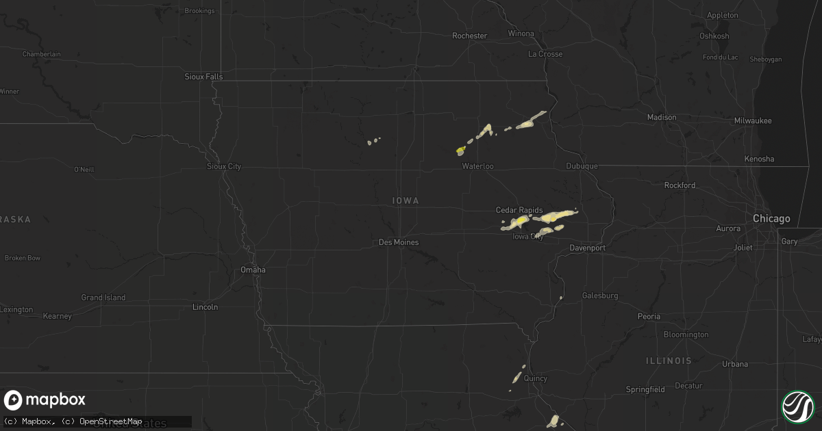
Hail Map in Iowa on May 29, 2019
Get this storm
May 29 map
$229
one time, instant access
Download today. No call, no setup
Keep the $229
Bought the map and want the full workflow? Apply the entire $229 to a subscription within 7 days. None of it is wasted.
Every map, not just this one
This buys you this map. Subscription and you get every map we run, in the markets you choose from a few cities to whole states to nationwide. Plus real-time alerts the moment a storm fires.
Contact data
Name, contact info, occupancy, even credit band for addresses in the footprint. You go from where it hit to who to call.
Become the source they trust
Unlimited branding weather history reports on demand. You already have the documented answer ready for the property owner, and you are the one who showed up with it.
Property data and RoofTrace estimates
Pull up any address you have got, its value and the exact code rules for that jurisdiction, straight from One Click Code. Then RoofTrace estimates the squares, pitch, and roof value, priced the way you price.
Storm reports in Iowa
Iowa
| Date | Description |
|---|---|
| 05/29/20196:23 PM CDT | A brief ef-0 tornado was captured by the public on video just southeast of victor. The tornado remained in open fields and no damage was observed. The duration of the t |
| 05/29/20196:22 PM CDT | Cone tornado reported. Report via social media. |
| 05/29/20195:01 PM CDT | Tornado has since dissipated. Spotter network report and via social media. |
| 05/29/20194:57 PM CDT | A local report indicates a tornado near 3 N POCAHONTAS |
| 05/29/20194:49 PM CDT | Landspout tornado. Report from social media. |
| 05/29/20193:58 PM CDT | Brief... Weak tornado. Photo via social media. |
| 05/29/20196:26 AM CDT | At 1126 PM CDT, a severe thunderstorm was located near Waucoma, or 12 miles east of New Hampton, moving northeast at 25 mph. HAZARD...Quarter size hail. SOURCE...Radar indicated. IMPACT...Damage to vehicles is expected. This severe thunderstorm will be near... Lawler around 1135 PM CDT. Waucoma around 1140 PM CDT. Fort Atkinson around 1155 PM CDT. Calmar and Spillville around 1200 AM CDT.Other locations impacted by this severe thunderstorm include CountyRoads B 54 And V 56, Waucoma Campground, Festina, Jackson Junction,Lake Meyer County Park, Alpha and Richfield. |
| 05/29/20195:37 AM CDT | At 1037 PM CDT, a severe thunderstorm was located over Welton, or 12 miles south of Maquoketa, moving east at 40 mph. HAZARD...70 mph wind gusts. SOURCE...Radar indicated. IMPACT...Expect considerable tree damage. Damage is likely to mobile homes, roofs, and outbuildings. Locations impacted include... Clinton, DeWitt, Camanche, Fulton, Grand Mound, Delmar, Lost Nation, Calamus, Charlotte, Low Moor, Welton, Andover, Goose Lake, Bryant, Lyons, Malone, Bulgers Hollow, Teeds Grove, Elvira and Camp Miss-Elk-Ton. |
| 05/29/20195:30 AM CDT | At 1029 PM CDT, a severe thunderstorm was located over Waverly, moving northeast at 20 mph. HAZARD...Quarter size hail. SOURCE...Radar indicated. IMPACT...Damage to vehicles is expected. Locations impacted include... Waverly and Waverly Municipal Airport. |
| 05/29/20195:09 AM CDT | At 1009 PM CDT, a severe thunderstorm was located over Toronto, or 12 miles east of Stanwood, moving east at 20 mph. HAZARD...60 mph wind gusts. SOURCE...Trained weather spotters. IMPACT...Expect damage to roofs, siding, and trees. Locations impacted include... DeWitt, Lowden, Wheatland, Grand Mound, Delmar, Oxford Junction, Lost Nation, Calamus, Welton, Toronto, Massillon Park, Oxford Mills, Elwood, Walnut Grove Park and Clinton County Fairgrounds. |
| 05/29/20194:00 AM CDT | At 900 PM CDT, severe thunderstorms were located along a line extending from Martelle to 6 miles north of West Branch to Hills, moving east at 25 mph. HAZARD...60 mph wind gusts and quarter size hail. SOURCE...Radar indicated. IMPACT...Hail damage to vehicles is expected. Expect wind damage to roofs, siding, and trees. Locations impacted include... Iowa City, Tipton, West Branch, Mechanicsville, Stanwood, Coralville, North Liberty, Mount Vernon, Lisbon, Solon, Springville, University Heights, Lowden, Hills, Olin, Wyoming, Oxford Junction, Bennett, Martelle and Onslow.This includes Interstate 80 in Iowa between mile markers 241 and 276. |
| 05/28/201910:36 PM CDT | Corrects previous hail report from waverly. |
| 05/28/20199:58 PM CDT | Large 24 inch diameter tree down. Time estimated based on radar. |
| 05/28/20199:38 PM CDT | Several large tree limbs down in stanwood. Largest is 14 inches in diameter and is on a home and power lines. Time estimated based on radar. |
| 05/28/20199:10 PM CDT | Report relayed via law enforcement. |
| 05/28/20198:35 PM CDT | A local report indicates a tornado near 1 SSW ELDORA |
| 05/28/20198:30 PM CDT | Roof torn from barn structure. |
| 05/28/20198:20 PM CDT | Several reports from law enforcement and trained spotters of a tornado touchdown north of kalona and south of frytown. |
| 05/28/20197:46 PM CDT | Emergency management observed a weak ef-0 tornado develop east of guernsey... And follow an intermittent path about 3 miles to the northeast before lifting just south o |
| 05/28/20197:43 PM CDT | Possible tornado touch down. Time estimated using radar. |
| 05/28/20197:39 PM CDT | Reported still on the ground toward 470th st. |
| 05/28/20197:28 PM CDT | Tornado had lifted... Now back on the ground. |
| 05/28/20197:18 PM CDT | ***1 injury*** injury reported at a previous farmstead with damage. Damage to an outbuilding... Tornado had lifted and was back on the ground. |
| 05/28/20197:12 PM CDT | Debris reported from tornado. |
| 05/28/20197:06 PM CDT | Tornado damage reported near the farmstead. |
| 05/28/20197:05 PM CDT | Tornado damage to power lines reported at 175th st and 520th ave. |
| 05/28/20197:03 PM CDT | Tornado touchdown with debris rotation at the ground. |
All States Impacted by Hail Map on May 29, 2019
Cities Impacted by Hail Map on May 29, 2019
- Seth, WV
- Danville, WV
- Madison, WV
- Ada, OK
- Trent, TX
- Sweetwater, TX
- Merkel, TX
- Hawley, TX
- Abilene, TX
- Germansville, PA
- Lehighton, PA
- Andreas, PA
- Horsham, PA
- Huntingdon Valley, PA
- Ambler, PA
- Hatboro, PA
- Willow Grove, PA
- Dresher, PA
- Perrin, TX
- Weatherford, TX
- Graford, TX
- Mineral Wells, TX
- Waverly, KY
- Morganfield, KY
- Clinton, AR
- Stroudsburg, PA
- Long Pond, PA
- Pocono Lake, PA
- Blakeslee, PA
- Hardy, AR
- Cherokee Village, AR
- Ash Flat, AR
- Okmulgee, OK
- Princeton, NJ
- Ezel, KY
- West Liberty, KY
- Lexington, VA
- Glasgow, VA
- Natural Bridge, VA
- Nathalie, VA
- Doylestown, PA
- Pipersville, PA
- Lumberville, PA
- New Hope, PA
- Hulbert, OK
- Sumner, IA
- Fredericksburg, IA
- Waverly, IA
- Tripoli, IA
- Wilsondale, WV
- Chapmanville, WV
- Dingess, WV
- Harts, WV
- Breeden, WV
- Tulsa, OK
- Broken Arrow, OK
- Macungie, PA
- Zionsville, PA
- Breinigsville, PA
- Kutztown, PA
- Emmaus, PA
- Mertztown, PA
- Quakertown, PA
- Richlandtown, PA
- Coopersburg, PA
- Alburtis, PA
- Topton, PA
- Trenton, NJ
- Crofton, KY
- Carversville, PA
- Perkasie, PA
- Ottsville, PA
- Breckenridge, TX
- Caddo, TX
- Azle, TX
- Springtown, TX
- Haskell, OK
- Seco, KY
- Haysi, VA
- Vansant, VA
- McRoberts, KY
- Grundy, VA
- Neon, KY
- Shelby Gap, KY
- Jackhorn, KY
- Jenkins, KY
- Clintwood, VA
- Whitesburg, KY
- Pound, VA
- Millstone, KY
- Clinchco, VA
- Ellington, MO
- Piedmont, MO
- Drasco, AR
- Concord, AR
- Mountain View, AR
- Higden, AR
- Prim, AR
- Princeton, KY
- Cerulean, KY
- Ozona, TX
- Bland, MO
- Belle, MO
- Russellville, KY
- Morgantown, KY
- Lewisburg, KY
- Bowling Green, KY
- Rockfield, KY
- Gretna, VA
- Hurt, VA
- Long Island, VA
- Kansas, IL
- Casey, IL
- Westfield, IL
- Martinsville, IL
- Ashmore, IL
- Postville, IA
- Coahoma, TX
- Big Spring, TX
- Siloam Springs, AR
- Gentry, AR
- Palmerton, PA
- Flat Top, WV
- Jumping Branch, WV
- De Queen, AR
- Roscoe, TX
- Loraine, TX
- Colorado City, TX
- Ennis, TX
- Cairo, IL
- Charleston, MO
- Albany, TX
- Blossom, TX
- Detroit, TX
- Paris, TX
- Goldsmith, TX
- Woodson, TX
- Throckmorton, TX
- Bangor, PA
- Hopewell, NJ
- Lambertville, NJ
- Pennington, NJ
- Myerstown, PA
- Gilbertsville, PA
- Boyertown, PA
- Perkiomenville, PA
- Zieglerville, PA
- Birdsboro, PA
- Douglassville, PA
- Oley, PA
- Womelsdorf, PA
- Temple, PA
- Telford, PA
- Leesport, PA
- Mohrsville, PA
- Robesonia, PA
- Reading, PA
- Schwenksville, PA
- Pottstown, PA
- Frederick, PA
- Richland, PA
- Bernville, PA
- Green Lane, PA
- Wernersville, PA
- Harleysville, PA
- Powersite, MO
- Kirbyville, MO
- Branson, MO
- Forsyth, MO
- Hollister, MO
- Kresgeville, PA
- Kunkletown, PA
- Blue Creek, OH
- Lynx, OH
- West Union, OH
- Stout, OH
- Annapolis, MO
- Fredericktown, MO
- Narrows, VA
- Warminster, PA
- Southampton, PA
- Six Mile Run, PA
- Hopewell, PA
- Gunter, TX
- Pilot Point, TX
- Tipton, IA
- Bennett, IA
- Clarence, IA
- Bloomsburg, PA
- Sugarloaf, PA
- Nescopeck, PA
- Rock Glen, PA
- Hume, IL
- Metcalf, IL
- Chrisman, IL
- Brocton, IL
- Patriot, OH
- Crown City, OH
- Cleveland, AR
- Scotland, AR
- Leonard, TX
- Dodd City, TX
- Honey Grove, TX
- Windom, TX
- Wolfe City, TX
- Ladonia, TX
- Bonham, TX
- Brackettville, TX
- Annville, PA
- Lebanon, PA
- North Henderson, IL
- Rio, IL
- Houston, AR
- Cisco, TX
- Richfield, PA
- McAlisterville, PA
- Cocolamus, PA
- Millerstown, PA
- McClure, PA
- Monona, IA
- Tuscarora, PA
- Barnesville, PA
- Tamaqua, PA
- Brockton, PA
- Nimitz, WV
- Hinton, WV
- Bentonville, AR
- Springdale, AR
- Alvaton, KY
- Saylorsburg, PA
- Effort, PA
- Brodheadsville, PA
- Lake Harmony, PA
- Sciota, PA
- Jim Thorpe, PA
- Albrightsville, PA
- Mount Vernon, IN
- Corning, AR
- Knobel, AR
- Delaplaine, AR
- Paragould, AR
- Peach Orchard, AR
- Oak Hill, OH
- Beaver, OH
- South Webster, OH
- Minford, OH
- Jackson, OH
- Lucasville, OH
- Java, VA
- Mary D, PA
- Knott, TX
- Stanton, TX
- Bergheim, TX
- Spring Branch, TX
- Kendalia, TX
- Fancy Farm, KY
- Tioga, TX
- Celina, TX
- Collinsville, TX
- Mansfield, TX
- Kennedale, TX
- Arlington, TX
- Del Rio, TX
- Graham, TX
- Grand Saline, TX
- Mulberry Grove, IL
- Paris, IL
- Manchester, KY
- Swisher, IA
- Rebersburg, PA
- Loganton, PA
- Mifflinburg, PA
- Mill Hall, PA
- Proctor, OK
- Tahlequah, OK
- Burlington, IA
- Milford, VA
- Harrison, AR
- Omaha, AR
- Porter, OK
- Carthage, IL
- Mineola, TX
- Jackson, MO
- Kemp, TX
- Stanwood, IA
- Mechanicsville, IA
- Oxford Junction, IA
- Lost Nation, IA
- Lowden, IA
- Wheatland, IA
- Moran, TX
- Patterson, MO
- Hot Springs National Park, AR
- Kissee Mills, MO
- Blue Eye, MO
- Lampe, MO
- Reeds Spring, MO
- Gardendale, TX
- Odessa, TX
- Midland, TX
- Ozark, AR
- West Branch, IA
- Iowa City, IA
- Pursglove, WV
- Morgantown, WV
- Blacksville, WV
- Wana, WV
- Maidsville, WV
- Fairview, WV
- Burton, WV
- Pittsfield, IL
- Hermleigh, TX
- Hamburg, PA
- Lenhartsville, PA
- Shoemakersville, PA
- Bowen, IL
- La Prairie, IL
- Augusta, IL
- Vichy, MO
- Saint Louis, MO
- Big Rock, VA
- Hurley, VA
- Gillham, AR
- McVeytown, PA
- Mount Union, PA
- Mapleton Depot, PA
- Mill Creek, PA
- Middle River, MD
- Gunpowder, MD
- Rosedale, MD
- Essex, MD
- Towson, MD
- White Marsh, MD
- Randallstown, MD
- Perry Hall, MD
- Pikesville, MD
- Nottingham, MD
- Parkville, MD
- Gwynn Oak, MD
- Baltimore, MD
- Windsor Mill, MD
- Teutopolis, IL
- Altamont, IL
- Shumway, IL
- Effingham, IL
- Sigel, IL
- Watson, IL
- Wheeler, IL
- Sparks, OK
- Meeker, OK
- Bethany, IL
- Sullivan, IL
- Cape Charles, VA
- Inez, KY
- Tomahawk, KY
- Pilgrim, KY
- Debord, KY
- Elkton, KY
- Greenville, KY
- Shawnee, OK
- Tecumseh, OK
- Hopkinsville, KY
- Danville, PA
- Salyersville, KY
- Thompsontown, PA
- Mifflintown, PA
- Eureka Springs, AR
- Northampton, PA
- New Tripoli, PA
- Laurys Station, PA
- Gilberton, PA
- Hellertown, PA
- Slatedale, PA
- Bethlehem, PA
- Bath, PA
- Coplay, PA
- Asbury, NJ
- Walnutport, PA
- Allentown, PA
- Phillipsburg, NJ
- Shenandoah, PA
- Milford, NJ
- New Ringgold, PA
- Stewartsville, NJ
- Mahanoy City, PA
- New Philadelphia, PA
- Slatington, PA
- Mahanoy Plane, PA
- Bloomsbury, NJ
- Easton, PA
- Nazareth, PA
- Phoenix, MD
- Taft, OK
- Colcord, OK
- Wagoner, OK
- Westville, OK
- Okemah, OK
- Coweta, OK
- Muskogee, OK
- Henryetta, OK
- Wetumka, OK
- Boley, OK
- Kansas, OK
- Bristow, OK
- Watts, OK
- Castle, OK
- Morris, OK
- Fort Gibson, OK
- Weleetka, OK
- Hardeeville, SC
- Sonora, TX
- Flemington, NJ
- Ringoes, NJ
- Annapolis, IL
- Goldfield, IA
- Renwick, IA
- Chesterfield, MO
- Cobden, IL
- Holdenville, OK
- Edgewood, TX
- Fruitvale, TX
- Canton, TX
- Mabank, TX
- Alba, TX
- Wills Point, TX
- Checotah, OK
- Eufaula, OK
- Richland Center, WI
- Aledo, IL
- Reynolds, IL
- Carman, IL
- Claremore, OK
- Catoosa, OK
- Owasso, OK
- Rhome, TX
- Eldorado, TX
- White Plains, KY
- Pea Ridge, AR
- Rogers, AR
- Saltville, VA
- Saint Joe, AR
- Marshall, AR
- New Richmond, OH
- California, KY
- Winnsboro, TX
- Hardy, IA
- Humboldt, IA
- Healdton, OK
- Westbrook, TX
- Elgin, IA
- East Stroudsburg, PA
- Hazel Green, KY
- Campton, KY
- Des Arc, MO
- Fort Worth, TX
- Keller, TX
- Ely, IA
- Cedar Rapids, IA
- Solon, IA
- Herndon, WV
- Matoaka, WV
- Lashmeet, WV
- Oblong, IL
- Yale, IL
- Gallipolis, OH
- New Egypt, NJ
- Lakehurst, NJ
- Prue, OK
- Mount Judea, AR
- Dunmor, KY
- Benton, AR
- Santo, TX
- Palo Pinto, TX
- Altoona, PA
- Tyrone, PA
- Stuart, VA
- Bassett, VA
- Henry, VA
- Ferrum, VA
- Richmond, KY
- Poolville, TX
- North Richland Hills, TX
- Southlake, TX
- Scranton, AR
- Bastrop, TX
- Independence, VA
- Fries, VA
- Cripple Creek, VA
- Ivanhoe, VA
- Bridgeton, MO
- Saint Charles, MO
- Earth City, MO
- Maryland Heights, MO
- Guthrie, KY
- Telephone, TX
- Ocotillo, CA
- Julian, WV
- Foster, WV
- Peytona, WV
- Ridgeview, WV
- Costa, WV
- Ryan, OK
- Ringling, OK
- Ewing, MO
- Durham, MO
- Maywood, MO
- Philadelphia, MO
- Hidalgo, IL
- Penelope, TX
- Science Hill, KY
- Somerset, KY
- Bowling Green, MO
- Louisiana, MO
- Partridge, KY
- Paden, OK
- Larue, TX
- Athens, TX
- Eddyville, KY
- Quitman, TX
- Olin, IA
- Belton, KY
- Lavaca, AR
- Fort Smith, AR
- Cooper, TX
- Davis, OK
- Wynnewood, OK
- Pikeville, KY
- Oneida, KY
- Baird, TX
- Mount Vernon, IA
- Lexington, OK
- Eldred, IL
- Carrollton, IL
- Saint Peters, MO
- O'Fallon, MO
- Pennsburg, PA
- Thayer, MO
- Wanette, OK
- Jacksboro, TX
- Bryson, TX
- Fieldon, IL
- Appalachia, VA
- Deer, AR
- Hagarville, AR
- Clarksville, AR
- Ozone, AR
- Galax, VA
- Woodlawn, VA
- Fairbanks, IN
- Edgemont, AR
- Cumberland, VA
- Pleasant Hill, IL
- Basco, IL
- Piasa, IL
- Shipman, IL
- Medora, IL
- Mount Olive, IL
- Nortonville, KY
- Saint Charles, KY
- Center Ridge, AR
- Springfield, AR
- Kaufman, TX
- Aledo, TX
- Prestonsburg, KY
- Van Lear, KY
- East Point, KY
- Hagerhill, KY
- Auxier, KY
- Davy, WV
- Washington Crossing, PA
- Morrisville, PA
- Essex, MO
- Wilson, OK
- Eustace, TX
- Lansdale, PA
- Line Lexington, PA
- Hilltown, PA
- Hatfield, PA
- Colmar, PA
- Chalfont, PA
- Liberty, KY
- Defiance, MO
- Crowley, TX
- Bedford, TX
- Colleyville, TX
- Hurst, TX
- Haltom City, TX
- Naval Air Station Jrb, TX
- Roanoke, TX
- Euless, TX
- Haslet, TX
- Heber Springs, AR
- Lewes, DE
- Fredericksburg, PA
- Bethel, PA
- Bixby, OK
- Beggs, OK
- Mounds, OK
- Auburn, KY
- Locust Grove, AR
- Richardson, TX
- Dallas, TX
- Fort Loudon, PA
- Mercersburg, PA
- Saint Thomas, PA
- Chambersburg, PA
- Titusville, NJ
- Stockton, NJ
- Worton, MD
- Montrose, IL
- Lewistown, PA
- Mount Pleasant Mills, PA
- Saint Ann, MO
- Forest Hill, MD
- Fallston, MD
- Crewe, VA
- Jackson, KY
- Jonestown, PA
- Beeson, WV
- Rock, WV
- Locust Grove, OK
- Chandler, OK
- Woodburn, KY
- Speedwell, VA
- Wytheville, VA
- Bigelow, AR
- Perryville, AR
- Morrilton, AR
- Perry, AR
- Frenchburg, KY
- Salt Lick, KY
- Wingo, KY
- Nilwood, IL
- Carlinville, IL
- Franklin, AR
- Rush Springs, OK
- Saxton, PA
- Newport, PA
- New Bloomfield, PA
- Elliottsburg, PA
- Nashville, IN
- Columbus, IN
- Robbinsville, NJ
- Princeton Junction, NJ
- Lawrence Township, NJ
- Poplar Bluff, MO
- Jackson, NJ
- Freehold, NJ
- Silverdale, PA
- Fountainville, PA
- Newtown, PA
- Bechtelsville, PA
- Warrington, PA
- Dublin, PA
- Souderton, PA
- Red Hill, PA
- Point Pleasant, PA
- Furlong, PA
- Sellersville, PA
- Trumbauersville, PA
- Richboro, PA
- Fleetwood, PA
- Jamison, PA
- East Greenville, PA
- Strawn, TX
- California, MO
- Wind Ridge, PA
- Aleppo, PA
- Holbrook, PA
- Searcy, AR
- Romance, AR
- Henrietta, TX
- Belfry, KY
- Sidney, KY
- Litchfield, IL
- Alma, AR
- Mulberry, AR
- Luana, IA
- Clermont, IA
- Shirley, AR
- Sikeston, MO
- Scotrun, PA
- Tannersville, PA
- Pocono Pines, PA
- Livermore, KY
- Windsor, PA
- Red Lion, PA
- Brogue, PA
- Felton, PA
- Wharton, WV
- Sumner, TX
- Brookston, TX
- Witts Springs, AR
- Bourbon, MO
- Miami, OK
- Dalton City, IL
- Macon, IL
- Findlay, IL
- Moweaqua, IL
- Fayetteville, AR
- Gravelly, AR
- Harvey, AR
- West York, IL
- Greenup, IL
- West Union, IL
- Kuttawa, KY
- Grand Rivers, KY
- Imboden, AR
- Black Rock, AR
- Owingsville, KY
- Gideon, MO
- Portageville, MO
- Saint Francis, KY
- Loretto, KY
- Allen, KY
- Langley, KY
- Martin, KY
- David, KY
- Gunlock, KY
- Hueysville, KY
- Printer, KY
- Hegins, PA
- Sacramento, PA
- Spring Glen, PA
- Blue Mound, IL
- Savoy, TX
- Oxford, IA
- Amana, IA
- Utica, KY
- Hartford, KY
- Goodview, VA
- Vinton, VA
- Moneta, VA
- Chaffee, MO
- Henderson, KY
- Reedy, WV
- Elkfork, KY
- Farmville, VA
- Sand Springs, OK
- Cleveland, OK
- Cedar Bluff, VA
- Hillsborough, NJ
- Dolph, AR
- Elizabeth, AR
- Bexar, AR
- Viola, AR
- Shell Rock, IA
- Paint Lick, KY
- Berea, KY
- Clyde, TX
- Heltonville, IN
- Bedford, IN
- Penhook, VA
- Martinsville, VA
- Rocky Mount, VA
- Sapulpa, OK
- Kellyville, OK
- Kiefer, OK
- Olmstead, KY
- Allensville, KY
- West Point, IL
- Loraine, IL
- Charleston, IL
- Talala, OK
- Oxford, PA
- Kirkwood, PA
- Solgohachia, AR
- Ravenna, TX
- Ivanhoe, TX
- Brownsboro, TX
- Murchison, TX
- Centerton, AR
- Boerne, TX
- Vinton, OH
- Thurman, OH
- Rio Grande, OH
- Gallipolis Ferry, WV
- Bidwell, OH
- Fallentimber, PA
- Blandburg, PA
- Hickman, KY
- Marston, MO
- Lilbourn, MO
- Winchester, OH
- Seaman, OH
- Geff, IL
- Chesterfield, NJ
- Gwynedd, PA
- Bordentown, NJ
- Bensalem, PA
- Palmyra, PA
- Barto, PA
- Fort Washington, PA
- Roebling, NJ
- Collegeville, PA
- Blue Bell, PA
- Hershey, PA
- Bryn Athyn, PA
- Fairless Hills, PA
- Hummelstown, PA
- Feasterville Trevose, PA
- Norristown, PA
- Skippack, PA
- Jenkintown, PA
- Bally, PA
- Bristol, PA
- Langhorne, PA
- Windsor, NJ
- Ono, PA
- Florence, NJ
- Harrisburg, PA
- Burlington, NJ
- Columbus, NJ
- Grantville, PA
- Shartlesville, PA
- North Wales, PA
- Allentown, NJ
- Philadelphia, PA
- Roosevelt, NJ
- Abington, PA
- Hightstown, NJ
- Montgomeryville, PA
- Millstone Township, NJ
- Levittown, PA
- Palm, PA
- Howell, NJ
- Spring House, PA
- Cream Ridge, NJ
- Nancy, KY
- Windsor, KY
- Bethelridge, KY
- Eubank, KY
- New Douglas, IL
- Alhambra, IL
- Shelbiana, KY
- Raccoon, KY
- Phyllis, KY
- Subiaco, AR
- Petty, TX
- La Grange, MO
- London, TX
- McConnellsburg, PA
- Howe, TX
- Temple, TX
- Tresckow, PA
- Junedale, PA
- Hazleton, PA
- Wewoka, OK
- Latham, MO
- Pomeroy, OH
- Rutland, OH
- Racine, OH
- Middleport, OH
- Beaver, WV
- Daniels, WV
- Drums, PA
- Wapwallopen, PA
- Mountain Top, PA
- Ranger, TX
- Delmar, IA
- Lisbon, IA
- Saint Elmo, IL
- Story, AR
- White Haven, PA
- Freeland, PA
- Seaton, IL
- Oquawka, IL
- Rousseau, KY
- Bradfordsville, KY
- Elk Horn, KY
- Floral, AR
- Malakoff, TX
- Pennsauken, NJ
- Elkins Park, PA
- Camden, NJ
- Palmyra, NJ
- Cherry Hill, NJ
- Riverton, NJ
- Merchantville, NJ
- Moorestown, NJ
- Cheltenham, PA
- Maple Shade, NJ
- Liverpool, PA
- Millersburg, PA
- Maud, OK
- Asher, OK
- Arthur City, TX
- Hardy, VA
- Prague, OK
- Harrah, OK
- Mcloud, OK
- Marengo, IA
- Homestead, IA
- South Amana, IA
- North Liberty, IA
- Fairfax, IA
- Berwick, PA
- Orangeville, PA
- Ravenden, AR
- Norton, VA
- Cape Girardeau, MO
- Berryville, AR
- Taneyville, MO
- Mouthcard, KY
- Steele, KY
- Cookstown, NJ
- Lakewood, NJ
- Joint Base Mdl, NJ
- Wrightstown, NJ
- Jobstown, NJ
- Manchester Township, NJ
- Toms River, NJ
- Bee Branch, AR
- Quitman, AR
- Ben Wheeler, TX
- Welling, OK
- Earlsboro, OK
- Booneville, KY
- Dalmatia, PA
- Elizabethville, PA
- Berrysburg, PA
- Vincennes, IN
- Robards, KY
- Corydon, KY
- Horseshoe Bend, AR
- Newalla, OK
- Pauls Valley, OK
- New Hartford, IA
- Philpot, KY
- Melvin, KY
- Bypro, KY
- Bevinsville, KY
- Beaver, KY
- Weeksbury, KY
- Virgie, KY
- Wheelwright, KY
- Robinson Creek, KY
- Pawnee, OK
- Maramec, OK
- Hominy, OK
- Amherstdale, WV
- Naoma, WV
- Pineville, WV
- Evansville, IN
- Sharon Grove, KY
- Pembroke, KY
- Trenton, KY
- Purdon, TX
- Trenton, TX
- Winters, TX
- Marcella, AR
- Batesville, AR
- Beecher City, IL
- Bell City, MO
- Tumbling Shoals, AR
- Paoli, OK
- Saint Olaf, IA
- Marion, VA
- Meadowview, VA
- Lincoln, AR
- Stratford, OK
- Couch, MO
- Owensboro, KY
- Fredonia, KY
- Theodosia, MO
- Hodgen, OK
- Hesston, PA
- Williamsburg, PA
- Huntingdon, PA
- Loysburg, PA
- New Enterprise, PA
- Woodbury, PA
- Spencer, WV
- Bryant, AR
- Summersville, WV
- Calhoun, KY
- Wadesville, IN
- Winona, MO
- Cadiz, KY
- Gracey, KY
- East Liverpool, OH
- Barlow, KY
- Woolwine, VA
- Dyess Afb, TX
- Tye, TX
- Mingus, TX
- Gordon, TX
- Atoka, OK
- Irving, TX
- Carrollton, TX
- Clarksville, MO
- Carrollton, OH
- Campbellsville, KY
- Mount Pleasant, AR
- Hennepin, OK
- Duncannon, PA
- Halifax, PA
- Amelia Court House, VA
- Greenville, TX
- Damascus, AR
- Emden, MO
- Monroe City, MO
- Trinidad, TX
- Saint Albans, MO
- Wildwood, MO
- Ballwin, MO
- Pacific, MO
- Mayfield, KY
- Gainesville, MO
- Sebree, KY
- Mifflinville, PA
- Zion Grove, PA
- Owensville, MO
- Terrell, TX
- Divernon, IL
- Virden, IL
- Grethel, KY
- Harold, KY
- Chilhowie, VA
- Glade Spring, VA
- Lebanon, VA
- Abingdon, VA
- Glenpool, OK
- Springer, OK
- Macomb, OK
- Protem, MO
- McLeansboro, IL
- Lake Creek, TX
- Rosebud, TX
- Auburn, PA
- Schuylkill Haven, PA
- La Center, KY
- Kevil, KY
- Pineville, AR
- Hawkeye, IA
- West Union, IA
- Fayette, IA
- Golden, MO
- Cassville, MO
- Orbisonia, PA
- Dysart, PA
- Bellwood, PA
- McClure, VA
- Eolia, KY
- Oakwood, VA
- Milford, DE
- Rockport, IL
- Dille, WV
- Clay, WV
- Krum, TX
- Decatur, TX
- Ponder, TX
- Mohnton, PA
- Weatherly, PA
- Lebanon, NJ
- East Prairie, MO
- Beech Grove, AR
- Rhodell, WV
- Odd, WV
- Josephine, WV
- Waterville, IA
- Harpers Ferry, IA
- Waynesburg, PA
- Athens, WV
- Lerona, WV
- Princeton, WV
- Atkins, VA
- Chatham, IL
- Prairie Grove, AR
- Stroud, OK
- Woodbine, MD
- Sykesville, MD
- Mount Airy, MD
- Peebles, OH
- Otway, OH
- Chatfield, TX
- Plymouth, IL
- West Liberty, IL
- Byars, OK
- Isom, KY
- Jeremiah, KY
- Premium, KY
- Brookneal, VA
- Lafe, AR
- Fredericksburg, TX
- Mount Vernon, KY
- McKee, KY
- Orlando, KY
- Dawson Springs, KY
- Hanna, OK
- Dustin, OK
- Cyclone, WV
- Wayland, KY
- Flower Mound, TX
- Oran, MO
- Harviell, MO
- Neelyville, MO
- Fairfield Bay, AR
- Eagletown, OK
- Richland, TX
- Thermal, CA
- Farmingdale, NJ
- Brick, NJ
- Heavener, OK
- Bragg City, MO
- Wardell, MO
- Beech Creek, PA
- Blanchard, PA
- Jerseyville, IL
- Fidelity, IL
- Eastman, WI
- Fountaintown, IN
- Fort Towson, OK
- Enloe, TX
- Roxton, TX
- Klondike, TX
- Coeburn, VA
- Nora, VA
- Bartonsville, PA
- Corsicana, TX
- Beach City, OH
- Alexander, AR
- Millsap, TX
- Whitt, TX
- Pen Argyl, PA
- Gilbert, PA
- Mendon, IL
- Griggsville, IL
- Greenwood, AR
- Lamar, OK
- Brooklyn, MD
- Means, KY
- Olympia, KY
- Camp Creek, WV
- Spanishburg, WV
- Newark, TX
- Kimberling City, MO
- Lewisburg, PA
- Trexlertown, PA
- Center Valley, PA
- Kintnersville, PA
- Frackville, PA
- Locust Gap, PA
- Mount Carmel, PA
- Coal Township, PA
- Ringtown, PA
- Kulpmont, PA
- Girardville, PA
- Ashland, PA
- Shamokin, PA
- Wilburton, PA
- Honey Grove, PA
- East Waterford, PA
- Catawissa, PA


