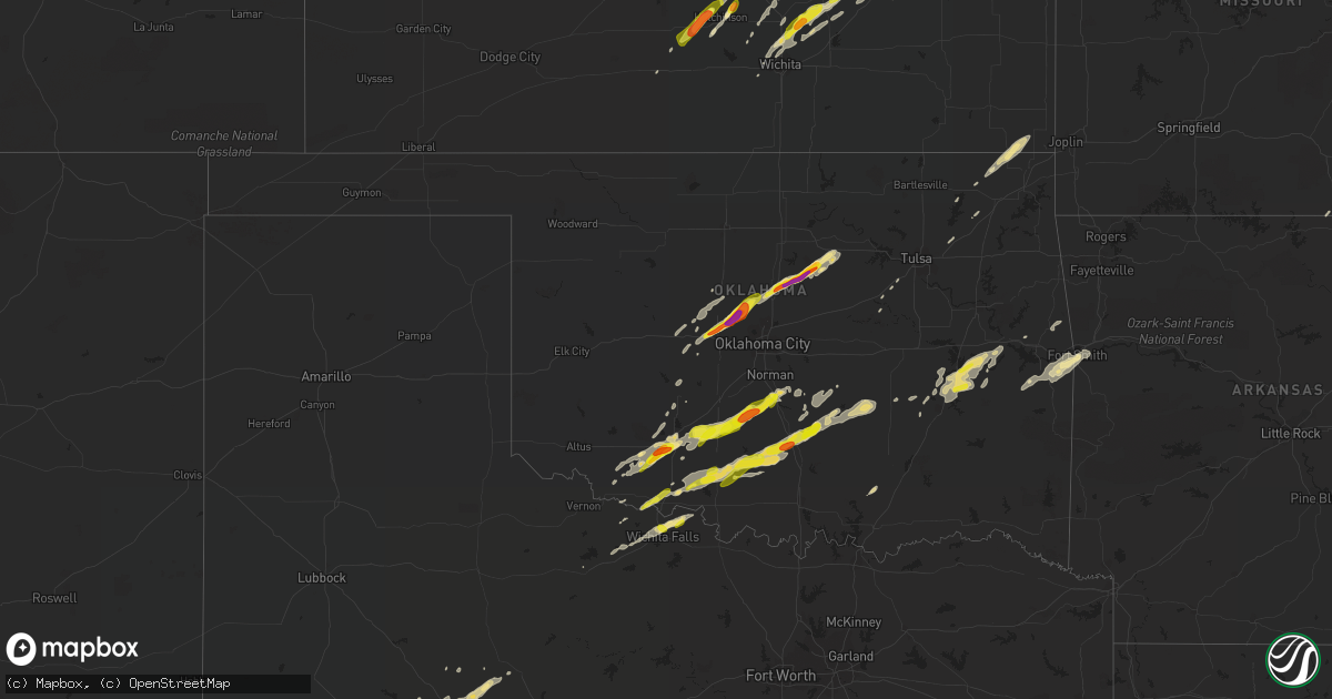
Hail Map in Oklahoma on May 28, 2019
Get this storm
May 28 map
$229
one time, instant access
Download today. No call, no setup
Keep the $229
Bought the map and want the full workflow? Apply the entire $229 to a subscription within 7 days. None of it is wasted.
Every map, not just this one
This buys you this map. Subscription and you get every map we run, in the markets you choose from a few cities to whole states to nationwide. Plus real-time alerts the moment a storm fires.
Contact data
Name, contact info, occupancy, even credit band for addresses in the footprint. You go from where it hit to who to call.
Become the source they trust
Unlimited branding weather history reports on demand. You already have the documented answer ready for the property owner, and you are the one who showed up with it.
Property data and RoofTrace estimates
Pull up any address you have got, its value and the exact code rules for that jurisdiction, straight from One Click Code. Then RoofTrace estimates the squares, pitch, and roof value, priced the way you price.
Storm reports in Oklahoma
Oklahoma
| Date | Description |
|---|---|
| 05/28/20196:59 PM CDT | A local report indicates 60 MPH wind near 8 N COGAR |
| 05/28/20196:56 PM CDT | A local report indicates 1.00 inch wind near GUTHRIE |
| 05/28/20196:42 PM CDT | A local report indicates 1.00 inch wind near 4 S RUSH SPRINGS |
| 05/28/20196:40 PM CDT | Trees down. Time based on radar. |
| 05/28/20196:11 PM CDT | Homestead and cache in nw lawton. |
| 05/28/20196:07 PM CDT | Se 38th and cache. Time estimated from radar |
| 05/28/20196:04 PM CDT | Social media report with picture. |
| 05/28/20196:02 PM CDT | A local report indicates 1.50 inch wind near 3 WNW LAWTON |
| 05/28/20195:58 PM CDT | Car damage and broken windows from hail. Twitter report with pictures. Time from radar. |
| 05/28/20195:57 PM CDT | A local report indicates 2.00 inch wind near 6 ENE CONCHO |
| 05/28/20195:47 PM CDT | Social media message. |
| 05/28/20195:46 PM CDT | 62nd and nw compass in lawton |
| 05/28/20195:45 PM CDT | A local report indicates 1.00 inch wind near 1 SW LAWTON |
| 05/28/20195:40 PM CDT | A local report indicates 1.00 inch wind near 1 SW LAWTON |
| 05/28/20195:40 PM CDT | Social media report. |
| 05/28/20195:37 PM CDT | A local report indicates 1.75 inch wind near EL RENO |
| 05/28/20195:37 PM CDT | A local report indicates 1.00 inch wind near 4 WNW LAWTON |
| 05/28/20195:36 PM CDT | A local report indicates 1.75 inch wind near 2 N EL RENO |
| 05/28/20195:31 PM CDT | Corner of paint rd and tinney rd... A few ping pong ball size hailstones mixed in with half dollars. |
| 05/28/20196:28 AM CDT | At 1128 PM CDT, a severe thunderstorm was located 6 miles west of Byng, moving east at 40 mph. HAZARD...70 mph wind gusts and quarter size hail. SOURCE...Radar indicated. IMPACT...Hail damage to vehicles is expected. Expect considerable tree damage. Wind damage is also likely to mobile homes, roofs, and outbuildings. Locations impacted include... Ada, Holdenville, Wewoka, Stratford, Konawa, Byng, Allen, Francis, Sasakwa, Vanoss and Spaulding. |
| 05/28/20195:42 AM CDT | At 1042 PM CDT, a severe thunderstorm was located near Wynnewood, moving east at 30 mph. Another severe storm was located over Stratford moving east northeast at 35 mph. HAZARD...Golf ball size hail and 70 mph wind gusts. SOURCE...Radar indicated. IMPACT...People and animals outdoors will be injured. Expect hail damage to roofs, siding, windows, and vehicles. Expect considerable tree damage. Wind damage is also likely to mobile homes, roofs, and outbuildings. Locations impacted include... Ada, Pauls Valley, Wynnewood, Stratford, Konawa, Roff, Fitzhugh and Vanoss. |
| 05/28/20194:54 AM CDT | At 953 PM CDT, a severe thunderstorm was located near Katie, moving northeast at 30 mph. HAZARD...60 mph wind gusts and quarter size hail. SOURCE...Radar indicated. IMPACT...Hail damage to vehicles is expected. Expect wind damage to roofs, siding, and trees. Locations impacted include... Pauls Valley, Wynnewood, Stratford, Elmore City, Velma, Paoli, Katie, Foster, Tatums, Ratliff City, Antioch, Hennepin, Pernell and Whitebead. |
| 05/28/20194:09 AM CDT | At 908 PM CDT, a severe thunderstorm was located over Velma, moving east at 30 mph. This is a very dangerous storm. HAZARD...Baseball size hail and 70 mph wind gusts. SOURCE...Radar indicated. IMPACT...People and animals outdoors will be severely injured. Expect shattered windows, extensive damage to roofs, siding, and vehicles. Locations impacted include... Comanche, Elmore City, Velma, Katie, Foster, Tatums, Ratliff City, Hennepin, Pooleville, Antioch, Pernell and Fox. |
| 05/28/20193:30 AM CDT | At 830 PM CDT, a severe thunderstorm was located near Comanche, moving east at 25 mph. HAZARD...Ping pong ball size hail and 60 mph wind gusts. SOURCE...Radar indicated. IMPACT...People and animals outdoors will be injured. Expect hail damage to roofs, siding, windows, and vehicles. Expect wind damage to roofs, siding, and trees. Locations impacted include... Comanche, Velma, Loco, southeastern Waurika Lake and Empire City. |
| 05/28/20193:16 AM CDT | At 816 PM CDT, a severe thunderstorm was located near Temple, moving northeast at 20 mph. HAZARD...Ping pong ball size hail. SOURCE...Radar indicated. IMPACT...People and animals outdoors will be injured. Expect damage to roofs, siding, windows, and vehicles. Locations impacted include... Comanche, Temple, Hastings, Addington, Waurika Lake, Corum and Empire City. |
| 05/28/20192:41 AM CDT | At 741 PM CDT, a severe thunderstorm was located 4 miles northwest of Corum, moving northeast at 35 mph. HAZARD...60 mph wind gusts and quarter size hail. SOURCE...Radar indicated. IMPACT...Hail damage to vehicles is expected. Expect wind damage to roofs, siding, and trees. Locations impacted include... Duncan, Comanche, Bray, Velma, Corum, northwestern Waurika Lake and Empire City. |
| 05/28/20192:40 AM CDT | At 740 PM CDT, a severe thunderstorm was located 5 miles southeast of Stillwater, moving northeast at 35 mph. HAZARD...Golf ball size hail and 60 mph wind gusts. SOURCE...Trained weather spotters. IMPACT...People and animals outdoors will be injured. Expect hail damage to roofs, siding, windows, and vehicles. Expect wind damage to roofs, siding, and trees. Locations impacted include... Stillwater, Yale, Glencoe, Quay and Ingalls. |
| 05/28/20192:30 AM CDT | Emergency management reported about 100 homes without power in arkoma. Time estimated from radar. |
| 05/28/20192:28 AM CDT | At 728 PM CDT, a severe thunderstorm was located 6 miles northwest of Marlow, moving northeast at 35 mph. HAZARD...Ping pong ball size hail and 60 mph wind gusts. SOURCE...Radar indicated. IMPACT...People and animals outdoors will be injured. Expect hail damage to roofs, siding, windows, and vehicles. Expect wind damage to roofs, siding, and trees. Locations impacted include... Marlow, Lindsay, Maysville, Rush Springs, Dibble, Alex, Bradley, Criner, Central High, Acme, Payne, Cox City and Erin Springs. |
| 05/28/20192:26 AM CDT | At 726 PM CDT, a severe thunderstorm was located near Criner, moving northeast at 35 mph. HAZARD...Ping pong ball size hail and 60 mph wind gusts. SOURCE...Radar indicated. IMPACT...People and animals outdoors will be injured. Expect hail damage to roofs, siding, windows, and vehicles. Expect wind damage to roofs, siding, and trees. Locations impacted include... Southeastern Norman, Purcell, Noble, Slaughterville, Lexington, Pink, Goldsby, Dibble, Wayne, Washington, Asher, Tribbey, Wanette, Etowah, Brooksville, Macomb, Criner, southern Lake Thunderbird, Bethel Acres and Little Axe. |
| 05/28/20192:07 AM CDT | At 706 PM CDT, a severe thunderstorm was located near Coyle, moving northeast at 35 mph. HAZARD...Golf ball size hail and 60 mph wind gusts. SOURCE...Radar indicated. IMPACT...People and animals outdoors will be injured. Expect hail damage to roofs, siding, windows, and vehicles. Expect wind damage to roofs, siding, and trees. Locations impacted include... Stillwater, Cushing, Perkins, Glencoe, Ripley and Ingalls. |
| 05/28/20191:57 AM CDT | At 656 PM CDT, a severe thunderstorm was located near Alex, moving northeast at 30 mph. HAZARD...70 mph wind gusts and ping pong ball size hail. SOURCE...Radar indicated. IMPACT...People and animals outdoors will be injured. Expect hail damage to roofs, siding, windows, and vehicles. Expect considerable tree damage. Wind damage is also likely to mobile homes, roofs, and outbuildings. Locations impacted include... Pauls Valley, Purcell, Lindsay, Goldsby, Maysville, Rush Springs, Dibble, Washington, Paoli, Cole, Alex, Bradley, Agawam, Antioch, Criner, Payne, Cox City, Whitebead and Erin Springs. |
| 05/28/20191:12 AM CDT | At 611 PM CDT, a severe thunderstorm was located near Sterling, moving northeast at 45 mph. HAZARD...70 mph wind gusts and ping pong ball size hail. SOURCE...Radar indicated. IMPACT...People and animals outdoors will be injured. Expect hail damage to roofs, siding, windows, and vehicles. Expect considerable tree damage. Wind damage is also likely to mobile homes, roofs, and outbuildings. Locations impacted include... Northeastern Lawton, Chickasha, Marlow, Elgin, Rush Springs, Fletcher, Sterling, Alex, Norge, Bradley, Agawam, eastern Fort Sill, Tabler, Central High, Ninnekah, Acme and Cox City. |
| 05/28/201912:29 AM CDT | At 529 PM CDT, severe thunderstorms were located along a line extending from near Fort Sill to 4 miles north of Faxon, moving northeast at 25 mph. HAZARD...Ping pong ball size hail and 60 mph wind gusts. SOURCE...Radar indicated. IMPACT...People and animals outdoors will be injured. Expect hail damage to roofs, siding, windows, and vehicles. Expect wind damage to roofs, siding, and trees. Locations impacted include... Lawton, Duncan, Chickasha, Marlow, Cache, Elgin, Geronimo, Rush Springs, Bray, Fletcher, Cyril, Sterling, Cement, Medicine Park, Norge, Faxon, Agawam, Fort Sill, Lake Ellsworth and Central High. |
| 05/28/201912:26 AM CDT | At 526 PM CDT, a severe thunderstorm was located 4 miles west of El Reno, moving northeast at 35 mph. HAZARD...Golf ball size hail and 60 mph wind gusts. SOURCE...Radar indicated. IMPACT...People and animals outdoors will be injured. Expect hail damage to roofs, siding, windows, and vehicles. Expect wind damage to roofs, siding, and trees. Locations impacted include... Northwestern Oklahoma City, El Reno, Yukon, Piedmont, Cashion, Concho and Richland. |
| 05/28/201912:10 AM CDT | At 509 PM CDT, a severe thunderstorm was located near Okarche, moving northeast at 40 mph. HAZARD...60 mph wind gusts and quarter size hail. SOURCE...Radar indicated. IMPACT...Hail damage to vehicles is expected. Expect wind damage to roofs, siding, and trees. Locations impacted include... Kingfisher, Piedmont, Okarche and Cashion. |
| 05/28/201912:02 AM CDT | At 502 PM CDT, a severe thunderstorm was located 6 miles west of Chattanooga, moving northeast at 30 mph. HAZARD...60 mph wind gusts and quarter size hail. SOURCE...Radar indicated. IMPACT...Hail damage to vehicles is expected. Expect wind damage to roofs, siding, and trees. Locations impacted include... Southwestern Lawton, Geronimo, Chattanooga and Faxon. |
| 05/27/201911:50 PM CDT | At 450 PM CDT, a severe thunderstorm was located near Cache, moving northeast at 35 mph. HAZARD...60 mph wind gusts and quarter size hail. SOURCE...Radar indicated. IMPACT...Hail damage to vehicles is expected. Expect wind damage to roofs, siding, and trees. Locations impacted include... Lawton, Cache, Elgin, Apache, Fletcher, Cyril, Sterling, Cement, Medicine Park, Lake Lawtonka, Fort Sill, Lake Ellsworth, Stecker and southeastern Wichita Mountains Wildlife Refuge. |
| 05/27/201911:42 PM CDT | At 441 PM CDT, a severe thunderstorm was located 4 miles northeast of Lookeba, moving northeast at 35 mph. HAZARD...Ping pong ball size hail and 60 mph wind gusts. SOURCE...Radar indicated. IMPACT...People and animals outdoors will be injured. Expect hail damage to roofs, siding, windows, and vehicles. Expect wind damage to roofs, siding, and trees. Locations impacted include... El Reno, Binger, Calumet, Lookeba, Concho and Cedar Lake. |
| 05/27/201911:32 PM CDT | At 432 PM CDT, a severe thunderstorm was located over Bridgeport, moving northeast at 50 mph. HAZARD...Golf ball size hail and 60 mph wind gusts. SOURCE...Radar indicated. IMPACT...People and animals outdoors will be injured. Expect hail damage to roofs, siding, windows, and vehicles. Expect wind damage to roofs, siding, and trees. Locations impacted include... Kingfisher, Geary, Okarche, Calumet, Bridgeport, Loyal and Omega. |
| 05/27/201911:10 PM CDT | At 409 PM CDT, a severe thunderstorm was located near Frederick, moving northeast at 45 mph. HAZARD...60 mph wind gusts and quarter size hail. SOURCE...Radar indicated. IMPACT...Hail damage to vehicles is expected. Expect wind damage to roofs, siding, and trees. Locations impacted include... Frederick, Cache, Snyder, Mountain Park, Medicine Park, Indiahoma, Manitou, Cooperton, Meers, Lake Lawtonka, Fort Sill and Wichita Mountains Wildlife Refuge. |
| 05/27/201911:05 PM CDT | Power lines down |
| 05/27/201910:51 PM CDT | A local report indicates 1.00 inch wind near W STRATFORD |
| 05/27/20197:46 PM CDT | A local report indicates 1.00 inch wind near 1 N PURCELL |
| 05/27/20197:31 PM CDT | Mping report |
| 05/27/20197:28 PM CDT | A local report indicates 1.00 inch wind near 5 NW PERKINS |
| 05/27/20197:28 PM CDT | 1.5 inch hail measured at hwy 177 and 80th. |
| 05/27/20197:23 PM CDT | 2.5 inch hail measured. |
| 05/27/20197:22 PM CDT | A local report indicates 1.75 inch wind near 8 SSW STILLWATER |
| 05/27/20197:19 PM CDT | 80th and western rd. |
| 05/27/20197:10 PM CDT | Ping pong hail at hwy 33 and hackleman road. |
| 05/27/20197:09 PM CDT | Ping pong size hail at coyle fire department |
| 05/27/20197:06 PM CDT | Twitter report with picture. Time based on radar. |
All States Impacted by Hail Map on May 28, 2019
Cities Impacted by Hail Map on May 28, 2019
- Big Spring, TX
- Lancaster, PA
- Linden, PA
- Jersey Shore, PA
- Williamsport, PA
- Dalton, PA
- Enon Valley, PA
- Garwood, NJ
- Staten Island, NY
- Roselle, NJ
- Clark, NJ
- Linden, NJ
- Westfield, NJ
- Rahway, NJ
- Cranford, NJ
- Carteret, NJ
- Mountainside, NJ
- Hutchinson, KS
- Abbyville, KS
- Partridge, KS
- Nickerson, KS
- Columbus, KS
- Chetopa, KS
- Miami, OK
- Welch, OK
- Manchester Township, NJ
- Atlanta, MO
- Peru, NE
- Julian, NE
- Nebraska City, NE
- Brock, NE
- Fremont, MO
- Alton, MO
- Doniphan, MO
- Iowa Park, TX
- Randlett, OK
- Duncan, OK
- Foster, OK
- Konawa, OK
- Sasakwa, OK
- Tussy, OK
- Temple, OK
- Allen, OK
- Comanche, OK
- Devol, OK
- Burkburnett, TX
- Grandfield, OK
- Walters, OK
- Wynnewood, OK
- Pauls Valley, OK
- Ada, OK
- Hennepin, OK
- Elmore City, OK
- Holdenville, OK
- Davis, OK
- Marlow, OK
- Stratford, OK
- Tingley, IA
- Diagonal, IA
- Mount Ayr, IA
- Bairdford, PA
- Saxonburg, PA
- Tarentum, PA
- Mars, PA
- Cranberry Township, PA
- Warrendale, PA
- Glenshaw, PA
- Beaver Falls, PA
- Evans City, PA
- Gibsonia, PA
- Sewickley, PA
- Bakerstown, PA
- Baden, PA
- Zelienople, PA
- Russellton, PA
- Renfrew, PA
- Rochester, PA
- Cheswick, PA
- Callery, PA
- Freedom, PA
- Wexford, PA
- New Brighton, PA
- Allison Park, PA
- Valencia, PA
- Butler, PA
- Pittsburgh, PA
- East Freedom, PA
- New Enterprise, PA
- Claysburg, PA
- Portage, PA
- Duncansville, PA
- Roaring Spring, PA
- Sproul, PA
- Imler, PA
- Martinsburg, PA
- White Heath, IL
- Mansfield, IL
- Cisco, IL
- Weldon, IL
- Mahomet, IL
- Seymour, IL
- De Land, IL
- Monticello, IL
- Clubb, MO
- Silva, MO
- Greenville, MO
- Reinholds, PA
- Womelsdorf, PA
- Elverson, PA
- Wernersville, PA
- Richland, PA
- Mohnton, PA
- Morgantown, PA
- Narvon, PA
- Glenmoore, PA
- Robesonia, PA
- Birdsboro, PA
- Bernville, PA
- Reading, PA
- Ellis, KS
- Wakeeney, KS
- Ogallah, KS
- Collyer, KS
- Rush Springs, OK
- Roscoe, TX
- Sweetwater, TX
- Loraine, TX
- Scandia, KS
- Belleville, KS
- Wapakoneta, OH
- Huntsville, OH
- Belle Center, OH
- Lakeview, OH
- Jackson, MO
- Wellsville, OH
- East Liverpool, OH
- Van Wert, IA
- Grand River, IA
- Exton, PA
- Downingtown, PA
- Benton, KS
- Burns, KS
- Whitewater, KS
- Potwin, KS
- Mehoopany, PA
- Tunkhannock, PA
- Olyphant, PA
- Factoryville, PA
- Scranton, PA
- Clarks Summit, PA
- Laceyville, PA
- Moscow, PA
- Lake Ariel, PA
- Falls, PA
- Meshoppen, PA
- Belvue, KS
- Chatsworth, NJ
- North East, MD
- Charlestown, MD
- Perryville, MD
- Elkton, MD
- Manhattan, KS
- Rotan, TX
- New Galilee, PA
- Du Bois, NE
- Hiawatha, KS
- Blue Rapids, KS
- Goff, KS
- Craig, MO
- Guilford, MO
- Sabetha, KS
- Vermillion, KS
- Axtell, KS
- Amazonia, MO
- Soldier, KS
- Morrill, KS
- Olsburg, KS
- Holton, KS
- Forest City, MO
- Robinson, KS
- Fairview, KS
- Savannah, MO
- Netawaka, KS
- Rulo, NE
- Fillmore, MO
- Oneida, KS
- White Cloud, KS
- Barnard, MO
- Baileyville, KS
- Maitland, MO
- Oregon, MO
- Frankfort, KS
- Horton, KS
- Westmoreland, KS
- Falls City, NE
- Humboldt, NE
- Emmett, KS
- Bolckow, MO
- Bern, KS
- Mound City, MO
- Highland, KS
- Rosendale, MO
- Wetmore, KS
- Delia, KS
- Whiting, KS
- Centralia, KS
- Circleville, KS
- Seneca, KS
- Everest, KS
- Corning, KS
- Dawson, NE
- Latrobe, PA
- Leetsdale, PA
- Cabot, PA
- Hinckley, OH
- New Florence, PA
- Berlin Center, OH
- Greensburg, PA
- Sarver, PA
- Ebensburg, PA
- Cowansville, PA
- Monaca, PA
- Kent, OH
- Akron, OH
- Indiana, PA
- Gallitzin, PA
- Darlington, PA
- McIntyre, PA
- Creighton, PA
- Diamond, OH
- Homer City, PA
- Brush Valley, PA
- Wampum, PA
- Beloit, OH
- Woodbury, PA
- Blairsville, PA
- Spring Church, PA
- Johnstown, PA
- McGrann, PA
- Nanty Glo, PA
- Rootstown, OH
- North Benton, OH
- Hartville, OH
- South Heights, PA
- Yatesboro, PA
- Shelocta, PA
- Delmont, PA
- Portersville, PA
- Ashville, PA
- Barberton, OH
- North Apollo, PA
- Vintondale, PA
- Louisville, OH
- Aultman, PA
- Ravenna, OH
- Oakmont, PA
- Crescent, PA
- Canfield, OH
- Salineville, OH
- Saxton, PA
- McKees Rocks, PA
- Marion Center, PA
- Washingtonville, OH
- Sebring, OH
- Chicora, PA
- North Jackson, OH
- Youngstown, OH
- Medina, OH
- New Springfield, OH
- Apollo, PA
- Ford Cliff, PA
- Sidman, PA
- Clinton, PA
- Avonmore, PA
- Munroe Falls, OH
- Freeport, PA
- Rogers, OH
- Export, PA
- Uniontown, OH
- Fenelton, PA
- James Creek, PA
- Negley, OH
- Bridgeville, PA
- West Lebanon, PA
- Coraopolis, PA
- Beaver, PA
- Lakemore, OH
- Harmony, PA
- Deerfield, OH
- West Mifflin, PA
- Newry, PA
- Indianola, PA
- Coral, PA
- Josephine, PA
- Saltsburg, PA
- Ellwood City, PA
- Fombell, PA
- Leetonia, OH
- Rural Valley, PA
- Midland, PA
- Starford, PA
- Lisbon, OH
- Cuyahoga Falls, OH
- New Waterford, OH
- Springdale, PA
- Pulaski, PA
- Carnegie, PA
- Edinburg, PA
- Limaville, OH
- Natrona Heights, PA
- Vandergrift, PA
- Slippery Rock, PA
- Commodore, PA
- New Kensington, PA
- Bradfordwoods, PA
- Heilwood, PA
- East Palestine, OH
- Hanoverton, OH
- Slickville, PA
- Williamsburg, PA
- Damascus, OH
- Brackenridge, PA
- Home, PA
- Connoquenessing, PA
- Tallmadge, OH
- Ambridge, PA
- Black Lick, PA
- Clymer, PA
- Lyndora, PA
- Koppel, PA
- Mineral Point, PA
- East Butler, PA
- Presto, PA
- New Alexandria, PA
- Conway, PA
- Twin Rocks, PA
- Petersburg, OH
- New Derry, PA
- Summerhill, PA
- Harwick, PA
- Industry, PA
- North Canton, OH
- New Castle, PA
- Penn Run, PA
- Seward, PA
- East Rochester, OH
- Ford City, PA
- Northern Cambria, PA
- Braddock, PA
- Hillsville, PA
- Campbell, OH
- Carrolltown, PA
- Clarksburg, PA
- Leechburg, PA
- North Lima, OH
- Lake Milton, OH
- Columbiana, OH
- Loretto, PA
- Derry, PA
- Salem, OH
- Bessemer, PA
- Elderton, PA
- Manorville, PA
- Clune, PA
- Mogadore, OH
- Homestead, PA
- Worthington, PA
- Brunswick, OH
- Prospect, PA
- Colver, PA
- Canton, OH
- Belsano, PA
- Aliquippa, PA
- Oakdale, PA
- Hollidaysburg, PA
- Cresson, PA
- Dilltown, PA
- Alliance, OH
- Struthers, OH
- Lucernemines, PA
- Kittanning, PA
- Valley City, OH
- Ernest, PA
- Atwater, OH
- Creekside, PA
- Crabtree, PA
- Dixonville, PA
- Verona, PA
- Murrysville, PA
- South Fork, PA
- Lilly, PA
- Lowellville, OH
- Nicktown, PA
- Sagamore, PA
- Adrian, PA
- Mentcle, PA
- Armagh, PA
- Strongstown, PA
- Pawnee City, NE
- Yukon, OK
- Edmond, OK
- Cashion, OK
- El Reno, OK
- Okarche, OK
- Piedmont, OK
- Berwick, IL
- Kirkwood, IL
- Roseville, IL
- Cameron, IL
- Smithshire, IL
- Stronghurst, IL
- Raritan, IL
- Biggsville, IL
- Media, IL
- Monmouth, IL
- Clarion, PA
- Sligo, PA
- Perkins, OK
- Stillwater, OK
- Toms River, NJ
- Alexandria, PA
- Altoona, PA
- Tyrone, PA
- Atoka, OK
- Coleman, OK
- Kenefic, OK
- Green City, MO
- Unionville, MO
- Murray, IA
- Steele City, NE
- Mahaska, KS
- Esbon, KS
- Randall, KS
- Waldo, KS
- Paradise, KS
- Formoso, KS
- Plainville, KS
- Marysville, KS
- Luray, KS
- Beloit, KS
- Morrowville, KS
- Odell, NE
- Courtland, KS
- Fairbury, NE
- Bremen, KS
- Haddam, KS
- Jewell, KS
- Beatrice, NE
- Natoma, KS
- Cawker City, KS
- Glen Elder, KS
- Diller, NE
- Linn, KS
- Clifton, KS
- Osborne, KS
- Alton, KS
- Cuba, KS
- Endicott, NE
- Blue Springs, NE
- Mankato, KS
- Narka, KS
- Norway, KS
- Tipton, KS
- Washington, KS
- Munden, KS
- Downs, KS
- Hanover, KS
- Hollenberg, KS
- Wymore, NE
- Geneva, IN
- Stanton, TX
- Fisher, IL
- Gibson City, IL
- Dewey, IL
- Thomasboro, IL
- Ludlow, IL
- Champaign, IL
- Paxton, IL
- Rantoul, IL
- Valley Center, KS
- Sandy Lake, PA
- Lickingville, PA
- Cooksburg, PA
- Clarington, PA
- Tionesta, PA
- Fryburg, PA
- Vowinckel, PA
- Lucinda, PA
- Sigel, PA
- Venus, PA
- Leeper, PA
- Strattanville, PA
- Brookville, PA
- Ringtown, PA
- Shenandoah, PA
- Catawissa, PA
- Elysburg, PA
- Wilburton, PA
- Brashear, MO
- Hurdland, MO
- Baring, MO
- Mifflinburg, PA
- Stoneboro, PA
- Polk, PA
- Fredonia, PA
- Clarks Mills, PA
- Cheyenne Wells, CO
- Pinckneyville, IL
- Lomax, IL
- Scott City, KS
- Saint Georges, DE
- New Castle, DE
- Delaware City, DE
- Salem, NJ
- Middletown, DE
- Bear, DE
- Newark, DE
- Hope, KS
- Arapahoe, CO
- Newton, KS
- Mill Creek, PA
- Huntingdon, PA
- Orbisonia, PA
- McVeytown, PA
- Oakley, KS
- Tonganoxie, KS
- Linwood, KS
- Lawrence, KS
- Pleasantville, PA
- Kokomo, IN
- Manahawkin, NJ
- Barnegat, NJ
- Waynesfield, OH
- Lima, OH
- Uniopolis, OH
- Coyle, OK
- Bloomfield, IA
- Bendena, KS
- Troy, KS
- Overbrook, KS
- Carbondale, KS
- Scranton, KS
- Berryton, KS
- Alma, KS
- Topeka, KS
- Sugar Run, PA
- Wyalusing, PA
- New Albany, PA
- Nottingham, PA
- Peach Bottom, PA
- New London, MO
- Center, MO
- Mcalester, OK
- Indiahoma, OK
- Wallace, KS
- Cottonwood Falls, KS
- Braddyville, IA
- North Bend, PA
- Lock Haven, PA
- Lawton, OK
- Flinton, PA
- Fallentimber, PA
- La Harpe, IL
- Albia, IA
- Dallas City, IL
- Osceola, IA
- Keosauqua, IA
- Continental, OH
- Miller City, OH
- Ottawa, OH
- Leipsic, OH
- Calverton, NY
- Purcell, OK
- Montandon, PA
- Lewisburg, PA
- Milton, PA
- Elizabeth, NJ
- Newark, NJ
- Quinter, KS
- Maple Hill, KS
- Russell, IA
- Chariton, IA
- Pulaski, IA
- Guthrie, OK
- Osage City, KS
- Lyndon, KS
- Midland, TX
- Parker, PA
- Harrisville, PA
- Boyers, PA
- Petrolia, PA
- Hilliards, PA
- West Burlington, IA
- Burlington, IA
- Sperry, IA
- Pennsville, NJ
- Templeton, PA
- Westover, PA
- Coalport, PA
- Hastings, PA
- Glen Campbell, PA
- Patton, PA
- La Jose, PA
- Cherry Tree, PA
- Concordia, KS
- Jamestown, KS
- Sharon Springs, KS
- Penns Grove, NJ
- Wilmington, DE
- Alloway, NJ
- Shiloh, NJ
- Woodstown, NJ
- Bridgeton, NJ
- Speer, IL
- Gracemont, OK
- Brookfield, MO
- Blythedale, MO
- Ridgeway, MO
- Cainsville, MO
- Richmond, MO
- Rayville, MO
- Polo, MO
- Cowgill, MO
- Whitefield, OK
- Stigler, OK
- Oakwood, OH
- Mercer, PA
- Grove City, PA
- Bruin, PA
- West Sunbury, PA
- Remsenburg, NY
- Speonk, NY
- Paris, MO
- Shelbina, MO
- Memphis, MO
- Arbela, MO
- Morris Plains, NJ
- Hammonton, NJ
- Cantril, IA
- Leonard, MO
- Shelbyville, MO
- Bethel, MO
- Weldon, IA
- Cutler, IN
- Bringhurst, IN
- Rossville, IN
- Browning, IL
- Havana, IL
- Astoria, IL
- Burr Oak, KS
- Red Cloud, NE
- Lebanon, KS
- Strasburg, PA
- Manheim, PA
- Gordonville, PA
- Smoketown, PA
- Ronks, PA
- Bird In Hand, PA
- Paradise, PA
- East Petersburg, PA
- Lititz, PA
- Fletcher, OK
- East Stroudsburg, PA
- Blairstown, NJ
- Columbia, NJ
- Catlin, IL
- Tilton, IL
- Oakwood, IL
- Fithian, IL
- Covington, IN
- Fairmount, IL
- Danville, IL
- Harrod, OH
- Havensville, KS
- Dwight, KS
- Alta Vista, KS
- Wamego, KS
- Junction City, KS
- Saint Marys, KS
- Clearfield, IA
- Argenta, IL
- Novelty, MO
- La Plata, MO
- Eufaula, OK
- Berne, IN
- Rockford, OH
- Bryant, IN
- Celina, OH
- Keystone, IN
- Coldwater, OH
- Tecumseh, NE
- Cook, NE
- Steinauer, NE
- Elk Creek, NE
- Imboden, AR
- Sheppard Afb, TX
- Wichita Falls, TX
- Rockton, PA
- Cassville, PA
- Mapleton Depot, PA
- Cache, OK
- Fort Sill, OK
- Honey Brook, PA
- Hinton, OK
- Darlington, MO
- Albany, MO
- McFall, MO
- Gilman City, MO
- Rea, MO
- Stanberry, MO
- Princeton, MO
- King City, MO
- Eagleville, MO
- Union Star, MO
- Bethany, MO
- New Hampton, MO
- Kermit, TX
- Cross Fork, PA
- Monroe, CT
- Ansonia, CT
- Orange, CT
- Woodbridge, CT
- Shelton, CT
- New Haven, CT
- Derby, CT
- Newtown, CT
- West Haven, CT
- Keansburg, NJ
- Calvin, OK
- Clay Center, KS
- Knox, PA
- Shamokin, PA
- Klingerstown, PA
- Leck Kill, PA
- Dornsife, PA
- Selinsgrove, PA
- Paxinos, PA
- Middleburg, PA
- Winfield, PA
- Sunbury, PA
- Trevorton, PA
- Shamokin Dam, PA
- Rebuck, PA
- Goldsmith, TX
- Ripley, OK
- Monticello, MO
- Lewistown, MO
- Weskan, KS
- Stevensville, PA
- Monroeville, IN
- Woodburn, IN
- New Haven, IN
- Fort Wayne, IN
- Coahoma, TX
- Glencoe, OK
- Yale, OK
- Roby, TX
- Sylvester, TX
- Arriba, CO
- Emporia, KS
- Mccurtain, OK
- Bokoshe, OK
- Sheffield, PA
- Knoxville, IL
- Gilson, IL
- Glen Mills, PA
- Garnet Valley, PA
- Chadds Ford, PA
- Hermitage, PA
- Westboro, MO
- Tarkio, MO
- Gravity, IA
- New Market, IA
- Bedford, IA
- Blanchard, IA
- Shannon City, IA
- Shubert, NE
- Clarinda, IA
- Nemaha, NE
- Hopkins, MO
- Sharpsburg, IA
- Lenox, IA
- Clearmont, MO
- Elmo, MO
- Rock Port, MO
- Fairfax, MO
- Convoy, OH
- Oley, PA
- Douglassville, PA
- Gibbs, MO
- Fort Riley, KS
- Riley, KS
- McCaulley, TX
- Trent, TX
- Westbrook, TX
- Colorado City, TX
- Lincolnville, KS
- Lost Springs, KS
- Landisville, PA
- Leola, PA
- Parkesburg, PA
- Cochranville, PA
- Christiana, PA
- Atglen, PA
- Quarryville, PA
- Elgin, OK
- Green Valley, IL
- Pekin, IL
- Lawrenceville, IL
- Vincennes, IN
- Apache, OK
- Urbana, IN
- Andrews, IN
- Lenorah, TX
- Knott, TX
- Kellyville, OK
- Milford, IL
- Onarga, IL
- Ritzville, WA
- Sewell, NJ
- Lovilia, IA
- Yarmouth, IA
- Middletown, IA
- Danville, IA
- New London, IA
- Barstow, TX
- Monahans, TX
- Pyote, TX
- Mill Hall, PA
- Chelsea, OK
- Tremont, IL
- Fowler, IN
- Claymont, DE
- Pedricktown, NJ
- Swedesboro, NJ
- Pollock, MO
- Milan, MO
- Muldrow, OK
- Sallisaw, OK
- Holliday, TX
- Byers, TX
- Petrolia, TX
- Electra, TX
- Cammal, PA
- Manito, IL
- Canton, IL
- Glasford, IL
- Beattie, KS
- Home, KS
- Maywood, MO
- Ewing, MO
- Palmyra, MO
- Philadelphia, MO
- Emden, MO
- Taylor, MO
- Andrews, TX
- Gardendale, TX
- Odessa, TX
- La Belle, MO
- Madison, MO
- Anabel, MO
- Holliday, MO
- Hannibal, MO
- Lentner, MO
- Hunnewell, MO
- Stoutsville, MO
- Clarence, MO
- Monroe City, MO
- Olpe, KS
- Madison, KS
- Hartford, KS
- Wildwood, NJ
- Cape May Court House, NJ
- Haddonfield, NJ
- Cherry Hill, NJ
- Decker, IN
- Mount Carmel, IL
- New Columbia, PA
- Loganton, PA
- Saint Marys, OH
- Kelleys Island, OH
- Rehrersburg, PA
- Maryville, MO
- Fredericksburg, OH
- Millersburg, OH
- Shoals, IN
- New Cambria, MO
- Callao, MO
- Mcpherson, KS
- Denton, KS
- Shreve, OH
- Bradley, OK
- Lindsay, OK
- Clinton, AR
- Leslie, AR
- Lagro, IN
- Huntington, IN
- Elbing, KS
- Arcadia, PA
- Blandburg, PA
- Hillsdale, PA
- Delavan, IL
- Hopedale, IL
- Ethel, MO
- Ramona, KS
- Marion, KS
- Good Hope, IL
- Sciota, IL
- Jackson Center, PA
- Kennerdell, PA
- Marienville, PA
- Montgomery, IN
- Pitman, PA
- New Berlin, PA
- Hegins, PA
- Chesapeake City, MD
- Strong City, KS
- Milton, IA
- Leon, IA
- Woodburn, IA
- Blackwood, NJ
- Mantua, NJ
- Cedar Point, KS
- Morris, PA
- Cedar Run, PA
- Forked River, NJ
- Cunningham, KS
- Pratt, KS
- Saint Paul, AR
- Combs, AR
- Hill City, KS
- Park, KS
- Halstead, KS
- Chillicothe, MO
- Chula, MO
- Loveland, OK
- Chattanooga, OK
- Utica, PA
- Lorain, OH
- Mount Union, IA
- Mount Pleasant, IA
- Goldsmith, IN
- Tipton, IN
- Frankfort, IN
- Russiaville, IN
- Coffey, MO
- Bayville, NJ
- Lanoka Harbor, NJ
- Faxon, OK
- Marietta, IL
- Pocola, OK
- Spiro, OK
- Fort Smith, AR
- Arkoma, OK
- Simpson, KS
- Asher, OK
- Leesburg, NJ
- Newport, NJ
- Cedarville, NJ
- Port Norris, NJ
- Heislerville, NJ
- Millville, NJ
- Delmont, NJ
- Tamiment, PA
- Bushkill, PA
- Hillsboro, IN
- Grandin, MO
- Austin, PA
- Waterville, PA
- Allenwood, PA
- Montgomery, PA
- Renovo, PA
- Winigan, MO
- Browning, MO
- Green Castle, MO
- Linneus, MO
- New Boston, MO
- Bucklin, MO
- Purdin, MO
- Humphreys, MO
- Denison, KS
- Auburn, KS
- Harveyville, KS
- Silver Lake, KS
- Hoyt, KS
- Mayetta, KS
- Sedgwick, KS
- Peabody, KS
- Florence, KS
- Melrose, IA
- Monroeville, PA
- Henryville, PA
- Cannelburg, IN
- Loogootee, IN
- Stow, OH
- Peninsula, OH
- Hudson, OH
- Bowling Green, OH
- Palco, KS
- Elmdale, KS
- Nicholson, PA
- Springville, PA
- Vincentown, NJ
- Pine Grove, PA
- Tremont, PA
- Valley View, PA
- Elmwood, IL
- Williamsfield, IL
- Smithville, AR
- Black Rock, AR
- Spickard, MO
- Northumberland, PA
- Franklin, PA
- Wathena, KS
- Saint Joseph, MO
- Kenilworth, NJ
- Springfield, NJ
- Scotch Plains, NJ
- Roselle Park, NJ
- Colonia, NJ
- Kennett Square, PA
- Cassoday, KS
- Wabash, IN
- Stanhope, NJ
- Andover, NJ
- Quinton, OK
- Porum, OK
- Checotah, OK
- Quogue, NY
- Westhampton Beach, NY
- Rochester Mills, PA
- Pickering, MO
- Inman, KS
- Red Oak, IA
- Stanton, IA
- Essex, IA
- Gepp, AR
- Frederick, OK
- Hollister, OK
- Thayer, IA
- Ellston, IA
- Gypsum, KS
- Ninnekah, OK
- Tarzan, TX
- Canton, PA
- Eastport, NY
- Westhampton, NY
- Indianola, OK
- Crowder, OK
- Webbers Falls, OK
- Canadian, OK
- Hermleigh, TX
- Snyder, TX
- Laurelton, PA
- Sacramento, PA
- Rebersburg, PA
- Millmont, PA
- Muir, PA
- Tower City, PA
- Skidmore, MO
- Burlington Junction, MO
- Filley, NE
- Intercourse, PA
- Washington Boro, PA
- Gap, PA
- Elizabethtown, PA
- Mountville, PA
- Wrightsville, PA
- Kinzers, PA
- York, PA
- West Grove, PA
- Mount Joy, PA
- Columbia, PA
- Coatesville, PA
- Winona, KS
- Macomb, IL
- Herington, KS
- Liberty, NE
- Abilene, KS
- Burchard, NE
- Onaga, KS
- Clyde, KS
- Lancaster, MO
- Kirksville, MO
- Douds, IA
- Enterprise, KS
- Gorham, KS
- Durham, KS
- Waterville, KS
- Lucerne, MO
- Martinsville, MO
- Conception Junction, MO
- Trenton, MO
- Victoria, KS
- Novinger, MO
- Harris, MO
- Bonaparte, IA
- Stockport, IA
- Graham, MO
- Luray, MO
- Galt, MO
- Stockton, KS
- Livonia, MO
- Denver, MO
- Catharine, KS
- Helena, MO
- Verdon, NE
- Conception, MO
- Greenleaf, KS
- Oketo, KS
- Saint George, KS
- Mount Sterling, IA
- Exline, IA
- Moulton, IA
- Barnes, KS
- Newtown, MO
- Glenwood, MO
- Salem, NE
- Birmingham, IA
- Woodbine, KS
- Chapman, KS
- Downing, MO
- Worthington, MO
- Coatsville, MO
- Gentry, MO
- Agenda, KS
- Pattonsburg, MO
- Greentop, MO
- Farmington, IA
- Tampa, KS
- Pawnee, OK
- Maramec, OK
- Calumet, OK
- Maize, KS
- Admire, KS
- Kechi, KS
- Wichita, KS
- Matfield Green, KS
- Reading, KS
- Vinita, OK
- Bluejacket, OK
- Lakehurst, NJ
- Danville, PA
- Beech Creek, PA
- Herndon, PA
- West Milton, PA
- Beach City, OH
- Dundee, OH
- Wilmot, OH
- Saybrook, IL
- Penfield, IL
- Saint Joseph, IL
- Ogden, IL
- Foosland, IL
- Urbana, IL
- Bondville, IL
- Arrowsmith, IL
- Bellflower, IL
- Columbus Grove, OH
- Cogan Station, PA
- Afton, IA
- Twinsburg, OH
- Miller Place, NY
- Middle Island, NY
- Ashwood, OR
- Poplar Bluff, MO
- Ellsinore, MO
- Bristow, OK
- Decatur, IN
- Grinnell, KS
- Grainfield, KS
- Gove, KS
- East Hanover, NJ
- Wharton, NJ
- Kenvil, NJ
- Whippany, NJ
- Randolph, NJ
- Dover, NJ
- Parsippany, NJ
- Denville, NJ
- Cedar Knolls, NJ
- La Fontaine, IN
- Leopold, MO
- West Middlesex, PA
- Bayonne, NJ
- Jersey City, NJ
- Ottumwa, IA
- Unionville, IA
- Moravia, IA
- Blakesburg, IA
- Kellerton, IA
- Dravosburg, PA
- Greenock, PA
- Clairton, PA
- Mckeesport, PA
- Elizabeth, PA
- Duquesne, PA
- Glassport, PA
- Irwin, PA
- Geary, OK
- Brockway, PA
- Alex, OK
- Lexington, OK
- Noble, OK
- Maysville, OK
- Byars, OK
- New Virginia, IA
- Abingdon, IL
- Saint Augustine, IL
- Higden, AR
- Drasco, AR
- Heber Springs, AR
- Buhler, KS
- Smithfield, IL
- Cuba, IL
- Lewistown, IL
- London Mills, IL
- Saint David, IL
- Topeka, IL
- Table Grove, IL
- South Pekin, IL
- Norris, IL
- Avon, IL
- Farmington, IL
- Bryant, IL
- Fairview, IL
- Groveland, IL
- Ellisville, IL
- Prosser, WA
- Benton City, WA
- Ellensburg, WA
- Kingfisher, OK
- Elmer, MO
- Newark, MO
- Marion, IN
- Watsontown, PA
- Short Hills, NJ
- Maplewood, NJ
- Landing, NJ
- Morristown, NJ
- Irvington, NJ
- Livingston, NJ
- West Orange, NJ
- Hopatcong, NJ
- Florham Park, NJ
- Millburn, NJ
- Mine Hill, NJ
- Rockaway, NJ
- Mount Tabor, NJ
- Mount Arlington, NJ
- South Orange, NJ
- Bethel, PA
- Myerstown, PA
- Bolivar, PA
- Salem, IA
- Rupert, ID
- Port Deposit, MD
- North Ridgeville, OH
- North Olmsted, OH
- Avon, OH
- Bay Village, OH
- Westlake, OH
- Sheffield Lake, OH
- Seminole, PA
- New Bethlehem, PA
- North Versailles, PA
- Moxee, WA
- Farragut, IA
- Frederick, IL
- Philipsburg, PA
- Stanford, IL
- Randolph, KS
- Mountain View, AR
- Hockessin, DE
- Landenberg, PA
- Mahaffey, PA
- Turbotville, PA
- Muncy, PA
- Seymour, TX
- Shenandoah, IA
- Cleveland, OH
- Strongsville, OH
- Riverton, IA
- Ratliff City, OK
- Laredo, MO
- Perry, MO
- Corsica, PA
- Humeston, IA
- Decatur, IA
- Lamoni, IA
- Curwensville, PA
- Oxford, PA
- Kenton, OH
- Dysart, PA
- Hatfield, MO
- Eskridge, KS
- Hanna, OK
- Auburn, NE
- Brownville, NE
- Titusville, PA
- Tamaroa, IL
- Maud, OK
- Macomb, OK
- Wanette, OK
- Atlantic, PA
- Olmsted Falls, OH
- Effingham, KS
- Muscotah, KS
- Peoria, IL
- Liverpool, IL
- Trivoli, IL
- Adair, IL
- Hanna City, IL
- Galesburg, IL
- Bushnell, IL
- Morton, IL
- Prairie City, IL
- Bardolph, IL
- Carman, IL
- Oquawka, IL
- Mapleton, IL
- Kingston Mines, IL
- Forest City, IL
- Gladstone, IL
- Viola, AR
- Moody, MO
- West Plains, MO
- North Royalton, OH
- Kensington, OH
- Three Springs, PA
- Cooperstown, PA
- Cochranton, PA
- North Manchester, IN
- Leesport, PA
- Green, KS
- Bussey, IA
- Knoxville, IA
- Hamilton, IA
- Washington, IN
- White City, KS
- Batesville, AR
- Hesston, KS
- Goessel, KS
- Moundridge, KS
- Hillsboro, KS
- Napoleon, OH
- Defiance, OH
- Holgate, OH
- Delphi, IN
- Oil City, PA
- Alexis, IL
- Gerlaw, IL
- Sterling, PA
- Jessup, PA
- Towanda, PA
- Wysox, PA
- Thayer, MO
- Couch, MO
- Cosby, MO
- Easton, MO
- Danbury, CT
- Bethel, CT
- Hiram, OH
- Mantua, OH
- Chagrin Falls, OH
- McComb, OH
- Paulding, OH
- Chester, NE
- Hebron, NE
- Beardstown, IL
- Pettigrew, AR
- Garden City, TX
- Notrees, TX
- Mount Hope, KS
- East Earl, PA
- Tecumseh, KS
- Newton, NJ
- Fairmount City, PA
- Hadley, PA
- Summerville, PA
- Mayport, PA
- Emlenton, PA
- Claremore, OK
- Solon, OH
- Chester, PA
- Wallingford, PA
- Brookhaven, PA
- Aston, PA
- Woodlyn, PA
- Mercer, MO
- Lineville, IA
- Parkersburg, IL
- Olney, IL
- Troy, PA
- Vandalia, IL
- Greenville, IL
- Keyesport, IL
- Manorville, NY
- East Moriches, NY
- Irvona, PA
- Macon, MO
- Bevier, MO
- Boyertown, PA
- Vienna, OH
- Warren, OH
- Strasburg, OH
- Holmesville, OH
- Armington, IL
- Minier, IL
- Leonardville, KS
- Karval, CO
- Sapulpa, OK
- Knox City, MO
- Oxford, CT
- Marlton, NJ
- Wakefield, KS
- Salem, AR
- Coyanosa, TX
- Pitman, NJ
- Clarksboro, NJ
- Gibbstown, NJ
- Mickleton, NJ
- Wenonah, NJ
- Clarksdale, MO
- Amity, MO
- Craigville, IN
- Roann, IN
- Warren, IN
- Peru, IN
- Ossian, IN
- Markle, IN
- Van Buren, IN
- Bluffton, IN
- Denver, IN
- Uniondale, IN
- Potomac, IL
- Rossville, IL
- Benton, IA
- Pine Beach, NJ
- Seaside Park, NJ
- Browns Mills, NJ
- Island Heights, NJ
- Pemberton, NJ
- Beachwood, NJ
- Farmer City, IL
- Hillsboro, IA
- Downs, IL
- Le Roy, IL
- New Wilmington, PA
- Pemberville, OH
- Woodville, OH
- Gibsonburg, OH
- Maple Heights, OH
- Talmage, NE
- Yakima, WA
- Veedersburg, IN
- Carey, OH
- McCutchenville, OH
- Rising Sun, MD
- Wakarusa, KS
- Deer, AR
- Dorchester, NJ
- Avondale, PA
- Woodbine, NJ
- Lincoln University, PA
- Bedford, OH
- Brecksville, OH
- Northfield, OH
- Macedonia, OH
- Independence, OH
- Broadview Heights, OH
- Ellery, IL
- Golden Gate, IL
- Albion, IL
- Goddard, KS
- Lake Hopatcong, NJ
- Mechanicstown, OH
- Carrollton, OH
- Temple, PA
- Eldon, IA
- Dellroy, OH
- Mineral City, OH
- Corning, IA
- Canton, MO
- Williamstown, MO
- Port Clinton, OH
- Ridge, NY
- Riverhead, NY
- East Quogue, NY
- Anson, TX
- Greenville, PA
- Lewiston, NE
- Fort Jennings, OH
- West Chester, PA
- Newmanstown, PA
- New Vernon, NJ
- Green Village, NJ
- Chatham, NJ
- Mendham, NJ
- Flanders, NJ
- Hackettstown, NJ
- Basking Ridge, NJ
- Succasunna, NJ
- Chester, NJ
- Budd Lake, NJ
- Todd, PA
- Oark, AR
- Plevna, KS
- Turon, KS
- Arlington, KS
- Eddyville, IA
- Big Prairie, OH
- Lakeville, OH
- Volant, PA
- Karns City, PA
- Rimersburg, PA
- Mohrsville, PA
- Lamar, PA
- New Holland, PA
- Strausstown, PA
- Thorndale, PA
- Schuylkill Haven, PA
- Canadensis, PA
- Greentown, PA
- Newfoundland, PA
- Cresco, PA
- Vauxhall, NJ
- Hillside, NJ
- Union, NJ
- Meriden, KS
- Grantville, KS
- Hamburg, IA
- Concord, AR
- Pottstown, PA
- Locust Grove, AR
- Wheeling, MO
- Reno, PA
- Seneca, PA
- Guys Mills, PA
- Douglas, NE
- Sterling, NE
- Burr, NE
- Amboy, IN
- Summitville, OH
- Vian, OK
- Waynetown, IN
- Dover, OH
- Perrysville, IN
- Fawn Grove, PA
- Delta, PA
- Drumore, PA
- Hector, AR
- Dennard, AR
- Oskaloosa, IA
- Findlay, OH
- Alvada, OH
- Bonner Springs, KS
- Basehor, KS
- Burlingame, KS
- Eudora, KS
- Spencerville, OH
- Mendon, OH
- Davis City, IA
- Darlington, IN
- West Point, IA
- Loudonville, OH
- Clinton, IL
- Maroa, IL
- Patterson, MO
- Gatewood, MO
- Aurora, OH
- Kinta, OK
- Jamestown, PA
- Alvin, IL
- Gouldsboro, PA
- Tobyhanna, PA
- South Hutchinson, KS
- Princeville, IL
- Toulon, IL
- Vassar, KS
- Quenemo, KS
- Jamesport, MO
- Moosic, PA
- Taylor, PA
- Pittston, PA
- Hookstown, PA
- Durham, MO
- Montrose, PA
- Gipsy, PA
- Punxsutawney, PA
- Rossiter, PA
- Drakesville, IA
- Holt, MO
- Kearney, MO
- Owensville, IN
- Davidson, OK
- Roland, OK
- Keota, OK
- Cameron, OK
- Van Buren, AR
- Atlanta, IL
- Burrton, KS
- Wheatland, PA
- Farrell, PA
- Sharon, PA
- Hubbard, OH
- Masury, OH
- Calhoun, IL
- Nowata, OK
- Galva, KS
- Quitman, AR
- Carbondale, PA
- Jermyn, PA
- Quincy, IL
- Meadville, PA
- Hartstown, PA
- Conneaut Lake, PA
- Ohio City, OH
- Willshire, OH
- Wren, OH
- Anadarko, OK
- Cranberry, PA
- Shippenville, PA
- Elk Mills, MD
- Malvern, PA
- Grenloch, NJ
- Tipton, PA
- Nodaway, IA
- Lucas, IA
- Villisca, IA
- Derby, IA
- Marienthal, KS
- Healy, KS
- Dighton, KS
- Hays, KS
- Tribune, KS
- Reynolds, NE
- Payne, OH
- Fort Recovery, OH
- Rushville, IL
- Lane, IL
- Ipava, IL
- Blanchard, OK


