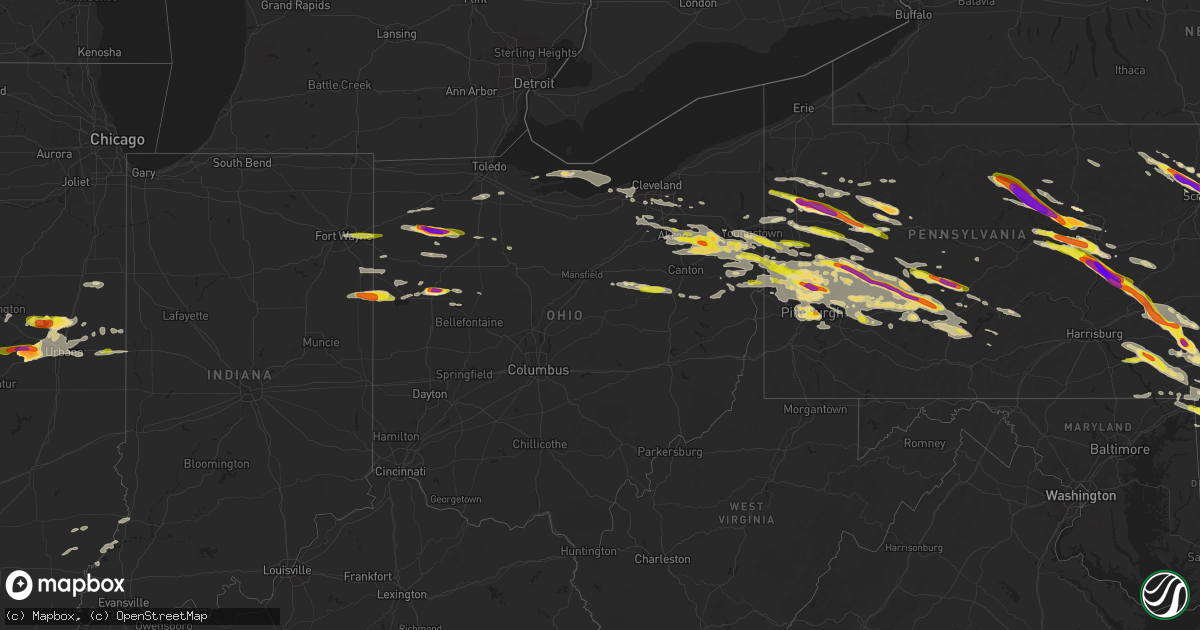
Hail Map in Ohio on May 28, 2019
Get this storm
May 28 map
$229
one time, instant access
Download today. No call, no setup
Keep the $229
Bought the map and want the full workflow? Apply the entire $229 to a subscription within 7 days. None of it is wasted.
Every map, not just this one
This buys you this map. Subscription and you get every map we run, in the markets you choose from a few cities to whole states to nationwide. Plus real-time alerts the moment a storm fires.
Contact data
Name, contact info, occupancy, even credit band for addresses in the footprint. You go from where it hit to who to call.
Become the source they trust
Unlimited branding weather history reports on demand. You already have the documented answer ready for the property owner, and you are the one who showed up with it.
Property data and RoofTrace estimates
Pull up any address you have got, its value and the exact code rules for that jurisdiction, straight from One Click Code. Then RoofTrace estimates the squares, pitch, and roof value, priced the way you price.
Storm reports in Ohio
Ohio
| Date | Description |
|---|---|
| 05/28/20196:50 PM CDT | Large... Healthy tree limbs and power poles down. |
| 05/28/20196:09 PM CDT | A local report indicates 73 MPH wind near 2 ESE AVON |
| 05/28/20196:07 PM CDT | A local report indicates 72 MPH wind near 1 N AVON |
| 05/28/20195:50 PM CDT | A local report indicates 60 MPH wind near 1 N AVON |
| 05/28/20195:48 PM CDT | Tree limbs down on car. |
| 05/28/20195:23 PM CDT | A local report indicates 1.00 inch wind near 1 E CANFIELD |
| 05/28/20195:20 PM CDT | A local report indicates 1.00 inch wind near 1 ENE CANFIELD |
| 05/28/20195:10 PM CDT | A local report indicates 1.25 inch wind near 6 SE CRAIG BEACH |
| 05/28/20195:07 PM CDT | A local report indicates 1.00 inch wind near CELINA |
| 05/28/20195:04 PM CDT | A local report indicates 1.00 inch wind near MINERAL CITY |
| 05/28/20195:00 PM CDT | A local report indicates 1.00 inch wind near 3 SW SILVER LAKE |
| 05/28/20195:00 PM CDT | A local report indicates 1.00 inch wind near 2 SSE CUYAHOGA FALLS |
| 05/28/20194:53 PM CDT | A local report indicates 1.50 inch wind near SSW CHATTANOOGA |
| 05/28/20194:50 PM CDT | Large tree down on tr 654 north of cr 160. |
| 05/28/20194:48 PM CDT | A local report indicates 1.00 inch wind near WAYNESVILLE |
| 05/28/20194:44 PM CDT | Corrects previous tstm wnd dmg report from 5 sw wilmot. Multiple trees down on sr 515. |
| 05/28/20194:43 PM CDT | A local report indicates 2.00 inch wind near 1 N UNIOPOLIS |
| 05/28/20194:22 PM CDT | Pea to quarter sized hail. |
| 05/28/20194:05 PM CDT | Reported at mccomb ohio. |
| 05/28/20193:47 PM CDT | Hail sizes range from 1 inch to 3 inches in town. |
| 05/28/20193:44 PM CDT | A local report indicates 1.50 inch wind near 4 NNW LIMAVILLE |
| 05/28/20193:34 PM CDT | A local report indicates 1.00 inch wind near 2 WNW WISTERMAN |
| 05/28/20193:33 PM CDT | 1.5 to 2 inches. Picture on social media. |
| 05/28/20193:32 PM CDT | A local report indicates 1.00 inch wind near PAYNE |
| 05/28/20193:15 PM CDT | Reported at 3900 mogadore industrial parkway. |
| 05/28/20193:14 PM CDT | A local report indicates 1.00 inch wind near 1 N LAKEMORE |
| 05/28/20192:51 PM CDT | Tree down blocking road. |
| 05/28/20192:03 PM CDT | A local report indicates 1.00 inch wind near 1 NE CANNONS MILL |
| 05/28/20197:50 AM CDT | At 1249 AM EDT, a severe thunderstorm was located over Perry State Forest, moving northeast at 30 mph. HAZARD...Wind gusts to 60 mph and half dollar-size hail. SOURCE...Radar. IMPACT...Minor hail damage to vehicles is possible. Expect wind damage to trees and power lines, resulting in some power outages. Locations impacted include... Zanesville... New Concord... South Zanesville... North Zanesville... Philo... Pleasant Grove... Fultonham... Norwich... Cannelville... Chandlersville... Bridgeville... Duncan Falls...This includes Interstate 70 in Ohio between mile markers 147 and170. |
| 05/28/20197:45 AM CDT | At 1245 AM EDT, a severe thunderstorm was located near Circleville, moving southeast at 40 mph. HAZARD...60 mph wind gusts and quarter size hail. SOURCE...Radar indicated. IMPACT...Minor hail damage to vehicles is possible. Expect wind damage to trees and power lines. Locations impacted include... Circleville, Logan, Ashville, South Bloomfield, Kingston, Williamsport, Hocking Hills State Park, Logan Elm Village, Fox, Amanda, Stoutsville, Laurelville, Clarksburg, Sugar Grove, Adelphi, Tarlton, East Ringgold, Ilesboro, South Bloomingville and Clearport. |
| 05/28/20197:22 AM CDT | At 1222 AM EDT, a severe thunderstorm was located near McConnelsville, moving east at 30 mph. HAZARD...Wind gusts to 60 mph and quarter-size hail. SOURCE...Radar. IMPACT...Minor hail damage to vehicles is possible. Expect wind damage to trees and power lines, resulting in some power outages. Locations impacted include... Caldwell... Dudley... Summerfield... Belle Valley... Sarahsville... Dexter City... Ruraldale... High Hill... Harriettsville... Seneca Lake Park... Wolf Run State Park... Blue Rock State Park...This includes Interstate 77 in Ohio between mile markers 18 and 36. |
| 05/28/20192:53 AM CDT | At 753 PM EDT, a severe thunderstorm was located over New Waterford, or over Columbiana, moving east at 55 mph. HAZARD...Wind gusts to 60 mph and quarter-size hail. SOURCE...Radar. IMPACT...Minor hail damage to vehicles is possible. Expect wind damage to trees and power lines, resulting in some power outages. Locations impacted include... Cranberry... Beaver Falls... Columbiana... East Palestine... Ellwood City... New Brighton... Zelienople... Rochester... Seven Fields... Leetonia... Evans City... New Waterford...This includes the following highways... Pennsylvania Turnpike between mile markers 2 and 29. Interstate 79 in Pennsylvania between mile markers 79 and 97. Interstate 376 in Pennsylvania between mile markers 31 and 34. |
| 05/28/20191:57 AM CDT | At 657 PM EDT, a severe thunderstorm was located over Avon Lake, or 7 miles northeast of Elyria, moving east at 50 mph. HAZARD...60 mph wind gusts and quarter size hail. SOURCE...Radar indicated. IMPACT...Minor damage to vehicles is possible. Expect damage to trees and power lines. Locations impacted include... Cleveland, Lorain, Elyria, Parma, Lakewood, Euclid, Cleveland Heights, Strongsville, Brunswick, Westlake, North Royalton, North Ridgeville, Solon, Avon Lake, Warrensville Heights, Highland Hills, North Olmsted, Garfield Heights, Shaker Heights and Maple Heights. |
| 05/28/20191:23 AM CDT | At 623 PM EDT, a severe thunderstorm was located near Ravenna, moving east at 40 mph. HAZARD...60 mph wind gusts and quarter size hail. SOURCE...Radar indicated. IMPACT...Minor damage to vehicles is possible. Expect damage to trees and power lines. Locations impacted include... Ravenna, Kent, Brimfield, Randolph, Atwater, Edinburg, Deerfield and Brady Lake. |
| 05/28/20191:16 AM CDT | At 616 PM EDT, a severe thunderstorm was located 8 miles northeast of Sebring, or 10 miles northwest of Salem, moving east at 55 mph. HAZARD...60 mph wind gusts and quarter size hail. SOURCE...Radar indicated. IMPACT...Minor damage to vehicles is possible. Expect damage to trees and power lines. Locations impacted include... Youngstown, Salem, Columbiana, Boardman, Campbell, Canfield, Austintown, Struthers, Poland, Ellsworth, New Middletown, Craig Beach, Lowellville, Deerfield, North Jackson, Berlin Center, Greenford and Mineral Ridge. |
| 05/28/201912:49 AM CDT | At 549 PM EDT, a severe thunderstorm was located near Rockford, or 9 miles northwest of Celina, moving east at 45 mph. HAZARD...60 mph wind gusts and half dollar size hail. SOURCE...Radar indicated. IMPACT...Hail damage to vehicles is expected. Expect wind damage to roofs, siding, and trees. Locations impacted include... Trinity and New Corydon. |
| 05/28/201912:40 AM CDT | At 539 PM EDT, a severe thunderstorm was located 8 miles southwest of Rockford, moving east at 30 mph. HAZARD...60 mph wind gusts and quarter size hail. SOURCE...Radar indicated. IMPACT...Minor hail damage to vehicles is possible. Expect wind damage to trees and power lines. Locations impacted include... Celina, St. Marys, Rockford, New Knoxville, Moulton, Wabash, Mendon, Buckland, Chattanooga, Kossuth, Tama, Neptune, State Route 116 at State Route 197 and Bulkhead. |
| 05/28/201912:39 AM CDT | At 539 PM EDT, a severe thunderstorm was located over Winesburg, or 12 miles northwest of Dover, moving east at 35 mph. HAZARD...Wind gusts to 60 mph and quarter-size hail. SOURCE...Radar. IMPACT...Minor hail damage to vehicles is possible. Expect wind damage to trees and power lines, resulting in some power outages. Locations impacted include... New Philadelphia... Dover... Carrollton... Strasburg... Bolivar... Mineral City... Bowerston... Dellroy... Sherrodsville... Roswell... Parral... Zoar...This includes Interstate 77 in Ohio between mile markers 82 and 94. |
| 05/28/201912:39 AM CDT | At 538 PM EDT, a severe thunderstorm was located over Cridersville, or near Fort Shawnee, moving east at 30 mph. HAZARD...60 mph wind gusts and quarter size hail. SOURCE...Trained weather spotters reported half inch sized hail near Cridersville at 535 PM EDT. IMPACT...Hail damage to vehicles is expected. Expect wind damage to roofs, siding, and trees. Locations impacted include... Lima, Fort Shawnee, Harrod, Yoder, Westminster, Hume and Rousculp. This includes Interstate 75 between mile markers 119 and 123. |
| 05/28/201912:36 AM CDT | At 536 PM EDT, a severe thunderstorm was located near Cridersville, moving east at 30 mph. HAZARD...60 mph wind gusts and quarter size hail. SOURCE...Radar indicated. IMPACT...Minor hail damage to vehicles is possible. Expect wind damage to trees and power lines. Locations impacted include... Wapakoneta, Kenton, Fort Shawnee, Cridersville, Alger, Waynesfield, Roundhead, Mcguffey, Uniopolis, Fryburg, Silver Creek, Jumbo, St. Johns, Walton, New Hampshire and State Route 195 at State Route 235.This includes I-75 in Ohio between mile markers 108 and 118. |
| 05/28/201912:35 AM CDT | At 534 PM EDT, a severe thunderstorm was located over Geneva, or near Berne, moving east at 45 mph. HAZARD...60 mph wind gusts and half dollar size hail. SOURCE...Radar indicated. IMPACT...Hail damage to vehicles is expected. Expect wind damage to roofs, siding, and trees. Locations impacted include... Berne, Geneva, Bryant, Trinity, Linn Grove, New Corydon and Ceylon. |
| 05/28/201912:16 AM CDT | At 516 PM EDT, a severe thunderstorm was located over Holmesville, or 7 miles north of Millersburg, moving east at 45 mph. HAZARD...60 mph wind gusts and quarter size hail. SOURCE...Radar indicated. IMPACT...Minor damage to vehicles is possible. Expect damage to trees and power lines. Locations impacted include... Wooster, Brewster, Navarre, Shreve, Waynesburg, East Sparta, Holmesville, Wilmot, Mount Eaton, Winesburg, Apple Creek, Beach City, Fredericksburg and Mount Hope. |
| 05/28/201912:13 AM CDT | At 513 PM EDT, a severe thunderstorm was located over Hartville, or 10 miles northeast of Canton, moving east at 35 mph. HAZARD...60 mph wind gusts and quarter size hail. SOURCE...Radar indicated. IMPACT...Minor damage to vehicles is possible. Expect damage to trees and power lines. Locations impacted include... Salem, Columbiana, Boardman, Alliance, Canfield, Sebring, Hartville, Struthers, Atwater, Poland, Ellsworth, New Middletown, Lowellville, Beloit, Deerfield, Limaville, Berlin Center, Maple Ridge, Maximo and Greenford. |
| 05/28/201912:12 AM CDT | At 512 PM EDT, a severe thunderstorm was located over Columbiana, moving east at 40 mph. HAZARD...Ping-pong ball-size hail and wind gusts to 60 mph. SOURCE...Radar. IMPACT...People and animals outdoors will be injured. Expect hail damage to roofs, siding, windows, and vehicles. Expect wind damage to trees and power lines, resulting in some power outages. Locations impacted include... New Castle... Aliquippa... Beaver Falls... Columbiana... Monaca... East Palestine... Economy... Ellwood City... New Brighton... Beaver... Baden... Rochester...This includes the following highways... Pennsylvania Turnpike between mile markers 1 and 22. Interstate 79 in Pennsylvania between mile markers 96 and 99. Interstate 376 in Pennsylvania between mile markers 31 and 41. |
| 05/27/201911:48 PM CDT | At 448 PM EDT, a severe thunderstorm was located over Leipsic, or near Ottawa, moving east at 35 mph. HAZARD...Ping pong ball size hail and 60 mph wind gusts. SOURCE...Radar indicated. IMPACT...People and animals outdoors will be injured. Expect hail damage to roofs, siding, windows, and vehicles. Expect damage to trees and power lines. Locations impacted include... Findlay, Fostoria, North Baltimore, McComb, Arcadia, Vanlue, Van Buren, Bloomdale, Benton Ridge and Bairdstown. |
| 05/27/201911:37 PM CDT | At 437 PM EDT, a severe thunderstorm was located near Alliance, or 12 miles southeast of Ravenna, moving east at 40 mph. HAZARD...Ping pong ball size hail and 60 mph wind gusts. SOURCE...Radar indicated. IMPACT...People and animals outdoors will be injured. Expect hail damage to roofs, siding, windows, and vehicles. Expect damage to trees and power lines. Locations impacted include... Youngstown, Salem, Columbiana, Boardman, Alliance, Canfield, Sebring, Austintown, Struthers, Poland, Ellsworth, New Middletown, Lowellville, Beloit, Deerfield, Berlin Center, Maple Ridge and Greenford. |
| 05/27/201911:32 PM CDT | At 432 PM EDT, a severe thunderstorm was located near Campbell, or 7 miles east of Youngstown, moving east at 40 mph. HAZARD...Wind gusts to 60 mph and quarter-size hail. SOURCE...Radar. IMPACT...Minor hail damage to vehicles is possible. Expect wind damage to trees and power lines, resulting in some power outages. Locations impacted include... New Castle... Butler... Homeacre-Lyndora... Shanor-Northvue... Meridian... Slippery Rock... Meadowood... New Wilmington... Oak Hills... Oakwood... New Castle Northwest... Pulaski...This includes the following highways... Interstate 79 in Pennsylvania between mile markers 94 and 112. Interstate 376 in Pennsylvania between mile markers 4 and 14. |
| 05/27/201911:24 PM CDT | At 423 PM EDT, a severe thunderstorm was located near Continental, or 9 miles south of Defiance, moving east at 35 mph. HAZARD...Golf ball size hail. SOURCE...Radar indicated. IMPACT...People and animals outdoors will be injured. Expect damage to roofs, siding, windows, and vehicles. This severe thunderstorm will be near... Leipsic and Deshler around 455 PM EDT.Other locations impacted by this severe thunderstorm include NorthCreek, West Leipsic, Prentiss, Hamler, Kieferville, Gallup, MillerCity, Belmore, Pleasant Bend and Wisterman. |
| 05/27/201911:04 PM CDT | At 404 PM EDT, a severe thunderstorm was located over Tallmadge, or near Akron, moving east at 45 mph. HAZARD...Ping pong ball size hail and 60 mph wind gusts. SOURCE...Radar indicated. IMPACT...People and animals outdoors will be injured. Expect hail damage to roofs, siding, windows, and vehicles. Expect damage to trees and power lines. Locations impacted include... Akron, Ravenna, Cuyahoga Falls, Kent, Barberton, Green, Alliance, Tallmadge, Mogadore, Hartville, Stow, Norton, Brimfield, Randolph, Munroe Falls, Lakemore, Atwater, Edinburg, Silver Lake and Deerfield. |
| 05/27/201910:56 PM CDT | At 355 PM EDT, a severe thunderstorm was located over Newton Falls, or 9 miles southwest of Warren, moving east at 40 mph. HAZARD...60 mph wind gusts and quarter size hail. SOURCE...Radar indicated. IMPACT...Minor damage to vehicles is possible. Expect damage to trees and power lines. Locations impacted include... Youngstown, Warren, Boardman, Niles, Campbell, Hubbard, Canfield, Newton Falls, Lordstown, Hilltop, Maplewood Park, Austintown, Struthers, Girard, McDonald, Poland, Ellsworth, New Middletown, Craig Beach and Lowellville. |
| 05/27/201910:34 PM CDT | At 334 PM EDT, a severe thunderstorm was located near Ravenna, moving east at 35 mph. HAZARD...60 mph wind gusts and quarter size hail. SOURCE...Radar indicated. IMPACT...Minor damage to vehicles is possible. Expect damage to trees and power lines. Locations impacted include... Ravenna, Kent, Tallmadge, Streetsboro, Brimfield, Edinburg, Windham, Brady Lake, Sugar Bush Knolls and Wayland. |
| 05/27/20199:50 PM CDT | At 249 PM EDT, a severe thunderstorm was located over Twinsburg, or 16 miles northwest of Ravenna, moving east at 25 mph. HAZARD...60 mph wind gusts and quarter size hail. SOURCE...Radar indicated. IMPACT...Minor damage to vehicles is possible. Expect damage to trees and power lines. Locations impacted include... Solon, Hudson, Twinsburg, Streetsboro, Macedonia, Garrettsville, Mantua, Aurora, Bedford, Bedford Heights, Parkman, Northfield, Reminderville, Walton Hills, Windham, Hiram, Glenwillow and Bainbridge. |
| 05/27/20198:45 PM CDT | At 145 AM EDT, a severe thunderstorm was located near McConnelsville, moving southeast at 40 mph. HAZARD...65 mph wind gusts and quarter size hail. SOURCE...Radar indicated. IMPACT...Hail damage to vehicles is expected. Expect considerable tree damage. Wind damage is also likely to mobile homes, roofs, and outbuildings. Locations impacted include... McConnelsville, Beverly, Chesterhill, Crooksville, Malta, Stockport, Bristol, Eagleport and Hackney. |
| 05/27/20198:27 PM CDT | At 126 AM EDT, a severe thunderstorm was located near Logan Elm Village, moving east at 30 mph. HAZARD...60 mph wind gusts and quarter size hail. SOURCE...Radar indicated. IMPACT...Minor hail damage to vehicles is possible. Expect wind damage to trees and power lines. Locations impacted include... Circleville, Kingston, Logan Elm Village, Laurelville, Clarksburg, Adelphi, Tarlton, Pickaway County Airport, State Route 138 at US Route 22, Hallsville and Whisler. |
| 05/27/20198:24 PM CDT | At 124 AM EDT, a severe thunderstorm was located near Perry State Forest, moving east at 35 mph. HAZARD...Wind gusts to 60 mph and quarter-size hail. SOURCE...Radar. IMPACT...Minor hail damage to vehicles is possible. Expect wind damage to trees and power lines, resulting in some power outages. Locations impacted include... Zanesville... South Zanesville... Philo... Pleasant Grove... Gratiot... Fultonham... Cannelville... High Hill... Chandlersville... Ruraldale... Duncan Falls... East Fultonham...This includes Interstate 70 in Ohio between mile markers 143 and151, and near mile marker 155. |
| 05/27/20198:11 PM CDT | At 110 AM EDT, a severe thunderstorm was located near Somerset, moving southeast at 35 mph. HAZARD...65 mph wind gusts and quarter size hail. SOURCE...Radar indicated. IMPACT...Hail damage to vehicles is expected. Expect wind damage to roofs, siding, and trees. Locations impacted include... New Lexington, Somerset, Shawnee, Perry State Forest, Crooksville, Thornville, Junction City, Glenford and Hemlock. |
| 05/27/20197:15 PM CDT | Trees down along rt 517 to the ne of lisbon |
| 05/27/20197:11 PM CDT | Trees down along rt 558 |
All States Impacted by Hail Map on May 28, 2019
Cities Impacted by Hail Map on May 28, 2019
- Big Spring, TX
- Lancaster, PA
- Linden, PA
- Jersey Shore, PA
- Williamsport, PA
- Dalton, PA
- Enon Valley, PA
- Garwood, NJ
- Staten Island, NY
- Roselle, NJ
- Clark, NJ
- Linden, NJ
- Westfield, NJ
- Rahway, NJ
- Cranford, NJ
- Carteret, NJ
- Mountainside, NJ
- Hutchinson, KS
- Abbyville, KS
- Partridge, KS
- Nickerson, KS
- Columbus, KS
- Chetopa, KS
- Miami, OK
- Welch, OK
- Manchester Township, NJ
- Atlanta, MO
- Peru, NE
- Julian, NE
- Nebraska City, NE
- Brock, NE
- Fremont, MO
- Alton, MO
- Doniphan, MO
- Iowa Park, TX
- Randlett, OK
- Duncan, OK
- Foster, OK
- Konawa, OK
- Sasakwa, OK
- Tussy, OK
- Temple, OK
- Allen, OK
- Comanche, OK
- Devol, OK
- Burkburnett, TX
- Grandfield, OK
- Walters, OK
- Wynnewood, OK
- Pauls Valley, OK
- Ada, OK
- Hennepin, OK
- Elmore City, OK
- Holdenville, OK
- Davis, OK
- Marlow, OK
- Stratford, OK
- Tingley, IA
- Diagonal, IA
- Mount Ayr, IA
- Bairdford, PA
- Saxonburg, PA
- Tarentum, PA
- Mars, PA
- Cranberry Township, PA
- Warrendale, PA
- Glenshaw, PA
- Beaver Falls, PA
- Evans City, PA
- Gibsonia, PA
- Sewickley, PA
- Bakerstown, PA
- Baden, PA
- Zelienople, PA
- Russellton, PA
- Renfrew, PA
- Rochester, PA
- Cheswick, PA
- Callery, PA
- Freedom, PA
- Wexford, PA
- New Brighton, PA
- Allison Park, PA
- Valencia, PA
- Butler, PA
- Pittsburgh, PA
- East Freedom, PA
- New Enterprise, PA
- Claysburg, PA
- Portage, PA
- Duncansville, PA
- Roaring Spring, PA
- Sproul, PA
- Imler, PA
- Martinsburg, PA
- White Heath, IL
- Mansfield, IL
- Cisco, IL
- Weldon, IL
- Mahomet, IL
- Seymour, IL
- De Land, IL
- Monticello, IL
- Clubb, MO
- Silva, MO
- Greenville, MO
- Reinholds, PA
- Womelsdorf, PA
- Elverson, PA
- Wernersville, PA
- Richland, PA
- Mohnton, PA
- Morgantown, PA
- Narvon, PA
- Glenmoore, PA
- Robesonia, PA
- Birdsboro, PA
- Bernville, PA
- Reading, PA
- Ellis, KS
- Wakeeney, KS
- Ogallah, KS
- Collyer, KS
- Rush Springs, OK
- Roscoe, TX
- Sweetwater, TX
- Loraine, TX
- Scandia, KS
- Belleville, KS
- Wapakoneta, OH
- Huntsville, OH
- Belle Center, OH
- Lakeview, OH
- Jackson, MO
- Wellsville, OH
- East Liverpool, OH
- Van Wert, IA
- Grand River, IA
- Exton, PA
- Downingtown, PA
- Benton, KS
- Burns, KS
- Whitewater, KS
- Potwin, KS
- Mehoopany, PA
- Tunkhannock, PA
- Olyphant, PA
- Factoryville, PA
- Scranton, PA
- Clarks Summit, PA
- Laceyville, PA
- Moscow, PA
- Lake Ariel, PA
- Falls, PA
- Meshoppen, PA
- Belvue, KS
- Chatsworth, NJ
- North East, MD
- Charlestown, MD
- Perryville, MD
- Elkton, MD
- Manhattan, KS
- Rotan, TX
- New Galilee, PA
- Du Bois, NE
- Hiawatha, KS
- Blue Rapids, KS
- Goff, KS
- Craig, MO
- Guilford, MO
- Sabetha, KS
- Vermillion, KS
- Axtell, KS
- Amazonia, MO
- Soldier, KS
- Morrill, KS
- Olsburg, KS
- Holton, KS
- Forest City, MO
- Robinson, KS
- Fairview, KS
- Savannah, MO
- Netawaka, KS
- Rulo, NE
- Fillmore, MO
- Oneida, KS
- White Cloud, KS
- Barnard, MO
- Baileyville, KS
- Maitland, MO
- Oregon, MO
- Frankfort, KS
- Horton, KS
- Westmoreland, KS
- Falls City, NE
- Humboldt, NE
- Emmett, KS
- Bolckow, MO
- Bern, KS
- Mound City, MO
- Highland, KS
- Rosendale, MO
- Wetmore, KS
- Delia, KS
- Whiting, KS
- Centralia, KS
- Circleville, KS
- Seneca, KS
- Everest, KS
- Corning, KS
- Dawson, NE
- Latrobe, PA
- Leetsdale, PA
- Cabot, PA
- Hinckley, OH
- New Florence, PA
- Berlin Center, OH
- Greensburg, PA
- Sarver, PA
- Ebensburg, PA
- Cowansville, PA
- Monaca, PA
- Kent, OH
- Akron, OH
- Indiana, PA
- Gallitzin, PA
- Darlington, PA
- McIntyre, PA
- Creighton, PA
- Diamond, OH
- Homer City, PA
- Brush Valley, PA
- Wampum, PA
- Beloit, OH
- Woodbury, PA
- Blairsville, PA
- Spring Church, PA
- Johnstown, PA
- McGrann, PA
- Nanty Glo, PA
- Rootstown, OH
- North Benton, OH
- Hartville, OH
- South Heights, PA
- Yatesboro, PA
- Shelocta, PA
- Delmont, PA
- Portersville, PA
- Ashville, PA
- Barberton, OH
- North Apollo, PA
- Vintondale, PA
- Louisville, OH
- Aultman, PA
- Ravenna, OH
- Oakmont, PA
- Crescent, PA
- Canfield, OH
- Salineville, OH
- Saxton, PA
- McKees Rocks, PA
- Marion Center, PA
- Washingtonville, OH
- Sebring, OH
- Chicora, PA
- North Jackson, OH
- Youngstown, OH
- Medina, OH
- New Springfield, OH
- Apollo, PA
- Ford Cliff, PA
- Sidman, PA
- Clinton, PA
- Avonmore, PA
- Munroe Falls, OH
- Freeport, PA
- Rogers, OH
- Export, PA
- Uniontown, OH
- Fenelton, PA
- James Creek, PA
- Negley, OH
- Bridgeville, PA
- West Lebanon, PA
- Coraopolis, PA
- Beaver, PA
- Lakemore, OH
- Harmony, PA
- Deerfield, OH
- West Mifflin, PA
- Newry, PA
- Indianola, PA
- Coral, PA
- Josephine, PA
- Saltsburg, PA
- Ellwood City, PA
- Fombell, PA
- Leetonia, OH
- Rural Valley, PA
- Midland, PA
- Starford, PA
- Lisbon, OH
- Cuyahoga Falls, OH
- New Waterford, OH
- Springdale, PA
- Pulaski, PA
- Carnegie, PA
- Edinburg, PA
- Limaville, OH
- Natrona Heights, PA
- Vandergrift, PA
- Slippery Rock, PA
- Commodore, PA
- New Kensington, PA
- Bradfordwoods, PA
- Heilwood, PA
- East Palestine, OH
- Hanoverton, OH
- Slickville, PA
- Williamsburg, PA
- Damascus, OH
- Brackenridge, PA
- Home, PA
- Connoquenessing, PA
- Tallmadge, OH
- Ambridge, PA
- Black Lick, PA
- Clymer, PA
- Lyndora, PA
- Koppel, PA
- Mineral Point, PA
- East Butler, PA
- Presto, PA
- New Alexandria, PA
- Conway, PA
- Twin Rocks, PA
- Petersburg, OH
- New Derry, PA
- Summerhill, PA
- Harwick, PA
- Industry, PA
- North Canton, OH
- New Castle, PA
- Penn Run, PA
- Seward, PA
- East Rochester, OH
- Ford City, PA
- Northern Cambria, PA
- Braddock, PA
- Hillsville, PA
- Campbell, OH
- Carrolltown, PA
- Clarksburg, PA
- Leechburg, PA
- North Lima, OH
- Lake Milton, OH
- Columbiana, OH
- Loretto, PA
- Derry, PA
- Salem, OH
- Bessemer, PA
- Elderton, PA
- Manorville, PA
- Clune, PA
- Mogadore, OH
- Homestead, PA
- Worthington, PA
- Brunswick, OH
- Prospect, PA
- Colver, PA
- Canton, OH
- Belsano, PA
- Aliquippa, PA
- Oakdale, PA
- Hollidaysburg, PA
- Cresson, PA
- Dilltown, PA
- Alliance, OH
- Struthers, OH
- Lucernemines, PA
- Kittanning, PA
- Valley City, OH
- Ernest, PA
- Atwater, OH
- Creekside, PA
- Crabtree, PA
- Dixonville, PA
- Verona, PA
- Murrysville, PA
- South Fork, PA
- Lilly, PA
- Lowellville, OH
- Nicktown, PA
- Sagamore, PA
- Adrian, PA
- Mentcle, PA
- Armagh, PA
- Strongstown, PA
- Pawnee City, NE
- Yukon, OK
- Edmond, OK
- Cashion, OK
- El Reno, OK
- Okarche, OK
- Piedmont, OK
- Berwick, IL
- Kirkwood, IL
- Roseville, IL
- Cameron, IL
- Smithshire, IL
- Stronghurst, IL
- Raritan, IL
- Biggsville, IL
- Media, IL
- Monmouth, IL
- Clarion, PA
- Sligo, PA
- Perkins, OK
- Stillwater, OK
- Toms River, NJ
- Alexandria, PA
- Altoona, PA
- Tyrone, PA
- Atoka, OK
- Coleman, OK
- Kenefic, OK
- Green City, MO
- Unionville, MO
- Murray, IA
- Steele City, NE
- Mahaska, KS
- Esbon, KS
- Randall, KS
- Waldo, KS
- Paradise, KS
- Formoso, KS
- Plainville, KS
- Marysville, KS
- Luray, KS
- Beloit, KS
- Morrowville, KS
- Odell, NE
- Courtland, KS
- Fairbury, NE
- Bremen, KS
- Haddam, KS
- Jewell, KS
- Beatrice, NE
- Natoma, KS
- Cawker City, KS
- Glen Elder, KS
- Diller, NE
- Linn, KS
- Clifton, KS
- Osborne, KS
- Alton, KS
- Cuba, KS
- Endicott, NE
- Blue Springs, NE
- Mankato, KS
- Narka, KS
- Norway, KS
- Tipton, KS
- Washington, KS
- Munden, KS
- Downs, KS
- Hanover, KS
- Hollenberg, KS
- Wymore, NE
- Geneva, IN
- Stanton, TX
- Fisher, IL
- Gibson City, IL
- Dewey, IL
- Thomasboro, IL
- Ludlow, IL
- Champaign, IL
- Paxton, IL
- Rantoul, IL
- Valley Center, KS
- Sandy Lake, PA
- Lickingville, PA
- Cooksburg, PA
- Clarington, PA
- Tionesta, PA
- Fryburg, PA
- Vowinckel, PA
- Lucinda, PA
- Sigel, PA
- Venus, PA
- Leeper, PA
- Strattanville, PA
- Brookville, PA
- Ringtown, PA
- Shenandoah, PA
- Catawissa, PA
- Elysburg, PA
- Wilburton, PA
- Brashear, MO
- Hurdland, MO
- Baring, MO
- Mifflinburg, PA
- Stoneboro, PA
- Polk, PA
- Fredonia, PA
- Clarks Mills, PA
- Cheyenne Wells, CO
- Pinckneyville, IL
- Lomax, IL
- Scott City, KS
- Saint Georges, DE
- New Castle, DE
- Delaware City, DE
- Salem, NJ
- Middletown, DE
- Bear, DE
- Newark, DE
- Hope, KS
- Arapahoe, CO
- Newton, KS
- Mill Creek, PA
- Huntingdon, PA
- Orbisonia, PA
- McVeytown, PA
- Oakley, KS
- Tonganoxie, KS
- Linwood, KS
- Lawrence, KS
- Pleasantville, PA
- Kokomo, IN
- Manahawkin, NJ
- Barnegat, NJ
- Waynesfield, OH
- Lima, OH
- Uniopolis, OH
- Coyle, OK
- Bloomfield, IA
- Bendena, KS
- Troy, KS
- Overbrook, KS
- Carbondale, KS
- Scranton, KS
- Berryton, KS
- Alma, KS
- Topeka, KS
- Sugar Run, PA
- Wyalusing, PA
- New Albany, PA
- Nottingham, PA
- Peach Bottom, PA
- New London, MO
- Center, MO
- Mcalester, OK
- Indiahoma, OK
- Wallace, KS
- Cottonwood Falls, KS
- Braddyville, IA
- North Bend, PA
- Lock Haven, PA
- Lawton, OK
- Flinton, PA
- Fallentimber, PA
- La Harpe, IL
- Albia, IA
- Dallas City, IL
- Osceola, IA
- Keosauqua, IA
- Continental, OH
- Miller City, OH
- Ottawa, OH
- Leipsic, OH
- Calverton, NY
- Purcell, OK
- Montandon, PA
- Lewisburg, PA
- Milton, PA
- Elizabeth, NJ
- Newark, NJ
- Quinter, KS
- Maple Hill, KS
- Russell, IA
- Chariton, IA
- Pulaski, IA
- Guthrie, OK
- Osage City, KS
- Lyndon, KS
- Midland, TX
- Parker, PA
- Harrisville, PA
- Boyers, PA
- Petrolia, PA
- Hilliards, PA
- West Burlington, IA
- Burlington, IA
- Sperry, IA
- Pennsville, NJ
- Templeton, PA
- Westover, PA
- Coalport, PA
- Hastings, PA
- Glen Campbell, PA
- Patton, PA
- La Jose, PA
- Cherry Tree, PA
- Concordia, KS
- Jamestown, KS
- Sharon Springs, KS
- Penns Grove, NJ
- Wilmington, DE
- Alloway, NJ
- Shiloh, NJ
- Woodstown, NJ
- Bridgeton, NJ
- Speer, IL
- Gracemont, OK
- Brookfield, MO
- Blythedale, MO
- Ridgeway, MO
- Cainsville, MO
- Richmond, MO
- Rayville, MO
- Polo, MO
- Cowgill, MO
- Whitefield, OK
- Stigler, OK
- Oakwood, OH
- Mercer, PA
- Grove City, PA
- Bruin, PA
- West Sunbury, PA
- Remsenburg, NY
- Speonk, NY
- Paris, MO
- Shelbina, MO
- Memphis, MO
- Arbela, MO
- Morris Plains, NJ
- Hammonton, NJ
- Cantril, IA
- Leonard, MO
- Shelbyville, MO
- Bethel, MO
- Weldon, IA
- Cutler, IN
- Bringhurst, IN
- Rossville, IN
- Browning, IL
- Havana, IL
- Astoria, IL
- Burr Oak, KS
- Red Cloud, NE
- Lebanon, KS
- Strasburg, PA
- Manheim, PA
- Gordonville, PA
- Smoketown, PA
- Ronks, PA
- Bird In Hand, PA
- Paradise, PA
- East Petersburg, PA
- Lititz, PA
- Fletcher, OK
- East Stroudsburg, PA
- Blairstown, NJ
- Columbia, NJ
- Catlin, IL
- Tilton, IL
- Oakwood, IL
- Fithian, IL
- Covington, IN
- Fairmount, IL
- Danville, IL
- Harrod, OH
- Havensville, KS
- Dwight, KS
- Alta Vista, KS
- Wamego, KS
- Junction City, KS
- Saint Marys, KS
- Clearfield, IA
- Argenta, IL
- Novelty, MO
- La Plata, MO
- Eufaula, OK
- Berne, IN
- Rockford, OH
- Bryant, IN
- Celina, OH
- Keystone, IN
- Coldwater, OH
- Tecumseh, NE
- Cook, NE
- Steinauer, NE
- Elk Creek, NE
- Imboden, AR
- Sheppard Afb, TX
- Wichita Falls, TX
- Rockton, PA
- Cassville, PA
- Mapleton Depot, PA
- Cache, OK
- Fort Sill, OK
- Honey Brook, PA
- Hinton, OK
- Darlington, MO
- Albany, MO
- McFall, MO
- Gilman City, MO
- Rea, MO
- Stanberry, MO
- Princeton, MO
- King City, MO
- Eagleville, MO
- Union Star, MO
- Bethany, MO
- New Hampton, MO
- Kermit, TX
- Cross Fork, PA
- Monroe, CT
- Ansonia, CT
- Orange, CT
- Woodbridge, CT
- Shelton, CT
- New Haven, CT
- Derby, CT
- Newtown, CT
- West Haven, CT
- Keansburg, NJ
- Calvin, OK
- Clay Center, KS
- Knox, PA
- Shamokin, PA
- Klingerstown, PA
- Leck Kill, PA
- Dornsife, PA
- Selinsgrove, PA
- Paxinos, PA
- Middleburg, PA
- Winfield, PA
- Sunbury, PA
- Trevorton, PA
- Shamokin Dam, PA
- Rebuck, PA
- Goldsmith, TX
- Ripley, OK
- Monticello, MO
- Lewistown, MO
- Weskan, KS
- Stevensville, PA
- Monroeville, IN
- Woodburn, IN
- New Haven, IN
- Fort Wayne, IN
- Coahoma, TX
- Glencoe, OK
- Yale, OK
- Roby, TX
- Sylvester, TX
- Arriba, CO
- Emporia, KS
- Mccurtain, OK
- Bokoshe, OK
- Sheffield, PA
- Knoxville, IL
- Gilson, IL
- Glen Mills, PA
- Garnet Valley, PA
- Chadds Ford, PA
- Hermitage, PA
- Westboro, MO
- Tarkio, MO
- Gravity, IA
- New Market, IA
- Bedford, IA
- Blanchard, IA
- Shannon City, IA
- Shubert, NE
- Clarinda, IA
- Nemaha, NE
- Hopkins, MO
- Sharpsburg, IA
- Lenox, IA
- Clearmont, MO
- Elmo, MO
- Rock Port, MO
- Fairfax, MO
- Convoy, OH
- Oley, PA
- Douglassville, PA
- Gibbs, MO
- Fort Riley, KS
- Riley, KS
- McCaulley, TX
- Trent, TX
- Westbrook, TX
- Colorado City, TX
- Lincolnville, KS
- Lost Springs, KS
- Landisville, PA
- Leola, PA
- Parkesburg, PA
- Cochranville, PA
- Christiana, PA
- Atglen, PA
- Quarryville, PA
- Elgin, OK
- Green Valley, IL
- Pekin, IL
- Lawrenceville, IL
- Vincennes, IN
- Apache, OK
- Urbana, IN
- Andrews, IN
- Lenorah, TX
- Knott, TX
- Kellyville, OK
- Milford, IL
- Onarga, IL
- Ritzville, WA
- Sewell, NJ
- Lovilia, IA
- Yarmouth, IA
- Middletown, IA
- Danville, IA
- New London, IA
- Barstow, TX
- Monahans, TX
- Pyote, TX
- Mill Hall, PA
- Chelsea, OK
- Tremont, IL
- Fowler, IN
- Claymont, DE
- Pedricktown, NJ
- Swedesboro, NJ
- Pollock, MO
- Milan, MO
- Muldrow, OK
- Sallisaw, OK
- Holliday, TX
- Byers, TX
- Petrolia, TX
- Electra, TX
- Cammal, PA
- Manito, IL
- Canton, IL
- Glasford, IL
- Beattie, KS
- Home, KS
- Maywood, MO
- Ewing, MO
- Palmyra, MO
- Philadelphia, MO
- Emden, MO
- Taylor, MO
- Andrews, TX
- Gardendale, TX
- Odessa, TX
- La Belle, MO
- Madison, MO
- Anabel, MO
- Holliday, MO
- Hannibal, MO
- Lentner, MO
- Hunnewell, MO
- Stoutsville, MO
- Clarence, MO
- Monroe City, MO
- Olpe, KS
- Madison, KS
- Hartford, KS
- Wildwood, NJ
- Cape May Court House, NJ
- Haddonfield, NJ
- Cherry Hill, NJ
- Decker, IN
- Mount Carmel, IL
- New Columbia, PA
- Loganton, PA
- Saint Marys, OH
- Kelleys Island, OH
- Rehrersburg, PA
- Maryville, MO
- Fredericksburg, OH
- Millersburg, OH
- Shoals, IN
- New Cambria, MO
- Callao, MO
- Mcpherson, KS
- Denton, KS
- Shreve, OH
- Bradley, OK
- Lindsay, OK
- Clinton, AR
- Leslie, AR
- Lagro, IN
- Huntington, IN
- Elbing, KS
- Arcadia, PA
- Blandburg, PA
- Hillsdale, PA
- Delavan, IL
- Hopedale, IL
- Ethel, MO
- Ramona, KS
- Marion, KS
- Good Hope, IL
- Sciota, IL
- Jackson Center, PA
- Kennerdell, PA
- Marienville, PA
- Montgomery, IN
- Pitman, PA
- New Berlin, PA
- Hegins, PA
- Chesapeake City, MD
- Strong City, KS
- Milton, IA
- Leon, IA
- Woodburn, IA
- Blackwood, NJ
- Mantua, NJ
- Cedar Point, KS
- Morris, PA
- Cedar Run, PA
- Forked River, NJ
- Cunningham, KS
- Pratt, KS
- Saint Paul, AR
- Combs, AR
- Hill City, KS
- Park, KS
- Halstead, KS
- Chillicothe, MO
- Chula, MO
- Loveland, OK
- Chattanooga, OK
- Utica, PA
- Lorain, OH
- Mount Union, IA
- Mount Pleasant, IA
- Goldsmith, IN
- Tipton, IN
- Frankfort, IN
- Russiaville, IN
- Coffey, MO
- Bayville, NJ
- Lanoka Harbor, NJ
- Faxon, OK
- Marietta, IL
- Pocola, OK
- Spiro, OK
- Fort Smith, AR
- Arkoma, OK
- Simpson, KS
- Asher, OK
- Leesburg, NJ
- Newport, NJ
- Cedarville, NJ
- Port Norris, NJ
- Heislerville, NJ
- Millville, NJ
- Delmont, NJ
- Tamiment, PA
- Bushkill, PA
- Hillsboro, IN
- Grandin, MO
- Austin, PA
- Waterville, PA
- Allenwood, PA
- Montgomery, PA
- Renovo, PA
- Winigan, MO
- Browning, MO
- Green Castle, MO
- Linneus, MO
- New Boston, MO
- Bucklin, MO
- Purdin, MO
- Humphreys, MO
- Denison, KS
- Auburn, KS
- Harveyville, KS
- Silver Lake, KS
- Hoyt, KS
- Mayetta, KS
- Sedgwick, KS
- Peabody, KS
- Florence, KS
- Melrose, IA
- Monroeville, PA
- Henryville, PA
- Cannelburg, IN
- Loogootee, IN
- Stow, OH
- Peninsula, OH
- Hudson, OH
- Bowling Green, OH
- Palco, KS
- Elmdale, KS
- Nicholson, PA
- Springville, PA
- Vincentown, NJ
- Pine Grove, PA
- Tremont, PA
- Valley View, PA
- Elmwood, IL
- Williamsfield, IL
- Smithville, AR
- Black Rock, AR
- Spickard, MO
- Northumberland, PA
- Franklin, PA
- Wathena, KS
- Saint Joseph, MO
- Kenilworth, NJ
- Springfield, NJ
- Scotch Plains, NJ
- Roselle Park, NJ
- Colonia, NJ
- Kennett Square, PA
- Cassoday, KS
- Wabash, IN
- Stanhope, NJ
- Andover, NJ
- Quinton, OK
- Porum, OK
- Checotah, OK
- Quogue, NY
- Westhampton Beach, NY
- Rochester Mills, PA
- Pickering, MO
- Inman, KS
- Red Oak, IA
- Stanton, IA
- Essex, IA
- Gepp, AR
- Frederick, OK
- Hollister, OK
- Thayer, IA
- Ellston, IA
- Gypsum, KS
- Ninnekah, OK
- Tarzan, TX
- Canton, PA
- Eastport, NY
- Westhampton, NY
- Indianola, OK
- Crowder, OK
- Webbers Falls, OK
- Canadian, OK
- Hermleigh, TX
- Snyder, TX
- Laurelton, PA
- Sacramento, PA
- Rebersburg, PA
- Millmont, PA
- Muir, PA
- Tower City, PA
- Skidmore, MO
- Burlington Junction, MO
- Filley, NE
- Intercourse, PA
- Washington Boro, PA
- Gap, PA
- Elizabethtown, PA
- Mountville, PA
- Wrightsville, PA
- Kinzers, PA
- York, PA
- West Grove, PA
- Mount Joy, PA
- Columbia, PA
- Coatesville, PA
- Winona, KS
- Macomb, IL
- Herington, KS
- Liberty, NE
- Abilene, KS
- Burchard, NE
- Onaga, KS
- Clyde, KS
- Lancaster, MO
- Kirksville, MO
- Douds, IA
- Enterprise, KS
- Gorham, KS
- Durham, KS
- Waterville, KS
- Lucerne, MO
- Martinsville, MO
- Conception Junction, MO
- Trenton, MO
- Victoria, KS
- Novinger, MO
- Harris, MO
- Bonaparte, IA
- Stockport, IA
- Graham, MO
- Luray, MO
- Galt, MO
- Stockton, KS
- Livonia, MO
- Denver, MO
- Catharine, KS
- Helena, MO
- Verdon, NE
- Conception, MO
- Greenleaf, KS
- Oketo, KS
- Saint George, KS
- Mount Sterling, IA
- Exline, IA
- Moulton, IA
- Barnes, KS
- Newtown, MO
- Glenwood, MO
- Salem, NE
- Birmingham, IA
- Woodbine, KS
- Chapman, KS
- Downing, MO
- Worthington, MO
- Coatsville, MO
- Gentry, MO
- Agenda, KS
- Pattonsburg, MO
- Greentop, MO
- Farmington, IA
- Tampa, KS
- Pawnee, OK
- Maramec, OK
- Calumet, OK
- Maize, KS
- Admire, KS
- Kechi, KS
- Wichita, KS
- Matfield Green, KS
- Reading, KS
- Vinita, OK
- Bluejacket, OK
- Lakehurst, NJ
- Danville, PA
- Beech Creek, PA
- Herndon, PA
- West Milton, PA
- Beach City, OH
- Dundee, OH
- Wilmot, OH
- Saybrook, IL
- Penfield, IL
- Saint Joseph, IL
- Ogden, IL
- Foosland, IL
- Urbana, IL
- Bondville, IL
- Arrowsmith, IL
- Bellflower, IL
- Columbus Grove, OH
- Cogan Station, PA
- Afton, IA
- Twinsburg, OH
- Miller Place, NY
- Middle Island, NY
- Ashwood, OR
- Poplar Bluff, MO
- Ellsinore, MO
- Bristow, OK
- Decatur, IN
- Grinnell, KS
- Grainfield, KS
- Gove, KS
- East Hanover, NJ
- Wharton, NJ
- Kenvil, NJ
- Whippany, NJ
- Randolph, NJ
- Dover, NJ
- Parsippany, NJ
- Denville, NJ
- Cedar Knolls, NJ
- La Fontaine, IN
- Leopold, MO
- West Middlesex, PA
- Bayonne, NJ
- Jersey City, NJ
- Ottumwa, IA
- Unionville, IA
- Moravia, IA
- Blakesburg, IA
- Kellerton, IA
- Dravosburg, PA
- Greenock, PA
- Clairton, PA
- Mckeesport, PA
- Elizabeth, PA
- Duquesne, PA
- Glassport, PA
- Irwin, PA
- Geary, OK
- Brockway, PA
- Alex, OK
- Lexington, OK
- Noble, OK
- Maysville, OK
- Byars, OK
- New Virginia, IA
- Abingdon, IL
- Saint Augustine, IL
- Higden, AR
- Drasco, AR
- Heber Springs, AR
- Buhler, KS
- Smithfield, IL
- Cuba, IL
- Lewistown, IL
- London Mills, IL
- Saint David, IL
- Topeka, IL
- Table Grove, IL
- South Pekin, IL
- Norris, IL
- Avon, IL
- Farmington, IL
- Bryant, IL
- Fairview, IL
- Groveland, IL
- Ellisville, IL
- Prosser, WA
- Benton City, WA
- Ellensburg, WA
- Kingfisher, OK
- Elmer, MO
- Newark, MO
- Marion, IN
- Watsontown, PA
- Short Hills, NJ
- Maplewood, NJ
- Landing, NJ
- Morristown, NJ
- Irvington, NJ
- Livingston, NJ
- West Orange, NJ
- Hopatcong, NJ
- Florham Park, NJ
- Millburn, NJ
- Mine Hill, NJ
- Rockaway, NJ
- Mount Tabor, NJ
- Mount Arlington, NJ
- South Orange, NJ
- Bethel, PA
- Myerstown, PA
- Bolivar, PA
- Salem, IA
- Rupert, ID
- Port Deposit, MD
- North Ridgeville, OH
- North Olmsted, OH
- Avon, OH
- Bay Village, OH
- Westlake, OH
- Sheffield Lake, OH
- Seminole, PA
- New Bethlehem, PA
- North Versailles, PA
- Moxee, WA
- Farragut, IA
- Frederick, IL
- Philipsburg, PA
- Stanford, IL
- Randolph, KS
- Mountain View, AR
- Hockessin, DE
- Landenberg, PA
- Mahaffey, PA
- Turbotville, PA
- Muncy, PA
- Seymour, TX
- Shenandoah, IA
- Cleveland, OH
- Strongsville, OH
- Riverton, IA
- Ratliff City, OK
- Laredo, MO
- Perry, MO
- Corsica, PA
- Humeston, IA
- Decatur, IA
- Lamoni, IA
- Curwensville, PA
- Oxford, PA
- Kenton, OH
- Dysart, PA
- Hatfield, MO
- Eskridge, KS
- Hanna, OK
- Auburn, NE
- Brownville, NE
- Titusville, PA
- Tamaroa, IL
- Maud, OK
- Macomb, OK
- Wanette, OK
- Atlantic, PA
- Olmsted Falls, OH
- Effingham, KS
- Muscotah, KS
- Peoria, IL
- Liverpool, IL
- Trivoli, IL
- Adair, IL
- Hanna City, IL
- Galesburg, IL
- Bushnell, IL
- Morton, IL
- Prairie City, IL
- Bardolph, IL
- Carman, IL
- Oquawka, IL
- Mapleton, IL
- Kingston Mines, IL
- Forest City, IL
- Gladstone, IL
- Viola, AR
- Moody, MO
- West Plains, MO
- North Royalton, OH
- Kensington, OH
- Three Springs, PA
- Cooperstown, PA
- Cochranton, PA
- North Manchester, IN
- Leesport, PA
- Green, KS
- Bussey, IA
- Knoxville, IA
- Hamilton, IA
- Washington, IN
- White City, KS
- Batesville, AR
- Hesston, KS
- Goessel, KS
- Moundridge, KS
- Hillsboro, KS
- Napoleon, OH
- Defiance, OH
- Holgate, OH
- Delphi, IN
- Oil City, PA
- Alexis, IL
- Gerlaw, IL
- Sterling, PA
- Jessup, PA
- Towanda, PA
- Wysox, PA
- Thayer, MO
- Couch, MO
- Cosby, MO
- Easton, MO
- Danbury, CT
- Bethel, CT
- Hiram, OH
- Mantua, OH
- Chagrin Falls, OH
- McComb, OH
- Paulding, OH
- Chester, NE
- Hebron, NE
- Beardstown, IL
- Pettigrew, AR
- Garden City, TX
- Notrees, TX
- Mount Hope, KS
- East Earl, PA
- Tecumseh, KS
- Newton, NJ
- Fairmount City, PA
- Hadley, PA
- Summerville, PA
- Mayport, PA
- Emlenton, PA
- Claremore, OK
- Solon, OH
- Chester, PA
- Wallingford, PA
- Brookhaven, PA
- Aston, PA
- Woodlyn, PA
- Mercer, MO
- Lineville, IA
- Parkersburg, IL
- Olney, IL
- Troy, PA
- Vandalia, IL
- Greenville, IL
- Keyesport, IL
- Manorville, NY
- East Moriches, NY
- Irvona, PA
- Macon, MO
- Bevier, MO
- Boyertown, PA
- Vienna, OH
- Warren, OH
- Strasburg, OH
- Holmesville, OH
- Armington, IL
- Minier, IL
- Leonardville, KS
- Karval, CO
- Sapulpa, OK
- Knox City, MO
- Oxford, CT
- Marlton, NJ
- Wakefield, KS
- Salem, AR
- Coyanosa, TX
- Pitman, NJ
- Clarksboro, NJ
- Gibbstown, NJ
- Mickleton, NJ
- Wenonah, NJ
- Clarksdale, MO
- Amity, MO
- Craigville, IN
- Roann, IN
- Warren, IN
- Peru, IN
- Ossian, IN
- Markle, IN
- Van Buren, IN
- Bluffton, IN
- Denver, IN
- Uniondale, IN
- Potomac, IL
- Rossville, IL
- Benton, IA
- Pine Beach, NJ
- Seaside Park, NJ
- Browns Mills, NJ
- Island Heights, NJ
- Pemberton, NJ
- Beachwood, NJ
- Farmer City, IL
- Hillsboro, IA
- Downs, IL
- Le Roy, IL
- New Wilmington, PA
- Pemberville, OH
- Woodville, OH
- Gibsonburg, OH
- Maple Heights, OH
- Talmage, NE
- Yakima, WA
- Veedersburg, IN
- Carey, OH
- McCutchenville, OH
- Rising Sun, MD
- Wakarusa, KS
- Deer, AR
- Dorchester, NJ
- Avondale, PA
- Woodbine, NJ
- Lincoln University, PA
- Bedford, OH
- Brecksville, OH
- Northfield, OH
- Macedonia, OH
- Independence, OH
- Broadview Heights, OH
- Ellery, IL
- Golden Gate, IL
- Albion, IL
- Goddard, KS
- Lake Hopatcong, NJ
- Mechanicstown, OH
- Carrollton, OH
- Temple, PA
- Eldon, IA
- Dellroy, OH
- Mineral City, OH
- Corning, IA
- Canton, MO
- Williamstown, MO
- Port Clinton, OH
- Ridge, NY
- Riverhead, NY
- East Quogue, NY
- Anson, TX
- Greenville, PA
- Lewiston, NE
- Fort Jennings, OH
- West Chester, PA
- Newmanstown, PA
- New Vernon, NJ
- Green Village, NJ
- Chatham, NJ
- Mendham, NJ
- Flanders, NJ
- Hackettstown, NJ
- Basking Ridge, NJ
- Succasunna, NJ
- Chester, NJ
- Budd Lake, NJ
- Todd, PA
- Oark, AR
- Plevna, KS
- Turon, KS
- Arlington, KS
- Eddyville, IA
- Big Prairie, OH
- Lakeville, OH
- Volant, PA
- Karns City, PA
- Rimersburg, PA
- Mohrsville, PA
- Lamar, PA
- New Holland, PA
- Strausstown, PA
- Thorndale, PA
- Schuylkill Haven, PA
- Canadensis, PA
- Greentown, PA
- Newfoundland, PA
- Cresco, PA
- Vauxhall, NJ
- Hillside, NJ
- Union, NJ
- Meriden, KS
- Grantville, KS
- Hamburg, IA
- Concord, AR
- Pottstown, PA
- Locust Grove, AR
- Wheeling, MO
- Reno, PA
- Seneca, PA
- Guys Mills, PA
- Douglas, NE
- Sterling, NE
- Burr, NE
- Amboy, IN
- Summitville, OH
- Vian, OK
- Waynetown, IN
- Dover, OH
- Perrysville, IN
- Fawn Grove, PA
- Delta, PA
- Drumore, PA
- Hector, AR
- Dennard, AR
- Oskaloosa, IA
- Findlay, OH
- Alvada, OH
- Bonner Springs, KS
- Basehor, KS
- Burlingame, KS
- Eudora, KS
- Spencerville, OH
- Mendon, OH
- Davis City, IA
- Darlington, IN
- West Point, IA
- Loudonville, OH
- Clinton, IL
- Maroa, IL
- Patterson, MO
- Gatewood, MO
- Aurora, OH
- Kinta, OK
- Jamestown, PA
- Alvin, IL
- Gouldsboro, PA
- Tobyhanna, PA
- South Hutchinson, KS
- Princeville, IL
- Toulon, IL
- Vassar, KS
- Quenemo, KS
- Jamesport, MO
- Moosic, PA
- Taylor, PA
- Pittston, PA
- Hookstown, PA
- Durham, MO
- Montrose, PA
- Gipsy, PA
- Punxsutawney, PA
- Rossiter, PA
- Drakesville, IA
- Holt, MO
- Kearney, MO
- Owensville, IN
- Davidson, OK
- Roland, OK
- Keota, OK
- Cameron, OK
- Van Buren, AR
- Atlanta, IL
- Burrton, KS
- Wheatland, PA
- Farrell, PA
- Sharon, PA
- Hubbard, OH
- Masury, OH
- Calhoun, IL
- Nowata, OK
- Galva, KS
- Quitman, AR
- Carbondale, PA
- Jermyn, PA
- Quincy, IL
- Meadville, PA
- Hartstown, PA
- Conneaut Lake, PA
- Ohio City, OH
- Willshire, OH
- Wren, OH
- Anadarko, OK
- Cranberry, PA
- Shippenville, PA
- Elk Mills, MD
- Malvern, PA
- Grenloch, NJ
- Tipton, PA
- Nodaway, IA
- Lucas, IA
- Villisca, IA
- Derby, IA
- Marienthal, KS
- Healy, KS
- Dighton, KS
- Hays, KS
- Tribune, KS
- Reynolds, NE
- Payne, OH
- Fort Recovery, OH
- Rushville, IL
- Lane, IL
- Ipava, IL
- Blanchard, OK


