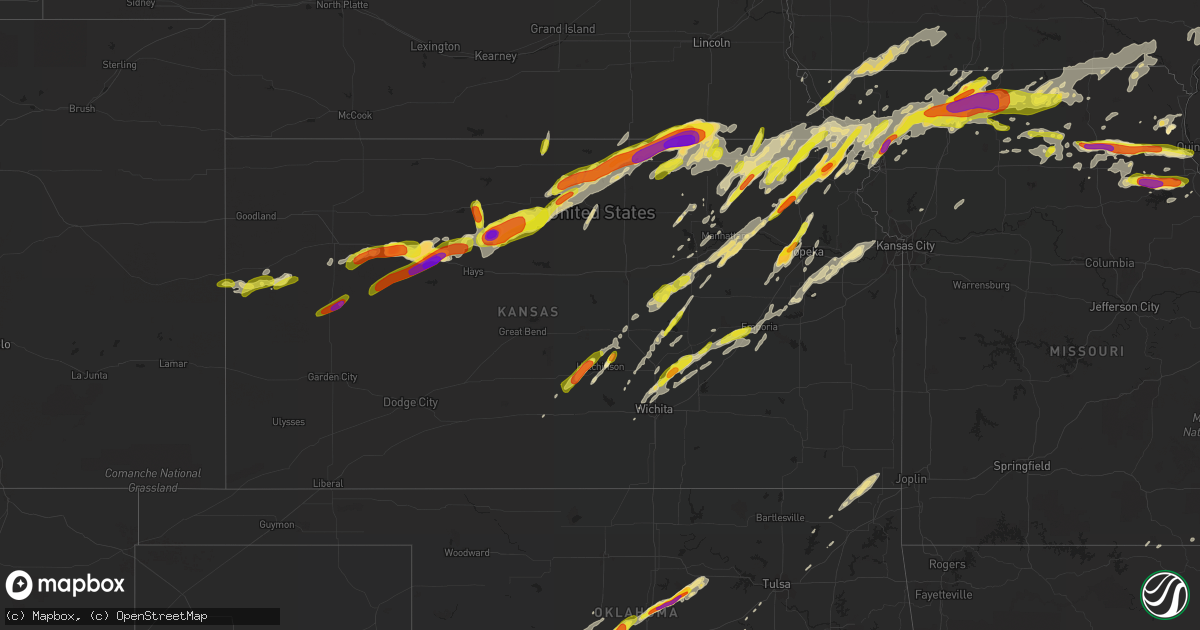
Hail Map in Kansas on May 28, 2019
Get this storm
May 28 map
$229
one time, instant access
Download today. No call, no setup
Keep the $229
Bought the map and want the full workflow? Apply the entire $229 to a subscription within 7 days. None of it is wasted.
Every map, not just this one
This buys you this map. Subscription and you get every map we run, in the markets you choose from a few cities to whole states to nationwide. Plus real-time alerts the moment a storm fires.
Contact data
Name, contact info, occupancy, even credit band for addresses in the footprint. You go from where it hit to who to call.
Become the source they trust
Unlimited branding weather history reports on demand. You already have the documented answer ready for the property owner, and you are the one who showed up with it.
Property data and RoofTrace estimates
Pull up any address you have got, its value and the exact code rules for that jurisdiction, straight from One Click Code. Then RoofTrace estimates the squares, pitch, and roof value, priced the way you price.
Storm reports in Kansas
Kansas
| Date | Description |
|---|---|
| 05/28/20196:58 PM CDT | Em reported that from ks-23 east to quinter... Hail increased from dime sized to approx. 3 inches. Time and exact location estimated from radar. |
| 05/28/20196:52 PM CDT | A local report indicates 1.50 inch wind near 1 W BELLEVILLE |
| 05/28/20196:45 PM CDT | Hail ranged from nickel to quarter sized. |
| 05/28/20196:45 PM CDT | Tornado reported by greg anstel 2 miles north of yocemento. |
| 05/28/20196:42 PM CDT | Baseball size hail reported by trego county em at rest area on i-70 east of wakeeney. |
| 05/28/20196:40 PM CDT | Relayed by by wfo gid. |
| 05/28/20196:40 PM CDT | *** 3 inj *** a nws storm survey team confirmed an ef-4 tornado... With maximum winds of 170 mph and a maximum width of 1 mile occurred tuesday evening. The storm cross |
| 05/28/20196:40 PM CDT | Ellis county em reports funnel cloud at feedlot and yocemento ave. |
| 05/28/20196:35 PM CDT | A local report indicates 1.50 inch wind near 4 N GOVE |
| 05/28/20196:26 PM CDT | Delayed report from jewell county dispatch. |
| 05/28/20196:20 PM CDT | A local report indicates a tornado near 5 S FORMOSO |
| 05/28/20196:20 PM CDT | Reports of damage and multiple vehicles overturned via lawrence police. |
| 05/28/20196:20 PM CDT | Social media photos of several homes damaged near highway 59 between pleasant grove and south lawrence. |
| 05/28/20196:17 PM CDT | Social media reporting damage on the south side of lawrence along highway 59. Major roof damage to a home. |
| 05/28/20196:17 PM CDT | Visual confirmation of large tornado on the ground. |
| 05/28/20196:17 PM CDT | Major damage to homes along 1100 road. Images from twitter. |
| 05/28/20196:17 PM CDT | Ping pong ball size hail reported. |
| 05/28/20196:15 PM CDT | Egg size hail reported by greg ansel 5miles south of wakeeney. |
| 05/28/20196:12 PM CDT | Tornado was becoming rain wrapped and difficult to see. |
| 05/28/20196:11 PM CDT | Greg ansel reports golf ball size hail 3 miles north of trego center. |
| 05/28/20196:07 PM CDT | Reported on the ground. |
| 05/28/20196:06 PM CDT | Power poles down 3 n of waldo. |
| 05/28/20195:52 PM CDT | Confirmed large tornado in progress. |
| 05/28/20195:50 PM CDT | Update from prvs report. Damage to farm equipment. Outbuildings heavily damaged. No other specifics attm. Time estd fm radar. Corrected typo. |
| 05/28/20195:45 PM CDT | Hail size range from dime to half dollar size 0.70 to 1.25. |
| 05/28/20195:38 PM CDT | Reports of quarter size hail. |
| 05/28/20195:35 PM CDT | A local report indicates 1.00 inch wind near 10 S SHARON SPRINGS |
| 05/28/20195:26 PM CDT | Tornado was still on the ground. |
| 05/28/20195:26 PM CDT | Multiple storm chasers confirm tornado in progress. Relayed by wfo ict. |
| 05/28/20195:25 PM CDT | Lasted 5 minutes. Also had .25 inches of rain. |
| 05/28/20195:21 PM CDT | Chaser reported a tornado on the ground near highway 281 and highway 18 near paradise. |
| 05/28/20195:20 PM CDT | Downed power lines. Time estimated based on radar. |
| 05/28/20195:12 PM CDT | Hail ranged from penny to quarter-sized. |
| 05/28/20195:11 PM CDT | Rotation and debris being lofted from possible tornado. Radar estimated time. |
| 05/28/20195:10 PM CDT | A local report indicates 60 MPH wind near 8 SSW WESKAN |
| 05/28/20195:00 PM CDT | Report via facebook. |
| 05/28/20194:55 PM CDT | A local report indicates 1.00 inch wind near 4 SSW SILVER LAKE |
| 05/28/20194:51 PM CDT | A local report indicates 2.00 inch wind near 3 S WILLARD |
| 05/28/20194:50 PM CDT | Corrects previous hail report from 15 sw russell springs. Report via facebook. |
| 05/28/20194:40 PM CDT | Scott county em reported hail size up to 2.25 inches in diameter on k-4... 8 miles east of hwy 83. |
| 05/28/20194:35 PM CDT | Scott county em reported quarter size hail and more copious as previous reports with some minor damage 6 miles east of hwy 83 on hwy k-4. |
| 05/28/20194:30 PM CDT | Scott county em reported ping pong size hail on hwy k-4... 4 miles east of hwy 83. |
| 05/28/20194:20 PM CDT | Ping pong ball size hail reported by scott county em at hwy 83 and road 190. |
| 05/28/20194:15 PM CDT | Landspout tornado reported by laura hedien 3 miles north of schoenchen. |
| 05/28/20193:26 PM CDT | A local report indicates 1.00 inch wind near 1 ENE RESERVE |
| 05/28/20192:56 PM CDT | A local report indicates 1.00 inch wind near 1 WNW FAIRVIEW |
| 05/28/20192:52 PM CDT | Social media photo. |
| 05/28/20192:36 PM CDT | A local report indicates 1.00 inch wind near 4 WSW WOODLAWN |
| 05/28/20192:29 PM CDT | A local report indicates 1.50 inch wind near HIGHLAND |
| 05/28/20192:13 PM CDT | A local report indicates 1.50 inch wind near 1 E WILLIS |
| 05/28/20192:13 PM CDT | Social media photos. A few hail stones up to 2.25 inches in diameter. |
| 05/28/20191:53 PM CDT | A local report indicates 1.00 inch wind near 2 N NETAWAKA |
| 05/28/20191:43 PM CDT | Social media photo. Delayed report. |
| 05/28/20191:32 PM CDT | A local report indicates 1.00 inch wind near 6 SW CIRCLEVILLE |
| 05/28/201911:43 AM CDT | Delayed report...picture received via facebook of half dollar size hail in hillsboro |
| 05/28/201911:38 AM CDT | A local report indicates 1.00 inch wind near HILLSBORO |
| 05/28/201910:14 AM CDT | A local report indicates 1.50 inch wind near BUHLER |
| 05/28/20199:43 AM CDT | Picture of ping pong ball size hail submitted via twitter. |
| 05/28/20196:53 AM CDT | At 1152 AM CDT, a severe thunderstorm was located 4 miles northwest of Lincolnville, moving northeast at 60 mph. HAZARD...60 mph wind gusts and quarter size hail. SOURCE...Radar indicated. IMPACT...Hail damage to vehicles is expected. Expect wind damage to roofs, siding, and trees. Locations impacted include... Herington, White City, Dwight, Woodbine, Parkerville and Latimer. |
| 05/28/20196:35 AM CDT | At 1135 AM CDT, a severe thunderstorm was located over Hillsboro, moving northeast at 60 mph. HAZARD...Quarter size hail. SOURCE...Radar indicated. IMPACT...Damage to vehicles is expected. Locations impacted include... Hillsboro, Lincolnville, Ramona, Lehigh, Durham, Tampa, Lost Springs, Pilsen and Marion Lake. |
| 05/28/20195:46 AM CDT | At 1046 AM CDT, a severe thunderstorm was located 7 miles southwest of Carlton, moving northeast at 55 mph. HAZARD...60 mph wind gusts and half dollar size hail. SOURCE...Radar indicated. IMPACT...Hail damage to vehicles is expected. Expect wind damage to roofs, siding, and trees. Locations impacted include... Abilene, Chapman, Enterprise, Hope, Woodbine, Carlton and Moonlight.This includes Interstate 70 between mile markers 272 and 289. |
| 05/28/20195:12 AM CDT | At 1012 AM CDT, a severe thunderstorm was located over Buhler, moving northeast at 50 mph. HAZARD...Half dollar size hail. SOURCE...Radar indicated. IMPACT...Damage to vehicles is expected. Locations impacted include... Mcpherson, Hesston, Lindsborg, Hillsboro, Moundridge, Inman, Buhler, Burrton, Galva, Canton, Goessel, Assaria, Gypsum, Lincolnville, Lehigh, Durham, Tampa, Mcpherson Airport, Roxbury and Marion Lake.This includes Interstate 135 between Mile Markers 41 and 85. |
| 05/28/20195:02 AM CDT | At 1001 PM CDT, severe thunderstorms were located along a line extending from near Shubert to 6 miles east of Falls City to near Powhattan, moving northeast at 55 mph. HAZARD...60 mph wind gusts and quarter size hail. SOURCE...Radar indicated. IMPACT...Hail damage to vehicles is expected. Expect wind damage to roofs, siding, and trees. Locations impacted include... Mound City, Highland, Oregon, Fairfax, Burlington Junction, Maitland, Skidmore, Forest City, Craig, Fillmore, White Cloud, Graham, Big Lake, Quitman, Fortescue, Bigelow, Corning and Iowa Point.This includes Interstate 29 between mile markers 65 and 102. |
| 05/28/20194:46 AM CDT | At 945 PM CDT, a severe thunderstorm was located 7 miles southwest of Verdon, or 9 miles west of Falls City, moving east at 45 mph. HAZARD...60 mph wind gusts and nickel size hail. SOURCE...Radar indicated. IMPACT...Expect damage to roofs, siding, and trees. Locations impacted include... Falls City, Verdon, Rulo, Dawson, Salem, Preston, Barada and The Highway 75 And 8 Junction. |
| 05/28/20194:40 AM CDT | At 940 AM CDT, a severe thunderstorm was located near Partridge, or 6 miles south of Nickerson, moving northeast at 55 mph. HAZARD...60 mph wind gusts and quarter size hail. SOURCE...Radar indicated. IMPACT...Hail damage to vehicles is expected. Expect wind damage to roofs, siding, and trees. Locations impacted include... Hutchinson, Mcpherson, Inman, Nickerson, Marquette, Partridge, Windom, Willowbrook and Mcpherson Airport.This includes Interstate 135 between Mile Markers 57 and 64. |
| 05/28/20193:56 AM CDT | At 856 PM CDT, a severe thunderstorm was located near Potwin, or 10 miles east of Whitewater, moving northeast at 20 mph. HAZARD...60 mph wind gusts and quarter size hail. SOURCE...Radar indicated. IMPACT...Hail damage to vehicles is expected. Expect wind damage to roofs, siding, and trees. Locations impacted include... Potwin, Burns, Cassoday, Cedar Point and Wonsevu. This includes Interstate 35 between Mile Markers 86 and 98. |
| 05/28/20193:52 AM CDT | At 851 PM CDT, severe thunderstorms were located along a line extending from 5 miles west of Summerfield to 3 miles southwest of Beattie to 8 miles southeast of Blue Rapids, moving northeast at 40 mph. HAZARD...70 mph wind gusts and ping pong ball size hail. SOURCE...Radar indicated. IMPACT...People and animals outdoors will be injured. Expect hail damage to roofs, siding, windows, and vehicles. Expect considerable tree damage. Wind damage is also likely to mobile homes, roofs, and outbuildings. Locations impacted include... Seneca, Centralia, Bern, Corning, Oneida and Baileyville. |
| 05/28/20193:41 AM CDT | At 841 PM CDT, a severe thunderstorm was located 7 miles east of Strong City, moving northeast at 45 mph. HAZARD...60 mph wind gusts and quarter size hail. SOURCE...Radar indicated. IMPACT...Hail damage to vehicles is expected. Expect wind damage to roofs, siding, and trees. Locations impacted include... Emporia, Americus, Neosho Rapids, Reading, Allen, Admire and Bushong.This includes the following highways... Interstate 35 between mile markers 128 and 143. Kansas Turnpike between mile markers 116 and 148. |
| 05/28/20193:37 AM CDT | At 837 PM CDT, a severe thunderstorm was located 7 miles southeast of Grandview Plaza, moving northeast at 45 mph. HAZARD...60 mph wind gusts and quarter size hail. SOURCE...Emergency management. IMPACT...Hail damage to vehicles is expected. Expect wind damage to roofs, siding, and trees. Locations impacted include... Manhattan, Junction City, Alma, Ogden, Grandview Plaza and Volland.This includes Interstate 70 between mile markers 293 and 327. |
| 05/28/20193:34 AM CDT | At 832 PM CDT, a severe thunderstorm was located over Wymore, or 11 miles southeast of Beatrice, moving east at 40 mph. HAZARD...60 mph wind gusts and quarter size hail. SOURCE...Radar indicated. This storm has a history of producing large hail. IMPACT...Hail damage to vehicles is expected. Expect wind damage to roofs, siding, and trees. Locations impacted include... Beatrice, Tecumseh, Wymore, Pawnee City, Blue Springs, Summerfield, Filley, Barneston, Burchard, Liberty, Steinauer, Lewiston, Virginia, Crab Orchard and Rockford State Recreation Area. |
| 05/28/20193:25 AM CDT | At 825 PM CDT, severe thunderstorms were located along a line extending from 4 miles southwest of Wymore to 4 miles west of Marysville to 4 miles northwest of Randolph, moving northeast at 45 mph. HAZARD...Golf ball size hail and 60 mph wind gusts. SOURCE...Radar indicated. IMPACT...People and animals outdoors will be injured. Expect hail damage to roofs, siding, windows, and vehicles. Expect wind damage to roofs, siding, and trees. Locations impacted include... Marysville, Blue Rapids, Frankfort, Axtell, Beattie, Randolph, Summerfield, Vermillion, Oketo and Lillis. |
| 05/28/20193:09 AM CDT | At 808 PM CDT, a severe thunderstorm was located near Florence, moving northeast at 30 mph. HAZARD...60 mph wind gusts and quarter size hail. SOURCE...Law enforcement has reported 60 mph winds and quarter sized hail in Burns. IMPACT...Hail damage to vehicles is expected. Expect wind damage to roofs, siding, and trees. Locations impacted include... Cottonwood Falls, Strong City, Florence, Bazaar, Elmdale, Matfield Green, Cedar Point, Hymer, Saffordville, Wonsevu, Tallgrass Prairie and Tallgrass Prairie Preserve.This includes Interstate 35 between Mile Markers 97 and 116. |
| 05/28/20193:05 AM CDT | At 805 PM CDT, a severe thunderstorm was located near Greenleaf, moving northeast at 45 mph. HAZARD...Golf ball size hail and 60 mph wind gusts. SOURCE...Radar indicated. IMPACT...People and animals outdoors will be injured. Expect hail damage to roofs, siding, windows, and vehicles. Expect wind damage to roofs, siding, and trees. Locations impacted include... Marysville, Washington, Blue Rapids, Hanover, Waterville, Linn, Greenleaf, Barnes, Palmer, Oketo, Hollenberg and Bremen. |
| 05/28/20192:57 AM CDT | At 757 PM CDT, a severe thunderstorm was located 8 miles south of Pawnee City, or 12 miles northwest of Seneca, moving north at 40 mph. HAZARD...Ping pong ball size hail. SOURCE...Radar indicated. IMPACT...People and animals outdoors will be injured. Expect damage to roofs, siding, windows, and vehicles. Locations impacted include... Auburn, Pawnee City, Humboldt, Peru, Johnson, Table Rock, Du Bois, Dawson, Brock, Elk Creek, Julian, 7 Miles South Of Auburn, 8 Miles South Of Johnson and Camp Cornhusker. |
| 05/28/20192:54 AM CDT | At 754 PM CDT, a severe thunderstorm was located near Wheaton, moving northeast at 40 mph. HAZARD...60 mph wind gusts and quarter size hail. SOURCE...Radar indicated. IMPACT...Hail damage to vehicles is expected. Expect wind damage to roofs, siding, and trees. Locations impacted include... Seneca, Centralia, Corning, Vermillion, Wheaton and Lillis. |
| 05/28/20192:53 AM CDT | At 753 PM CDT, a severe thunderstorm was located 6 miles northwest of Hollenberg, or 15 miles north of Washington, moving northeast at 35 mph. HAZARD...Two inch hail and 65 mph wind gusts. SOURCE...Radar indicated. IMPACT...People and animals outdoors will be injured. Expect hail damage to roofs, siding, windows, and vehicles. Expect wind damage to roofs, siding, and trees. Locations impacted include... Beatrice, Fairbury, Wymore, Blue Springs, Odell, Diller, Pickrell, Endicott, Jansen, Barneston, Liberty, Steele City, Harbine, Rock Creek Station State Historical Park, Camp Jefferson and Rockford State Recreation Area. |
| 05/28/20192:48 AM CDT | At 748 PM CDT, a severe thunderstorm was located 6 miles northwest of Wakefield, moving northeast at 45 mph. HAZARD...60 mph wind gusts and quarter size hail. SOURCE...Radar indicated. IMPACT...Hail damage to vehicles is expected. Expect wind damage to roofs, siding, and trees. Locations impacted include... Clay Center, Leonardville, Randolph and Green. |
| 05/28/20192:46 AM CDT | At 746 PM CDT, a severe thunderstorm was located 5 miles northeast of Moonlight, moving northeast at 45 mph. HAZARD...60 mph wind gusts and quarter size hail. SOURCE...Radar indicated. IMPACT...Hail damage to vehicles is expected. Expect wind damage to roofs, siding, and trees. Locations impacted include... Northern Manhattan, Wakefield, Riley, Milford, Leonardville, Milford Lake and Keats. |
| 05/28/20192:45 AM CDT | At 745 PM CDT, a severe thunderstorm was located 4 miles west of Hope, moving northeast at 40 mph. HAZARD...60 mph wind gusts and quarter size hail. SOURCE...Radar indicated. IMPACT...Hail damage to vehicles is expected. Expect wind damage to roofs, siding, and trees. Locations impacted include... Abilene, Chapman, Enterprise, Hope, Woodbine, Carlton and Moonlight.This includes Interstate 70 between mile markers 275 and 293. |
| 05/28/20192:33 AM CDT | At 733 PM CDT, severe thunderstorms were located along a line extending from 6 miles southwest of Osborne to 14 miles southeast of Alton to 9 miles northwest of Luray, moving northeast at 45 mph. HAZARD...60 mph wind gusts and half dollar size hail. SOURCE...Radar indicated. IMPACT...Hail damage to vehicles is expected. Expect wind damage to roofs, siding, and trees. Locations impacted include... Osborne, Downs, Cawker City, Glen Elder, Tipton, Hunter and Victor. |
| 05/28/20192:21 AM CDT | At 721 PM CDT, a severe thunderstorm was located near Kansas City, or near Parkville, moving east at 35 mph. HAZARD...70 mph wind gusts and ping pong ball size hail. SOURCE...Radar indicated. IMPACT...People and animals outdoors will be injured. Expect hail damage to roofs, siding, windows, and vehicles. Expect considerable tree damage. Wind damage is also likely to mobile homes, roofs, and outbuildings. Locations impacted include... Liberty, Gladstone, Smithville, Parkville, Edwardsville, North Kansas City, Riverside, Weatherby Lake, Claycomo, Kansas City, Pleasant Valley, Lake Waukomis, Glenaire, Avondale, Platte Woods, Oakview, Northmoor, Houston Lake, Oakwood Park and Oakwood.This includes the following highways... Interstate 70 in Kansas between mile markers 412 and 417. Interstate 35 in Missouri between mile markers 6 and 17. Interstate 29 between mile markers 0 and 11. Interstate 635 between mile markers 5 and 12. Interstate 435 near mile marker 11, between mile markers 13 and 24,and between mile markers 37 and 55. |
| 05/28/20192:18 AM CDT | At 718 PM CDT, a severe thunderstorm was located near Whitewater, moving northeast at 40 mph. HAZARD...60 mph wind gusts and quarter size hail. SOURCE...Radar indicated. IMPACT...Hail damage to vehicles is expected. Expect wind damage to roofs, siding, and trees. Locations impacted include... Marion, Peabody, Whitewater, Florence, Potwin, Walton, Elbing, Burns, Cassoday, Cedar Point, Newton Airport, Wonsevu and Marion Lake.This includes Interstate 35 between Mile Markers 91 and 99. |
| 05/28/20192:04 AM CDT | At 704 PM CDT, a severe thunderstorm was located 8 miles north of Emmeram, moving east at 45 mph. HAZARD...Ping pong ball size hail and 60 mph wind gusts. SOURCE...Radar indicated. IMPACT...People and animals outdoors will be injured. Expect hail damage to roofs, siding, windows, and vehicles. Expect wind damage to roofs, siding, and trees. Locations impacted include... Paradise and Waldo. |
| 05/28/20192:00 AM CDT | At 659 PM CDT, a severe thunderstorm was located 4 miles southwest of Asherville, moving northeast at 45 mph. HAZARD...Ping pong ball size hail and 60 mph wind gusts. SOURCE...Radar indicated. IMPACT...People and animals outdoors will be injured. Expect hail damage to roofs, siding, windows, and vehicles. Expect wind damage to roofs, siding, and trees. Locations impacted include... Belleville, Glasco, Scandia, Jamestown, Courtland, Norway and Republic. |
| 05/28/20192:00 AM CDT | At 700 PM CDT, severe thunderstorms were located along a line extending from 6 miles northeast of Plainville to near Codell to 7 miles southwest of Natoma, moving northeast at 35 mph. HAZARD...60 mph wind gusts and quarter size hail. SOURCE...Radar indicated. IMPACT...Hail damage to vehicles is expected. Expect wind damage to roofs, siding, and trees. Locations impacted include... Natoma, Woodston, Alton and Codell. |
| 05/28/20191:48 AM CDT | At 648 PM CDT, a severe thunderstorm was located near Barnard, or 12 miles south of Beloit, moving north at 30 mph. HAZARD...Half dollar size hail. SOURCE...Radar indicated. IMPACT...Damage to vehicles is expected. Locations impacted include... Beloit, Asherville, Simpson and Scottsville. |
| 05/28/20191:45 AM CDT | At 645 PM CDT, a severe thunderstorm was located near Park, or 5 miles west of Quinter, moving northeast at 35 mph. HAZARD...60 mph wind gusts and quarter size hail. SOURCE...Radar indicated. IMPACT...Hail damage to vehicles is expected. Expect wind damage to roofs, siding, and trees. Locations impacted include... Quinter, Grainfield, Park and Saint Peter. This includes Interstate 70 in Kansas between mile markers 92 and113. |
| 05/28/20191:30 AM CDT | At 630 PM CDT, a severe thunderstorm was located near West Wichita, or near Goddard, moving northeast at 40 mph. This storm is rapidly intensifying. HAZARD...60 mph wind gusts and half dollar size hail. SOURCE...Radar indicated. IMPACT...Hail damage to vehicles is expected. Expect wind damage to roofs, siding, and trees. Locations impacted include... Wichita, Newton, Park City, Valley Center, Bel Aire, Goddard, Hesston, Maize, Halstead, North Newton, Sedgwick, Colwich, Downtown Wichita, Kechi, Andale, Bentley, Walton, West Wichita, Eisenhower National Airport and Newton Airport.This includes Interstate 135 between Mile Markers 9 and 42. |
| 05/28/20191:28 AM CDT | At 628 PM CDT, a severe thunderstorm was located 8 miles north of Lebanon, or 39 miles northwest of Beloit, moving north at 50 mph. HAZARD...60 mph wind gusts and half dollar size hail. SOURCE...Radar indicated. IMPACT...Hail damage to vehicles is expected. Expect wind damage to roofs, siding, and trees. Locations impacted include... Red Cloud, Blue Hill, Lawrence, Guide Rock, Ayr, Deweese, Cowles and Rosemont. |
| 05/28/20191:27 AM CDT | At 627 PM CDT, a severe thunderstorm was located 9 miles south of Palco, or 12 miles northeast of Ogallah, moving northeast at 45 mph. HAZARD...60 mph wind gusts and half dollar size hail. SOURCE...Radar indicated. IMPACT...Hail damage to vehicles is expected. Expect wind damage to roofs, siding, and trees. Locations impacted include... Plainville, Palco, Woodston, Zurich and Codell. |
| 05/28/20191:16 AM CDT | At 615 PM CDT, a severe thunderstorm was located near Ogallah, moving northeast at 35 mph. HAZARD...Two inch hail and 60 mph wind gusts. SOURCE...Radar indicated. IMPACT...People and animals outdoors will be injured. Expect hail damage to roofs, siding, windows, and vehicles. Expect wind damage to roofs, siding, and trees. Locations impacted include... Ellis, Wakeeney, Ogallah and Riga. |
| 05/28/20191:14 AM CDT | At 613 PM CDT, a severe thunderstorm was located over southwestern Lawrence, moving northeast at 40 mph. HAZARD...70 mph wind gusts and quarter size hail. SOURCE...Radar indicated. IMPACT...Hail damage to vehicles is expected. Expect considerable tree damage. Wind damage is also likely to mobile homes, roofs, and outbuildings. Locations impacted include... Olathe, Shawnee, Lenexa, Bonner Springs, De Soto, Tonganoxie, Basehor, Edwardsville, Kansas City, Linwood, Reno, Fairmount, Holliday, Clearview City and Jarbalo.This includes the following highways... Interstate 435 between mile markers 3 and 6. Kansas Turnpike between mile markers 206 and 225. |
| 05/28/20191:08 AM CDT | At 607 PM CDT, a severe thunderstorm was located near Stockton, or 25 miles south of Phillipsburg, moving northeast at 25 mph. HAZARD...Golf ball size hail and 60 mph wind gusts. SOURCE...Radar indicated. IMPACT...People and animals outdoors will be injured. Expect hail damage to roofs, siding, windows, and vehicles. Expect wind damage to roofs, siding, and trees. Locations impacted include... Stockton, Kirwin, Woodston and Cedar. |
| 05/28/201912:56 AM CDT | At 556 PM CDT, a severe thunderstorm was located 10 miles south of Oakley, moving northeast at 35 mph. HAZARD...60 mph wind gusts and quarter size hail. SOURCE...Radar indicated. IMPACT...Hail damage to vehicles is expected. Expect wind damage to roofs, siding, and trees. Locations impacted include... Grainfield, Grinnell, Gove and Park. This includes Interstate 70 in Kansas between mile markers 80 and103. |
| 05/28/201912:55 AM CDT | At 555 PM CDT, a severe thunderstorm was located 10 miles south of Wallace, or 15 miles southeast of Sharon Springs, moving east at 30 mph. HAZARD...60 mph wind gusts and quarter size hail. SOURCE...Radar indicated. IMPACT...Hail damage to vehicles is expected. Expect wind damage to roofs, siding, and trees. Locations impacted include... Russell Springs. |
| 05/28/201912:28 AM CDT | At 527 PM CDT, a severe thunderstorm was located 9 miles north of Utica, moving east at 35 mph. HAZARD...Golf ball size hail and 60 mph wind gusts. SOURCE...Radar indicated. IMPACT...People and animals outdoors will be injured. Expect hail damage to roofs, siding, windows, and vehicles. Expect wind damage to roofs, siding, and trees. Locations impacted include... Wakeeney, Ogallah, Trego Center and Cedar Bluff. |
| 05/28/201912:28 AM CDT | At 527 PM CDT, a severe thunderstorm was located over Codell, or 19 miles north of Emmeram, moving north at 35 mph. HAZARD...60 mph wind gusts and half dollar size hail. SOURCE...Radar indicated. IMPACT...Hail damage to vehicles is expected. Expect wind damage to roofs, siding, and trees. Locations impacted include... Plainville, Stockton, Woodston and Codell. |
| 05/28/201912:26 AM CDT | At 526 PM CDT, a severe thunderstorm was located near Denison, or near Valley Falls, moving northeast at 45 mph. HAZARD...60 mph wind gusts and quarter size hail. SOURCE...Radar indicated. IMPACT...Hail damage to vehicles is expected. Expect wind damage to roofs, siding, and trees. Locations impacted include... Atchison, Effingham, Lancaster, Muscotah, Farmington, Huron and Arrington. |
| 05/28/201912:20 AM CDT | At 520 PM CDT, a severe thunderstorm was located over Downs, or 23 miles west of Beloit, moving northeast at 30 mph. HAZARD...Ping pong ball size hail. SOURCE...Radar indicated. IMPACT...People and animals outdoors will be injured. Expect damage to roofs, siding, windows, and vehicles. Locations impacted include... Downs, Cawker City, Esbon and Ionia. |
| 05/28/201912:15 AM CDT | At 515 PM CDT, a severe thunderstorm was located 7 miles north of Pendennis, moving east at 30 mph. HAZARD...60 mph wind gusts and half dollar size hail. SOURCE...Radar indicated. IMPACT...Hail damage to vehicles is expected. Expect wind damage to roofs, siding, and trees. This severe thunderstorm will remain over mainly rural areas of southeastern Gove County. |
| 05/27/201911:58 PM CDT | At 458 PM CDT, a severe thunderstorm was located near Hoyt, moving northeast at 50 mph. HAZARD...Two inch hail and 60 mph wind gusts. SOURCE...Emergency management. IMPACT...People and animals outdoors will be injured. Expect hail damage to roofs, siding, windows, and vehicles. Expect wind damage to roofs, siding, and trees. Locations impacted include... Topeka, Holton, Valley Falls, Rossville, Oskaloosa, Tecumseh, Dover, Silver Lake, Auburn, Meriden, Hoyt, Ozawkie, Nortonville, Winchester, Mayetta, Whiting, Denison, Delia, Netawaka and Willard.This includes the following highways... Interstate 70 between mile markers 342 and 355. Kansas Turnpike between mile markers 166 and 188. |
| 05/27/201911:54 PM CDT | At 453 PM CDT, a severe thunderstorm was located near Codell, or 10 miles north of Emmeram, moving northeast at 20 mph. HAZARD...Golf ball size hail and 60 mph wind gusts. SOURCE...Radar indicated. IMPACT...People and animals outdoors will be injured. Expect hail damage to roofs, siding, windows, and vehicles. Expect wind damage to roofs, siding, and trees. Locations impacted include... Natoma and Codell. |
| 05/27/201911:51 PM CDT | At 450 PM CDT, a severe thunderstorm was located near Emmeram, moving northeast at 35 mph. HAZARD...Golf ball size hail and 60 mph wind gusts. SOURCE...Radar indicated. IMPACT...People and animals outdoors will be injured. Expect hail damage to roofs, siding, windows, and vehicles. Expect wind damage to roofs, siding, and trees. Locations impacted include... Hays, Victoria, Walker, Catherine, Emmeram, Yocemento, Toulon and Munjor. |
| 05/27/201911:39 PM CDT | At 439 PM CDT, a severe thunderstorm was located 5 miles southeast of Admire, moving northeast at 55 mph. HAZARD...60 mph wind gusts and quarter size hail. SOURCE...Radar indicated. IMPACT...Hail damage to vehicles is expected. Expect wind damage to roofs, siding, and trees. Locations impacted include... Topeka, Osage City, Carbondale, Richland, Auburn, Overbrook, Lyndon, Burlingame, Scranton, Clinton, Lone Star, Harveyville, Reading, Admire, Pauline, Clinton Lake, Globe and Berryton.This includes Kansas Turnpike between mile markers 137 and 188. |
| 05/27/201911:36 PM CDT | At 436 PM CDT, a severe thunderstorm was located 11 miles southeast of Wallace, or 18 miles southeast of Sharon Springs, moving east at 25 mph. HAZARD...60 mph wind gusts and quarter size hail. SOURCE...Radar indicated. IMPACT...Hail damage to vehicles is expected. Expect wind damage to roofs, siding, and trees. Locations impacted include... Russell Springs. |
| 05/27/201911:33 PM CDT | At 433 PM CDT, a severe thunderstorm was located 5 miles northwest of Healy, moving northeast at 35 mph. HAZARD...60 mph wind gusts and quarter size hail. SOURCE...Radar indicated. IMPACT...Hail damage to vehicles is expected. Expect wind damage to roofs, siding, and trees. This severe thunderstorm will remain over mainly rural areas of southeastern Gove County. |
| 05/27/201911:26 PM CDT | At 425 PM CDT, a severe thunderstorm was located 8 miles west of Olpe, moving northeast at 45 mph. HAZARD...60 mph wind gusts and half dollar size hail. SOURCE...Radar indicated. IMPACT...Hail damage to vehicles is expected. Expect wind damage to roofs, siding, and trees. This severe thunderstorm will be near... Olpe around 435 PM CDT. Emporia around 440 PM CDT. Neosho Rapids around 450 PM CDT. Reading around 500 PM CDT.This includes the following highways... Interstate 35 between mile markers 128 and 143. Kansas Turnpike between mile markers 116 and 143. |
| 05/27/201911:21 PM CDT | At 420 PM CDT, a severe thunderstorm was located over Dover, moving northeast at 50 mph. HAZARD...60 mph wind gusts and quarter size hail. SOURCE...Radar indicated. IMPACT...Hail damage to vehicles is expected. Expect wind damage to roofs, siding, and trees. Locations impacted include... Topeka, Rossville, Oskaloosa, Tecumseh, Dover, Silver Lake, Auburn, Meriden, Hoyt, Ozawkie, Mayetta, Willard, Pauline, Perry Lake, Grantville, Potawatomi Reservation and Keene.This includes the following highways... Interstate 70 between mile markers 342 and 355. Kansas Turnpike between mile markers 167 and 186. |
| 05/27/201911:14 PM CDT | At 414 PM MDT, a severe thunderstorm was located 9 miles southeast of Weskan, or 12 miles southwest of Sharon Springs, moving east at 35 mph. HAZARD...60 mph wind gusts and quarter size hail. SOURCE...Radar indicated. IMPACT...Hail damage to vehicles is expected. Expect wind damage to roofs, siding, and trees. Locations impacted include... Sharon Springs, Weskan and Wallace. |
| 05/27/201911:12 PM CDT | At 412 PM CDT, a severe thunderstorm was located near Scott City, moving northeast at 30 mph. HAZARD...Golf ball size hail and 60 mph wind gusts. SOURCE...Radar indicated. IMPACT...People and animals outdoors will be injured. Expect hail damage to roofs, siding, windows, and vehicles. Expect wind damage to roofs, siding, and trees. Locations impacted include... Scott City, Grigston, Manning, Healy and Scott State Lake. |
| 05/27/201910:47 PM CDT | At 347 PM CDT, a severe thunderstorm was located near White Cloud, or 10 miles southwest of Mound City, moving east at 40 mph. HAZARD...Ping pong ball size hail and 60 mph wind gusts. SOURCE...Radar indicated. IMPACT...People and animals outdoors will be injured. Expect hail damage to roofs, siding, windows, and vehicles. Expect wind damage to roofs, siding, and trees. Locations impacted include... Mound City, Oregon, Maitland, Forest City, Fillmore, White Cloud, Graham, Big Lake, Fortescue and Bigelow.This includes Interstate 29 between mile markers 71 and 85. |
| 05/27/201910:43 PM CDT | At 342 PM CDT, a severe thunderstorm was located near Skidmore, or 10 miles north of Mound City, moving northeast at 50 mph. HAZARD...Quarter size hail. SOURCE...Radar indicated. IMPACT...Damage to vehicles is expected. Locations impacted include... Falls City, Verdon, Stella, Shubert, Rulo, Dawson, Salem, Preston, Barada, Indian Cave State Park, The Highway 75 And 8 Junction and Camp Cornhusker. |
| 05/27/201910:07 PM CDT | At 307 PM CDT, severe thunderstorms were located along a line extending from 6 miles southwest of Mound City to near Oregon to near Wathena, moving northeast at 70 mph. HAZARD...60 mph wind gusts and quarter size hail. SOURCE...Radar indicated. IMPACT...Hail damage to vehicles is expected. Expect wind damage to roofs, siding, and trees. Locations impacted include... Maryville, Savannah, Wathena, Stanberry, Mound City, Troy, Country Club Villa, Country Club, King City, Oregon, Union Star, Maitland, Amazonia, Skidmore, Forest City, Fillmore, White Cloud, Barnard, Conception Junction and Bolckow.This includes the following highways... Interstate 29 between mile markers 53 and 88. Interstate 229 between mile markers 10 and 14. |
| 05/27/20199:42 PM CDT | At 242 PM CDT, a severe thunderstorm was located over Oregon, or 9 miles southeast of Mound City, moving northeast at 55 mph. HAZARD...Half dollar size hail. SOURCE...Radar indicated. IMPACT...Damage to vehicles is expected. Locations impacted include... Oregon, Forest City, Fillmore, Barnard, Bolckow, Graham and Rosendale.This includes Interstate 29 between mile markers 66 and 78. |
| 05/27/20199:42 PM CDT | A local report indicates 60 MPH wind near CORNING |
| 05/27/20199:22 PM CDT | At 222 PM CDT, a severe thunderstorm was located over Highland, moving northeast at 60 mph. HAZARD...Ping pong ball size hail and 60 mph wind gusts. SOURCE...Radar indicated. IMPACT...People and animals outdoors will be injured. Expect hail damage to roofs, siding, windows, and vehicles. Expect wind damage to roofs, siding, and trees. Locations impacted include... Highland, Oregon, Forest City, Severance, Leona, Iowa Point and Fanning.This includes Interstate 29 between mile markers 67 and 74. |
| 05/27/20199:21 PM CDT | At 221 PM CDT, a severe thunderstorm was located near Lillis, moving northeast at 50 mph. HAZARD...60 mph wind gusts and half dollar size hail. SOURCE...Radar indicated. IMPACT...Hail damage to vehicles is expected. Expect wind damage to roofs, siding, and trees. Locations impacted include... Sabetha, Seneca, Centralia, Wetmore, Bern, Corning, Goff, Vermillion, Oneida, Baileyville, Lillis and Woodlawn. |
| 05/27/20199:13 PM CDT | At 212 PM CDT, a severe thunderstorm was located near Willis, moving northeast at 50 mph. HAZARD...60 mph wind gusts and half dollar size hail. SOURCE...Trained weather spotters. IMPACT...Hail damage to vehicles is expected. Expect wind damage to roofs, siding, and trees. Locations impacted include... Horton, Everest, Robinson and Willis. |
| 05/27/20198:47 PM CDT | At 146 PM CDT, a severe thunderstorm was located over Highland, moving northeast at 55 mph. HAZARD...60 mph wind gusts and quarter size hail. SOURCE...Radar indicated. IMPACT...Hail damage to vehicles is expected. Expect wind damage to roofs, siding, and trees. Locations impacted include... Mound City, Highland, Troy, Oregon, Maitland, Forest City, Fillmore, White Cloud, Denton, Severance, Leona, Fortescue, Bigelow, Bendena, Iowa Point and Fanning.This includes Interstate 29 between mile markers 60 and 86. |
| 05/27/20198:37 PM CDT | At 137 PM CDT, a severe thunderstorm was located 4 miles southwest of Circleville, moving northeast at 50 mph. HAZARD...60 mph wind gusts and quarter size hail. SOURCE...Radar indicated. IMPACT...Hail damage to vehicles is expected. Expect wind damage to roofs, siding, and trees. Locations impacted include... Holton, Horton, Everest, Robinson, Whiting, Circleville, Netawaka, Powhattan, Willis and Kickapoo Reservation. |
| 05/27/20198:30 PM CDT | A local report indicates 65 MPH wind near 9 S JUNCTION CITY |
| 05/27/20198:04 PM CDT | At 103 PM CDT, a severe thunderstorm was located near Wamego, moving northeast at 50 mph. HAZARD...60 mph wind gusts and quarter size hail. SOURCE...Radar indicated. IMPACT...Hail damage to vehicles is expected. Expect wind damage to roofs, siding, and trees. Locations impacted include... Wamego, St. Marys, Belvue, Emmett and Louisville. |
| 05/27/20198:01 PM CDT | Relayed report from wfo oax. |
| 05/27/20198:01 PM CDT | Also quarter size hail. |
| 05/27/20198:01 PM CDT | Also 60 mph winds. |
| 05/27/20197:37 PM CDT | Sheriffs deputy reported quarter size hail in whitewater. |
| 05/27/20197:34 PM CDT | Delayed report. Downed trees in whitewater. Courtesy of ksn. |
| 05/27/20197:34 PM CDT | Nickel to quarter sized hail. |
| 05/27/20197:31 PM CDT | . |
| 05/27/20197:08 PM CDT | Tree ripped out of ground and hwy sign crumpled like paper on interstate 70 near bonner springs. |
| 05/27/20197:06 PM CDT | One random 3 inch hail stone... Otherwise peas to quarter sized hail. |
All States Impacted by Hail Map on May 28, 2019
Cities Impacted by Hail Map on May 28, 2019
- Big Spring, TX
- Lancaster, PA
- Linden, PA
- Jersey Shore, PA
- Williamsport, PA
- Dalton, PA
- Enon Valley, PA
- Garwood, NJ
- Staten Island, NY
- Roselle, NJ
- Clark, NJ
- Linden, NJ
- Westfield, NJ
- Rahway, NJ
- Cranford, NJ
- Carteret, NJ
- Mountainside, NJ
- Hutchinson, KS
- Abbyville, KS
- Partridge, KS
- Nickerson, KS
- Columbus, KS
- Chetopa, KS
- Miami, OK
- Welch, OK
- Manchester Township, NJ
- Atlanta, MO
- Peru, NE
- Julian, NE
- Nebraska City, NE
- Brock, NE
- Fremont, MO
- Alton, MO
- Doniphan, MO
- Iowa Park, TX
- Randlett, OK
- Duncan, OK
- Foster, OK
- Konawa, OK
- Sasakwa, OK
- Tussy, OK
- Temple, OK
- Allen, OK
- Comanche, OK
- Devol, OK
- Burkburnett, TX
- Grandfield, OK
- Walters, OK
- Wynnewood, OK
- Pauls Valley, OK
- Ada, OK
- Hennepin, OK
- Elmore City, OK
- Holdenville, OK
- Davis, OK
- Marlow, OK
- Stratford, OK
- Tingley, IA
- Diagonal, IA
- Mount Ayr, IA
- Bairdford, PA
- Saxonburg, PA
- Tarentum, PA
- Mars, PA
- Cranberry Township, PA
- Warrendale, PA
- Glenshaw, PA
- Beaver Falls, PA
- Evans City, PA
- Gibsonia, PA
- Sewickley, PA
- Bakerstown, PA
- Baden, PA
- Zelienople, PA
- Russellton, PA
- Renfrew, PA
- Rochester, PA
- Cheswick, PA
- Callery, PA
- Freedom, PA
- Wexford, PA
- New Brighton, PA
- Allison Park, PA
- Valencia, PA
- Butler, PA
- Pittsburgh, PA
- East Freedom, PA
- New Enterprise, PA
- Claysburg, PA
- Portage, PA
- Duncansville, PA
- Roaring Spring, PA
- Sproul, PA
- Imler, PA
- Martinsburg, PA
- White Heath, IL
- Mansfield, IL
- Cisco, IL
- Weldon, IL
- Mahomet, IL
- Seymour, IL
- De Land, IL
- Monticello, IL
- Clubb, MO
- Silva, MO
- Greenville, MO
- Reinholds, PA
- Womelsdorf, PA
- Elverson, PA
- Wernersville, PA
- Richland, PA
- Mohnton, PA
- Morgantown, PA
- Narvon, PA
- Glenmoore, PA
- Robesonia, PA
- Birdsboro, PA
- Bernville, PA
- Reading, PA
- Ellis, KS
- Wakeeney, KS
- Ogallah, KS
- Collyer, KS
- Rush Springs, OK
- Roscoe, TX
- Sweetwater, TX
- Loraine, TX
- Scandia, KS
- Belleville, KS
- Wapakoneta, OH
- Huntsville, OH
- Belle Center, OH
- Lakeview, OH
- Jackson, MO
- Wellsville, OH
- East Liverpool, OH
- Van Wert, IA
- Grand River, IA
- Exton, PA
- Downingtown, PA
- Benton, KS
- Burns, KS
- Whitewater, KS
- Potwin, KS
- Mehoopany, PA
- Tunkhannock, PA
- Olyphant, PA
- Factoryville, PA
- Scranton, PA
- Clarks Summit, PA
- Laceyville, PA
- Moscow, PA
- Lake Ariel, PA
- Falls, PA
- Meshoppen, PA
- Belvue, KS
- Chatsworth, NJ
- North East, MD
- Charlestown, MD
- Perryville, MD
- Elkton, MD
- Manhattan, KS
- Rotan, TX
- New Galilee, PA
- Du Bois, NE
- Hiawatha, KS
- Blue Rapids, KS
- Goff, KS
- Craig, MO
- Guilford, MO
- Sabetha, KS
- Vermillion, KS
- Axtell, KS
- Amazonia, MO
- Soldier, KS
- Morrill, KS
- Olsburg, KS
- Holton, KS
- Forest City, MO
- Robinson, KS
- Fairview, KS
- Savannah, MO
- Netawaka, KS
- Rulo, NE
- Fillmore, MO
- Oneida, KS
- White Cloud, KS
- Barnard, MO
- Baileyville, KS
- Maitland, MO
- Oregon, MO
- Frankfort, KS
- Horton, KS
- Westmoreland, KS
- Falls City, NE
- Humboldt, NE
- Emmett, KS
- Bolckow, MO
- Bern, KS
- Mound City, MO
- Highland, KS
- Rosendale, MO
- Wetmore, KS
- Delia, KS
- Whiting, KS
- Centralia, KS
- Circleville, KS
- Seneca, KS
- Everest, KS
- Corning, KS
- Dawson, NE
- Latrobe, PA
- Leetsdale, PA
- Cabot, PA
- Hinckley, OH
- New Florence, PA
- Berlin Center, OH
- Greensburg, PA
- Sarver, PA
- Ebensburg, PA
- Cowansville, PA
- Monaca, PA
- Kent, OH
- Akron, OH
- Indiana, PA
- Gallitzin, PA
- Darlington, PA
- McIntyre, PA
- Creighton, PA
- Diamond, OH
- Homer City, PA
- Brush Valley, PA
- Wampum, PA
- Beloit, OH
- Woodbury, PA
- Blairsville, PA
- Spring Church, PA
- Johnstown, PA
- McGrann, PA
- Nanty Glo, PA
- Rootstown, OH
- North Benton, OH
- Hartville, OH
- South Heights, PA
- Yatesboro, PA
- Shelocta, PA
- Delmont, PA
- Portersville, PA
- Ashville, PA
- Barberton, OH
- North Apollo, PA
- Vintondale, PA
- Louisville, OH
- Aultman, PA
- Ravenna, OH
- Oakmont, PA
- Crescent, PA
- Canfield, OH
- Salineville, OH
- Saxton, PA
- McKees Rocks, PA
- Marion Center, PA
- Washingtonville, OH
- Sebring, OH
- Chicora, PA
- North Jackson, OH
- Youngstown, OH
- Medina, OH
- New Springfield, OH
- Apollo, PA
- Ford Cliff, PA
- Sidman, PA
- Clinton, PA
- Avonmore, PA
- Munroe Falls, OH
- Freeport, PA
- Rogers, OH
- Export, PA
- Uniontown, OH
- Fenelton, PA
- James Creek, PA
- Negley, OH
- Bridgeville, PA
- West Lebanon, PA
- Coraopolis, PA
- Beaver, PA
- Lakemore, OH
- Harmony, PA
- Deerfield, OH
- West Mifflin, PA
- Newry, PA
- Indianola, PA
- Coral, PA
- Josephine, PA
- Saltsburg, PA
- Ellwood City, PA
- Fombell, PA
- Leetonia, OH
- Rural Valley, PA
- Midland, PA
- Starford, PA
- Lisbon, OH
- Cuyahoga Falls, OH
- New Waterford, OH
- Springdale, PA
- Pulaski, PA
- Carnegie, PA
- Edinburg, PA
- Limaville, OH
- Natrona Heights, PA
- Vandergrift, PA
- Slippery Rock, PA
- Commodore, PA
- New Kensington, PA
- Bradfordwoods, PA
- Heilwood, PA
- East Palestine, OH
- Hanoverton, OH
- Slickville, PA
- Williamsburg, PA
- Damascus, OH
- Brackenridge, PA
- Home, PA
- Connoquenessing, PA
- Tallmadge, OH
- Ambridge, PA
- Black Lick, PA
- Clymer, PA
- Lyndora, PA
- Koppel, PA
- Mineral Point, PA
- East Butler, PA
- Presto, PA
- New Alexandria, PA
- Conway, PA
- Twin Rocks, PA
- Petersburg, OH
- New Derry, PA
- Summerhill, PA
- Harwick, PA
- Industry, PA
- North Canton, OH
- New Castle, PA
- Penn Run, PA
- Seward, PA
- East Rochester, OH
- Ford City, PA
- Northern Cambria, PA
- Braddock, PA
- Hillsville, PA
- Campbell, OH
- Carrolltown, PA
- Clarksburg, PA
- Leechburg, PA
- North Lima, OH
- Lake Milton, OH
- Columbiana, OH
- Loretto, PA
- Derry, PA
- Salem, OH
- Bessemer, PA
- Elderton, PA
- Manorville, PA
- Clune, PA
- Mogadore, OH
- Homestead, PA
- Worthington, PA
- Brunswick, OH
- Prospect, PA
- Colver, PA
- Canton, OH
- Belsano, PA
- Aliquippa, PA
- Oakdale, PA
- Hollidaysburg, PA
- Cresson, PA
- Dilltown, PA
- Alliance, OH
- Struthers, OH
- Lucernemines, PA
- Kittanning, PA
- Valley City, OH
- Ernest, PA
- Atwater, OH
- Creekside, PA
- Crabtree, PA
- Dixonville, PA
- Verona, PA
- Murrysville, PA
- South Fork, PA
- Lilly, PA
- Lowellville, OH
- Nicktown, PA
- Sagamore, PA
- Adrian, PA
- Mentcle, PA
- Armagh, PA
- Strongstown, PA
- Pawnee City, NE
- Yukon, OK
- Edmond, OK
- Cashion, OK
- El Reno, OK
- Okarche, OK
- Piedmont, OK
- Berwick, IL
- Kirkwood, IL
- Roseville, IL
- Cameron, IL
- Smithshire, IL
- Stronghurst, IL
- Raritan, IL
- Biggsville, IL
- Media, IL
- Monmouth, IL
- Clarion, PA
- Sligo, PA
- Perkins, OK
- Stillwater, OK
- Toms River, NJ
- Alexandria, PA
- Altoona, PA
- Tyrone, PA
- Atoka, OK
- Coleman, OK
- Kenefic, OK
- Green City, MO
- Unionville, MO
- Murray, IA
- Steele City, NE
- Mahaska, KS
- Esbon, KS
- Randall, KS
- Waldo, KS
- Paradise, KS
- Formoso, KS
- Plainville, KS
- Marysville, KS
- Luray, KS
- Beloit, KS
- Morrowville, KS
- Odell, NE
- Courtland, KS
- Fairbury, NE
- Bremen, KS
- Haddam, KS
- Jewell, KS
- Beatrice, NE
- Natoma, KS
- Cawker City, KS
- Glen Elder, KS
- Diller, NE
- Linn, KS
- Clifton, KS
- Osborne, KS
- Alton, KS
- Cuba, KS
- Endicott, NE
- Blue Springs, NE
- Mankato, KS
- Narka, KS
- Norway, KS
- Tipton, KS
- Washington, KS
- Munden, KS
- Downs, KS
- Hanover, KS
- Hollenberg, KS
- Wymore, NE
- Geneva, IN
- Stanton, TX
- Fisher, IL
- Gibson City, IL
- Dewey, IL
- Thomasboro, IL
- Ludlow, IL
- Champaign, IL
- Paxton, IL
- Rantoul, IL
- Valley Center, KS
- Sandy Lake, PA
- Lickingville, PA
- Cooksburg, PA
- Clarington, PA
- Tionesta, PA
- Fryburg, PA
- Vowinckel, PA
- Lucinda, PA
- Sigel, PA
- Venus, PA
- Leeper, PA
- Strattanville, PA
- Brookville, PA
- Ringtown, PA
- Shenandoah, PA
- Catawissa, PA
- Elysburg, PA
- Wilburton, PA
- Brashear, MO
- Hurdland, MO
- Baring, MO
- Mifflinburg, PA
- Stoneboro, PA
- Polk, PA
- Fredonia, PA
- Clarks Mills, PA
- Cheyenne Wells, CO
- Pinckneyville, IL
- Lomax, IL
- Scott City, KS
- Saint Georges, DE
- New Castle, DE
- Delaware City, DE
- Salem, NJ
- Middletown, DE
- Bear, DE
- Newark, DE
- Hope, KS
- Arapahoe, CO
- Newton, KS
- Mill Creek, PA
- Huntingdon, PA
- Orbisonia, PA
- McVeytown, PA
- Oakley, KS
- Tonganoxie, KS
- Linwood, KS
- Lawrence, KS
- Pleasantville, PA
- Kokomo, IN
- Manahawkin, NJ
- Barnegat, NJ
- Waynesfield, OH
- Lima, OH
- Uniopolis, OH
- Coyle, OK
- Bloomfield, IA
- Bendena, KS
- Troy, KS
- Overbrook, KS
- Carbondale, KS
- Scranton, KS
- Berryton, KS
- Alma, KS
- Topeka, KS
- Sugar Run, PA
- Wyalusing, PA
- New Albany, PA
- Nottingham, PA
- Peach Bottom, PA
- New London, MO
- Center, MO
- Mcalester, OK
- Indiahoma, OK
- Wallace, KS
- Cottonwood Falls, KS
- Braddyville, IA
- North Bend, PA
- Lock Haven, PA
- Lawton, OK
- Flinton, PA
- Fallentimber, PA
- La Harpe, IL
- Albia, IA
- Dallas City, IL
- Osceola, IA
- Keosauqua, IA
- Continental, OH
- Miller City, OH
- Ottawa, OH
- Leipsic, OH
- Calverton, NY
- Purcell, OK
- Montandon, PA
- Lewisburg, PA
- Milton, PA
- Elizabeth, NJ
- Newark, NJ
- Quinter, KS
- Maple Hill, KS
- Russell, IA
- Chariton, IA
- Pulaski, IA
- Guthrie, OK
- Osage City, KS
- Lyndon, KS
- Midland, TX
- Parker, PA
- Harrisville, PA
- Boyers, PA
- Petrolia, PA
- Hilliards, PA
- West Burlington, IA
- Burlington, IA
- Sperry, IA
- Pennsville, NJ
- Templeton, PA
- Westover, PA
- Coalport, PA
- Hastings, PA
- Glen Campbell, PA
- Patton, PA
- La Jose, PA
- Cherry Tree, PA
- Concordia, KS
- Jamestown, KS
- Sharon Springs, KS
- Penns Grove, NJ
- Wilmington, DE
- Alloway, NJ
- Shiloh, NJ
- Woodstown, NJ
- Bridgeton, NJ
- Speer, IL
- Gracemont, OK
- Brookfield, MO
- Blythedale, MO
- Ridgeway, MO
- Cainsville, MO
- Richmond, MO
- Rayville, MO
- Polo, MO
- Cowgill, MO
- Whitefield, OK
- Stigler, OK
- Oakwood, OH
- Mercer, PA
- Grove City, PA
- Bruin, PA
- West Sunbury, PA
- Remsenburg, NY
- Speonk, NY
- Paris, MO
- Shelbina, MO
- Memphis, MO
- Arbela, MO
- Morris Plains, NJ
- Hammonton, NJ
- Cantril, IA
- Leonard, MO
- Shelbyville, MO
- Bethel, MO
- Weldon, IA
- Cutler, IN
- Bringhurst, IN
- Rossville, IN
- Browning, IL
- Havana, IL
- Astoria, IL
- Burr Oak, KS
- Red Cloud, NE
- Lebanon, KS
- Strasburg, PA
- Manheim, PA
- Gordonville, PA
- Smoketown, PA
- Ronks, PA
- Bird In Hand, PA
- Paradise, PA
- East Petersburg, PA
- Lititz, PA
- Fletcher, OK
- East Stroudsburg, PA
- Blairstown, NJ
- Columbia, NJ
- Catlin, IL
- Tilton, IL
- Oakwood, IL
- Fithian, IL
- Covington, IN
- Fairmount, IL
- Danville, IL
- Harrod, OH
- Havensville, KS
- Dwight, KS
- Alta Vista, KS
- Wamego, KS
- Junction City, KS
- Saint Marys, KS
- Clearfield, IA
- Argenta, IL
- Novelty, MO
- La Plata, MO
- Eufaula, OK
- Berne, IN
- Rockford, OH
- Bryant, IN
- Celina, OH
- Keystone, IN
- Coldwater, OH
- Tecumseh, NE
- Cook, NE
- Steinauer, NE
- Elk Creek, NE
- Imboden, AR
- Sheppard Afb, TX
- Wichita Falls, TX
- Rockton, PA
- Cassville, PA
- Mapleton Depot, PA
- Cache, OK
- Fort Sill, OK
- Honey Brook, PA
- Hinton, OK
- Darlington, MO
- Albany, MO
- McFall, MO
- Gilman City, MO
- Rea, MO
- Stanberry, MO
- Princeton, MO
- King City, MO
- Eagleville, MO
- Union Star, MO
- Bethany, MO
- New Hampton, MO
- Kermit, TX
- Cross Fork, PA
- Monroe, CT
- Ansonia, CT
- Orange, CT
- Woodbridge, CT
- Shelton, CT
- New Haven, CT
- Derby, CT
- Newtown, CT
- West Haven, CT
- Keansburg, NJ
- Calvin, OK
- Clay Center, KS
- Knox, PA
- Shamokin, PA
- Klingerstown, PA
- Leck Kill, PA
- Dornsife, PA
- Selinsgrove, PA
- Paxinos, PA
- Middleburg, PA
- Winfield, PA
- Sunbury, PA
- Trevorton, PA
- Shamokin Dam, PA
- Rebuck, PA
- Goldsmith, TX
- Ripley, OK
- Monticello, MO
- Lewistown, MO
- Weskan, KS
- Stevensville, PA
- Monroeville, IN
- Woodburn, IN
- New Haven, IN
- Fort Wayne, IN
- Coahoma, TX
- Glencoe, OK
- Yale, OK
- Roby, TX
- Sylvester, TX
- Arriba, CO
- Emporia, KS
- Mccurtain, OK
- Bokoshe, OK
- Sheffield, PA
- Knoxville, IL
- Gilson, IL
- Glen Mills, PA
- Garnet Valley, PA
- Chadds Ford, PA
- Hermitage, PA
- Westboro, MO
- Tarkio, MO
- Gravity, IA
- New Market, IA
- Bedford, IA
- Blanchard, IA
- Shannon City, IA
- Shubert, NE
- Clarinda, IA
- Nemaha, NE
- Hopkins, MO
- Sharpsburg, IA
- Lenox, IA
- Clearmont, MO
- Elmo, MO
- Rock Port, MO
- Fairfax, MO
- Convoy, OH
- Oley, PA
- Douglassville, PA
- Gibbs, MO
- Fort Riley, KS
- Riley, KS
- McCaulley, TX
- Trent, TX
- Westbrook, TX
- Colorado City, TX
- Lincolnville, KS
- Lost Springs, KS
- Landisville, PA
- Leola, PA
- Parkesburg, PA
- Cochranville, PA
- Christiana, PA
- Atglen, PA
- Quarryville, PA
- Elgin, OK
- Green Valley, IL
- Pekin, IL
- Lawrenceville, IL
- Vincennes, IN
- Apache, OK
- Urbana, IN
- Andrews, IN
- Lenorah, TX
- Knott, TX
- Kellyville, OK
- Milford, IL
- Onarga, IL
- Ritzville, WA
- Sewell, NJ
- Lovilia, IA
- Yarmouth, IA
- Middletown, IA
- Danville, IA
- New London, IA
- Barstow, TX
- Monahans, TX
- Pyote, TX
- Mill Hall, PA
- Chelsea, OK
- Tremont, IL
- Fowler, IN
- Claymont, DE
- Pedricktown, NJ
- Swedesboro, NJ
- Pollock, MO
- Milan, MO
- Muldrow, OK
- Sallisaw, OK
- Holliday, TX
- Byers, TX
- Petrolia, TX
- Electra, TX
- Cammal, PA
- Manito, IL
- Canton, IL
- Glasford, IL
- Beattie, KS
- Home, KS
- Maywood, MO
- Ewing, MO
- Palmyra, MO
- Philadelphia, MO
- Emden, MO
- Taylor, MO
- Andrews, TX
- Gardendale, TX
- Odessa, TX
- La Belle, MO
- Madison, MO
- Anabel, MO
- Holliday, MO
- Hannibal, MO
- Lentner, MO
- Hunnewell, MO
- Stoutsville, MO
- Clarence, MO
- Monroe City, MO
- Olpe, KS
- Madison, KS
- Hartford, KS
- Wildwood, NJ
- Cape May Court House, NJ
- Haddonfield, NJ
- Cherry Hill, NJ
- Decker, IN
- Mount Carmel, IL
- New Columbia, PA
- Loganton, PA
- Saint Marys, OH
- Kelleys Island, OH
- Rehrersburg, PA
- Maryville, MO
- Fredericksburg, OH
- Millersburg, OH
- Shoals, IN
- New Cambria, MO
- Callao, MO
- Mcpherson, KS
- Denton, KS
- Shreve, OH
- Bradley, OK
- Lindsay, OK
- Clinton, AR
- Leslie, AR
- Lagro, IN
- Huntington, IN
- Elbing, KS
- Arcadia, PA
- Blandburg, PA
- Hillsdale, PA
- Delavan, IL
- Hopedale, IL
- Ethel, MO
- Ramona, KS
- Marion, KS
- Good Hope, IL
- Sciota, IL
- Jackson Center, PA
- Kennerdell, PA
- Marienville, PA
- Montgomery, IN
- Pitman, PA
- New Berlin, PA
- Hegins, PA
- Chesapeake City, MD
- Strong City, KS
- Milton, IA
- Leon, IA
- Woodburn, IA
- Blackwood, NJ
- Mantua, NJ
- Cedar Point, KS
- Morris, PA
- Cedar Run, PA
- Forked River, NJ
- Cunningham, KS
- Pratt, KS
- Saint Paul, AR
- Combs, AR
- Hill City, KS
- Park, KS
- Halstead, KS
- Chillicothe, MO
- Chula, MO
- Loveland, OK
- Chattanooga, OK
- Utica, PA
- Lorain, OH
- Mount Union, IA
- Mount Pleasant, IA
- Goldsmith, IN
- Tipton, IN
- Frankfort, IN
- Russiaville, IN
- Coffey, MO
- Bayville, NJ
- Lanoka Harbor, NJ
- Faxon, OK
- Marietta, IL
- Pocola, OK
- Spiro, OK
- Fort Smith, AR
- Arkoma, OK
- Simpson, KS
- Asher, OK
- Leesburg, NJ
- Newport, NJ
- Cedarville, NJ
- Port Norris, NJ
- Heislerville, NJ
- Millville, NJ
- Delmont, NJ
- Tamiment, PA
- Bushkill, PA
- Hillsboro, IN
- Grandin, MO
- Austin, PA
- Waterville, PA
- Allenwood, PA
- Montgomery, PA
- Renovo, PA
- Winigan, MO
- Browning, MO
- Green Castle, MO
- Linneus, MO
- New Boston, MO
- Bucklin, MO
- Purdin, MO
- Humphreys, MO
- Denison, KS
- Auburn, KS
- Harveyville, KS
- Silver Lake, KS
- Hoyt, KS
- Mayetta, KS
- Sedgwick, KS
- Peabody, KS
- Florence, KS
- Melrose, IA
- Monroeville, PA
- Henryville, PA
- Cannelburg, IN
- Loogootee, IN
- Stow, OH
- Peninsula, OH
- Hudson, OH
- Bowling Green, OH
- Palco, KS
- Elmdale, KS
- Nicholson, PA
- Springville, PA
- Vincentown, NJ
- Pine Grove, PA
- Tremont, PA
- Valley View, PA
- Elmwood, IL
- Williamsfield, IL
- Smithville, AR
- Black Rock, AR
- Spickard, MO
- Northumberland, PA
- Franklin, PA
- Wathena, KS
- Saint Joseph, MO
- Kenilworth, NJ
- Springfield, NJ
- Scotch Plains, NJ
- Roselle Park, NJ
- Colonia, NJ
- Kennett Square, PA
- Cassoday, KS
- Wabash, IN
- Stanhope, NJ
- Andover, NJ
- Quinton, OK
- Porum, OK
- Checotah, OK
- Quogue, NY
- Westhampton Beach, NY
- Rochester Mills, PA
- Pickering, MO
- Inman, KS
- Red Oak, IA
- Stanton, IA
- Essex, IA
- Gepp, AR
- Frederick, OK
- Hollister, OK
- Thayer, IA
- Ellston, IA
- Gypsum, KS
- Ninnekah, OK
- Tarzan, TX
- Canton, PA
- Eastport, NY
- Westhampton, NY
- Indianola, OK
- Crowder, OK
- Webbers Falls, OK
- Canadian, OK
- Hermleigh, TX
- Snyder, TX
- Laurelton, PA
- Sacramento, PA
- Rebersburg, PA
- Millmont, PA
- Muir, PA
- Tower City, PA
- Skidmore, MO
- Burlington Junction, MO
- Filley, NE
- Intercourse, PA
- Washington Boro, PA
- Gap, PA
- Elizabethtown, PA
- Mountville, PA
- Wrightsville, PA
- Kinzers, PA
- York, PA
- West Grove, PA
- Mount Joy, PA
- Columbia, PA
- Coatesville, PA
- Winona, KS
- Macomb, IL
- Herington, KS
- Liberty, NE
- Abilene, KS
- Burchard, NE
- Onaga, KS
- Clyde, KS
- Lancaster, MO
- Kirksville, MO
- Douds, IA
- Enterprise, KS
- Gorham, KS
- Durham, KS
- Waterville, KS
- Lucerne, MO
- Martinsville, MO
- Conception Junction, MO
- Trenton, MO
- Victoria, KS
- Novinger, MO
- Harris, MO
- Bonaparte, IA
- Stockport, IA
- Graham, MO
- Luray, MO
- Galt, MO
- Stockton, KS
- Livonia, MO
- Denver, MO
- Catharine, KS
- Helena, MO
- Verdon, NE
- Conception, MO
- Greenleaf, KS
- Oketo, KS
- Saint George, KS
- Mount Sterling, IA
- Exline, IA
- Moulton, IA
- Barnes, KS
- Newtown, MO
- Glenwood, MO
- Salem, NE
- Birmingham, IA
- Woodbine, KS
- Chapman, KS
- Downing, MO
- Worthington, MO
- Coatsville, MO
- Gentry, MO
- Agenda, KS
- Pattonsburg, MO
- Greentop, MO
- Farmington, IA
- Tampa, KS
- Pawnee, OK
- Maramec, OK
- Calumet, OK
- Maize, KS
- Admire, KS
- Kechi, KS
- Wichita, KS
- Matfield Green, KS
- Reading, KS
- Vinita, OK
- Bluejacket, OK
- Lakehurst, NJ
- Danville, PA
- Beech Creek, PA
- Herndon, PA
- West Milton, PA
- Beach City, OH
- Dundee, OH
- Wilmot, OH
- Saybrook, IL
- Penfield, IL
- Saint Joseph, IL
- Ogden, IL
- Foosland, IL
- Urbana, IL
- Bondville, IL
- Arrowsmith, IL
- Bellflower, IL
- Columbus Grove, OH
- Cogan Station, PA
- Afton, IA
- Twinsburg, OH
- Miller Place, NY
- Middle Island, NY
- Ashwood, OR
- Poplar Bluff, MO
- Ellsinore, MO
- Bristow, OK
- Decatur, IN
- Grinnell, KS
- Grainfield, KS
- Gove, KS
- East Hanover, NJ
- Wharton, NJ
- Kenvil, NJ
- Whippany, NJ
- Randolph, NJ
- Dover, NJ
- Parsippany, NJ
- Denville, NJ
- Cedar Knolls, NJ
- La Fontaine, IN
- Leopold, MO
- West Middlesex, PA
- Bayonne, NJ
- Jersey City, NJ
- Ottumwa, IA
- Unionville, IA
- Moravia, IA
- Blakesburg, IA
- Kellerton, IA
- Dravosburg, PA
- Greenock, PA
- Clairton, PA
- Mckeesport, PA
- Elizabeth, PA
- Duquesne, PA
- Glassport, PA
- Irwin, PA
- Geary, OK
- Brockway, PA
- Alex, OK
- Lexington, OK
- Noble, OK
- Maysville, OK
- Byars, OK
- New Virginia, IA
- Abingdon, IL
- Saint Augustine, IL
- Higden, AR
- Drasco, AR
- Heber Springs, AR
- Buhler, KS
- Smithfield, IL
- Cuba, IL
- Lewistown, IL
- London Mills, IL
- Saint David, IL
- Topeka, IL
- Table Grove, IL
- South Pekin, IL
- Norris, IL
- Avon, IL
- Farmington, IL
- Bryant, IL
- Fairview, IL
- Groveland, IL
- Ellisville, IL
- Prosser, WA
- Benton City, WA
- Ellensburg, WA
- Kingfisher, OK
- Elmer, MO
- Newark, MO
- Marion, IN
- Watsontown, PA
- Short Hills, NJ
- Maplewood, NJ
- Landing, NJ
- Morristown, NJ
- Irvington, NJ
- Livingston, NJ
- West Orange, NJ
- Hopatcong, NJ
- Florham Park, NJ
- Millburn, NJ
- Mine Hill, NJ
- Rockaway, NJ
- Mount Tabor, NJ
- Mount Arlington, NJ
- South Orange, NJ
- Bethel, PA
- Myerstown, PA
- Bolivar, PA
- Salem, IA
- Rupert, ID
- Port Deposit, MD
- North Ridgeville, OH
- North Olmsted, OH
- Avon, OH
- Bay Village, OH
- Westlake, OH
- Sheffield Lake, OH
- Seminole, PA
- New Bethlehem, PA
- North Versailles, PA
- Moxee, WA
- Farragut, IA
- Frederick, IL
- Philipsburg, PA
- Stanford, IL
- Randolph, KS
- Mountain View, AR
- Hockessin, DE
- Landenberg, PA
- Mahaffey, PA
- Turbotville, PA
- Muncy, PA
- Seymour, TX
- Shenandoah, IA
- Cleveland, OH
- Strongsville, OH
- Riverton, IA
- Ratliff City, OK
- Laredo, MO
- Perry, MO
- Corsica, PA
- Humeston, IA
- Decatur, IA
- Lamoni, IA
- Curwensville, PA
- Oxford, PA
- Kenton, OH
- Dysart, PA
- Hatfield, MO
- Eskridge, KS
- Hanna, OK
- Auburn, NE
- Brownville, NE
- Titusville, PA
- Tamaroa, IL
- Maud, OK
- Macomb, OK
- Wanette, OK
- Atlantic, PA
- Olmsted Falls, OH
- Effingham, KS
- Muscotah, KS
- Peoria, IL
- Liverpool, IL
- Trivoli, IL
- Adair, IL
- Hanna City, IL
- Galesburg, IL
- Bushnell, IL
- Morton, IL
- Prairie City, IL
- Bardolph, IL
- Carman, IL
- Oquawka, IL
- Mapleton, IL
- Kingston Mines, IL
- Forest City, IL
- Gladstone, IL
- Viola, AR
- Moody, MO
- West Plains, MO
- North Royalton, OH
- Kensington, OH
- Three Springs, PA
- Cooperstown, PA
- Cochranton, PA
- North Manchester, IN
- Leesport, PA
- Green, KS
- Bussey, IA
- Knoxville, IA
- Hamilton, IA
- Washington, IN
- White City, KS
- Batesville, AR
- Hesston, KS
- Goessel, KS
- Moundridge, KS
- Hillsboro, KS
- Napoleon, OH
- Defiance, OH
- Holgate, OH
- Delphi, IN
- Oil City, PA
- Alexis, IL
- Gerlaw, IL
- Sterling, PA
- Jessup, PA
- Towanda, PA
- Wysox, PA
- Thayer, MO
- Couch, MO
- Cosby, MO
- Easton, MO
- Danbury, CT
- Bethel, CT
- Hiram, OH
- Mantua, OH
- Chagrin Falls, OH
- McComb, OH
- Paulding, OH
- Chester, NE
- Hebron, NE
- Beardstown, IL
- Pettigrew, AR
- Garden City, TX
- Notrees, TX
- Mount Hope, KS
- East Earl, PA
- Tecumseh, KS
- Newton, NJ
- Fairmount City, PA
- Hadley, PA
- Summerville, PA
- Mayport, PA
- Emlenton, PA
- Claremore, OK
- Solon, OH
- Chester, PA
- Wallingford, PA
- Brookhaven, PA
- Aston, PA
- Woodlyn, PA
- Mercer, MO
- Lineville, IA
- Parkersburg, IL
- Olney, IL
- Troy, PA
- Vandalia, IL
- Greenville, IL
- Keyesport, IL
- Manorville, NY
- East Moriches, NY
- Irvona, PA
- Macon, MO
- Bevier, MO
- Boyertown, PA
- Vienna, OH
- Warren, OH
- Strasburg, OH
- Holmesville, OH
- Armington, IL
- Minier, IL
- Leonardville, KS
- Karval, CO
- Sapulpa, OK
- Knox City, MO
- Oxford, CT
- Marlton, NJ
- Wakefield, KS
- Salem, AR
- Coyanosa, TX
- Pitman, NJ
- Clarksboro, NJ
- Gibbstown, NJ
- Mickleton, NJ
- Wenonah, NJ
- Clarksdale, MO
- Amity, MO
- Craigville, IN
- Roann, IN
- Warren, IN
- Peru, IN
- Ossian, IN
- Markle, IN
- Van Buren, IN
- Bluffton, IN
- Denver, IN
- Uniondale, IN
- Potomac, IL
- Rossville, IL
- Benton, IA
- Pine Beach, NJ
- Seaside Park, NJ
- Browns Mills, NJ
- Island Heights, NJ
- Pemberton, NJ
- Beachwood, NJ
- Farmer City, IL
- Hillsboro, IA
- Downs, IL
- Le Roy, IL
- New Wilmington, PA
- Pemberville, OH
- Woodville, OH
- Gibsonburg, OH
- Maple Heights, OH
- Talmage, NE
- Yakima, WA
- Veedersburg, IN
- Carey, OH
- McCutchenville, OH
- Rising Sun, MD
- Wakarusa, KS
- Deer, AR
- Dorchester, NJ
- Avondale, PA
- Woodbine, NJ
- Lincoln University, PA
- Bedford, OH
- Brecksville, OH
- Northfield, OH
- Macedonia, OH
- Independence, OH
- Broadview Heights, OH
- Ellery, IL
- Golden Gate, IL
- Albion, IL
- Goddard, KS
- Lake Hopatcong, NJ
- Mechanicstown, OH
- Carrollton, OH
- Temple, PA
- Eldon, IA
- Dellroy, OH
- Mineral City, OH
- Corning, IA
- Canton, MO
- Williamstown, MO
- Port Clinton, OH
- Ridge, NY
- Riverhead, NY
- East Quogue, NY
- Anson, TX
- Greenville, PA
- Lewiston, NE
- Fort Jennings, OH
- West Chester, PA
- Newmanstown, PA
- New Vernon, NJ
- Green Village, NJ
- Chatham, NJ
- Mendham, NJ
- Flanders, NJ
- Hackettstown, NJ
- Basking Ridge, NJ
- Succasunna, NJ
- Chester, NJ
- Budd Lake, NJ
- Todd, PA
- Oark, AR
- Plevna, KS
- Turon, KS
- Arlington, KS
- Eddyville, IA
- Big Prairie, OH
- Lakeville, OH
- Volant, PA
- Karns City, PA
- Rimersburg, PA
- Mohrsville, PA
- Lamar, PA
- New Holland, PA
- Strausstown, PA
- Thorndale, PA
- Schuylkill Haven, PA
- Canadensis, PA
- Greentown, PA
- Newfoundland, PA
- Cresco, PA
- Vauxhall, NJ
- Hillside, NJ
- Union, NJ
- Meriden, KS
- Grantville, KS
- Hamburg, IA
- Concord, AR
- Pottstown, PA
- Locust Grove, AR
- Wheeling, MO
- Reno, PA
- Seneca, PA
- Guys Mills, PA
- Douglas, NE
- Sterling, NE
- Burr, NE
- Amboy, IN
- Summitville, OH
- Vian, OK
- Waynetown, IN
- Dover, OH
- Perrysville, IN
- Fawn Grove, PA
- Delta, PA
- Drumore, PA
- Hector, AR
- Dennard, AR
- Oskaloosa, IA
- Findlay, OH
- Alvada, OH
- Bonner Springs, KS
- Basehor, KS
- Burlingame, KS
- Eudora, KS
- Spencerville, OH
- Mendon, OH
- Davis City, IA
- Darlington, IN
- West Point, IA
- Loudonville, OH
- Clinton, IL
- Maroa, IL
- Patterson, MO
- Gatewood, MO
- Aurora, OH
- Kinta, OK
- Jamestown, PA
- Alvin, IL
- Gouldsboro, PA
- Tobyhanna, PA
- South Hutchinson, KS
- Princeville, IL
- Toulon, IL
- Vassar, KS
- Quenemo, KS
- Jamesport, MO
- Moosic, PA
- Taylor, PA
- Pittston, PA
- Hookstown, PA
- Durham, MO
- Montrose, PA
- Gipsy, PA
- Punxsutawney, PA
- Rossiter, PA
- Drakesville, IA
- Holt, MO
- Kearney, MO
- Owensville, IN
- Davidson, OK
- Roland, OK
- Keota, OK
- Cameron, OK
- Van Buren, AR
- Atlanta, IL
- Burrton, KS
- Wheatland, PA
- Farrell, PA
- Sharon, PA
- Hubbard, OH
- Masury, OH
- Calhoun, IL
- Nowata, OK
- Galva, KS
- Quitman, AR
- Carbondale, PA
- Jermyn, PA
- Quincy, IL
- Meadville, PA
- Hartstown, PA
- Conneaut Lake, PA
- Ohio City, OH
- Willshire, OH
- Wren, OH
- Anadarko, OK
- Cranberry, PA
- Shippenville, PA
- Elk Mills, MD
- Malvern, PA
- Grenloch, NJ
- Tipton, PA
- Nodaway, IA
- Lucas, IA
- Villisca, IA
- Derby, IA
- Marienthal, KS
- Healy, KS
- Dighton, KS
- Hays, KS
- Tribune, KS
- Reynolds, NE
- Payne, OH
- Fort Recovery, OH
- Rushville, IL
- Lane, IL
- Ipava, IL
- Blanchard, OK


