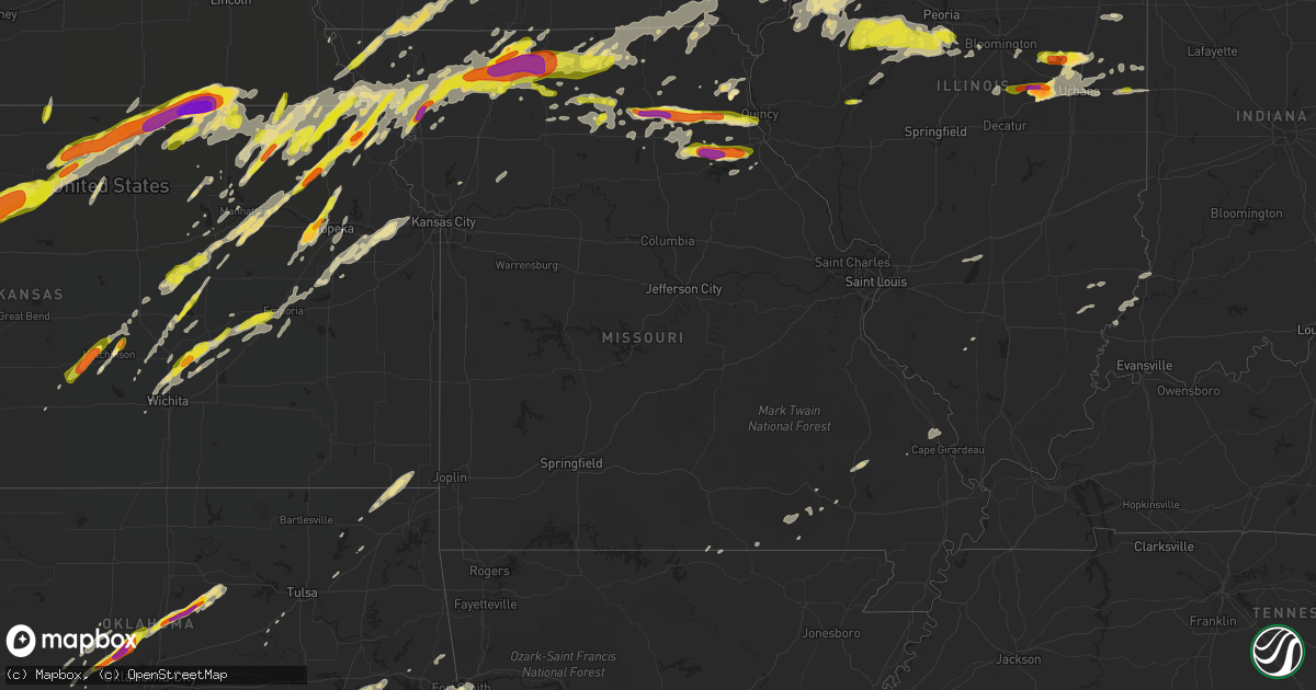
Hail Map in Missouri on May 28, 2019
Get this storm
May 28 map
$229
one time, instant access
Download today. No call, no setup
Keep the $229
Bought the map and want the full workflow? Apply the entire $229 to a subscription within 7 days. None of it is wasted.
Every map, not just this one
This buys you this map. Subscription and you get every map we run, in the markets you choose from a few cities to whole states to nationwide. Plus real-time alerts the moment a storm fires.
Contact data
Name, contact info, occupancy, even credit band for addresses in the footprint. You go from where it hit to who to call.
Become the source they trust
Unlimited branding weather history reports on demand. You already have the documented answer ready for the property owner, and you are the one who showed up with it.
Property data and RoofTrace estimates
Pull up any address you have got, its value and the exact code rules for that jurisdiction, straight from One Click Code. Then RoofTrace estimates the squares, pitch, and roof value, priced the way you price.
Storm reports in Missouri
Missouri
| Date | Description |
|---|---|
| 05/28/20195:45 PM CDT | Broken windows at residences in neighborhood. |
| 05/28/20194:59 PM CDT | A local report indicates 60 MPH wind near 5 S BRIMSON |
| 05/28/20194:45 PM CDT | A local report indicates 1.00 inch wind near COFFEY |
| 05/28/20194:45 PM CDT | Hail stones ranging from quarter to golf ball size. |
| 05/28/20194:42 PM CDT | Hail ranging from quarter to just shy of golf-ball size. Additionally... Strong winds have blown down tree limbs about an inch in diameter. |
| 05/28/20194:40 PM CDT | Several 2 foot diameter trees down. Several windows broken out. Shingle and siding damage. Numerous streets blocked with debris. |
| 05/28/20193:54 PM CDT | Delayed report. |
| 05/28/20193:30 PM CDT | Delayed report. |
| 05/28/20193:26 PM CDT | A local report indicates 1.75 inch wind near 1 E RIDGEWAY |
| 05/28/20193:25 PM CDT | A local report indicates 1.25 inch wind near SAVANNAH |
| 05/28/20193:20 PM CDT | In addition to ping pong ball sized hail... 1.87 inches of rain fell with storms. |
| 05/28/20192:15 PM CDT | A local report indicates 1.75 inch wind near MONROE CITY |
| 05/28/20192:14 PM CDT | A local report indicates 1.00 inch wind near BOLCKOW |
| 05/28/20192:06 PM CDT | A local report indicates 1.00 inch wind near 4 ENE OREGON |
| 05/28/20191:47 PM CDT | A local report indicates 1.00 inch wind near 1 ENE SHELBINA |
| 05/28/20191:33 PM CDT | A local report indicates 1.00 inch wind near 1 S TAYLOR |
| 05/28/20191:26 PM CDT | A local report indicates 1.75 inch wind near BETHEL |
| 05/28/20191:24 PM CDT | Facebook post. |
| 05/28/201912:07 PM CDT | Time estimated from radar. |
| 05/28/201911:45 AM CDT | Radar estimated time. |
| 05/28/201910:06 AM CDT | A local report indicates 1.00 inch wind near 1 SSE TINDALL |
| 05/28/20197:53 AM CDT | At 1253 PM CDT, a severe thunderstorm was located near Plevna, moving east at 30 mph. HAZARD...Two inch hail and 60 mph wind gusts. SOURCE...Radar indicated. IMPACT...People and animals outdoors will be injured. Expect hail damage to roofs, siding, windows, and vehicles. Expect wind damage to roofs, siding, and trees. Locations impacted include... Ewing, Maywood, Philadelphia, Steffenville, Bethel and Newark. |
| 05/28/20197:05 AM CDT | At 1205 PM CDT, severe thunderstorms were located along a line extending from near La Plata to Atlanta to 6 miles northwest of Callao, moving east at 30 mph. HAZARD...Ping pong ball size hail and 60 mph wind gusts. SOURCE...Radar indicated. IMPACT...People and animals outdoors will be injured. Expect hail damage to roofs, siding, windows, and vehicles. Expect wind damage to roofs, siding, and trees. Locations impacted include... La Belle, Shelbyville, Plevna, Steffenville, Novelty, Bethel, Newark and Leonard. |
| 05/28/20196:38 AM CDT | At 1138 AM CDT, severe thunderstorms were located along a line extending from 6 miles south of Novinger to near Bucklin, moving east at 35 mph. HAZARD...60 mph wind gusts and quarter size hail. SOURCE...Radar indicated. IMPACT...Hail damage to vehicles is expected. Expect wind damage to roofs, siding, and trees. Locations impacted include... Kirksville, Macon, Marceline, La Plata, Bevier, Bucklin, Atlanta, Callao, Brashear, New Cambria, Gibbs, Millard, Elmer, Ethel, South Gifford, Kirksville Regional and New Boston. |
| 05/28/20195:58 AM CDT | At 1056 PM CDT, a severe thunderstorm was located 10 miles southwest of Stanberry, moving northeast at 55 mph. HAZARD...60 mph wind gusts and quarter size hail. SOURCE...Radar indicated. IMPACT...Hail damage to vehicles is expected. Expect wind damage to roofs, siding, and trees. Locations impacted include... Albany, Stanberry, Barnard, Conception Junction, Darlington, Guilford, Clyde, Gentry, Worth, Rea, Ford City and Conception. |
| 05/28/20195:56 AM CDT | At 1056 AM CDT, severe thunderstorms were located along a line extending from near Milan to near Wheeling, moving east at 30 mph. HAZARD...60 mph wind gusts and quarter size hail. SOURCE...Radar indicated. IMPACT...Hail damage to vehicles is expected. Expect wind damage to roofs, siding, and trees. Locations impacted include... Brookfield, Marceline, Bucklin, Meadville, Laclede, Linneus, Browning, Purdin, Reger, New Boston, Saint Catherine and Winigan. |
| 05/28/20195:37 AM CDT | At 1036 PM CDT, a severe thunderstorm was located near Fillmore, or 12 miles northwest of Savannah, moving northeast at 50 mph. HAZARD...60 mph wind gusts and quarter size hail. SOURCE...Radar indicated. IMPACT...Hail damage to vehicles is expected. Expect wind damage to roofs, siding, and trees. Locations impacted include... Fillmore, Barnard, Conception Junction, Bolckow, Rosendale, Guilford, Clyde, Rea and Conception.This includes Interstate 29 between mile markers 64 and 67. |
| 05/28/20195:32 AM CDT | At 1031 AM CDT, a severe thunderstorm was located near Galt, or 13 miles east of Trenton, moving east at 35 mph. HAZARD...60 mph wind gusts and quarter size hail. SOURCE...Radar indicated. IMPACT...Hail damage to vehicles is expected. Expect wind damage to roofs, siding, and trees. Locations impacted include... Milan, Browning, Galt, Humphreys, Osgood and Reger. |
| 05/28/20195:30 AM CDT | Fifteen to 20 trees damaged and some light damage to buildings at thayer country club. Report relayed by k-kountry radio. |
| 05/28/20195:05 AM CDT | At 1004 PM CDT, a severe thunderstorm was located over Bedford, moving northeast at 65 mph. HAZARD...Quarter size hail. SOURCE...Radar indicated. IMPACT...Damage to vehicles is expected. Locations impacted include... Creston, Bedford, Lenox, Green Valley Lake, New Market, Clearfield, Diagonal, Prescott, Gravity, Cromwell, Arispe, Sharpsburg, Shannon City, Kent, Conway, Lake Of Three Fires State Park, Creston Municipal Airport, Bedford Municipal Airport and Green Valley Lake State Park. |
| 05/28/20191:53 AM CDT | At 653 PM CDT, severe thunderstorms were located along a line extending from near Olds to near West Point to near New Boston, moving east at 40 mph. HAZARD...60 mph wind gusts and quarter size hail. SOURCE...Radar indicated. IMPACT...Hail damage to vehicles is expected. Expect wind damage to roofs, siding, and trees. Locations impacted include... Burlington, Fort Madison, Monmouth, Mount Pleasant, Aledo, Wapello, Oquawka, Nauvoo, West Burlington, Burgess, New London, Mediapolis, La Harpe, Winfield, Roseville, West Point, Dallas City, Danville, Donnellson and Montrose. |
| 05/28/20191:51 AM CDT | At 651 PM CDT, a severe thunderstorm was located near Tonganoxie, moving northeast at 35 mph. HAZARD...Golf ball size hail and 70 mph wind gusts. SOURCE...Radar indicated. IMPACT...People and animals outdoors will be injured. Expect hail damage to roofs, siding, windows, and vehicles. Expect considerable tree damage. Wind damage is also likely to mobile homes, roofs, and outbuildings. Locations impacted include... Shawnee, Leavenworth, Gladstone, Lansing, Bonner Springs, Parkville, Tonganoxie, Platte City, Basehor, Edwardsville, North Kansas City, Riverside, Weatherby Lake, Kansas City Kansas, Kansas City, Lake Waukomis, Ferrelview, Avondale, Platte Woods and Linwood.This includes the following highways... Interstate 70 in Kansas between mile markers 410 and 419. Interstate 35 in Missouri between mile markers 6 and 10. Interstate 29 between mile markers 0 and 18. Interstate 635 between mile markers 4 and 12. Interstate 435 between mile markers 10 and 38. Kansas Turnpike between mile markers 213 and 226. |
| 05/28/20191:35 AM CDT | At 635 PM CDT, a severe thunderstorm was located near Chetopa, moving northeast at 70 mph. HAZARD...60 mph wind gusts and quarter size hail. SOURCE...Radar indicated. IMPACT...Hail damage to vehicles is expected. Expect wind damage to roofs, siding, and trees. Locations impacted include... Northwestern Joplin... Webb City... Carl Junction... Baxter Springs... Columbus... Galena... Oronogo... Carterville... Jasper... Cherokee... Airport Drive... Weir... Lowell... Alba... Scammon... Purcell... Carytown... Asbury... Neck City... West Mineral...This includes Interstate 49 between mile markers 48 and 55. |
| 05/28/20191:19 AM CDT | At 618 AM CDT, a severe thunderstorm was located over Clarinda, or 14 miles west of Bedford, moving east at 55 mph. HAZARD...60 mph wind gusts and quarter size hail. SOURCE...Radar indicated. IMPACT...Hail damage to vehicles is expected. Expect wind damage to roofs, siding, and trees. Locations impacted include... Mount Ayr, Bedford, Lenox, New Market, Clearfield, Diagonal, Blockton, Gravity, Nodaway, Sharpsburg, Redding, Shannon City, Kent, Conway, Benton, Maloy, Delphos, Athelstan, Lake Of Three Fires State Park and Bedford Municipal Airport. |
| 05/28/201912:53 AM CDT | At 553 AM CDT, a severe thunderstorm was located near Shenandoah, or 21 miles north of Tarkio, moving east at 40 mph. HAZARD...60 mph wind gusts and quarter size hail. SOURCE...Radar indicated. IMPACT...Hail damage to vehicles is expected. Expect wind damage to roofs, siding, and trees. Locations impacted include... Clarinda, Shenandoah, Villisca, Essex, Farragut, Riverton, Coin, Braddyville, College Springs, Shambaugh, Randolph, Yorktown, Imogene, Northboro, Coburg, Blanchard, Hepburn and Pierce Recreation Area. |
| 05/28/201912:29 AM CDT | At 528 AM CDT, a severe thunderstorm was located near Union, or 33 miles south of Omaha, moving east at 40 mph. HAZARD...60 mph wind gusts and quarter size hail. SOURCE...Radar indicated. IMPACT...Hail damage to vehicles is expected. Expect wind damage to roofs, siding, and trees. Locations impacted include... Nebraska City, Hamburg, Sidney, Farragut, Murray, Riverton, Union, Nehawka, Tabor, Thurman, Randolph, Imogene, Camp Catron and Waubonsie State Park.This includes Interstate 29 between mile markers 1 and 25. |
| 05/27/201911:54 PM CDT | At 454 PM CDT, a severe thunderstorm was located near Ridgeway, or 9 miles northeast of Bethany, moving northeast at 55 mph. HAZARD...Golf ball size hail and 60 mph wind gusts. SOURCE...Radar indicated. IMPACT...People and animals outdoors will be injured. Expect hail damage to roofs, siding, windows, and vehicles. Expect wind damage to roofs, siding, and trees. Locations impacted include... Princeton, Ridgeway, Mercer, Cainsville, Mount Moriah and South Lineville. |
| 05/27/201911:53 PM CDT | At 453 PM CDT, a severe thunderstorm was located over Gilman City, or 10 miles southeast of Bethany, moving northeast at 55 mph. HAZARD...Golf ball size hail and 60 mph wind gusts. SOURCE...Radar indicated. IMPACT...People and animals outdoors will be injured. Expect hail damage to roofs, siding, windows, and vehicles. Expect wind damage to roofs, siding, and trees. Locations impacted include... Princeton, Gilman City, Spickard, Tindall, Brimson, Modena and Mill Grove.This includes Interstate 35 in Missouri between mile markers 86 and89. |
| 05/27/201911:32 PM CDT | At 432 PM CDT, a severe thunderstorm was located 8 miles southeast of Bloomfield, moving northeast at 35 mph. HAZARD...60 mph wind gusts and quarter size hail. SOURCE...Radar indicated. IMPACT...Hail damage to vehicles is expected. Expect wind damage to roofs, siding, and trees. Locations impacted include... Fairfield, Keosauqua, Batavia, Birmingham, Milton, Bonaparte, Libertyville, Stockport, Lockridge, Maharishi Vedic City, Cantril, Packwood, Pleasant Plain, Douds, Abingdon, Bentonsport/Vernon, Leando, Farmington, Mount Sterling and Glasgow. |
| 05/27/201911:30 PM CDT | At 429 PM CDT, a severe thunderstorm was located near Pattonsburg, or 11 miles southwest of Bethany, moving east at 40 mph. HAZARD...Ping pong ball size hail and 60 mph wind gusts. SOURCE...Radar indicated. IMPACT...People and animals outdoors will be injured. Expect hail damage to roofs, siding, windows, and vehicles. Expect wind damage to roofs, siding, and trees. Locations impacted include... Gilman City, Pattonsburg, Coffey and Mcfall. This includes Interstate 35 in Missouri between mile markers 76 and89. |
| 05/27/201910:55 PM CDT | At 355 PM CDT, a severe thunderstorm was located over Cainsville, or 17 miles northeast of Bethany, moving northeast at 35 mph. HAZARD...Ping pong ball size hail. SOURCE...Radar indicated. IMPACT...People and animals outdoors will be injured. Expect damage to roofs, siding, windows, and vehicles. Locations impacted include... Mercer, Cainsville, Blythedale, Pleasanton and South Lineville. |
| 05/27/201910:28 PM CDT | At 328 PM CDT, severe thunderstorms were located along a line extending from Maitland to near Fillmore to 6 miles southwest of Union Star, moving northeast at 60 mph. HAZARD...60 mph wind gusts and quarter size hail. SOURCE...Radar indicated. IMPACT...Hail damage to vehicles is expected. Expect wind damage to roofs, siding, and trees. Locations impacted include... Maryville, Savannah, Albany, Stanberry, King City, Grant City, Ravenwood, Union Star, Maitland, Fillmore, Irena, Barnard, Conception Junction, Sheridan, Parnell, Bolckow, Graham, Pickering, Rosendale and Darlington. |
| 05/27/201910:11 PM CDT | At 311 PM CDT, a severe thunderstorm was located near Bethany, moving northeast at 45 mph. HAZARD...60 mph wind gusts and quarter size hail. SOURCE...Radar indicated. IMPACT...Hail damage to vehicles is expected. Expect wind damage to roofs, siding, and trees. Locations impacted include... Bethany, Princeton, Ridgeway, Mercer, Eagleville, New Hampton, Cainsville, Blythedale, Mount Moriah, Pleasanton, Martinsville and Modena.This includes Interstate 35 in Missouri between mile markers 89 and112. |
| 05/27/20199:58 PM CDT | At 256 PM CDT, a severe thunderstorm was located over Hamlin, or 8 miles east of Sabetha, moving northeast at 50 mph. HAZARD...Half dollar size hail. SOURCE...Radar Indicated. This storm also has a history of producing quarter size hail in Kansas. IMPACT...Damage to vehicles is expected. Locations impacted include... Falls City, Rulo, Salem, Preston and Barada. |
| 05/27/20199:45 PM CDT | At 245 PM CDT, a severe thunderstorm was located over Stanberry, moving northeast at 60 mph. HAZARD...60 mph wind gusts and quarter size hail. SOURCE...Radar indicated. IMPACT...Hail damage to vehicles is expected. Expect wind damage to roofs, siding, and trees. Locations impacted include... Bethany, Albany, Stanberry, New Hampton, Darlington, Gentry, Worth, Allendale, Denver, Ford City and Martinsville.This includes Interstate 35 in Missouri between mile markers 89 and91. |
| 05/27/20199:03 PM CDT | At 203 PM CDT, a severe thunderstorm was located over Fillmore, or 9 miles northwest of Savannah, moving northeast at 55 mph. HAZARD...60 mph wind gusts and quarter size hail. SOURCE...Radar indicated. IMPACT...Hail damage to vehicles is expected. Expect wind damage to roofs, siding, and trees. Locations impacted include... Maryville, Stanberry, Ravenwood, Barnard, Conception Junction, Bolckow, Graham, Rosendale, Guilford, Clyde, Arkoe, Rea and Conception. |
| 05/27/20198:40 PM CDT | At 140 PM CDT, severe thunderstorms were located along a line extending from near Shelbina to near Woodlawn, moving east at 30 mph. HAZARD...60 mph wind gusts and quarter size hail. SOURCE...Radar indicated. IMPACT...Hail damage to vehicles is expected. Expect wind damage to roofs, siding, and trees. Locations impacted include... Monroe City, Shelbina, Warren, Granville, Emden, Hunnewell, Stoutsville and Indian Creek. |
| 05/27/20198:22 PM CDT | At 121 AM CDT, a severe thunderstorm was located near Tecumseh, or 27 miles east of Beatrice, moving east at 50 mph. HAZARD...Golf ball size hail and 60 mph wind gusts. SOURCE...Radar indicated. IMPACT...People and animals outdoors will be injured. Expect hail damage to roofs, siding, windows, and vehicles. Expect wind damage to roofs, siding, and trees. Locations impacted include... Auburn, Tecumseh, Peru, Sterling, Johnson, Cook, Talmage, Nemaha, Brownville, Brock, Elk Creek, Julian, 7 Miles South Of Auburn, Brownville State Recreation Area and 8 Miles South Of Johnson. |
| 05/27/20198:10 PM CDT | Significant tree damage along highway 92 near ra with trees 8 to 12 inches in diameter uprooted. Damage to shutters and minor roof damage to houses as well as to outbui |
| 05/27/20198:10 PM CDT | Nws storm damage survey team confirmed an ef-2 tornado... With maximum winds of 115 mph and a maximum width of 400 yards... Occurred tuesday evening; beginning 2 to 3 m |
| 05/27/20198:10 PM CDT | Major house damage. Additionally... Roadways are blocked by downed trees and power lines. |
| 05/27/20198:09 PM CDT | Dangerous tornado observed by off-duty nws meteorologist east of kearney. |
| 05/27/20198:06 PM CDT | Tornado confirmed east of kearney. |
All States Impacted by Hail Map on May 28, 2019
Cities Impacted by Hail Map on May 28, 2019
- Big Spring, TX
- Lancaster, PA
- Linden, PA
- Jersey Shore, PA
- Williamsport, PA
- Dalton, PA
- Enon Valley, PA
- Garwood, NJ
- Staten Island, NY
- Roselle, NJ
- Clark, NJ
- Linden, NJ
- Westfield, NJ
- Rahway, NJ
- Cranford, NJ
- Carteret, NJ
- Mountainside, NJ
- Hutchinson, KS
- Abbyville, KS
- Partridge, KS
- Nickerson, KS
- Columbus, KS
- Chetopa, KS
- Miami, OK
- Welch, OK
- Manchester Township, NJ
- Atlanta, MO
- Peru, NE
- Julian, NE
- Nebraska City, NE
- Brock, NE
- Fremont, MO
- Alton, MO
- Doniphan, MO
- Iowa Park, TX
- Randlett, OK
- Duncan, OK
- Foster, OK
- Konawa, OK
- Sasakwa, OK
- Tussy, OK
- Temple, OK
- Allen, OK
- Comanche, OK
- Devol, OK
- Burkburnett, TX
- Grandfield, OK
- Walters, OK
- Wynnewood, OK
- Pauls Valley, OK
- Ada, OK
- Hennepin, OK
- Elmore City, OK
- Holdenville, OK
- Davis, OK
- Marlow, OK
- Stratford, OK
- Tingley, IA
- Diagonal, IA
- Mount Ayr, IA
- Bairdford, PA
- Saxonburg, PA
- Tarentum, PA
- Mars, PA
- Cranberry Township, PA
- Warrendale, PA
- Glenshaw, PA
- Beaver Falls, PA
- Evans City, PA
- Gibsonia, PA
- Sewickley, PA
- Bakerstown, PA
- Baden, PA
- Zelienople, PA
- Russellton, PA
- Renfrew, PA
- Rochester, PA
- Cheswick, PA
- Callery, PA
- Freedom, PA
- Wexford, PA
- New Brighton, PA
- Allison Park, PA
- Valencia, PA
- Butler, PA
- Pittsburgh, PA
- East Freedom, PA
- New Enterprise, PA
- Claysburg, PA
- Portage, PA
- Duncansville, PA
- Roaring Spring, PA
- Sproul, PA
- Imler, PA
- Martinsburg, PA
- White Heath, IL
- Mansfield, IL
- Cisco, IL
- Weldon, IL
- Mahomet, IL
- Seymour, IL
- De Land, IL
- Monticello, IL
- Clubb, MO
- Silva, MO
- Greenville, MO
- Reinholds, PA
- Womelsdorf, PA
- Elverson, PA
- Wernersville, PA
- Richland, PA
- Mohnton, PA
- Morgantown, PA
- Narvon, PA
- Glenmoore, PA
- Robesonia, PA
- Birdsboro, PA
- Bernville, PA
- Reading, PA
- Ellis, KS
- Wakeeney, KS
- Ogallah, KS
- Collyer, KS
- Rush Springs, OK
- Roscoe, TX
- Sweetwater, TX
- Loraine, TX
- Scandia, KS
- Belleville, KS
- Wapakoneta, OH
- Huntsville, OH
- Belle Center, OH
- Lakeview, OH
- Jackson, MO
- Wellsville, OH
- East Liverpool, OH
- Van Wert, IA
- Grand River, IA
- Exton, PA
- Downingtown, PA
- Benton, KS
- Burns, KS
- Whitewater, KS
- Potwin, KS
- Mehoopany, PA
- Tunkhannock, PA
- Olyphant, PA
- Factoryville, PA
- Scranton, PA
- Clarks Summit, PA
- Laceyville, PA
- Moscow, PA
- Lake Ariel, PA
- Falls, PA
- Meshoppen, PA
- Belvue, KS
- Chatsworth, NJ
- North East, MD
- Charlestown, MD
- Perryville, MD
- Elkton, MD
- Manhattan, KS
- Rotan, TX
- New Galilee, PA
- Du Bois, NE
- Hiawatha, KS
- Blue Rapids, KS
- Goff, KS
- Craig, MO
- Guilford, MO
- Sabetha, KS
- Vermillion, KS
- Axtell, KS
- Amazonia, MO
- Soldier, KS
- Morrill, KS
- Olsburg, KS
- Holton, KS
- Forest City, MO
- Robinson, KS
- Fairview, KS
- Savannah, MO
- Netawaka, KS
- Rulo, NE
- Fillmore, MO
- Oneida, KS
- White Cloud, KS
- Barnard, MO
- Baileyville, KS
- Maitland, MO
- Oregon, MO
- Frankfort, KS
- Horton, KS
- Westmoreland, KS
- Falls City, NE
- Humboldt, NE
- Emmett, KS
- Bolckow, MO
- Bern, KS
- Mound City, MO
- Highland, KS
- Rosendale, MO
- Wetmore, KS
- Delia, KS
- Whiting, KS
- Centralia, KS
- Circleville, KS
- Seneca, KS
- Everest, KS
- Corning, KS
- Dawson, NE
- Latrobe, PA
- Leetsdale, PA
- Cabot, PA
- Hinckley, OH
- New Florence, PA
- Berlin Center, OH
- Greensburg, PA
- Sarver, PA
- Ebensburg, PA
- Cowansville, PA
- Monaca, PA
- Kent, OH
- Akron, OH
- Indiana, PA
- Gallitzin, PA
- Darlington, PA
- McIntyre, PA
- Creighton, PA
- Diamond, OH
- Homer City, PA
- Brush Valley, PA
- Wampum, PA
- Beloit, OH
- Woodbury, PA
- Blairsville, PA
- Spring Church, PA
- Johnstown, PA
- McGrann, PA
- Nanty Glo, PA
- Rootstown, OH
- North Benton, OH
- Hartville, OH
- South Heights, PA
- Yatesboro, PA
- Shelocta, PA
- Delmont, PA
- Portersville, PA
- Ashville, PA
- Barberton, OH
- North Apollo, PA
- Vintondale, PA
- Louisville, OH
- Aultman, PA
- Ravenna, OH
- Oakmont, PA
- Crescent, PA
- Canfield, OH
- Salineville, OH
- Saxton, PA
- McKees Rocks, PA
- Marion Center, PA
- Washingtonville, OH
- Sebring, OH
- Chicora, PA
- North Jackson, OH
- Youngstown, OH
- Medina, OH
- New Springfield, OH
- Apollo, PA
- Ford Cliff, PA
- Sidman, PA
- Clinton, PA
- Avonmore, PA
- Munroe Falls, OH
- Freeport, PA
- Rogers, OH
- Export, PA
- Uniontown, OH
- Fenelton, PA
- James Creek, PA
- Negley, OH
- Bridgeville, PA
- West Lebanon, PA
- Coraopolis, PA
- Beaver, PA
- Lakemore, OH
- Harmony, PA
- Deerfield, OH
- West Mifflin, PA
- Newry, PA
- Indianola, PA
- Coral, PA
- Josephine, PA
- Saltsburg, PA
- Ellwood City, PA
- Fombell, PA
- Leetonia, OH
- Rural Valley, PA
- Midland, PA
- Starford, PA
- Lisbon, OH
- Cuyahoga Falls, OH
- New Waterford, OH
- Springdale, PA
- Pulaski, PA
- Carnegie, PA
- Edinburg, PA
- Limaville, OH
- Natrona Heights, PA
- Vandergrift, PA
- Slippery Rock, PA
- Commodore, PA
- New Kensington, PA
- Bradfordwoods, PA
- Heilwood, PA
- East Palestine, OH
- Hanoverton, OH
- Slickville, PA
- Williamsburg, PA
- Damascus, OH
- Brackenridge, PA
- Home, PA
- Connoquenessing, PA
- Tallmadge, OH
- Ambridge, PA
- Black Lick, PA
- Clymer, PA
- Lyndora, PA
- Koppel, PA
- Mineral Point, PA
- East Butler, PA
- Presto, PA
- New Alexandria, PA
- Conway, PA
- Twin Rocks, PA
- Petersburg, OH
- New Derry, PA
- Summerhill, PA
- Harwick, PA
- Industry, PA
- North Canton, OH
- New Castle, PA
- Penn Run, PA
- Seward, PA
- East Rochester, OH
- Ford City, PA
- Northern Cambria, PA
- Braddock, PA
- Hillsville, PA
- Campbell, OH
- Carrolltown, PA
- Clarksburg, PA
- Leechburg, PA
- North Lima, OH
- Lake Milton, OH
- Columbiana, OH
- Loretto, PA
- Derry, PA
- Salem, OH
- Bessemer, PA
- Elderton, PA
- Manorville, PA
- Clune, PA
- Mogadore, OH
- Homestead, PA
- Worthington, PA
- Brunswick, OH
- Prospect, PA
- Colver, PA
- Canton, OH
- Belsano, PA
- Aliquippa, PA
- Oakdale, PA
- Hollidaysburg, PA
- Cresson, PA
- Dilltown, PA
- Alliance, OH
- Struthers, OH
- Lucernemines, PA
- Kittanning, PA
- Valley City, OH
- Ernest, PA
- Atwater, OH
- Creekside, PA
- Crabtree, PA
- Dixonville, PA
- Verona, PA
- Murrysville, PA
- South Fork, PA
- Lilly, PA
- Lowellville, OH
- Nicktown, PA
- Sagamore, PA
- Adrian, PA
- Mentcle, PA
- Armagh, PA
- Strongstown, PA
- Pawnee City, NE
- Yukon, OK
- Edmond, OK
- Cashion, OK
- El Reno, OK
- Okarche, OK
- Piedmont, OK
- Berwick, IL
- Kirkwood, IL
- Roseville, IL
- Cameron, IL
- Smithshire, IL
- Stronghurst, IL
- Raritan, IL
- Biggsville, IL
- Media, IL
- Monmouth, IL
- Clarion, PA
- Sligo, PA
- Perkins, OK
- Stillwater, OK
- Toms River, NJ
- Alexandria, PA
- Altoona, PA
- Tyrone, PA
- Atoka, OK
- Coleman, OK
- Kenefic, OK
- Green City, MO
- Unionville, MO
- Murray, IA
- Steele City, NE
- Mahaska, KS
- Esbon, KS
- Randall, KS
- Waldo, KS
- Paradise, KS
- Formoso, KS
- Plainville, KS
- Marysville, KS
- Luray, KS
- Beloit, KS
- Morrowville, KS
- Odell, NE
- Courtland, KS
- Fairbury, NE
- Bremen, KS
- Haddam, KS
- Jewell, KS
- Beatrice, NE
- Natoma, KS
- Cawker City, KS
- Glen Elder, KS
- Diller, NE
- Linn, KS
- Clifton, KS
- Osborne, KS
- Alton, KS
- Cuba, KS
- Endicott, NE
- Blue Springs, NE
- Mankato, KS
- Narka, KS
- Norway, KS
- Tipton, KS
- Washington, KS
- Munden, KS
- Downs, KS
- Hanover, KS
- Hollenberg, KS
- Wymore, NE
- Geneva, IN
- Stanton, TX
- Fisher, IL
- Gibson City, IL
- Dewey, IL
- Thomasboro, IL
- Ludlow, IL
- Champaign, IL
- Paxton, IL
- Rantoul, IL
- Valley Center, KS
- Sandy Lake, PA
- Lickingville, PA
- Cooksburg, PA
- Clarington, PA
- Tionesta, PA
- Fryburg, PA
- Vowinckel, PA
- Lucinda, PA
- Sigel, PA
- Venus, PA
- Leeper, PA
- Strattanville, PA
- Brookville, PA
- Ringtown, PA
- Shenandoah, PA
- Catawissa, PA
- Elysburg, PA
- Wilburton, PA
- Brashear, MO
- Hurdland, MO
- Baring, MO
- Mifflinburg, PA
- Stoneboro, PA
- Polk, PA
- Fredonia, PA
- Clarks Mills, PA
- Cheyenne Wells, CO
- Pinckneyville, IL
- Lomax, IL
- Scott City, KS
- Saint Georges, DE
- New Castle, DE
- Delaware City, DE
- Salem, NJ
- Middletown, DE
- Bear, DE
- Newark, DE
- Hope, KS
- Arapahoe, CO
- Newton, KS
- Mill Creek, PA
- Huntingdon, PA
- Orbisonia, PA
- McVeytown, PA
- Oakley, KS
- Tonganoxie, KS
- Linwood, KS
- Lawrence, KS
- Pleasantville, PA
- Kokomo, IN
- Manahawkin, NJ
- Barnegat, NJ
- Waynesfield, OH
- Lima, OH
- Uniopolis, OH
- Coyle, OK
- Bloomfield, IA
- Bendena, KS
- Troy, KS
- Overbrook, KS
- Carbondale, KS
- Scranton, KS
- Berryton, KS
- Alma, KS
- Topeka, KS
- Sugar Run, PA
- Wyalusing, PA
- New Albany, PA
- Nottingham, PA
- Peach Bottom, PA
- New London, MO
- Center, MO
- Mcalester, OK
- Indiahoma, OK
- Wallace, KS
- Cottonwood Falls, KS
- Braddyville, IA
- North Bend, PA
- Lock Haven, PA
- Lawton, OK
- Flinton, PA
- Fallentimber, PA
- La Harpe, IL
- Albia, IA
- Dallas City, IL
- Osceola, IA
- Keosauqua, IA
- Continental, OH
- Miller City, OH
- Ottawa, OH
- Leipsic, OH
- Calverton, NY
- Purcell, OK
- Montandon, PA
- Lewisburg, PA
- Milton, PA
- Elizabeth, NJ
- Newark, NJ
- Quinter, KS
- Maple Hill, KS
- Russell, IA
- Chariton, IA
- Pulaski, IA
- Guthrie, OK
- Osage City, KS
- Lyndon, KS
- Midland, TX
- Parker, PA
- Harrisville, PA
- Boyers, PA
- Petrolia, PA
- Hilliards, PA
- West Burlington, IA
- Burlington, IA
- Sperry, IA
- Pennsville, NJ
- Templeton, PA
- Westover, PA
- Coalport, PA
- Hastings, PA
- Glen Campbell, PA
- Patton, PA
- La Jose, PA
- Cherry Tree, PA
- Concordia, KS
- Jamestown, KS
- Sharon Springs, KS
- Penns Grove, NJ
- Wilmington, DE
- Alloway, NJ
- Shiloh, NJ
- Woodstown, NJ
- Bridgeton, NJ
- Speer, IL
- Gracemont, OK
- Brookfield, MO
- Blythedale, MO
- Ridgeway, MO
- Cainsville, MO
- Richmond, MO
- Rayville, MO
- Polo, MO
- Cowgill, MO
- Whitefield, OK
- Stigler, OK
- Oakwood, OH
- Mercer, PA
- Grove City, PA
- Bruin, PA
- West Sunbury, PA
- Remsenburg, NY
- Speonk, NY
- Paris, MO
- Shelbina, MO
- Memphis, MO
- Arbela, MO
- Morris Plains, NJ
- Hammonton, NJ
- Cantril, IA
- Leonard, MO
- Shelbyville, MO
- Bethel, MO
- Weldon, IA
- Cutler, IN
- Bringhurst, IN
- Rossville, IN
- Browning, IL
- Havana, IL
- Astoria, IL
- Burr Oak, KS
- Red Cloud, NE
- Lebanon, KS
- Strasburg, PA
- Manheim, PA
- Gordonville, PA
- Smoketown, PA
- Ronks, PA
- Bird In Hand, PA
- Paradise, PA
- East Petersburg, PA
- Lititz, PA
- Fletcher, OK
- East Stroudsburg, PA
- Blairstown, NJ
- Columbia, NJ
- Catlin, IL
- Tilton, IL
- Oakwood, IL
- Fithian, IL
- Covington, IN
- Fairmount, IL
- Danville, IL
- Harrod, OH
- Havensville, KS
- Dwight, KS
- Alta Vista, KS
- Wamego, KS
- Junction City, KS
- Saint Marys, KS
- Clearfield, IA
- Argenta, IL
- Novelty, MO
- La Plata, MO
- Eufaula, OK
- Berne, IN
- Rockford, OH
- Bryant, IN
- Celina, OH
- Keystone, IN
- Coldwater, OH
- Tecumseh, NE
- Cook, NE
- Steinauer, NE
- Elk Creek, NE
- Imboden, AR
- Sheppard Afb, TX
- Wichita Falls, TX
- Rockton, PA
- Cassville, PA
- Mapleton Depot, PA
- Cache, OK
- Fort Sill, OK
- Honey Brook, PA
- Hinton, OK
- Darlington, MO
- Albany, MO
- McFall, MO
- Gilman City, MO
- Rea, MO
- Stanberry, MO
- Princeton, MO
- King City, MO
- Eagleville, MO
- Union Star, MO
- Bethany, MO
- New Hampton, MO
- Kermit, TX
- Cross Fork, PA
- Monroe, CT
- Ansonia, CT
- Orange, CT
- Woodbridge, CT
- Shelton, CT
- New Haven, CT
- Derby, CT
- Newtown, CT
- West Haven, CT
- Keansburg, NJ
- Calvin, OK
- Clay Center, KS
- Knox, PA
- Shamokin, PA
- Klingerstown, PA
- Leck Kill, PA
- Dornsife, PA
- Selinsgrove, PA
- Paxinos, PA
- Middleburg, PA
- Winfield, PA
- Sunbury, PA
- Trevorton, PA
- Shamokin Dam, PA
- Rebuck, PA
- Goldsmith, TX
- Ripley, OK
- Monticello, MO
- Lewistown, MO
- Weskan, KS
- Stevensville, PA
- Monroeville, IN
- Woodburn, IN
- New Haven, IN
- Fort Wayne, IN
- Coahoma, TX
- Glencoe, OK
- Yale, OK
- Roby, TX
- Sylvester, TX
- Arriba, CO
- Emporia, KS
- Mccurtain, OK
- Bokoshe, OK
- Sheffield, PA
- Knoxville, IL
- Gilson, IL
- Glen Mills, PA
- Garnet Valley, PA
- Chadds Ford, PA
- Hermitage, PA
- Westboro, MO
- Tarkio, MO
- Gravity, IA
- New Market, IA
- Bedford, IA
- Blanchard, IA
- Shannon City, IA
- Shubert, NE
- Clarinda, IA
- Nemaha, NE
- Hopkins, MO
- Sharpsburg, IA
- Lenox, IA
- Clearmont, MO
- Elmo, MO
- Rock Port, MO
- Fairfax, MO
- Convoy, OH
- Oley, PA
- Douglassville, PA
- Gibbs, MO
- Fort Riley, KS
- Riley, KS
- McCaulley, TX
- Trent, TX
- Westbrook, TX
- Colorado City, TX
- Lincolnville, KS
- Lost Springs, KS
- Landisville, PA
- Leola, PA
- Parkesburg, PA
- Cochranville, PA
- Christiana, PA
- Atglen, PA
- Quarryville, PA
- Elgin, OK
- Green Valley, IL
- Pekin, IL
- Lawrenceville, IL
- Vincennes, IN
- Apache, OK
- Urbana, IN
- Andrews, IN
- Lenorah, TX
- Knott, TX
- Kellyville, OK
- Milford, IL
- Onarga, IL
- Ritzville, WA
- Sewell, NJ
- Lovilia, IA
- Yarmouth, IA
- Middletown, IA
- Danville, IA
- New London, IA
- Barstow, TX
- Monahans, TX
- Pyote, TX
- Mill Hall, PA
- Chelsea, OK
- Tremont, IL
- Fowler, IN
- Claymont, DE
- Pedricktown, NJ
- Swedesboro, NJ
- Pollock, MO
- Milan, MO
- Muldrow, OK
- Sallisaw, OK
- Holliday, TX
- Byers, TX
- Petrolia, TX
- Electra, TX
- Cammal, PA
- Manito, IL
- Canton, IL
- Glasford, IL
- Beattie, KS
- Home, KS
- Maywood, MO
- Ewing, MO
- Palmyra, MO
- Philadelphia, MO
- Emden, MO
- Taylor, MO
- Andrews, TX
- Gardendale, TX
- Odessa, TX
- La Belle, MO
- Madison, MO
- Anabel, MO
- Holliday, MO
- Hannibal, MO
- Lentner, MO
- Hunnewell, MO
- Stoutsville, MO
- Clarence, MO
- Monroe City, MO
- Olpe, KS
- Madison, KS
- Hartford, KS
- Wildwood, NJ
- Cape May Court House, NJ
- Haddonfield, NJ
- Cherry Hill, NJ
- Decker, IN
- Mount Carmel, IL
- New Columbia, PA
- Loganton, PA
- Saint Marys, OH
- Kelleys Island, OH
- Rehrersburg, PA
- Maryville, MO
- Fredericksburg, OH
- Millersburg, OH
- Shoals, IN
- New Cambria, MO
- Callao, MO
- Mcpherson, KS
- Denton, KS
- Shreve, OH
- Bradley, OK
- Lindsay, OK
- Clinton, AR
- Leslie, AR
- Lagro, IN
- Huntington, IN
- Elbing, KS
- Arcadia, PA
- Blandburg, PA
- Hillsdale, PA
- Delavan, IL
- Hopedale, IL
- Ethel, MO
- Ramona, KS
- Marion, KS
- Good Hope, IL
- Sciota, IL
- Jackson Center, PA
- Kennerdell, PA
- Marienville, PA
- Montgomery, IN
- Pitman, PA
- New Berlin, PA
- Hegins, PA
- Chesapeake City, MD
- Strong City, KS
- Milton, IA
- Leon, IA
- Woodburn, IA
- Blackwood, NJ
- Mantua, NJ
- Cedar Point, KS
- Morris, PA
- Cedar Run, PA
- Forked River, NJ
- Cunningham, KS
- Pratt, KS
- Saint Paul, AR
- Combs, AR
- Hill City, KS
- Park, KS
- Halstead, KS
- Chillicothe, MO
- Chula, MO
- Loveland, OK
- Chattanooga, OK
- Utica, PA
- Lorain, OH
- Mount Union, IA
- Mount Pleasant, IA
- Goldsmith, IN
- Tipton, IN
- Frankfort, IN
- Russiaville, IN
- Coffey, MO
- Bayville, NJ
- Lanoka Harbor, NJ
- Faxon, OK
- Marietta, IL
- Pocola, OK
- Spiro, OK
- Fort Smith, AR
- Arkoma, OK
- Simpson, KS
- Asher, OK
- Leesburg, NJ
- Newport, NJ
- Cedarville, NJ
- Port Norris, NJ
- Heislerville, NJ
- Millville, NJ
- Delmont, NJ
- Tamiment, PA
- Bushkill, PA
- Hillsboro, IN
- Grandin, MO
- Austin, PA
- Waterville, PA
- Allenwood, PA
- Montgomery, PA
- Renovo, PA
- Winigan, MO
- Browning, MO
- Green Castle, MO
- Linneus, MO
- New Boston, MO
- Bucklin, MO
- Purdin, MO
- Humphreys, MO
- Denison, KS
- Auburn, KS
- Harveyville, KS
- Silver Lake, KS
- Hoyt, KS
- Mayetta, KS
- Sedgwick, KS
- Peabody, KS
- Florence, KS
- Melrose, IA
- Monroeville, PA
- Henryville, PA
- Cannelburg, IN
- Loogootee, IN
- Stow, OH
- Peninsula, OH
- Hudson, OH
- Bowling Green, OH
- Palco, KS
- Elmdale, KS
- Nicholson, PA
- Springville, PA
- Vincentown, NJ
- Pine Grove, PA
- Tremont, PA
- Valley View, PA
- Elmwood, IL
- Williamsfield, IL
- Smithville, AR
- Black Rock, AR
- Spickard, MO
- Northumberland, PA
- Franklin, PA
- Wathena, KS
- Saint Joseph, MO
- Kenilworth, NJ
- Springfield, NJ
- Scotch Plains, NJ
- Roselle Park, NJ
- Colonia, NJ
- Kennett Square, PA
- Cassoday, KS
- Wabash, IN
- Stanhope, NJ
- Andover, NJ
- Quinton, OK
- Porum, OK
- Checotah, OK
- Quogue, NY
- Westhampton Beach, NY
- Rochester Mills, PA
- Pickering, MO
- Inman, KS
- Red Oak, IA
- Stanton, IA
- Essex, IA
- Gepp, AR
- Frederick, OK
- Hollister, OK
- Thayer, IA
- Ellston, IA
- Gypsum, KS
- Ninnekah, OK
- Tarzan, TX
- Canton, PA
- Eastport, NY
- Westhampton, NY
- Indianola, OK
- Crowder, OK
- Webbers Falls, OK
- Canadian, OK
- Hermleigh, TX
- Snyder, TX
- Laurelton, PA
- Sacramento, PA
- Rebersburg, PA
- Millmont, PA
- Muir, PA
- Tower City, PA
- Skidmore, MO
- Burlington Junction, MO
- Filley, NE
- Intercourse, PA
- Washington Boro, PA
- Gap, PA
- Elizabethtown, PA
- Mountville, PA
- Wrightsville, PA
- Kinzers, PA
- York, PA
- West Grove, PA
- Mount Joy, PA
- Columbia, PA
- Coatesville, PA
- Winona, KS
- Macomb, IL
- Herington, KS
- Liberty, NE
- Abilene, KS
- Burchard, NE
- Onaga, KS
- Clyde, KS
- Lancaster, MO
- Kirksville, MO
- Douds, IA
- Enterprise, KS
- Gorham, KS
- Durham, KS
- Waterville, KS
- Lucerne, MO
- Martinsville, MO
- Conception Junction, MO
- Trenton, MO
- Victoria, KS
- Novinger, MO
- Harris, MO
- Bonaparte, IA
- Stockport, IA
- Graham, MO
- Luray, MO
- Galt, MO
- Stockton, KS
- Livonia, MO
- Denver, MO
- Catharine, KS
- Helena, MO
- Verdon, NE
- Conception, MO
- Greenleaf, KS
- Oketo, KS
- Saint George, KS
- Mount Sterling, IA
- Exline, IA
- Moulton, IA
- Barnes, KS
- Newtown, MO
- Glenwood, MO
- Salem, NE
- Birmingham, IA
- Woodbine, KS
- Chapman, KS
- Downing, MO
- Worthington, MO
- Coatsville, MO
- Gentry, MO
- Agenda, KS
- Pattonsburg, MO
- Greentop, MO
- Farmington, IA
- Tampa, KS
- Pawnee, OK
- Maramec, OK
- Calumet, OK
- Maize, KS
- Admire, KS
- Kechi, KS
- Wichita, KS
- Matfield Green, KS
- Reading, KS
- Vinita, OK
- Bluejacket, OK
- Lakehurst, NJ
- Danville, PA
- Beech Creek, PA
- Herndon, PA
- West Milton, PA
- Beach City, OH
- Dundee, OH
- Wilmot, OH
- Saybrook, IL
- Penfield, IL
- Saint Joseph, IL
- Ogden, IL
- Foosland, IL
- Urbana, IL
- Bondville, IL
- Arrowsmith, IL
- Bellflower, IL
- Columbus Grove, OH
- Cogan Station, PA
- Afton, IA
- Twinsburg, OH
- Miller Place, NY
- Middle Island, NY
- Ashwood, OR
- Poplar Bluff, MO
- Ellsinore, MO
- Bristow, OK
- Decatur, IN
- Grinnell, KS
- Grainfield, KS
- Gove, KS
- East Hanover, NJ
- Wharton, NJ
- Kenvil, NJ
- Whippany, NJ
- Randolph, NJ
- Dover, NJ
- Parsippany, NJ
- Denville, NJ
- Cedar Knolls, NJ
- La Fontaine, IN
- Leopold, MO
- West Middlesex, PA
- Bayonne, NJ
- Jersey City, NJ
- Ottumwa, IA
- Unionville, IA
- Moravia, IA
- Blakesburg, IA
- Kellerton, IA
- Dravosburg, PA
- Greenock, PA
- Clairton, PA
- Mckeesport, PA
- Elizabeth, PA
- Duquesne, PA
- Glassport, PA
- Irwin, PA
- Geary, OK
- Brockway, PA
- Alex, OK
- Lexington, OK
- Noble, OK
- Maysville, OK
- Byars, OK
- New Virginia, IA
- Abingdon, IL
- Saint Augustine, IL
- Higden, AR
- Drasco, AR
- Heber Springs, AR
- Buhler, KS
- Smithfield, IL
- Cuba, IL
- Lewistown, IL
- London Mills, IL
- Saint David, IL
- Topeka, IL
- Table Grove, IL
- South Pekin, IL
- Norris, IL
- Avon, IL
- Farmington, IL
- Bryant, IL
- Fairview, IL
- Groveland, IL
- Ellisville, IL
- Prosser, WA
- Benton City, WA
- Ellensburg, WA
- Kingfisher, OK
- Elmer, MO
- Newark, MO
- Marion, IN
- Watsontown, PA
- Short Hills, NJ
- Maplewood, NJ
- Landing, NJ
- Morristown, NJ
- Irvington, NJ
- Livingston, NJ
- West Orange, NJ
- Hopatcong, NJ
- Florham Park, NJ
- Millburn, NJ
- Mine Hill, NJ
- Rockaway, NJ
- Mount Tabor, NJ
- Mount Arlington, NJ
- South Orange, NJ
- Bethel, PA
- Myerstown, PA
- Bolivar, PA
- Salem, IA
- Rupert, ID
- Port Deposit, MD
- North Ridgeville, OH
- North Olmsted, OH
- Avon, OH
- Bay Village, OH
- Westlake, OH
- Sheffield Lake, OH
- Seminole, PA
- New Bethlehem, PA
- North Versailles, PA
- Moxee, WA
- Farragut, IA
- Frederick, IL
- Philipsburg, PA
- Stanford, IL
- Randolph, KS
- Mountain View, AR
- Hockessin, DE
- Landenberg, PA
- Mahaffey, PA
- Turbotville, PA
- Muncy, PA
- Seymour, TX
- Shenandoah, IA
- Cleveland, OH
- Strongsville, OH
- Riverton, IA
- Ratliff City, OK
- Laredo, MO
- Perry, MO
- Corsica, PA
- Humeston, IA
- Decatur, IA
- Lamoni, IA
- Curwensville, PA
- Oxford, PA
- Kenton, OH
- Dysart, PA
- Hatfield, MO
- Eskridge, KS
- Hanna, OK
- Auburn, NE
- Brownville, NE
- Titusville, PA
- Tamaroa, IL
- Maud, OK
- Macomb, OK
- Wanette, OK
- Atlantic, PA
- Olmsted Falls, OH
- Effingham, KS
- Muscotah, KS
- Peoria, IL
- Liverpool, IL
- Trivoli, IL
- Adair, IL
- Hanna City, IL
- Galesburg, IL
- Bushnell, IL
- Morton, IL
- Prairie City, IL
- Bardolph, IL
- Carman, IL
- Oquawka, IL
- Mapleton, IL
- Kingston Mines, IL
- Forest City, IL
- Gladstone, IL
- Viola, AR
- Moody, MO
- West Plains, MO
- North Royalton, OH
- Kensington, OH
- Three Springs, PA
- Cooperstown, PA
- Cochranton, PA
- North Manchester, IN
- Leesport, PA
- Green, KS
- Bussey, IA
- Knoxville, IA
- Hamilton, IA
- Washington, IN
- White City, KS
- Batesville, AR
- Hesston, KS
- Goessel, KS
- Moundridge, KS
- Hillsboro, KS
- Napoleon, OH
- Defiance, OH
- Holgate, OH
- Delphi, IN
- Oil City, PA
- Alexis, IL
- Gerlaw, IL
- Sterling, PA
- Jessup, PA
- Towanda, PA
- Wysox, PA
- Thayer, MO
- Couch, MO
- Cosby, MO
- Easton, MO
- Danbury, CT
- Bethel, CT
- Hiram, OH
- Mantua, OH
- Chagrin Falls, OH
- McComb, OH
- Paulding, OH
- Chester, NE
- Hebron, NE
- Beardstown, IL
- Pettigrew, AR
- Garden City, TX
- Notrees, TX
- Mount Hope, KS
- East Earl, PA
- Tecumseh, KS
- Newton, NJ
- Fairmount City, PA
- Hadley, PA
- Summerville, PA
- Mayport, PA
- Emlenton, PA
- Claremore, OK
- Solon, OH
- Chester, PA
- Wallingford, PA
- Brookhaven, PA
- Aston, PA
- Woodlyn, PA
- Mercer, MO
- Lineville, IA
- Parkersburg, IL
- Olney, IL
- Troy, PA
- Vandalia, IL
- Greenville, IL
- Keyesport, IL
- Manorville, NY
- East Moriches, NY
- Irvona, PA
- Macon, MO
- Bevier, MO
- Boyertown, PA
- Vienna, OH
- Warren, OH
- Strasburg, OH
- Holmesville, OH
- Armington, IL
- Minier, IL
- Leonardville, KS
- Karval, CO
- Sapulpa, OK
- Knox City, MO
- Oxford, CT
- Marlton, NJ
- Wakefield, KS
- Salem, AR
- Coyanosa, TX
- Pitman, NJ
- Clarksboro, NJ
- Gibbstown, NJ
- Mickleton, NJ
- Wenonah, NJ
- Clarksdale, MO
- Amity, MO
- Craigville, IN
- Roann, IN
- Warren, IN
- Peru, IN
- Ossian, IN
- Markle, IN
- Van Buren, IN
- Bluffton, IN
- Denver, IN
- Uniondale, IN
- Potomac, IL
- Rossville, IL
- Benton, IA
- Pine Beach, NJ
- Seaside Park, NJ
- Browns Mills, NJ
- Island Heights, NJ
- Pemberton, NJ
- Beachwood, NJ
- Farmer City, IL
- Hillsboro, IA
- Downs, IL
- Le Roy, IL
- New Wilmington, PA
- Pemberville, OH
- Woodville, OH
- Gibsonburg, OH
- Maple Heights, OH
- Talmage, NE
- Yakima, WA
- Veedersburg, IN
- Carey, OH
- McCutchenville, OH
- Rising Sun, MD
- Wakarusa, KS
- Deer, AR
- Dorchester, NJ
- Avondale, PA
- Woodbine, NJ
- Lincoln University, PA
- Bedford, OH
- Brecksville, OH
- Northfield, OH
- Macedonia, OH
- Independence, OH
- Broadview Heights, OH
- Ellery, IL
- Golden Gate, IL
- Albion, IL
- Goddard, KS
- Lake Hopatcong, NJ
- Mechanicstown, OH
- Carrollton, OH
- Temple, PA
- Eldon, IA
- Dellroy, OH
- Mineral City, OH
- Corning, IA
- Canton, MO
- Williamstown, MO
- Port Clinton, OH
- Ridge, NY
- Riverhead, NY
- East Quogue, NY
- Anson, TX
- Greenville, PA
- Lewiston, NE
- Fort Jennings, OH
- West Chester, PA
- Newmanstown, PA
- New Vernon, NJ
- Green Village, NJ
- Chatham, NJ
- Mendham, NJ
- Flanders, NJ
- Hackettstown, NJ
- Basking Ridge, NJ
- Succasunna, NJ
- Chester, NJ
- Budd Lake, NJ
- Todd, PA
- Oark, AR
- Plevna, KS
- Turon, KS
- Arlington, KS
- Eddyville, IA
- Big Prairie, OH
- Lakeville, OH
- Volant, PA
- Karns City, PA
- Rimersburg, PA
- Mohrsville, PA
- Lamar, PA
- New Holland, PA
- Strausstown, PA
- Thorndale, PA
- Schuylkill Haven, PA
- Canadensis, PA
- Greentown, PA
- Newfoundland, PA
- Cresco, PA
- Vauxhall, NJ
- Hillside, NJ
- Union, NJ
- Meriden, KS
- Grantville, KS
- Hamburg, IA
- Concord, AR
- Pottstown, PA
- Locust Grove, AR
- Wheeling, MO
- Reno, PA
- Seneca, PA
- Guys Mills, PA
- Douglas, NE
- Sterling, NE
- Burr, NE
- Amboy, IN
- Summitville, OH
- Vian, OK
- Waynetown, IN
- Dover, OH
- Perrysville, IN
- Fawn Grove, PA
- Delta, PA
- Drumore, PA
- Hector, AR
- Dennard, AR
- Oskaloosa, IA
- Findlay, OH
- Alvada, OH
- Bonner Springs, KS
- Basehor, KS
- Burlingame, KS
- Eudora, KS
- Spencerville, OH
- Mendon, OH
- Davis City, IA
- Darlington, IN
- West Point, IA
- Loudonville, OH
- Clinton, IL
- Maroa, IL
- Patterson, MO
- Gatewood, MO
- Aurora, OH
- Kinta, OK
- Jamestown, PA
- Alvin, IL
- Gouldsboro, PA
- Tobyhanna, PA
- South Hutchinson, KS
- Princeville, IL
- Toulon, IL
- Vassar, KS
- Quenemo, KS
- Jamesport, MO
- Moosic, PA
- Taylor, PA
- Pittston, PA
- Hookstown, PA
- Durham, MO
- Montrose, PA
- Gipsy, PA
- Punxsutawney, PA
- Rossiter, PA
- Drakesville, IA
- Holt, MO
- Kearney, MO
- Owensville, IN
- Davidson, OK
- Roland, OK
- Keota, OK
- Cameron, OK
- Van Buren, AR
- Atlanta, IL
- Burrton, KS
- Wheatland, PA
- Farrell, PA
- Sharon, PA
- Hubbard, OH
- Masury, OH
- Calhoun, IL
- Nowata, OK
- Galva, KS
- Quitman, AR
- Carbondale, PA
- Jermyn, PA
- Quincy, IL
- Meadville, PA
- Hartstown, PA
- Conneaut Lake, PA
- Ohio City, OH
- Willshire, OH
- Wren, OH
- Anadarko, OK
- Cranberry, PA
- Shippenville, PA
- Elk Mills, MD
- Malvern, PA
- Grenloch, NJ
- Tipton, PA
- Nodaway, IA
- Lucas, IA
- Villisca, IA
- Derby, IA
- Marienthal, KS
- Healy, KS
- Dighton, KS
- Hays, KS
- Tribune, KS
- Reynolds, NE
- Payne, OH
- Fort Recovery, OH
- Rushville, IL
- Lane, IL
- Ipava, IL
- Blanchard, OK


