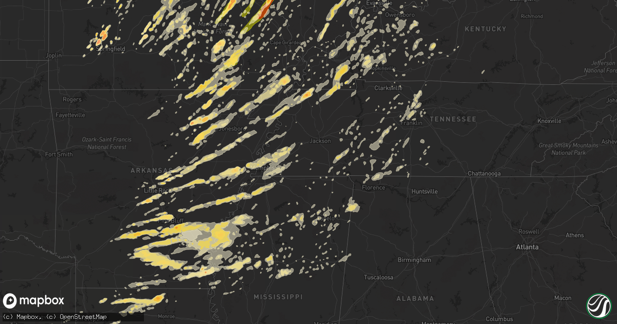
Hail Map in Ohio on May 25, 2011
Get this storm
May 25 map
$229
one time, instant access
Download today. No call, no setup
Keep the $229
Bought the map and want the full workflow? Apply the entire $229 to a subscription within 7 days. None of it is wasted.
Every map, not just this one
This buys you this map. Subscription and you get every map we run, in the markets you choose from a few cities to whole states to nationwide. Plus real-time alerts the moment a storm fires.
Contact data
Name, contact info, occupancy, even credit band for addresses in the footprint. You go from where it hit to who to call.
Become the source they trust
Unlimited branding weather history reports on demand. You already have the documented answer ready for the property owner, and you are the one who showed up with it.
Property data and RoofTrace estimates
Pull up any address you have got, its value and the exact code rules for that jurisdiction, straight from One Click Code. Then RoofTrace estimates the squares, pitch, and roof value, priced the way you price.
Storm reports in Ohio
Ohio
| Date | Description |
|---|---|
| 05/25/20116:55 PM CDT | A local report indicates 1.00 inch wind near CASTINE |
| 05/25/20116:52 PM CDT | Nickel to quarter size hail. |
| 05/25/20116:48 PM CDT | A local report indicates 1.00 inch wind near STREETSBORO |
| 05/25/20116:47 PM CDT | A local report indicates 1.75 inch wind near CEDARVILLE |
| 05/25/20116:45 PM CDT | One tree and numerous branches down. The tree fell onto a porch and destroyed the porch. |
| 05/25/20116:37 PM CDT | A local report indicates 1.00 inch wind near RICHFIELD |
| 05/25/20116:36 PM CDT | Time estimated from radar. |
| 05/25/20116:35 PM CDT | Multiple trees down on power lines/transformer on fire |
| 05/25/20116:31 PM CDT | A local report indicates 1.50 inch wind near BEAVERCREEK |
| 05/25/20116:30 PM CDT | Golf ball to baseball size hail. Extensive damage to cars and other flat surfaces exposed to the hail. Tree limbs 4-5 inches in diameter broken off. Rainfall amount 0.9 |
| 05/25/20116:29 PM CDT | A local report indicates 1.75 inch wind near 4 N SPRING VALLEY |
| 05/25/20116:28 PM CDT | A local report indicates 1.00 inch wind near BEAVERCREEK |
| 05/25/20116:28 PM CDT | Also limbs down with minor structural damage |
| 05/25/20116:28 PM CDT | A local report indicates 2.00 inch wind near XENIA |
| 05/25/20116:21 PM CDT | Time estimated from radar. |
| 05/25/20116:20 PM CDT | A local report indicates 2.00 inch wind near N BELLBROOK |
| 05/25/20116:20 PM CDT | Hail increased from 1 to 2 inches in diameter between 720 and 730 pm. |
| 05/25/20116:19 PM CDT | A local report indicates 1.00 inch wind near KETTERING |
| 05/25/20116:17 PM CDT | A local report indicates 1.75 inch wind near 1 WNW BELLBROOK |
| 05/25/20116:17 PM CDT | Nr intersection sr48/i675 |
| 05/25/20116:15 PM CDT | A local report indicates 2.00 inch wind near BELLBROOK |
| 05/25/20116:15 PM CDT | Covering the ground |
| 05/25/20116:14 PM CDT | A local report indicates 1.75 inch wind near CENTERVILLE |
| 05/25/20116:11 PM CDT | A local report indicates 3.00 inch wind near 5 ESE MIAMISBURG |
| 05/25/20116:10 PM CDT | Ef0 tornado confirmed in centerville. Trees downed and snapped on the north end of the property of miami valley hospital south. |
| 05/25/20116:06 PM CDT | Hail increased from golf ball to tennis ball size. |
| 05/25/20116:04 PM CDT | Quarter size hail and 70 mph wind gusts in miami township south of dayton mall. |
| 05/25/20116:00 PM CDT | A local report indicates 1.00 inch wind near NORWALK |
| 05/25/20116:00 PM CDT | Nr intersection i75 and i675 |
| 05/25/20115:57 PM CDT | A local report indicates 1.00 inch wind near NORTH OLMSTED |
| 05/25/20115:52 PM CDT | Also reported winds est 50 mph |
| 05/25/20115:51 PM CDT | A local report indicates 1.75 inch wind near 5 NNW MIDDLETOWN |
| 05/25/20115:49 PM CDT | A local report indicates 1.25 inch wind near 6 NW MIDDLETOWN |
| 05/25/20115:35 PM CDT | A local report indicates 1.00 inch wind near OXFORD |
| 05/25/20115:32 PM CDT | Also reported winds est 50 mph. Corrected time. |
| 05/25/20115:30 PM CDT | A local report indicates 1.00 inch wind near VERMILION |
| 05/25/20115:25 PM CDT | A local report indicates 1.75 inch wind near BLOOMVILLE |
| 05/25/20115:14 PM CDT | Trees/power lines down |
| 05/25/20115:14 PM CDT | Tornado observed by fire dept personnel briefly touching down in field. No damage observed |
| 05/25/20115:10 PM CDT | A possible tornado. A metal building totally destroyed. |
| 05/25/20115:10 PM CDT | Golf ball size hail. |
| 05/25/20115:06 PM CDT | A local report indicates 1.50 inch wind near 3 N MILAN |
| 05/25/20115:06 PM CDT | A local report indicates 1.75 inch wind near 5 S SANDUSKY |
| 05/25/20115:05 PM CDT | A local report indicates 1.00 inch wind near 3 S BELLEVUE |
| 05/25/20115:05 PM CDT | A local report indicates 1.00 inch wind near S FOSTORIA |
| 05/25/20115:00 PM CDT | A local report indicates 1.75 inch wind near 3 NE REPUBLIC |
| 05/25/20114:58 PM CDT | A local report indicates 1.00 inch wind near BLOOMVILLE |
| 05/25/20114:53 PM CDT | A local report indicates 2.75 inch wind near BELLEVUE |
| 05/25/20114:48 PM CDT | A local report indicates 2.50 inch wind near CLYDE |
| 05/25/20114:45 PM CDT | Power lines down across the ageather rd... East of kemp road and reservoir on the west side of lima |
| 05/25/20114:38 PM CDT | A local report indicates 1.75 inch wind near GREEN SPRINGS |
| 05/25/20114:17 PM CDT | A local report indicates 1.75 inch wind near FOSTORIA |
| 05/25/20114:17 PM CDT | A local report indicates 1.75 inch wind near 1 SW FOSTORIA |
| 05/25/20114:15 PM CDT | Estimated 65 mph winds blew down a five inch diameter tree onto a house. |
| 05/25/20114:15 PM CDT | A local report indicates 60 MPH wind near FOSTORIA |
| 05/25/20113:55 PM CDT | A local report indicates 1.75 inch wind near 4 SW FINDLAY |
| 05/25/20113:52 PM CDT | Broke car windows. |
| 05/25/20113:51 PM CDT | Measured 58 mph winds and ping pong size hail |
| 05/25/20113:49 PM CDT | A local report indicates 2.00 inch wind near FINDLAY |
| 05/25/20113:48 PM CDT | A local report indicates 1.75 inch wind near FINDLAY |
| 05/25/20113:45 PM CDT | Tree down. 36 inch diameter |
| 05/25/20113:43 PM CDT | A local report indicates 1.00 inch wind near FINDLAY |
| 05/25/20113:40 PM CDT | Tractor trailor blown over by e75mph winds exit 145 i75s |
| 05/25/20113:26 PM CDT | 2 trees down |
| 05/25/20113:10 PM CDT | 1 inch hail |
| 05/25/20112:26 PM CDT | Ef-0 damage to power polls along kear road. Damage path was two tenths of a mile long and 40 yards wide. Witnesses stated that the tornado was on the ground for just a |
| 05/25/20111:53 PM CDT | A local report indicates 1.00 inch wind near 2 SW ANTWERP |
| 05/25/20112:00 AM CDT | One tree down. |
| 05/25/20111:40 AM CDT | Large limb down. |
| 05/25/20111:13 AM CDT | On hamilton road |
| 05/25/20111:07 AM CDT | A local report indicates 65 MPH wind near RADNOR |
| 05/25/20111:07 AM CDT | A local report indicates 68 MPH wind near DELAWARE |
| 05/25/20111:05 AM CDT | A local report indicates 60 MPH wind near 2 S WHITEHALL |
| 05/25/20111:05 AM CDT | Some large branches down. |
| 05/25/201112:52 AM CDT | Damage to barns and a roof removed from a garage. |
| 05/25/201112:50 AM CDT | Tree and powerlines down. |
| 05/25/201112:50 AM CDT | Barn blown down on state route 568. |
| 05/25/201112:43 AM CDT | Five minutes with sustained winds 50 mph. Gusts estimated at 65 mph. |
| 05/25/201112:29 AM CDT | A local report indicates 60 MPH wind near 2 N LONDON |
| 05/25/201112:26 AM CDT | Two barns suffered roof damage... And a large tree was uprooted. The debris from one barn was strewn to the west and the other to the east. The uprooted tree was orient |
| 05/25/201112:25 AM CDT | 2 pines trees snapped off along with numerous limbs and branches broken at 4025 st. Rte 323. |
| 05/25/201112:25 AM CDT | Ef0 tornado 3 miles west of bloomingburg...with barn damage on lewis road. |
| 05/25/201112:24 AM CDT | Barn destroyed on lewis road. Time estimated. |
| 05/25/201112:15 AM CDT | Large trees down on gregg road. Time is estimated. |
| 05/25/201112:10 AM CDT | Multiple telephone poles snapped...trees downed...and a roof blown off a barn near ohio 72 and burr road. |
| 05/25/201112:01 AM CDT | Measured at nws wilmington |
| 05/24/201111:57 PM CDT | A barn was damaged with pieces blown into nearby fields. |
| 05/24/201111:55 PM CDT | A barn was damaged on gurneyville road northwest of wilmington. Part of the roof was blown off. Numerous trees downed. |
| 05/24/201111:54 PM CDT | Dime size hail. |
| 05/24/201111:53 PM CDT | Trees and power poles downed on state route 380. |
| 05/24/201111:45 PM CDT | Corrected time. |
| 05/24/201111:45 PM CDT | Tree limbs down. Corrected time. |
| 05/24/201111:40 PM CDT | Large branches snapped from trees along interstate 75 just south of the kyles station road overpass. |
| 05/24/201111:37 PM CDT | A local report indicates 61 MPH wind near KVES VERSAILLES APT |
| 05/24/201111:34 PM CDT | Multiple trees downed along glendale drive. |
| 05/24/201111:32 PM CDT | Peak gust at lunken airport asos |
| 05/24/201111:30 PM CDT | Entire roof lifted from single family home and carried approximately 200 yards. Automobile flipped over with another moved by winds. A separate home suffered lifting of |
| 05/24/201111:27 PM CDT | Two very large trees 2-3 feet in diameter were snapped off. |
| 05/24/201111:25 PM CDT | Numerous tree branches snapped...along with siding and minor roof damage to several homes in the greenbrier subdivision. |
| 05/24/201111:22 PM CDT | 2 homes heavily damaged. 5 homes moderately damaged. 1 overturned vehicle. |
| 05/24/201111:21 PM CDT | A local report indicates 1.75 inch wind near WARREN |
| 05/24/201111:20 PM CDT | A number of structures sustained roof and chimney damage... And a carport collapsed. Large trees as big as 5 feet in diameter were snapped and uprooted. 20 cars were da |
| 05/24/201111:20 PM CDT | A local report indicates 1.25 inch wind near WARREN |
| 05/24/201111:11 PM CDT | Trees down. |
| 05/24/201111:10 PM CDT | Trees twisted and powers knocked down. |
| 05/24/201110:58 PM CDT | A local report indicates 1.75 inch wind near 3 S RAVENNA |
| 05/24/201110:45 PM CDT | A local report indicates 1.00 inch wind near FAIRFAX |
| 05/24/201110:45 PM CDT | Tree limbs down |
| 05/24/201110:29 PM CDT | Trees and power lines down in city...blocking walnut and harrison streets. |
| 05/24/201110:15 PM CDT | Several large trees down |
| 05/24/201110:09 PM CDT | Trees were also reported down county wide. |
| 05/24/201110:09 PM CDT | Measured brief 60 mph gust in west jefferson |
| 05/24/20119:44 PM CDT | Trees down. Corrected time. |
| 05/24/20119:23 PM CDT | A local report indicates 1.00 inch wind near DELAWARE |
| 05/24/20119:19 PM CDT | Tree down on mason rd. |
| 05/24/20119:17 PM CDT | Trees down along miami-shelby rd. Corrected time. |
| 05/24/20119:15 PM CDT | A local report indicates 1.00 inch wind near OSTRANDER |
| 05/24/20119:12 PM CDT | A local report indicates 1.75 inch wind near 8 SE MARYSVILLE |
| 05/24/20119:07 PM CDT | Quarter size hail. |
| 05/24/20119:05 PM CDT | A local report indicates 61 MPH wind near PLAIN CITY |
| 05/24/20119:00 PM CDT | A local report indicates 59 MPH wind near JACKSON CENTER |
| 05/24/20118:57 PM CDT | A local report indicates 1.00 inch wind near MARYSVILLE |
| 05/24/20118:57 PM CDT | A local report indicates 1.00 inch wind near 1 E COVINGTON |
| 05/24/20118:47 PM CDT | Ping pong ball size hail. |
| 05/24/20118:36 PM CDT | Also 45-50 mph winds |
| 05/24/20118:35 PM CDT | A local report indicates 1.00 inch wind near 1 N GREENVILLE |
| 05/24/20118:34 PM CDT | Also half inch hail |
| 05/24/20118:30 PM CDT | A local report indicates 1.75 inch wind near GREENVILLE |
| 05/24/20118:19 PM CDT | A local report indicates 1.25 inch wind near 2 E NEW MADISON |
| 05/24/20117:55 PM CDT | Tree down on 3600 block of lefevre rd. |
| 05/24/20117:47 PM CDT | A local report indicates 1.00 inch wind near CANTON |
| 05/24/20117:47 PM CDT | A local report indicates 1.00 inch wind near VANDALIA |
| 05/24/20117:45 PM CDT | Large limb down. |
| 05/24/20117:41 PM CDT | A local report indicates 1.75 inch wind near CLAYTON |
| 05/24/20117:41 PM CDT | Largest hailstone the spotter observed. |
| 05/24/20117:39 PM CDT | A local report indicates 1.75 inch wind near ENGLEWOOD |
| 05/24/20117:34 PM CDT | A local report indicates 1.75 inch wind near BROOKVILLE |
| 05/24/20117:24 PM CDT | A local report indicates 1.00 inch wind near 1 NW NEW LEBANON |
| 05/24/20117:23 PM CDT | A local report indicates 1.00 inch wind near WEST ALEXANDRIA |
| 05/24/20117:22 PM CDT | A local report indicates 1.75 inch wind near HIRAM |
| 05/24/20117:20 PM CDT | Tree on a house. |
| 05/24/20117:20 PM CDT | Hail rapidly increased from pea size to golf ball size. |
| 05/24/20117:16 PM CDT | Several trees down |
| 05/24/20117:15 PM CDT | A local report indicates 1.00 inch wind near 5 SSE EATON |
| 05/24/20117:00 PM CDT | Roofs reported off industrial buildings. Also gutters torn off buildings. |
All States Impacted by Hail Map on May 25, 2011
Cities Impacted by Hail Map on May 25, 2011
- Brighton, IL
- Climax Springs, MO
- Edwards, MO
- Trafalgar, IN
- Nineveh, IN
- Nashville, IN
- Morgantown, IN
- Obion, TN
- South Fulton, TN
- Rives, TN
- Union City, TN
- Fulton, KY
- Hornbeak, TN
- Troy, TN
- Coushatta, LA
- Dawson Springs, KY
- Hamburg, AR
- Bernie, MO
- Dexter, MO
- Vandalia, IL
- Kampsville, IL
- Hartford City, IN
- Muncie, IN
- Upland, IN
- Francesville, IN
- Spencerville, IN
- Fort Wayne, IN
- Grabill, IN
- Harlan, IN
- Woodburn, IN
- New Haven, IN
- Tunica, MS
- Meta, MO
- Dixon, MO
- Argyle, MO
- Vienna, MO
- Brinktown, MO
- Connersville, IN
- Centerville, IN
- Cord, AR
- Brownsville, TN
- Colfax, LA
- Troy, MO
- Moscow Mills, MO
- Foristell, MO
- Wentzville, MO
- Old Monroe, MO
- Harrisburg, IL
- Noble, IL
- Florence, AL
- Iron City, TN
- Killen, AL
- Jena, LA
- Piedmont, MO
- Rison, AR
- Cortland, OH
- Spring Valley, OH
- Xenia, OH
- Dayton, OH
- Bellbrook, OH
- Gore Springs, MS
- Duck Hill, MS
- Atlanta, IL
- Wapella, IL
- Clinton, IL
- Waynesville, IL
- McLean, IL
- Kenney, IL
- Heyworth, IL
- Rittman, OH
- Wadsworth, OH
- Doylestown, OH
- Cotton Valley, LA
- Benton, LA
- Romance, AR
- Rose Bud, AR
- Sikeston, MO
- Essex, MO
- Bell City, MO
- Vanduser, MO
- Bloomfield, MO
- Creston, OH
- Seville, OH
- Sidon, MS
- Greenwood, MS
- Brookville, IN
- Oxford, OH
- Cedar Grove, IN
- Doniphan, MO
- Strawberry, AR
- Poughkeepsie, AR
- Batesville, AR
- Alicia, AR
- Smithville, AR
- Sulphur Rock, AR
- Cave City, AR
- Walnut Ridge, AR
- Hoxie, AR
- Portia, AR
- Black Rock, AR
- Lynn, AR
- Powhatan, AR
- Bloomington, IN
- Lovington, IL
- Baring, MO
- Ashland, OH
- New London, OH
- Nova, OH
- Sullivan, OH
- Greenville, MS
- Benoit, MS
- Oak Harbor, OH
- Port Clinton, OH
- Piasa, IL
- Shipman, IL
- Medora, IL
- Griffithville, AR
- Searcy, AR
- Cambridge Springs, PA
- Union City, PA
- Thornton, AR
- Bearden, AR
- Avon, OH
- Olmsted Falls, OH
- North Olmsted, OH
- North Ridgeville, OH
- Westlake, OH
- Shelby, MS
- Clarksdale, MS
- Mexico, MO
- Miller City, IL
- Charleston, MO
- Cairo, IL
- Osceola, MO
- Lowry City, MO
- West Plains, MO
- Attica, OH
- Bloomville, OH
- Tiffin, OH
- Republic, OH
- Cole Camp, MO
- Oakland, MS
- Water Valley, MS
- Bauxite, AR
- Bryant, AR
- New Riegel, OH
- Weimar, TX
- Schulenburg, TX
- Deville, LA
- Pineville, LA
- Ball, LA
- Center Point, LA
- Marksville, LA
- Effie, LA
- South Bend, IN
- Merigold, MS
- Beulah, MS
- Cleveland, MS
- Belleville, IL
- Freeburg, IL
- Tamms, IL
- Thebes, IL
- Olive Branch, IL
- Villa Ridge, IL
- Pulaski, IL
- Mounds, IL
- Bernice, LA
- Morrisville, MO
- Brighton, MO
- Willard, MO
- Walnut Grove, MO
- Waynesville, MO
- Lebanon, MO
- Falcon, MO
- Laquey, MO
- Ledbetter, TX
- Giddings, TX
- West Lafayette, IN
- Ellington, MO
- Gosport, IN
- Corunna, IN
- Kendallville, IN
- Avilla, IN
- Jacksonville, AR
- Converse, LA
- Pine Bluff, AR
- Malvern, AR
- Sherrill, AR
- Leola, AR
- Jefferson, AR
- Grapevine, AR
- Sheridan, AR
- Arkadelphia, AR
- White Hall, AR
- Carthage, AR
- Payne, OH
- Antwerp, OH
- Cascilla, MS
- Arnold, MO
- Imperial, MO
- Marysville, OH
- Van Buren, MO
- Edinburg, IL
- Barry, IL
- New Canton, IL
- Oakdale, IL
- Nashville, IL
- Guthrie, KY
- Trenton, KY
- Crowley, LA
- Ganado, TX
- Markle, IN
- Bluffton, IN
- Uniondale, IN
- Roanoke, IN
- Huntington, IN
- Ossian, IN
- Salem, IL
- Iuka, IL
- Oil Trough, AR
- Martinsville, IL
- Marshall, IL
- Rosedale, IN
- Mammoth Spring, AR
- Camp, AR
- Glencoe, AR
- Couch, MO
- Alton, MO
- Ravenden, AR
- Myrtle, MO
- Osage Beach, MO
- Sunrise Beach, MO
- Newport, AR
- Newark, AR
- Conroe, TX
- Cleveland, TX
- Lexa, AR
- Poplar Grove, AR
- Hornbeck, LA
- Milroy, IN
- Rushville, IN
- Greensburg, IN
- Napoleon, MO
- Bates City, MO
- Oak Grove, MO
- Biscoe, AR
- Des Arc, AR
- Stover, MO
- Smithton, MO
- Warsaw, MO
- Florence, MO
- Lincoln, MO
- Mora, MO
- Ashkum, IL
- Castalia, OH
- Vickery, OH
- Sandusky, OH
- Huron, OH
- Old Fort, OH
- Clyde, OH
- Milan, OH
- Fremont, OH
- Monroeville, OH
- Green Springs, OH
- Bellevue, OH
- Berlin Heights, OH
- Grady, AR
- Bloomsdale, MO
- Wakeman, OH
- Vermilion, OH
- Paoli, IN
- French Lick, IN
- Morral, OH
- Marion, OH
- Sainte Genevieve, MO
- Rochester, IL
- Rocheport, MO
- Mulberry Grove, IL
- Ramsey, IL
- Beecher, IL
- Grovespring, MO
- Bloomfield, IN
- Shelbyville, TX
- Tipton, IN
- Odessa, MO
- Lone Jack, MO
- Vulcan, MO
- Montgomery, IN
- Plainville, IN
- Loogootee, IN
- Elnora, IN
- Washington, IN
- Owensburg, IN
- Crane, IN
- Odon, IN
- Springville, IN
- Worthington, IN
- Millington, TN
- Wabash, IN
- Maynard, AR
- Oxly, MO
- Okeana, OH
- Anahuac, TX
- Winnie, TX
- Robertsville, MO
- Parker City, IN
- Albany, IN
- Gibsonburg, OH
- Luckey, OH
- Woodville, OH
- Pemberville, OH
- Genoa, OH
- Ridgely, TN
- Mascoutah, IL
- Pawnee, IL
- Mount Blanchard, OH
- New Lebanon, OH
- Duke, MO
- Newburg, MO
- Devils Elbow, MO
- Palacios, TX
- Blessing, TX
- Columbia City, IN
- Spencer, IN
- Solsberry, IN
- Castor, LA
- New Madrid, MO
- Hiram, OH
- Jonesburg, MO
- Warrenton, MO
- Raymondville, MO
- Frankfort, IN
- Cutler, IN
- Russiaville, IN
- Woodville, MS
- Henning, TN
- Ellettsville, IN
- Delphi, IN
- Brookston, IN
- Brookville, OH
- Cedarville, OH
- Wilberforce, OH
- Alpha, OH
- Eolia, MO
- Silex, MO
- Fulton, MO
- Roundhill, KY
- Brownsville, KY
- Sweeden, KY
- Ringgold, LA
- Jamestown, LA
- Goldonna, LA
- Saline, LA
- Ashland, LA
- Hall Summit, LA
- San Augustine, TX
- Ravenna, OH
- Williams, IN
- Matthews, MO
- Lilbourn, MO
- Mansfield, LA
- Pelican, LA
- Natchitoches, LA
- Natchez, LA
- Robeline, LA
- Pleasant Hill, LA
- Noble, LA
- Marthaville, LA
- Saint Louis, MO
- Warren, OH
- Newton Falls, OH
- Leavittsburg, OH
- Niles, OH
- Pevely, MO
- Festus, MO
- Hillsboro, MO
- Milmine, IL
- Monticello, IL
- Belzoni, MS
- Collierville, TN
- Germantown, TN
- Rossville, TN
- Eads, TN
- Memphis, TN
- Cordova, TN
- Alhambra, IL
- Marine, IL
- Westphalia, MO
- Saint Thomas, MO
- Billings, MO
- Republic, MO
- Bastrop, TX
- Paige, TX
- Garwood, TX
- Louise, TX
- Hallettsville, TX
- Woodstock, OH
- Milford Center, OH
- North Lewisburg, OH
- Ethel, MS
- Vaiden, MS
- Kilmichael, MS
- Plain City, OH
- Lizton, IN
- Jamestown, IN
- Minter City, MS
- Belleview, MO
- Cadet, MO
- Mineral Point, MO
- Bonne Terre, MO
- Belgrade, MO
- De Soto, MO
- Potosi, MO
- Blackwell, MO
- Bixby, MO
- Cabot, AR
- Elyria, OH
- Pope, MS
- Enid, MS
- Batesville, MS
- Courtland, MS
- Bowling Green, IN
- Coal City, IN
- Centerpoint, IN
- Clay City, IN
- Bentley, LA
- Dry Prong, LA
- Cloutierville, LA
- Montgomery, LA
- Shelbyville, IN
- Indianapolis, IN
- Greenwood, IN
- New Palestine, IN
- Boggstown, IN
- Whiteland, IN
- Franklin, IN
- Needham, IN
- Fairland, IN
- Bargersville, IN
- Martinsville, IN
- Lyon, MS
- Coahoma, MS
- Springfield, MO
- Chrisman, IL
- South Charleston, OH
- South Solon, OH
- Calhoun, MO
- Windsor, MO
- West Alexandria, OH
- Farmersville, OH
- Vienna, IL
- Stonefort, IL
- Simpson, IL
- Ozark, IL
- Grantsburg, IL
- Mayfield, KY
- West College Corner, IN
- Louisville, MS
- Ingraham, IL
- Dieterich, IL
- Newton, IL
- Clifford, IN
- Flat Rock, IN
- Hope, IN
- Columbus, IN
- Tatum, TX
- Henderson, TX
- Beckville, TX
- Chester, IL
- Steeleville, IL
- Kenton, OH
- Columbus, TX
- Ash Grove, MO
- Lakeview, OH
- Perryville, MO
- Mulberry, IN
- Greenville, OH
- Gettysburg, OH
- Bradford, OH
- Nashville, TN
- Kokomo, IN
- Kempton, IN
- Sharpsville, IN
- Portland, AR
- Montrose, AR
- Lake Village, AR
- Viburnum, MO
- Steelville, MO
- Marion, IN
- Itta Bena, MS
- Schlater, MS
- Ecru, MS
- New Albany, MS
- Grandin, MO
- Fairdealing, MO
- Stockdale, TX
- Nixon, TX
- Bucyrus, OH
- Fayette, AL
- Berry, AL
- Bankston, AL
- Centerburg, OH
- Sunbury, OH
- Marengo, OH
- Somerville, OH
- West Harrison, IN
- Laurel, IN
- Germantown, OH
- Metamora, IN
- Hamilton, OH
- Bath, IN
- Franklin, OH
- Middletown, OH
- Miamisburg, OH
- Sunman, IN
- College Corner, OH
- Trenton, OH
- Liberty, IN
- Scott, AR
- Jasper, AL
- Houston, MO
- Cabool, MO
- Solo, MO
- Mountain Grove, MO
- Edna, TX
- Sheridan, TX
- Madison, IL
- Fenton, MO
- Chesterfield, MO
- Ballwin, MO
- Valley Park, MO
- Granite City, IL
- Venice, IL
- Decaturville, TN
- Starkville, MS
- Beebe, AR
- Danville, IL
- Oakwood, IL
- Bronson, TX
- Hemphill, TX
- Milam, TX
- Franklin, TN
- Lillie, LA
- Spearsville, LA
- League City, TX
- New Haven, IL
- Ridgway, IL
- Cotton Plant, AR
- Hazen, AR
- Carlisle, AR
- Laddonia, MO
- Greencastle, IN
- Placedo, TX
- Bloomington, TX
- Jadwin, MO
- Salem, MO
- Mitchell, IN
- Greenfield, IN
- Owensville, IN
- Velpen, IN
- Norman, IN
- Stinesville, IN
- Avoca, IN
- Shoals, IN
- Princeton, IN
- Jasper, IN
- Patoka, IN
- Heltonville, IN
- Oolitic, IN
- Hartsville, IN
- Saint Paul, IN
- Edinburgh, IN
- Fountaintown, IN
- Mooresville, IN
- Freedom, IN
- Lyons, IN
- Bedford, IN
- Manilla, IN
- Oldenburg, IN
- Wheatland, IN
- Newberry, IN
- Switz City, IN
- Freetown, IN
- Huntingburg, IN
- Waldron, IN
- Monroe City, IN
- Paragon, IN
- Taylorsville, IN
- Hazleton, IN
- Vincennes, IN
- Decker, IN
- Seymour, IN
- Batesville, IN
- Winslow, IN
- Okolona, MS
- Shannon, MS
- Almyra, AR
- Crocketts Bluff, AR
- Stuttgart, AR
- Humphrey, AR
- Casscoe, AR
- Eminence, MO
- Metropolis, IL
- Niangua, MO
- Hartville, MO
- Evansville, IN
- Cisco, IL
- Cerro Gordo, IL
- Otterbein, IN
- Derby, IN
- Liberty, TX
- Licking, MO
- Beulah, MO
- Edgar Springs, MO
- Success, MO
- Roby, MO
- Seymour, IL
- Weldon, IL
- Mansfield, IL
- Champaign, IL
- Sadorus, IL
- De Land, IL
- Rantoul, IL
- Thomasboro, IL
- Bondville, IL
- Fisher, IL
- White Heath, IL
- Dewey, IL
- Ivesdale, IL
- Urbana, IL
- Savoy, IL
- Mahomet, IL
- Tolono, IL
- Windham, OH
- Mantua, OH
- Garrettsville, OH
- Lohman, MO
- Russellville, MO
- Rocky Mount, MO
- Gravois Mills, MO
- Olean, MO
- Centertown, MO
- Latham, MO
- Jefferson City, MO
- California, MO
- Versailles, MO
- Eldon, MO
- Barnett, MO
- Straughn, IN
- New Castle, IN
- New Washington, OH
- Mill Spring, MO
- Ellsinore, MO
- Williamsville, MO
- Pocahontas, IL
- Breese, IL
- Pleasant Hill, IL
- Annada, MO
- Hawk Point, MO
- Bowling Green, MO
- Elsberry, MO
- Pearl, IL
- Middletown, MO
- Nebo, IL
- Hamburg, IL
- Clarksville, MO
- Truxton, MO
- Yuma, TN
- Lexington, TN
- Wildersville, TN
- Lisbon, LA
- Farmerville, LA
- Minden, LA
- Homer, LA
- Dubach, LA
- Marion, LA
- Lolita, TX
- Somerville, TN
- Morristown, IN
- Carthage, IN
- Arlington, IN
- Oxford, MS
- Osgood, IN
- Westfield, IN
- Hillview, IL
- Browns, IL
- Mount Carmel, IL
- Yorktown, TX
- Foley, MO
- Ruleville, MS
- Spring Valley, IL
- Granville, IL
- Atlanta, IN
- Montgomery City, MO
- Wellsville, MO
- Bellflower, MO
- Texico, IL
- Mount Vernon, IL
- Walnut Hill, IL
- Dix, IL
- Kell, IL
- Seymour, MO
- Linden, TN
- Berger, MO
- Gas City, IN
- Fowlerton, IN
- Summitville, IN
- Fairmount, IN
- Jonesboro, IN
- Charleston, MS
- Lovejoy, IL
- Culver, IN
- Syracuse, IN
- Milford, IN
- Windfall, IN
- Elwood, IN
- Romney, IN
- Crawfordsville, IN
- Lafayette, IN
- New Richmond, IN
- Clarks Hill, IN
- Linden, IN
- Dickson, TN
- Widener, AR
- Wynne, AR
- Colt, AR
- Parkin, AR
- Heth, AR
- Palestine, AR
- Earle, AR
- Forrest City, AR
- Eddyville, KY
- Van Buren, IN
- Piqua, OH
- Houston, OH
- Hinckley, OH
- Upper Sandusky, OH
- Nevada, OH
- Findlay, OH
- Middletown, IN
- Shirley, IN
- Gonzales, TX
- Shiner, TX
- Urbana, OH
- Springfield, OH
- Tremont City, OH
- Bluffton, OH
- Defiance, MO
- O'Fallon, MO
- Lake Saint Louis, MO
- Watson, AR
- Olmstead, KY
- Fort Leonard Wood, MO
- Vichy, MO
- Freeburg, MO
- Richland, MO
- Belle, MO
- Jerome, MO
- Crocker, MO
- Rolla, MO
- Saint Robert, MO
- Linn, MO
- Brazil, IN
- Whites Creek, TN
- Ironton, MO
- Annapolis, MO
- Morocco, IN
- Lima, OH
- Springboro, OH
- Paris, IL
- Little Rock, AR
- Roland, AR
- Ottawa, OH
- Leipsic, OH
- Cross Timbers, MO
- Sycamore, OH
- Mechanicsburg, OH
- Horseshoe Bend, AR
- Carey, OH
- Demotte, IN
- Rossville, IN
- Bringhurst, IN
- Reynolds, IN
- Chalmers, IN
- Monticello, IN
- Zwolle, LA
- Blytheville, AR
- Caruthersville, MO
- Steele, MO
- Cooter, MO
- Florien, LA
- Leesville, LA
- Boyce, LA
- Elmer, LA
- Lena, LA
- Flatwoods, LA
- Mora, LA
- Monterey, LA
- Alexandria, LA
- Provencal, LA
- Acme, LA
- Pollock, LA
- Jonesville, LA
- Fortuna, MO
- East Liberty, OH
- Tutwiler, MS
- Lambert, MS
- Williamstown, OH
- Forest, OH
- Dunkirk, OH
- Arlington, OH
- Waynetown, IN
- Crete, IL
- Cleveland, OH
- Independence, OH
- Elkland, MO
- Gillett, AR
- Tichnor, AR
- De Witt, AR
- Gould, AR
- Yorktown, AR
- Star City, AR
- Beaumont, TX
- Plainfield, IN
- Clayton, IN
- Moreauville, LA
- Danville, IN
- Coatesville, IN
- Benton, KY
- Crofton, KY
- Russellville, AL
- Pontotoc, MS
- Alexander, AR
- Ravenden Springs, AR
- Imboden, AR
- Arlington, KY
- Everton, MO
- Prospect, OH
- Wheatley, AR
- Goodwin, AR
- Hume, IL
- Brentwood, TN
- Spiceland, IN
- Knightstown, IN
- Hampton, AR
- Antioch, TN
- Van Wert, OH
- Mentone, IN
- Claypool, IN
- Burket, IN
- Counce, TN
- Shiloh, TN
- Moscow, TX
- Mabelvale, AR
- Benton, AR
- Naylor, MO
- Edinboro, PA
- Saegertown, PA
- Venango, PA
- Little York, IL
- Poplar Bluff, MO
- Patterson, MO
- Arbela, MO
- Midfield, TX
- Bay City, TX
- Bolivar, MO
- Marshall, IN
- Bloomingdale, IN
- Montezuma, IN
- New Waverly, TX
- Huntsville, TX
- Thaxton, MS
- Randolph, MS
- Paris, MS
- Houlka, MS
- Andrews, IN
- Pasadena, TX
- Adamsville, TN
- Milledgeville, TN
- Morris Chapel, TN
- Bethel Springs, TN
- Sardis, TN
- Carlinville, IL
- Gillespie, IL
- Greenville, MO
- Marquand, MO
- Clubb, MO
- Silva, MO
- Crumrod, AR
- Duncan, MS
- Alligator, MS
- Addieville, IL
- Richmond, IN
- Amo, IN
- Eaton, OH
- Dumas, AR
- Wilmar, AR
- Snow Lake, AR
- McGehee, AR
- Tillar, AR
- Kingsland, AR
- Mellwood, AR
- Fordyce, AR
- Gunnison, MS
- New Edinburg, AR
- Monticello, AR
- Rosedale, MS
- Pickens, AR
- Rohwer, AR
- Mound Bayou, MS
- Winchester, AR
- Portageville, MO
- Altheimer, AR
- Wabbaseka, AR
- Miller, MO
- Creve Coeur, IL
- Pekin, IL
- East Peoria, IL
- Evansville, IL
- Modoc, IL
- Providence, KY
- Dixon, KY
- Coffeeville, MS
- Redfield, AR
- Hensley, AR
- Nokomis, IL
- Grovertown, IN
- Knox, IN
- Columbus Grove, OH
- Cecil, OH
- Paulding, OH
- Lakewood, IL
- Shelbyville, IL
- Strasburg, IL
- Buffalo, IL
- Eldorado, OH
- New Paris, OH
- Marthasville, MO
- Hopkinsville, KY
- Weiner, AR
- Fisher, AR
- Crenshaw, MS
- Sledge, MS
- Venedocia, OH
- Ada, OH
- Vanlue, OH
- Wharton, OH
- Dola, OH
- Arcanum, OH
- Tuscumbia, AL
- Parma, MO
- Bremen, AL
- Saint Mary, MO
- Farmington, MO
- Fredericktown, MO
- Pinckneyville, IL
- Tilden, IL
- Ellis Grove, IL
- Baldwin, IL
- Marissa, IL
- Sparta, IL
- Coulterville, IL
- Walsh, IL
- Hannibal, MO
- Monroe City, MO
- Palmyra, MO
- Center, MO
- Perry, MO
- Shreveport, LA
- Yoakum, TX
- Union Hill, IL
- Herscher, IL
- Buckingham, IL
- Bonfield, IL
- Vina, AL
- Goliad, TX
- Preston, MO
- Hermitage, MO
- Culleoka, TN
- Columbia, TN
- Spring Hill, TN
- Wilson, LA
- Clinton, LA
- Jetson, KY
- Caneyville, KY
- Shelby, OH
- Mansfield, OH
- Shiloh, OH
- Cuba, MO
- Hartville, OH
- Akron, OH
- Kent, OH
- Clinton, OH
- Canal Fulton, OH
- Massillon, OH
- Rootstown, OH
- Uniontown, OH
- Atwater, OH
- Alliance, OH
- Mogadore, OH
- North Canton, OH
- Boss, MO
- Roach, MO
- Camdenton, MO
- Waggoner, IL
- Divernon, IL
- Girard, IL
- Farmersville, IL
- Harvel, IL
- Morrisonville, IL
- Virden, IL
- Mechanicsburg, IL
- Millstadt, IL
- Palmyra, IL
- High Hill, MO
- Leighton, AL
- Splendora, TX
- Hankamer, TX
- Bedias, TX
- Dayton, TX
- Willis, TX
- Devers, TX
- Norwalk, OH
- Collins, OH
- New Carlisle, OH
- Fostoria, OH
- Teutopolis, IL
- Winona, MO
- Redford, MO
- Plato, MO
- Marianna, AR
- North Baltimore, OH
- Cygnet, OH
- Jerry City, OH
- West Terre Haute, IN
- Terre Haute, IN
- Dennison, IL
- Navasota, TX
- Anderson, TX
- Xenia, IL
- Kinmundy, IL
- Hazel, KY
- Murray, KY
- Clinton, IN
- Hillsdale, IN
- Vermilion, IL
- Arcola, IL
- Humboldt, IL
- Tuscola, IL
- Pesotum, IL
- Arthur, IL
- Veedersburg, IN
- Kingman, IN
- Hillsboro, IN
- Swifton, AR
- Churubusco, IN
- Yoder, IN
- Arcola, IN
- South Whitley, IN
- Cabery, IL
- Kempton, IL
- Burton, TX
- Clinton, MO
- Peace Valley, MO
- Birch Tree, MO
- Roachdale, IN
- Pulaski, TN
- Gideon, MO
- Ward, AR
- Salem, KY
- Warren, IN
- Greentown, IN
- Swayzee, IN
- Sheridan, IN
- Tallula, IL
- New Madison, OH
- West Manchester, OH
- Memphis, MO
- Findlay, IL
- Windsor, IL
- Tower Hill, IL
- Cowden, IL
- Gardner, IL
- Dwight, IL
- Athens, LA
- Simsboro, LA
- Arcadia, LA
- Downsville, LA
- Ruston, LA
- Gibsland, LA
- Arcadia, OH
- Alvada, OH
- Risingsun, OH
- Rawson, OH
- Van Buren, OH
- Kansas, OH
- Bloomdale, OH
- McComb, OH
- Lonoke, AR
- Madison, AR
- Brinkley, AR
- Crawfordsville, AR
- Anacoco, LA
- Many, LA
- Sherwood, AR
- Kansas City, MO
- Pocahontas, AR
- Hardy, AR
- Lodi, MO
- Success, AR
- Harviell, MO
- Fremont, MO
- Thayer, MO
- Neelyville, MO
- Warm Springs, AR
- Gatewood, MO
- Price, TX
- Cave City, KY
- Horse Cave, KY
- Grand Chain, IL
- Stilesville, IN
- Franklin, AR
- Melbourne, AR
- Grand Rivers, KY
- Marion, AR
- Westhoff, TX
- Royal Center, IN
- Salem, AR
- Lafe, AR
- Marmaduke, AR
- Paragould, AR
- Rector, AR
- Albion, PA
- Madison, TN
- El Dorado, AR
- Junction City, AR
- Belton, MO
- Grandview, MO
- Crestline, OH
- Oakland, IL
- Camargo, IL
- Hindsboro, IL
- Charleston, IL
- Newman, IL
- Carmine, TX
- Falkner, MS
- Tiplersville, MS
- Aberdeen, MS
- Centralia, IL
- Independence, MO
- Millport, AL
- Steens, MS
- Columbus, MS
- Ethelsville, AL
- Lamar, IN
- Chrisney, IN
- Sturdivant, MO
- Old Hickory, TN
- Chesterton, IN
- Ulman, MO
- Ora, IN
- Monterey, IN
- Clayton, IL
- Bois D Arc, MO
- Jersey, AR
- Hermitage, AR
- Fountain Hill, AR
- Drew, MS
- Banks, AR
- Camden, AR
- Harrell, AR
- Warren, AR
- Celina, OH
- Mendon, OH
- Rockford, OH
- Powell, OH
- Ostrander, OH
- Delaware, OH
- Tremont, MS
- Lenox, MO
- Amboy, IN
- Whitesville, KY
- Fordsville, KY
- Hartford, KY
- Reynolds Station, KY
- South Vienna, OH
- London, OH
- Fairborn, OH
- Yellow Springs, OH
- Norwood, MO
- Marvell, AR
- Linton, IN
- Jasonville, IN
- Portland, MO
- Rhineland, MO
- Ludlow Falls, OH
- Troy, OH
- West Milton, OH
- Waverly, IL
- Auburn, IL
- Coldwater, MS
- Hernando, MS
- Raleigh, IL
- Galatia, IL
- Clifton, TN
- Hermitage, TN
- Edgewood, IL
- Farina, IL
- Louisville, IL
- Austin, AR
- Vilonia, AR
- McRae, AR
- Garner, AR
- Leopold, MO
- Marble Hill, MO
- Wickliffe, KY
- Barlow, KY
- Butler, IN
- Greenway, AR
- Piggott, AR
- Bunceton, MO
- Newburgh, IN
- Boonville, IN
- Chandler, IN
- Woodlawn, IL
- Macks Creek, MO
- Ohio City, OH
- Decatur, IN
- Monroe, IN
- Willshire, OH
- England, AR
- Normal, IL
- Towanda, IL
- Gurdon, AR
- New London, MO
- Bardwell, KY
- Perrysville, IN
- Covington, IN
- Sorento, IL
- Greenville, IL
- Daleville, IN
- Yorktown, IN
- Sparkman, AR
- Vidalia, LA
- Owensboro, KY
- Selmer, TN
- Saltillo, TN
- Scotts Hill, TN
- Finger, TN
- Enville, TN
- Portland, IN
- Clay, KY
- Slaughters, KY
- West Salem, OH
- Polk, OH
- Pendleton, IN
- Rochester, KY
- Morgantown, KY
- Lewisville, IN
- Cambridge City, IN
- Harpster, OH
- Willow Springs, MO
- Liberty, IL
- Sullivan, MO
- Bourbon, MO
- Dittmer, MO
- Oconee, IL
- Pana, IL
- Hickman, KY
- Wright City, MO
- Fayetteville, TN
- Belknap, IL
- Brenham, TX
- Sims, IL
- Cisne, IL
- Inez, TX
- Victoria, TX
- Lostant, IL
- Hagerstown, IN
- Milton, IN
- Falmouth, IN
- Cuero, TX
- Olivehill, TN
- Bono, AR
- Cash, AR
- Bastrop, LA
- Belden, MS
- Tupelo, MS
- Linn Creek, MO
- West Helena, AR
- Helena, AR
- Loudonville, OH
- Goodlettsville, TN
- Cedar Hill, MO
- House Springs, MO
- West Farmington, OH
- Middlefield, OH
- Southington, OH
- Burton, OH
- Attica, IN
- Belmont, LA
- Santa Fe, MO
- Argenta, IL
- Beecher City, IL
- Urbana, MO
- Louisburg, MO
- Vienna, OH
- Aurora, OH
- Diamond, OH
- Fowler, OH
- Macedonia, OH
- Hudson, OH
- Brookfield, OH
- Twinsburg, OH
- Kinsman, OH
- Streetsboro, OH
- Burghill, OH
- Sherwood, OH
- Arcadia, MO
- Economy, IN
- Greens Fork, IN
- Williamsburg, IN
- Dudley, MO
- Kankakee, IL
- Trumann, AR
- Leasburg, MO
- Sterlington, LA
- Mount Vernon, OH
- Marion, KY
- La Fontaine, IN
- White House, TN
- Greenbrier, TN
- Washington, MO
- Mason, TN
- Covington, TN
- La Grange, TX
- Smithville, TX
- Tipton, MO
- Clarksburg, MO
- Piper City, IL
- Cullom, IL
- Forrest, IL
- Emington, IL
- Reddick, IL
- East Saint Louis, IL
- Columbia, IL
- Waterloo, IL
- Continental, OH
- Golden, MS
- Red Bay, AL
- Union City, OH
- Ansonia, OH
- Brunswick, OH
- Peninsula, OH
- Brecksville, OH
- Richfield, OH
- Northfield, OH
- Broadview Heights, OH
- Medina, OH
- North Royalton, OH
- Red Bud, IL
- New Athens, IL
- Benton Ridge, OH
- Bascom, OH
- Jenera, OH
- Mount Cory, OH
- Duck River, TN
- Centerville, TN
- Brighton, TN
- Arlington, TN
- Griffin, IN
- Harrod, OH
- Petersburg, TN
- Shelbyville, TN
- Mansfield, MO
- Saint Charles, MO
- Saint Peters, MO
- Golden Eagle, IL
- Brussels, IL
- Labadie, MO
- Augusta, MO
- Black Oak, AR
- Lake City, AR
- Lebanon, IN
- Bethalto, IL
- Bucyrus, MO
- Peru, IN
- Fieldon, IL
- Kane, IL
- Carrollton, IL
- Eldred, IL
- Summersville, MO
- Carlyle, IL
- Bartelso, IL
- Otwell, IN
- Neoga, IL
- Gays, IL
- Mattoon, IL
- Radnor, OH
- Lagrange, OH
- Petroleum, IN
- Leo, IN
- Alger, OH
- Burgoon, OH
- Keystone, IN
- Lorain, OH
- Albion, IN
- Converse, IN
- Monroeville, IN
- Haviland, OH
- Gomer, OH
- Hicksville, OH
- Whitestown, IN
- Zanesville, IN
- Belle Center, OH
- Huntertown, IN
- Middle Point, OH
- Green Camp, OH
- Latty, OH
- Larwill, IN
- Oakwood, OH
- Wren, OH
- Delphos, OH
- Mark Center, OH
- Uniopolis, OH
- Grafton, OH
- Bradner, OH
- Helena, OH
- Cairo, OH
- Hoagland, IN
- Geneva, IN
- Richwood, OH
- Vaughnsville, OH
- Oberlin, OH
- New Hampshire, OH
- Kelleys Island, OH
- Sheffield Lake, OH
- Lagro, IN
- Hamler, OH
- Pierceton, IN
- Ashley, OH
- Melrose, OH
- Ottoville, OH
- Waldo, OH
- Amherst, OH
- La Rue, OH
- Poneto, IN
- Defiance, OH
- Lakeside Marblehead, OH
- Bay Village, OH
- McCutchenville, OH
- Caledonia, OH
- Saint Marys, OH
- Middle Bass, OH
- Beaverdam, OH
- Spencerville, OH
- Montpelier, IN
- Lafayette, OH
- Deshler, OH
- Cloverdale, OH
- Scott, OH
- Kalida, OH
- McGuffey, OH
- Lewistown, OH
- Arcadia, IN
- Laotto, IN
- Liberty Center, IN
- Grover Hill, OH
- Elmore, OH
- Roundhead, OH
- New Bloomington, OH
- New Bavaria, OH
- Gaston, IN
- Lewis Center, OH
- Bettsville, OH
- Ney, OH
- Dublin, OH
- Bryant, IN
- Put In Bay, OH
- Pandora, OH
- Avon Lake, OH
- Holgate, OH
- Wapakoneta, OH
- Convoy, OH
- Urbana, IN
- Miller City, OH
- Fort Jennings, OH
- Botkins, OH
- Lindsey, OH
- Waynesfield, OH
- Berne, IN
- Pennville, IN
- Patton, MO
- Blue Springs, MS
- Warsaw, IN
- Portland, TN
- Saint Ann, MO
- Barnhart, MO
- Maryland Heights, MO
- East Alton, IL
- Hartford, IL
- Edwardsville, IL
- High Ridge, MO
- Dennis, MS
- Belmont, MS
- Manteno, IL
- Grant Park, IL
- Valmeyer, IL
- Rocky Ridge, OH
- Graytown, OH
- Camden, OH
- Winamac, IN
- Florissant, MO
- New Haven, MO
- Coila, MS
- Martinsburg, MO
- Williamsburg, MO
- Waynesboro, TN
- Lyles, TN
- Holly Grove, AR
- Battle Ground, IN
- Oran, MO
- Trinity, TX
- Oakhurst, TX
- Waltonville, IL
- Olive Branch, MS
- Grayville, IL
- Eupora, MS
- Cherryville, MO
- Valparaiso, IN
- La Crosse, IN
- Wanatah, IN
- Kouts, IN
- Cloverdale, IN
- Poland, IN
- Quincy, IN
- Murphysboro, IL
- Ava, IL
- Englewood, OH
- Clayton, OH
- Vandalia, OH
- Smiley, TX
- Bingham, IL
- Fillmore, IL
- Coffeen, IL
- Flat Rock, IL
- Mountain View, MO
- Vanleer, TN
- Erin, TN
- White Bluff, TN
- Refugio, TX
- Blanchard, LA
- Sunflower, MS
- Doddsville, MS
- Eureka, MO
- Blue Mound, IL
- Stonington, IL
- Pacific, MO
- Saint Albans, MO
- Wildwood, MO
- Proctor, AR
- O'Fallon, IL
- Scott Air Force Base, IL
- West Point, TX
- Fulton, MS
- Nettleton, MS
- Amory, MS
- Houston, TX
- La Porte, TX
- Deer Park, TX
- South Houston, TX
- Mount Olive, IL
- Walshville, IL
- Litchfield, IL
- New Douglas, IL
- Staunton, IL
- Livingston, IL
- Princeton, KY
- Cerulean, KY
- Cadiz, KY
- Spruce Pine, AL
- Davisville, MO
- Nunnelly, TN
- Ladoga, IN
- Mantachie, MS
- Zionsville, IN
- Atwood, IL
- New Berlin, IL
- West Point, MS
- Marshfield, MO
- Kimmell, IN
- Lawrenceville, IL
- Stanton, TN
- Atoka, TN
- Wingo, KY
- Harrisburg, AR
- La Salle, TX
- Bunker Hill, IL
- Losantville, IN
- Modoc, IN
- Caraway, AR
- Westpoint, IN
- Mount Vernon, MO
- Moro, IL
- Wood River, IL
- Cardington, OH
- Effingham, IL
- Wheeler, IL
- Trilla, IL
- Jewett, IL
- Toledo, IL
- Lerna, IL
- Sigel, IL
- Montrose, IL
- Double Springs, AL
- Houston, AL
- Hardin, KY
- Farmington, KY
- Kirksey, KY
- Almo, KY
- Gilbertsville, KY
- Tunas, MO
- Saint Francisville, LA
- Eldridge, AL
- Carbon Hill, AL
- Marshallville, OH
- Orrville, OH
- Oaktown, IN
- Edwardsport, IN
- Bicknell, IN
- Freelandville, IN
- Bruceville, IN
- Beaver Dam, KY
- Central City, KY
- Rockport, KY
- Oak Ridge, MO
- Altenburg, MO
- Jackson, MO
- Wheatland, MO
- Quincy, MO
- Norwood, LA
- Centreville, MS
- Isola, MS
- Leland, MS
- Inverness, MS
- Indianola, MS
- Moorhead, MS
- Nauvoo, AL
- Charlotte, TN
- Moweaqua, IL
- Sidney, AR
- Evening Shade, AR
- Winchester, IN
- Monmouth, IL
- Springboro, PA
- Du Quoin, IL
- Vergennes, IL
- Elkville, IL
- Auxvasse, MO
- Kingdom City, MO
- Avon, IN
- Rolling Fork, MS
- Louise, MS
- New Weston, OH
- Fort Recovery, OH
- Union City, IN
- Momence, IL
- Pembroke Township, IL
- Idaville, IN
- Apple Creek, OH
- Wooster, OH
- Roodhouse, IL
- Martinton, IL
- Donovan, IL
- Beaverville, IL
- Park Hills, MO
- Doe Run, MO
- Fayetteville, TX
- Bon Aqua, TN
- Finley, TN
- Dyersburg, TN
- Tiptonville, TN
- Hayti, MO
- Hebron, IN
- Lewisburg, OH
- Clarksville, TN
- Bowling Green, OH
- Perrysburg, OH
- Modesto, IL
- Calvert City, KY
- Heflin, LA
- Dubberly, LA
- Hazelwood, MO
- Cherry Valley, AR
- Jamestown, MO
- Tishomingo, MS
- Bloomington, IL
- French Camp, MS
- Galion, OH
- Calico Rock, AR
- Excello, MO
- Huntsville, MO
- Craigville, IN
- Madisonville, KY
- North Lawrence, OH
- Dalton, OH
- Smithville, OH
- Worden, IL
- Sidney, OH
- New Bloomfield, MO
- Cable, OH
- Malden, MO
- Campbell, MO
- Franklin, MO
- New Franklin, MO
- Bunker, MO
- Pine Village, IN
- Crown Point, IN
- Lowell, IN
- Cedar Lake, IN
- Kirkwood, IL
- Gerlaw, IL
- Hermann, MO
- Armstrong, MO
- Higbee, MO
- Fayette, MO
- Saint Henry, OH
- Maria Stein, OH
- Rossburg, OH
- Bremen, KY
- Bristolville, OH
- North Bloomfield, OH
- Farmdale, OH
- Prairie, MS
- Des Arc, MO
- Camden, IN
- Flora, IN
- Buck Creek, IN
- Mountain View, AR
- Locust Grove, AR
- Drasco, AR
- Winchester, IL
- Sedalia, MO
- Sumner, MS
- Green Ridge, MO
- Mccordsville, IN
- Pegram, TN
- Fairview, TN
- Lynn, IN
- Fountain City, IN
- West Memphis, AR
- Half Way, MO
- Elizabeth, AR
- Fredericktown, OH
- Butler, OH
- Enfield, IL
- Carmi, IL
- Norris City, IL
- Versailles, OH
- McLeansboro, IL
- Savannah, TN
- Bald Knob, AR
- Maroa, IL
- East Prairie, MO
- North Fairfield, OH
- Willard, OH
- Quincy, OH
- Conover, OH
- Ridge Farm, IL
- Russellville, KY
- Lewisburg, KY
- Villa Grove, IL
- Longview, IL
- Brookport, IL
- Witt, IL
- Hillsboro, IL
- Carbon, IN
- Island, KY
- Sacramento, KY
- Medora, IN
- Jackson, LA
- Sidney, IL
- Saint Joseph, IL
- Philo, IL
- North Manchester, IN
- Waverly, KY
- Saltillo, MS
- Sturgis, MS
- Waterloo, IN
- Auburn, IN
- Meredosia, IL
- Bluffs, IL
- West Frankfort, IL
- Philipp, MS
- Burlington, IN
- Burnettsville, IN
- Wingate, IN
- Richwoods, MO
- Lewisport, KY
- Hawesville, KY
- Eagle Lake, TX
- Sedgewickville, MO
- Shelburn, IN
- Sullivan, IN
- Conneaut, OH
- Bertrand, MO
- Ashland, IL
- Joelton, TN
- Ashland City, TN
- Mount Pleasant, TN
- Spencer, OH
- Percy, IL
- Rockwood, IL
- Lawrenceburg, TN
- Ethridge, TN
- Dunkirk, IN
- Beason, IL
- Chestnut, IL
- Carrier Mills, IL
- Broughton, IL
- Eldorado, IL
- Williford, AR
- Corinth, MS
- McCrory, AR
- O'Kean, AR
- Saffell, AR
- Peach Orchard, AR
- Corning, AR
- Knobel, AR
- Delaplaine, AR
- Heber Springs, AR
- Elizabethtown, IL
- Cave In Rock, IL
- McCarley, MS
- Winona, MS
- North Carrollton, MS
- Carrollton, MS
- Saint Jacob, IL
- Lebanon, IL
- Troy, IL
- Westfield, IL
- Kansas, IL
- Sullivan, IL
- Omaha, IL
- Shawneetown, IL
- Mount Vernon, IN
- Carthage, IL
- Strong, AR
- Huttig, AR
- Steedman, MO
- Assumption, IL
- Ullin, IL
- Cypress, IL
- Dongola, IL
- Mortons Gap, KY
- White Plains, KY
- Bellville, OH
- Hubbard, OH
- Greenwich, OH
- Irwin, OH
- Wyaconda, MO
- La Belle, MO
- Shaw, MS
- McEwen, TN
- Oakland, TX
- Matagorda, TX
- Ellinger, TX
- El Campo, TX
- Fair Grove, MO
- Selma, IN
- Mooreland, IN
- Petersburg, IL
- Bland, MO
- Thida, AR
- Tuckerman, AR
- Bradford, AR
- Union, MO
- Gillett, TX
- Perrysville, OH
- Lucas, OH
- McKean, PA
- Augusta, AR
- Monee, IL
- Peotone, IL
- Huggins, MO
- Rinard, IL
- Smithboro, IL
- Irving, IL
- Herrick, IL
- Thorntown, IN
- Gallatin, TN
- Argos, IN
- Plymouth, IN
- Saint Joe, IN
- Paducah, KY
- Anna, OH
- Collins, MO
- Fredonia, KY
- Strafford, MO
- North Hampton, OH
- Dundee, MS
- Haynesville, LA
- Greenup, IL
- Casey, IL
- Greenville, PA
- Columbia, MO
- Bowling Green, KY
- Charlotte, AR
- Reelsville, IN
- Jonesboro, AR
- Custar, OH
- Milton Center, OH
- Rudolph, OH
- Weston, OH
- Gorham, IL
- Marks, MS
- Paron, AR
- Olmsted, IL
- Prattsville, AR
- Lake Village, IN
- Donnellson, IL
- Wayne, OH
- Portage, OH
- Williamsport, IN
- Ambia, IN
- West Lebanon, IN
- Alvin, IL
- Bethany, IL
- Summertown, TN
- Gwynneville, IN
- Charlottesville, IN
- Palestine, OH
- Mays, IN
- Covington, OH
- Hollansburg, OH
- Russia, OH
- Webster, IN
- Townley, AL
- Holton, IN
- Cottage Hills, IL
- Smiths Grove, KY
- Hohenwald, TN
- Hodges, AL
- Hamilton, AL
- Iberia, MO
- Maplewood, OH
- Martin, TN
- Higden, AR
- Sharon, TN
- Cranesville, PA
- Conneautville, PA
- Ashtabula, OH
- Tipp City, OH
- Arlington, IL
- La Moille, IL
- Pleasant View, TN
- Chapmansboro, TN
- Cherokee, AL
- Mount Hermon, LA
- Maumelle, AR
- Galveston, IN
- Forest, IN
- Catron, MO
- Clarkton, MO
- Kennett, MO
- Holcomb, MO
- Boonville, MO
- Eaton, IN
- Brickeys, AR
- Hughes, AR
- Huntington, TX
- Primm Springs, TN
- Santa Fe, TN
- Moro, AR
- West, MS
- Petersburg, IN
- Beaufort, MO
- Luebbering, MO
- Grubville, MO
- Lonedell, MO
- Catawissa, MO
- Merrillville, IN
- Shumway, IL
- Altamont, IL
- Henderson, KY
- Lake Ozark, MO
- Hartsburg, MO
- Eugene, MO
- Ashland, MO
- Tuscumbia, MO
- Henley, MO
- Wellington, OH
- Macon, MO
- Syracuse, MO
- Eudora, AR
- Somerville, TX
- Odin, IL
- Clarendon, AR
- Homerville, OH
- Canalou, MO
- Gibson, MO
- Marston, MO
- Kingston Springs, TN
- Bridgeton, MO
- Irondale, MO
- Caledonia, MO
- East Carondelet, IL
- Black, MO
- South Roxana, IL
- Roxana, IL
- Hanson, KY
- Morganfield, KY
- Grand Tower, IL
- Frohna, MO
- Glenwood, IN
- Brownsville, IN
- Winfield, MO
- Franklinton, LA
- Angie, LA
- Scipio, IN
- Elizabethtown, IN
- Bath Springs, TN
- Marshall, TX
- Dodson, LA
- Rochester, IN
- Utica, KY
- Calhoun, KY
- Bay, AR
- Kirklin, IN
- Prospect, TN
- Hickory, KY
- Maben, MS
- Muscle Shoals, AL
- Town Creek, AL
- Kentwood, LA
- Grandview, IN
- North Little Rock, AR
- Monette, AR
- Leachville, AR
- Manila, AR
- Hornersville, MO
- La Monte, MO
- Irvington, IL
- Litchfield, OH
- Buncombe, IL
- Osyka, MS
- Griggsville, IL
- Rocky Hill, KY
- Park City, KY
- Leitchfield, KY
- Bruce, MS
- Manito, IL
- Lynnville, IN
- Oakland City, IN
- Elberfeld, IN
- Burkesville, KY
- Novelty, MO
- Ivan, AR
- Goodspring, TN
- Villa Ridge, MO
- Walnut, MS
- Penfield, IL
- Armstrong, IL
- Collison, IL
- Potomac, IL
- Farmland, IN
- Lees Summit, MO
- Dermott, AR
- Palmersville, TN
- Prescott, AR
- Highland, IL
- Smithton, IL
- Aviston, IL
- Albers, IL
- Trenton, IL
- Summerfield, IL
- Fults, IL
- Hecker, IL
- New Baden, IL
- Germantown, IL
- Hollandale, MS
- West Jefferson, OH
- Michigantown, IN
- Golconda, IL
- Smithland, KY
- Ledbetter, KY
- Sturgis, KY
- Burna, KY
- Tiline, KY
- Abbeville, MS
- Illiopolis, IL
- Saint Paris, OH
- Macon, IL
- Decatur, IL
- French Village, MO
- Hammond, IL
- Bement, IL
- Cromwell, KY
- Horse Branch, KY
- Owensville, MO
- Girard, PA
- Kuttawa, KY
- Saint Elizabeth, MO
- Virginia, IL
- Jacksonville, IL
- New Florence, MO
- Rienzi, MS
- Booneville, MS
- Holcomb, MS
- Kenton, TN
- Ackerman, MS
- Weir, MS
- Leoma, TN
- Loretto, TN
- Johnsonville, IL
- Hartshorn, MO
- Alexandria, IN
- Waskom, TX
- Mount Sterling, IL
- Versailles, IL
- Cottontown, TN
- Hendersonville, TN
- Westville, IL
- Georgetown, IL
- Lumberton, MS
- Chagrin Falls, OH
- Alamo, IN
- Walton, IN
- Rockville, IN
- Young America, IN
- Darlington, IN
- Mellott, IN
- Cayuga, IN
- Newtown, IN
- Metcalf, IL
- Logansport, IN
- Dana, IN
- Edina, MO
- Lowndes, MO
- Summerfield, LA
- Gracey, KY
- Jeromesville, OH
- Rushville, IL
- Deepwater, MO
- Taylorville, IL
- Lexington, MS
- Franklin, IL
- Chatham, MS
- Tiro, OH
- Chaffee, MO
- Cape Girardeau, MO
- Whitewater, MO
- Thompson, MO
- Glen Allan, MS
- Kincaid, IL
- Cook Sta, MO
- Tillatoba, MS
- Southaven, MS
- Horn Lake, MS
- Oakland, TN
- Moberly, MO
- Etowah, AR
- Tamaroa, IL
- Boston, IN
- Pittsboro, IN
- Westport, IN
- Casstown, OH
- Fort Branch, IN
- Cannelburg, IN
- Dubois, IN
- Catawba, OH
- Homer, IN
- Fillmore, IN
- New Harmony, IN
- Wilkinson, IN
- Orleans, IN
- Saint Francisville, IL
- Guilford, IN
- Pitsburg, OH
- North Salem, IN
- Poseyville, IN
- Wadesville, IN
- Medway, OH
- Beech Grove, IN
- Laura, OH
- Crossville, IL
- West Liberty, OH
- Albion, IL
- Allendale, IL
- Bellmont, IL
- Christiansburg, OH
- Stendal, IN
- Milan, IN
- Lake Cormorant, MS
- Kevil, KY
- Saulsbury, TN
- Plantersville, MS
- Gilman, IL
- Onarga, IL
- Transfer, PA
- Jamestown, PA
- Rumsey, KY
- Centertown, KY
- Philpot, KY
- Livermore, KY
- Biggers, AR
- Saint Francis, AR
- Nilwood, IL
- Dorsey, IL
- Chesterfield, IL
- Raymond, IL
- Bunker Hill, IN
- Jefferson, OH
- Pierpont, OH
- North Kingsville, OH
- Kingsville, OH
- Dalton City, IL
- Mt Zion, IL
- Flatonia, TX
- Ligonier, IN
- Equality, IL
- Alexander, IL
- Wheatfield, IN
- Holts Summit, MO
- Tennessee Ridge, TN
- Stewart, TN
- Floral, AR
- Godfrey, IL
- Thawville, IL
- Cottage Grove, TN
- Sedalia, KY
- Dukedom, TN
- Puryear, TN
- Fair Oaks, IN
- Butler, IL
- Stewart, MS
- Maryville, IL
- Glen Carbon, IL
- Collinsville, IL
- Potts Camp, MS
- Warrensburg, IL
- Lesterville, MO
- Chidester, AR
- Sandoval, IL
- Okawville, IL
- Hallsville, MO
- Sturgeon, MO
- Lodi, OH
- East Springfield, PA
- North Springfield, PA
- Uniontown, KY
- Grand Rapids, OH
- Madison, MO
- Benton, MO
- San Pierre, IN
- North Judson, IN
- Youngstown, OH
- Campbell, OH
- Rankin, IL
- Saint James, MO
- Byhalia, MS
- Fairmount, IL
- Stewardson, IL
- Homer, IL
- Murdock, IL
- Allerton, IL
- Broadlands, IL
- Brocton, IL
- Sidell, IL
- Dresden, TN
- Caledonia, MS
- Coalmont, IN
- Lewis, IN
- Roann, IN
- Silver Lake, IN
- Holladay, TN
- Parsons, TN
- Water Valley, KY
- Hardin, IL
- Bienville, LA
- Sugar Tree, TN
- New Knoxville, OH
- New Bremen, OH
- Lake Milton, OH
- Alma, IL
- Patoka, IL
- Hoyleton, IL
- Richview, IL
- Melber, KY
- Redkey, IN
- Greensburg, LA
- Graham, KY
- Hickory Ridge, AR
- Hennepin, IL
- McNabb, IL
- Browder, KY
- Belton, KY
- Drakesboro, KY
- Niantic, IL
- Mount Pulaski, IL
- Latham, IL
- Mount Auburn, IL
- Auburn, KY
- Blue Springs, MO
- Valles Mines, MO
- Chapin, IL
- Forsyth, IL
- Columbus, OH
- Millersville, MO
- Burfordville, MO
- Boaz, KY
- Bismarck, MO
- Little Rock Air Force Base, AR
- Marked Tree, AR
- Higginson, AR
- Conway, AR
- Vance, MS
- Crossett, AR
- Arkansas City, AR
- Boyle, MS
- Unionville, IN
- Scotland, IN
- Corydon, KY
- Robards, KY
- Elk Creek, MO
- Gorin, MO
- Scott City, MO
- Sebree, KY
- Mount Gilead, OH
- Edison, OH
- Anderson, IN
- Grenada, MS
- Choudrant, LA
- Saint Clair, MO
- Rosebud, MO
- Gerald, MO
- Dunmor, KY
- Darden, TN
- Westport, TN
- Camden, TN
- Star City, IN
- Keenes, IL
- North Henderson, IL
- Rio, IL
- Adams, TN
- Lynchburg, MO
- Lowellville, OH
- Templeton, IN
- Oxford, IN
- Leesburg, IN
- Rutledge, MO
- Lagrange, IN
- Wolcottville, IN
- Buffalo, MO
- Paris, MO
- Royal, IL
- Ogden, IL
- Fowler, IN
- Otterville, MO
- Lewistown, MO
- Haubstadt, IN
- Birdseye, IN
- Celestine, IN
- Lexington, AL
- Anderson, AL
- Pollard, AR
- Houston, MS
- Masury, OH
- West Middlesex, PA
- Struthers, OH
- Ferdinand, IN
- Grafton, IL
- Cutler, IL
- Vernon, IL
- Shobonier, IL
- Rosamond, IL
- Burkettsville, OH
- Chickasaw, OH
- Yukon, MO
- Eunice, MO
- Princeton, IL
- Baldwyn, MS
- Guntown, MS
- Cleveland, MO
- Waterford, PA
- Phil Campbell, AL
- Hackleburg, AL
- Zalma, MO
- Oak Grove, LA
- Medaryville, IN
- Saint Charles, KY
- Nortonville, KY
- Banner, MS
- Diboll, TX
- Ridgeville, IN
- Saratoga, IN
- Westerville, OH
- Collinwood, TN
- Cypress Inn, TN
- Lynnville, TN
- Fortville, IN
- Broseley, MO
- Qulin, MO
- Mathiston, MS
- Brownstown, IN
- Vallonia, IN
- Harriet, AR
- Tallmadge, OH
- Saint Peter, IL
- Greenville, KY
- Elkmont, AL
- Overland Park, KS
- Dale, IN
- Santa Claus, IN
- Bolivar, TN
- Loda, IL
- Ludlow, IL
- Paxton, IL
- Gifford, IL
- Topeka, IN
- Galesburg, IL
- Cannelton, IN
- Harrisburg, MO
- Stow, OH
- Cuyahoga Falls, OH
- Du Bois, IL
- Plymouth, OH
- Rockport, IN
- Anguilla, MS
- Lewisburg, TN
- Unionville, TN
- Chapel Hill, TN
- New Concord, KY
- Cedarbluff, MS
- Pheba, MS
- Richmond, MO
- Camden, MO
- Ashland, MS
- Round Top, TX
- Farmer City, IL
- Five Points, TN
- Saint Joseph, TN
- Hettick, IL
- Fishers, IN
- Noblesville, IN
- Sterling, OH
- Burbank, OH
- Carmel, IN
- Reed, KY
- Jonesboro, IL
- Koshkonong, MO
- Topeka, IL
- Clinton, KY
- Graff, MO
- Bluford, IL
- Rogersville, MO
- Hilliard, OH
- Galloway, OH
- Elkton, KY
- Patterson, IL
- White Hall, IL
- Buchanan, TN
- Big Sandy, TN
- Springville, TN
- New Ross, IN
- Rockfield, KY
- Pilot Grove, MO
- Bismarck, IL
- Scheller, IL
- Earl Park, IN
- Sheldon, IL
- Spottsville, KY
- North Jackson, OH
- Bellflower, IL
- Lacon, IL
- Varna, IL
- Brownsburg, IN
- Rosie, AR
- Pleasant Plains, AR
- Beech Grove, AR
- Francisco, IN
- Nebo, KY
- Fithian, IL
- Minster, OH
- Ripley, MS
- Ramer, TN
- Canton, OH
- Deerfield, OH
- Girard, OH
- Sharpsville, PA
- Canfield, OH
- McDonald, OH
- Lakemore, OH
- Traskwood, AR
- Silver City, MS
- Centralia, MO
- Ripley, TN
- Mayersville, MS
- Carlisle, IN
- Dugger, IN
- Michie, TN
- West Paducah, KY
- Ashley, IL
- La Place, IL
- Richards, TX
- Fort Loramie, OH
- Cynthiana, IN
- Muldoon, TX
- Elmaton, TX
- Glidden, TX
- Cissna Park, IL
- Markham, TX
- Alleyton, TX
- Moulton, TX
- Calhoun City, MS
- Big Creek, MS
- Bainbridge, IN
- Lonsdale, AR
- Oakman, AL
- Olaton, KY
- Cumberland Furnace, TN
- Cicero, IN
- Benld, IL
- Sawyerville, IL
- Taylor Springs, IL
- Brookpark, OH
- Rocky River, OH


