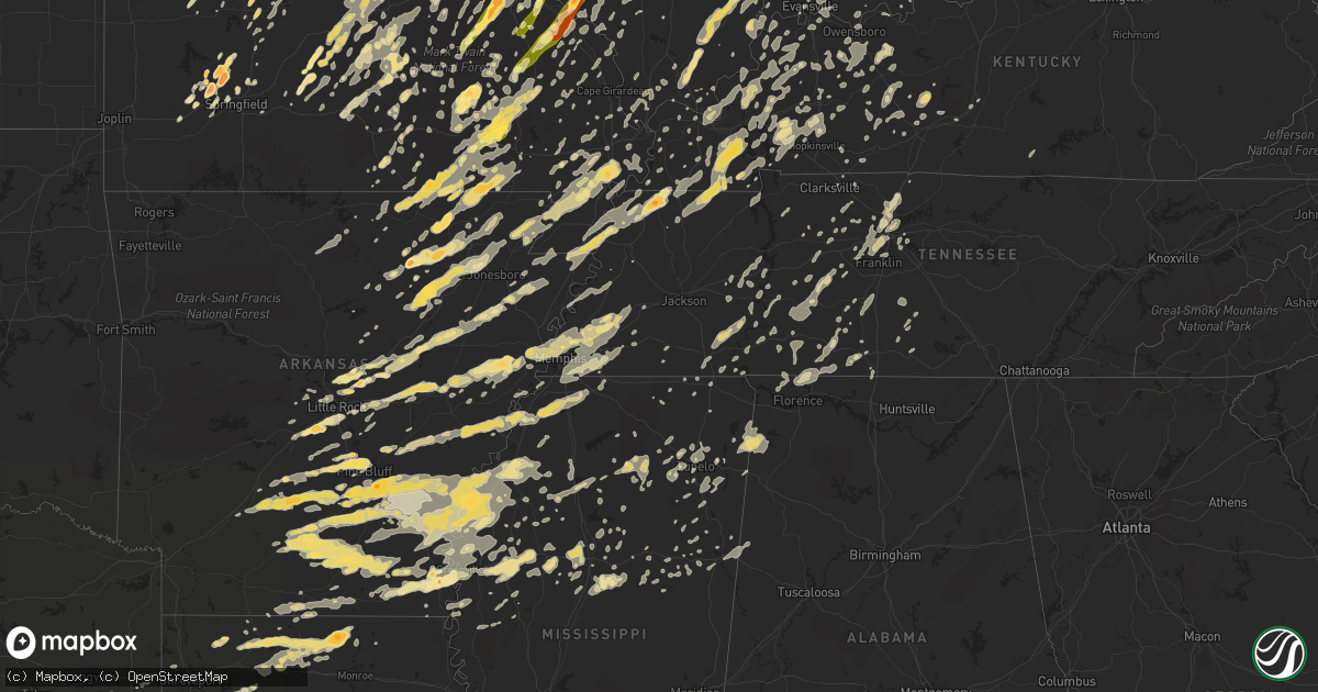
Hail Map in Kentucky on May 25, 2011
Get this storm
May 25 map
$229
one time, instant access
Download today. No call, no setup
Keep the $229
Bought the map and want the full workflow? Apply the entire $229 to a subscription within 7 days. None of it is wasted.
Every map, not just this one
This buys you this map. Subscription and you get every map we run, in the markets you choose from a few cities to whole states to nationwide. Plus real-time alerts the moment a storm fires.
Contact data
Name, contact info, occupancy, even credit band for addresses in the footprint. You go from where it hit to who to call.
Become the source they trust
Unlimited branding weather history reports on demand. You already have the documented answer ready for the property owner, and you are the one who showed up with it.
Property data and RoofTrace estimates
Pull up any address you have got, its value and the exact code rules for that jurisdiction, straight from One Click Code. Then RoofTrace estimates the squares, pitch, and roof value, priced the way you price.
Storm reports in Kentucky
Kentucky
| Date | Description |
|---|---|
| 05/25/20116:55 PM CDT | Damage survey revealed an ef2 tornado with a 17 mile long path from pulaski...to massac...to johnson...to pope county. See public information statement for details. |
| 05/25/20113:23 AM CDT | Tree down on grannys branch road. |
| 05/25/20113:17 AM CDT | Tree down on state route 638. |
| 05/25/20112:58 AM CDT | Tree down on east highway 577. |
| 05/25/20112:47 AM CDT | A power line was blown down on laurel lake road in keavy. |
| 05/25/20112:45 AM CDT | 3 large trees down across hwy 1227. |
| 05/25/20112:43 AM CDT | Tree blown down outside of the jail in london. |
| 05/25/20112:21 AM CDT | Power outages were reported in mount victory. |
| 05/25/20112:18 AM CDT | Trees down in a persons yard. |
| 05/25/20112:15 AM CDT | Power outages were reported in burnside. |
| 05/25/20112:05 AM CDT | Limb broken off of a walnut tree and blow down the street. Also had pea sized hail almost covering the ground. |
| 05/25/20112:04 AM CDT | Trees were blown down on hwy 80 just west of somerset. |
| 05/25/20111:55 AM CDT | Trees were blown down onto a trailer home on evelyn avenue in monticello. |
| 05/25/20111:50 AM CDT | A tree was blown down onto a house along hwy 1546 in murl. |
| 05/25/20111:45 AM CDT | Barn blown into ky 200 near hwy 167. |
| 05/25/201112:09 AM CDT | Several trees downed across green county...including one in greensburg. |
| 05/24/201111:44 PM CDT | Trees down in bradford area. |
| 05/24/201111:42 PM CDT | Several trees down |
| 05/24/201111:29 PM CDT | Extensive tree damage in alexandria including numerous trees snapped and uprooted. Minor roof damage to a few structures. Power poles snapped. |
| 05/24/201111:28 PM CDT | Three foot diameter trees down across the area. Power out in alexandria with lines down. Road signs blown down. Ky hwy 915 blocked by fallen trees. |
| 05/24/201111:27 PM CDT | Large branches broken |
| 05/24/201111:20 PM CDT | Trained spotter reported winds in excess of 60 mph near bowling green junior high |
| 05/24/201111:16 PM CDT | Large branches broken |
| 05/24/201111:15 PM CDT | Gusts to 60 mph at hooper station road four miles southeast of shelbyville. |
| 05/24/201111:15 PM CDT | Large branches broken. Time estimated from radar. |
| 05/24/201111:13 PM CDT | A local report indicates 58 MPH wind near BOWLING GREEN |
| 05/24/201111:12 PM CDT | Barn and trees down |
| 05/24/201111:10 PM CDT | An apartment building was damaged in bowling green with part of the roof torn off...shingles in the courtyard...and shutters ripped off of brick siding. |
| 05/24/201111:10 PM CDT | Large branches broken |
| 05/24/201111:07 PM CDT | Downed trees blocking roads across simpson county |
| 05/24/201111:03 PM CDT | Many hardwood trees down along and near bogle road |
| 05/24/201111:00 PM CDT | Several trees down and debris from a roof at the intersection of hwy 23 and hwy 621 |
| 05/24/201110:55 PM CDT | Power outage also |
| 05/24/201110:46 PM CDT | Trees and power lines down throughout logan county |
| 05/24/201110:40 PM CDT | Measured at the shelby county mesonet site. |
| 05/24/201110:36 PM CDT | A local report indicates 65 MPH wind near ANCHORAGE |
| 05/24/201110:30 PM CDT | 60 to 70 mph wind estimated in douglass hills |
| 05/24/201110:25 PM CDT | A local report indicates 60 MPH wind near PEMBROKE |
| 05/24/201110:20 PM CDT | Trees and power lines down |
| 05/24/201110:18 PM CDT | A local report indicates 59 MPH wind near 5 N OAK GROVE |
| 05/24/201110:18 PM CDT | Roof of one home blown off. |
| 05/24/201110:15 PM CDT | Report of trees and power lines down |
| 05/24/201110:09 PM CDT | Occurring on north side of town. |
| 05/24/201110:06 PM CDT | Measured at flaherty ham radio site. Time estimated based on radar passage of gust front. |
| 05/24/20119:50 PM CDT | Trees down blocking roadways. Power outages reported. Wind gusts with storm were measured at 56 mph. |
| 05/24/20119:50 PM CDT | A local report indicates 58 MPH wind near HARDINSBURG |
| 05/24/20119:47 PM CDT | Measured at higway 800 and the pennyrile parkway. |
| 05/24/20119:41 PM CDT | Tree on a home |
| 05/24/20119:40 PM CDT | Late report...part of roof off of linton methodist church and numerous trees down. |
| 05/24/20119:37 PM CDT | Reported by jackson purchase energy...over 6400 customers without power in 6 counties across the kentucky purchase area. |
| 05/24/20119:35 PM CDT | A local report indicates 60 MPH wind near 4 SW CADIZ |
| 05/24/20119:32 PM CDT | 8500 customers in calloway...marshall and graves have no power. |
| 05/24/20119:23 PM CDT | Trees and power lines down near the community. Winds estimated 60 mph associated with this storm. |
| 05/24/20119:17 PM CDT | Ef0 tornado occurred with wind speeds estimated at 85 mph. About a dozen trees were down and several tree tops snapped. One car was completely destroyed by a large tree |
| 05/24/20119:17 PM CDT | A local report indicates 70 MPH wind near HAWESVILLE |
| 05/24/20119:10 PM CDT | Microburst occurred with wind speeds estimated at around 100 mph. There was light to moderate damage to about 30 homes...mainly due to fallen trees. One home destroyed |
| 05/24/20119:09 PM CDT | 10 power poles blown down along hwy 141. |
| 05/24/20119:06 PM CDT | Occurred along pleasant valley road. |
| 05/24/20119:02 PM CDT | A local report indicates 60 MPH wind near EARLINGTON |
| 05/24/20119:01 PM CDT | Trees down near apollo high school. |
| 05/24/20118:55 PM CDT | A local report indicates 60 MPH wind near 2 SE PRINCETON |
| 05/24/20118:54 PM CDT | A local report indicates 61 MPH wind near OWENSBORO |
| 05/24/20118:52 PM CDT | Measured along interstate 64 near mile marker 56. |
| 05/24/20118:46 PM CDT | A local report indicates 60 MPH wind near 10 W OWENSBORO |
| 05/24/20118:45 PM CDT | On hwy 147 or wrightsburg rd and bd luck road...4 chicken houses were destroyed and a total loss. These chicken houses were approximately 50 ft wide and 500 to 550 ft l |
| 05/24/20118:45 PM CDT | A local report indicates 61 MPH wind near 5 NW CALHOUN |
| 05/24/20118:44 PM CDT | Numerous trees down. |
| 05/24/20118:34 PM CDT | 10 power poles blown down along hwy 141. |
| 05/24/20118:29 PM CDT | Large tree fell across mobile home. |
| 05/24/20118:19 PM CDT | Ef0 tornado. 2.5 miles northwest of kirksey ky or 10 miles northwest of murray ky. Peak wind 70 mph. Ave. Path width 50 yards. Path length 0.25 miles. Several dozen...m |
| 05/24/20118:17 PM CDT | A local report indicates 60 MPH wind near BREWERS |
| 05/24/20118:04 PM CDT | A local report indicates 69 MPH wind near CALVERT CITY |
| 05/24/20117:56 PM CDT | Wind gusts estimated. Event occurred at intersection of hwys 62 and 95. |
| 05/24/20117:55 PM CDT | A local report indicates 60 MPH wind near UNIONTOWN |
| 05/24/20117:52 PM CDT | A local report indicates 70 MPH wind near PALMA |
| 05/24/20117:45 PM CDT | Late report...3 to 3.5 inch diameter tree branches ripped off of trees. |
| 05/24/20117:43 PM CDT | A local report indicates 1.00 inch wind near HICKMAN |
| 05/24/20117:34 PM CDT | Wind gusts estimated 70 to 80 mph in the farley area. |
| 05/24/20117:25 PM CDT | Reported at barkley regional airport. |
| 05/24/20117:13 PM CDT | A local report indicates 62 MPH wind near WEST PADUCAH |
| 05/24/20117:10 PM CDT | Trees and limbs down along interstate 24 near mile marker 21. |
All States Impacted by Hail Map on May 25, 2011
Cities Impacted by Hail Map on May 25, 2011
- Brighton, IL
- Climax Springs, MO
- Edwards, MO
- Trafalgar, IN
- Nineveh, IN
- Nashville, IN
- Morgantown, IN
- Obion, TN
- South Fulton, TN
- Rives, TN
- Union City, TN
- Fulton, KY
- Hornbeak, TN
- Troy, TN
- Coushatta, LA
- Dawson Springs, KY
- Hamburg, AR
- Bernie, MO
- Dexter, MO
- Vandalia, IL
- Kampsville, IL
- Hartford City, IN
- Muncie, IN
- Upland, IN
- Francesville, IN
- Spencerville, IN
- Fort Wayne, IN
- Grabill, IN
- Harlan, IN
- Woodburn, IN
- New Haven, IN
- Tunica, MS
- Meta, MO
- Dixon, MO
- Argyle, MO
- Vienna, MO
- Brinktown, MO
- Connersville, IN
- Centerville, IN
- Cord, AR
- Brownsville, TN
- Colfax, LA
- Troy, MO
- Moscow Mills, MO
- Foristell, MO
- Wentzville, MO
- Old Monroe, MO
- Harrisburg, IL
- Noble, IL
- Florence, AL
- Iron City, TN
- Killen, AL
- Jena, LA
- Piedmont, MO
- Rison, AR
- Cortland, OH
- Spring Valley, OH
- Xenia, OH
- Dayton, OH
- Bellbrook, OH
- Gore Springs, MS
- Duck Hill, MS
- Atlanta, IL
- Wapella, IL
- Clinton, IL
- Waynesville, IL
- McLean, IL
- Kenney, IL
- Heyworth, IL
- Rittman, OH
- Wadsworth, OH
- Doylestown, OH
- Cotton Valley, LA
- Benton, LA
- Romance, AR
- Rose Bud, AR
- Sikeston, MO
- Essex, MO
- Bell City, MO
- Vanduser, MO
- Bloomfield, MO
- Creston, OH
- Seville, OH
- Sidon, MS
- Greenwood, MS
- Brookville, IN
- Oxford, OH
- Cedar Grove, IN
- Doniphan, MO
- Strawberry, AR
- Poughkeepsie, AR
- Batesville, AR
- Alicia, AR
- Smithville, AR
- Sulphur Rock, AR
- Cave City, AR
- Walnut Ridge, AR
- Hoxie, AR
- Portia, AR
- Black Rock, AR
- Lynn, AR
- Powhatan, AR
- Bloomington, IN
- Lovington, IL
- Baring, MO
- Ashland, OH
- New London, OH
- Nova, OH
- Sullivan, OH
- Greenville, MS
- Benoit, MS
- Oak Harbor, OH
- Port Clinton, OH
- Piasa, IL
- Shipman, IL
- Medora, IL
- Griffithville, AR
- Searcy, AR
- Cambridge Springs, PA
- Union City, PA
- Thornton, AR
- Bearden, AR
- Avon, OH
- Olmsted Falls, OH
- North Olmsted, OH
- North Ridgeville, OH
- Westlake, OH
- Shelby, MS
- Clarksdale, MS
- Mexico, MO
- Miller City, IL
- Charleston, MO
- Cairo, IL
- Osceola, MO
- Lowry City, MO
- West Plains, MO
- Attica, OH
- Bloomville, OH
- Tiffin, OH
- Republic, OH
- Cole Camp, MO
- Oakland, MS
- Water Valley, MS
- Bauxite, AR
- Bryant, AR
- New Riegel, OH
- Weimar, TX
- Schulenburg, TX
- Deville, LA
- Pineville, LA
- Ball, LA
- Center Point, LA
- Marksville, LA
- Effie, LA
- South Bend, IN
- Merigold, MS
- Beulah, MS
- Cleveland, MS
- Belleville, IL
- Freeburg, IL
- Tamms, IL
- Thebes, IL
- Olive Branch, IL
- Villa Ridge, IL
- Pulaski, IL
- Mounds, IL
- Bernice, LA
- Morrisville, MO
- Brighton, MO
- Willard, MO
- Walnut Grove, MO
- Waynesville, MO
- Lebanon, MO
- Falcon, MO
- Laquey, MO
- Ledbetter, TX
- Giddings, TX
- West Lafayette, IN
- Ellington, MO
- Gosport, IN
- Corunna, IN
- Kendallville, IN
- Avilla, IN
- Jacksonville, AR
- Converse, LA
- Pine Bluff, AR
- Malvern, AR
- Sherrill, AR
- Leola, AR
- Jefferson, AR
- Grapevine, AR
- Sheridan, AR
- Arkadelphia, AR
- White Hall, AR
- Carthage, AR
- Payne, OH
- Antwerp, OH
- Cascilla, MS
- Arnold, MO
- Imperial, MO
- Marysville, OH
- Van Buren, MO
- Edinburg, IL
- Barry, IL
- New Canton, IL
- Oakdale, IL
- Nashville, IL
- Guthrie, KY
- Trenton, KY
- Crowley, LA
- Ganado, TX
- Markle, IN
- Bluffton, IN
- Uniondale, IN
- Roanoke, IN
- Huntington, IN
- Ossian, IN
- Salem, IL
- Iuka, IL
- Oil Trough, AR
- Martinsville, IL
- Marshall, IL
- Rosedale, IN
- Mammoth Spring, AR
- Camp, AR
- Glencoe, AR
- Couch, MO
- Alton, MO
- Ravenden, AR
- Myrtle, MO
- Osage Beach, MO
- Sunrise Beach, MO
- Newport, AR
- Newark, AR
- Conroe, TX
- Cleveland, TX
- Lexa, AR
- Poplar Grove, AR
- Hornbeck, LA
- Milroy, IN
- Rushville, IN
- Greensburg, IN
- Napoleon, MO
- Bates City, MO
- Oak Grove, MO
- Biscoe, AR
- Des Arc, AR
- Stover, MO
- Smithton, MO
- Warsaw, MO
- Florence, MO
- Lincoln, MO
- Mora, MO
- Ashkum, IL
- Castalia, OH
- Vickery, OH
- Sandusky, OH
- Huron, OH
- Old Fort, OH
- Clyde, OH
- Milan, OH
- Fremont, OH
- Monroeville, OH
- Green Springs, OH
- Bellevue, OH
- Berlin Heights, OH
- Grady, AR
- Bloomsdale, MO
- Wakeman, OH
- Vermilion, OH
- Paoli, IN
- French Lick, IN
- Morral, OH
- Marion, OH
- Sainte Genevieve, MO
- Rochester, IL
- Rocheport, MO
- Mulberry Grove, IL
- Ramsey, IL
- Beecher, IL
- Grovespring, MO
- Bloomfield, IN
- Shelbyville, TX
- Tipton, IN
- Odessa, MO
- Lone Jack, MO
- Vulcan, MO
- Montgomery, IN
- Plainville, IN
- Loogootee, IN
- Elnora, IN
- Washington, IN
- Owensburg, IN
- Crane, IN
- Odon, IN
- Springville, IN
- Worthington, IN
- Millington, TN
- Wabash, IN
- Maynard, AR
- Oxly, MO
- Okeana, OH
- Anahuac, TX
- Winnie, TX
- Robertsville, MO
- Parker City, IN
- Albany, IN
- Gibsonburg, OH
- Luckey, OH
- Woodville, OH
- Pemberville, OH
- Genoa, OH
- Ridgely, TN
- Mascoutah, IL
- Pawnee, IL
- Mount Blanchard, OH
- New Lebanon, OH
- Duke, MO
- Newburg, MO
- Devils Elbow, MO
- Palacios, TX
- Blessing, TX
- Columbia City, IN
- Spencer, IN
- Solsberry, IN
- Castor, LA
- New Madrid, MO
- Hiram, OH
- Jonesburg, MO
- Warrenton, MO
- Raymondville, MO
- Frankfort, IN
- Cutler, IN
- Russiaville, IN
- Woodville, MS
- Henning, TN
- Ellettsville, IN
- Delphi, IN
- Brookston, IN
- Brookville, OH
- Cedarville, OH
- Wilberforce, OH
- Alpha, OH
- Eolia, MO
- Silex, MO
- Fulton, MO
- Roundhill, KY
- Brownsville, KY
- Sweeden, KY
- Ringgold, LA
- Jamestown, LA
- Goldonna, LA
- Saline, LA
- Ashland, LA
- Hall Summit, LA
- San Augustine, TX
- Ravenna, OH
- Williams, IN
- Matthews, MO
- Lilbourn, MO
- Mansfield, LA
- Pelican, LA
- Natchitoches, LA
- Natchez, LA
- Robeline, LA
- Pleasant Hill, LA
- Noble, LA
- Marthaville, LA
- Saint Louis, MO
- Warren, OH
- Newton Falls, OH
- Leavittsburg, OH
- Niles, OH
- Pevely, MO
- Festus, MO
- Hillsboro, MO
- Milmine, IL
- Monticello, IL
- Belzoni, MS
- Collierville, TN
- Germantown, TN
- Rossville, TN
- Eads, TN
- Memphis, TN
- Cordova, TN
- Alhambra, IL
- Marine, IL
- Westphalia, MO
- Saint Thomas, MO
- Billings, MO
- Republic, MO
- Bastrop, TX
- Paige, TX
- Garwood, TX
- Louise, TX
- Hallettsville, TX
- Woodstock, OH
- Milford Center, OH
- North Lewisburg, OH
- Ethel, MS
- Vaiden, MS
- Kilmichael, MS
- Plain City, OH
- Lizton, IN
- Jamestown, IN
- Minter City, MS
- Belleview, MO
- Cadet, MO
- Mineral Point, MO
- Bonne Terre, MO
- Belgrade, MO
- De Soto, MO
- Potosi, MO
- Blackwell, MO
- Bixby, MO
- Cabot, AR
- Elyria, OH
- Pope, MS
- Enid, MS
- Batesville, MS
- Courtland, MS
- Bowling Green, IN
- Coal City, IN
- Centerpoint, IN
- Clay City, IN
- Bentley, LA
- Dry Prong, LA
- Cloutierville, LA
- Montgomery, LA
- Shelbyville, IN
- Indianapolis, IN
- Greenwood, IN
- New Palestine, IN
- Boggstown, IN
- Whiteland, IN
- Franklin, IN
- Needham, IN
- Fairland, IN
- Bargersville, IN
- Martinsville, IN
- Lyon, MS
- Coahoma, MS
- Springfield, MO
- Chrisman, IL
- South Charleston, OH
- South Solon, OH
- Calhoun, MO
- Windsor, MO
- West Alexandria, OH
- Farmersville, OH
- Vienna, IL
- Stonefort, IL
- Simpson, IL
- Ozark, IL
- Grantsburg, IL
- Mayfield, KY
- West College Corner, IN
- Louisville, MS
- Ingraham, IL
- Dieterich, IL
- Newton, IL
- Clifford, IN
- Flat Rock, IN
- Hope, IN
- Columbus, IN
- Tatum, TX
- Henderson, TX
- Beckville, TX
- Chester, IL
- Steeleville, IL
- Kenton, OH
- Columbus, TX
- Ash Grove, MO
- Lakeview, OH
- Perryville, MO
- Mulberry, IN
- Greenville, OH
- Gettysburg, OH
- Bradford, OH
- Nashville, TN
- Kokomo, IN
- Kempton, IN
- Sharpsville, IN
- Portland, AR
- Montrose, AR
- Lake Village, AR
- Viburnum, MO
- Steelville, MO
- Marion, IN
- Itta Bena, MS
- Schlater, MS
- Ecru, MS
- New Albany, MS
- Grandin, MO
- Fairdealing, MO
- Stockdale, TX
- Nixon, TX
- Bucyrus, OH
- Fayette, AL
- Berry, AL
- Bankston, AL
- Centerburg, OH
- Sunbury, OH
- Marengo, OH
- Somerville, OH
- West Harrison, IN
- Laurel, IN
- Germantown, OH
- Metamora, IN
- Hamilton, OH
- Bath, IN
- Franklin, OH
- Middletown, OH
- Miamisburg, OH
- Sunman, IN
- College Corner, OH
- Trenton, OH
- Liberty, IN
- Scott, AR
- Jasper, AL
- Houston, MO
- Cabool, MO
- Solo, MO
- Mountain Grove, MO
- Edna, TX
- Sheridan, TX
- Madison, IL
- Fenton, MO
- Chesterfield, MO
- Ballwin, MO
- Valley Park, MO
- Granite City, IL
- Venice, IL
- Decaturville, TN
- Starkville, MS
- Beebe, AR
- Danville, IL
- Oakwood, IL
- Bronson, TX
- Hemphill, TX
- Milam, TX
- Franklin, TN
- Lillie, LA
- Spearsville, LA
- League City, TX
- New Haven, IL
- Ridgway, IL
- Cotton Plant, AR
- Hazen, AR
- Carlisle, AR
- Laddonia, MO
- Greencastle, IN
- Placedo, TX
- Bloomington, TX
- Jadwin, MO
- Salem, MO
- Mitchell, IN
- Greenfield, IN
- Owensville, IN
- Velpen, IN
- Norman, IN
- Stinesville, IN
- Avoca, IN
- Shoals, IN
- Princeton, IN
- Jasper, IN
- Patoka, IN
- Heltonville, IN
- Oolitic, IN
- Hartsville, IN
- Saint Paul, IN
- Edinburgh, IN
- Fountaintown, IN
- Mooresville, IN
- Freedom, IN
- Lyons, IN
- Bedford, IN
- Manilla, IN
- Oldenburg, IN
- Wheatland, IN
- Newberry, IN
- Switz City, IN
- Freetown, IN
- Huntingburg, IN
- Waldron, IN
- Monroe City, IN
- Paragon, IN
- Taylorsville, IN
- Hazleton, IN
- Vincennes, IN
- Decker, IN
- Seymour, IN
- Batesville, IN
- Winslow, IN
- Okolona, MS
- Shannon, MS
- Almyra, AR
- Crocketts Bluff, AR
- Stuttgart, AR
- Humphrey, AR
- Casscoe, AR
- Eminence, MO
- Metropolis, IL
- Niangua, MO
- Hartville, MO
- Evansville, IN
- Cisco, IL
- Cerro Gordo, IL
- Otterbein, IN
- Derby, IN
- Liberty, TX
- Licking, MO
- Beulah, MO
- Edgar Springs, MO
- Success, MO
- Roby, MO
- Seymour, IL
- Weldon, IL
- Mansfield, IL
- Champaign, IL
- Sadorus, IL
- De Land, IL
- Rantoul, IL
- Thomasboro, IL
- Bondville, IL
- Fisher, IL
- White Heath, IL
- Dewey, IL
- Ivesdale, IL
- Urbana, IL
- Savoy, IL
- Mahomet, IL
- Tolono, IL
- Windham, OH
- Mantua, OH
- Garrettsville, OH
- Lohman, MO
- Russellville, MO
- Rocky Mount, MO
- Gravois Mills, MO
- Olean, MO
- Centertown, MO
- Latham, MO
- Jefferson City, MO
- California, MO
- Versailles, MO
- Eldon, MO
- Barnett, MO
- Straughn, IN
- New Castle, IN
- New Washington, OH
- Mill Spring, MO
- Ellsinore, MO
- Williamsville, MO
- Pocahontas, IL
- Breese, IL
- Pleasant Hill, IL
- Annada, MO
- Hawk Point, MO
- Bowling Green, MO
- Elsberry, MO
- Pearl, IL
- Middletown, MO
- Nebo, IL
- Hamburg, IL
- Clarksville, MO
- Truxton, MO
- Yuma, TN
- Lexington, TN
- Wildersville, TN
- Lisbon, LA
- Farmerville, LA
- Minden, LA
- Homer, LA
- Dubach, LA
- Marion, LA
- Lolita, TX
- Somerville, TN
- Morristown, IN
- Carthage, IN
- Arlington, IN
- Oxford, MS
- Osgood, IN
- Westfield, IN
- Hillview, IL
- Browns, IL
- Mount Carmel, IL
- Yorktown, TX
- Foley, MO
- Ruleville, MS
- Spring Valley, IL
- Granville, IL
- Atlanta, IN
- Montgomery City, MO
- Wellsville, MO
- Bellflower, MO
- Texico, IL
- Mount Vernon, IL
- Walnut Hill, IL
- Dix, IL
- Kell, IL
- Seymour, MO
- Linden, TN
- Berger, MO
- Gas City, IN
- Fowlerton, IN
- Summitville, IN
- Fairmount, IN
- Jonesboro, IN
- Charleston, MS
- Lovejoy, IL
- Culver, IN
- Syracuse, IN
- Milford, IN
- Windfall, IN
- Elwood, IN
- Romney, IN
- Crawfordsville, IN
- Lafayette, IN
- New Richmond, IN
- Clarks Hill, IN
- Linden, IN
- Dickson, TN
- Widener, AR
- Wynne, AR
- Colt, AR
- Parkin, AR
- Heth, AR
- Palestine, AR
- Earle, AR
- Forrest City, AR
- Eddyville, KY
- Van Buren, IN
- Piqua, OH
- Houston, OH
- Hinckley, OH
- Upper Sandusky, OH
- Nevada, OH
- Findlay, OH
- Middletown, IN
- Shirley, IN
- Gonzales, TX
- Shiner, TX
- Urbana, OH
- Springfield, OH
- Tremont City, OH
- Bluffton, OH
- Defiance, MO
- O'Fallon, MO
- Lake Saint Louis, MO
- Watson, AR
- Olmstead, KY
- Fort Leonard Wood, MO
- Vichy, MO
- Freeburg, MO
- Richland, MO
- Belle, MO
- Jerome, MO
- Crocker, MO
- Rolla, MO
- Saint Robert, MO
- Linn, MO
- Brazil, IN
- Whites Creek, TN
- Ironton, MO
- Annapolis, MO
- Morocco, IN
- Lima, OH
- Springboro, OH
- Paris, IL
- Little Rock, AR
- Roland, AR
- Ottawa, OH
- Leipsic, OH
- Cross Timbers, MO
- Sycamore, OH
- Mechanicsburg, OH
- Horseshoe Bend, AR
- Carey, OH
- Demotte, IN
- Rossville, IN
- Bringhurst, IN
- Reynolds, IN
- Chalmers, IN
- Monticello, IN
- Zwolle, LA
- Blytheville, AR
- Caruthersville, MO
- Steele, MO
- Cooter, MO
- Florien, LA
- Leesville, LA
- Boyce, LA
- Elmer, LA
- Lena, LA
- Flatwoods, LA
- Mora, LA
- Monterey, LA
- Alexandria, LA
- Provencal, LA
- Acme, LA
- Pollock, LA
- Jonesville, LA
- Fortuna, MO
- East Liberty, OH
- Tutwiler, MS
- Lambert, MS
- Williamstown, OH
- Forest, OH
- Dunkirk, OH
- Arlington, OH
- Waynetown, IN
- Crete, IL
- Cleveland, OH
- Independence, OH
- Elkland, MO
- Gillett, AR
- Tichnor, AR
- De Witt, AR
- Gould, AR
- Yorktown, AR
- Star City, AR
- Beaumont, TX
- Plainfield, IN
- Clayton, IN
- Moreauville, LA
- Danville, IN
- Coatesville, IN
- Benton, KY
- Crofton, KY
- Russellville, AL
- Pontotoc, MS
- Alexander, AR
- Ravenden Springs, AR
- Imboden, AR
- Arlington, KY
- Everton, MO
- Prospect, OH
- Wheatley, AR
- Goodwin, AR
- Hume, IL
- Brentwood, TN
- Spiceland, IN
- Knightstown, IN
- Hampton, AR
- Antioch, TN
- Van Wert, OH
- Mentone, IN
- Claypool, IN
- Burket, IN
- Counce, TN
- Shiloh, TN
- Moscow, TX
- Mabelvale, AR
- Benton, AR
- Naylor, MO
- Edinboro, PA
- Saegertown, PA
- Venango, PA
- Little York, IL
- Poplar Bluff, MO
- Patterson, MO
- Arbela, MO
- Midfield, TX
- Bay City, TX
- Bolivar, MO
- Marshall, IN
- Bloomingdale, IN
- Montezuma, IN
- New Waverly, TX
- Huntsville, TX
- Thaxton, MS
- Randolph, MS
- Paris, MS
- Houlka, MS
- Andrews, IN
- Pasadena, TX
- Adamsville, TN
- Milledgeville, TN
- Morris Chapel, TN
- Bethel Springs, TN
- Sardis, TN
- Carlinville, IL
- Gillespie, IL
- Greenville, MO
- Marquand, MO
- Clubb, MO
- Silva, MO
- Crumrod, AR
- Duncan, MS
- Alligator, MS
- Addieville, IL
- Richmond, IN
- Amo, IN
- Eaton, OH
- Dumas, AR
- Wilmar, AR
- Snow Lake, AR
- McGehee, AR
- Tillar, AR
- Kingsland, AR
- Mellwood, AR
- Fordyce, AR
- Gunnison, MS
- New Edinburg, AR
- Monticello, AR
- Rosedale, MS
- Pickens, AR
- Rohwer, AR
- Mound Bayou, MS
- Winchester, AR
- Portageville, MO
- Altheimer, AR
- Wabbaseka, AR
- Miller, MO
- Creve Coeur, IL
- Pekin, IL
- East Peoria, IL
- Evansville, IL
- Modoc, IL
- Providence, KY
- Dixon, KY
- Coffeeville, MS
- Redfield, AR
- Hensley, AR
- Nokomis, IL
- Grovertown, IN
- Knox, IN
- Columbus Grove, OH
- Cecil, OH
- Paulding, OH
- Lakewood, IL
- Shelbyville, IL
- Strasburg, IL
- Buffalo, IL
- Eldorado, OH
- New Paris, OH
- Marthasville, MO
- Hopkinsville, KY
- Weiner, AR
- Fisher, AR
- Crenshaw, MS
- Sledge, MS
- Venedocia, OH
- Ada, OH
- Vanlue, OH
- Wharton, OH
- Dola, OH
- Arcanum, OH
- Tuscumbia, AL
- Parma, MO
- Bremen, AL
- Saint Mary, MO
- Farmington, MO
- Fredericktown, MO
- Pinckneyville, IL
- Tilden, IL
- Ellis Grove, IL
- Baldwin, IL
- Marissa, IL
- Sparta, IL
- Coulterville, IL
- Walsh, IL
- Hannibal, MO
- Monroe City, MO
- Palmyra, MO
- Center, MO
- Perry, MO
- Shreveport, LA
- Yoakum, TX
- Union Hill, IL
- Herscher, IL
- Buckingham, IL
- Bonfield, IL
- Vina, AL
- Goliad, TX
- Preston, MO
- Hermitage, MO
- Culleoka, TN
- Columbia, TN
- Spring Hill, TN
- Wilson, LA
- Clinton, LA
- Jetson, KY
- Caneyville, KY
- Shelby, OH
- Mansfield, OH
- Shiloh, OH
- Cuba, MO
- Hartville, OH
- Akron, OH
- Kent, OH
- Clinton, OH
- Canal Fulton, OH
- Massillon, OH
- Rootstown, OH
- Uniontown, OH
- Atwater, OH
- Alliance, OH
- Mogadore, OH
- North Canton, OH
- Boss, MO
- Roach, MO
- Camdenton, MO
- Waggoner, IL
- Divernon, IL
- Girard, IL
- Farmersville, IL
- Harvel, IL
- Morrisonville, IL
- Virden, IL
- Mechanicsburg, IL
- Millstadt, IL
- Palmyra, IL
- High Hill, MO
- Leighton, AL
- Splendora, TX
- Hankamer, TX
- Bedias, TX
- Dayton, TX
- Willis, TX
- Devers, TX
- Norwalk, OH
- Collins, OH
- New Carlisle, OH
- Fostoria, OH
- Teutopolis, IL
- Winona, MO
- Redford, MO
- Plato, MO
- Marianna, AR
- North Baltimore, OH
- Cygnet, OH
- Jerry City, OH
- West Terre Haute, IN
- Terre Haute, IN
- Dennison, IL
- Navasota, TX
- Anderson, TX
- Xenia, IL
- Kinmundy, IL
- Hazel, KY
- Murray, KY
- Clinton, IN
- Hillsdale, IN
- Vermilion, IL
- Arcola, IL
- Humboldt, IL
- Tuscola, IL
- Pesotum, IL
- Arthur, IL
- Veedersburg, IN
- Kingman, IN
- Hillsboro, IN
- Swifton, AR
- Churubusco, IN
- Yoder, IN
- Arcola, IN
- South Whitley, IN
- Cabery, IL
- Kempton, IL
- Burton, TX
- Clinton, MO
- Peace Valley, MO
- Birch Tree, MO
- Roachdale, IN
- Pulaski, TN
- Gideon, MO
- Ward, AR
- Salem, KY
- Warren, IN
- Greentown, IN
- Swayzee, IN
- Sheridan, IN
- Tallula, IL
- New Madison, OH
- West Manchester, OH
- Memphis, MO
- Findlay, IL
- Windsor, IL
- Tower Hill, IL
- Cowden, IL
- Gardner, IL
- Dwight, IL
- Athens, LA
- Simsboro, LA
- Arcadia, LA
- Downsville, LA
- Ruston, LA
- Gibsland, LA
- Arcadia, OH
- Alvada, OH
- Risingsun, OH
- Rawson, OH
- Van Buren, OH
- Kansas, OH
- Bloomdale, OH
- McComb, OH
- Lonoke, AR
- Madison, AR
- Brinkley, AR
- Crawfordsville, AR
- Anacoco, LA
- Many, LA
- Sherwood, AR
- Kansas City, MO
- Pocahontas, AR
- Hardy, AR
- Lodi, MO
- Success, AR
- Harviell, MO
- Fremont, MO
- Thayer, MO
- Neelyville, MO
- Warm Springs, AR
- Gatewood, MO
- Price, TX
- Cave City, KY
- Horse Cave, KY
- Grand Chain, IL
- Stilesville, IN
- Franklin, AR
- Melbourne, AR
- Grand Rivers, KY
- Marion, AR
- Westhoff, TX
- Royal Center, IN
- Salem, AR
- Lafe, AR
- Marmaduke, AR
- Paragould, AR
- Rector, AR
- Albion, PA
- Madison, TN
- El Dorado, AR
- Junction City, AR
- Belton, MO
- Grandview, MO
- Crestline, OH
- Oakland, IL
- Camargo, IL
- Hindsboro, IL
- Charleston, IL
- Newman, IL
- Carmine, TX
- Falkner, MS
- Tiplersville, MS
- Aberdeen, MS
- Centralia, IL
- Independence, MO
- Millport, AL
- Steens, MS
- Columbus, MS
- Ethelsville, AL
- Lamar, IN
- Chrisney, IN
- Sturdivant, MO
- Old Hickory, TN
- Chesterton, IN
- Ulman, MO
- Ora, IN
- Monterey, IN
- Clayton, IL
- Bois D Arc, MO
- Jersey, AR
- Hermitage, AR
- Fountain Hill, AR
- Drew, MS
- Banks, AR
- Camden, AR
- Harrell, AR
- Warren, AR
- Celina, OH
- Mendon, OH
- Rockford, OH
- Powell, OH
- Ostrander, OH
- Delaware, OH
- Tremont, MS
- Lenox, MO
- Amboy, IN
- Whitesville, KY
- Fordsville, KY
- Hartford, KY
- Reynolds Station, KY
- South Vienna, OH
- London, OH
- Fairborn, OH
- Yellow Springs, OH
- Norwood, MO
- Marvell, AR
- Linton, IN
- Jasonville, IN
- Portland, MO
- Rhineland, MO
- Ludlow Falls, OH
- Troy, OH
- West Milton, OH
- Waverly, IL
- Auburn, IL
- Coldwater, MS
- Hernando, MS
- Raleigh, IL
- Galatia, IL
- Clifton, TN
- Hermitage, TN
- Edgewood, IL
- Farina, IL
- Louisville, IL
- Austin, AR
- Vilonia, AR
- McRae, AR
- Garner, AR
- Leopold, MO
- Marble Hill, MO
- Wickliffe, KY
- Barlow, KY
- Butler, IN
- Greenway, AR
- Piggott, AR
- Bunceton, MO
- Newburgh, IN
- Boonville, IN
- Chandler, IN
- Woodlawn, IL
- Macks Creek, MO
- Ohio City, OH
- Decatur, IN
- Monroe, IN
- Willshire, OH
- England, AR
- Normal, IL
- Towanda, IL
- Gurdon, AR
- New London, MO
- Bardwell, KY
- Perrysville, IN
- Covington, IN
- Sorento, IL
- Greenville, IL
- Daleville, IN
- Yorktown, IN
- Sparkman, AR
- Vidalia, LA
- Owensboro, KY
- Selmer, TN
- Saltillo, TN
- Scotts Hill, TN
- Finger, TN
- Enville, TN
- Portland, IN
- Clay, KY
- Slaughters, KY
- West Salem, OH
- Polk, OH
- Pendleton, IN
- Rochester, KY
- Morgantown, KY
- Lewisville, IN
- Cambridge City, IN
- Harpster, OH
- Willow Springs, MO
- Liberty, IL
- Sullivan, MO
- Bourbon, MO
- Dittmer, MO
- Oconee, IL
- Pana, IL
- Hickman, KY
- Wright City, MO
- Fayetteville, TN
- Belknap, IL
- Brenham, TX
- Sims, IL
- Cisne, IL
- Inez, TX
- Victoria, TX
- Lostant, IL
- Hagerstown, IN
- Milton, IN
- Falmouth, IN
- Cuero, TX
- Olivehill, TN
- Bono, AR
- Cash, AR
- Bastrop, LA
- Belden, MS
- Tupelo, MS
- Linn Creek, MO
- West Helena, AR
- Helena, AR
- Loudonville, OH
- Goodlettsville, TN
- Cedar Hill, MO
- House Springs, MO
- West Farmington, OH
- Middlefield, OH
- Southington, OH
- Burton, OH
- Attica, IN
- Belmont, LA
- Santa Fe, MO
- Argenta, IL
- Beecher City, IL
- Urbana, MO
- Louisburg, MO
- Vienna, OH
- Aurora, OH
- Diamond, OH
- Fowler, OH
- Macedonia, OH
- Hudson, OH
- Brookfield, OH
- Twinsburg, OH
- Kinsman, OH
- Streetsboro, OH
- Burghill, OH
- Sherwood, OH
- Arcadia, MO
- Economy, IN
- Greens Fork, IN
- Williamsburg, IN
- Dudley, MO
- Kankakee, IL
- Trumann, AR
- Leasburg, MO
- Sterlington, LA
- Mount Vernon, OH
- Marion, KY
- La Fontaine, IN
- White House, TN
- Greenbrier, TN
- Washington, MO
- Mason, TN
- Covington, TN
- La Grange, TX
- Smithville, TX
- Tipton, MO
- Clarksburg, MO
- Piper City, IL
- Cullom, IL
- Forrest, IL
- Emington, IL
- Reddick, IL
- East Saint Louis, IL
- Columbia, IL
- Waterloo, IL
- Continental, OH
- Golden, MS
- Red Bay, AL
- Union City, OH
- Ansonia, OH
- Brunswick, OH
- Peninsula, OH
- Brecksville, OH
- Richfield, OH
- Northfield, OH
- Broadview Heights, OH
- Medina, OH
- North Royalton, OH
- Red Bud, IL
- New Athens, IL
- Benton Ridge, OH
- Bascom, OH
- Jenera, OH
- Mount Cory, OH
- Duck River, TN
- Centerville, TN
- Brighton, TN
- Arlington, TN
- Griffin, IN
- Harrod, OH
- Petersburg, TN
- Shelbyville, TN
- Mansfield, MO
- Saint Charles, MO
- Saint Peters, MO
- Golden Eagle, IL
- Brussels, IL
- Labadie, MO
- Augusta, MO
- Black Oak, AR
- Lake City, AR
- Lebanon, IN
- Bethalto, IL
- Bucyrus, MO
- Peru, IN
- Fieldon, IL
- Kane, IL
- Carrollton, IL
- Eldred, IL
- Summersville, MO
- Carlyle, IL
- Bartelso, IL
- Otwell, IN
- Neoga, IL
- Gays, IL
- Mattoon, IL
- Radnor, OH
- Lagrange, OH
- Petroleum, IN
- Leo, IN
- Alger, OH
- Burgoon, OH
- Keystone, IN
- Lorain, OH
- Albion, IN
- Converse, IN
- Monroeville, IN
- Haviland, OH
- Gomer, OH
- Hicksville, OH
- Whitestown, IN
- Zanesville, IN
- Belle Center, OH
- Huntertown, IN
- Middle Point, OH
- Green Camp, OH
- Latty, OH
- Larwill, IN
- Oakwood, OH
- Wren, OH
- Delphos, OH
- Mark Center, OH
- Uniopolis, OH
- Grafton, OH
- Bradner, OH
- Helena, OH
- Cairo, OH
- Hoagland, IN
- Geneva, IN
- Richwood, OH
- Vaughnsville, OH
- Oberlin, OH
- New Hampshire, OH
- Kelleys Island, OH
- Sheffield Lake, OH
- Lagro, IN
- Hamler, OH
- Pierceton, IN
- Ashley, OH
- Melrose, OH
- Ottoville, OH
- Waldo, OH
- Amherst, OH
- La Rue, OH
- Poneto, IN
- Defiance, OH
- Lakeside Marblehead, OH
- Bay Village, OH
- McCutchenville, OH
- Caledonia, OH
- Saint Marys, OH
- Middle Bass, OH
- Beaverdam, OH
- Spencerville, OH
- Montpelier, IN
- Lafayette, OH
- Deshler, OH
- Cloverdale, OH
- Scott, OH
- Kalida, OH
- McGuffey, OH
- Lewistown, OH
- Arcadia, IN
- Laotto, IN
- Liberty Center, IN
- Grover Hill, OH
- Elmore, OH
- Roundhead, OH
- New Bloomington, OH
- New Bavaria, OH
- Gaston, IN
- Lewis Center, OH
- Bettsville, OH
- Ney, OH
- Dublin, OH
- Bryant, IN
- Put In Bay, OH
- Pandora, OH
- Avon Lake, OH
- Holgate, OH
- Wapakoneta, OH
- Convoy, OH
- Urbana, IN
- Miller City, OH
- Fort Jennings, OH
- Botkins, OH
- Lindsey, OH
- Waynesfield, OH
- Berne, IN
- Pennville, IN
- Patton, MO
- Blue Springs, MS
- Warsaw, IN
- Portland, TN
- Saint Ann, MO
- Barnhart, MO
- Maryland Heights, MO
- East Alton, IL
- Hartford, IL
- Edwardsville, IL
- High Ridge, MO
- Dennis, MS
- Belmont, MS
- Manteno, IL
- Grant Park, IL
- Valmeyer, IL
- Rocky Ridge, OH
- Graytown, OH
- Camden, OH
- Winamac, IN
- Florissant, MO
- New Haven, MO
- Coila, MS
- Martinsburg, MO
- Williamsburg, MO
- Waynesboro, TN
- Lyles, TN
- Holly Grove, AR
- Battle Ground, IN
- Oran, MO
- Trinity, TX
- Oakhurst, TX
- Waltonville, IL
- Olive Branch, MS
- Grayville, IL
- Eupora, MS
- Cherryville, MO
- Valparaiso, IN
- La Crosse, IN
- Wanatah, IN
- Kouts, IN
- Cloverdale, IN
- Poland, IN
- Quincy, IN
- Murphysboro, IL
- Ava, IL
- Englewood, OH
- Clayton, OH
- Vandalia, OH
- Smiley, TX
- Bingham, IL
- Fillmore, IL
- Coffeen, IL
- Flat Rock, IL
- Mountain View, MO
- Vanleer, TN
- Erin, TN
- White Bluff, TN
- Refugio, TX
- Blanchard, LA
- Sunflower, MS
- Doddsville, MS
- Eureka, MO
- Blue Mound, IL
- Stonington, IL
- Pacific, MO
- Saint Albans, MO
- Wildwood, MO
- Proctor, AR
- O'Fallon, IL
- Scott Air Force Base, IL
- West Point, TX
- Fulton, MS
- Nettleton, MS
- Amory, MS
- Houston, TX
- La Porte, TX
- Deer Park, TX
- South Houston, TX
- Mount Olive, IL
- Walshville, IL
- Litchfield, IL
- New Douglas, IL
- Staunton, IL
- Livingston, IL
- Princeton, KY
- Cerulean, KY
- Cadiz, KY
- Spruce Pine, AL
- Davisville, MO
- Nunnelly, TN
- Ladoga, IN
- Mantachie, MS
- Zionsville, IN
- Atwood, IL
- New Berlin, IL
- West Point, MS
- Marshfield, MO
- Kimmell, IN
- Lawrenceville, IL
- Stanton, TN
- Atoka, TN
- Wingo, KY
- Harrisburg, AR
- La Salle, TX
- Bunker Hill, IL
- Losantville, IN
- Modoc, IN
- Caraway, AR
- Westpoint, IN
- Mount Vernon, MO
- Moro, IL
- Wood River, IL
- Cardington, OH
- Effingham, IL
- Wheeler, IL
- Trilla, IL
- Jewett, IL
- Toledo, IL
- Lerna, IL
- Sigel, IL
- Montrose, IL
- Double Springs, AL
- Houston, AL
- Hardin, KY
- Farmington, KY
- Kirksey, KY
- Almo, KY
- Gilbertsville, KY
- Tunas, MO
- Saint Francisville, LA
- Eldridge, AL
- Carbon Hill, AL
- Marshallville, OH
- Orrville, OH
- Oaktown, IN
- Edwardsport, IN
- Bicknell, IN
- Freelandville, IN
- Bruceville, IN
- Beaver Dam, KY
- Central City, KY
- Rockport, KY
- Oak Ridge, MO
- Altenburg, MO
- Jackson, MO
- Wheatland, MO
- Quincy, MO
- Norwood, LA
- Centreville, MS
- Isola, MS
- Leland, MS
- Inverness, MS
- Indianola, MS
- Moorhead, MS
- Nauvoo, AL
- Charlotte, TN
- Moweaqua, IL
- Sidney, AR
- Evening Shade, AR
- Winchester, IN
- Monmouth, IL
- Springboro, PA
- Du Quoin, IL
- Vergennes, IL
- Elkville, IL
- Auxvasse, MO
- Kingdom City, MO
- Avon, IN
- Rolling Fork, MS
- Louise, MS
- New Weston, OH
- Fort Recovery, OH
- Union City, IN
- Momence, IL
- Pembroke Township, IL
- Idaville, IN
- Apple Creek, OH
- Wooster, OH
- Roodhouse, IL
- Martinton, IL
- Donovan, IL
- Beaverville, IL
- Park Hills, MO
- Doe Run, MO
- Fayetteville, TX
- Bon Aqua, TN
- Finley, TN
- Dyersburg, TN
- Tiptonville, TN
- Hayti, MO
- Hebron, IN
- Lewisburg, OH
- Clarksville, TN
- Bowling Green, OH
- Perrysburg, OH
- Modesto, IL
- Calvert City, KY
- Heflin, LA
- Dubberly, LA
- Hazelwood, MO
- Cherry Valley, AR
- Jamestown, MO
- Tishomingo, MS
- Bloomington, IL
- French Camp, MS
- Galion, OH
- Calico Rock, AR
- Excello, MO
- Huntsville, MO
- Craigville, IN
- Madisonville, KY
- North Lawrence, OH
- Dalton, OH
- Smithville, OH
- Worden, IL
- Sidney, OH
- New Bloomfield, MO
- Cable, OH
- Malden, MO
- Campbell, MO
- Franklin, MO
- New Franklin, MO
- Bunker, MO
- Pine Village, IN
- Crown Point, IN
- Lowell, IN
- Cedar Lake, IN
- Kirkwood, IL
- Gerlaw, IL
- Hermann, MO
- Armstrong, MO
- Higbee, MO
- Fayette, MO
- Saint Henry, OH
- Maria Stein, OH
- Rossburg, OH
- Bremen, KY
- Bristolville, OH
- North Bloomfield, OH
- Farmdale, OH
- Prairie, MS
- Des Arc, MO
- Camden, IN
- Flora, IN
- Buck Creek, IN
- Mountain View, AR
- Locust Grove, AR
- Drasco, AR
- Winchester, IL
- Sedalia, MO
- Sumner, MS
- Green Ridge, MO
- Mccordsville, IN
- Pegram, TN
- Fairview, TN
- Lynn, IN
- Fountain City, IN
- West Memphis, AR
- Half Way, MO
- Elizabeth, AR
- Fredericktown, OH
- Butler, OH
- Enfield, IL
- Carmi, IL
- Norris City, IL
- Versailles, OH
- McLeansboro, IL
- Savannah, TN
- Bald Knob, AR
- Maroa, IL
- East Prairie, MO
- North Fairfield, OH
- Willard, OH
- Quincy, OH
- Conover, OH
- Ridge Farm, IL
- Russellville, KY
- Lewisburg, KY
- Villa Grove, IL
- Longview, IL
- Brookport, IL
- Witt, IL
- Hillsboro, IL
- Carbon, IN
- Island, KY
- Sacramento, KY
- Medora, IN
- Jackson, LA
- Sidney, IL
- Saint Joseph, IL
- Philo, IL
- North Manchester, IN
- Waverly, KY
- Saltillo, MS
- Sturgis, MS
- Waterloo, IN
- Auburn, IN
- Meredosia, IL
- Bluffs, IL
- West Frankfort, IL
- Philipp, MS
- Burlington, IN
- Burnettsville, IN
- Wingate, IN
- Richwoods, MO
- Lewisport, KY
- Hawesville, KY
- Eagle Lake, TX
- Sedgewickville, MO
- Shelburn, IN
- Sullivan, IN
- Conneaut, OH
- Bertrand, MO
- Ashland, IL
- Joelton, TN
- Ashland City, TN
- Mount Pleasant, TN
- Spencer, OH
- Percy, IL
- Rockwood, IL
- Lawrenceburg, TN
- Ethridge, TN
- Dunkirk, IN
- Beason, IL
- Chestnut, IL
- Carrier Mills, IL
- Broughton, IL
- Eldorado, IL
- Williford, AR
- Corinth, MS
- McCrory, AR
- O'Kean, AR
- Saffell, AR
- Peach Orchard, AR
- Corning, AR
- Knobel, AR
- Delaplaine, AR
- Heber Springs, AR
- Elizabethtown, IL
- Cave In Rock, IL
- McCarley, MS
- Winona, MS
- North Carrollton, MS
- Carrollton, MS
- Saint Jacob, IL
- Lebanon, IL
- Troy, IL
- Westfield, IL
- Kansas, IL
- Sullivan, IL
- Omaha, IL
- Shawneetown, IL
- Mount Vernon, IN
- Carthage, IL
- Strong, AR
- Huttig, AR
- Steedman, MO
- Assumption, IL
- Ullin, IL
- Cypress, IL
- Dongola, IL
- Mortons Gap, KY
- White Plains, KY
- Bellville, OH
- Hubbard, OH
- Greenwich, OH
- Irwin, OH
- Wyaconda, MO
- La Belle, MO
- Shaw, MS
- McEwen, TN
- Oakland, TX
- Matagorda, TX
- Ellinger, TX
- El Campo, TX
- Fair Grove, MO
- Selma, IN
- Mooreland, IN
- Petersburg, IL
- Bland, MO
- Thida, AR
- Tuckerman, AR
- Bradford, AR
- Union, MO
- Gillett, TX
- Perrysville, OH
- Lucas, OH
- McKean, PA
- Augusta, AR
- Monee, IL
- Peotone, IL
- Huggins, MO
- Rinard, IL
- Smithboro, IL
- Irving, IL
- Herrick, IL
- Thorntown, IN
- Gallatin, TN
- Argos, IN
- Plymouth, IN
- Saint Joe, IN
- Paducah, KY
- Anna, OH
- Collins, MO
- Fredonia, KY
- Strafford, MO
- North Hampton, OH
- Dundee, MS
- Haynesville, LA
- Greenup, IL
- Casey, IL
- Greenville, PA
- Columbia, MO
- Bowling Green, KY
- Charlotte, AR
- Reelsville, IN
- Jonesboro, AR
- Custar, OH
- Milton Center, OH
- Rudolph, OH
- Weston, OH
- Gorham, IL
- Marks, MS
- Paron, AR
- Olmsted, IL
- Prattsville, AR
- Lake Village, IN
- Donnellson, IL
- Wayne, OH
- Portage, OH
- Williamsport, IN
- Ambia, IN
- West Lebanon, IN
- Alvin, IL
- Bethany, IL
- Summertown, TN
- Gwynneville, IN
- Charlottesville, IN
- Palestine, OH
- Mays, IN
- Covington, OH
- Hollansburg, OH
- Russia, OH
- Webster, IN
- Townley, AL
- Holton, IN
- Cottage Hills, IL
- Smiths Grove, KY
- Hohenwald, TN
- Hodges, AL
- Hamilton, AL
- Iberia, MO
- Maplewood, OH
- Martin, TN
- Higden, AR
- Sharon, TN
- Cranesville, PA
- Conneautville, PA
- Ashtabula, OH
- Tipp City, OH
- Arlington, IL
- La Moille, IL
- Pleasant View, TN
- Chapmansboro, TN
- Cherokee, AL
- Mount Hermon, LA
- Maumelle, AR
- Galveston, IN
- Forest, IN
- Catron, MO
- Clarkton, MO
- Kennett, MO
- Holcomb, MO
- Boonville, MO
- Eaton, IN
- Brickeys, AR
- Hughes, AR
- Huntington, TX
- Primm Springs, TN
- Santa Fe, TN
- Moro, AR
- West, MS
- Petersburg, IN
- Beaufort, MO
- Luebbering, MO
- Grubville, MO
- Lonedell, MO
- Catawissa, MO
- Merrillville, IN
- Shumway, IL
- Altamont, IL
- Henderson, KY
- Lake Ozark, MO
- Hartsburg, MO
- Eugene, MO
- Ashland, MO
- Tuscumbia, MO
- Henley, MO
- Wellington, OH
- Macon, MO
- Syracuse, MO
- Eudora, AR
- Somerville, TX
- Odin, IL
- Clarendon, AR
- Homerville, OH
- Canalou, MO
- Gibson, MO
- Marston, MO
- Kingston Springs, TN
- Bridgeton, MO
- Irondale, MO
- Caledonia, MO
- East Carondelet, IL
- Black, MO
- South Roxana, IL
- Roxana, IL
- Hanson, KY
- Morganfield, KY
- Grand Tower, IL
- Frohna, MO
- Glenwood, IN
- Brownsville, IN
- Winfield, MO
- Franklinton, LA
- Angie, LA
- Scipio, IN
- Elizabethtown, IN
- Bath Springs, TN
- Marshall, TX
- Dodson, LA
- Rochester, IN
- Utica, KY
- Calhoun, KY
- Bay, AR
- Kirklin, IN
- Prospect, TN
- Hickory, KY
- Maben, MS
- Muscle Shoals, AL
- Town Creek, AL
- Kentwood, LA
- Grandview, IN
- North Little Rock, AR
- Monette, AR
- Leachville, AR
- Manila, AR
- Hornersville, MO
- La Monte, MO
- Irvington, IL
- Litchfield, OH
- Buncombe, IL
- Osyka, MS
- Griggsville, IL
- Rocky Hill, KY
- Park City, KY
- Leitchfield, KY
- Bruce, MS
- Manito, IL
- Lynnville, IN
- Oakland City, IN
- Elberfeld, IN
- Burkesville, KY
- Novelty, MO
- Ivan, AR
- Goodspring, TN
- Villa Ridge, MO
- Walnut, MS
- Penfield, IL
- Armstrong, IL
- Collison, IL
- Potomac, IL
- Farmland, IN
- Lees Summit, MO
- Dermott, AR
- Palmersville, TN
- Prescott, AR
- Highland, IL
- Smithton, IL
- Aviston, IL
- Albers, IL
- Trenton, IL
- Summerfield, IL
- Fults, IL
- Hecker, IL
- New Baden, IL
- Germantown, IL
- Hollandale, MS
- West Jefferson, OH
- Michigantown, IN
- Golconda, IL
- Smithland, KY
- Ledbetter, KY
- Sturgis, KY
- Burna, KY
- Tiline, KY
- Abbeville, MS
- Illiopolis, IL
- Saint Paris, OH
- Macon, IL
- Decatur, IL
- French Village, MO
- Hammond, IL
- Bement, IL
- Cromwell, KY
- Horse Branch, KY
- Owensville, MO
- Girard, PA
- Kuttawa, KY
- Saint Elizabeth, MO
- Virginia, IL
- Jacksonville, IL
- New Florence, MO
- Rienzi, MS
- Booneville, MS
- Holcomb, MS
- Kenton, TN
- Ackerman, MS
- Weir, MS
- Leoma, TN
- Loretto, TN
- Johnsonville, IL
- Hartshorn, MO
- Alexandria, IN
- Waskom, TX
- Mount Sterling, IL
- Versailles, IL
- Cottontown, TN
- Hendersonville, TN
- Westville, IL
- Georgetown, IL
- Lumberton, MS
- Chagrin Falls, OH
- Alamo, IN
- Walton, IN
- Rockville, IN
- Young America, IN
- Darlington, IN
- Mellott, IN
- Cayuga, IN
- Newtown, IN
- Metcalf, IL
- Logansport, IN
- Dana, IN
- Edina, MO
- Lowndes, MO
- Summerfield, LA
- Gracey, KY
- Jeromesville, OH
- Rushville, IL
- Deepwater, MO
- Taylorville, IL
- Lexington, MS
- Franklin, IL
- Chatham, MS
- Tiro, OH
- Chaffee, MO
- Cape Girardeau, MO
- Whitewater, MO
- Thompson, MO
- Glen Allan, MS
- Kincaid, IL
- Cook Sta, MO
- Tillatoba, MS
- Southaven, MS
- Horn Lake, MS
- Oakland, TN
- Moberly, MO
- Etowah, AR
- Tamaroa, IL
- Boston, IN
- Pittsboro, IN
- Westport, IN
- Casstown, OH
- Fort Branch, IN
- Cannelburg, IN
- Dubois, IN
- Catawba, OH
- Homer, IN
- Fillmore, IN
- New Harmony, IN
- Wilkinson, IN
- Orleans, IN
- Saint Francisville, IL
- Guilford, IN
- Pitsburg, OH
- North Salem, IN
- Poseyville, IN
- Wadesville, IN
- Medway, OH
- Beech Grove, IN
- Laura, OH
- Crossville, IL
- West Liberty, OH
- Albion, IL
- Allendale, IL
- Bellmont, IL
- Christiansburg, OH
- Stendal, IN
- Milan, IN
- Lake Cormorant, MS
- Kevil, KY
- Saulsbury, TN
- Plantersville, MS
- Gilman, IL
- Onarga, IL
- Transfer, PA
- Jamestown, PA
- Rumsey, KY
- Centertown, KY
- Philpot, KY
- Livermore, KY
- Biggers, AR
- Saint Francis, AR
- Nilwood, IL
- Dorsey, IL
- Chesterfield, IL
- Raymond, IL
- Bunker Hill, IN
- Jefferson, OH
- Pierpont, OH
- North Kingsville, OH
- Kingsville, OH
- Dalton City, IL
- Mt Zion, IL
- Flatonia, TX
- Ligonier, IN
- Equality, IL
- Alexander, IL
- Wheatfield, IN
- Holts Summit, MO
- Tennessee Ridge, TN
- Stewart, TN
- Floral, AR
- Godfrey, IL
- Thawville, IL
- Cottage Grove, TN
- Sedalia, KY
- Dukedom, TN
- Puryear, TN
- Fair Oaks, IN
- Butler, IL
- Stewart, MS
- Maryville, IL
- Glen Carbon, IL
- Collinsville, IL
- Potts Camp, MS
- Warrensburg, IL
- Lesterville, MO
- Chidester, AR
- Sandoval, IL
- Okawville, IL
- Hallsville, MO
- Sturgeon, MO
- Lodi, OH
- East Springfield, PA
- North Springfield, PA
- Uniontown, KY
- Grand Rapids, OH
- Madison, MO
- Benton, MO
- San Pierre, IN
- North Judson, IN
- Youngstown, OH
- Campbell, OH
- Rankin, IL
- Saint James, MO
- Byhalia, MS
- Fairmount, IL
- Stewardson, IL
- Homer, IL
- Murdock, IL
- Allerton, IL
- Broadlands, IL
- Brocton, IL
- Sidell, IL
- Dresden, TN
- Caledonia, MS
- Coalmont, IN
- Lewis, IN
- Roann, IN
- Silver Lake, IN
- Holladay, TN
- Parsons, TN
- Water Valley, KY
- Hardin, IL
- Bienville, LA
- Sugar Tree, TN
- New Knoxville, OH
- New Bremen, OH
- Lake Milton, OH
- Alma, IL
- Patoka, IL
- Hoyleton, IL
- Richview, IL
- Melber, KY
- Redkey, IN
- Greensburg, LA
- Graham, KY
- Hickory Ridge, AR
- Hennepin, IL
- McNabb, IL
- Browder, KY
- Belton, KY
- Drakesboro, KY
- Niantic, IL
- Mount Pulaski, IL
- Latham, IL
- Mount Auburn, IL
- Auburn, KY
- Blue Springs, MO
- Valles Mines, MO
- Chapin, IL
- Forsyth, IL
- Columbus, OH
- Millersville, MO
- Burfordville, MO
- Boaz, KY
- Bismarck, MO
- Little Rock Air Force Base, AR
- Marked Tree, AR
- Higginson, AR
- Conway, AR
- Vance, MS
- Crossett, AR
- Arkansas City, AR
- Boyle, MS
- Unionville, IN
- Scotland, IN
- Corydon, KY
- Robards, KY
- Elk Creek, MO
- Gorin, MO
- Scott City, MO
- Sebree, KY
- Mount Gilead, OH
- Edison, OH
- Anderson, IN
- Grenada, MS
- Choudrant, LA
- Saint Clair, MO
- Rosebud, MO
- Gerald, MO
- Dunmor, KY
- Darden, TN
- Westport, TN
- Camden, TN
- Star City, IN
- Keenes, IL
- North Henderson, IL
- Rio, IL
- Adams, TN
- Lynchburg, MO
- Lowellville, OH
- Templeton, IN
- Oxford, IN
- Leesburg, IN
- Rutledge, MO
- Lagrange, IN
- Wolcottville, IN
- Buffalo, MO
- Paris, MO
- Royal, IL
- Ogden, IL
- Fowler, IN
- Otterville, MO
- Lewistown, MO
- Haubstadt, IN
- Birdseye, IN
- Celestine, IN
- Lexington, AL
- Anderson, AL
- Pollard, AR
- Houston, MS
- Masury, OH
- West Middlesex, PA
- Struthers, OH
- Ferdinand, IN
- Grafton, IL
- Cutler, IL
- Vernon, IL
- Shobonier, IL
- Rosamond, IL
- Burkettsville, OH
- Chickasaw, OH
- Yukon, MO
- Eunice, MO
- Princeton, IL
- Baldwyn, MS
- Guntown, MS
- Cleveland, MO
- Waterford, PA
- Phil Campbell, AL
- Hackleburg, AL
- Zalma, MO
- Oak Grove, LA
- Medaryville, IN
- Saint Charles, KY
- Nortonville, KY
- Banner, MS
- Diboll, TX
- Ridgeville, IN
- Saratoga, IN
- Westerville, OH
- Collinwood, TN
- Cypress Inn, TN
- Lynnville, TN
- Fortville, IN
- Broseley, MO
- Qulin, MO
- Mathiston, MS
- Brownstown, IN
- Vallonia, IN
- Harriet, AR
- Tallmadge, OH
- Saint Peter, IL
- Greenville, KY
- Elkmont, AL
- Overland Park, KS
- Dale, IN
- Santa Claus, IN
- Bolivar, TN
- Loda, IL
- Ludlow, IL
- Paxton, IL
- Gifford, IL
- Topeka, IN
- Galesburg, IL
- Cannelton, IN
- Harrisburg, MO
- Stow, OH
- Cuyahoga Falls, OH
- Du Bois, IL
- Plymouth, OH
- Rockport, IN
- Anguilla, MS
- Lewisburg, TN
- Unionville, TN
- Chapel Hill, TN
- New Concord, KY
- Cedarbluff, MS
- Pheba, MS
- Richmond, MO
- Camden, MO
- Ashland, MS
- Round Top, TX
- Farmer City, IL
- Five Points, TN
- Saint Joseph, TN
- Hettick, IL
- Fishers, IN
- Noblesville, IN
- Sterling, OH
- Burbank, OH
- Carmel, IN
- Reed, KY
- Jonesboro, IL
- Koshkonong, MO
- Topeka, IL
- Clinton, KY
- Graff, MO
- Bluford, IL
- Rogersville, MO
- Hilliard, OH
- Galloway, OH
- Elkton, KY
- Patterson, IL
- White Hall, IL
- Buchanan, TN
- Big Sandy, TN
- Springville, TN
- New Ross, IN
- Rockfield, KY
- Pilot Grove, MO
- Bismarck, IL
- Scheller, IL
- Earl Park, IN
- Sheldon, IL
- Spottsville, KY
- North Jackson, OH
- Bellflower, IL
- Lacon, IL
- Varna, IL
- Brownsburg, IN
- Rosie, AR
- Pleasant Plains, AR
- Beech Grove, AR
- Francisco, IN
- Nebo, KY
- Fithian, IL
- Minster, OH
- Ripley, MS
- Ramer, TN
- Canton, OH
- Deerfield, OH
- Girard, OH
- Sharpsville, PA
- Canfield, OH
- McDonald, OH
- Lakemore, OH
- Traskwood, AR
- Silver City, MS
- Centralia, MO
- Ripley, TN
- Mayersville, MS
- Carlisle, IN
- Dugger, IN
- Michie, TN
- West Paducah, KY
- Ashley, IL
- La Place, IL
- Richards, TX
- Fort Loramie, OH
- Cynthiana, IN
- Muldoon, TX
- Elmaton, TX
- Glidden, TX
- Cissna Park, IL
- Markham, TX
- Alleyton, TX
- Moulton, TX
- Calhoun City, MS
- Big Creek, MS
- Bainbridge, IN
- Lonsdale, AR
- Oakman, AL
- Olaton, KY
- Cumberland Furnace, TN
- Cicero, IN
- Benld, IL
- Sawyerville, IL
- Taylor Springs, IL
- Brookpark, OH
- Rocky River, OH


