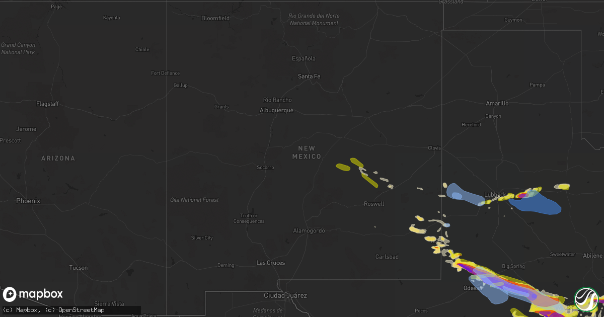
Hail Map in New Mexico on May 24, 2022
Get this storm
May 24 map
$229
one time, instant access
Download today. No call, no setup
Keep the $229
Bought the map and want the full workflow? Apply the entire $229 to a subscription within 7 days. None of it is wasted.
Every map, not just this one
This buys you this map. Subscription and you get every map we run, in the markets you choose from a few cities to whole states to nationwide. Plus real-time alerts the moment a storm fires.
Contact data
Name, contact info, occupancy, even credit band for addresses in the footprint. You go from where it hit to who to call.
Become the source they trust
Unlimited branding weather history reports on demand. You already have the documented answer ready for the property owner, and you are the one who showed up with it.
Property data and RoofTrace estimates
Pull up any address you have got, its value and the exact code rules for that jurisdiction, straight from One Click Code. Then RoofTrace estimates the squares, pitch, and roof value, priced the way you price.
Storm reports in New Mexico
New Mexico
| Date | Description |
|---|---|
| 05/24/20226:25 PM CDT | Report from mping: trees uprooted or snapped; roof blown off. |
| 05/24/20226:11 PM CDT | Report from mping: trees uprooted or snapped; roof blown off. |
| 05/24/20225:07 PM CDT | Report from mping: 1-inch tree limbs broken; shingles blown off. |
| 05/24/20223:40 PM CDT | Mesonet station tr724 roswell no. 1 portable. |
| 05/24/20223:24 PM CDT | A local report indicates 1.00 inch wind near 11 S KENNA |
| 05/24/20223:05 PM CDT | Report from mping: golf ball |
| 05/24/20223:02 PM CDT | Report from mping: quarter |
| 05/24/20222:54 PM CDT | Report from mping: golf ball |
| 05/24/20222:11 PM CDT | Along u.s. Highway 285 at mile marker 144. |
| 05/24/20227:29 AM CDT | At 1228 PM MDT, severe thunderstorms were located along a line extending from near Mesa to 22 miles south of Ramon, moving southeast at 20 mph. HAZARD...60 mph wind gusts and quarter size hail. SOURCE...Radar indicated. IMPACT...Hail damage to vehicles is expected. Expect wind damage to roofs, siding, and trees. Locations impacted include... Mesa.This includes Highway 285 between Mile Markers 131 and 161. |
| 05/24/20226:50 AM CDT | At 1150 AM MDT, a severe thunderstorm was located 8 miles south of Ramon, or 39 miles southeast of Vaughn, moving east at 15 mph. HAZARD...60 mph wind gusts and half dollar size hail. SOURCE...Radar indicated. IMPACT...Hail damage to vehicles is expected. Expect wind damage to roofs, siding, and trees. Locations impacted include... Mesa.This includes Highway 285 between Mile Markers 150 and 174. |
| 05/23/202211:04 PM CDT | At 404 PM CDT, severe thunderstorms were located along a line extending from Arch to 5 miles west of Maple to 5 miles southeast of Milnesand, moving east at 45 mph. HAZARD...60 mph wind gusts and quarter size hail. SOURCE...Radar indicated. The West Texas Mesonet at Dora, New Mexico, measured a wind gust of 56 mph at 355 PM CDT. IMPACT...Hail damage to vehicles is expected. Expect wind damage to roofs, siding, and trees. Locations impacted include... Levelland, Morton, Sundown, Needmore, Bledsoe, Enochs, Muleshoe Wildlife Refuge, Bula, Pep, Lehman, Maple, Whiteface and Opdyke West. |
| 05/23/202210:05 PM CDT | At 304 PM CDT/204 PM MDT/, a severe thunderstorm was located over Humble City, or near Hobbs, moving northeast at 30 mph. HAZARD...60 mph wind gusts and quarter size hail. SOURCE...Public. IMPACT...Hail damage to vehicles is expected. Expect wind damage to roofs, siding, and trees. Locations impacted include... Hobbs, Humble City, Industrial Airpark and Knowles. |
| 05/23/202210:02 PM CDT | At 302 PM CDT/202 PM MDT/, a severe thunderstorm was located over Nadine, or 10 miles south of Hobbs, moving southeast at 15 mph. HAZARD...60 mph wind gusts and quarter size hail. SOURCE...Radar indicated. IMPACT...Hail damage to vehicles is expected. Expect wind damage to roofs, siding, and trees. Locations impacted include... Hobbs and Nadine. |
| 05/23/20229:44 PM CDT | At 243 PM MDT, a severe thunderstorm was located near Portales, moving east at 20 mph. HAZARD...60 mph wind gusts and quarter size hail. SOURCE...Radar indicated. IMPACT...Hail damage to vehicles is expected. Expect wind damage to roofs, siding, and trees. Locations impacted include... Portales. |
| 05/23/20229:24 PM CDT | At 223 PM MDT, a severe thunderstorm was located 7 miles south of Kenna, or 39 miles southwest of Portales, moving east at 30 mph. HAZARD...60 mph wind gusts and quarter size hail. SOURCE...Radar indicated. IMPACT...Hail damage to vehicles is expected. Expect wind damage to roofs, siding, and trees. Locations impacted include... Dora, Milnesand, Pep and Kenna. |
| 05/23/20228:42 PM CDT | At 142 PM MDT, a severe thunderstorm was located near Maljamar, or 21 miles west of Lovington, moving east at 30 mph. HAZARD...60 mph wind gusts and quarter size hail. SOURCE...Radar indicated. IMPACT...Hail damage to vehicles is expected. Expect wind damage to roofs, siding, and trees. Locations impacted include... Lovington and Maljamar. |
| 05/23/20228:30 PM CDT | At 130 PM MDT, severe thunderstorms were located along a line extending from 13 miles northwest of Elkins to 14 miles northeast of Arabela, moving southeast at 25 mph. HAZARD...60 mph wind gusts and quarter size hail. SOURCE...Radar indicated. IMPACT...Hail damage to vehicles is expected. Expect wind damage to roofs, siding, and trees. Locations impacted include... Elkins.This includes Highway 285 between Mile Markers 119 and 150. |
All States Impacted by Hail Map on May 24, 2022
Cities Impacted by Hail Map on May 24, 2022
- Equality, AL
- Lott, TX
- Vienna, GA
- Byromville, GA
- Tatum, NM
- Claxton, GA
- Statesboro, GA
- Pembroke, GA
- Register, GA
- Roswell, NM
- Cottonport, LA
- Mansura, LA
- Plains, TX
- Denver City, TX
- Lovington, NM
- Albany, GA
- Amite, LA
- Lexington, TX
- Caldwell, TX
- Munford, AL
- Lorenzo, TX
- Slaton, TX
- Ransom Canyon, TX
- Ralls, TX
- Hobbs, NM
- Hensley, AR
- Little Rock, AR
- England, AR
- Scott, AR
- Paducah, TX
- Omaha, GA
- Pittsview, AL
- Junction, TX
- Vancourt, TX
- Strong, AR
- Rocksprings, TX
- Paint Rock, TX
- Tahoka, TX
- Post, TX
- Pitts, GA
- Rochelle, GA
- Baird, TX
- Weaver, AL
- Jacksonville, AL
- Anniston, AL
- Piedmont, AL
- Marble Falls, TX
- Llano, TX
- Fredericksburg, TX
- Burnet, TX
- Spicewood, TX
- Bertram, TX
- Horseshoe Bay, TX
- Round Mountain, TX
- Kingsland, TX
- Johnson City, TX
- Willow City, TX
- Bainbridge, GA
- Adrian, GA
- Soperton, GA
- Ropesville, TX
- Meadow, TX
- Brady, TX
- Menard, TX
- Barnhart, TX
- Big Lake, TX
- Mertzon, TX
- Utopia, TX
- Medina, TX
- San Angelo, TX
- Doole, TX
- Lake Arthur, NM
- Vidalia, GA
- Lyons, GA
- Oxford, AL
- Ingram, TX
- Lower Peach Tree, AL
- Thrall, TX
- Ozona, TX
- Cordele, GA
- Cobb, GA
- Hext, TX
- London, TX
- San Saba, TX
- Pine Apple, AL
- Dickens, TX
- Crosbyton, TX
- Baton Rouge, LA
- Greenwell Springs, LA
- Christoval, TX
- Eldorado, TX
- Wetumpka, AL
- Morton, TX
- Concepcion, TX
- Kellyton, AL
- Rockford, AL
- Andrews, TX
- Seminole, TX
- Uvalda, GA
- Ailey, GA
- Jonesville, LA
- Monterey, LA
- Pelham, GA
- Camilla, GA
- Manor, TX
- Elgin, TX
- Cuthbert, GA
- Monticello, FL
- Sylvester, GA
- Marianna, FL
- Cherokee, TX
- Lampasas, TX
- Bluffton, TX
- Buchanan Dam, TX
- Tow, TX
- Valley Spring, TX
- Brackettville, TX
- Elida, NM
- Eunice, NM
- Ashville, AL
- Wolfforth, TX
- Lubbock, TX
- Mountain Home, TX
- Warwick, GA
- Oakfield, GA
- Comstock, TX
- Thorndale, TX
- Asherton, TX
- Midland, TX
- Sonora, TX
- Jacksonville, GA
- McRae Helena, GA
- Washington, LA
- Palmetto, LA
- Goldthwaite, TX
- Evant, TX
- Gainestown, AL
- Uriah, AL
- George West, TX
- Tilden, TX
- Calliham, TX
- Cotulla, TX
- Fowlerton, TX
- Monroeville, AL
- Peterman, AL
- Franklin, AL
- Vredenburgh, AL
- Campbellton, FL
- Valera, TX
- Melvin, TX
- Priddy, TX
- Eola, TX
- Gustine, TX
- Stanton, TX
- Hamilton, TX
- Mullin, TX
- Santa Anna, TX
- Mereta, TX
- Gardendale, TX
- Brookesmith, TX
- Carlsbad, TX
- Early, TX
- Comanche, TX
- Big Spring, TX
- Rockwood, TX
- Sterling City, TX
- Ballinger, TX
- Rochelle, TX
- Wall, TX
- Voss, TX
- Lohn, TX
- Gouldbusk, TX
- Rowena, TX
- Coleman, TX
- Zephyr, TX
- Garden City, TX
- Goodfellow Afb, TX
- Brownwood, TX
- Eden, TX
- Talpa, TX
- Millersview, TX
- Bangs, TX
- Richland Springs, TX
- Miles, TX
- Robert Lee, TX
- Selma, AL
- Bunkie, LA
- Premont, TX
- Falfurrias, TX
- Jackson, AL
- Eagle Pass, TX
- Sabinal, TX
- Pinehurst, GA
- Mason, TX
- Castell, TX
- Art, TX
- Robstown, TX
- La Pryor, TX
- Laredo, TX
- Quemado, TX
- Del Rio, TX
- Crystal City, TX
- Fredonia, TX
- Voca, TX
- Pontotoc, TX
- Vanderpool, TX
- Leakey, TX
- Hunt, TX
- Alice, TX
- Uvalde, TX
- Carrizo Springs, TX
- Batesville, TX
- Big Wells, TX
- Barksdale, TX
- San Diego, TX
- Dryden, TX
- Doerun, GA
- Moultrie, GA
- Austin, TX
- Brinson, GA
- Bandera, TX
- Odessa, TX
- Holden, LA
- Baconton, GA
- Clyde, TX
- Banks, AR
- Hermitage, AR
- Benavides, TX
- Tarpley, TX
- Georgetown, GA
- Morris, GA
- Fort Gaines, GA
- Comfort, TX
- Center Point, TX
- Littlefield, TX
- Levelland, TX
- Seymour, TX
- Corona, NM
- Blanket, TX
- Spur, TX
- Camp Wood, TX
- Mirando City, TX
- Dripping Springs, TX
- Three Rivers, TX
- Brooksville, MS
- West Point, MS
- Crawford, MS
- Caledonia, MS
- Ethelsville, AL
- Shuqualak, MS
- Sulligent, AL
- Macon, MS
- Steens, MS
- Columbus, MS
- Millport, AL
- Vernon, AL
- Sundown, TX
- Whiteface, TX
- Snyder, TX
- Justiceburg, TX
- Aspermont, TX
- Jayton, TX
- Girard, TX
- Midkiff, TX
- Purmela, TX
- Star, TX
- Kempner, TX
- Salado, TX
- Killeen, TX
- Copperas Cove, TX
- Fort Hood, TX
- Briggs, TX
- Florence, TX
- Harker Heights, TX
- Blanco, TX
- Kerrville, TX
- Boerne, TX
- Wimberley, TX
- Hye, TX
- Harper, TX
- Stonewall, TX
- Encinal, TX
- Hondo, TX
- Floresville, TX
- La Coste, TX
- Beeville, TX
- Karnes City, TX
- Marion, TX
- Wrightsboro, TX
- San Antonio, TX
- Converse, TX
- Von Ormy, TX
- Jbsa Lackland, TX
- Rio Medina, TX
- Schertz, TX
- Westhoff, TX
- Poth, TX
- Devine, TX
- Runge, TX
- Nordheim, TX
- Nixon, TX
- Sutherland Springs, TX
- Smiley, TX
- Cost, TX
- Jbsa Ft Sam Houston, TX
- Yorktown, TX
- Leesville, TX
- Seguin, TX
- Atascosa, TX
- Hobson, TX
- Cuero, TX
- La Vernia, TX
- Gonzales, TX
- Adkins, TX
- Ecleto, TX
- D Hanis, TX
- Kenedy, TX
- Goliad, TX
- Castroville, TX
- Saint Hedwig, TX
- Gillett, TX
- Stockdale, TX
- Elmendorf, TX
- Falls City, TX
- Del Valle, TX
- La Grange, TX
- Cedar Creek, TX
- Round Top, TX
- Carmine, TX
- West Point, TX
- Fayetteville, TX
- Giddings, TX
- Bastrop, TX
- Ledbetter, TX
- Taylor, TX
- Coupland, TX
- Brenham, TX
- Pflugerville, TX
- Paige, TX
- Dime Box, TX
- Cedar Park, TX
- Round Rock, TX
- Smithville, TX
- Hutto, TX
- Lincoln, TX
- McDade, TX
- Somerville, TX
- Burton, TX
- Brookshire, TX
- Catarina, TX
- Katy, TX
- Inez, TX
- Victoria, TX
- Yoakum, TX
- Pensacola, FL
- Grove Hill, AL
- Thomasville, AL


