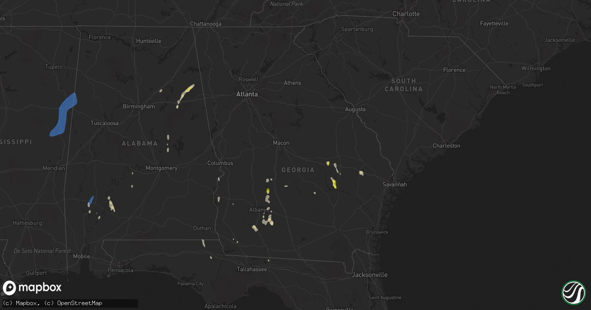
Hail Map in Georgia on May 24, 2022
Get this storm
May 24 map
$229
one time, instant access
Download today. No call, no setup
Keep the $229
Bought the map and want the full workflow? Apply the entire $229 to a subscription within 7 days. None of it is wasted.
Every map, not just this one
This buys you this map. Subscription and you get every map we run, in the markets you choose from a few cities to whole states to nationwide. Plus real-time alerts the moment a storm fires.
Contact data
Name, contact info, occupancy, even credit band for addresses in the footprint. You go from where it hit to who to call.
Become the source they trust
Unlimited branding weather history reports on demand. You already have the documented answer ready for the property owner, and you are the one who showed up with it.
Property data and RoofTrace estimates
Pull up any address you have got, its value and the exact code rules for that jurisdiction, straight from One Click Code. Then RoofTrace estimates the squares, pitch, and roof value, priced the way you price.
Storm reports in Georgia
Georgia
| Date | Description |
|---|---|
| 05/24/20225:48 PM CDT | Numerous trees reported down near the intersection of ferguson rd and creek trail rd |
| 05/24/20224:45 PM CDT | Multiple trees were reported down near the intersection of neville dairy and beasley roads. Time estimated by radar. |
| 05/24/20224:28 PM CDT | Tree down near intersection of vienna rd and pool gin house rd |
| 05/24/20224:26 PM CDT | Trees reported down near the intersection of ed stephens rd and flintside dr. |
| 05/24/20224:24 PM CDT | Trees down near the intersection of valhalla rd s and cannon rd |
| 05/24/20224:21 PM CDT | Quarter size hail reported near town of wenona |
| 05/24/20224:20 PM CDT | Tree reported down near intersection of ferry landing rd and clay pit rd |
| 05/24/20223:35 PM CDT | Whiddon mill rd at willis rd... Winds were strong enough to over turn an irrigation system into the roadway and multiple trees down just east of willis rd. |
| 05/24/20223:15 PM CDT | Tree down over highway... About midway up hwy 313. |
| 05/24/20223:08 PM CDT | Tree down over road in camilla... 500 block south macarthur. |
| 05/24/20223:01 PM CDT | 4-inch diameter tree limbs broken. Corrected location. |
| 05/24/20222:55 PM CDT | Law enforcement reports a tree over a roadway at the south end of worth county. Location approximate. |
| 05/24/20222:47 PM CDT | 4-inch diameter tree limbs broken. |
| 05/24/20222:19 PM CDT | Trained spotter reports a tin roof peeled back on a pig barn on ga hwy 33 n. Time was recorded by video camera. |
| 05/24/20221:29 AM CDT | At 629 PM EDT, a severe thunderstorm was located over Center, or 7 miles southwest of Lyons, moving north at 25 mph. HAZARD...60 mph wind gusts and quarter size hail. SOURCE...Radar indicated. IMPACT...Hail damage to vehicles is expected. Expect wind damage to roofs, siding, and trees. Locations impacted include... Lyons, Vidalia, Higgston, Santa Claus, Alston, South Thompson, Center, Rock Springs, Kibbee and Normantown. |
| 05/24/202212:41 AM CDT | At 540 PM CDT, a severe thunderstorm was located 10 miles south of Fort Benning/lawson Army Air Fld, or 15 miles southwest of Cusseta, moving north at 35 mph. HAZARD...60 mph wind gusts and quarter size hail. SOURCE...Radar indicated. IMPACT...Hail damage to vehicles is expected. Expect wind damage to roofs, siding, and trees. Locations impacted include... Phenix City, Ladonia, Uchee Creek, Fort Mitchell, Ladonia Sports Complex, Fort Mitchell Activity Center and Phenix Drag Strip. |
| 05/24/202212:37 AM CDT | At 537 PM EDT, severe thunderstorms were located along a line extending from near Nevils to near Claxton, moving northwest at 15 mph. HAZARD...60 mph wind gusts and penny size hail. SOURCE...Radar indicated. IMPACT...Expect damage to trees and powerlines. Locations impacted include: Statesboro, Metter, Brooklet, Hagan, Portal, Pulaski, Register, Nevils, Aline, Georgia Southern, Hopeulikit and Denmark.This warning includes I-16 between mile markers 99 and 126. |
| 05/24/202212:31 AM CDT | At 531 PM EDT, severe thunderstorms were located along a line extending from Lamar to near Georgia Veterans Memorial St Pk to Cordele, moving north at 25 mph. HAZARD...60 mph wind gusts and quarter size hail. SOURCE...Radar indicated. IMPACT...Hail damage to vehicles is expected. Expect wind damage to roofs, siding, and trees. Locations impacted include... Cordele, Vienna, Leslie, Lilly, De Soto, Desoto, Cobb, Lamar, Georgia Veterans Memorial St Pk, Richwood, New Era, Flint River Wma, Pennington, Drayton, Methvins and Wenona. |
| 05/24/202212:27 AM CDT | At 527 PM EDT, a severe thunderstorm was located near Workmore, or 10 miles south of McRae, moving north at 20 mph. HAZARD...60 mph wind gusts and quarter size hail. SOURCE...Radar indicated. IMPACT...Hail damage to vehicles is expected. Expect wind damage to roofs, siding, and trees. Locations impacted include... McRae, Helena, Milan, Scotland, Workmore and Little Ocmulgee State Park. |
| 05/24/202212:05 AM CDT | At 504 PM EDT, a severe thunderstorm was located over Fort Early, or 10 miles southwest of Cordele, moving north at 30 mph. HAZARD...60 mph wind gusts and penny size hail. SOURCE...Radar indicated. IMPACT...Expect damage to roofs, siding, and trees. Locations impacted include... Cordele, Vienna, Cobb, Lamar, Fort Early, Drayton, Georgia Veterans Memorial St Pk, Richwood and Raines. |
| 05/23/202211:30 PM CDT | At 430 PM EDT, a severe thunderstorm was located near Omega, or 7 miles southwest of Tifton, moving north at 20 mph. HAZARD...60 mph wind gusts and quarter size hail. SOURCE...Radar indicated. IMPACT...Hail damage to vehicles is expected. Expect wind damage to roofs, siding, and trees. Locations impacted include... Sylvester, Tifton, Omega, Norman Park, Poulan, Ty Ty, Phillipsburg, Unionville, Terrell, Sumner, Hillsdale, Eldorado, Chula, Scooterville, Inaha, Tift Airport, Coverdale, Fender, Crosland and Shingler. |
| 05/23/202211:06 PM CDT | At 406 PM EDT, severe thunderstorms were located along a line extending from near Doerun to 9 miles west of Camilla, moving north at 15 mph. HAZARD...60 mph wind gusts and penny size hail. SOURCE...Radar indicated. IMPACT...Expect damage to roofs, siding, and trees. Locations impacted include... Newton, Putney, Camilla, Albany, Baconton, Doerun, Marine Corps Logistics Base, Bridgeboro, Flint, Radium Springs, Red Store Crossroads, Ticknor, Pecan City, Lester, Pritchetts, Freeman, Mitchell Co A/P, Williamsburg, Greenough and Elmodel Wma. |
| 05/23/202210:56 PM CDT | At 355 PM EDT, a severe thunderstorm was located 7 miles north of Doerun, or 7 miles southwest of Sylvester, moving northwest at 20 mph. HAZARD...60 mph wind gusts and penny size hail. SOURCE...Radar indicated. At 347 pm EDT, penny sized hail and damage to tree limbs were reported 2 miles north- northwest of Anderson City. IMPACT...Expect damage to roofs, siding, and trees. Locations impacted include... Sylvester, Albany, Poulan, Marine Corps Logistics Base, Bridgeboro, Gordy, Livingston, Sylvester Airport, Anderson City, Tempy, Parkerville, Powelltown, Pecan City, Red Rock, Acree, Pritchetts, Gammage, Crestwood, Isabella and Alfords. |
| 05/23/202210:26 PM CDT | At 326 PM EDT, a severe thunderstorm was located near Doerun, or 11 miles north of Moultrie, moving northwest at 25 mph. HAZARD...60 mph wind gusts and penny size hail. SOURCE...Radar indicated. IMPACT...Expect damage to roofs, siding, and trees. Locations impacted include... Sylvester, Doerun, Poulan, Schley, Bridgeboro, Minton, Gordy, Livingston, Anderson City, Ticknor, Tempy, Minnesota, Parkerville, Powelltown, Sigsbee, Pritchetts, Gammage, Crestwood, Isabella and New Elm. |
All States Impacted by Hail Map on May 24, 2022
Cities Impacted by Hail Map on May 24, 2022
- Equality, AL
- Lott, TX
- Vienna, GA
- Byromville, GA
- Tatum, NM
- Claxton, GA
- Statesboro, GA
- Pembroke, GA
- Register, GA
- Roswell, NM
- Cottonport, LA
- Mansura, LA
- Plains, TX
- Denver City, TX
- Lovington, NM
- Albany, GA
- Amite, LA
- Lexington, TX
- Caldwell, TX
- Munford, AL
- Lorenzo, TX
- Slaton, TX
- Ransom Canyon, TX
- Ralls, TX
- Hobbs, NM
- Hensley, AR
- Little Rock, AR
- England, AR
- Scott, AR
- Paducah, TX
- Omaha, GA
- Pittsview, AL
- Junction, TX
- Vancourt, TX
- Strong, AR
- Rocksprings, TX
- Paint Rock, TX
- Tahoka, TX
- Post, TX
- Pitts, GA
- Rochelle, GA
- Baird, TX
- Weaver, AL
- Jacksonville, AL
- Anniston, AL
- Piedmont, AL
- Marble Falls, TX
- Llano, TX
- Fredericksburg, TX
- Burnet, TX
- Spicewood, TX
- Bertram, TX
- Horseshoe Bay, TX
- Round Mountain, TX
- Kingsland, TX
- Johnson City, TX
- Willow City, TX
- Bainbridge, GA
- Adrian, GA
- Soperton, GA
- Ropesville, TX
- Meadow, TX
- Brady, TX
- Menard, TX
- Barnhart, TX
- Big Lake, TX
- Mertzon, TX
- Utopia, TX
- Medina, TX
- San Angelo, TX
- Doole, TX
- Lake Arthur, NM
- Vidalia, GA
- Lyons, GA
- Oxford, AL
- Ingram, TX
- Lower Peach Tree, AL
- Thrall, TX
- Ozona, TX
- Cordele, GA
- Cobb, GA
- Hext, TX
- London, TX
- San Saba, TX
- Pine Apple, AL
- Dickens, TX
- Crosbyton, TX
- Baton Rouge, LA
- Greenwell Springs, LA
- Christoval, TX
- Eldorado, TX
- Wetumpka, AL
- Morton, TX
- Concepcion, TX
- Kellyton, AL
- Rockford, AL
- Andrews, TX
- Seminole, TX
- Uvalda, GA
- Ailey, GA
- Jonesville, LA
- Monterey, LA
- Pelham, GA
- Camilla, GA
- Manor, TX
- Elgin, TX
- Cuthbert, GA
- Monticello, FL
- Sylvester, GA
- Marianna, FL
- Cherokee, TX
- Lampasas, TX
- Bluffton, TX
- Buchanan Dam, TX
- Tow, TX
- Valley Spring, TX
- Brackettville, TX
- Elida, NM
- Eunice, NM
- Ashville, AL
- Wolfforth, TX
- Lubbock, TX
- Mountain Home, TX
- Warwick, GA
- Oakfield, GA
- Comstock, TX
- Thorndale, TX
- Asherton, TX
- Midland, TX
- Sonora, TX
- Jacksonville, GA
- McRae Helena, GA
- Washington, LA
- Palmetto, LA
- Goldthwaite, TX
- Evant, TX
- Gainestown, AL
- Uriah, AL
- George West, TX
- Tilden, TX
- Calliham, TX
- Cotulla, TX
- Fowlerton, TX
- Monroeville, AL
- Peterman, AL
- Franklin, AL
- Vredenburgh, AL
- Campbellton, FL
- Valera, TX
- Melvin, TX
- Priddy, TX
- Eola, TX
- Gustine, TX
- Stanton, TX
- Hamilton, TX
- Mullin, TX
- Santa Anna, TX
- Mereta, TX
- Gardendale, TX
- Brookesmith, TX
- Carlsbad, TX
- Early, TX
- Comanche, TX
- Big Spring, TX
- Rockwood, TX
- Sterling City, TX
- Ballinger, TX
- Rochelle, TX
- Wall, TX
- Voss, TX
- Lohn, TX
- Gouldbusk, TX
- Rowena, TX
- Coleman, TX
- Zephyr, TX
- Garden City, TX
- Goodfellow Afb, TX
- Brownwood, TX
- Eden, TX
- Talpa, TX
- Millersview, TX
- Bangs, TX
- Richland Springs, TX
- Miles, TX
- Robert Lee, TX
- Selma, AL
- Bunkie, LA
- Premont, TX
- Falfurrias, TX
- Jackson, AL
- Eagle Pass, TX
- Sabinal, TX
- Pinehurst, GA
- Mason, TX
- Castell, TX
- Art, TX
- Robstown, TX
- La Pryor, TX
- Laredo, TX
- Quemado, TX
- Del Rio, TX
- Crystal City, TX
- Fredonia, TX
- Voca, TX
- Pontotoc, TX
- Vanderpool, TX
- Leakey, TX
- Hunt, TX
- Alice, TX
- Uvalde, TX
- Carrizo Springs, TX
- Batesville, TX
- Big Wells, TX
- Barksdale, TX
- San Diego, TX
- Dryden, TX
- Doerun, GA
- Moultrie, GA
- Austin, TX
- Brinson, GA
- Bandera, TX
- Odessa, TX
- Holden, LA
- Baconton, GA
- Clyde, TX
- Banks, AR
- Hermitage, AR
- Benavides, TX
- Tarpley, TX
- Georgetown, GA
- Morris, GA
- Fort Gaines, GA
- Comfort, TX
- Center Point, TX
- Littlefield, TX
- Levelland, TX
- Seymour, TX
- Corona, NM
- Blanket, TX
- Spur, TX
- Camp Wood, TX
- Mirando City, TX
- Dripping Springs, TX
- Three Rivers, TX
- Brooksville, MS
- West Point, MS
- Crawford, MS
- Caledonia, MS
- Ethelsville, AL
- Shuqualak, MS
- Sulligent, AL
- Macon, MS
- Steens, MS
- Columbus, MS
- Millport, AL
- Vernon, AL
- Sundown, TX
- Whiteface, TX
- Snyder, TX
- Justiceburg, TX
- Aspermont, TX
- Jayton, TX
- Girard, TX
- Midkiff, TX
- Purmela, TX
- Star, TX
- Kempner, TX
- Salado, TX
- Killeen, TX
- Copperas Cove, TX
- Fort Hood, TX
- Briggs, TX
- Florence, TX
- Harker Heights, TX
- Blanco, TX
- Kerrville, TX
- Boerne, TX
- Wimberley, TX
- Hye, TX
- Harper, TX
- Stonewall, TX
- Encinal, TX
- Hondo, TX
- Floresville, TX
- La Coste, TX
- Beeville, TX
- Karnes City, TX
- Marion, TX
- Wrightsboro, TX
- San Antonio, TX
- Converse, TX
- Von Ormy, TX
- Jbsa Lackland, TX
- Rio Medina, TX
- Schertz, TX
- Westhoff, TX
- Poth, TX
- Devine, TX
- Runge, TX
- Nordheim, TX
- Nixon, TX
- Sutherland Springs, TX
- Smiley, TX
- Cost, TX
- Jbsa Ft Sam Houston, TX
- Yorktown, TX
- Leesville, TX
- Seguin, TX
- Atascosa, TX
- Hobson, TX
- Cuero, TX
- La Vernia, TX
- Gonzales, TX
- Adkins, TX
- Ecleto, TX
- D Hanis, TX
- Kenedy, TX
- Goliad, TX
- Castroville, TX
- Saint Hedwig, TX
- Gillett, TX
- Stockdale, TX
- Elmendorf, TX
- Falls City, TX
- Del Valle, TX
- La Grange, TX
- Cedar Creek, TX
- Round Top, TX
- Carmine, TX
- West Point, TX
- Fayetteville, TX
- Giddings, TX
- Bastrop, TX
- Ledbetter, TX
- Taylor, TX
- Coupland, TX
- Brenham, TX
- Pflugerville, TX
- Paige, TX
- Dime Box, TX
- Cedar Park, TX
- Round Rock, TX
- Smithville, TX
- Hutto, TX
- Lincoln, TX
- McDade, TX
- Somerville, TX
- Burton, TX
- Brookshire, TX
- Catarina, TX
- Katy, TX
- Inez, TX
- Victoria, TX
- Yoakum, TX
- Pensacola, FL
- Grove Hill, AL
- Thomasville, AL


