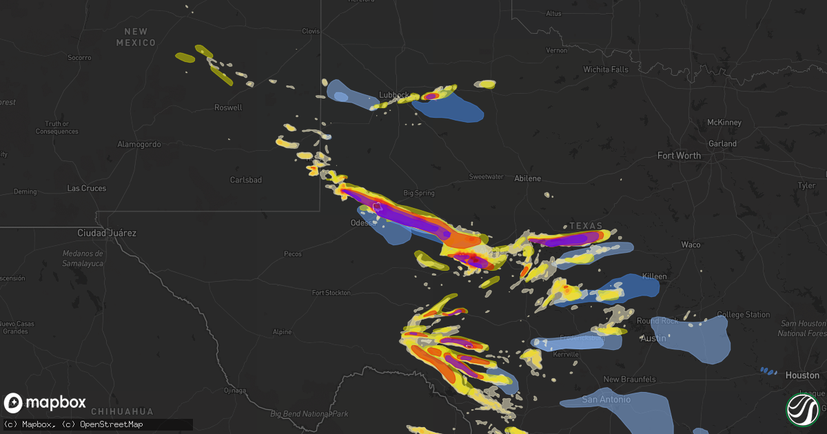
Hail Map on May 24, 2022
Get this storm
May 24 map
$229
one time, instant access
Download today. No call, no setup
Keep the $229
Bought the map and want the full workflow? Apply the entire $229 to a subscription within 7 days. None of it is wasted.
Every map, not just this one
This buys you this map. Subscription and you get every map we run, in the markets you choose from a few cities to whole states to nationwide. Plus real-time alerts the moment a storm fires.
Contact data
Name, contact info, occupancy, even credit band for addresses in the footprint. You go from where it hit to who to call.
Become the source they trust
Unlimited branding weather history reports on demand. You already have the documented answer ready for the property owner, and you are the one who showed up with it.
Property data and RoofTrace estimates
Pull up any address you have got, its value and the exact code rules for that jurisdiction, straight from One Click Code. Then RoofTrace estimates the squares, pitch, and roof value, priced the way you price.
States Impacted by Hail Map on May 24, 2022
Storm reports
Arkansas
| Date | Description |
|---|---|
| 05/24/20225:35 PM CDT | A large tree was blown down... Partially onto a home. A metal carport was also damaged. |
| 05/24/20224:15 AM CDT | At 914 PM CDT, a severe thunderstorm was located near Greenfield, or 8 miles southwest of Jonesboro, moving northeast at 35 mph. HAZARD...60 mph wind gusts and penny size hail. SOURCE...Radar indicated. IMPACT...Expect damage to roofs, siding, and trees. Locations impacted include... Jonesboro, Paragould, Bono, Bay, Brookland, Crowleys Ridge State Park, Lake Frierson State Park, Cash, Walcott, Fontaine, Greenfield, Hergett, Apt, Valley View, Schug, Gum Point, Farrville, Dorothy, Winesburg and Light. |
| 05/24/20223:39 AM CDT | At 839 PM CDT, a severe thunderstorm was located over Hickory Ridge, or 13 miles northwest of Wynne, moving northeast at 40 mph. HAZARD...60 mph wind gusts and nickel size hail. SOURCE...Radar indicated. IMPACT...Expect damage to roofs, siding, and trees. Locations impacted include... Jonesboro, Harrisburg, Weiner, Cash, Hickory Ridge, Waldenburg, Greenfield, Fisher, Hydrick, Wiley Crossing, Pittinger, Supply, Tilton, Brushy Lake, Risher, Gilkerson, Otwell, Cary, Hamlin and Dryden. |
| 05/24/20222:35 AM CDT | At 735 PM CDT, severe thunderstorms were located along a line extending from 8 miles southeast of Cass to Woodland to Scranton, moving northeast at 40 mph. HAZARD...60 mph wind gusts and penny size hail. SOURCE...Radar indicated. IMPACT...Expect damage to roofs, siding, and trees. Locations impacted include... Clarksville... Lamar... Knoxville... Scranton... Dillen... Woodland... Upper Buffalo Wilderness Area... Devils Knob... Midway in Logan County... Walnut... Spadra... Bertha... Tokalon... Holman... Rosetta... Lake Dardanelle... Morrison Bluff... Oak Grove in Johnson County... Catalpa... Fort Douglas...This includes Interstate 40 between mile markers 54 and 68. |
| 05/24/20221:55 AM CDT | At 655 PM CDT, severe thunderstorms were located along a line extending from near Ozark to near Paris, moving northeast at 50 mph. HAZARD...60 mph wind gusts and penny size hail. SOURCE...Radar indicated. IMPACT...Expect damage to roofs, siding, and trees. Locations impacted include... Clarksville... Paris... Lamar... Magazine... Knoxville... Subiaco... Hartman... Scranton... Ratcliff... Blue Mountain... Woodland... Hinkle... Hoyt... Mount Magazine... Midway in Logan County... Spadra... Tokalon... Lake Dardanelle... Coal Hill... Caulksville...This includes Interstate 40 between mile markers 44 and 65. |
| 05/24/20221:53 AM CDT | At 653 PM CDT, a severe thunderstorm was located 6 miles southwest of Ozark, moving northeast at 25 mph. HAZARD...60 mph wind gusts. SOURCE...Radar indicated. IMPACT...Expect damage to roofs, siding, and trees. Locations in or near the path include... Ozark... Altus... Branch... Denning... Wiederkehr Village... Etna... Alix... Peter Pender... Cecil... Meg...This includes Interstate 40 in Arkansas between mile markers 33 and42. |
| 05/24/202212:12 AM CDT | At 512 PM CDT, a severe thunderstorm was located near Wrightsville, or 13 miles southeast of Downtown Little Rock, moving northeast at 15 mph. HAZARD...60 mph wind gusts and quarter size hail. SOURCE...Radar indicated. IMPACT...Hail damage to vehicles is expected. Expect wind damage to roofs, siding, and trees. Locations impacted include... Little Rock... North Little Rock... Jacksonville... Wrightsville... Keo... Estes... Meto... Toltec Mounds State Park... Protho Junction... Scott... Sweet Home... McAlmont... Baucum... Bevis Corner... Higgins... College Station... Woodson... Kerr... Hensley... Bredlow Corner...This includes the following highways... Interstate 40 between mile markers 157 and 168. Interstate 530 between mile markers 6 and 9, and between milemarkers 13 and 16. Interstate 440 between mile markers 4 and 14. US Highway 67 between mile markers 6 and 8. |
| 05/23/202211:56 PM CDT | At 456 PM CDT, a severe thunderstorm was located near DeGray Lake State Park, or 11 miles northwest of Arkadelphia, moving northeast at 15 mph. HAZARD...60 mph wind gusts. SOURCE...Radar indicated. IMPACT...Expect damage to roofs, siding, and trees. Locations impacted include... DeGray Lake State Park... Bismarck... De Roche... |
| 05/23/202211:53 PM CDT | At 453 PM CDT, a severe thunderstorm was located 19 miles southwest of Octavia, or 34 miles southeast of Clayton, moving northeast at 40 mph. HAZARD...Quarter size hail. SOURCE...Radar indicated. IMPACT...Damage to vehicles is expected. Locations impacted include... Watson, Bethel, Battiest, Mount Herman, Smithville and Sherwood. |
Florida
| Date | Description |
|---|---|
| 05/24/20225:11 AM CDT | A storm survey team found scattered locations of wind damage across the pensacola/ferry pass areas in and around the vicinity of north davis dr. For much of this damage |
Missouri
| Date | Description |
|---|---|
| 05/24/20225:53 AM CDT | At 1052 PM CDT, severe thunderstorms were located along a line extending from near Hendrickson to near Harviell to near Glennonville to Holcomb, moving north at 45 mph. HAZARD...60 mph wind gusts and penny size hail. SOURCE...Radar indicated. IMPACT...Expect damage to roofs, siding, and trees. Severe thunderstorms will be near... Poplar Bluff around 1100 PM CDT. Fisk and Dudley around 1110 PM CDT.Other locations in the path of these severe thunderstorms includePuxico and Dexter. |
Louisiana
| Date | Description |
|---|---|
| 05/24/20226:14 PM CDT | Report from mping: 1-inch tree limbs broken; shingles blown off. |
| 05/24/20225:42 PM CDT | Peak gust of 58 knots observed at calcasieu pass |
| 05/24/20225:40 PM CDT | Peak gust of 61 mph measured at cameron mesonet observation |
Mississippi
| Date | Description |
|---|---|
| 05/24/20224:40 PM CDT | A few trees were down in a backyard. |
| 05/24/20224:35 PM CDT | Limbs down near steens... Reported via social media. |
| 05/24/20224:12 PM CDT | Tree fell on a house. Trees were also down near red bank road. |
| 05/23/202211:10 PM CDT | At 409 PM CDT, a severe thunderstorm was located near Bent Oak, or 12 miles southwest of Columbus, moving northeast at 40 mph. HAZARD...60 mph wind gusts and penny size hail. SOURCE...Radar indicated. IMPACT...Expect damage to roofs, siding, and trees. This severe thunderstorm will be near... Bent Oak around 415 PM CDT. Columbus around 425 PM CDT. Waverly around 430 PM CDT. Columbus AFB around 435 PM CDT. Steens around 440 PM CDT. Kolola Springs around 445 PM CDT. Caledonia around 450 PM CDT.Other locations impacted by this severe thunderstorm include Artesia. |
Alabama
| Date | Description |
|---|---|
| 05/24/20224:00 AM CDT | At 900 PM CDT, a severe thunderstorm was located near Jacksonville State University, or near Jacksonville, moving northeast at 15 mph. HAZARD...60 mph wind gusts and quarter size hail. SOURCE...Radar indicated. IMPACT...Hail damage to vehicles is expected. Expect wind damage to roofs, siding, and trees. Locations impacted include... Jacksonville, Piedmont, Jacksonville State University, Knightens Crossroads and Liberty Hill. |
| 05/24/202212:10 AM CDT | Nws employee estimated at least 60 mph gusts on st. Anrdews ct on dauphin island. |
| 05/23/202210:34 PM CDT | At 334 PM CDT, a severe thunderstorm was located near Mashulaville, or 16 miles northeast of Preston, moving northeast at 40 mph. HAZARD...60 mph wind gusts. SOURCE...Radar indicated. IMPACT...Expect damage to roofs, siding, and trees. This severe thunderstorm will be near... Macon around 340 PM CDT. Brooksville around 350 PM CDT. Deerbrook around 355 PM CDT. Crawford around 400 PM CDT. Columbus and Bent Oak around 415 PM CDT.Other locations impacted by this severe thunderstorm includeShuqualak and Artesia. |
| 05/23/20229:06 PM CDT | Lots of wind blown hail. |
| 05/23/20228:32 PM CDT | At 131 PM CDT, a severe thunderstorm was located 9 miles northwest of Peterman, or 10 miles north of Monroeville, moving north at 25 mph. HAZARD...60 mph wind gusts and quarter size hail. SOURCE...Radar indicated. IMPACT...Hail damage to vehicles is expected. Expect wind damage to roofs, siding, and trees. Locations impacted include... Pine Hill, Vredenburgh and Yellow Bluff. |
| 05/23/20228:01 PM CDT | At 100 PM CDT, a severe thunderstorm was located 5 miles west of Grove Hill, moving north at 40 mph. HAZARD...60 mph wind gusts and quarter size hail. SOURCE...Radar indicated. IMPACT...Hail damage to vehicles is expected. Expect wind damage to roofs, siding, and trees. Locations impacted include... Thomasville, Grove Hill and Fulton. |
| 05/23/20227:26 PM CDT | A single tree reported down along 1565 poplar creek near missionary baptist church south of leighton. An additional tree was reported down in the same general area. |
| 05/23/20227:05 PM CDT | A couple of trees reported down along county road 157 white oak ln in hatton. |
Georgia
| Date | Description |
|---|---|
| 05/24/20225:48 PM CDT | Numerous trees reported down near the intersection of ferguson rd and creek trail rd |
| 05/24/20224:45 PM CDT | Multiple trees were reported down near the intersection of neville dairy and beasley roads. Time estimated by radar. |
| 05/24/20224:28 PM CDT | Tree down near intersection of vienna rd and pool gin house rd |
| 05/24/20224:26 PM CDT | Trees reported down near the intersection of ed stephens rd and flintside dr. |
| 05/24/20224:24 PM CDT | Trees down near the intersection of valhalla rd s and cannon rd |
| 05/24/20224:21 PM CDT | Quarter size hail reported near town of wenona |
| 05/24/20224:20 PM CDT | Tree reported down near intersection of ferry landing rd and clay pit rd |
| 05/24/20223:35 PM CDT | Whiddon mill rd at willis rd... Winds were strong enough to over turn an irrigation system into the roadway and multiple trees down just east of willis rd. |
| 05/24/20223:15 PM CDT | Tree down over highway... About midway up hwy 313. |
| 05/24/20223:08 PM CDT | Tree down over road in camilla... 500 block south macarthur. |
| 05/24/20223:01 PM CDT | 4-inch diameter tree limbs broken. Corrected location. |
| 05/24/20222:55 PM CDT | Law enforcement reports a tree over a roadway at the south end of worth county. Location approximate. |
| 05/24/20222:47 PM CDT | 4-inch diameter tree limbs broken. |
| 05/24/20222:19 PM CDT | Trained spotter reports a tin roof peeled back on a pig barn on ga hwy 33 n. Time was recorded by video camera. |
| 05/24/20221:29 AM CDT | At 629 PM EDT, a severe thunderstorm was located over Center, or 7 miles southwest of Lyons, moving north at 25 mph. HAZARD...60 mph wind gusts and quarter size hail. SOURCE...Radar indicated. IMPACT...Hail damage to vehicles is expected. Expect wind damage to roofs, siding, and trees. Locations impacted include... Lyons, Vidalia, Higgston, Santa Claus, Alston, South Thompson, Center, Rock Springs, Kibbee and Normantown. |
| 05/24/202212:41 AM CDT | At 540 PM CDT, a severe thunderstorm was located 10 miles south of Fort Benning/lawson Army Air Fld, or 15 miles southwest of Cusseta, moving north at 35 mph. HAZARD...60 mph wind gusts and quarter size hail. SOURCE...Radar indicated. IMPACT...Hail damage to vehicles is expected. Expect wind damage to roofs, siding, and trees. Locations impacted include... Phenix City, Ladonia, Uchee Creek, Fort Mitchell, Ladonia Sports Complex, Fort Mitchell Activity Center and Phenix Drag Strip. |
| 05/24/202212:37 AM CDT | At 537 PM EDT, severe thunderstorms were located along a line extending from near Nevils to near Claxton, moving northwest at 15 mph. HAZARD...60 mph wind gusts and penny size hail. SOURCE...Radar indicated. IMPACT...Expect damage to trees and powerlines. Locations impacted include: Statesboro, Metter, Brooklet, Hagan, Portal, Pulaski, Register, Nevils, Aline, Georgia Southern, Hopeulikit and Denmark.This warning includes I-16 between mile markers 99 and 126. |
| 05/24/202212:31 AM CDT | At 531 PM EDT, severe thunderstorms were located along a line extending from Lamar to near Georgia Veterans Memorial St Pk to Cordele, moving north at 25 mph. HAZARD...60 mph wind gusts and quarter size hail. SOURCE...Radar indicated. IMPACT...Hail damage to vehicles is expected. Expect wind damage to roofs, siding, and trees. Locations impacted include... Cordele, Vienna, Leslie, Lilly, De Soto, Desoto, Cobb, Lamar, Georgia Veterans Memorial St Pk, Richwood, New Era, Flint River Wma, Pennington, Drayton, Methvins and Wenona. |
| 05/24/202212:27 AM CDT | At 527 PM EDT, a severe thunderstorm was located near Workmore, or 10 miles south of McRae, moving north at 20 mph. HAZARD...60 mph wind gusts and quarter size hail. SOURCE...Radar indicated. IMPACT...Hail damage to vehicles is expected. Expect wind damage to roofs, siding, and trees. Locations impacted include... McRae, Helena, Milan, Scotland, Workmore and Little Ocmulgee State Park. |
| 05/24/202212:05 AM CDT | At 504 PM EDT, a severe thunderstorm was located over Fort Early, or 10 miles southwest of Cordele, moving north at 30 mph. HAZARD...60 mph wind gusts and penny size hail. SOURCE...Radar indicated. IMPACT...Expect damage to roofs, siding, and trees. Locations impacted include... Cordele, Vienna, Cobb, Lamar, Fort Early, Drayton, Georgia Veterans Memorial St Pk, Richwood and Raines. |
| 05/23/202211:30 PM CDT | At 430 PM EDT, a severe thunderstorm was located near Omega, or 7 miles southwest of Tifton, moving north at 20 mph. HAZARD...60 mph wind gusts and quarter size hail. SOURCE...Radar indicated. IMPACT...Hail damage to vehicles is expected. Expect wind damage to roofs, siding, and trees. Locations impacted include... Sylvester, Tifton, Omega, Norman Park, Poulan, Ty Ty, Phillipsburg, Unionville, Terrell, Sumner, Hillsdale, Eldorado, Chula, Scooterville, Inaha, Tift Airport, Coverdale, Fender, Crosland and Shingler. |
| 05/23/202211:06 PM CDT | At 406 PM EDT, severe thunderstorms were located along a line extending from near Doerun to 9 miles west of Camilla, moving north at 15 mph. HAZARD...60 mph wind gusts and penny size hail. SOURCE...Radar indicated. IMPACT...Expect damage to roofs, siding, and trees. Locations impacted include... Newton, Putney, Camilla, Albany, Baconton, Doerun, Marine Corps Logistics Base, Bridgeboro, Flint, Radium Springs, Red Store Crossroads, Ticknor, Pecan City, Lester, Pritchetts, Freeman, Mitchell Co A/P, Williamsburg, Greenough and Elmodel Wma. |
| 05/23/202210:56 PM CDT | At 355 PM EDT, a severe thunderstorm was located 7 miles north of Doerun, or 7 miles southwest of Sylvester, moving northwest at 20 mph. HAZARD...60 mph wind gusts and penny size hail. SOURCE...Radar indicated. At 347 pm EDT, penny sized hail and damage to tree limbs were reported 2 miles north- northwest of Anderson City. IMPACT...Expect damage to roofs, siding, and trees. Locations impacted include... Sylvester, Albany, Poulan, Marine Corps Logistics Base, Bridgeboro, Gordy, Livingston, Sylvester Airport, Anderson City, Tempy, Parkerville, Powelltown, Pecan City, Red Rock, Acree, Pritchetts, Gammage, Crestwood, Isabella and Alfords. |
| 05/23/202210:26 PM CDT | At 326 PM EDT, a severe thunderstorm was located near Doerun, or 11 miles north of Moultrie, moving northwest at 25 mph. HAZARD...60 mph wind gusts and penny size hail. SOURCE...Radar indicated. IMPACT...Expect damage to roofs, siding, and trees. Locations impacted include... Sylvester, Doerun, Poulan, Schley, Bridgeboro, Minton, Gordy, Livingston, Anderson City, Ticknor, Tempy, Minnesota, Parkerville, Powelltown, Sigsbee, Pritchetts, Gammage, Crestwood, Isabella and New Elm. |
Texas
| Date | Description |
|---|---|
| 05/24/20226:45 PM CDT | Law enforcement reports power lines and trees down and a trailer flipped over in richland springs. |
| 05/24/20226:35 PM CDT | A local report indicates 70 MPH wind near 8 WNW BRADY |
| 05/24/20226:32 PM CDT | Midland international asos. |
| 05/24/20226:28 PM CDT | West texas mesonet. Wind has now gusted at or above 59 mph from 623 pm to 630 pm. |
| 05/24/20226:27 PM CDT | Golf ball sized hail near garden city. |
| 05/24/20226:25 PM CDT | West texas mesonet report. Wind gusts of 60 mph were also reported at 623 pm and 624 pm. |
| 05/24/20226:22 PM CDT | West texas mesonet report. A wind gust to 59 mph was also reported at 623 pm. |
| 05/24/20226:20 PM CDT | A local report indicates 1.00 inch wind near ZEPHYR |
| 05/24/20226:19 PM CDT | Report from mping: 1-inch tree limbs broken; shingles blown off. |
| 05/24/20226:17 PM CDT | A local report indicates 67 MPH wind near ROCHELLE |
| 05/24/20226:15 PM CDT | A local report indicates 2.50 inch wind near GARDEN CITY |
| 05/24/20226:00 PM CDT | Trees also blown down... And flooding into a garage. |
| 05/24/20225:53 PM CDT | A local report indicates 1.75 inch wind near BROOKESMITH |
| 05/24/20225:52 PM CDT | West texas mesonet. Wind gusted between 61 and 68 mph from 551 pm to 555 pm. |
| 05/24/20225:40 PM CDT | Report from mping: golf ball |
| 05/24/20225:39 PM CDT | Three power poles were blown down and three power poles were snapped. |
| 05/24/20225:36 PM CDT | Multiple reports of tennis ball sized hail near east loop 250. |
| 05/24/20225:34 PM CDT | A local report indicates 1.25 inch wind near 4 N WHON |
| 05/24/20225:32 PM CDT | Report from mping: golf ball |
| 05/24/20225:31 PM CDT | A local report indicates 1.75 inch wind near 2 NNE MIDLAND |
| 05/24/20225:31 PM CDT | Report from mping: hen egg |
| 05/24/20225:30 PM CDT | Metal barn roof peeled off... Large pecan tree uprooted. |
| 05/24/20225:30 PM CDT | A local report indicates 1.75 inch wind near 3 NNW MIDLAND |
| 05/24/20225:26 PM CDT | Intersection of cr 60 and holiday hill road. |
| 05/24/20225:26 PM CDT | West texas mesonet |
| 05/24/20225:26 PM CDT | A local report indicates 1.75 inch wind near 6 ENE EDEN |
| 05/24/20225:25 PM CDT | A local report indicates 1.50 inch wind near 4 NNE MIDLAND |
| 05/24/20225:24 PM CDT | Report from mping: quarter |
| 05/24/20225:24 PM CDT | A local report indicates 1.75 inch wind near 6 ENE EDEN |
| 05/24/20225:24 PM CDT | Report from mping: tennis ball |
| 05/24/20225:17 PM CDT | Corrects previous non-tstm wnd gst report from seagraves. West texas mesonet seagraves... Tx. |
| 05/24/20225:13 PM CDT | A local report indicates 1.00 inch wind near 5 S WOLFFORTH |
| 05/24/20225:05 PM CDT | Quarter size hail was reported at lake nasworthy. |
| 05/24/20225:02 PM CDT | Measured by the west texas mesonet. Additional severe reports occurred between 457 pm and 505 pm. |
| 05/24/20225:00 PM CDT | Measured by the west texas mesonet behind the main convective core. |
| 05/24/20225:00 PM CDT | Measured by the west texas mesonet. A gust to 60 mph was sampled at 457 pm and to 58 mph was measured at 459 pm. |
| 05/24/20225:00 PM CDT | Roof blown off a house. Basketball backboard torn out of concrete pad. Time of damage estimated. |
| 05/24/20224:53 PM CDT | Measured on the back side |
| 05/24/20224:50 PM CDT | Mesonet station 25 seminole 2n. |
| 05/24/20224:45 PM CDT | A local report indicates 1.25 inch wind near 8 NNE CHRISTOVAL |
| 05/24/20224:42 PM CDT | A local report indicates 2.50 inch wind near 5 NNE CHRISTOVAL |
| 05/24/20224:34 PM CDT | Corrects previous hail report from 5 wsw andrews. Report from mping: tennis ball |
| 05/24/20224:30 PM CDT | A local report indicates 2.75 inch wind near 3 N KNICKERBOCKER |
| 05/24/20224:21 PM CDT | A local report indicates 2.50 inch wind near 1 NNE TANKERSLEY |
| 05/24/20224:19 PM CDT | Report from mping: quarter |
| 05/24/20224:18 PM CDT | A local report indicates 4.00 inch wind near 4 N KNICKERBOCKER |
| 05/24/20224:15 PM CDT | A local report indicates 2.50 inch wind near 2 S TANKERSLEY |
| 05/24/20224:12 PM CDT | Report from mping: ping pong ball |
| 05/24/20224:11 PM CDT | West texas mesonet |
| 05/24/20224:11 PM CDT | West texas mesonet report. Storm also gusted to 66 mph 412 pm. |
| 05/24/20224:05 PM CDT | A local report indicates 2.50 inch wind near 4 N SHERWOOD |
| 05/24/20224:00 PM CDT | Golfball hail. |
| 05/24/20224:00 PM CDT | A local report indicates 3.00 inch wind near 4 NE SHERWOOD |
| 05/24/20223:53 PM CDT | A local report indicates 2.75 inch wind near 5 N SHERWOOD |
| 05/24/20223:48 PM CDT | Report from mping: quarter |
| 05/24/20223:42 PM CDT | Report from mping: quarter |
| 05/24/20223:25 PM CDT | A local report indicates 1.25 inch wind near 20 WNW ARDEN |
| 05/24/20223:09 PM CDT | 50kt wind gust from an outflow boundary measured at the gregg county airport asos. |
| 05/24/202210:20 AM CDT | Co-op observer reported hail with the largest estimated to be 1.25 inches. |
| 05/24/20227:23 AM CDT | At 1222 AM CDT, a severe thunderstorm was located near Pep, or 13 miles northeast of Morton, moving east at 20 mph. HAZARD...60 mph wind gusts and quarter size hail. SOURCE...Radar indicated. IMPACT...Hail damage to vehicles is expected. Expect wind damage to roofs, siding, and trees. Locations impacted include... Littlefield, Anton, Sudan, Amherst, Fieldton, Spade, Whitharral, Bula and Pep. |
| 05/24/20227:21 AM CDT | At 1221 AM CDT, a severe thunderstorm was located near Pyote, or 16 miles south of Wink, moving east at 20 mph. HAZARD...60 mph wind gusts and quarter size hail. SOURCE...Radar indicated. IMPACT...Hail damage to vehicles is expected. Expect wind damage to roofs, siding, and trees. Locations impacted include... Monahans, Pyote and Wickett. This includes Interstate 20 between mile markers 55 and 75. |
| 05/24/20227:14 AM CDT | At 1214 AM MDT, severe thunderstorms were located along a line extending from 9 miles northwest of Dora to 7 miles northeast of Causey, moving east at 20 mph. HAZARD...60 mph wind gusts and quarter size hail. SOURCE...Radar indicated. IMPACT...Hail damage to vehicles is expected. Expect wind damage to roofs, siding, and trees. Locations impacted include... Portales, Elida, Dora, Floyd, Causey, Lingo, Arch, Pep and Rogers. |
| 05/24/20226:51 AM CDT | At 1151 PM CDT, severe thunderstorms were located along a line extending from near Concan to near Standart, moving southeast at 45 mph. HAZARD...60 mph wind gusts and quarter size hail. SOURCE...Radar indicated. IMPACT...Hail damage to vehicles is expected. Expect wind damage to roofs, siding, and trees. Locations impacted include... Uvalde, Crystal City, Brackettville, Spofford, La Pryor, Batesville, Laguna, Knippa, Blewett, Concan, Darling, Washer, Las Colonias, Uvalde Estates, Dabney, Cline, Anacacho, Divot, Loma Vista and Alamo Village. |
| 05/24/20226:49 AM CDT | At 1148 PM CDT, severe thunderstorms were located along a line extending from near Martindale to Rio Medina to Sabinal, moving southeast at 40 mph. HAZARD...60 mph wind gusts and nickel size hail. SOURCE...Radar indicated. IMPACT...Expect damage to roofs, siding, and trees. Locations impacted include... San Antonio, New Braunfels, San Marcos, Schertz, Kyle, Seguin, Cibolo, Universal City, Live Oak, Lockhart, Pleasanton, Selma, Pearsall, Hondo, Gonzales, Floresville, Luling, Devine, Jourdanton and Poteet. |
| 05/24/20226:48 AM CDT | Spi brazos santiago buoy. |
| 05/24/20226:29 AM CDT | A local report indicates 58 MPH wind near 4 NE BAYVIEW |
| 05/24/20226:23 AM CDT | At 1122 PM CDT, severe thunderstorms were located along a line extending from near Florence to near Pflugerville to near Seguin, moving east at 60 mph. HAZARD...60 mph wind gusts and quarter size hail. SOURCE...Radar indicated. IMPACT...Hail damage to vehicles is expected. Expect wind damage to roofs, siding, and trees. Locations impacted include... Austin, Round Rock, Cedar Park, Georgetown, San Marcos, Pflugerville, Kyle, Taylor, Buda, Lockhart, Elgin, Bastrop, Giddings, Smithville, Dripping Springs, Granger, Lexington, Serenada, Anderson Mill and Windemere. |
| 05/24/20226:20 AM CDT | Corrects previous tstm wnd gst report from 3 nne harlingen. |
| 05/24/20226:20 AM CDT | A local report indicates 58 MPH wind near 3 NNE HARLINGEN |
| 05/24/20226:06 AM CDT | At 1106 PM CDT, a severe thunderstorm was located 12 miles southeast of Chupadera Ranch Airport, or 28 miles south of Carrizo Springs, moving east at 40 mph. HAZARD...Ping pong ball size hail and 60 mph wind gusts. SOURCE...Radar indicated. IMPACT...People and animals outdoors will be injured. Expect hail damage to roofs, siding, windows, and vehicles. Expect wind damage to roofs, siding, and trees. Locations impacted include... Las Tiendas, La Esperanza Ranch Airport and Callaghan. This includes the following highways... Interstate 35 between mile markers 24 and 31. US Highway 83 between mile markers 668 and 692. |
| 05/24/20226:01 AM CDT | At 1100 PM CDT, severe thunderstorms were located along a line extending from 6 miles north of Woodcreek to near Kendalia to near Vanderpool, moving east at 50 mph. HAZARD...60 mph wind gusts and quarter size hail. SOURCE...Radar indicated. IMPACT...Hail damage to vehicles is expected. Expect wind damage to roofs, siding, and trees. Locations impacted include... San Antonio, New Braunfels, San Marcos, Boerne, Hondo, Wimberley, Bandera, Leakey, Tarpley, Vanderpool, Canyon Lake Dam, Canyon Lake, Helotes, Fair Oaks Ranch, Bulverde, Garden Ridge, Shavano Park, Hollywood Park, Cross Mountain and Sabinal. |
| 05/24/20225:58 AM CDT | At 1058 PM CDT, a severe thunderstorm was located over Aguilares, or 24 miles east of Laredo, moving southeast at 35 mph. HAZARD...60 mph wind gusts and quarter size hail. SOURCE...Radar indicated. IMPACT...Hail damage to vehicles is expected. Expect wind damage to roofs, siding, and trees. Locations impacted include... Oilton, Mirando City and Aguilares. |
| 05/24/20225:55 AM CDT | At 1055 PM CDT, severe thunderstorms were located along a line extending from near Camp Wood to 12 miles northeast of Long Point, moving southeast at 45 mph. HAZARD...60 mph wind gusts and half dollar size hail. SOURCE...Radar indicated. IMPACT...Hail damage to vehicles is expected. Expect wind damage to roofs, siding, and trees. Locations impacted include... Del Rio, Uvalde, Brackettville, Spofford, Camp Wood, Laguna, Barksdale, Concan, Vance, Laughlin AFB, Uvalde Estates, Dabney, Cline, Anacacho, Reagan Wells, Alamo Village, Carta Valley, Knippa, Blewett and Amanda. |
| 05/24/20225:40 AM CDT | At 1040 AM CDT, severe thunderstorms were located along a line extending from Baytown to near Deer Park to Pasadena to Pearland, moving north at 30 mph. HAZARD...60 mph wind gusts. SOURCE...Radar indicated. IMPACT...Expect damage to roofs, siding, and trees. Locations impacted include... Pasadena, northern Pearland, northwestern Baytown, Deer Park, South Houston, Humble, West University Place, Galena Park, Jacinto City, Midtown Houston, Cloverleaf, Downtown Houston, Northside / Northline, Greenway / Upper Kirby Area, Second Ward, Greater Heights, Highlands, Neartown / Montrose, Barrett and Greater Eastwood. |
| 05/24/20225:34 AM CDT | At 1034 PM CDT, severe thunderstorms were located along a line extending from near Horseshoe Bay to near Pedernales Falls State Park to near Blanco, moving east at 50 mph. HAZARD...70 mph wind gusts and quarter size hail. SOURCE...Radar indicated. IMPACT...Hail damage to vehicles is expected. Expect considerable tree damage. Wind damage is also likely to mobile homes, roofs, and outbuildings. Locations impacted include... Austin, Round Rock, Cedar Park, Georgetown, San Marcos, Pflugerville, Kyle, Buda, Marble Falls, Dripping Springs, Wimberley, Tanglewood Forest, Anderson Mill, Austin Bergstrom Int Airport, Windemere, Leander, Hutto, Lakeway, Manor and Lago Vista. |
| 05/24/20225:25 AM CDT | Local media reports a roof blown off a house in port neches along with wall damage. Also received reports of tree limbs down in that area. |
| 05/24/20225:25 AM CDT | Home with roof destroyed... A few homes with minor damage... Numerous trees some large broken and blown over. Fences blown down. |
| 05/24/20225:21 AM CDT | Local media reports some trees down as well as home damage in groves. |
| 05/24/20225:20 AM CDT | Local media reports roof damage to a business in nederland. |
| 05/24/20225:15 AM CDT | At 1015 PM CDT, a severe thunderstorm was located 15 miles northeast of Shumla, or 16 miles south of Juno, moving southeast at 40 mph. HAZARD...Golf ball size hail and 60 mph wind gusts. SOURCE...Radar indicated. IMPACT...People and animals outdoors will be injured. Expect hail damage to roofs, siding, windows, and vehicles. Expect wind damage to roofs, siding, and trees. Locations impacted include... Bakers Crossing, Devils River State Nat Area Big Satan and Devils River State Nat Area Del Norte. |
| 05/24/20225:14 AM CDT | At 1014 PM CDT, a severe thunderstorm was located 9 miles east of Carta Valley, or 17 miles southeast of Loma Alta, moving east at 35 mph. HAZARD...Golf ball size hail and 60 mph wind gusts. SOURCE...Radar indicated. IMPACT...People and animals outdoors will be injured. Expect hail damage to roofs, siding, windows, and vehicles. Expect wind damage to roofs, siding, and trees. Locations impacted include... Barksdale. |
| 05/24/20225:10 AM CDT | At 1010 AM CDT, severe thunderstorms was located near League City, moving north at 45 mph. HAZARD...60 mph wind gusts. SOURCE...Radar indicated. IMPACT...Expect damage to roofs, siding, and trees. Locations impacted include... Pasadena, Pearland, League City, northwestern Baytown, Galveston Causeway, Galveston Island West End, Texas City, Friendswood, La Porte, Deer Park, Alvin, Dickinson, South Houston, La Marque, Santa Fe, Seabrook, Webster, Hitchcock, Manvel and Kemah. |
| 05/24/20225:10 AM CDT | At 1010 PM CDT, a severe thunderstorm was located 9 miles southwest of Los Angeles, or 11 miles southeast of Cotulla, moving east at 40 mph. HAZARD...70 mph wind gusts and quarter size hail. SOURCE...Radar indicated. IMPACT...Hail damage to vehicles is expected. Expect considerable tree damage. Wind damage is also likely to mobile homes, roofs, and outbuildings. Locations impacted include... Cotulla, Tilden, Fort Ewell Site, Los Angeles, Zella and Fowlerton.This includes Interstate 35 between mile markers 65 and 73. |
| 05/24/20225:09 AM CDT | At 1008 PM CDT, severe thunderstorms were located along a line extending from near Kerr Wildlife Management Area to 10 miles north of Lost Maples State Natural Area, moving east at 20 mph. HAZARD...60 mph wind gusts and quarter size hail. SOURCE...Radar indicated. IMPACT...Hail damage to vehicles is expected. Expect wind damage to roofs, siding, and trees. Locations impacted include... Ingram, Hunt, Mountain Home, Kerr Wildlife Management Area and Waltonia. |
| 05/24/20225:01 AM CDT | At 1001 PM CDT, a severe thunderstorm was located near Ranchos Penitas West, or 8 miles northwest of Laredo, moving southeast at 30 mph. HAZARD...Tennis ball size hail and 70 mph wind gusts. SOURCE...Radar indicated. IMPACT...People and animals outdoors will be injured. Expect hail damage to roofs, siding, windows, and vehicles. Expect considerable tree damage. Wind damage is also likely to mobile homes, roofs, and outbuildings. Locations impacted include... Laredo, Rio Bravo, El Cenizo, Texas A&M, Laredo International Airport, Unitec Industrial Park, Ranchos Penitas West, United South High School, St Augustine High School South Laredo, Doctors Hospital Of Laredo, Laredo Country Club, Laredo Community College, Orvil, Botines and Ranchitos Las Lomas.This includes the following highways... Interstate 35 between mile markers 1 and 18. US Highway 59 between mile markers 812 and 824. US Highway 83 between mile markers 718 and 734. |
| 05/24/20224:58 AM CDT | At 958 AM CDT, a severe thunderstorm was located near Liverpool, or near Santa Fe, moving north at 50 mph. HAZARD...60 mph wind gusts. SOURCE...Radar indicated. IMPACT...Expect damage to roofs, siding, and trees. Locations impacted include... Galveston Island West End, Alvin, Santa Fe, Hitchcock, Danbury, Hillcrest, Liverpool and Chocolate Bayou. |
| 05/24/20224:52 AM CDT | Asos station kgls galveston. |
| 05/24/20224:49 AM CDT | At 948 AM CDT, a severe thunderstorm was located near Jamaica Beach, or near Galveston Island West End, moving north at 40 mph. HAZARD...60 mph wind gusts. SOURCE...Radar indicated. IMPACT...Expect damage to roofs, siding, and trees. Locations impacted include... Southeastern League City, Galveston Island West End, Galveston Causeway, Texas City, Dickinson, La Marque, Santa Fe, Hitchcock, Galveston Pier 21, Bayou Vista, Jamaica Beach, Tiki Island, Pelican Island, Galveston State Park, San Leon, Bacliff, Schlitterbahn, Scholes Field, The Strand and Offatts Bayou. |
| 05/24/20224:47 AM CDT | At 946 PM CDT, severe thunderstorms were located along a line extending from near Doss to 6 miles east of Tivydale to 8 miles southwest of Kerr Wildlife Management Area, moving east at 55 mph. THESE ARE DESTRUCTIVE STORMS FOR FREDERICKSBURG, STONEWALL, LUCKENBACH, AND JOHNSON CITY. HAZARD...80 mph wind gusts and quarter size hail. SOURCE...Radar indicated. IMPACT...Flying debris will be dangerous to those caught without shelter. Mobile homes will be heavily damaged. Expect considerable damage to roofs, windows, and vehicles. Extensive tree damage and power outages are likely. Locations impacted include... Kerrville, Fredericksburg, Comfort, Blanco, Round Mountain, Johnson City, Stonewall, Kendalia, Blowout, Tivydale, Kerrville-Schreiner Park, Rocky Hill, Sisterdale, Rocky Creek, Hye, Cypress Mill, Blumenthal, Center Point, Pedernales Falls State Park and Waring. |
| 05/24/20224:27 AM CDT | At 927 AM CDT, a severe thunderstorm was located over Freeport, moving north at 40 mph. HAZARD...60 mph wind gusts. SOURCE...Radar indicated. IMPACT...Expect damage to roofs, siding, and trees. Locations impacted include... Galveston Island West End, Lake Jackson, Angleton, Freeport, Clute, Hitchcock, Surfside Beach, Richwood, Brazoria, Jones Creek, Danbury, Oyster Creek, Bailey's Prairie, San Luis Pass and eastern Wild Peach Village. |
| 05/24/20224:24 AM CDT | At 924 PM CDT, a severe thunderstorm was located 15 miles northwest of Columbia Bridge, or 34 miles northwest of Laredo, moving southeast at 30 mph. HAZARD...Golf ball size hail and 60 mph wind gusts. SOURCE...Radar indicated. IMPACT...People and animals outdoors will be injured. Expect hail damage to roofs, siding, windows, and vehicles. Expect wind damage to roofs, siding, and trees. Locations impacted include... Laredo, Ranchos Penitas West, Orvil, Columbia Bridge and Doctors Hospital Of Laredo.This includes Interstate 35 between mile markers 6 and 12. |
| 05/24/20224:18 AM CDT | Power outage and traffic lights out. Reported by corpus christi em. Estimated time based on power company outage report. |
| 05/24/20224:15 AM CDT | At 915 PM CDT, severe thunderstorms were located along a line extending from 18 miles south of Ozona to 14 miles northwest of Pumpville, moving southeast at 30 mph. HAZARD...60 mph wind gusts and quarter size hail. SOURCE...Radar indicated. IMPACT...Hail damage to vehicles is expected. Expect wind damage to roofs, siding, and trees. Locations impacted include... Langtry, Juno, Shumla, Pandale, Pumpville, Bakers Crossing and Devils River State Nat Area Del Norte. |
| 05/24/20224:11 AM CDT | At 910 PM CDT, severe thunderstorms were located along a line extending from 9 miles west of Loma Alta to 10 miles northeast of Carta Valley, moving southeast at 25 mph. HAZARD...Ping pong ball size hail and 60 mph wind gusts. SOURCE...Radar indicated. IMPACT...People and animals outdoors will be injured. Expect hail damage to roofs, siding, windows, and vehicles. Expect wind damage to roofs, siding, and trees. Locations impacted include... Loma Alta, Carta Valley, Barksdale, Vinegarone and Devils River State Nat Area Del Norte. |
| 05/24/20223:49 AM CDT | At 848 PM CDT, a severe thunderstorm was located over Bluffton, or 7 miles northwest of Buchanan Dam, moving east at 50 mph. HAZARD...70 mph wind gusts and quarter size hail. SOURCE...Radar indicated. IMPACT...Hail damage to vehicles is expected. Expect considerable tree damage. Wind damage is also likely to mobile homes, roofs, and outbuildings. Locations impacted include... Georgetown, Burnet, Marble Falls, Kingsland, Bertram, Serenada, Buchanan Dam, Leander, Liberty Hill, Florence, Inks Lake State Park, Georgetown Dam, Watson, Oatmeal, Briggs, Sun City, Lake Victor, Mahomet, Sunnylane and Longhorn Cavern State Park. |
| 05/24/20223:38 AM CDT | At 838 PM CDT, a severe thunderstorm was located near Chupadera Ranch Airport, or 24 miles south of El Indio, moving southeast at 35 mph. HAZARD...Two inch hail and 60 mph wind gusts. SOURCE...Radar indicated. IMPACT...People and animals outdoors will be injured. Expect hail damage to roofs, siding, windows, and vehicles. Expect wind damage to roofs, siding, and trees. Locations impacted include... Chupadera Ranch Airport. |
| 05/24/20223:16 AM CDT | At 816 PM CDT, a severe thunderstorm was located near Pontotoc, or 15 miles northeast of Mason, moving east at 40 mph. HAZARD...60 mph wind gusts and quarter size hail. SOURCE...Radar indicated. IMPACT...Hail damage to vehicles is expected. Expect wind damage to roofs, siding, and trees. Locations impacted include... Kingsland, Llano, Buchanan Lake Village, Castell, Field Creek, Baby Head, Stolz, Lone Grove, Bluffton, Valley Spring and Tow. |
| 05/24/20223:11 AM CDT | At 811 PM CDT, severe thunderstorms were located along a line extending from near Juno to 13 miles northwest of Loma Alta, moving east at 20 mph. HAZARD...60 mph wind gusts and quarter size hail. SOURCE...Radar indicated. IMPACT...Hail damage to vehicles is expected. Expect wind damage to roofs, siding, and trees. Locations impacted include... Loma Alta, Juno, Vinegarone and Devils River State Nat Area Del Norte. |
| 05/24/20222:59 AM CDT | At 759 PM CDT, a severe thunderstorm was located over Lake Nasworthy, moving southeast at 40 mph. HAZARD...60 mph wind gusts and quarter size hail. SOURCE...Radar indicated. IMPACT...Hail damage to vehicles is expected. Expect wind damage to roofs, siding, and trees. This severe thunderstorm will be near... Goodfellow Air Force Base around 805 PM CDT. Wall around 815 PM CDT. Vancourt around 830 PM CDT.Other locations impacted by this severe thunderstorm include TheIntersection Of Ranch Road 380 And Ranch Road 381. |
| 05/24/20222:58 AM CDT | At 757 PM CDT, a severe thunderstorm was located 8 miles southwest of Reagan County Airport, or 9 miles southwest of Big Lake, moving northeast at 25 mph. HAZARD...60 mph wind gusts and quarter size hail. SOURCE...Radar indicated. IMPACT...Hail damage to vehicles is expected. Expect wind damage to roofs, siding, and trees. Locations impacted include... Big Lake and Reagan County Airport. |
| 05/24/20222:48 AM CDT | At 747 PM CDT, severe thunderstorms were located along a line extending from near Hamilton to near Evant to 17 miles east of Goldthwaite, moving east at 40 mph. HAZARD...60 mph wind gusts. SOURCE...Radar indicated. IMPACT...Expect damage to roofs, siding, and trees. The gust front will be near... Gatesville around 820 PM CDT. Fort Gates around 825 PM CDT.Other locations impacted by these severe thunderstorms include SouthMountain. |
| 05/24/20222:47 AM CDT | At 747 PM CDT, a severe thunderstorm was located 9 miles west of El Indio, moving southeast at 20 mph. THIS IS A DESTRUCTIVE STORM FOR AREAS SOUTH OF EL INDIO. HAZARD...Baseball size hail and 70 mph wind gusts. SOURCE...Radar indicated. IMPACT...People and animals outdoors will be severely injured. Expect shattered windows, extensive damage to roofs, siding, and vehicles. Locations impacted include... El Indio. |
| 05/24/20222:44 AM CDT | At 744 PM CDT, a severe thunderstorm was located 11 miles northwest of Rocksprings, moving east at 25 mph. HAZARD...60 mph wind gusts and half dollar size hail. SOURCE...Radar indicated. IMPACT...Hail damage to vehicles is expected. Expect wind damage to roofs, siding, and trees. Locations impacted include... Rocksprings and Devil's Sinkhole State Natural Area. |
| 05/24/20222:40 AM CDT | At 739 PM CDT, a severe thunderstorm was located 9 miles northeast of Carlsbad, moving east at 40 mph. HAZARD...70 mph wind gusts and quarter size hail. SOURCE...Radar indicated. IMPACT...Hail damage to vehicles is expected. Expect considerable tree damage. Wind damage is also likely to mobile homes, roofs, and outbuildings. This severe thunderstorm will be near... Grape Creek around 750 PM CDT. Orient and Tennyson around 805 PM CDT. Harriet around 810 PM CDT. Miles around 820 PM CDT. Mereta around 830 PM CDT.Other locations impacted by this severe thunderstorm include Wilmeth,Pumphrey, The Intersection Of Highway 208 And Ranch Road 2662 and TheIntersection Of Highway 158 And Ranch Road 2059. |
| 05/24/20222:37 AM CDT | Downed power line reported by sheriffs office. Estimated time. |
| 05/24/20222:34 AM CDT | Sheriffs office report of downed tree... Transformer blew up and possibly started a fire. Location estimated. |
| 05/24/20222:33 AM CDT | At 733 PM CDT, a severe thunderstorm was located 11 miles northeast of Big Lake, moving east at 35 mph. HAZARD...Ping pong ball size hail and 60 mph wind gusts. SOURCE...Radar indicated. IMPACT...People and animals outdoors will be injured. Expect hail damage to roofs, siding, windows, and vehicles. Expect wind damage to roofs, siding, and trees. Locations impacted include... Big Lake and Reagan County Airport. |
| 05/24/20222:28 AM CDT | Krkp asos measured a gust to 59 mph |
| 05/24/20222:28 AM CDT | At 728 PM CDT, a severe thunderstorm was located near San Saba, moving east at 25 mph. HAZARD...60 mph wind gusts and quarter size hail. SOURCE...Radar indicated. IMPACT...Hail damage to vehicles is expected. Expect wind damage to roofs, siding, and trees. This severe thunderstorm will remain over mainly rural areas of central San Saba County, including the following locations... Harkeyville. |
| 05/24/20222:16 AM CDT | At 716 PM CDT, a severe thunderstorm was located 11 miles northwest of Arden, moving southeast at 45 mph. HAZARD...Two inch hail and 70 mph wind gusts. SOURCE...Radar indicated. IMPACT...People and animals outdoors will be injured. Expect hail damage to roofs, siding, windows, and vehicles. Expect considerable tree damage. Wind damage is also likely to mobile homes, roofs, and outbuildings. This severe thunderstorm will be near... Arden around 730 PM CDT. San Angelo State Park, O.c. Fisher Reservoir and Tankersley around 745 PM CDT. Lake Nasworthy and Twin Buttes Reservoir around 750 PM CDT. Goodfellow Air Force Base around 755 PM CDT.Other locations impacted by this severe thunderstorm include Us-87 Near The Coke-Tom Green County Line and Us-67 Near The Irion-Tom Green County Line. |
| 05/24/20222:07 AM CDT | At 707 PM CDT, a severe thunderstorm was located 10 miles southwest of Goldthwaite, or 13 miles northeast of Algerita, moving east at 35 mph. HAZARD...60 mph wind gusts and half dollar size hail. SOURCE...Radar indicated. IMPACT...Hail damage to vehicles is expected. Expect wind damage to roofs, siding, and trees. This severe thunderstorm will be near... Goldthwaite around 725 PM CDT. |
| 05/24/20222:05 AM CDT | Downed powerline reported by sheriffs office near hwy 183 and san fernando rd. |
| 05/24/20222:03 AM CDT | At 702 PM CDT, a severe thunderstorm was located over Menard, moving northeast at 40 mph. HAZARD...60 mph wind gusts and half dollar size hail. SOURCE...Radar indicated. IMPACT...Hail damage to vehicles is expected. Expect wind damage to roofs, siding, and trees. This severe thunderstorm will be near... Calf Creek around 735 PM CDT. Brady Lake around 750 PM CDT. Brady around 800 PM CDT.Other locations impacted by this severe thunderstorm include Us-83 Near The Menard-Concho County Line, Us-190 Near The Menard-Mcculloch County Line, The Intersection Of Us-190 And Ranch Road 1311 and The Intersection Of Us-83 And Highway 29. |
| 05/24/20222:01 AM CDT | At 700 PM CDT, a severe thunderstorm was located over Camp San Saba, moving east at 25 mph. HAZARD...60 mph wind gusts and quarter size hail. SOURCE...Radar indicated. IMPACT...Hail damage to vehicles is expected. Expect wind damage to roofs, siding, and trees. This severe thunderstorm will be near... Voca around 710 PM CDT. Fredonia around 720 PM CDT. Pontotoc around 735 PM CDT. Cherokee around 800 PM CDT. |
| 05/24/20221:54 AM CDT | At 653 PM CDT, a severe thunderstorm was located 10 miles northeast of Mullin, or 14 miles south of Comanche, moving east at 20 mph. HAZARD...Ping pong ball size hail and 60 mph wind gusts. SOURCE...Radar indicated. IMPACT...People and animals outdoors will be injured. Expect hail damage to roofs, siding, windows, and vehicles. Expect wind damage to roofs, siding, and trees. Locations impacted include... Priddy and Pottsville. |
| 05/24/20221:51 AM CDT | Observed wind gust at vct asos. |
| 05/24/20221:50 AM CDT | Trees were blown down in the community of ander. |
| 05/24/20221:49 AM CDT | At 648 PM CDT, severe thunderstorms were located along a line extending from near Sugartown to Tulla to near Bancroft, moving north at 60 mph. HAZARD...60 mph wind gusts. SOURCE...Radar indicated. IMPACT...Expect damage to roofs, siding, and trees. Locations impacted include... De Ridder, Leesville, Rosepine, Merryville, Anacoco, Singer, Fort Polk, Sugartown, Slagle, Toledo Bend Dam, Fields, Bon Weir, Pitkin, Burkeville, New Llano, Hornbeck, Bivens, Hutton, Kurthwood and Junction. |
| 05/24/20221:45 AM CDT | At 645 PM CDT, a severe thunderstorm was located near Crosbyton, moving east at 30 mph. HAZARD...70 mph wind gusts and quarter size hail. SOURCE...Radar indicated. IMPACT...Hail damage to vehicles is expected. Expect considerable tree damage. Wind damage is also likely to mobile homes, roofs, and outbuildings. Locations impacted include... Crosbyton, Ralls and Caprock. |
| 05/24/20221:45 AM CDT | At 645 PM CDT, severe thunderstorms were located along a line extending from 6 miles northwest of Greenwood to 10 miles southeast of Midland to 14 miles southeast of Midland International Air and Space Port to 11 miles south of Odessa, moving east at 35 mph. HAZARD...60 mph wind gusts and quarter size hail. SOURCE...Radar indicated. IMPACT...Hail damage to vehicles is expected. Expect wind damage to roofs, siding, and trees. Locations impacted include... Garden City, Greenwood, Saint Lawrence, Midkiff and Spraberry. |
| 05/24/20221:44 AM CDT | At 644 PM CDT, a severe thunderstorm was located 8 miles south of Spur, moving east at 30 mph. HAZARD...70 mph wind gusts and quarter size hail. SOURCE...Radar indicated. IMPACT...Hail damage to vehicles is expected. Expect considerable tree damage. Wind damage is also likely to mobile homes, roofs, and outbuildings. Locations impacted include... Spur, Jayton, Guthrie, Girard, Grow, Dumont, Finney and Clairemont. |
| 05/24/20221:42 AM CDT | At 642 PM CDT, a severe thunderstorm was located 17 miles north of Loma Alta, moving east at 25 mph. HAZARD...Tennis ball size hail and 60 mph wind gusts. SOURCE...Radar indicated. IMPACT...People and animals outdoors will be injured. Expect hail damage to roofs, siding, windows, and vehicles. Expect wind damage to roofs, siding, and trees. Locations impacted include... Us-277 Near The Sutton-Edwards County Line. |
| 05/24/20221:42 AM CDT | Report via social media of hail estimated from dime to quarter size. |
| 05/24/20221:41 AM CDT | At 641 PM CDT, a severe thunderstorm was located 10 miles west of Juno, moving east at 25 mph. HAZARD...60 mph wind gusts and quarter size hail. SOURCE...Radar indicated. IMPACT...Hail damage to vehicles is expected. Expect wind damage to roofs, siding, and trees. Locations impacted include... Juno, Devils River State Nat Area Del Norte and Bakers Crossing. |
| 05/24/20221:37 AM CDT | At 636 PM CDT, a severe thunderstorm was located 9 miles southwest of Normandy, or 10 miles south of Quemado, moving east at 25 mph. HAZARD...60 mph wind gusts and quarter size hail. SOURCE...Radar indicated. IMPACT...Hail damage to vehicles is expected. Expect wind damage to roofs, siding, and trees. Locations impacted include... Eagle Pass, Chula Vista, Radar Base, Rosita, Siesta Acres, Eidson Road, Fabrica, Elm Creek, Las Quintas Fronterizas and Seco Mines. |
| 05/24/20221:35 AM CDT | At 635 PM CDT, a severe thunderstorm was located near Hall, or near Placid, moving east at 35 mph. HAZARD...70 mph wind gusts and quarter size hail. SOURCE...Radar indicated. IMPACT...Hail damage to vehicles is expected. Expect considerable tree damage. Wind damage is also likely to mobile homes, roofs, and outbuildings. This severe thunderstorm will be near... Skeeterville around 650 PM CDT. Richland Springs around 655 PM CDT. Algerita around 700 PM CDT. San Saba around 715 PM CDT.Other locations impacted by this severe thunderstorm includeHarkeyville, Milburn, Locker, Spring Creek, Hall, Us-190 Near The Mcculloch-San Saba County Line and Us-190 Near The San Saba-Lampasas County Line. |
| 05/24/20221:33 AM CDT | At 633 PM CDT, a severe thunderstorm was located 8 miles east of Garden City, moving southeast at 40 mph. HAZARD...Two inch hail and 70 mph wind gusts. SOURCE...Radar indicated. IMPACT...People and animals outdoors will be injured. Expect hail damage to roofs, siding, windows, and vehicles. Expect considerable tree damage. Wind damage is also likely to mobile homes, roofs, and outbuildings. This severe thunderstorm will be near... Water Valley around 730 PM CDT.Other locations impacted by this severe thunderstorm include Us-87 Near The Coke-Tom Green County Line. |
| 05/24/20221:29 AM CDT | At 629 PM CDT, a severe thunderstorm was located 8 miles southeast of Garden City, moving east at 40 mph. THIS IS A DESTRUCTIVE STORM FOR GARDEN CITY. HAZARD...80 mph wind gusts and baseball size hail. SOURCE...Radar indicated. IMPACT...Flying debris will be dangerous to those caught without shelter. Mobile homes will be heavily damaged. Expect considerable damage to roofs, windows, and vehicles. Extensive tree damage and power outages are likely. Locations impacted include... Garden City. |
| 05/24/20221:25 AM CDT | At 625 PM CDT, a severe thunderstorm was located near Midland International Air and Space Port, or 7 miles northeast of Odessa, moving east at 40 mph. HAZARD...60 mph wind gusts and quarter size hail. SOURCE...Radar indicated. IMPACT...Hail damage to vehicles is expected. Expect wind damage to roofs, siding, and trees. Locations impacted include... Midland, Odessa, Greenwood, Midland International Air and Space Port, Cotton Flat, Warfield and Skywest Airport.This includes Interstate 20 between mile markers 121 and 131, andbetween mile markers 137 and 143. |
| 05/24/20221:23 AM CDT | At 622 PM CDT, severe thunderstorms were located along a line extending from near Afton to 8 miles west of Dickens to 3 miles northwest of Kalgary, moving east at 20 mph. HAZARD...60 mph wind gusts and quarter size hail. SOURCE...Radar indicated. IMPACT...Hail damage to vehicles is expected. Expect wind damage to roofs, siding, and trees. Locations impacted include... Spur, Dickens, White River Lake, Kalgary, Afton, and Mcadoo. |
| 05/24/20221:14 AM CDT | At 614 PM CDT, a severe thunderstorm was located over Ransom Canyon, or 6 miles north of Slaton, moving east at 20 mph. HAZARD...70 mph wind gusts and quarter size hail. SOURCE...Radar indicated. IMPACT...Hail damage to vehicles is expected. Expect considerable tree damage. Wind damage is also likely to mobile homes, roofs, and outbuildings. Locations impacted include... Lubbock, Slaton, Idalou, Ransom Canyon, Lubbock International Airport, Texas Tech University, Downtown Lubbock, Woodrow, Buffalo Springs and Lubbock Science Spectrum. |
| 05/24/20221:11 AM CDT | At 611 PM CDT, a severe thunderstorm was located 7 miles north of Post, moving northeast at 25 mph. HAZARD...70 mph wind gusts and quarter size hail. SOURCE...Radar indicated. IMPACT...Hail damage to vehicles is expected. Expect considerable tree damage. Wind damage is also likely to mobile homes, roofs, and outbuildings. Locations impacted include... Post, Lake Alan Henry, Kalgary and Justiceburg. |
| 05/24/20221:04 AM CDT | At 604 PM CDT, a severe thunderstorm was located near Melvin, moving northeast at 35 mph. HAZARD...60 mph wind gusts and half dollar size hail. SOURCE...Radar indicated. IMPACT...Hail damage to vehicles is expected. Expect wind damage to roofs, siding, and trees. This severe thunderstorm will be near... Lohn around 615 PM CDT. Placid around 630 PM CDT. Mercury around 635 PM CDT. Winchell around 640 PM CDT.Other locations impacted by this severe thunderstorm include Whon,Milburn, Fife, Us-283 Near The Mcculloch-Coleman County Line and Us-190 Near The Mcculloch-San Saba County Line. |
| 05/24/20221:00 AM CDT | Social media report of a tree snapped in flour bluff off yorktown. Time estimated from radar and local observations. |
| 05/24/202212:55 AM CDT | Northwesterly wind gusts at awos station k2r9 karnes county airport. |
| 05/24/202212:55 AM CDT | At 555 PM CDT, a severe thunderstorm was located 11 miles south of Andrews, moving east at 40 mph. HAZARD...60 mph wind gusts and half dollar size hail. SOURCE...Radar indicated. IMPACT...Hail damage to vehicles is expected. Expect wind damage to roofs, siding, and trees. Locations impacted include... Midland, Midland International Air and Space Port and Midland Airpark.This includes Interstate 20 between mile markers 132 and 136. |
| 05/24/202212:55 AM CDT | At 553 PM CDT, severe thunderstorms were located along a line extending from near Hayes to Heberts Marina to near Sabine National Wildlife, moving north at 55 mph. A wind gust to 66 mph was recently reported at Calcasieu Pass as this line passed. HAZARD...70 mph wind gusts and quarter size hail. SOURCE...Radar indicated. IMPACT...Hail damage to vehicles is expected. Expect considerable tree damage. Wind damage is also likely to mobile homes, roofs, and outbuildings. Locations impacted include... Lake Charles, Sulphur, Orange, Cameron, Westlake, Welsh, Vinton, Iowa, Kinder, Oberlin, Elton, Fenton, Reeves, Rockefeller Wildlife Range, Hayes, Moss Bluff, Johnsons Bayou, Lacassine National Wildlife Refuge, Fields and Mittie.This includes the following highways... Interstate 10 in Louisiana between mile markers 1 and 61. Interstate 210 between mile markers 1 and 12. |
| 05/24/202212:49 AM CDT | At 549 PM CDT, a severe thunderstorm was located near Camp Bowie, or near Brownwood, moving east at 35 mph. THIS IS A DESTRUCTIVE STORM FOR MULLIN AND NORTHERN MILLS COUNTY. HAZARD...Baseball size hail and 60 mph wind gusts. SOURCE...Radar indicated. IMPACT...People and animals outdoors will be severely injured. Expect shattered windows, extensive damage to roofs, siding, and vehicles. This severe thunderstorm will be near... Mullin around 625 PM CDT. |
| 05/24/202212:46 AM CDT | At 546 PM CDT, a severe thunderstorm was located over Leaday, moving northeast at 25 mph. HAZARD...60 mph wind gusts and quarter size hail. SOURCE...Radar indicated. IMPACT...Hail damage to vehicles is expected. Expect wind damage to roofs, siding, and trees. This severe thunderstorm will be near... Voss around 555 PM CDT. Valera around 605 PM CDT. Coleman and Santa Anna around 615 PM CDT.Other locations impacted by this severe thunderstorm include Mozelle,Shields and Fisk. |
| 05/24/202212:44 AM CDT | Hail slightly bigger than a quarter in la pryor. Time estimated via radar. |
| 05/24/202212:44 AM CDT | At 544 PM CDT, severe thunderstorms were located along a line extending from 5 miles southwest of Mcadoo to 7 miles east of Ransom Canyon, and are nearly stationary. Occasional landspouts are possible with this line of thunderstorms. HAZARD...60 mph wind gusts and penny size hail. SOURCE...Radar indicated. IMPACT...Expect damage to roofs, siding, and trees. Locations impacted include... Crosbyton, White River Lake, Ralls, Lorenzo and Caprock. |
| 05/24/202212:43 AM CDT | At 542 PM CDT, a severe thunderstorm was located 9 miles east of Levelland, moving east at 25 mph. HAZARD...70 mph wind gusts and nickel size hail. SOURCE...Radar indicated. IMPACT...Expect considerable tree damage. Damage is likely to mobile homes, roofs, and outbuildings. Locations impacted include... Smyer. |
| 05/24/202212:42 AM CDT | At 542 PM CDT, a severe thunderstorm was located near Juno, moving east at 25 mph. HAZARD...60 mph wind gusts and half dollar size hail. SOURCE...Radar indicated. IMPACT...Hail damage to vehicles is expected. Expect wind damage to roofs, siding, and trees. Locations impacted include... Us-277 Near The Sutton-Edwards County Line. |
| 05/24/202212:37 AM CDT | Social media report of a tree snapped in kingsville. Time estimated from radar and local observations. |
| 05/24/202212:35 AM CDT | At 534 PM CDT, severe thunderstorms were located along a line extending from 8 miles southwest of Lenorah to near Midland to near Midland International Air and Space Port, moving east at 30 mph. HAZARD...Tennis ball size hail and 70 mph wind gusts. SOURCE...Public. IMPACT...People and animals outdoors will be injured. Expect hail damage to roofs, siding, windows, and vehicles. Expect considerable tree damage. Wind damage is also likely to mobile homes, roofs, and outbuildings. Locations impacted include... Midland, Greenwood, Garden City, Stanton, Forsan, Lomax, Midland International Air and Space Port, Cotton Flat, Midland Airpark, Courtney, Elbow, Stanton Municipal Aiport and Spraberry.This includes Interstate 20 between mile markers 128 and 167. |
| 05/24/202212:28 AM CDT | At 526 PM CDT, a severe thunderstorm was located over Trickham, moving east at 25 mph. THIS IS A DESTRUCTIVE STORM FOR BROOKESMITH, BANGS, BROWNWOOD, EARLY AND BOWE. HAZARD...Three inch hail and 60 mph wind gusts. SOURCE...Radar indicated. IMPACT...People and animals outdoors will be severely injured. Expect shattered windows, extensive damage to roofs, siding, and vehicles. This severe thunderstorm will be near... Brookesmith around 540 PM CDT. Bangs around 545 PM CDT. Brownwood around 600 PM CDT. Camp Bowie around 605 PM CDT. Early around 610 PM CDT. Zephyr around 625 PM CDT.Other locations impacted by this severe thunderstorm include IndianCreek. |
| 05/24/202212:25 AM CDT | At 525 PM CDT, a severe thunderstorm was located 7 miles south of Anton, or 14 miles northeast of Levelland, moving east at 25 mph. HAZARD...70 mph wind gusts and quarter size hail. SOURCE...Radar indicated. IMPACT...Hail damage to vehicles is expected. Expect considerable tree damage. Wind damage is also likely to mobile homes, roofs, and outbuildings. Locations impacted include... Lubbock, Abernathy, Shallowater, Idalou, Lubbock International Airport, Texas Tech University, Downtown Lubbock, Reese Center, and New Deal. |
| 05/24/202212:24 AM CDT | At 524 PM CDT, a severe thunderstorm was located over Paint Rock, moving northeast at 30 mph. HAZARD...60 mph wind gusts and quarter size hail. SOURCE...Radar indicated. IMPACT...Hail damage to vehicles is expected. Expect wind damage to roofs, siding, and trees. This severe thunderstorm will be near... Ivie Reservoir Near Concho Park Marina around 545 PM CDT. Leaday around 550 PM CDT.Other locations impacted by this severe thunderstorm include TheIntersection Of Ranch Road 1929 And Ranch Road 2134, The IntersectionOf Us-83 And Ranch Road 765, Us-83 Near The Concho-Runnels County Line, The Intersection Of Us-83 And Ranch Road 1929 and The Intersection Of Ranch Road 380 AndRanch Road 381. |
| 05/24/202212:15 AM CDT | At 515 PM CDT, a severe thunderstorm was located near Eden, moving northeast at 30 mph. HAZARD...60 mph wind gusts and half dollar size hail. SOURCE...Radar indicated. IMPACT...Hail damage to vehicles is expected. Expect wind damage to roofs, siding, and trees. This severe thunderstorm will be near... Melvin around 530 PM CDT. Salt Gap around 540 PM CDT. Doole and Pear Valley around 550 PM CDT. Stacy around 600 PM CDT.Other locations impacted by this severe thunderstorm include TheIntersection Of Us-87 And Ranch Road 2134. |
| 05/24/202212:14 AM CDT | At 513 PM CDT, severe thunderstorms were located along a line extending from Wolfforth to 6 miles east of Tokio, moving east at 20 mph. HAZARD...70 mph wind gusts and quarter size hail. SOURCE...Radar indicated. IMPACT...Hail damage to vehicles is expected. Expect considerable tree damage. Wind damage is also likely to mobile homes, roofs, and outbuildings. Locations impacted include... Lubbock, Brownfield, Slaton, Wolfforth, Ransom Canyon, Lubbock South Plains Mall, Locketville, Slide, Woodrow, Meadow, Wilson, Buffalo Springs, Ropesville, New Home, Wellman and Lubbock Science Spectrum. |
| 05/24/202212:11 AM CDT | Report from mping. 3-inch tree limbs broken. |
| 05/24/202212:08 AM CDT | At 507 PM CDT, a severe thunderstorm was located 11 miles northwest of Midland International Air and Space Port, or 13 miles west of Midland, moving southeast at 30 mph. HAZARD...Golf ball size hail and 70 mph wind gusts. SOURCE...Radar indicated. IMPACT...People and animals outdoors will be injured. Expect hail damage to roofs, siding, windows, and vehicles. Expect considerable tree damage. Wind damage is also likely to mobile homes, roofs, and outbuildings. Locations impacted include... Midland, Odessa, Greenwood, Midland International Air and Space Port, Cotton Flat, Warfield, Midland Airpark and Skywest Airport.This includes Interstate 20 between mile markers 123 and 149. |
| 05/24/202212:06 AM CDT | Measured at san antonio stinson municipal airport. |
| 05/24/202212:03 AM CDT | At 503 PM CDT, a severe thunderstorm was located near Idabel, or 25 miles northeast of Clarksville, moving east at 25 mph. HAZARD...60 mph wind gusts and quarter size hail. SOURCE...Radar indicated. IMPACT...Hail damage to vehicles is expected. Expect wind damage to roofs, siding, and trees. Locations impacted include... Idabel, Broken Bow, Haworth, Garvin, Eagletown, Holly Creek, Cerrogordo, Glover, Goodwater, Oak Hill, Shinewell and Golden. |
| 05/24/202212:00 AM CDT | At 500 AM CDT, a severe thunderstorm was located 5 miles southwest of Tipton, moving east at 45 mph. HAZARD...60 mph wind gusts. SOURCE...Radar indicated. IMPACT...Expect damage to roofs, siding, and trees. Locations impacted include... Frederick, Tipton, Manitou, Hollister, Humphreys and Hess. |
| 05/23/202211:59 PM CDT | Report from mping: 1-inch tree limbs broken. |
| 05/23/202211:59 PM CDT | Recorded at castroville airport. |
| 05/23/202211:54 PM CDT | Report from mping: 1-inch tree limbs broken. |
| 05/23/202211:51 PM CDT | Social media report of wind damage to fences... A trampoline... And above ground pool near the intersection of casco bay and farallon isle. Time estimate from radar. |
| 05/23/202211:51 PM CDT | At 450 PM CDT, severe thunderstorms were located along a line extending from 4 miles south of Bula to 6 miles east of Lehman to 16 miles north of Plains, moving east at 35 mph. HAZARD...70 mph wind gusts and nickel size hail. SOURCE...Radar indicated. IMPACT...Expect considerable tree damage. Damage is likely to mobile homes, roofs, and outbuildings. Locations impacted include... Levelland, Morton, Sundown, Anton, Whitharral, Pep, Lehman, Smyer, Whiteface, and Opdyke West. |
| 05/23/202211:51 PM CDT | Recorded at san antonio intl airport. Power flashes also reported by spotter along loop 410 in northeast san antonio. |
| 05/23/202211:49 PM CDT | Picture sent of a large 30 inch diameter arizona ash tree split in half about 8 feet above the ground. Time estimated by radar. |
| 05/23/202211:47 PM CDT | Report from mping: 1-inch tree limbs broken. |
| 05/23/202211:47 PM CDT | Several pictures of damaged pergolas... Awnings... Fences and trees in the luckey ranch subdivision shared on social media. Time estimated by radar. |
| 05/23/202211:47 PM CDT | At 447 PM CDT, a severe thunderstorm was located 8 miles northeast of Tokio, or 10 miles west of Brownfield, moving east at 10 mph. HAZARD...60 mph wind gusts and quarter size hail. SOURCE...Radar indicated. IMPACT...Hail damage to vehicles is expected. Expect wind damage to roofs, siding, and trees. Locations impacted include... Brownfield, Wolfforth, Locketville, Tokio, Meadow, Ropesville and Wellman. |
| 05/23/202211:45 PM CDT | At 444 PM CDT, a severe thunderstorm was located 14 miles southeast of Ozona, moving east at 25 mph. HAZARD...60 mph wind gusts and half dollar size hail. SOURCE...Radar indicated. IMPACT...Hail damage to vehicles is expected. Expect wind damage to roofs, siding, and trees. This severe thunderstorm will be near... Sonora around 525 PM CDT.Other locations impacted by this severe thunderstorm include Us-277 Near The Sutton-Schleicher County Line, I-10 Near The Crockett-Sutton County Line and The Intersection Of I-10 And Ranch Road 1989.This includes Interstate 10 between Mile Markers 376 and 409. |
| 05/23/202211:45 PM CDT | Measured at hondo regional airport. |
| 05/23/202211:45 PM CDT | At 445 PM CDT, a severe thunderstorm was located 10 miles east of Andrews, moving east at 25 mph. HAZARD...Tennis ball size hail and 60 mph wind gusts. SOURCE...Public. IMPACT...People and animals outdoors will be injured. Expect hail damage to roofs, siding, windows, and vehicles. Expect wind damage to roofs, siding, and trees. Locations impacted include... Andrews, Tarzan and Andrews County Airport. |
| 05/23/202211:43 PM CDT | At 443 PM CDT, severe thunderstorms were located along a line extending from near Seagraves to 12 miles west of Gaines County Airport, moving east at 40 mph. HAZARD...70 mph wind gusts and quarter size hail. SOURCE...Radar indicated. IMPACT...Hail damage to vehicles is expected. Expect considerable tree damage. Wind damage is also likely to mobile homes, roofs, and outbuildings. Locations impacted include... Seminole, Seagraves, Seagraves Airport, Gaines County Airport, Welch, Loop, Paynes Corner, McKenzie Lake and Gaines County Park. |
| 05/23/202211:41 PM CDT | At 440 PM CDT, a severe thunderstorm was located near Wall, moving east at 35 mph. HAZARD...Ping pong ball size hail and 60 mph wind gusts. SOURCE...Radar indicated. IMPACT...People and animals outdoors will be injured. Expect hail damage to roofs, siding, windows, and vehicles. Expect wind damage to roofs, siding, and trees. This severe thunderstorm will be near... Wall around 450 PM CDT. Vancourt around 505 PM CDT. Mereta around 510 PM CDT. Eola around 515 PM CDT.Other locations impacted by this severe thunderstorm include Vick andThe Intersection Of Ranch Road 380 And Ranch Road 381. |
| 05/23/202211:39 PM CDT | At 438 PM CDT, a severe thunderstorm was located 14 miles northeast of Ozona, moving northeast at 35 mph. HAZARD...Two inch hail and 60 mph wind gusts. SOURCE...Radar indicated. IMPACT...People and animals outdoors will be injured. Expect hail damage to roofs, siding, windows, and vehicles. Expect wind damage to roofs, siding, and trees. This severe thunderstorm will be near... Eldorado around 520 PM CDT.Other locations impacted by this severe thunderstorm include TheIntersection Of Ranch Road 1828 And Ranch Road 915, Us-190 Near The Crockett-Sutton County Line and The Intersection Of Us-190 And Ranch Road 1828. |
| 05/23/202211:36 PM CDT | A local report indicates 60 MPH wind near BERGSTROM INTERNATIONAL |
| 05/23/202211:34 PM CDT | At 433 PM CDT, a severe thunderstorm was located near Voss, moving east at 30 mph. HAZARD...Tennis ball size hail and 60 mph wind gusts. SOURCE...Radar indicated. IMPACT...People and animals outdoors will be injured. Expect hail damage to roofs, siding, windows, and vehicles. Expect wind damage to roofs, siding, and trees. This severe thunderstorm will be near... Valera around 445 PM CDT. Santa Anna around 510 PM CDT. Bangs, Lake Brownwood and Grosvenor around 530 PM CDT.Other locations impacted by this severe thunderstorm include Mozelle,Fisk, Thrifty and Shields. |
| 05/23/202211:34 PM CDT | Report from mping: 1-inch tree limbs broken. |
| 05/23/202211:28 PM CDT | At 427 PM CDT, a severe thunderstorm was located 14 miles northwest of Juno, moving east at 35 mph. HAZARD...60 mph wind gusts and quarter size hail. SOURCE...Radar indicated. IMPACT...Hail damage to vehicles is expected. Expect wind damage to roofs, siding, and trees. This severe thunderstorm will remain over mainly rural areas of southeastern Crockett and southwestern Sutton Counties. |
| 05/23/202211:27 PM CDT | Social media picture of a downed tree about 8 inches in diameter near the intersection of emerald hill drive and curtis drive. |
| 05/23/202211:27 PM CDT | Report from mping: 1-inch tree limbs broken. |
| 05/23/202211:25 PM CDT | At 424 PM CDT, a severe thunderstorm was located 6 miles west of Plains, moving east at 25 mph. HAZARD...60 mph wind gusts and quarter size hail. SOURCE...Radar indicated. IMPACT...Hail damage to vehicles is expected. Expect wind damage to roofs, siding, and trees. Locations impacted include... Plains. |
| 05/23/202211:20 PM CDT | 1 to 2 inch tree limbs down on sidewalk next to frontage road on the southwest side of the mopac expressway and highway 183. |
| 05/23/202211:19 PM CDT | At 418 AM CDT, a severe thunderstorm was located over Ann Richards Middle School, or over Palmview, moving east at 30 mph. HAZARD...Half dollar size hail. SOURCE...Radar indicated. IMPACT...Damage to vehicles is expected. Locations impacted include... Edinburg, Mission, Elsa, Palmview, Penitas, La Joya, Edcouch, Palmhurst, North McAllen and Hargill.This includes the following highways... US Highway 83 between mile markers 842 and 850. Interstate Highway 69 C between mile markers 1 and 12. US Highway 281 near mile marker 764. |
| 05/23/202211:18 PM CDT | 1 to 2 inch tree limbs down on sidewalk along great hills trail just east of rain creek parkway. |
| 05/23/202211:15 PM CDT | At 415 PM CDT, a severe thunderstorm was located over Denver City, moving east at 20 mph. HAZARD...60 mph wind gusts and quarter size hail. SOURCE...Radar indicated. IMPACT...Hail damage to vehicles is expected. Expect wind damage to roofs, siding, and trees. Locations impacted include... Denver City. |
| 05/23/202211:15 PM CDT | 4 inch tree limb downed near meadow lark drive and little elm trl. Time estimated by radar. |
| 05/23/202211:03 PM CDT | At 402 PM CDT, a severe thunderstorm was located near Tankersley, moving east at 35 mph. THIS IS A DESTRUCTIVE STORM FOR CENTRAL TOM GREEN COUNTY. HAZARD...Baseball size hail and 60 mph wind gusts. SOURCE...Radar indicated. IMPACT...People and animals outdoors will be severely injured. Expect shattered windows, extensive damage to roofs, siding, and vehicles. This severe thunderstorm will be near... San Angelo State Park and Twin Buttes Reservoir around 415 PM CDT. Lake Nasworthy and O.c. Fisher Reservoir around 420 PM CDT. San Angelo around 425 PM CDT. Goodfellow Air Force Base around 430 PM CDT. Wall and Harriet around 440 PM CDT. Veribest around 445 PM CDT.Other locations impacted by this severe thunderstorm include Us-67 Near The Irion-Tom Green County Line. |
| 05/23/202211:02 PM CDT | At 402 PM CDT, a severe thunderstorm was located 15 miles southeast of Eunice, moving east at 15 mph. HAZARD...60 mph wind gusts and quarter size hail. SOURCE...Radar indicated. IMPACT...Hail damage to vehicles is expected. Expect wind damage to roofs, siding, and trees. This severe thunderstorm will remain over mainly rural areas of west central Andrews County. |
| 05/23/202210:56 PM CDT | At 356 PM CDT, a severe thunderstorm was located 16 miles southwest of Gaines County Airport, or 18 miles northwest of Andrews, moving southeast at 25 mph. HAZARD...Golf ball size hail and 60 mph wind gusts. SOURCE...Radar indicated. IMPACT...People and animals outdoors will be injured. Expect hail damage to roofs, siding, windows, and vehicles. Expect wind damage to roofs, siding, and trees. Locations impacted include... Andrews, Florey, Frankel City and Andrews County Airport. |
| 05/23/202210:51 PM CDT | At 351 PM CDT, a severe thunderstorm was located 7 miles northeast of Hobbs, moving east at 20 mph. HAZARD...Ping pong ball size hail and 60 mph wind gusts. SOURCE...Radar indicated. IMPACT...People and animals outdoors will be injured. Expect hail damage to roofs, siding, windows, and vehicles. Expect wind damage to roofs, siding, and trees. Locations impacted include... Seminole and Gaines County Park. |
| 05/23/202210:50 PM CDT | At 349 PM CDT, a severe thunderstorm was located 14 miles southwest of Ozona, moving northeast at 35 mph. HAZARD...60 mph wind gusts and quarter size hail. SOURCE...Radar indicated. IMPACT...Hail damage to vehicles is expected. Expect wind damage to roofs, siding, and trees. This severe thunderstorm will be near... Ozona around 420 PM CDT.Other locations impacted by this severe thunderstorm include Us-190 Near The Crockett-Sutton County Line and I-10 Near The Crockett-Sutton County Line.This includes Interstate 10 between Mile Markers 352 and 379. |
| 05/23/202210:47 PM CDT | At 347 PM CDT/247 PM MDT/, a severe thunderstorm was located 7 miles southwest of Humble City, or 11 miles west of Hobbs, moving southeast at 25 mph. HAZARD...60 mph wind gusts and half dollar size hail. SOURCE...Radar indicated. IMPACT...Hail damage to vehicles is expected. Expect wind damage to roofs, siding, and trees. Locations impacted include... Hobbs, Eunice, Monument, Nadine, Humble City, Eunice Airport, Lea County Regional Airport, Industrial Airpark and Oil Center. |
| 05/23/202210:42 PM CDT | At 341 PM CDT, a severe thunderstorm was located near Paint Rock, moving northeast at 35 mph. HAZARD...60 mph wind gusts and quarter size hail. SOURCE...Radar indicated. IMPACT...Hail damage to vehicles is expected. Expect wind damage to roofs, siding, and trees. This severe thunderstorm will be near... Benoit around 405 PM CDT. Talpa around 410 PM CDT. Glen Cove around 425 PM CDT. Novice and Silver Valley around 440 PM CDT.Other locations impacted by this severe thunderstorm includeGoldsboro, Hords Creek Reservoir, Us-83 Near The Concho-Runnels County Line and The Intersection Of Us-83 And Ranch Road 1929. |
| 05/23/202210:41 PM CDT | At 340 PM CDT, a severe thunderstorm was located near Arden, moving east at 25 mph. HAZARD...60 mph wind gusts and half dollar size hail. SOURCE...Radar indicated. IMPACT...Hail damage to vehicles is expected. Expect wind damage to roofs, siding, and trees. This severe thunderstorm will be near... Arden around 355 PM CDT. Tankersley around 415 PM CDT. Knickerbocker around 420 PM CDT. Twin Buttes Reservoir around 425 PM CDT.Other locations impacted by this severe thunderstorm include Us-67 Near The Irion-Tom Green County Line. |
| 05/23/202210:40 PM CDT | At 340 PM CDT, a severe thunderstorm was located 10 miles southeast of Terrell County Gas Plant, or 27 miles south of Sheffield, moving east at 10 mph. HAZARD...60 mph wind gusts and quarter size hail. SOURCE...Radar indicated. IMPACT...Hail damage to vehicles is expected. Expect wind damage to roofs, siding, and trees. Locations impacted include... Pandale. |
| 05/23/202210:37 PM CDT | At 336 PM CDT, a severe thunderstorm was located 11 miles northwest of Pandale, moving east at 30 mph. HAZARD...60 mph wind gusts and quarter size hail. SOURCE...Radar indicated. IMPACT...Hail damage to vehicles is expected. Expect wind damage to roofs, siding, and trees. This severe thunderstorm will remain over mainly rural areas of southeastern Crockett County, including the following locations... The Intersection Of Ranch Road 2083 And Highway 405. |
| 05/23/202210:34 PM CDT | Report received via email. |
| 05/23/202210:30 PM CDT | At 330 PM CDT/230 PM MDT/, a severe thunderstorm was located near Lovington, moving southeast at 25 mph. HAZARD...60 mph wind gusts and quarter size hail. SOURCE...Radar indicated. IMPACT...Hail damage to vehicles is expected. Expect wind damage to roofs, siding, and trees. Locations impacted include... Hobbs, Lovington, Humble City, Industrial Airpark, Knowles and Lea County Regional Airport. |
| 05/23/202210:21 PM CDT | At 320 PM CDT, a severe thunderstorm was located 15 miles southwest of Broome, moving northeast at 45 mph. HAZARD...60 mph wind gusts and half dollar size hail. SOURCE...Radar indicated. IMPACT...Hail damage to vehicles is expected. Expect wind damage to roofs, siding, and trees. This severe thunderstorm will be near... Sterling City and Broome around 340 PM CDT.Other locations impacted by this severe thunderstorm include Us-87 Near The Coke-Tom Green County Line. |
| 05/23/202210:17 PM CDT | Reported by the laredo emc. |
| 05/23/202210:15 PM CDT | Reported via facebook. |
| 05/23/202210:04 PM CDT | At 302 PM CDT, a severe thunderstorm was located 17 miles west of Arden, moving northeast at 20 mph. HAZARD...60 mph wind gusts and quarter size hail. SOURCE...Radar indicated. IMPACT...Hail damage to vehicles is expected. Expect wind damage to roofs, siding, and trees. This severe thunderstorm will remain over mainly rural areas of northwestern Tom Green and northern Irion Counties. |
| 05/23/202210:01 PM CDT | A local report indicates 67 MPH wind near 2 NE COTULLA |
| 05/23/20229:54 PM CDT | Corrects previous tstm wnd gst report from 2 ne cotulla. |
| 05/23/20229:26 PM CDT | At 226 PM MDT, a severe thunderstorm was located 10 miles west of McDonald, or 14 miles southwest of Tatum, moving east at 20 mph. HAZARD...Half dollar size hail. SOURCE...Radar indicated. IMPACT...Damage to vehicles is expected. Locations impacted include... McDonald. |
| 05/23/20229:11 PM CDT | Small limbs snapped. 52 mph wind gust measured at nearby burnet municipal airport. |
| 05/23/20228:51 PM CDT | At 151 AM CDT, severe thunderstorms were located along a line extending from Arroyo City to 6 miles east of Lozano to near Palmer Laasko Elementary, moving southeast at 20 mph. HAZARD...60 mph wind gusts and quarter size hail. SOURCE...Radar indicated. IMPACT...Hail damage to vehicles is expected. Expect wind damage to roofs, siding, and trees. Locations impacted include... Los Fresnos, Rio Hondo, Arroyo City, Laureles, Brownsville, Port Isabel Lighthouse, Palmer Laasko Elementary, Port Isabel Fire And Police Department, Laguna Vista Police Department and Garria Elementary School. |
| 05/23/20228:50 PM CDT | A local report indicates 59 MPH wind near 4 NW WACO |
| 05/23/20228:31 PM CDT | At 131 AM CDT, a severe thunderstorm was located near Anton, or 15 miles west of Abernathy, moving east at 20 mph. HAZARD...60 mph wind gusts and quarter size hail. SOURCE...Radar indicated. IMPACT...Hail damage to vehicles is expected. Expect wind damage to roofs, siding, and trees. Locations impacted include... Lubbock, Abernathy, Shallowater, Idalou, Petersburg, Anton, Lubbock International Airport and New Deal. |
| 05/23/20228:29 PM CDT | A local report indicates 68 MPH wind near 2 SE TRUSCOTT |
| 05/23/20228:11 PM CDT | A local report indicates 60 MPH wind near 3 NW KNOX CITY |
| 05/23/20228:08 PM CDT | At 108 AM CDT, a severe thunderstorm was located 9 miles west of Floydada, moving east at 40 mph. HAZARD...60 mph wind gusts and quarter size hail. SOURCE...Radar indicated. IMPACT...Hail damage to vehicles is expected. Expect wind damage to roofs, siding, and trees. Locations impacted include... Floydada, Lockney, Petersburg, Cone, South Plains, Dougherty and Aiken. |
| 05/23/20228:03 PM CDT | Report from mping: quarter |
| 05/23/20227:55 PM CDT | Mesonet station 55 5sw st. Lawrence... Tx. |
| 05/23/20227:53 PM CDT | Golfball hail. |
| 05/23/20227:52 PM CDT | Estimated 45 mph winds also occurring at the time. |
| 05/23/20227:48 PM CDT | Quarter size hail. |
| 05/23/20227:46 PM CDT | Multiple trees and branches down in the road. |
| 05/23/20227:45 PM CDT | 70 mph winds. Time estimated by radar. |
| 05/23/20227:37 PM CDT | A local report indicates 1.75 inch wind near CARLSBAD |
| 05/23/20227:23 PM CDT | Mesonet station 101 1ssw mccamey mccamey/upton county. |
| 05/23/20227:15 PM CDT | Awos station kmdd midland airpark. |
| 05/23/20227:05 PM CDT | Spotter reported 3.5 diameter hail on u.s. 277. |
| 05/23/20227:04 PM CDT | Mesonet station 77 1sse lomax lomax/howard county. |
| 05/23/20227:01 PM CDT | Mesonet station fw9685 odessa. |
| 05/23/20227:00 PM CDT | Mesonet station 48 2e andrewsw. |
New Mexico
| Date | Description |
|---|---|
| 05/24/20226:25 PM CDT | Report from mping: trees uprooted or snapped; roof blown off. |
| 05/24/20226:11 PM CDT | Report from mping: trees uprooted or snapped; roof blown off. |
| 05/24/20225:07 PM CDT | Report from mping: 1-inch tree limbs broken; shingles blown off. |
| 05/24/20223:40 PM CDT | Mesonet station tr724 roswell no. 1 portable. |
| 05/24/20223:24 PM CDT | A local report indicates 1.00 inch wind near 11 S KENNA |
| 05/24/20223:05 PM CDT | Report from mping: golf ball |
| 05/24/20223:02 PM CDT | Report from mping: quarter |
| 05/24/20222:54 PM CDT | Report from mping: golf ball |
| 05/24/20222:11 PM CDT | Along u.s. Highway 285 at mile marker 144. |
| 05/24/20227:29 AM CDT | At 1228 PM MDT, severe thunderstorms were located along a line extending from near Mesa to 22 miles south of Ramon, moving southeast at 20 mph. HAZARD...60 mph wind gusts and quarter size hail. SOURCE...Radar indicated. IMPACT...Hail damage to vehicles is expected. Expect wind damage to roofs, siding, and trees. Locations impacted include... Mesa.This includes Highway 285 between Mile Markers 131 and 161. |
| 05/24/20226:50 AM CDT | At 1150 AM MDT, a severe thunderstorm was located 8 miles south of Ramon, or 39 miles southeast of Vaughn, moving east at 15 mph. HAZARD...60 mph wind gusts and half dollar size hail. SOURCE...Radar indicated. IMPACT...Hail damage to vehicles is expected. Expect wind damage to roofs, siding, and trees. Locations impacted include... Mesa.This includes Highway 285 between Mile Markers 150 and 174. |
| 05/23/202211:04 PM CDT | At 404 PM CDT, severe thunderstorms were located along a line extending from Arch to 5 miles west of Maple to 5 miles southeast of Milnesand, moving east at 45 mph. HAZARD...60 mph wind gusts and quarter size hail. SOURCE...Radar indicated. The West Texas Mesonet at Dora, New Mexico, measured a wind gust of 56 mph at 355 PM CDT. IMPACT...Hail damage to vehicles is expected. Expect wind damage to roofs, siding, and trees. Locations impacted include... Levelland, Morton, Sundown, Needmore, Bledsoe, Enochs, Muleshoe Wildlife Refuge, Bula, Pep, Lehman, Maple, Whiteface and Opdyke West. |
| 05/23/202210:05 PM CDT | At 304 PM CDT/204 PM MDT/, a severe thunderstorm was located over Humble City, or near Hobbs, moving northeast at 30 mph. HAZARD...60 mph wind gusts and quarter size hail. SOURCE...Public. IMPACT...Hail damage to vehicles is expected. Expect wind damage to roofs, siding, and trees. Locations impacted include... Hobbs, Humble City, Industrial Airpark and Knowles. |
| 05/23/202210:02 PM CDT | At 302 PM CDT/202 PM MDT/, a severe thunderstorm was located over Nadine, or 10 miles south of Hobbs, moving southeast at 15 mph. HAZARD...60 mph wind gusts and quarter size hail. SOURCE...Radar indicated. IMPACT...Hail damage to vehicles is expected. Expect wind damage to roofs, siding, and trees. Locations impacted include... Hobbs and Nadine. |
| 05/23/20229:44 PM CDT | At 243 PM MDT, a severe thunderstorm was located near Portales, moving east at 20 mph. HAZARD...60 mph wind gusts and quarter size hail. SOURCE...Radar indicated. IMPACT...Hail damage to vehicles is expected. Expect wind damage to roofs, siding, and trees. Locations impacted include... Portales. |
| 05/23/20229:24 PM CDT | At 223 PM MDT, a severe thunderstorm was located 7 miles south of Kenna, or 39 miles southwest of Portales, moving east at 30 mph. HAZARD...60 mph wind gusts and quarter size hail. SOURCE...Radar indicated. IMPACT...Hail damage to vehicles is expected. Expect wind damage to roofs, siding, and trees. Locations impacted include... Dora, Milnesand, Pep and Kenna. |
| 05/23/20228:42 PM CDT | At 142 PM MDT, a severe thunderstorm was located near Maljamar, or 21 miles west of Lovington, moving east at 30 mph. HAZARD...60 mph wind gusts and quarter size hail. SOURCE...Radar indicated. IMPACT...Hail damage to vehicles is expected. Expect wind damage to roofs, siding, and trees. Locations impacted include... Lovington and Maljamar. |
| 05/23/20228:30 PM CDT | At 130 PM MDT, severe thunderstorms were located along a line extending from 13 miles northwest of Elkins to 14 miles northeast of Arabela, moving southeast at 25 mph. HAZARD...60 mph wind gusts and quarter size hail. SOURCE...Radar indicated. IMPACT...Hail damage to vehicles is expected. Expect wind damage to roofs, siding, and trees. Locations impacted include... Elkins.This includes Highway 285 between Mile Markers 119 and 150. |
Oklahoma
| Date | Description |
|---|---|
| 05/23/20229:58 PM CDT | At 258 AM CDT, a severe thunderstorm was located 6 miles northeast of Northfield, or 16 miles west of Childress, moving northeast at 40 mph. HAZARD...60 mph wind gusts and nickel size hail. SOURCE...Radar indicated. IMPACT...Expect damage to roofs, siding, and trees. Locations impacted include... Childress, Northfield, Cee Vee, Tell, Kirkland and Estelline. |
Cities Impacted by Hail Map on May 24, 2022
- Equality, AL
- Lott, TX
- Vienna, GA
- Byromville, GA
- Tatum, NM
- Claxton, GA
- Statesboro, GA
- Pembroke, GA
- Register, GA
- Roswell, NM
- Cottonport, LA
- Mansura, LA
- Plains, TX
- Denver City, TX
- Lovington, NM
- Albany, GA
- Amite, LA
- Lexington, TX
- Caldwell, TX
- Munford, AL
- Lorenzo, TX
- Slaton, TX
- Ransom Canyon, TX
- Ralls, TX
- Hobbs, NM
- Hensley, AR
- Little Rock, AR
- England, AR
- Scott, AR
- Paducah, TX
- Omaha, GA
- Pittsview, AL
- Junction, TX
- Vancourt, TX
- Strong, AR
- Rocksprings, TX
- Paint Rock, TX
- Tahoka, TX
- Post, TX
- Pitts, GA
- Rochelle, GA
- Baird, TX
- Weaver, AL
- Jacksonville, AL
- Anniston, AL
- Piedmont, AL
- Marble Falls, TX
- Llano, TX
- Fredericksburg, TX
- Burnet, TX
- Spicewood, TX
- Bertram, TX
- Horseshoe Bay, TX
- Round Mountain, TX
- Kingsland, TX
- Johnson City, TX
- Willow City, TX
- Bainbridge, GA
- Adrian, GA
- Soperton, GA
- Ropesville, TX
- Meadow, TX
- Brady, TX
- Menard, TX
- Barnhart, TX
- Big Lake, TX
- Mertzon, TX
- Utopia, TX
- Medina, TX
- San Angelo, TX
- Doole, TX
- Lake Arthur, NM
- Vidalia, GA
- Lyons, GA
- Oxford, AL
- Ingram, TX
- Lower Peach Tree, AL
- Thrall, TX
- Ozona, TX
- Cordele, GA
- Cobb, GA
- Hext, TX
- London, TX
- San Saba, TX
- Pine Apple, AL
- Dickens, TX
- Crosbyton, TX
- Baton Rouge, LA
- Greenwell Springs, LA
- Christoval, TX
- Eldorado, TX
- Wetumpka, AL
- Morton, TX
- Concepcion, TX
- Kellyton, AL
- Rockford, AL
- Andrews, TX
- Seminole, TX
- Uvalda, GA
- Ailey, GA
- Jonesville, LA
- Monterey, LA
- Pelham, GA
- Camilla, GA
- Manor, TX
- Elgin, TX
- Cuthbert, GA
- Monticello, FL
- Sylvester, GA
- Marianna, FL
- Cherokee, TX
- Lampasas, TX
- Bluffton, TX
- Buchanan Dam, TX
- Tow, TX
- Valley Spring, TX
- Brackettville, TX
- Elida, NM
- Eunice, NM
- Ashville, AL
- Wolfforth, TX
- Lubbock, TX
- Mountain Home, TX
- Warwick, GA
- Oakfield, GA
- Comstock, TX
- Thorndale, TX
- Asherton, TX
- Midland, TX
- Sonora, TX
- Jacksonville, GA
- McRae Helena, GA
- Washington, LA
- Palmetto, LA
- Goldthwaite, TX
- Evant, TX
- Gainestown, AL
- Uriah, AL
- George West, TX
- Tilden, TX
- Calliham, TX
- Cotulla, TX
- Fowlerton, TX
- Monroeville, AL
- Peterman, AL
- Franklin, AL
- Vredenburgh, AL
- Campbellton, FL
- Valera, TX
- Melvin, TX
- Priddy, TX
- Eola, TX
- Gustine, TX
- Stanton, TX
- Hamilton, TX
- Mullin, TX
- Santa Anna, TX
- Mereta, TX
- Gardendale, TX
- Brookesmith, TX
- Carlsbad, TX
- Early, TX
- Comanche, TX
- Big Spring, TX
- Rockwood, TX
- Sterling City, TX
- Ballinger, TX
- Rochelle, TX
- Wall, TX
- Voss, TX
- Lohn, TX
- Gouldbusk, TX
- Rowena, TX
- Coleman, TX
- Zephyr, TX
- Garden City, TX
- Goodfellow Afb, TX
- Brownwood, TX
- Eden, TX
- Talpa, TX
- Millersview, TX
- Bangs, TX
- Richland Springs, TX
- Miles, TX
- Robert Lee, TX
- Selma, AL
- Bunkie, LA
- Premont, TX
- Falfurrias, TX
- Jackson, AL
- Eagle Pass, TX
- Sabinal, TX
- Pinehurst, GA
- Mason, TX
- Castell, TX
- Art, TX
- Robstown, TX
- La Pryor, TX
- Laredo, TX
- Quemado, TX
- Del Rio, TX
- Crystal City, TX
- Fredonia, TX
- Voca, TX
- Pontotoc, TX
- Vanderpool, TX
- Leakey, TX
- Hunt, TX
- Alice, TX
- Uvalde, TX
- Carrizo Springs, TX
- Batesville, TX
- Big Wells, TX
- Barksdale, TX
- San Diego, TX
- Dryden, TX
- Doerun, GA
- Moultrie, GA
- Austin, TX
- Brinson, GA
- Bandera, TX
- Odessa, TX
- Holden, LA
- Baconton, GA
- Clyde, TX
- Banks, AR
- Hermitage, AR
- Benavides, TX
- Tarpley, TX
- Georgetown, GA
- Morris, GA
- Fort Gaines, GA
- Comfort, TX
- Center Point, TX
- Littlefield, TX
- Levelland, TX
- Seymour, TX
- Corona, NM
- Blanket, TX
- Spur, TX
- Camp Wood, TX
- Mirando City, TX
- Dripping Springs, TX
- Three Rivers, TX
- Brooksville, MS
- West Point, MS
- Crawford, MS
- Caledonia, MS
- Ethelsville, AL
- Shuqualak, MS
- Sulligent, AL
- Macon, MS
- Steens, MS
- Columbus, MS
- Millport, AL
- Vernon, AL
- Sundown, TX
- Whiteface, TX
- Snyder, TX
- Justiceburg, TX
- Aspermont, TX
- Jayton, TX
- Girard, TX
- Midkiff, TX
- Purmela, TX
- Star, TX
- Kempner, TX
- Salado, TX
- Killeen, TX
- Copperas Cove, TX
- Fort Hood, TX
- Briggs, TX
- Florence, TX
- Harker Heights, TX
- Blanco, TX
- Kerrville, TX
- Boerne, TX
- Wimberley, TX
- Hye, TX
- Harper, TX
- Stonewall, TX
- Encinal, TX
- Hondo, TX
- Floresville, TX
- La Coste, TX
- Beeville, TX
- Karnes City, TX
- Marion, TX
- Wrightsboro, TX
- San Antonio, TX
- Converse, TX
- Von Ormy, TX
- Jbsa Lackland, TX
- Rio Medina, TX
- Schertz, TX
- Westhoff, TX
- Poth, TX
- Devine, TX
- Runge, TX
- Nordheim, TX
- Nixon, TX
- Sutherland Springs, TX
- Smiley, TX
- Cost, TX
- Jbsa Ft Sam Houston, TX
- Yorktown, TX
- Leesville, TX
- Seguin, TX
- Atascosa, TX
- Hobson, TX
- Cuero, TX
- La Vernia, TX
- Gonzales, TX
- Adkins, TX
- Ecleto, TX
- D Hanis, TX
- Kenedy, TX
- Goliad, TX
- Castroville, TX
- Saint Hedwig, TX
- Gillett, TX
- Stockdale, TX
- Elmendorf, TX
- Falls City, TX
- Del Valle, TX
- La Grange, TX
- Cedar Creek, TX
- Round Top, TX
- Carmine, TX
- West Point, TX
- Fayetteville, TX
- Giddings, TX
- Bastrop, TX
- Ledbetter, TX
- Taylor, TX
- Coupland, TX
- Brenham, TX
- Pflugerville, TX
- Paige, TX
- Dime Box, TX
- Cedar Park, TX
- Round Rock, TX
- Smithville, TX
- Hutto, TX
- Lincoln, TX
- McDade, TX
- Somerville, TX
- Burton, TX
- Brookshire, TX
- Catarina, TX
- Katy, TX
- Inez, TX
- Victoria, TX
- Yoakum, TX
- Pensacola, FL
- Grove Hill, AL
- Thomasville, AL