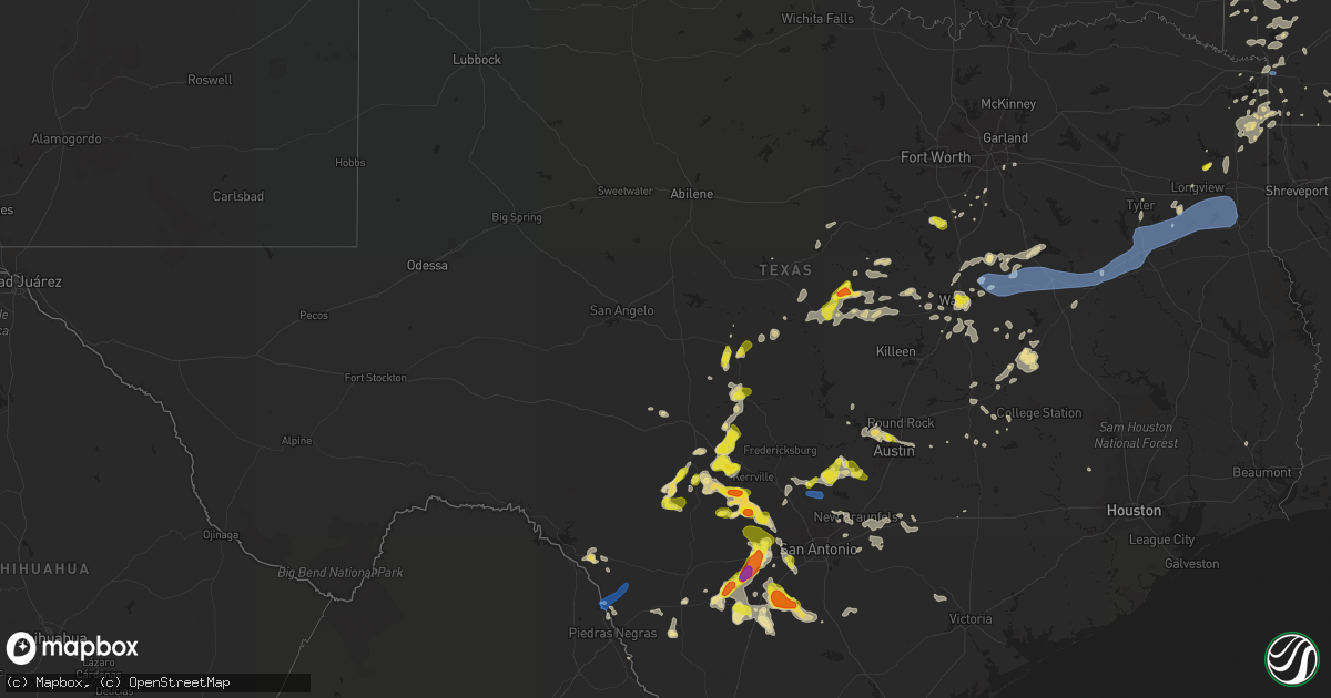
Hail Map in Texas on May 21, 2022
Get this storm
May 21 map
$229
one time, instant access
Download today. No call, no setup
Keep the $229
Bought the map and want the full workflow? Apply the entire $229 to a subscription within 7 days. None of it is wasted.
Every map, not just this one
This buys you this map. Subscription and you get every map we run, in the markets you choose from a few cities to whole states to nationwide. Plus real-time alerts the moment a storm fires.
Contact data
Name, contact info, occupancy, even credit band for addresses in the footprint. You go from where it hit to who to call.
Become the source they trust
Unlimited branding weather history reports on demand. You already have the documented answer ready for the property owner, and you are the one who showed up with it.
Property data and RoofTrace estimates
Pull up any address you have got, its value and the exact code rules for that jurisdiction, straight from One Click Code. Then RoofTrace estimates the squares, pitch, and roof value, priced the way you price.
Storm reports in Texas
Texas
| Date | Description |
|---|---|
| 05/21/20226:05 PM CDT | Cocorahs observer reports hail up to ping pong ball size. |
| 05/21/20226:05 PM CDT | Cocorahs observer reports hail up to the size of half dollars. |
| 05/21/20225:19 PM CDT | Report from mping: quarter |
| 05/21/20225:13 PM CDT | Spotter reported quarter sized hail in rio vista. |
| 05/21/20224:54 PM CDT | Cocorahs observer reports mostly dime with a few hailstones to quarter sized. |
| 05/21/20224:32 PM CDT | Spotter reported 1.6 inch hail near fm 221 and fm 2414. |
| 05/21/20223:14 PM CDT | A local report indicates 1.00 inch wind near 1 SSE MASON |
| 05/21/20226:59 AM CDT | At 1159 PM CDT, severe thunderstorms were located along a line extending from near Stephens to near Macedonia to near Vivian to near Karnack, moving southeast at 25 mph. HAZARD...60 mph wind gusts and penny size hail. SOURCE...Radar indicated. IMPACT...Expect damage to roofs, siding, and trees. Locations impacted include... El Dorado, Magnolia, Springhill, Homer, Smackover, Stamps, Waldo, Lewisville, Norphlet, Junction City, McNeil, Vivian, Blanchard, Haynesville, Benton, Cullen, Plain Dealing, Cotton Valley, Oil City and Sarepta. |
| 05/21/20225:58 AM CDT | At 1057 PM CDT, a severe thunderstorm was located over Hudson Bend, or near Anderson Mill, moving east at 10 mph. HAZARD...60 mph wind gusts and quarter size hail. SOURCE...Radar indicated. IMPACT...Hail damage to vehicles is expected. Expect wind damage to roofs, siding, and trees. Locations impacted include... Austin, Round Rock, Cedar Park, Pflugerville, Anderson Mill, Windemere, Leander, Lakeway, Lago Vista, Bee Cave, West Lake Hills, Hudson Bend, The Hills, Barton Creek, Mansfield Dam, Jonestown, Briarcliff, Point Venture, Volente and Brushy Creek. |
| 05/21/20225:55 AM CDT | At 1055 PM CDT, severe thunderstorms were located along a line extending from near Beirne to near Bivins, moving east at 30 mph. HAZARD...70 mph wind gusts and penny size hail. SOURCE...Radar indicated. IMPACT...Expect considerable tree damage. Damage is likely to mobile homes, roofs, and outbuildings. Locations impacted include... Magnolia, Hope, Atlanta, Prescott, Stamps, Waldo, Lewisville, McNeil, Vivian, Queen City, Plain Dealing, Fouke, Bradley, Taylor, Emmet, Hosston, Buckner, Perrytown, Rodessa and Rosston. |
| 05/21/20225:38 AM CDT | At 1037 PM CDT, severe thunderstorms were located along a line extending from 6 miles southeast of Lindale to near Kilgore to 9 miles southwest of Minden to Forest, moving east at 45 mph. HAZARD...60 mph wind gusts. SOURCE...Radar indicated. Trees have been downed across Southern Smith and Cherokee Counties from these storms. IMPACT...Expect damage to roofs, siding, and trees. Locations impacted include... Tyler, Longview, Nacogdoches, Marshall, Henderson, Kilgore, Carthage, White Oak, Gladewater, Center, Lindale, Hallsville, Overton, Tatum, Big Sandy, Hawkins, Tenaha, Timpson, New London and Garrison. |
| 05/21/20225:33 AM CDT | At 1033 PM CDT, a severe thunderstorm was located near Bigfoot, or 9 miles south of Devine, moving southeast at 20 mph. HAZARD...60 mph wind gusts and quarter size hail. SOURCE...Radar indicated. IMPACT...Hail damage to vehicles is expected. Expect wind damage to roofs, siding, and trees. Locations impacted include... Pleasanton, Jourdanton, Poteet, Charlotte, Bigfoot, Schattel, Iuka, Dobrowolski, Amphion, Kyote and Davis. |
| 05/21/20225:23 AM CDT | At 1023 PM CDT, severe thunderstorms were located along a line extending from 6 miles southwest of Fulton to Queen City, moving east at 15 mph. HAZARD...60 mph wind gusts and penny size hail. SOURCE...Radar indicated. IMPACT...Expect damage to roofs, siding, and trees. Locations impacted include... Texarkana, Atlanta, Wake Village, Lewisville, Nash, Queen City, Fouke, Bradley, Garland, Ogden, Mandeville, Genoa, Brightstar, Canfield, Mount Pleasant, Bloomburg, Domino, Patmos, Gin City and Piney Grove. |
| 05/21/20225:09 AM CDT | At 1009 PM CDT, a severe thunderstorm was located near Frio Town, or 10 miles northwest of Pearsall, and is nearly stationary. HAZARD...60 mph wind gusts and quarter size hail. SOURCE...Radar indicated. IMPACT...Hail damage to vehicles is expected. Expect wind damage to roofs, siding, and trees. Locations impacted include... Pearsall, Batesville, North Pearsall, Moore, Derby, Divot, Loma Vista, Bluff, Frio Town, Bigfoot and Three Oaks. |
| 05/21/20224:43 AM CDT | At 942 PM CDT, severe thunderstorms were located along a line extending from 8 miles southeast of Athens to 8 miles west of Maydelle to near Elkhart, moving east at 40 mph. HAZARD...60 mph wind gusts and penny size hail. SOURCE...Radar indicated. Numerous reports of wind damage have been reported across Anderson County with these storms, with measured wind gusts of 60 mph in Palestine. IMPACT...Expect damage to roofs, siding, and trees. Locations impacted include... Tyler, Jacksonville, Whitehouse, Rusk, Overton, Bullard, Troup, Alto, Arp, Wells, Morrill, Ponta, New Salem, Trawick, Mount Selman, Sacul, Mixon, Turnertown, Reese and Forest. |
| 05/21/20224:27 AM CDT | At 927 PM CDT, a severe thunderstorm was located just south of Kilgore, moving north at 5 mph. HAZARD...60 mph wind gusts and half dollar size hail. SOURCE...Radar indicated. IMPACT...Hail damage to vehicles is expected. Expect wind damage to roofs, siding, and trees. Locations impacted include... Longview, Kilgore, Overton, New London, Liberty City, Rolling Meadows and Laird Hill. |
| 05/21/20224:20 AM CDT | At 920 PM CDT, a severe thunderstorm was located over Kendalia, or 10 miles south of Blanco, moving east at 30 mph. HAZARD...70 mph wind gusts and quarter size hail. SOURCE...Radar indicated. IMPACT...Hail damage to vehicles is expected. Expect considerable tree damage. Wind damage is also likely to mobile homes, roofs, and outbuildings. Locations impacted include... New Braunfels, San Marcos, Schertz, Cibolo, Wimberley, Blanco, Canyon Lake Dam, Canyon Lake, Fair Oaks Ranch, Bulverde, Garden Ridge, McQueeney, Woodcreek, Santa Clara, Guadalupe River State Park, Kendalia, Smithson Valley, Spring Branch, Payton and Flugrath. |
| 05/21/20224:10 AM CDT | At 909 PM CDT, a severe thunderstorm was located near Yancey, or 16 miles south of Hondo, moving south at 10 mph. HAZARD...Ping pong ball size hail and 60 mph wind gusts. SOURCE...Radar indicated. IMPACT...People and animals outdoors will be injured. Expect hail damage to roofs, siding, windows, and vehicles. Expect wind damage to roofs, siding, and trees. Locations impacted include... Pearsall, Devine, Batesville, North Pearsall, Moore, Goldfinch, Bigfoot, Yancey, Loma Vista, Bluff, Frio Town, Schattel and Three Oaks. |
| 05/21/20224:01 AM CDT | At 900 PM CDT, severe thunderstorms were located along a line extending from Eureka to Fairfield to Buffalo, moving east at 45 mph. HAZARD...65 mph wind gusts and nickel size hail. SOURCE...Radar indicated. IMPACT...Expect damage to roofs, siding, and trees. Locations impacted include... Palestine, Buffalo, Elkhart, Frankston, Berryville, Coffee City, Fairfield Lake State Park, Oakwood, Poynor and Moore Station. |
| 05/21/20223:48 AM CDT | At 848 PM CDT, severe thunderstorms were located along a line extending from Bandera Falls to near Rio Medina to near Biry, moving east at 25 mph. HAZARD...70 mph wind gusts and ping pong ball size hail. SOURCE...Radar indicated. IMPACT...People and animals outdoors will be injured. Expect hail damage to roofs, siding, windows, and vehicles. Expect considerable tree damage. Wind damage is also likely to mobile homes, roofs, and outbuildings. Locations impacted include... San Antonio, Hondo, Devine, Castroville, Bandera, Stinson Municipal Airport, San Antonio Int Airport, Leon Valley, Helotes, Kirby, Alamo Heights, Terrell Hills, Shavano Park, Hollywood Park, Cross Mountain, Lytle, Olmos Park, Somerset, Natalia and Lacoste. |
| 05/21/20223:23 AM CDT | At 822 PM CDT, severe thunderstorms were located along a line extending from near Blooming Grove to near Coolidge to near Groesbeck, moving northeast at 35 mph. At 821 PM, 61 mph winds were observed at the Mexia airport. HAZARD...65 mph wind gusts and nickel size hail. SOURCE...Radar indicated. IMPACT...Expect damage to roofs, siding, and trees. Locations impacted include... Corsicana, Mexia, Groesbeck, Teague, Fairfield, Kerens, Wortham, Trinidad, Angus, Navarro, Fort Parker State Park, Fairfield Lake State Park, Thornton, Retreat, Oak Valley, Mildred, Eureka, Tehuacana, Richland and Streetman.This includes Interstate 45 between mile markers 181 and 235. |
| 05/21/20223:22 AM CDT | At 822 PM CDT, a severe thunderstorm was located near New Fountain, or 8 miles northeast of Hondo, moving southeast at 20 mph. HAZARD...Ping pong ball size hail and 60 mph wind gusts. SOURCE...Radar indicated. IMPACT...People and animals outdoors will be injured. Expect hail damage to roofs, siding, windows, and vehicles. Expect wind damage to roofs, siding, and trees. Locations impacted include... San Antonio, Hondo, Castroville, Lytle, Natalia, Lacoste, Cliff, Noonan, New Fountain, Quihi, Dunlay, Mico, Pearson, Rio Medina, Sea World, Bader, Hill Country State Natural Area, Government Canyon State Natural Area and Lakehills. |
| 05/21/20223:13 AM CDT | At 813 PM CDT, a severe thunderstorm was located 8 miles northwest of Tarpley, moving southeast at 10 mph. HAZARD...Quarter size hail. SOURCE...Radar indicated. IMPACT...Damage to vehicles is expected. Locations impacted include... Tarpley and Hill Country State Natural Area. |
| 05/21/20223:01 AM CDT | At 801 PM CDT, a severe thunderstorm was located near Vance, or 12 miles west of Leakey, moving southeast at 10 mph. HAZARD...60 mph wind gusts and quarter size hail. SOURCE...Radar indicated. IMPACT...Hail damage to vehicles is expected. Expect wind damage to roofs, siding, and trees. Locations impacted include... Leakey, Vance and Tuff. |
| 05/21/20223:00 AM CDT | Tree down on road. Delmar dr and lone tree rd. |
| 05/21/20222:55 AM CDT | Report of power line/power pole down at east and virginia streets. |
| 05/21/20222:55 AM CDT | At 755 PM CDT, severe thunderstorms were located along a line extending from near Camp Verde to near Medina, moving southeast at 15 mph. HAZARD...60 mph wind gusts and half dollar size hail. SOURCE...Radar indicated. IMPACT...Hail damage to vehicles is expected. Expect wind damage to roofs, siding, and trees. Locations impacted include... Medina, Bandera, Lakehills, Pipe Creek, Bandera Falls, Kronkosky State Natural Area, Hill Country State Natural Area, Mico and Lake Medina Shores. |
| 05/21/20222:51 AM CDT | At 750 PM CDT, a severe cluster of severe thunderstorms was located along a line from near Malone to east of Waco to Golinda, moving east at 30 mph. HAZARD...60 mph wind gusts and nickel size hail. SOURCE...Radar indicated. IMPACT...Expect damage to roofs, siding, and trees. Locations impacted include... Waco, Robinson, Bellmead, Mexia, Lacy-Lakeview, Groesbeck, West, Mart, Hubbard, Riesel, Coolidge, Dawson, Golinda, Hallsburg, Bynum, Fort Parker State Park, Northcrest, Frost, Abbott and Leroy.This includes Interstate 35 between mile markers 331 and 357. |
| 05/21/20222:05 AM CDT | At 704 PM CDT, a severe thunderstorm was located 11 miles northwest of Medina, moving southeast at 15 mph. HAZARD...60 mph wind gusts and half dollar size hail. SOURCE...Radar indicated. IMPACT...Hail damage to vehicles is expected. Expect wind damage to roofs, siding, and trees. Locations impacted include... Medina, Kerrville, Bandera, Center Point, Camp Verde and Kerrville-Schreiner Park. |
| 05/21/20221:58 AM CDT | At 657 PM CDT, a severe thunderstorm was located near Waco, moving north at 15 mph. Another severe storm is located near Valley Mills and is moving east at 20 mph. HAZARD...60 mph wind gusts and half dollar size hail. SOURCE...Radar indicated. IMPACT...Hail damage to vehicles is expected. Expect wind damage to roofs, siding, and trees. Locations impacted include... Waco, Hewitt, Robinson, Bellmead, Woodway, Lacy-Lakeview, McGregor, West, Beverly Hills, Valley Mills, Crawford, Hallsburg, Northcrest, Gholson, Leroy, Ross and Aquilla.This includes Interstate 35 between mile markers 325 and 356. |
| 05/21/20221:17 AM CDT | At 616 PM CDT, severe thunderstorms were located along a line extending from near Waltonia to 7 miles north of Vance, moving east at 10 mph. HAZARD...60 mph wind gusts and half dollar size hail. SOURCE...Radar indicated. IMPACT...Hail damage to vehicles is expected. Expect wind damage to roofs, siding, and trees. Locations impacted include... Kerrville, Comfort, Ingram, Hunt, Kerrville-Schreiner Park, Vance, Kerr Wildlife Management Area, Waltonia, Cypress Creek, Center Point, Mountain Home, Prade Ranch and Devil's Sinkhole State Natural Area. |
| 05/21/202212:43 AM CDT | At 543 PM CDT, a severe thunderstorm was located 5 miles southwest of Evant, or 20 miles north of Lampasas, moving east at 15 mph. HAZARD...60 mph wind gusts and quarter size hail. SOURCE...Radar indicated. IMPACT...Hail damage to vehicles is expected. Expect wind damage to roofs, siding, and trees. Locations impacted include... Evant. |
| 05/21/202212:28 AM CDT | At 528 PM CDT, a severe thunderstorm was located 11 miles west of Harper, moving northeast at 15 mph. HAZARD...60 mph wind gusts and quarter size hail. SOURCE...Radar indicated. IMPACT...Hail damage to vehicles is expected. Expect wind damage to roofs, siding, and trees. This severe thunderstorm will remain over mainly rural areas of southeastern Kimble County, including the following locations... Us-83 Near The Kerr-Kimble County Line, I-10 Near The Kimble-Kerr County Line and The Intersection Of I-10 And Us 290.This includes Interstate 10 between Mile Markers 471 and 477. |
| 05/21/202212:28 AM CDT | At 527 PM CDT, severe thunderstorms were located along a line extending from near Mountain Home to 17 miles south of Telegraph, and are nearly stationary. HAZARD...Ping pong ball size hail and 60 mph wind gusts. SOURCE...Radar indicated. IMPACT...People and animals outdoors will be injured. Expect hail damage to roofs, siding, windows, and vehicles. Expect wind damage to roofs, siding, and trees. Locations impacted include... Hunt, Mountain Home, Kerr Wildlife Management Area, Waltonia, Us- 377 Near The Kimble-Edwards County Line and Prade Ranch. |
| 05/21/202212:26 AM CDT | At 525 PM CDT, a severe thunderstorm was located 7 miles west of Cleo, or 7 miles northeast of Roosevelt, moving east at 15 mph. HAZARD...60 mph wind gusts and quarter size hail. SOURCE...Radar indicated. IMPACT...Hail damage to vehicles is expected. Expect wind damage to roofs, siding, and trees. This severe thunderstorm will remain over mainly rural areas of western Kimble and northeastern Sutton Counties, including the following locations... Cleo.This includes Interstate 10 between Mile Markers 437 and 449. |
| 05/21/202212:09 AM CDT | At 508 PM CDT, a severe thunderstorm was located near Meridian State Park, or 15 miles northwest of Clifton, moving east at 15 mph. HAZARD...Ping pong ball size hail and 60 mph wind gusts. SOURCE...Radar indicated. IMPACT...People and animals outdoors will be injured. Expect hail damage to roofs, siding, windows, and vehicles. Expect wind damage to roofs, siding, and trees. Locations impacted include... Meridian, Cranfills Gap, Meridian State Park, and Morgan. |
| 05/21/202212:05 AM CDT | At 505 PM CDT, a severe thunderstorm was located near Covington, or 10 miles southeast of Cleburne, moving east at 15 mph. HAZARD...Ping pong ball size hail and 60 mph wind gusts. SOURCE...Radar indicated. IMPACT...People and animals outdoors will be injured. Expect hail damage to roofs, siding, windows, and vehicles. Expect wind damage to roofs, siding, and trees. Locations impacted include... Itasca, Grandview, Blum, Covington and Rio Vista. This includes Interstate 35W between mile markers 4 and 21. |
| 05/20/202211:59 PM CDT | At 458 PM CDT, a severe thunderstorm was located near Goldthwaite, or 15 miles northeast of San Saba, moving east at 15 mph. HAZARD...60 mph wind gusts and half dollar size hail. SOURCE...Radar indicated. IMPACT...Hail damage to vehicles is expected. Expect wind damage to roofs, siding, and trees. Locations impacted include... Goldthwaite, Big Valley, and U.S. Highway 183 south of Goldthwaite. |
| 05/20/202211:51 PM CDT | At 451 PM CDT, severe thunderstorms were located along a line extending from 8 miles north of Mountain Home to 12 miles southeast of Telegraph, moving northeast at 10 mph. HAZARD...Golf ball size hail and 60 mph wind gusts. SOURCE...Radar indicated. IMPACT...People and animals outdoors will be injured. Expect hail damage to roofs, siding, windows, and vehicles. Expect wind damage to roofs, siding, and trees. Locations impacted include... Hunt, Mountain Home, Kerr Wildlife Management Area, Us- 83 Near The Kerr-Kimble County Line, I-10 Near The Kimble- Kerr County Line and The Intersection Of I-10 And Us 290. |
| 05/20/202211:48 PM CDT | A tree was downed on highway 43. |
| 05/20/202211:45 PM CDT | At 443 PM CDT, several severe thunderstorms area located across the county. These are moving northeast at 10 mph. HAZARD...60 mph wind gusts and half dollar size hail. SOURCE...Radar indicated. IMPACT...Hail damage to vehicles is expected. Expect wind damage to roofs, siding, and trees. Locations impacted include... Hamilton, Vista, and Lanham. |
| 05/20/202211:40 PM CDT | Trees down in the shadowood estates. |
| 05/20/202211:31 PM CDT | At 431 PM CDT, a severe thunderstorm was located near Harper, moving northeast at 25 mph. HAZARD...Ping pong ball size hail and 60 mph wind gusts. SOURCE...Radar indicated. IMPACT...People and animals outdoors will be injured. Expect hail damage to roofs, siding, windows, and vehicles. Expect wind damage to roofs, siding, and trees. This severe thunderstorm will remain over mainly rural areas of southeastern Kimble County, including the following locations... I-10 Near The Kimble-Kerr County Line. |
| 05/20/202211:29 PM CDT | At 429 PM CDT, a severe thunderstorm was located near Mason, moving northeast at 25 mph. HAZARD...60 mph wind gusts and quarter size hail. SOURCE...Radar indicated. IMPACT...Hail damage to vehicles is expected. Expect wind damage to roofs, siding, and trees. This severe thunderstorm will be near... Mason around 440 PM CDT. Hedwigs Hill around 445 PM CDT. Art around 450 PM CDT.Other locations impacted by this severe thunderstorm includeKoockville. |
| 05/20/202211:22 PM CDT | Report from mping: quarter |
| 05/20/202211:19 PM CDT | At 419 PM CDT, a severe thunderstorm was located 10 miles east of Goldthwaite, or 25 miles southwest of Hamilton, moving north at 20 mph. HAZARD...65 mph wind gusts and half dollar size hail. SOURCE...Radar indicated. IMPACT...Hail damage to vehicles is expected. Expect wind damage to roofs, siding, and trees. Locations impacted include... Goldthwaite. |
| 05/20/202211:05 PM CDT | At 404 PM CDT, severe thunderstorms were located along a line extending from 12 miles west of Doss to 9 miles northwest of Mountain Home, moving east at 10 mph. HAZARD...Ping pong ball size hail and 60 mph wind gusts. SOURCE...Radar indicated. IMPACT...People and animals outdoors will be injured. Expect hail damage to roofs, siding, windows, and vehicles. Expect wind damage to roofs, siding, and trees. Locations impacted include... Mountain Home, Doss, Harper, I-10 Near The Kimble-Kerr County Line and The Intersection Of I-10 And Us 290. |
| 05/20/202211:04 PM CDT | A tree was downed blocking fm 2011 near cr 2124d near lake cherokee. |
| 05/20/202211:03 PM CDT | At 403 PM CDT, a severe thunderstorm was located 7 miles northwest of Harper, moving northeast at 15 mph. HAZARD...Ping pong ball size hail and 60 mph wind gusts. SOURCE...Radar indicated. IMPACT...People and animals outdoors will be injured. Expect hail damage to roofs, siding, windows, and vehicles. Expect wind damage to roofs, siding, and trees. This severe thunderstorm will remain over mainly rural areas of southeastern Kimble County. |
| 05/20/202210:59 PM CDT | At 358 PM CDT, a severe thunderstorm was located 5 miles southwest of Hamilton, moving northeast at 20 mph. HAZARD...65 mph wind gusts and half dollar size hail. SOURCE...Radar indicated. IMPACT...Hail damage to vehicles is expected. Expect wind damage to roofs, siding, and trees. Locations impacted include... Hamilton. |
| 05/20/202210:39 PM CDT | At 338 PM CDT, a severe thunderstorm was located 15 miles northwest of Harper, moving northeast at 15 mph. HAZARD...60 mph wind gusts and quarter size hail. SOURCE...Radar indicated. IMPACT...Hail damage to vehicles is expected. Expect wind damage to roofs, siding, and trees. This severe thunderstorm will remain over mainly rural areas of eastern Kimble and southwestern Mason Counties. |
| 05/20/202210:38 PM CDT | Corrects previous tstm wnd dmg report from tyler. Two trees down near broadway avenue. Tree down near ut campus. |
| 05/20/202210:37 PM CDT | *** 1 inj *** vehicle collision with a tree at the intersection of sh 42 and cr 468 in w rusk county. 1 minor injury reported. |
| 05/20/202210:37 PM CDT | Trees and power lines down. |
| 05/20/202210:25 PM CDT | Two trees down near broadway avenue. Tree down near ut campus. |
| 05/20/202210:14 PM CDT | Several trees snapped. |
| 05/20/202210:12 PM CDT | At 310 PM CDT, a severe thunderstorm was located near Calf Creek, moving north at 10 mph. HAZARD...60 mph wind gusts and quarter size hail. SOURCE...Radar indicated. IMPACT...Hail damage to vehicles is expected. Expect wind damage to roofs, siding, and trees. This severe thunderstorm will be near... Brady and Brady Lake around 345 PM CDT.Other locations impacted by this severe thunderstorm include TheIntersection Of Us-190 And Ranch Road 1311. |
| 05/20/202210:04 PM CDT | At 303 PM CDT, a severe thunderstorm was located near Brady, moving northeast at 15 mph. HAZARD...Ping pong ball size hail and 60 mph wind gusts. SOURCE...Radar indicated. IMPACT...People and animals outdoors will be injured. Expect hail damage to roofs, siding, windows, and vehicles. Expect wind damage to roofs, siding, and trees. This severe thunderstorm will be near... Rochelle around 330 PM CDT. |
| 05/20/20229:41 PM CDT | Trees and power lines down. |
| 05/20/20229:37 PM CDT | At 235 PM CDT, a severe thunderstorm was located over Grit, moving northeast at 20 mph. HAZARD...60 mph wind gusts and half dollar size hail. SOURCE...Radar indicated. IMPACT...Hail damage to vehicles is expected. Expect wind damage to roofs, siding, and trees. This severe thunderstorm will be near... Mason around 245 PM CDT. Camp Air around 300 PM CDT. Katemcy around 305 PM CDT.Other locations impacted by this severe thunderstorm includeKoockville. |
| 05/20/20229:20 PM CDT | Report from mping: 3-inch tree limbs broken; power poles broken. |
| 05/20/20229:15 PM CDT | Measured 60 mph wind gust at walmart distribution center southwest of palestine. |
| 05/20/20228:40 PM CDT | Report from cocorahs observer southwest of harleton... Texas. |
| 05/20/20228:30 PM CDT | Social media report with picture. |
| 05/20/20228:25 PM CDT | Multiple trees down across park road 28 at ft. Parker state park. |
| 05/20/20228:22 PM CDT | Ktxmexia17 - adana farms weather underground station measured peak wind of 71 mph. |
| 05/20/20228:18 PM CDT | Mexia limestone county airport |
| 05/20/20228:15 PM CDT | Multiple trees down blocking roads across northeast part of limestone county. |
| 05/20/20228:06 PM CDT | Roof torn off of building under construction in coolidge. |
| 05/20/20228:05 PM CDT | Social media report of quarter to golf ball sized hail between medina and bandera. |
| 05/20/20227:40 PM CDT | Cooperative observer relayed a report of golf ball sized hail. |
| 05/20/20227:17 PM CDT | A local report indicates 1.00 inch wind near 5 SSE BELLMEAD |
| 05/20/20227:09 PM CDT | Waco regional |
| 05/20/20227:04 PM CDT | 1 inch hail near loop 340 and university parks via spotternetwork. |
All States Impacted by Hail Map on May 21, 2022
Cities Impacted by Hail Map on May 21, 2022
- Tunica, MS
- Lake Cormorant, MS
- Robinsonville, MS
- Hernando, MS
- Saint Albans, VT
- Sheldon, VT
- Swanton, VT
- Morrisville, VT
- Hyde Park, VT
- Wapakoneta, OH
- Bedford, OH
- Gates Mills, OH
- Rome, OH
- Chesterland, OH
- Orwell, OH
- Windsor, OH
- Chagrin Falls, OH
- Novelty, OH
- Macedonia, OH
- Newbury, OH
- Cleveland, OH
- Beachwood, OH
- Burton, OH
- Solon, OH
- Montville, OH
- Mentor, OH
- Willoughby, OH
- Chardon, OH
- Thompson, OH
- Huntsburg, OH
- Middlefield, OH
- Painesville, OH
- Warsaw, OH
- Columbus, OH
- Reynoldsburg, OH
- Laquey, MO
- Richland, MO
- Foster, KY
- Falmouth, KY
- Butler, KY
- Sycamore, OH
- Findlay, OH
- Carey, OH
- Upper Sandusky, OH
- Vanlue, OH
- McCutchenville, OH
- Mount Blanchard, OH
- Alvada, OH
- Arlington, OH
- New Riegel, OH
- Rock Creek, OH
- Independence, OH
- Maple Heights, OH
- Grove City, OH
- Orient, OH
- Bloomingburg, OH
- Washington Court House, OH
- Mount Sterling, OH
- London, OH
- Mount Perry, OH
- Rosebud, MO
- Gerald, MO
- Millersport, OH
- Baltimore, OH
- Central Square, NY
- Pennellville, NY
- West Monroe, NY
- Brewerton, NY
- Constantia, NY
- Saint Clair, MI
- East China, MI
- Clarks Mills, PA
- Fredonia, PA
- Greenville, PA
- Stoneboro, PA
- Conneautville, PA
- Alliance, OH
- Louisville, OH
- Ashtabula, OH
- Geneva, OH
- Austinburg, OH
- Jefferson, OH
- Parish, NY
- Clyde, OH
- Bellevue, OH
- Fresno, OH
- Errol, NH
- Canaan, VT
- Colebrook, NH
- Guildhall, VT
- Chillicothe, OH
- Circleville, OH
- Kingston, OH
- Lynn, IN
- Williamsburg, IN
- Republic, OH
- Derby Line, VT
- New Castle, IN
- Pleasantville, OH
- Russellville, OH
- Paris, KY
- Cynthiana, KY
- North Jackson, OH
- Youngstown, OH
- Lorain, OH
- Lewis, NY
- Williston, VT
- Keeseville, NY
- South Burlington, VT
- Willsboro, NY
- Shelburne, VT
- New Knoxville, OH
- Saint Marys, OH
- Forestport, NY
- Jeromesville, OH
- Mount Victory, OH
- Ridgeway, OH
- Kenton, OH
- Orleans, VT
- Almont, MI
- Flat Rock, IN
- Edinburgh, IN
- Shelbyville, IN
- Columbus, IN
- Eastlake, OH
- Derby, VT
- New Carlisle, OH
- Saint Paris, OH
- Clayton, OH
- Brookville, OH
- Dayton, OH
- North Hampton, OH
- Springfield, OH
- Englewood, OH
- Vandalia, OH
- Tipp City, OH
- Ellicottville, NY
- Franklinville, NY
- Great Valley, NY
- Pierpont, OH
- Conneaut, OH
- Kingsville, OH
- North Bloomfield, OH
- Louisville, IL
- Lake Milton, OH
- Berlin Center, OH
- Diamond, OH
- Fulton, NY
- Phoenix, NY
- Rouses Point, NY
- Centerville, IN
- Milton, IN
- Island Pond, VT
- Pittsburg, NH
- Norton, VT
- West Charleston, VT
- Averill, VT
- Andover, ME
- East Charleston, VT
- Morgan, VT
- Cuba, MO
- Atlantic, PA
- Cochranton, PA
- Meadville, PA
- Conneaut Lake, PA
- Potosi, MO
- Sullivan, MO
- House Springs, MO
- Arnold, MO
- Imperial, MO
- Fenton, MO
- High Ridge, MO
- Franklin, IN
- Trafalgar, IN
- Nineveh, IN
- Essex, NY
- West Alexandria, OH
- Sodus, NY
- Williamson, NY
- Mount Gilead, OH
- Galion, OH
- Edison, OH
- Baltic, OH
- Hillsboro, OH
- Waterford, PA
- Cambridge Springs, PA
- Germanton, NC
- Walnut Cove, NC
- Williamstown, KY
- New Wilmington, PA
- Pulaski, PA
- West Middlesex, PA
- Wirtz, VA
- Hardy, VA
- Stamping Ground, KY
- Conesville, OH
- Coshocton, OH
- Bourbon, MO
- Fincastle, VA
- Troutville, VA
- Boones Mill, VA
- Rocky Mount, VA
- O'Fallon, IL
- Belleville, IL
- Canal Winchester, OH
- Pataskala, OH
- Pickerington, OH
- Groveport, OH
- Lockbourne, OH
- Sabina, OH
- Troutdale, VA
- Sugar Grove, VA
- Burlington, KY
- Murfreesboro, NC
- Pendleton, NC
- Saint James, MO
- Saint Elmo, IL
- Troy, TN
- Hornbeak, TN
- Ridgely, TN
- Union City, TN
- Tiptonville, TN
- Obion, TN
- Williamsburg, OH
- Bethel, OH
- Frankfort, KY
- Roxboro, NC
- Timberlake, NC
- Batavia, OH
- Bahama, NC
- Imboden, AR
- Pocahontas, AR
- Greensburg, IN
- Milroy, IN
- Dover, TN
- Waverly, TN
- Hazel, KY
- Springville, TN
- Tennessee Ridge, TN
- Camden, TN
- Stewart, TN
- Mansfield, TN
- Cumberland City, TN
- Erin, TN
- Henry, TN
- Paris, TN
- Hollow Rock, TN
- New Concord, KY
- Big Sandy, TN
- Bruceton, TN
- Buchanan, TN
- Puryear, TN
- Whiteville, TN
- Iuka, IL
- Oil Trough, AR
- Pleasant Plains, AR
- Vienna, IL
- Cypress, IL
- Jonesboro, AR
- Princeton, NC
- Kenly, NC
- Selma, NC
- Canton, NC
- Waynesville, NC
- Heber Springs, AR
- McNeil, AR
- Waldo, AR
- Carlisle, AR
- Humnoke, AR
- Stuttgart, AR
- Batesville, AR
- Floral, AR
- Pulaski, TN
- Memphis, TN
- Swifton, AR
- Marshall, NC
- Louin, MS
- Cosby, TN
- Grandview, TX
- Piney Flats, TN
- Blountville, TN
- Johnson City, TN
- Kinston, AL
- Millen, GA
- Garfield, GA
- Midville, GA
- Marion, KY
- Salem, KY
- Fredonia, KY
- Burna, KY
- Eddyville, KY
- Princeton, KY
- Violet Hill, AR
- Salem, AR
- Hardy, AR
- Cherokee Village, AR
- Melbourne, AR
- Oxford, AR
- Franklin, AR
- Wiseman, AR
- Ash Flat, AR
- Glencoe, AR
- Horseshoe Bend, AR
- Brockwell, AR
- Lorena, TX
- Eva, TN
- McKenzie, TN
- Williamsville, MO
- Lewisburg, TN
- Clinton, KY
- Prospect, TN
- Lexington, NC
- Unionville, TN
- Wilburn, AR
- Saint Joe, AR
- Marshall, AR
- Oxford, NC
- Leicester, NC
- Fort Campbell, KY
- Oak Grove, KY
- Searcy, AR
- Poplar Bluff, MO
- Grandin, MO
- Ellsinore, MO
- Chuckey, TN
- Limestone, TN
- Buena Vista, TN
- Osceola, AR
- Mountain View, AR
- Pleasant Grove, AR
- Vilas, NC
- Sulphur Rock, AR
- Cord, AR
- Norman, AR
- Turbeville, SC
- Olanta, SC
- Horatio, AR
- Winthrop, AR
- Pine Bluff, AR
- McBee, SC
- Hattiesburg, MS
- Petal, MS
- Eagletown, OK
- Mena, AR
- Cabot, AR
- Cope, SC
- Anderson, AL
- Athens, AL
- Rogersville, AL
- Lester, AL
- Elkmont, AL
- Fort Mill, SC
- Kilgore, TX
- Overton, TX
- Humphrey, AR
- Aiken, SC
- Waxahachie, TX
- Hampton, AR
- Ovett, MS
- Ellisville, MS
- Hartsville, SC
- Rocky Ford, GA
- Nashville, AR
- Letohatchee, AL
- Fort Deposit, AL
- Hayneville, AL
- Springhill, LA
- West Mansfield, OH
- Mansfield, OH
- Davisburg, MI
- Shelbyville, KY
- East Carondelet, IL
- Dupo, IL
- East Saint Louis, IL
- Millstadt, IL
- Fairview Heights, IL
- Saint Louis, MO
- Petersburg, IN
- Winslow, IN
- Morehead, KY
- Carlisle, KY
- Charles City, VA
- Riner, VA
- Willis, VA
- Check, VA
- Indian Valley, VA
- Pilot, VA
- Floyd, VA
- Radford, VA
- Deerfield, OH
- Petersburg, WV
- Moorefield, WV
- Bruceville, IN
- Bicknell, IN
- Galena, MO
- Laurel Fork, VA
- Hillsville, VA
- Dickson, TN
- Burns, TN
- Danbury, NC
- Westfield, NC
- Bethel, NC
- Selmer, TN
- Ramer, TN
- Fremont, NC
- Stantonsburg, NC
- Wilson, NC
- Elkin, NC
- Roaring River, NC
- Ronda, NC
- Thurmond, NC
- State Road, NC
- North Wilkesboro, NC
- Lawrenceburg, TN
- Loretto, TN
- Leoma, TN
- Chester, SC
- Grand Junction, TN
- Michigan City, MS
- Moscow, TN
- Cordova, SC
- Texarkana, AR
- Proctor, AR
- Edmondson, AR
- Hughes, AR
- Aviston, IL
- Hot Springs Village, AR
- Lonsdale, AR
- Benton, AR
- Owensville, IN
- Princeton, IN
- Chrisney, IN
- Gentryville, IN
- Hot Springs National Park, AR
- North Tazewell, VA
- Umpire, AR
- Langley, AR
- Newhope, AR
- Jeffersonville, OH
- Wilmington, OH
- Jamestown, OH
- New Richmond, OH
- Cincinnati, OH
- Amelia, OH
- Cameron, SC
- Orangeburg, SC
- Elloree, SC
- Patriot, IN
- Rising Sun, IN
- Union, KY
- Oxford, OH
- College Corner, OH
- Somerville, OH
- Camden, OH
- Minter, AL
- Orrville, AL
- Carson, VA
- Dewitt, VA
- Dinwiddie, VA
- Saint Francisville, IL
- Lawrenceville, IL
- Sumner, IL
- Bridgeport, IL
- Claremont, IL
- Lansing, NC
- Creston, NC
- Greenfield, OH
- Leesburg, OH
- Marion, VA
- Suffolk, VA
- Sparta, KY
- Warsaw, KY
- Glencoe, KY
- Carlyle, IL
- Lawrenceburg, KY
- Locust Grove, AR
- Rosie, AR
- Sardinia, OH
- Lynchburg, OH
- Mount Orab, OH
- Elk Horn, KY
- Cecilia, KY
- Glendale, KY
- Linesville, PA
- Andover, OH
- Dorset, OH
- Drummonds, TN
- North Little Rock, AR
- Little Rock, AR
- Sunbury, OH
- Centerburg, OH
- Liberty, KY
- Success, AR
- Felicity, OH
- Ozan, AR
- Mineral Springs, AR
- Lockesburg, AR
- Columbus, AR
- Dittmer, MO
- Catawissa, MO
- Hillsboro, MO
- Pacific, MO
- Robertsville, MO
- Richwoods, MO
- Eureka, MO
- Cedar Hill, MO
- Guion, AR
- Mount Pleasant, AR
- Fulton, AR
- Ashdown, AR
- Meridian, MS
- Ore City, TX
- Blytheville, AR
- Safford, AL
- Dyer, TN
- Trenton, TN
- Martin, TN
- Ravenden Springs, AR
- Warm Springs, AR
- Goldsboro, NC
- Crawfordsville, AR
- Marion, AR
- Wakefield, VA
- Carrsville, VA
- Franklin, VA
- Zuni, VA
- Sedley, VA
- Courtland, VA
- Ivor, VA
- Hagarville, AR
- Dover, AR
- Compton, AR
- Lamar, AR
- Clarksville, AR
- Somerville, TN
- New London, NC
- Mount Pleasant, NC
- Albemarle, NC
- Dierks, AR
- Augusta, AR
- Bald Knob, AR
- Summerton, SC
- Rosston, AR
- Conway, AR
- Bigelow, AR
- Hot Springs, NC
- Stephens, AR
- Magnolia, AR
- Marked Tree, AR
- Lepanto, AR
- Jackman, ME
- Robards, KY
- Newark, AR
- Corydon, KY
- Henderson, KY
- Perryville, AR
- Roland, AR
- Paron, AR
- Jessieville, AR
- Elizabethtown, KY
- Manilla, IN
- Columbia, SC
- Tuscola, IL
- Seaman, OH
- Winchester, OH
- Georgetown, OH
- Iron City, TN
- Florence, AL
- Madisonville, KY
- Nortonville, KY
- White Plains, KY
- Graham, KY
- Earlington, KY
- Mortons Gap, KY
- Hatfield, AR
- Toomsuba, MS
- Frankfort, OH
- Nebo, KY
- Manitou, KY
- Livingston, AL
- Emelle, AL
- Princeton, WV
- South Salem, OH
- Dale, IN
- Lincoln City, IN
- Stendal, IN
- Boonville, IN
- Tennyson, IN
- Wickliffe, OH
- Rougemont, NC
- Aulander, NC
- Morgantown, IN
- Nashville, IN
- Whitetop, VA
- Mouth Of Wilson, VA
- Makanda, IL
- Cobden, IL
- Goreville, IL
- Carbondale, IL
- Hampshire, TN
- Scott City, MO
- Benton, MO
- Oran, MO
- Thebes, IL
- Chaffee, MO
- Culleoka, TN
- Thompsons Station, TN
- College Grove, TN
- Franklin, TN
- China Grove, NC
- Landis, NC
- Kannapolis, NC
- Centerville, TN
- Evansville, IN
- Blair, SC
- Hooks, TX
- Doniphan, MO
- Brecksville, OH
- Northfield, OH
- Johnson, VT
- Afton, TN
- Greeneville, TN
- Scott, AR
- Huntsville, OH
- Rushsylvania, OH
- Belle Center, OH
- Bellefontaine, OH
- Arcanum, OH
- West Milton, OH
- Laura, OH
- Ludlow Falls, OH
- Corinth, MS
- Huntsville, AR
- Berryville, AR
- Kosse, TX
- Marlin, TX
- Benton, LA
- Belcher, LA
- Como, NC
- Witter, AR
- State Line, MS
- Crestline, OH
- Tiro, OH
- Bentonia, MS
- Canton, MS
- Vaughan, MS
- Flag Pond, TN
- Fouke, AR
- West Memphis, AR
- New Haven, MI
- Macomb, MI
- New Baltimore, MI
- Jackson, TN
- Kirby, AR
- North Troy, VT
- Newport Center, VT
- Newport, VT
- Cherokee, AL
- Barton, VT
- Caseyville, IL
- Midlothian, TX
- Thornton, TX
- Hanson, KY
- Sebree, KY
- Slaughters, KY
- Hamilton, TX
- Jonesboro, TX
- Clifton, TX
- Cranfills Gap, TX
- Hico, TX
- Patton, MO
- Russia, OH
- Eaton, OH
- West Manchester, OH
- Covington, OH
- Fort Loramie, OH
- New Paris, OH
- Greenville, OH
- Pitsburg, OH
- Lewisburg, OH
- Eldorado, OH
- Richmond, IN
- Fountain City, IN
- New Madison, OH
- Palestine, OH
- Versailles, OH
- Hollansburg, OH
- Sidney, OH
- Piqua, OH
- Gettysburg, OH
- Bradford, OH
- Houston, OH
- Douglassville, TX
- Advance, MO
- Solsberry, IN
- Spencer, IN
- Tiffin, OH
- Bloomville, OH
- Saint Regis Falls, NY
- Potsdam, NY
- Bardstown, KY
- Bloomfield, KY
- Mineral Point, MO
- Valley Head, WV
- Durham, NC
- Hillsborough, NC
- Smithfield, VA
- Georgetown, KY
- Green Forest, AR
- Rushville, IN
- Finchville, KY
- Fisherville, KY
- Henrico, NC
- Valentines, VA
- Lenoir, NC
- Dongola, IL
- Buncombe, IL
- Marengo, OH
- Fulton, OH
- Ashley, OH
- Cardington, OH
- Summertown, TN
- Ethridge, TN
- Cottage Grove, TN
- Corning, AR
- Mountain Pine, AR
- King, NC
- Newberry, SC
- Scottsboro, AL
- Dyersburg, TN
- Newbern, TN
- Brickeys, AR
- Amity, AR
- Glenwood, AR
- Claudville, VA
- Mount Airy, NC
- Ararat, VA
- Pomaria, SC
- Cayce, SC
- Gaston, SC
- Hopkins, SC
- West Columbia, SC
- Maynard, AR
- Walls, MS
- Mullin, TX
- Eddy, TX
- Clayton Lake, ME
- Enosburg Falls, VT
- Berlin, NH
- Lobelville, TN
- Oakboro, NC
- Jasper, AR
- Spring Lake, NC
- Dyess, AR
- Tyronza, AR
- Goodspring, TN
- Waldron, IN
- Saint Joseph, TN
- Killen, AL
- Five Points, TN
- Muscle Shoals, AL
- Minor Hill, TN
- Lexington, AL
- Watson, OK
- Laurinburg, NC
- Gibson, NC
- McColl, SC
- Clio, SC
- Maxton, NC
- Little Rock, SC
- Horse Cave, KY
- Cave City, KY
- Tallassee, AL
- Decatur, MS
- Hickory, MS
- Enterprise, MS
- Rose Hill, MS
- Newton, MS
- Quitman, MS
- Stonewall, MS
- Pachuta, MS
- Modoc, IN
- Hagerstown, IN
- Economy, IN
- Spiceland, IN
- Knightstown, IN
- Rockport, IN
- Shady Valley, TN
- Rural Retreat, VA
- Windsor, VA
- Trimble, TN
- Kenton, TN
- Duck River, TN
- Hohenwald, TN
- Linden, TN
- Tarboro, NC
- Greenville, NC
- Salisbury, NC
- Adamsville, TN
- Crump, TN
- Ratcliff, AR
- Cardwell, MO
- Arbyrd, MO
- Columbia, TN
- Algonac, MI
- Fair Haven, MI
- Marine City, MI
- Harsens Island, MI
- London, AR
- Russellville, AR
- Delaware, AR
- Carroll, OH
- Rock Hill, SC
- Caddo Gap, AR
- Carlisle, SC
- Homer, IN
- Arlington, IN
- Morristown, IN
- Winnsboro, SC
- Richland Springs, TX
- San Saba, TX
- Marshall, TX
- Harleton, TX
- Jefferson, TX
- Highgate Center, VT
- Alburgh, VT
- Franklin, VT
- Clarksburg, OH
- New Holland, OH
- Williamsport, OH
- Newport, PA
- Millerstown, PA
- Ickesburg, PA
- Elliottsburg, PA
- Cook Sta, MO
- Steelville, MO
- Jonesborough, TN
- Telford, TN
- Lilbourn, MO
- Parma, MO
- Huntingdon, TN
- Greenbrier, AR
- Morrilton, AR
- Plumerville, AR
- Springfield, AR
- Solgohachia, AR
- Damascus, AR
- Troy, OH
- Holland, IN
- Huntingburg, IN
- Lawrenceville, VA
- Edgemont, AR
- Tumbling Shoals, AR
- Fairfield Bay, AR
- Prim, AR
- Drasco, AR
- Higden, AR
- Ida, AR
- Shirley, AR
- Concord, AR
- Greenfield, TN
- Gleason, TN
- Dresden, TN
- Mount Pleasant, TN
- Olive Hill, KY
- Maumelle, AR
- Little Rock Air Force Base, AR
- El Paso, AR
- Vilonia, AR
- Mayflower, AR
- Jacksonville, AR
- Sherwood, AR
- Spring Hill, TN
- Lewisville, IN
- Falmouth, IN
- Shelbyville, TN
- Poseyville, IN
- New Harmony, IN
- Wadesville, IN
- Mount Vernon, IN
- Cullowhee, NC
- Smithfield, NC
- Clayton, NC
- Taylorsville, KY
- Parsons, TN
- Decaturville, TN
- Munford, TN
- Millington, TN
- Saltillo, MS
- Baldwyn, MS
- New Albany, MS
- Blue Springs, MS
- Guntown, MS
- Tionesta, PA
- Marienville, PA
- Walton, KY
- Darlington, SC
- Midway, KY
- Murfreesboro, AR
- Newberry, IN
- Springville, IN
- Bloomfield, IN
- Owensburg, IN
- Scotland, IN
- Bishopville, SC
- Coldwater, MS
- Columbia, IL
- Valmeyer, IL
- De Queen, AR
- Kershaw, SC
- Texarkana, TX
- Queen City, TX
- Brownstown, IL
- Moro, AR
- Junction City, AR
- El Dorado, AR
- Connersville, IN
- Glenwood, IN
- Brownsville, IN
- Damascus, VA
- Chilhowie, VA
- Laurel Bloomery, TN
- Atlanta, TX
- Bloomburg, TX
- Bivins, TX
- Doddridge, AR
- Linden, TX
- Brownsboro, AL
- Huntsville, AL
- Owens Cross Roads, AL
- Dolphin, VA
- Rogersville, MO
- Fordland, MO
- Selma, AL
- Tyler, AL
- Freeman, VA
- Warfield, VA
- Spruce Pine, NC
- Marion, NC
- Elkton, KY
- Shell Knob, MO
- Blue Eye, MO
- Lampe, MO
- Deer, AR
- Polkton, NC
- Peachland, NC
- Charlotte, NC
- Sheridan, AR
- Redfield, AR
- Timbo, AR
- Fox, AR
- Windsor, NC
- Leesville, SC
- Batesburg, SC
- Alexander, AR
- Saratoga, AR
- New Edinburg, AR
- Neeses, SC
- Royal, AR
- Bonnerdale, AR
- Marshville, NC
- Hope, AR
- Manning, SC
- Dublin, TX
- Stephenville, TX
- Milan, GA
- Jacksonville, GA
- Rhine, GA
- Chilton, TX
- Peterman, AL
- McKenzie, AL
- Evergreen, AL
- Bainbridge, OH
- Highland, IL
- Saint Jacob, IL
- Marine, IL
- Smithland, KY
- Yorktown, VA
- Surry, VA
- Fort Eustis, VA
- Newport News, VA
- Hayes, VA
- Gloucester Point, VA
- Williamsburg, VA
- Norfork, AR
- Calico Rock, AR
- Flippin, AR
- Mountain Home, AR
- Quitman, AR
- Lynnville, TN
- Etowah, AR
- Newport, AR
- Tuckerman, AR
- Del Rio, TN
- Hartford, TN
- Newport, TN
- Portageville, MO
- Hayti, MO
- Eureka Springs, AR
- Bridgeport, AL
- Richburg, SC
- Great Falls, SC
- Pearcy, AR
- Bismarck, AR
- Whitmire, SC
- Hephzibah, GA
- Eutaw, AL
- Adrian, GA
- Soperton, GA
- Lancaster, NH
- Boonville, NY
- Port Leyden, NY
- Constableville, NY
- Lima, OH
- Bucyrus, OH
- Caledonia, OH
- Harrison Township, MI
- Ashville, OH
- Loveland, OH
- Pleasant Plain, OH
- Maineville, OH
- Ft Mitchell, KY
- Clarksville, OH
- Morrow, OH
- Latonia, KY
- Blanchester, OH
- Newport, KY
- Martinsville, OH
- Midland, OH
- Fort Thomas, KY
- Goshen, OH
- New Vienna, OH
- Milford, OH
- Maplewood, OH
- Jackson Center, OH
- Lakeview, OH
- Lewistown, OH
- Waddy, KY
- Edwardsport, IN
- California, KY
- Alexandria, KY
- Caledonia, MO
- Belleview, MO
- Belgrade, MO
- Roseland, VA
- Lovingston, VA
- Brenton, WV
- Bagdad, KY
- Munfordville, KY
- Hiwassee, VA
- Dugspur, VA
- Mount Eden, KY
- Roanoke, VA
- West Forks, ME
- Vienna, OH
- Niles, OH
- Girard, OH
- Worthington, IN
- Hymera, IN
- Shelburn, IN
- Coalmont, IN
- Coal City, IN
- Jasonville, IN
- Lewis, IN
- Freedom, IN
- Sullivan, IN
- Clay City, IN
- Mountain City, TN
- Smithville, AR
- Strawberry, AR
- Poughkeepsie, AR
- Ravenden, AR
- Black Rock, AR
- Evening Shade, AR
- Williford, AR
- McEwen, TN
- Brookport, IL
- Golconda, IL
- Plymouth, OH
- Willard, OH
- Monroeville, OH
- Attica, OH
- New Washington, OH
- Ontario, NY
- Stuart, VA
- Bethpage, TN
- Gallatin, TN
- Mammoth Spring, AR
- Liberty, IN
- Brookville, IN
- Apex, NC
- Cary, NC
- Morrisville, NC
- Pettigrew, AR
- Kansas, OK
- Delphos, OH
- Pandora, OH
- Forest, OH
- Columbus Grove, OH
- Cairo, OH
- Mount Cory, OH
- Bluffton, OH
- Jenera, OH
- Rawson, OH
- Spencerville, OH
- Ada, OH
- Mason, TN
- La Crosse, VA
- Brodnax, VA
- Williamsport, TN
- Edgemoor, SC
- Delaplaine, AR
- Hoxie, AR
- Peach Orchard, AR
- Marmaduke, AR
- Alicia, AR
- Knobel, AR
- Paragould, AR
- Bono, AR
- Walnut Ridge, AR
- Beech Grove, AR
- Piggott, AR
- Biggers, AR
- Lafe, AR
- Rector, AR
- Cash, AR
- O'Kean, AR
- Yadkinville, NC
- Mocksville, NC
- Stamps, AR
- Taylor, AR
- Fall Branch, TN
- Franklin, TX
- Cooter, MO
- Saint Francis, AR
- Gobler, MO
- Caruthersville, MO
- Holcomb, MO
- Catron, MO
- Senath, MO
- Bragg City, MO
- Wardell, MO
- Finley, TN
- Kennett, MO
- Steele, MO
- Clarkton, MO
- Campbell, MO
- Malden, MO
- Greenway, AR
- Hornersville, MO
- Gideon, MO
- Manila, AR
- Leachville, AR
- Lenox, TN
- Forsyth, GA
- Nashville, IL
- Dresden, OH
- South Boston, VA
- Yanceyville, NC
- Burlington, NC
- Byhalia, MS
- Holly Springs, MS
- Red Banks, MS
- Rutherford, TN
- Prescott, AR
- Mayfield, KY
- Lynchburg, SC
- Hickman, KY
- New Madrid, MO
- Rives, TN
- East Prairie, MO
- Marston, MO
- Seminary, MS
- Jerusalem, AR
- Cleveland, AR
- New Blaine, AR
- Witts Springs, AR
- Scranton, AR
- Atkins, AR
- Clinton, AR
- Dennard, AR
- Choctaw, AR
- Center Ridge, AR
- Pelsor, AR
- Bee Branch, AR
- Hattieville, AR
- Hector, AR
- Leslie, AR
- Tilly, AR
- Scotland, AR
- Ozone, AR
- Stanton, TN
- Beebe, AR
- Northport, AL
- Oakman, AL
- Brookwood, AL
- Quinton, AL
- Bessemer, AL
- Adger, AL
- Norwood, NC
- Waco, TX
- Jackson, AL
- Frenchmans Bayou, AR
- Arlington, TN
- Turrell, AR
- Vandervoort, AR
- Cove, AR
- Wickes, AR
- Elgin, SC
- Fairfax, SC
- Allendale, SC
- Ozark, IL
- West Harrison, IN
- New Trenton, IN
- Cedar Grove, IN
- Madison, IN
- Blackwell, MO
- Fletcher, MO
- Amherst, VA
- Alexandria, OH
- Granville, OH
- Perrysville, OH
- Butler, OH
- Mercer, PA
- Owensville, MO
- Bland, MO
- Belle, MO
- Grundy, VA
- Big Rock, VA
- Bell City, MO
- Chaplin, KY
- Nunda, NY
- Portageville, NY
- Fillmore, NY
- Dalton, NY
- Hunt, NY
- Bismarck, MO
- Irondale, MO
- Lawsonville, NC
- Kevil, KY
- Metropolis, IL
- Melber, KY
- Paducah, KY
- Hickory, KY
- Symsonia, KY
- Arlington, KY
- Bardwell, KY
- West Paducah, KY
- Fancy Farm, KY
- Cunningham, KY
- Wickliffe, KY
- La Center, KY
- Ledbetter, KY
- Barlow, KY
- Boaz, KY
- Trenton, KY
- Mount Judea, AR
- Clyde, NC
- Newburg, MO
- West College Corner, IN
- Meridian, TX
- Iredell, TX
- Waynesfield, OH
- Twin City, GA
- Palestine, TX
- Richmond, MI
- Casco, MI
- Corry, PA
- Corinth, KY
- Owenton, KY
- Jamestown, PA
- Kinsman, OH
- Milan, NH
- Miller City, IL
- Union City, PA
- Glenford, OH
- Somerset, OH
- Thornville, OH
- Matthews, MO
- Hamersville, OH
- Sharon, TN
- Grandview, IN
- Evanston, IN
- Lamar, IN
- Augusta, KY
- Vendor, AR
- Parthenon, AR
- Hasty, AR
- Western Grove, AR
- Reagan, TN
- Enville, TN
- Milledgeville, TN
- Sardis, TN
- Bath Springs, TN
- Scotts Hill, TN
- Saltillo, TN
- Pocahontas, TN
- Wilson, AR
- Joiner, AR
- Houston, AR
- England, AR
- Hensley, AR
- Comanche, TX
- Nesbit, MS
- Thomasville, AL
- Sweet Water, AL
- Doyline, LA
- Sibley, LA
- Valley Mills, TX
- Crawford, TX
- Riesel, TX
- Evant, TX
- Lometa, TX
- Purmela, TX
- Goldthwaite, TX
- Gatesville, TX
- Lampasas, TX
- Star, TX
- Denmark, SC
- Bamberg, SC
- Catherine, AL
- McGregor, TX
- Camden, AL
- Rowesville, SC
- Branchville, SC
- Caldwell, TX
- Gainesville, AL
- Epes, AL
- Dallas, TX
- Marietta, TX
- Mexia, TX
- Wortham, TX
- Mart, TX
- Axtell, TX
- Moody, TX
- Diana, TX
- May, TX
- Mount Calm, TX
- Prairie Hill, TX
- Rodessa, LA
- Ida, LA
- Lohn, TX
- Lott, TX
- Reagan, TX
- Rosebud, TX
- Maypearl, TX
- Tyler, TX
- Whitehouse, TX
- Collins, MS
- Plain Dealing, LA
- Macon, GA
- Dry Branch, GA
- Eatonton, GA
- Forest Home, AL
- McRae Helena, GA
- Woodway, TX
- Musella, GA
- Roberta, GA
- Knoxville, GA
- Leakesville, MS
- New Augusta, MS
- Richton, MS
- Bradley, AR
- Longview, TX
- Alberta, AL
- Vinegar Bend, AL
- Buckner, AR
- Italy, TX
- Mize, MS
- Seagoville, TX
- Mesquite, TX
- Bay Springs, MS
- Brooker, FL
- Gause, TX
- Sterrett, AL
- Vincent, AL
- Chelsea, AL
- Wilsonville, AL
- Columbiana, AL
- Harpersville, AL
- Lauderdale, MS
- Pine Apple, AL
- Moselle, MS
- Hosston, LA
- Spicewood, TX
- Hockley, TX
- Boerne, TX
- West, TX
- Elm Mott, TX
- Cadwell, GA
- Falls City, TX
- Smackover, AR
- Monticello, GA
- Quemado, TX
- Bertram, TX
- Burnet, TX
- Perkinston, MS
- Yulee, FL
- Moore, TX
- Devine, TX
- Charlotte, TX
- Bigfoot, TX
- Pearsall, TX
- Jourdanton, TX
- Pleasanton, TX
- McDade, TX
- Del Rio, TX
- Laughlin Afb, TX
- Brackettville, TX
- Brooksville, FL
- Leakey, TX
- Punta Gorda, FL
- Arcadia, FL
- Sonora, TX
- Lake City, FL
- Wellborn, FL
- McAlpin, FL
- Lumberton, MS
- Luling, TX
- Brady, TX
- Plant City, FL
- Gainesville, FL
- Bay Minette, AL
- Pierson, FL
- Bunnell, FL
- Seville, FL
- Comfort, TX
- Lakeland, FL
- Bartow, FL
- Fort Meade, FL
- Ehrhardt, SC
- Hubbard, TX
- Dawson, TX
- Oviedo, FL
- Hunt, TX
- Kendalia, TX
- Medina, TX
- Leesburg, FL
- Clermont, FL
- Tavares, FL
- Howey In The Hills, FL
- Astatula, FL
- Mount Dora, FL
- La Coste, TX
- San Antonio, TX
- Lytle, TX
- Somerset, TX
- Castroville, TX
- Atascosa, TX
- Hearne, TX
- Calvert, TX
- Cameron, TX
- Junction, TX
- Saint Johns, FL
- Orange City, FL
- De Leon Springs, FL
- Deland, FL
- Mountain Home, TX
- Harper, TX
- Mason, TX
- Flatonia, TX
- Lewisville, AR
- Jacksonville, FL
- Milano, TX
- Dime Box, TX
- Giddings, TX
- Green Cove Springs, FL
- Gloster, MS
- Centreville, MS
- Saint Francisville, LA
- Woodville, MS
- Eustis, FL
- Geneva, FL
- Orlando, FL
- Marble Falls, TX
- Austin, TX
- Leander, TX
- Sorrento, FL
- Saint Augustine, FL
- La Pryor, TX
- Alva, FL
- Johnson City, TX
- Blanco, TX
- Dripping Springs, TX
- Wimberley, TX
- Crystal City, TX
- Camp Wood, TX
- Bandera, TX
- Utopia, TX
- Hondo, TX
- Batesville, TX
- D Hanis, TX
- Yancey, TX
- Barksdale, TX
- Rocksprings, TX
- Manor, TX
- Kountze, TX
- Myakka City, FL
- Lodge, SC
- Harwood, TX
- Lake Butler, FL
- Jasper, FL
- Ingram, TX
- New Braunfels, TX
- McQueeney, TX
- Kingsbury, TX
- Seguin, TX
- Richland, TX
- Corsicana, TX
- Rockdale, TX
- Lincoln, TX
- Baker, LA
- Baton Rouge, LA
- Spring Branch, TX
- Tuskegee, AL
- Hardaway, AL
- Jayess, MS
- Tylertown, MS
- Live Oak, FL
- White Springs, FL
- Mico, TX
- Pipe Creek, TX
- Tarpley, TX
- Kerrville, TX
- Vanderpool, TX
- O'Brien, FL
- Mount Hermon, LA
- Franklinton, LA
- Lexington, TX
- Orange Park, FL
- Middleburg, FL
- Blum, TX
- Covington, TX
- Rio Vista, TX
- Cleburne, TX
- Penelope, TX
- Purdon, TX
- Coolidge, TX
- Abbott, TX
- Oakwood, TX
- Buffalo, TX
- Fischer, TX
- Driftwood, TX
- Eagle Pass, TX
- Cibolo, TX
- Schertz, TX
- Laredo, TX
- Bryan, TX
- Concepcion, TX
- Robstown, TX
- Corpus Christi, TX
- Mathis, TX
- Sanford, FL
- Winter Springs, FL
- Dade City, FL
- Webster, FL
- Marion, TX
- Bulverde, TX
- Beaumont, MS
- Okeechobee, FL
- Winter Garden, FL
- Polk City, FL
- Bowling Green, FL
- Dilley, TX
- Zolfo Springs, FL
- Denham Springs, LA
- Brewton, AL
- Hext, TX
- Menard, TX
- Deltona, FL
- Spring Hill, FL
- Bradley, FL
- Hampton, FL
- Starke, FL
- La Vernia, TX
- Gonzales, TX
- Walker, LA
- Wauchula, FL
- Ona, FL
- Cuero, TX
- Elgin, TX
- Palatka, FL
- Rio Medina, TX
- Hawthorne, FL
- Muldoon, TX
- Schulenburg, TX
- Ormond Beach, FL
- Daytona Beach, FL
- Mineral Ridge, OH
- Altamont, IL
- Jacksonville Beach, FL
- Pine Level, NC
- Fairfield, TX
- Troup, TX
- Bullard, TX
- Rusk, TX
- Teague, TX
- Hallsville, TX
- Tennessee Colony, TX
- Jacksonville, TX
- Tatum, TX
- Carthage, TX
- Groesbeck, TX
- Selman City, TX
- Streetman, TX
- Price, TX
- Henderson, TX
- Beckville, TX
- Bergheim, TX
- Ponca, AR
- Mulga, AL
- Lyons Falls, NY
- Mooers Forks, NY
- North Rose, NY
- Martville, NY
- Red Creek, NY
- Lyons, NY
- Newark, NY
- Walworth, NY
- Marion, NY
- Clyde, NY
- Wolcott, NY
- Sterling, NY
- Harrisburg, OH
- Hiram, OH
- Warren, OH
- Southington, OH
- Adamsville, PA
- Streetsboro, OH
- Williamsfield, OH
- Farmdale, OH
- Fowler, OH
- Aurora, OH
- Twinsburg, OH
- Garrettsville, OH
- Hartstown, PA
- Mantua, OH
- Bristolville, OH
- Cortland, OH
- West Farmington, OH
- Transfer, PA
- Burghill, OH
- Windham, OH
- Hermitage, PA
- Brookfield, OH
- Wheatland, PA
- Sharon, PA
- Sharpsville, PA
- Masury, OH
- Hubbard, OH
- Farrell, PA
- Ewing, VA
- Jonesville, VA
- Rose Hill, VA
- Cooperstown, PA
- Oil City, PA
- Spartansburg, PA
- Pleasantville, PA
- Utica, PA
- Hydetown, PA
- Townville, PA
- Titusville, PA
- Centerville, PA
- Grand Valley, PA
- Carlton, PA
- Guys Mills, PA
- Tidioute, PA
- Pittsfield, PA
- Franklin, PA
- Spring Creek, PA
- Sandy Lake, PA
- Polk, PA
- Trumann, AR
- Austin, AR
- Martinsville, IN
- Paragon, IN
- Okeana, OH
- Sneedville, TN
- Golden Gate, IL
- Grayville, IL
- Barnhill, IL
- Fairfield, IL
- Albion, IL
- Celestine, IN
- Ferdinand, IN
- Saint Meinrad, IN
- Eckerty, IN
- Leopold, IN
- Schnellville, IN
- Dubois, IN
- Santa Claus, IN
- Sulphur, IN
- Leavenworth, IN
- Grantsburg, IN
- Branchville, IN
- English, IN
- Saint Croix, IN
- Jasper, IN
- Saint Anthony, IN
- Bristow, IN
- Birdseye, IN
- Taswell, IN
- Fairfield, OH
- Oldenburg, IN
- Seven Mile, OH
- Sunman, IN
- Hamilton, OH
- Clifford, IN
- Westport, IN
- Trenton, OH
- Hartsville, IN
- Batesville, IN
- Butlerville, IN
- Laurel, IN
- Cleves, OH
- Metamora, IN
- Bath, IN
- Harrison, OH
- Hope, IN
- Middletown, OH
- Saint Paul, IN
- Taylorsville, IN
- Osgood, IN
- Boston, IN
- Leasburg, MO
- Henning, TN
- Lake City, AR
- State University, AR
- Black Oak, AR
- Monette, AR
- Portia, AR
- Harrisburg, AR
- Bassett, AR
- Powhatan, AR
- Brookland, AR
- Sidney, AR
- Keiser, AR
- Caraway, AR
- Dell, AR
- Cave City, AR
- Gilmore, AR
- Lynn, AR
- Luxora, AR
- Saffell, AR
- Burlison, TN
- Weiner, AR
- Bay, AR
- Hazen, AR
- Lonoke, AR
- Grady, AR
- Yorktown, AR
- Star City, AR
- Kingsland, AR
- Monticello, AR
- Thornton, AR
- Rison, AR
- Warren, AR
- Banks, AR
- Fordyce, AR
- Wilmar, AR
- Ivan, AR
- De Witt, AR
- Almyra, AR
- Altheimer, AR
- Wabbaseka, AR
- Rochelle, TX
- Itasca, TX


