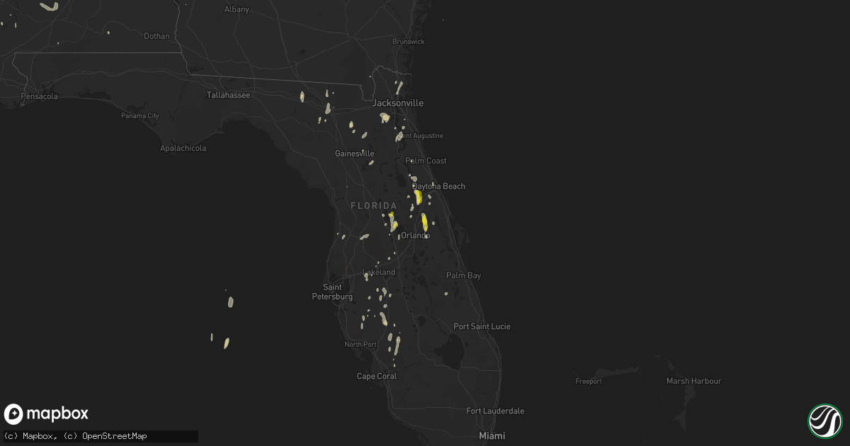
Hail Map on May 21, 2022
Get this storm
May 21 map
$229
one time, instant access
Download today. No call, no setup
Keep the $229
Bought the map and want the full workflow? Apply the entire $229 to a subscription within 7 days. None of it is wasted.
Every map, not just this one
This buys you this map. Subscription and you get every map we run, in the markets you choose from a few cities to whole states to nationwide. Plus real-time alerts the moment a storm fires.
Contact data
Name, contact info, occupancy, even credit band for addresses in the footprint. You go from where it hit to who to call.
Become the source they trust
Unlimited branding weather history reports on demand. You already have the documented answer ready for the property owner, and you are the one who showed up with it.
Property data and RoofTrace estimates
Pull up any address you have got, its value and the exact code rules for that jurisdiction, straight from One Click Code. Then RoofTrace estimates the squares, pitch, and roof value, priced the way you price.
States Impacted by Hail Map on May 21, 2022
Storm reports
Georgia
| Date | Description |
|---|---|
| 05/21/20221:10 AM CDT | At 610 PM EDT, a severe thunderstorm was located over Suwannee River State Park, moving north at 20 mph. HAZARD...60 mph wind gusts and quarter size hail. SOURCE...Radar indicated. IMPACT...Hail damage to vehicles is expected. Expect wind damage to roofs, siding, and trees. Locations impacted include... Jasper, Jennings, Suwannee River State Park and Crossroads. |
| 05/20/202211:57 PM CDT | At 457 PM EDT, a severe thunderstorm was located over Oceanway, or near Jacksonville International Arpt, moving northeast at 15 mph. HAZARD...60 mph wind gusts and quarter size hail. SOURCE...Radar indicated. IMPACT...Hail damage to vehicles is expected. Expect wind damage to roofs, siding, and trees. Locations impacted include... St. Marys, Kingsland, Kings Bay Base, Jacksonville International Arpt, Yulee, Oceanway, Cisco Gardens and Tallyrand. |
Pennsylvania
| Date | Description |
|---|---|
| 05/21/20226:55 PM CDT | Numerous trees down around valley view road. |
| 05/21/20226:55 PM CDT | Shingle damage to a garage; picture provided. |
| 05/21/20226:35 PM CDT | Two large trees snapped on mcclain road |
| 05/21/20226:35 PM CDT | Multiple trees down in town. Time estimated from radar. |
| 05/21/20224:56 PM CDT | Several trees down. Pea size hail also. Time estimated from radar. |
| 05/21/20223:21 AM CDT | At 821 PM EDT, severe thunderstorms were located along a line extending from 6 miles northwest of Sugarcreek to 10 miles east of Grove City, moving northeast at 45 mph. HAZARD...60 mph wind gusts and quarter size hail. SOURCE...Radar indicated. IMPACT...Minor hail damage to vehicles is possible. Expect wind damage to trees and power lines, resulting in some power outages. Locations impacted include... Oil City, Franklin, Knox, Sugarcreek, Shanor-Northvue, Hasson Heights, Seneca, Parker, Polk, Emlenton, Bruin, and Rouseville. |
| 05/21/20223:09 AM CDT | At 809 PM EDT, severe thunderstorms were located along a line extending from near Cranberry to Bridgeville, moving east at 45 mph. HAZARD...60 mph wind gusts and penny size hail. SOURCE...Radar indicated. IMPACT...Expect damage to trees and power lines, resulting in some power outages. Locations impacted include... Pittsburgh, Penn Hills, Mount Lebanon, Bethel Park, Ross Township, McCandless Township, Monroeville, Cranberry, McKeesport, Franklin Park, Shaler Township, and Plum. |
| 05/21/20223:08 AM CDT | At 808 PM EDT, a severe thunderstorm was located 7 miles south of Meadville, moving northeast at 40 mph. HAZARD...60 mph wind gusts and quarter size hail. SOURCE...Radar indicated. IMPACT...Minor damage to vehicles is possible. Expect damage to trees and power lines. Locations impacted include... Meadville, Titusville, Riceville, Adamsville, Lincolnville, Guys Mills, Atlantic, Canadohta Lake, Cochranton, Saegertown, Conneaut Lake, Jamestown, Hydetown, Blooming Valley, Townville, Spartansburg, Woodcock, Conneaut Lakeshore, Geneva and Hartstown. |
| 05/21/20222:10 AM CDT | At 709 PM EDT, a severe thunderstorm was located 9 miles southeast of Geneva, or 9 miles south of Ashtabula, moving northeast at 35 mph. HAZARD...60 mph wind gusts and penny size hail. SOURCE...Radar indicated. IMPACT...Expect damage to trees and power lines. Locations impacted include... Ashtabula, Conneaut, Geneva-On-The-Lake, Geneva, Madison, Girard, North Kingsville, Perry, Albion, Lake City, Austinburg, Kingsville, Hartsgrove, Roaming Shores, Pierpont, North Perry, Conneautville, Thompson, Cranesville and Rock Creek. |
| 05/21/202212:13 AM CDT | At 513 PM EDT, a severe thunderstorm was located over Orwell, or 17 miles east of Chardon, moving east at 25 mph. HAZARD...Quarter size hail. SOURCE...Radar indicated. IMPACT...Minor damage to vehicles is possible. Locations impacted include... Orwell, Andover, Pymatuning Central, Pymatuning North, Roaming Shores and Cherry Valley. |
| 05/20/20228:05 PM CDT | Trees down across farmington township |
| 05/20/20228:01 PM CDT | Trees down across washington township |
| 05/20/20227:53 PM CDT | Trees down across elk twp. |
| 05/20/20227:51 PM CDT | A few trees down in western part of forest county. Around 600 customers without power. |
| 05/20/20227:44 PM CDT | Multiple trees down on boyers road |
| 05/20/20227:41 PM CDT | Trees down all around kossuth. |
| 05/20/20227:35 PM CDT | *delayed report* large tree uprooted on franklin st. |
| 05/20/20227:35 PM CDT | Trees down in richland township. |
| 05/20/20227:25 PM CDT | Tree down on wires |
| 05/20/20227:25 PM CDT | Trees and wires down on sugarcreek drive |
| 05/20/20227:22 PM CDT | Tree fell on to a house on buffalo street. Time estimated from radar. |
| 05/20/20227:19 PM CDT | Tree down along babcock blvd. |
| 05/20/20227:15 PM CDT | Measured on home weather station |
| 05/20/20227:08 PM CDT | Several trees down. |
| 05/20/20227:05 PM CDT | Multiple trees down. |
Kansas
| Date | Description |
|---|---|
| 05/20/202210:33 PM CDT | At 333 AM CDT, a severe thunderstorm was located over Liberty, or 6 miles south of Cherryvale, moving northeast at 35 mph. HAZARD...60 mph wind gusts and nickel size hail. SOURCE...Radar indicated. IMPACT...Expect damage to roofs, siding, and trees. Locations impacted include... Parsons, Coffeyville, Independence, Cherryvale, Oswego, Altamont, Edna, Dearing, Mound Valley, Liberty, Labette, Lake Parsons, Parsons Tri City Airport, Angola, Dennis, Elk City Lake, Big Hill Lake, Elk City State Park, South Mound and Independence Airport. |
New York
| Date | Description |
|---|---|
| 05/21/20226:53 PM CDT | Tree down on cadiz road in franklinville. |
| 05/21/20226:53 PM CDT | Tree down on lyndon center road in the town of lyndon. |
| 05/21/20226:34 PM CDT | Tree down on five mile road in the town of allegany. |
| 05/21/20226:26 PM CDT | Tree down on state route 242 in the town of little valley. |
| 05/21/20225:40 PM CDT | Downed tree on longview road in celoron. |
| 05/21/20224:15 PM CDT | A local report indicates 1.00 inch wind near CHURUBUSCO |
| 05/21/20223:12 PM CDT | A local report indicates 1.00 inch wind near PORT LEYDEN |
| 05/21/20223:10 PM CDT | Half dollar sized hail. Report via social media. |
| 05/21/20223:05 PM CDT | Report: social media. |
| 05/21/20223:02 PM CDT | Corrects previous hail report from 1 ssw constableville. |
| 05/21/20222:26 PM CDT | A local report indicates 1.25 inch wind near 1 SSW CONSTABLEVILLE |
| 05/21/20224:46 AM CDT | At 945 PM EDT, a severe thunderstorm was located near Fairport, moving northeast at 50 mph. HAZARD...60 mph wind gusts. SOURCE...Radar indicated. IMPACT...Expect damage to trees and power lines. Locations impacted include... Webster, Fairport, Ontario, Penfield, Newark, Williamson, Marion, Lyons, Palmyra and Clyde.This includes Interstate 90 near exit 44. |
| 05/21/20223:53 AM CDT | At 852 PM EDT, a severe thunderstorm was located near Mount Morris, or near Letchworth State Park, moving northeast at 45 mph. HAZARD...60 mph wind gusts and quarter size hail. SOURCE...Radar indicated. IMPACT...Minor damage to vehicles is possible. Expect wind damage to trees and power lines. Locations impacted include... Canandaigua, Geneseo, East Rochester, Fairport, Dansville, Letchworth State Park, Perry, Avon, Mount Morris and Victor.This includes the following highways... Interstate 390 between exits 4 and 11. Interstate 90 between exits 45 and 43. |
| 05/21/20223:16 AM CDT | At 814 PM EDT, a cluster of severe thunderstorms is moving northeast at 45 mph. HAZARD...60 mph wind gusts and quarter size hail. SOURCE...Radar indicated. IMPACT...Minor damage to vehicles is possible. Expect wind damage to trees and power lines. Locations impacted include... Jamestown, Dunkirk, Fredonia, Allegany State Park, Evans, Westfield, Lakewood, Gowanda, Silver Creek and Falconer.This includes the following highways... Interstate 90 between exits 61 and 57A. Interstate 86 between exits 4 and 16. |
| 05/21/20222:58 AM CDT | At 758 PM EDT, a severe thunderstorm was located near Franklinville, or 21 miles north of Olean, moving northeast at 45 mph. HAZARD...60 mph wind gusts and quarter size hail. SOURCE...Radar indicated. IMPACT...Minor damage to vehicles is possible. Expect wind damage to trees and power lines. Locations impacted include... Geneseo, Dansville, Letchworth State Park, Perry, Warsaw, Mount Morris, Pavilion, Arcade, Belfast and Cuba.This includes the following highways... Interstate 390 between exits 4 and 7. Interstate 86 near exit 28, and between exits 30 and 31. |
| 05/21/20222:15 AM CDT | At 715 PM EDT, a severe thunderstorm was located 9 miles west of Salamanca, moving northeast at 25 mph. HAZARD...60 mph wind gusts and quarter size hail. SOURCE...Radar indicated. IMPACT...Minor damage to vehicles is possible. Expect wind damage to trees and power lines. Locations impacted include... Olean, Salamanca, Allegany State Park, Ashford, Arcade, Allegany, Franklinville, St. Bonaventure, Ashford Hollow and Weston Mills.This includes Interstate 86 between exits 17 and 27. |
| 05/21/202212:53 AM CDT | At 552 PM EDT, a severe thunderstorm was located near Clymer, or 22 miles southeast of Erie, moving northeast at 30 mph. HAZARD...60 mph wind gusts and quarter size hail. SOURCE...Radar indicated. IMPACT...Minor damage to vehicles is possible. Expect wind damage to trees and power lines. Locations impacted include... Jamestown, Lakewood, Falconer, Mayville, Clymer, Long Point State Park, Jamestown West, Chautauqua Institution, Findley Lake and Frewsburg.This includes Interstate 86 between exits 4 and 15. |
| 05/21/202212:45 AM CDT | At 544 PM EDT, a severe thunderstorm was located over Union City, or 19 miles southeast of Erie, moving northeast at 25 mph. HAZARD...60 mph wind gusts and quarter size hail. SOURCE...Radar indicated. IMPACT...Minor damage to vehicles is possible. Expect damage to trees and power lines. Locations impacted include... Corry, Union City, Wattsburg and Elgin. |
| 05/21/202212:24 AM CDT | At 523 PM EDT, a severe thunderstorm was located near Willsboro, moving east at 30 mph. HAZARD...60 mph wind gusts and quarter size hail. SOURCE...Radar indicated. IMPACT...Minor hail damage to vehicles is possible. Expect wind damage to trees and powerlines. Locations impacted include... Essex Junction, South Burlington, Burlington International Airport, Burlington, Essex, Willsboro, Charlotte, Stowe, Waterbury Village, Essex Junction Village, Williston, Bolton, Richmond, Mt. Philo State Park, Jericho, Hinesburg, St. George, Huntington, Duxbury and Moretown. |
| 05/20/202211:56 PM CDT | At 456 PM EDT, a severe thunderstorm was located near Santa Clara, New York, moving northeast at 45 mph. HAZARD...60 mph wind gusts and quarter size hail. SOURCE...Radar indicated. IMPACT...Minor hail damage to vehicles is possible. Expect wind damage to trees and powerlines. Locations impacted include... Mooers, Altona, Bangor, Malone, Churubusco, Ellenburg Depot, Bryants Mill, Chateaugay, Lyon Mountain, Burke, Merrill, Lake Ozonia, Dickinson, Ellenburg, Santa Clara, Irona, Sciota, West Bangor, Mooers Forks and Dickinson Center. |
| 05/20/202211:19 PM CDT | At 419 PM EDT, a severe thunderstorm was located 8 miles east of Central Square, or 11 miles west of Camden, moving east at 45 mph. HAZARD...60 mph wind gusts and quarter size hail. SOURCE...Radar indicated. IMPACT...Hail damage to vehicles is expected. Expect wind damage to roofs, siding, and trees. Locations impacted include... Rome, Lee, Vienna, Camden, Florence, Taberg, Blossvale, Jewell and Glenmore. |
| 05/20/202211:10 PM CDT | At 410 PM EDT, a severe thunderstorm was located 8 miles north of Boonville, moving east at 30 mph. HAZARD...60 mph wind gusts and quarter size hail. SOURCE...Radar indicated. IMPACT...Hail damage to vehicles is expected. Expect wind damage to roofs, siding, and trees. Locations impacted include... Old Forge, Inlet, Brown Tract Pond Campground, Limekiln Lake Campground, Big Moose, Nicks Lake Campground, Eighth Lake Campground, Eagle Bay, McKeever, Raquette Lake, Alger Island Public Campground, Little Rapids, Beaver River, Minnehaha, Carter Station, First Lake, Partlow, Sagamore, Wolf Lake Landing and Brandreth. |
| 05/20/202211:08 PM CDT | At 408 PM EDT, a severe thunderstorm was located near Boonville, moving east at 35 mph. HAZARD...60 mph wind gusts and quarter size hail. SOURCE...Radar indicated. IMPACT...Hail damage to vehicles is expected. Expect wind damage to roofs, siding, and trees. Locations impacted include... Boonville, Forestport, Hawkinsville and Woodgate. |
| 05/20/202210:57 PM CDT | At 357 PM EDT, a severe thunderstorm was located over Brewerton, or 10 miles northeast of Baldwinsville, moving northeast at 25 mph. HAZARD...60 mph wind gusts and quarter size hail. SOURCE...Radar indicated. IMPACT...Hail damage to vehicles is expected. Expect wind damage to roofs, siding, and trees. Locations impacted include... Brewerton. |
| 05/20/202210:52 PM CDT | At 352 PM EDT, a severe thunderstorm was located near Brewerton, or near Baldwinsville, moving east at 20 mph. HAZARD...60 mph wind gusts and quarter size hail. SOURCE...Radar indicated. IMPACT...Minor damage to vehicles is possible. Expect wind damage to trees and power lines. Locations impacted include... Central Square, Constantia, West Monroe, Phoenix, Williamstown, Cleveland, Amboy Center, Pennellville, Mallory and Gayville.This includes Interstate 81 near exit 32. |
| 05/20/202210:50 PM CDT | At 350 PM EDT, a severe thunderstorm was located over West Carthage, or 10 miles southeast of Fort Drum, moving east at 25 mph. HAZARD...60 mph wind gusts and quarter size hail. SOURCE...Radar indicated. IMPACT...Minor damage to vehicles is possible. Expect wind damage to trees and power lines. Locations impacted include... Carthage, West Carthage, Herrings, Denmark, Copenhagen, Harrisville, Croghan, Castorland, Belfort and Soft Maple Reservoir. |
| 05/20/202210:46 PM CDT | At 345 PM EDT, a severe thunderstorm was located near Highmarket, or 14 miles west of Boonville, moving east at 25 mph. HAZARD...60 mph wind gusts and quarter size hail. SOURCE...Radar indicated. IMPACT...Minor damage to vehicles is possible. Expect wind damage to trees and power lines. Locations impacted include... Whetstone Gulf State Park, Highmarket, Lyonsdale, Greig, Port Leyden, Lyons Falls, Constableville, Turin, Osceola and West Leyden. |
| 05/20/20228:14 PM CDT | Tree down. |
| 05/20/20227:59 PM CDT | Tree limbs blown down. Also half inch hail. |
| 05/20/20227:42 PM CDT | Tree down. |
| 05/20/20227:36 PM CDT | Tree down. |
Alabama
| Date | Description |
|---|---|
| 05/21/20226:58 PM CDT | Ping ball sized hail reported at the donaldson correctional facility. Time estimated by radar. |
| 05/21/20226:57 PM CDT | Report of half-dollar sized hail in driftwood... Al... Near franklin ferry bridge. Time estimated by radar. |
| 05/21/20226:20 PM CDT | Trees down near county rd 49 and highway 64. |
| 05/21/20226:18 PM CDT | Power company reports a fallen tree on power lines on the north side of hwy 280 along old hwy 280. Time estimated by radar. |
| 05/21/20226:17 PM CDT | Trees down in the anderson community along highway 207. |
| 05/21/20226:08 PM CDT | Tree down across hwy 49 near chelsea ridge ln. Time estimated by radar. |
| 05/21/20225:20 PM CDT | Tree down at the corner of cox creek parkway and darby drive. |
| 05/21/20224:12 PM CDT | 2 trees down on alabama hwy 39 near williams rd. |
| 05/21/20221:10 PM CDT | Dispatch reported a tree was knocked down. |
| 05/21/20221:54 AM CDT | At 654 PM CDT, a severe thunderstorm was located near Bull City, or 14 miles west of Hueytown, moving northeast at 20 mph. HAZARD...60 mph wind gusts and quarter size hail. SOURCE...Radar indicated. IMPACT...Hail damage to vehicles is expected. Expect wind damage to roofs, siding, and trees. Locations impacted include... Cordova, Pleasant Grove, Adamsville, Graysville, Sylvan Springs, Mulga, Maytown, West Jefferson, Gorgas Steam Plant, Edgewater, Quinton, Gorgas, Forestdale, Minor, Concord, Goodsprings, Barney, Birmingport, Miller Steam Plant and Docena. |
| 05/21/20221:44 AM CDT | At 644 PM CDT, severe thunderstorms were located along a line extending from 14 miles west of Ardmore to 8 miles east of Rogersville, moving east at 30 mph. HAZARD...60 mph wind gusts and quarter size hail. SOURCE...Radar indicated. IMPACT...Hail damage to vehicles is expected. Expect wind damage to roofs, siding, and trees. Locations impacted include... Athens, Ardmore, Elkmont, Lester, Cartwright, Cairo, Holland Gin, Mt Rozell and Leggtown. |
| 05/21/20221:23 AM CDT | At 623 PM CDT, a severe thunderstorm was located near Lexington, or 18 miles south of Lawrenceburg, moving northeast at 20 mph. HAZARD...60 mph wind gusts and quarter size hail. SOURCE...Radar indicated. IMPACT...Hail damage to vehicles is expected. Expect wind damage to roofs, siding, and trees. Locations impacted include... Pulaski, Minor Hill, Goodspring, Prospect and Leoma. |
| 05/21/20221:10 AM CDT | At 610 PM CDT, a severe thunderstorm was located near Chelsea, moving northeast at 15 mph. HAZARD...60 mph wind gusts and nickel size hail. SOURCE...Radar indicated. IMPACT...Expect damage to roofs, siding, and trees. Locations impacted include... Chelsea, Columbiana, Wilsonville, Vincent, Harpersville, Westover, Vandiver, Highland Lakes, Mount Laurel, Fowler Lake, Sterrett and Shoal Creek. |
| 05/20/202210:16 PM CDT | At 316 PM CDT, a severe thunderstorm was located over Leakesville, moving north at 10 mph. HAZARD...60 mph wind gusts and quarter size hail. SOURCE...Radar indicated. IMPACT...Hail damage to vehicles is expected. Expect wind damage to roofs, siding, and trees. Locations impacted include... Leakesville and Fruitdale. |
| 05/20/20227:03 PM CDT | Photo on twitter of hail measured at 2 inches on taylors ferry rd near the black warrior river. Time estimated by radar. |
Vermont
| Date | Description |
|---|---|
| 05/21/20225:32 PM CDT | Multiple trees down near nichols pond. Time estimated by radar. |
| 05/21/20225:30 PM CDT | 7-10 inch diameter trees snapped in half. |
| 05/21/20225:30 PM CDT | A few trees down in hardwick. Large branch fell and caused minor property damage to the hardwick police department building. |
| 05/21/20224:53 PM CDT | Multiple downed trees near the williston country club. Time estimated by radar. |
| 05/21/20224:45 PM CDT | Multiple trees down where vt116 meets s brownell rd. |
| 05/21/20224:45 PM CDT | Several trees down. |
| 05/21/20224:40 PM CDT | Multiple trees down. |
| 05/21/20224:35 PM CDT | A local report indicates 1.25 inch wind near 3 NNE HIGHGATE SPRINGS |
| 05/21/20224:30 PM CDT | A local report indicates 1.00 inch wind near ALBURGH |
| 05/21/20221:46 AM CDT | At 645 PM EDT, severe thunderstorms were located along a line extending from 24 miles northwest of Coburn Gore to 12 miles northwest of Pittsburg to 25 miles west of Stratford, moving east at 40 mph. HAZARD...70 mph wind gusts and quarter size hail. SOURCE...Radar indicated. IMPACT...Hail damage to vehicles is expected. Expect considerable tree damage. Wind damage is also likely to mobile homes, roofs, and outbuildings. Locations impacted include... Berlin, Lancaster, Colebrook, Eustis, Coburn Gore, Rangeley, Errol, Pittsburg, Dixville, Stratford, Grafton, Carroll, Gorham, Dalton, Columbia, Dallas Plantation, Dummer, Clarksville, Tim Pond and Whitefield. |
| 05/21/20221:18 AM CDT | At 618 PM EDT, a severe thunderstorm was located over Black Island, moving east at 25 mph. HAZARD...60 mph wind gusts and quarter size hail. SOURCE...Radar indicated. IMPACT...Minor hail damage to vehicles is possible. Expect wind damage to trees and powerlines. Locations impacted include... Newport City, Derby Center, Newport Town, Derby Line Village, Morgan, Warren Gore, Newport Center, Averys Gore, Holland, Derby, Norton, Averill, Warners Grant, Derby Center Village, Coventry, Lewis, Lemington, Charleston, Troy and Canaan. |
| 05/21/20221:17 AM CDT | At 617 PM EDT, a severe thunderstorm was located over Eden Mills, moving east at 35 mph. HAZARD...60 mph wind gusts and quarter size hail. SOURCE...Radar indicated. IMPACT...Minor hail damage to vehicles is possible. Expect wind damage to trees and powerlines. Locations impacted include... Newport City, Orleans, Charleston, Eden, Westmore, Orleans Village, Glover, Brownington, Albany, Hyde Park, Sutton, Coventry, Barton, Sheffield, Newark, Newark Hollow, Brownington Village, Irasburg, Morgan and Holland. |
| 05/21/20221:13 AM CDT | At 612 PM EDT, a severe thunderstorm was located over Stowe, moving east at 30 mph. HAZARD...60 mph wind gusts and quarter size hail. SOURCE...Public reported downed trees and power outages. IMPACT...Minor hail damage to vehicles is possible. Expect wind damage to trees and powerlines. Locations impacted include... Lyndon, St. Johnsbury, Morrisville, Greensboro, Calais, Stannard, Stowe, Hardwick, Waterbury Village, Marshfield Village, Wolcott, Greensboro Bend, Worcester, Middlesex, Cabot Village, Lyndonville Village, Morrisville Village, Woodbury, Cabot and Wheelock. |
| 05/21/202212:31 AM CDT | At 530 PM EDT, a severe thunderstorm was located over Shad Island, moving east at 30 mph. HAZARD...60 mph wind gusts and quarter size hail. SOURCE...Radar indicated. IMPACT...Minor hail damage to vehicles is possible. Expect wind damage to trees and powerlines. Locations impacted include... Franklin, Berkshire, Highgate, Alburgh, Swanton, Shad Island, Missisquoi Bay, Phelps Bay, Long Marsh Bay, Rock River Bay, West Berkshire, Martindale Point, East Franklin, Donaldson Point, Metcalfe Island, Highgate Springs, Gander Bay, Goose Bay and Limekiln Point. |
Oklahoma
| Date | Description |
|---|---|
| 05/21/20227:17 AM CDT | At 1217 AM CDT, a severe thunderstorm was located near Siloam Springs, moving east at 25 mph. HAZARD...60 mph wind gusts and quarter size hail. SOURCE...Radar indicated. IMPACT...Hail damage to vehicles is expected. Expect wind damage to roofs, siding, and trees. Locations in or near the path include... Fayetteville... Springdale... Rogers... Bentonville... Siloam Springs... Lowell... Gentry... Tontitown... Cave Springs... Highfill... Springtown... Northwest Arkansas Regional Air... Cincinnati... Centerton... Johnson... Elm Springs... Goshen... Savoy... Wedington... Gallitin...This includes Interstate 49 between mile markers 64 and 89. |
Michigan
| Date | Description |
|---|---|
| 05/21/20229:26 AM CDT | Dispatch reports numerous trees down throughout st. Clair county. |
| 05/21/20229:17 AM CDT | Chesterfield dispatch reported scattered trees down along gratiot ave between 21 mile and 24 mile rds. |
| 05/21/20225:16 AM CDT | At 1015 AM EDT, severe thunderstorms were located along a line extending from near Almont to Grosse Pointe, moving northeast at 60 mph. HAZARD...60 mph wind gusts and penny size hail. SOURCE...Radar indicated. IMPACT...Expect damage to roofs, siding, and trees. Severe thunderstorms will be near... Almont and Armada around 1020 AM EDT. Capac around 1025 AM EDT. Memphis and Emmett around 1030 AM EDT. Yale and Harsens Island around 1035 AM EDT. Algonac around 1040 AM EDT. Lakeport and Marine City around 1045 AM EDT.Other locations impacted by these severe thunderstorms includeAnchorville, North Street, Roseville, Shelby Township, Lynn Township,Ray Center, Brockway, Utica, Washington and Fort Gratiot. |
Tennessee
| Date | Description |
|---|---|
| 05/21/20224:30 PM CDT | Multiple trees down on clayton town road. |
| 05/21/20224:20 PM CDT | Quarter-sized hail near the fairgrounds. |
| 05/21/20224:20 PM CDT | Quarter-sized hail reported near veterans dr. |
| 05/21/20224:13 PM CDT | Quarter-sized hail reported 5 miles south of troy. |
| 05/21/20223:53 PM CDT | Nickel to quarter size hail. |
| 05/21/20223:18 PM CDT | Report from mping: quarter |
| 05/21/20223:15 PM CDT | Photo from facebook of estimated quarter size hail. |
| 05/21/20224:49 AM CDT | At 949 PM CDT, a severe thunderstorm was located 7 miles north of St. Florian, moving northeast at 25 mph. HAZARD...60 mph wind gusts and quarter size hail. SOURCE...Radar indicated. IMPACT...Hail damage to vehicles is expected. Expect wind damage to roofs, siding, and trees. Locations impacted include... St. Florian, Green Hill and Zip City. |
| 05/21/20224:38 AM CDT | At 938 PM CDT, a severe thunderstorm was located over Sardis, or 15 miles north of Savannah, moving northeast at 40 mph. HAZARD...60 mph wind gusts and quarter size hail. SOURCE...Radar indicated. IMPACT...Hail damage to vehicles is expected. Expect wind damage to roofs, siding, and trees. Locations impacted include... Parsons, Decaturville, Sardis, Reagan, Montgomery, Scotts Hill, Saltillo, Busseltown, Haney, Hinkle, Pleasant Grove, Mount Tabor, Red Walnut, Thurman, Lick Skillet, Perryville, Gumdale, Wilkinstown, Bath Springs and Five Forks. |
| 05/21/20223:21 AM CDT | At 820 PM CDT, a severe thunderstorm was located over Lawrenceburg, moving northeast at 20 mph. Another severe thunderstorms was located about 5 miles east of Lawrenceburg, HAZARD...60 mph wind gusts and quarter size hail. SOURCE...Radar indicated. IMPACT...Hail damage to vehicles is expected. Expect wind damage to roofs, siding, and trees. Locations impacted include... Lawrenceburg, Pulaski, Ethridge, Goodspring and Leoma. |
| 05/21/20223:19 AM CDT | At 819 PM CDT, severe thunderstorms were located along a line extending from near Cloverdale to near Eaton to near Forked Deer, moving east at 55 mph. HAZARD...60 mph wind gusts and quarter size hail. SOURCE...Radar indicated. IMPACT...Hail damage to vehicles is expected. Expect wind damage to roofs, siding, and trees. Locations impacted include... Martin, Humboldt, Milan, McKenzie, Trenton, Dresden, Alamo, Dyer, Greenfield, Gleason, Troy, Kenton, Rutherford, Obion, Bradford, Sharon, Atwood, Latham, Palmersville and Eaton. |
| 05/21/20222:46 AM CDT | At 746 PM CDT, a severe thunderstorm was located near Lewisburg, moving northeast at 25 mph. HAZARD...60 mph wind gusts and quarter size hail. SOURCE...Radar indicated. IMPACT...Hail damage to vehicles is expected. Expect wind damage to roofs, siding, and trees. Locations impacted include... Lewisburg, Chapel Hill, Farmington and Culleoka. This includes Interstate 65 between mile markers 27 and 45. |
| 05/21/20222:32 AM CDT | At 732 PM CDT, a severe thunderstorm was located near Robinsonville, or 15 miles west of Hernando, moving northeast at 25 mph. HAZARD...60 mph wind gusts and quarter size hail. SOURCE...Radar indicated. IMPACT...Hail damage to vehicles is expected. Expect wind damage to roofs, siding, and trees. Locations impacted include... Southaven, Olive Branch, West Memphis, Horn Lake, Hernando, T O Fuller State Park, Memphis, Walls, Horseshoe Lake, Lake Cormorant, Southwest Memphis, Lynchburg, Eudora, Whitehaven, Robinsonville, Newport, Clack, Trinity, Frees Corners and Commerce. |
| 05/21/20222:24 AM CDT | At 724 PM CDT, a severe thunderstorm was located over Spring Hill, or 11 miles northeast of Columbia, moving northeast at 55 mph. HAZARD...60 mph wind gusts and quarter size hail. SOURCE...Radar indicated. IMPACT...Hail damage to vehicles is expected. Expect wind damage to roofs, siding, and trees. Locations impacted include... Franklin, Columbia, Brentwood, Spring Hill, Thompson's Station and Triune.This includes the following highways... Interstate 65 between mile markers 49 and 69. Interstate 840 between mile markers 20 and 41. |
| 05/21/20222:22 AM CDT | At 722 PM CDT, severe thunderstorms were located along a line extending from near Manila to near Marked Tree to Hickory Ridge, moving east at 45 mph. HAZARD...60 mph wind gusts and quarter size hail. SOURCE...Radar indicated. IMPACT...Hail damage to vehicles is expected. Expect wind damage to roofs, siding, and trees. Locations impacted include... Wynne, Osceola, Marked Tree, Earle, Lepanto, Luxora, Parkin, Wilson, Tyronza, Keiser, Village Creek State Park, Fort Pillow State Park, Cherry Valley, Joiner, Dyess, Gilmore, Bassett, Marie, Fulton and Vanndale. |
| 05/21/20221:21 AM CDT | At 621 PM CDT, a severe thunderstorm was located near Hohenwald, moving northeast at 20 mph. HAZARD...60 mph wind gusts and nickel size hail. SOURCE...Radar indicated. IMPACT...Expect damage to roofs, siding, and trees. Locations impacted include... Hohenwald, Centerville, Kimmins and Pleasantville. |
| 05/21/20221:19 AM CDT | At 618 PM CDT, a severe thunderstorm was located over Lexington, or 20 miles south of Lawrenceburg, moving east at 20 mph. HAZARD...60 mph wind gusts and quarter size hail. SOURCE...Radar indicated. IMPACT...Hail damage to vehicles is expected. Expect wind damage to roofs, siding, and trees. Locations impacted include... Lexington, Elkmont, Anderson, Lester, Good Springs, Kingtown, Whitehead, Mt Rozell, Leggtown and Elgin. |
| 05/21/202212:04 AM CDT | At 504 PM CDT, a severe thunderstorm was located near Springville, or 11 miles northwest of Camden, moving northeast at 15 mph. HAZARD...60 mph wind gusts and quarter size hail. SOURCE...Radar indicated. IMPACT...Hail damage to vehicles is expected. Expect wind damage to roofs, siding, and trees. Locations impacted include... Camden, Springville, Big Sandy, Haigler Ridge, Manleyville, Spring Creek and Old Springville. |
| 05/20/202211:56 PM CDT | At 455 PM EDT, a severe thunderstorm was located near Surgoinsville, or near Rogersville, moving west at 15 mph. HAZARD...60 mph wind gusts and quarter size hail. SOURCE...Radar indicated. IMPACT...Hail damage to vehicles is expected. Expect wind damage to roofs, siding, and trees. Locations impacted include... Johnson City, Kingsport, Jonesborough, Gray, Oak Grove, Spurgeon, Colonial Heights, Bluff City, Morril's Cave and Tri-City Airport.This includes the following highways... Interstate 26 in Tennessee between mile markers 5 and 19. Interstate 81 in Tennessee between mile markers 42 and 64. |
| 05/20/202211:38 PM CDT | At 438 PM EDT, a severe thunderstorm was located over Tusculum, or near Greeneville, moving west at 10 mph. HAZARD...60 mph wind gusts and quarter size hail. SOURCE...Radar indicated. IMPACT...Hail damage to vehicles is expected. Expect wind damage to roofs, siding, and trees. Locations impacted include... Greeneville, Jonesborough, Tusculum, Mosheim, Telford, Leesburg, Chucky, Avondale, Limestone and Davy Crockett Birthplace.This includes Interstate 81 in Tennessee between mile markers 39 and45. |
| 05/20/202211:19 PM CDT | At 419 PM CDT, severe thunderstorms were located along a line extending from 6 miles southeast of Obion to near Springville, moving northeast at 20 mph. HAZARD...60 mph wind gusts and quarter size hail. SOURCE...Radar indicated. IMPACT...Hail damage to vehicles is expected. Expect wind damage to roofs, siding, and trees. Locations impacted include... Martin, Union City, Paris, McKenzie, Fulton, Paris Landing State Park, Dresden, South Fulton, Greenfield, Gleason, Troy, Kenton, Rutherford, Obion, Sharon, Cottage Grove, Latham, Springville, Routon and Palmersville. |
| 05/20/202211:18 PM CDT | At 417 PM EDT, a severe thunderstorm was located near Tusculum, or 8 miles east of Greeneville, moving northeast at 35 mph. HAZARD...60 mph wind gusts and quarter size hail. SOURCE...Radar indicated. IMPACT...Hail damage to vehicles is expected. Expect wind damage to roofs, siding, and trees. Locations impacted include... Johnson City, Greeneville, Elizabethton, Jonesborough, Tusculum, Oak Grove, Central, Midway, Pine Crest and Gray.This includes Interstate 26 in Tennessee between mile markers 13 and27. |
| 05/20/202211:15 PM CDT | At 415 PM CDT, severe thunderstorms were located along a line extending from Cottonwood Grove to Heloise to 6 miles east of Blytheville, moving east at 15 mph. HAZARD...60 mph wind gusts and quarter size hail. SOURCE...Radar indicated. IMPACT...Hail damage to vehicles is expected. Expect wind damage to roofs, siding, and trees. Locations impacted include... Dyersburg, Caruthersville, Newbern, Ridgely, Obion, Cooter, Cloverdale, Bradleytown, Heloise, Unionville, Miston, Cottonwood Grove, Trimble, Cat Corner, Edith, Fowlkes, Locust Grove, Jenkinsville, Maxey and Elbridge. |
| 05/20/202211:07 PM CDT | At 406 PM CDT, a severe thunderstorm was located near Paris Landing State Park, moving northeast at 25 mph. HAZARD...60 mph wind gusts and quarter size hail. SOURCE...Radar indicated. IMPACT...Hail damage to vehicles is expected. Expect wind damage to roofs, siding, and trees. Locations impacted include... Land Between The Lakes. |
| 05/20/202210:55 PM CDT | At 354 PM EDT, a severe thunderstorm was located near Newport, moving east at 15 mph. HAZARD...60 mph wind gusts and quarter size hail. SOURCE...Radar indicated. IMPACT...Hail damage to vehicles is expected. Expect wind damage to roofs, siding, and trees. Locations impacted include... Newport, Round Mountain, Del Rio and Hartford. This includes Interstate 40 in Tennessee between mile markers 435 and443, and between mile markers 446 and 450. |
| 05/20/202210:20 PM CDT | At 319 PM CDT, a severe thunderstorm was located over Steele, moving northeast at 30 mph. HAZARD...60 mph wind gusts and quarter size hail. SOURCE...Radar indicated. IMPACT...Hail damage to vehicles is expected. Expect wind damage to roofs, siding, and trees. Locations impacted include... Caruthersville, Hayti, Steele, Ridgely, Hayti Heights, Cooter, Deering, Bolton, Cottonwood Grove, Holland, Pascola, Hathaway, Owl Hoot, West Hermondale, New Survey, Denton, Gobler, Covington, Shade and Stanley. |
| 05/20/20229:44 PM CDT | At 244 PM CDT, a severe thunderstorm was located near Kennett, moving northeast at 15 mph. HAZARD...60 mph wind gusts and quarter size hail. SOURCE...Radar indicated. IMPACT...Hail damage to vehicles is expected. Expect wind damage to roofs, siding, and trees. Locations impacted include... Kennett, Senath, Holcomb, Hayti Heights, Wardell, Deering, Bolton, Bragg City, Pascola, Nimmons, Lorine, West Kennett, Leonard, Bell City, Noland, Holly Island, North Wardell, White Oak, Homestown and Ipley. |
| 05/20/20229:40 PM CDT | A local report indicates 1.00 inch wind near SARDIS |
| 05/20/20228:33 PM CDT | Quarter-sized hail near west union road and wilkinsville road. |
| 05/20/20228:30 PM CDT | Downed powerline and leaning utility pole at stage road and elmore park road. |
| 05/20/20228:23 PM CDT | A local report indicates 1.00 inch wind near LAWRENCEBURG |
| 05/20/20228:10 PM CDT | Numerous trees down along east court street. Tree fell on house damaging roof. Tree down on car. |
| 05/20/20228:08 PM CDT | A couple of large trees down on the east side of dyersburg. |
Virginia
| Date | Description |
|---|---|
| 05/21/20226:30 PM CDT | Tree down |
| 05/21/20225:57 PM CDT | Multiple trees blown down due to thunderstorm winds. |
| 05/21/20225:32 PM CDT | Trees down. |
| 05/21/20225:23 PM CDT | Corrects previous tstm wnd dmg report from 2 ene phenix. One tree blown down due to thunderstorm winds along hill cross road. |
| 05/21/20225:20 PM CDT | Trees down along i-85 near mile marker 34. |
| 05/21/20225:06 PM CDT | Corrects previous tstm wnd dmg report from 2 e phenix. One tree blown down due to thunderstorm winds along hillcroft road. |
| 05/21/20225:06 PM CDT | One tree blown down due to thunderstorm winds. |
| 05/21/20221:41 PM CDT | Mobile home destroyed. Shed flipped onto several vehicles. Time estimated from radar. |
| 05/21/20224:25 AM CDT | At 924 PM EDT, a severe thunderstorm was located near Shipman, or 14 miles northeast of Clifford, moving northeast at 25 mph. HAZARD...60 mph wind gusts. SOURCE...Emergency management. Trees were reported down in far southern Nelson County. IMPACT...Damaging winds will cause some trees and large branches to fall. This could injure those outdoors, as well as damage homes and vehicles. Roadways may become blocked by downed trees. Localized power outages are possible. Unsecured light objects may become projectiles. Locations impacted include... Crozet, Shipman, Wintergreen, Nellysford, Lovingston, Greenwood, North Garden, Batesville, Covesville, Yancey Mills, Rockfish, Greenfield, Alberene, Elma and Faber. |
| 05/21/20223:51 AM CDT | At 851 PM EDT, a severe thunderstorm was located over Lowesville, or near Clifford, moving northeast at 20 mph. HAZARD...60 mph wind gusts and quarter size hail. SOURCE...Radar indicated. IMPACT...Damaging winds will cause some trees and large branches to fall. This could injure those outdoors, as well as damage homes and vehicles. Roadways may become blocked by downed trees. Localized power outages are possible. Unsecured light objects may become projectiles. Locations impacted include... Sherando, Wintergreen, Lyndhurst, Nellysford, Lovingston, Bryant, Greenfield, Jonesboro, Roseland, Tyro, Massies Mill and Piney River. |
| 05/21/20223:41 AM CDT | At 841 PM EDT, a severe thunderstorm was located over Lee Hall, or near Virginia Institute For Marine Sciences, moving north at 25 mph. HAZARD...60 mph wind gusts and quarter size hail. SOURCE...Radar indicated. IMPACT...Minor damage to vehicles is possible. Expect wind damage to trees and powerlines. This severe thunderstorm will be near... Carver Gardens around 845 PM EDT. Virginia Institute For Marine Sciences, Queens Lake and York Terrace around 850 PM EDT. Gloucester Point, Wicomico and Achilles around 855 PM EDT. Hayes around 910 PM EDT. Gloucester Courthouse around 915 PM EDT. Hartfield and Blakes around 930 PM EDT.Other locations impacted by this severe thunderstorm include Lackey,Beulah, Camp Peary, Glass, Naxera, Oriana, Grafton, Harcum, Cash andAmburg. |
| 05/21/20223:03 AM CDT | At 803 PM EDT, a severe thunderstorm was located near Hunterdale, or near Franklin, moving north at 30 mph. HAZARD...60 mph wind gusts and nickel size hail. SOURCE...Radar indicated. IMPACT...Expect damage to trees and powerlines. This severe thunderstorm will be near... Ivor around 830 PM EDT. Wakefield around 835 PM EDT. Dendron around 845 PM EDT.Other locations impacted by this severe thunderstorm includeVicksville, Booth Fork, Lees Mill, Handsom, Berlin, Walters, EllisFork, Burdette, Manry and Runnymede. |
| 05/21/20222:10 AM CDT | At 710 PM EDT, a severe thunderstorm was located over Coleman Falls, or near Big Island, moving northeast at 20 mph. HAZARD...60 mph wind gusts and quarter size hail. SOURCE...Radar indicated. IMPACT...Hail damage to vehicles is expected. Expect wind damage to roofs, siding, and trees. Locations impacted include... Forks Of Buffalo... Big Island... Forest... Coleman Falls... Boonsboro... Pleasant View... and Lowesville. |
| 05/21/20221:15 AM CDT | At 615 PM EDT, a severe thunderstorm was located near Carson, or near Dinwiddie, moving northeast at 10 mph. HAZARD...60 mph wind gusts and quarter size hail. SOURCE...Radar indicated. IMPACT...Minor damage to vehicles is possible. Expect wind damage to trees and powerlines. This severe thunderstorm will be near... Carson around 645 PM EDT.Other locations impacted by this severe thunderstorm includeTempleton and Reams. |
| 05/21/20221:09 AM CDT | At 608 PM EDT, a severe thunderstorm was located near Alberta, or near Lawrenceville, moving northeast at 20 mph. HAZARD...60 mph wind gusts and quarter size hail. SOURCE...Radar indicated. IMPACT...Minor damage to vehicles is possible. Expect wind damage to trees and powerlines. This severe thunderstorm will be near... Alberta around 620 PM EDT. McKenney around 655 PM EDT.Other locations impacted by this severe thunderstorm includeOrdsburg, Danieltown, Cochran, Callaville, Rawlings, Dolphin,Warfield, Meredithville and Prices Mill. |
| 05/21/202212:16 AM CDT | At 516 PM EDT, a severe thunderstorm was located over Mountain Park, moving northeast at 30 mph. HAZARD...60 mph wind gusts and quarter size hail. SOURCE...Radar indicated. IMPACT...Hail damage to vehicles is expected. Expect wind damage to roofs, siding, and trees. Locations impacted include... Mount Airy... Elkin... Flat Rock... Dobson... Cana... Mountain Park... and Bottom. |
| 05/20/20228:25 PM CDT | Tree reported down on blue chickory lane. |
| 05/20/20228:10 PM CDT | Numerous trees downed on horseshoe bend rd in deltaville near the deltaville library. Report via facebook. |
| 05/20/20228:05 PM CDT | Trees and power line downed on chick cove dr at puller hwy. |
| 05/20/20227:54 PM CDT | Tree down covering both lanes of patrick henry highway. |
| 05/20/20227:05 PM CDT | Trees down. |
West Virginia
| Date | Description |
|---|---|
| 05/21/20225:23 PM CDT | The roof of a speedway gas station collapsed. |
| 05/21/20223:58 AM CDT | At 857 PM EDT, a severe thunderstorm was located 10 miles west of Upper Tract, or 11 miles northwest of Franklin, moving northeast at 5 mph. HAZARD...60 mph wind gusts and quarter size hail. SOURCE...Radar indicated. IMPACT...Damaging winds will cause some trees and large branches to fall. This could injure those outdoors, as well as damage homes and vehicles. Roadways may become blocked by downed trees. Localized power outages are possible. Unsecured light objects may become projectiles. Locations impacted include... Upper Tract, Circleville, Riverton, Ruddle, Seneca Rocks and Onego. |
| 05/21/20223:43 AM CDT | At 843 PM EDT, a severe thunderstorm was located over Petersburg, moving northeast at 5 mph. HAZARD...60 mph wind gusts and quarter size hail. SOURCE...Radar indicated. IMPACT...Damaging winds will cause some trees and large branches to fall. This could injure those outdoors, as well as damage homes and vehicles. Roadways may become blocked by downed trees. Localized power outages are possible. Unsecured light objects may become projectiles. Locations impacted include... Moorefield, Petersburg, Rough Run, Welton, Landes, Arthur, Seymourville, Rig, Masonville, Cabins, Dorcas, Fisher and Brake. |
| 05/21/20222:59 AM CDT | At 759 PM EDT, a severe thunderstorm was located near Mill Creek, or 16 miles north of Greenbank, moving northeast at 10 mph. HAZARD...60 mph wind gusts and quarter size hail. SOURCE...Radar indicated. IMPACT...Hail damage to vehicles is expected. Expect wind damage to roofs, siding, and trees. Locations impacted include... Glady and Cheat Bridge. |
| 05/20/20228:37 PM CDT | Two reports of trees down along trough road. |
New Hampshire
| Date | Description |
|---|---|
| 05/21/20226:35 PM CDT | Trees down on the north side of errol. Time estimated based on radar. |
| 05/21/20226:26 PM CDT | Winds blew down trees as large as 8 inches in diameter. |
| 05/21/20226:26 PM CDT | Reported by amateur radio. Large hail fell for 6 minutes. Largest stones between 1.75 inches and 2 inches. |
| 05/21/20226:20 PM CDT | Reported by amateur radio. 2 inches measured hail outside dixville notch. |
| 05/21/20226:20 PM CDT | Several reports of trees and wires down in colebrook. |
| 05/21/20226:15 PM CDT | Trees and wires eown in multiple locations along rt 3. |
| 05/21/20226:15 PM CDT | Trees and wires down on rt 145. |
| 05/21/20226:15 PM CDT | Trees and wires down on rt 145. |
| 05/21/20226:10 PM CDT | Dented car hood. |
| 05/21/20223:16 AM CDT | At 816 PM EDT, severe thunderstorms were located along a line extending from Grafton to near Berlin to near Lancaster, moving east at 25 mph. HAZARD...60 mph wind gusts and half dollar size hail. SOURCE...Radar indicated. IMPACT...Hail damage to vehicles is expected. Expect wind damage to roofs, siding, and trees. Locations impacted include... Berlin, Lancaster, Bethel, Rumford, Andover, Grafton, Weld, Mexico, Gorham, Carthage, Hanover, Gilead, Byron, Perkins, Roxbury, Milan, Shelburne, Newry, Riley and Town Of Washington. |
| 05/21/20222:37 AM CDT | At 737 PM EDT, severe thunderstorms were located along a line extending from 13 miles south of Seboomook to 11 miles northeast of Eustis to 6 miles southeast of Errol, moving east at 45 mph. HAZARD...70 mph wind gusts and quarter size hail. SOURCE...Radar indicated. IMPACT...Hail damage to vehicles is expected. Expect considerable tree damage. Wind damage is also likely to mobile homes, roofs, and outbuildings. Locations impacted include... Farmington, Jackman, Eustis, Rangeley, Kingfield, Bingham, Andover, Carrabassett Valley, Errol, Phillips, Weld, Wilton, Anson, Embden, Carthage, Avon, Dallas Plantation, Byron, Brighton Plantation and Caratunk Plantation. |
| 05/21/20221:42 AM CDT | At 641 PM EDT, a severe thunderstorm was located over Island Pond, moving east at 40 mph. HAZARD...60 mph wind gusts and quarter size hail. SOURCE...Radar indicated. IMPACT...Minor hail damage to vehicles is possible. Expect wind damage to trees and powerlines. Locations impacted include... Island Pond, Canaan, Averill, Lewis, Averys Gore, Lemington, Warren Gore, Brighton, Morgan, Bloomfield, Charleston and Beecher Falls. |
| 05/20/20227:06 PM CDT | Reported by amateur radio. Big hail fell for 2-3 minutes in lancaster. |
Arkansas
| Date | Description |
|---|---|
| 05/21/20226:58 PM CDT | Trees and power lines down in corning. |
| 05/21/20226:45 PM CDT | Roof torn off of building. |
| 05/21/20226:45 PM CDT | Powerlines down at east highland drive and martin luther king dr drive. |
| 05/21/20226:38 PM CDT | A local report indicates 1.00 inch wind near 3 S CLEVELAND |
| 05/21/20226:34 PM CDT | A local report indicates 1.25 inch wind near SOUTHSIDE |
| 05/21/20226:15 PM CDT | Photo of quarter-sized hail in marked tree. |
| 05/21/20226:13 PM CDT | Video of large tree uprooted. |
| 05/21/20226:00 PM CDT | Em reports multiple trees down around ravenden. |
| 05/21/20225:50 PM CDT | A local report indicates 1.00 inch wind near CLINTON |
| 05/21/20225:45 PM CDT | A local report indicates 1.00 inch wind near ASH FLAT |
| 05/21/20225:43 PM CDT | **delayed** significant damaged occurred around ash flat... Including several large trees blown down... Damage to power poles... And one home with a metal roof torn off |
| 05/21/20225:43 PM CDT | Measured wind gust from the ash flat cwop. |
| 05/21/20225:21 PM CDT | Falling trees caused damage to a home and vehicle in franklin. |
| 05/21/20226:05 AM CDT | At 1104 PM CDT, severe thunderstorms were located along a line extending from 9 miles southwest of Almyra to near Nebo to near Hebron to near Harlow to near Chidester, moving southeast at 30 mph. HAZARD...60 mph wind gusts and quarter size hail. SOURCE...Radar indicated. IMPACT...Hail damage to vehicles is expected. Expect wind damage to roofs, siding, and trees. Locations impacted include... Camden... Monticello... Warren... Dumas... Fordyce... Star City... Hampton... Rohwer... Bearden... Stephens... Gould... Hermitage... Gillett... Wilmar... Calion... Grady... Thornton... Mitchellville... Chidester... Harrell... |
| 05/21/20225:29 AM CDT | At 1029 PM CDT, severe thunderstorms were located along a line extending from near Humnoke to near White Hall, moving southeast at 40 mph. HAZARD...60 mph wind gusts and quarter size hail. SOURCE...Radar indicated. IMPACT...Hail damage to vehicles is expected. Expect wind damage to roofs, siding, and trees. Locations impacted include... Pine Bluff... Star City... White Hall... Altheimer... Humphrey... Grady... Whitefield... Little Bayou Meto Park... Woodville... Nebo... Feenyville... Cottondale... Linwood... Cane Creek State Park... Madding... Kedron... Warbritton... Langford... Richardson... De Witt...This includes Interstate 530 between mile markers 33 and 46. |
| 05/21/20225:10 AM CDT | At 1010 PM CDT, severe thunderstorms were located along a line extending from Sheridan to near Carthage to near Beirne, moving southeast at 30 mph. HAZARD...60 mph wind gusts and quarter size hail. SOURCE...Radar indicated. IMPACT...Hail damage to vehicles is expected. Expect wind damage to roofs, siding, and trees. Locations impacted include... Camden... Sheridan... Fordyce... Rison... Gurdon... Bearden... Stephens... Leola... Kingsland... Sparkman... Thornton... Carthage... Prattsville... Chidester... Whelen Springs... Beirne... White Oak Lake State Park... Jenkins Ferry State Park... Tipton... Dogwood...This includes Interstate 30 between mile markers 53 and 65. |
| 05/21/20224:59 AM CDT | At 959 PM CDT, severe thunderstorms were located along a line extending from near Crater Of Diamonds State Park to near Ogden, moving east at 15 mph. HAZARD...60 mph wind gusts and quarter size hail. SOURCE...Radar indicated. Multiple trees and power lines have been downed across Howard County with these storms. IMPACT...Hail damage to vehicles is expected. Expect wind damage to roofs, siding, and trees. Locations impacted include... Hope, Prescott, Emmet, Blevins, Perrytown, Fulton, Washington, McCaskill, Ozan, McNab, Oakhaven, Bright Star, Sutton, Boughton, Millwood, Laneburg and Red Bluff. |
| 05/21/20224:40 AM CDT | At 940 PM CDT, severe thunderstorms were located along a line extending from near Lonoke to Tull, moving southeast at 35 mph. HAZARD...60 mph wind gusts and quarter size hail. SOURCE...Radar indicated. IMPACT...Hail damage to vehicles is expected. Expect wind damage to roofs, siding, and trees. Locations impacted include... Little Rock... North Little Rock... Pine Bluff... Benton... Sherwood... Jacksonville... Bryant... Downtown Little Rock... Stuttgart... Sheridan... Lonoke... Clarendon... Hazen... De Valls Bluff... Southwest Little Rock... White Hall... Haskell... Shannon Hills... England... Carlisle...This includes the following highways... Interstate 30 between mile markers 125 and 142. Interstate 40 between mile markers 154 and 199. Interstate 530 between mile markers 1 and 46. Interstate 630 between mile markers 1 and 2. Interstate 440 between mile markers 1 and 14. US Highway 67 between mile markers 1 and 2, and between mile markers6 and 8. |
| 05/21/20224:29 AM CDT | At 928 PM CDT, severe thunderstorms were located along a line extending from near Perla to near Okolona, moving southeast at 45 mph. HAZARD...60 mph wind gusts and quarter size hail. SOURCE...Radar indicated. IMPACT...Hail damage to vehicles is expected. Expect wind damage to roofs, siding, and trees. Locations impacted include... Camden... Arkadelphia... Malvern... Sheridan... Fordyce... Murfreesboro... Rison... Haskell... Gurdon... Bearden... Rockport... Amity... Caddo Valley... Traskwood... Leola... Tull... Sparkman... Carthage... Prattsville... Poyen...This includes Interstate 30 between mile markers 52 and 111. |
| 05/21/20223:58 AM CDT | At 858 PM CDT, severe thunderstorms were located along a line extending from near Corinth to near Mineral Springs to near Wilton, moving east at 20 mph. HAZARD...60 mph wind gusts and quarter size hail. SOURCE...Radar indicated. IMPACT...Hail damage to vehicles is expected. Expect wind damage to roofs, siding, and trees. Locations impacted include... Ashdown, Nashville, Mineral Springs, Wilton, Blevins, Tollette, Washington, Ben Lomond, Corinth, Saratoga, Center Point, Richmond, Oak Grove, McCaskill, Ozan, McNab, Bright Star, Millwood, Browntown and Red Bluff. |
| 05/21/20223:57 AM CDT | At 856 PM CDT, severe thunderstorms were located along a line extending from Burns Park to near Benton, moving east at 35 mph. HAZARD...60 mph wind gusts and quarter size hail. SOURCE...Radar indicated. IMPACT...Hail damage to vehicles is expected. Expect wind damage to roofs, siding, and trees. Locations impacted include... Little Rock... North Little Rock... Benton... Sherwood... Jacksonville... West Little Rock... Maumelle... Bryant... Hot Springs Village... Downtown Little Rock... Lonoke... North Little Rock Airport... Southwest Little Rock... Haskell... Shannon Hills... England... Carlisle... Wrightsville... Argenta... Traskwood...This includes the following highways... Interstate 30 between mile markers 107 and 142. Interstate 40 between mile markers 145 and 190. Interstate 430 between mile markers 1 and 12. Interstate 530 between mile markers 1 and 16. Interstate 630 between mile markers 1 and 7. Interstate 440 between mile markers 1 and 14. US Highway 67 between mile markers 1 and 8. |
| 05/21/20223:37 AM CDT | At 837 PM CDT, a severe thunderstorm was located near Vilonia, or near Cabot, moving east at 45 mph. HAZARD...60 mph wind gusts and quarter size hail. SOURCE...Radar indicated. IMPACT...Hail damage to vehicles is expected. Expect wind damage to roofs, siding, and trees. Locations impacted include... North Little Rock... Sherwood... Jacksonville... Cabot... Searcy... Des Arc... Little Rock AFB... Beebe... Ward... Vilonia... Austin in Lonoke County... Kensett... Higginson... Enola... West Point... Barrettsville... Old Austin... Parnell... Gravel Ridge... Hurricane Lake WMA...This includes US Highway 67 between mile markers 9 and 46. |
| 05/21/20223:15 AM CDT | At 814 PM CDT, severe thunderstorms were located along a line extending from Pinnacle Mountain State Park to near Hot Springs Village to near Lofton, moving east at 55 mph. HAZARD...60 mph wind gusts and quarter size hail. SOURCE...Radar indicated. IMPACT...Hail damage to vehicles is expected. Expect wind damage to roofs, siding, and trees. Locations impacted include... Little Rock... North Little Rock... Hot Springs... Benton... Sherwood... Jacksonville... West Little Rock... Maumelle... Bryant... Hot Springs Village... Arkadelphia... Malvern... Downtown Little Rock... Murfreesboro... Mount Ida... North Little Rock Airport... Southwest Little Rock... Haskell... Shannon Hills... Glenwood...This includes the following highways... Interstate 30 between mile markers 66 and 132, and between milemarkers 141 and 142. Interstate 40 between mile markers 145 and 156. Interstate 430 between mile markers 1 and 12. Interstate 630 between mile markers 1 and 7. Interstate 440 near mile marker 14. US Highway 67 between mile markers 1 and 8. |
| 05/21/20222:58 AM CDT | At 758 PM CDT, severe thunderstorms were located along a line extending from Athens to 6 miles southwest of Umpire to near De Queen to near Horatio, moving east at 25 mph. HAZARD...60 mph wind gusts and quarter size hail. SOURCE...Radar indicated. IMPACT...Hail damage to vehicles is expected. Expect wind damage to roofs, siding, and trees. Locations impacted include... De Queen, Nashville, Dierks, Horatio, Umpire, Lockesburg, Grannis, Gillham, Corinth, Athens, Center Point, Oak Grove, Silver Ridge, Geneva, Central, Muddy Fork, Lebanon, Burg, Provo and Bellview. |
| 05/21/20222:28 AM CDT | At 727 PM CDT, severe thunderstorms were located along a line extending from Quitman to near Wye Mountain, moving east at 50 mph. HAZARD...60 mph wind gusts and quarter size hail. SOURCE...Radar indicated. IMPACT...Hail damage to vehicles is expected. Expect wind damage to roofs, siding, and trees. Locations impacted include... North Little Rock... Conway... Sherwood... Jacksonville... Cabot... Searcy... Maumelle... Morrilton... Brinkley... Augusta... Des Arc... Perryville... Little Rock AFB... Beebe... Greenbrier... Ward... Vilonia... Bald Knob... Mayflower... Austin in Lonoke County...This includes the following highways... Interstate 40 between mile markers 104 and 145, and between milemarkers 201 and 218. US Highway 67 between mile markers 8 and 66. |
| 05/21/20222:03 AM CDT | At 703 PM CDT, severe thunderstorms were located along a line extending from near Brookland to near Greenfield to 7 miles south of Newport, moving southeast at 20 mph. HAZARD...60 mph wind gusts and quarter size hail. SOURCE...Radar indicated. IMPACT...Hail damage to vehicles is expected. Expect wind damage to roofs, siding, and trees. Locations impacted include... Trumann, Marked Tree, Harrisburg, Lepanto, Bay, Caraway, Tyronza, Keiser, Cherry Valley, Dyess, Hickory Ridge, Waldenburg, Vanndale, Greenfield, Etowah, Fisher, Victoria, Payneway, Eastview and Lennie. |
| 05/21/20221:44 AM CDT | At 644 PM CDT, a severe thunderstorm was located near Wye Mountain, or 8 miles southeast of Perryville, moving northeast at 30 mph. HAZARD...60 mph wind gusts and quarter size hail. SOURCE...Radar indicated. IMPACT...Hail damage to vehicles is expected. Expect wind damage to roofs, siding, and trees. Locations impacted include... Conway... Mayflower... Wooster... Menifee... Houston... Pickles Gap... Little Italy... Toad Suck... Wye Mountain... Williams Junction... Bigelow... Fourche... Hamlet... Saltillo... Wye... Oak Grove in Perry County... New Dixie... Pleasant Valley in Perry County... Mt Olive in Conway County... This includes Interstate 40 between mile markers 116 and 135. |
| 05/21/20221:43 AM CDT | At 643 PM CDT, a severe thunderstorm was located over Tuckerman, or 8 miles northeast of Newport, moving east at 35 mph. HAZARD...60 mph wind gusts and quarter size hail. SOURCE...Radar indicated. IMPACT...Hail damage to vehicles is expected. Expect wind damage to roofs, siding, and trees. Locations impacted include... Jonesboro, Harrisburg, Weiner, Cash, Waldenburg, Greenfield, Fisher, Pitts, Wiley Crossing, Apt, Valley View, Supply, Risher, Gilkerson, Uno, Otwell, Cary, Bayou De View State Wildlife Management Area and Craighead Forest Park. |
| 05/21/20221:28 AM CDT | At 627 PM CDT, severe thunderstorms were located along a line extending from 8 miles east of Greers Ferry to near Hattieville, moving east at 45 mph. HAZARD...60 mph wind gusts and quarter size hail. SOURCE...Radar indicated. IMPACT...Hail damage to vehicles is expected. Expect wind damage to roofs, siding, and trees. Locations impacted include... Searcy... Newport... Heber Springs... Clinton... Fairfield Bay... Augusta... Greenbrier... Bald Knob... Judsonia... Kensett... Diaz... Greers Ferry... Wooster... Quitman... Guy... Higginson... Pangburn... Rose Bud... Patterson... Damascus...This includes US Highway 67 between mile markers 32 and 84. |
| 05/21/20221:09 AM CDT | At 608 PM CDT, severe thunderstorms were located along a line extending from 8 miles north of Newark to 7 miles south of Concord, moving east at 45 mph. HAZARD...60 mph wind gusts and quarter size hail. SOURCE...Radar indicated. IMPACT...Hail damage to vehicles is expected. Expect wind damage to roofs, siding, and trees. Locations impacted include... Batesville... Newport... Heber Springs... Tuckerman... Diaz... Newark... Greers Ferry... Swifton... Pangburn... Cushman... Grubbs... Pleasant Plains... Oil Trough... Concord... Jacksonport... Magness... Tupelo... Moorefield... Algoa... Salado...This includes US Highway 67 between mile markers 63 and 101. |
| 05/21/20221:08 AM CDT | At 607 PM CDT, a severe thunderstorm was located near Marked Tree, moving northeast at 35 mph. HAZARD...60 mph wind gusts and quarter size hail. SOURCE...Radar indicated. IMPACT...Hail damage to vehicles is expected. Expect wind damage to roofs, siding, and trees. Locations impacted include... Trumann, Marked Tree, Lake City, Lepanto, Caraway, Tyronza, Dyess, Etowah, Black Oak, Victoria, Three Way, Payneway, West Ridge, Eastview, Lennie, Tulot, Hatchie Coon, Stewart, Dub and Mandalay. |
| 05/21/202212:44 AM CDT | At 544 PM CDT, severe thunderstorms were located along a line extending from near Thayer to 8 miles southeast of Highland in Sharp County to near Cave City, moving east at 45 mph. HAZARD...70 mph wind gusts and quarter size hail. SOURCE...Radar indicated. IMPACT...Hail damage to vehicles is expected. Expect considerable tree damage. Wind damage is also likely to mobile homes, roofs, and outbuildings. Locations impacted include... Pocahontas... Walnut Ridge... Cherokee Village... Hoxie... Ash Flat... Black Rock... Lake Charles State Park... Cave City... Highland in Sharp County... Mammoth Spring... Hardy... Imboden... Ravenden... Reyno... College City... Cushman... Portia... Maynard... Mount Pleasant... Biggers...This includes US Highway 67 between mile markers 109 and 121. |
| 05/21/202212:43 AM CDT | At 542 PM CDT, severe thunderstorms were located along a line extending from near Old Lexington to 7 miles northwest of Claude, moving east at 65 mph. HAZARD...60 mph wind gusts and quarter size hail. SOURCE...Radar indicated. IMPACT...Hail damage to vehicles is expected. Expect wind damage to roofs, siding, and trees. Locations impacted include... Mountain View... Clinton... Fairfield Bay... Greers Ferry... Shirley... Higden... Fairfield Bay Marina... Claude... Rocky Hill... Dabney... Elba... Woolum... Sugar Loaf Recreation Area... Old Lexington... Choctaw... Beverage Town... Alread... Parma... Brock Creek Campground... Hanover... |
| 05/21/202212:31 AM CDT | At 531 PM CDT, severe thunderstorms were located along a line extending from near Cushman to 8 miles west of Concord, moving east at 65 mph. HAZARD...60 mph wind gusts and quarter size hail. SOURCE...Radar indicated. IMPACT...Hail damage to vehicles is expected. Expect wind damage to roofs, siding, and trees. Locations impacted include... Batesville... Newport... Heber Springs... Tuckerman... Diaz... Newark... Greers Ferry... Swifton... Cushman... Pleasant Plains... Oil Trough... Concord... Jacksonport... Magness... Moorefield... Salado... Croker... Southside in Independence Count... Sulphur Rock... Campbell Station...This includes US Highway 67 between mile markers 68 and 91. |
| 05/21/202212:23 AM CDT | A tree was downed on highway 98 in emerson. |
| 05/20/202211:57 PM CDT | At 456 PM CDT, severe thunderstorms were located along a line extending from Kay to near Solo, moving east at 35 mph. HAZARD...60 mph wind gusts and penny size hail. SOURCE...Radar indicated. IMPACT...Expect damage to roofs, siding, and trees. Locations impacted include... Clinton... Fairfield Bay... Greers Ferry... Hector... Shirley... Higden... Witts Spring... Rocky Hill... Dabney... Bohannon... Sugar Loaf Recreation Area... Imo... Watts... Kay... Fairfield Bay Marina... Claude... Broomfield... Solo... Smyrna... Elba... |
| 05/20/202211:49 PM CDT | At 449 PM CDT, a severe thunderstorm was located near Herron, or 15 miles south of Mountain Home, moving northeast at 35 mph. HAZARD...60 mph wind gusts and quarter size hail. SOURCE...Radar indicated. IMPACT...Hail damage to vehicles is expected. Expect wind damage to roofs, siding, and trees. Locations impacted include... Melbourne... Calico Rock... Oxford... Norfork... Salesville... Pineville... Briarcliff... Bexar... Norfork Dam... Diamond Bay... Shipp... Wideman... Gorby... Herron... Rodney... Advance... Cartney... Culp... Lacrosse... Mt Olive in Izard County... |
| 05/20/202211:35 PM CDT | A tree was downed near the intersection of cr 45 and cr 117 north of mcneil. |
| 05/20/202211:30 PM CDT | A tree was downed on highway 82 near the fairgrounds near stamps. |
| 05/20/202211:29 PM CDT | At 429 PM CDT, a severe thunderstorm was located over Duff, or 9 miles northwest of Marshall, moving northeast at 50 mph. HAZARD...60 mph wind gusts and quarter size hail. SOURCE...Radar indicated. IMPACT...Hail damage to vehicles is expected. Expect wind damage to roofs, siding, and trees. Locations impacted include... Mountain Home... Marshall... Gassville... Marsena... Witts Spring... Duff... Moore... Point Peter... Maumee... Colfax... Advance... Cartney... Bohannon... Imo... Elberta... Watts... Thola... Kay... Shipp... Rush... |
| 05/20/202211:16 PM CDT | At 415 PM CDT, a severe thunderstorm was located over Holman, or 8 miles east of Clarksville, moving northeast at 40 mph. HAZARD...60 mph wind gusts and quarter size hail. SOURCE...Radar indicated. IMPACT...Hail damage to vehicles is expected. Expect wind damage to roofs, siding, and trees. Locations impacted include... Lamar... Solo... Bertha... Smyrna... Holman... Lake Dardanelle... Lutherville... Long Pool Campground... Piney Bay Recreation Area... Treat... Sand Gap... Lurton... Simpson... |
| 05/20/202211:10 PM CDT | A tree was downed on highway 29 near county road 89 south of lewisville. |
| 05/20/202211:05 PM CDT | Numerous trees reported down across nevada county. |
| 05/20/202211:05 PM CDT | At 405 PM CDT, a severe thunderstorm was located 8 miles south of Piercetown, or 12 miles southeast of Jasper, moving northeast at 30 mph. HAZARD...60 mph wind gusts and quarter size hail. SOURCE...Radar indicated. IMPACT...Hail damage to vehicles is expected. Expect wind damage to roofs, siding, and trees. Locations impacted include... Eula... Piercetown... Carver... Bass... Cowell... Yardelle... Vendor... Hasty... Lurton... Mt Judea... Deer... Crossroad... |
| 05/20/202210:58 PM CDT | Trees down across the 3300 block of highway 355. |
| 05/20/202210:40 PM CDT | Trees reported down at the intersection of miller county 10 and miller county 29. |
| 05/20/202210:40 PM CDT | Numerous trees reported down across roadways in miller county... Including mc roads 237... 362... 250... And 10. |
| 05/20/202210:30 PM CDT | A tree was blown down onto hwy 425... Blocking both lanes of traffic. |
| 05/20/202210:22 PM CDT | A local report indicates 68 MPH wind near 1 E TEXARKANA |
| 05/20/202210:20 PM CDT | A local report indicates 1.00 inch wind near REDFIELD |
| 05/20/202210:00 PM CDT | Trees were down on highway 278 near the yancy community. |
| 05/20/20229:35 PM CDT | Received pictures of large trees that were blown over on cedar hill rd... One of which was fallen on a house. The house did not appear to be significantly damaged. Time |
| 05/20/20229:29 PM CDT | At 229 PM CDT, a severe thunderstorm was located over College City, or near Walnut Ridge, moving northeast at 30 mph. HAZARD...60 mph wind gusts and quarter size hail. SOURCE...Radar indicated. IMPACT...Hail damage to vehicles is expected. Expect wind damage to roofs, siding, and trees. Locations impacted include... Pocahontas... Walnut Ridge... Hoxie... Reyno... College City... Biggers... O'Kean... Whiskerville... Giles Spur... Shannon... Dicus... Fender... Elnora... Manson... Lesterville... This includes US Highway 67 near mile marker 121. |
| 05/20/20229:20 PM CDT | A tree was blown down and was blocking one lane of traffic on i-430. |
| 05/20/20229:10 PM CDT | Multiple power lines down in nashville up toward center point. |
| 05/20/20228:55 PM CDT | A tree was blown down along highway 319. |
| 05/20/20228:46 PM CDT | Several trees down completely blocking hwy 369. |
| 05/20/20228:44 PM CDT | Several trees down. |
| 05/20/20228:39 PM CDT | A tree was blown down on otto road. |
| 05/20/20227:30 PM CDT | A few trees were blown down in the mallett town area. |
| 05/20/20227:30 PM CDT | Powerlines down on highway 150 north of blytheville. |
| 05/20/20227:00 PM CDT | A local report indicates 62 MPH wind near 4 W CORNING |
Texas
| Date | Description |
|---|---|
| 05/21/20226:05 PM CDT | Cocorahs observer reports hail up to the size of half dollars. |
| 05/21/20226:05 PM CDT | Cocorahs observer reports hail up to ping pong ball size. |
| 05/21/20225:19 PM CDT | Report from mping: quarter |
| 05/21/20225:13 PM CDT | Spotter reported quarter sized hail in rio vista. |
| 05/21/20224:54 PM CDT | Cocorahs observer reports mostly dime with a few hailstones to quarter sized. |
| 05/21/20224:32 PM CDT | Spotter reported 1.6 inch hail near fm 221 and fm 2414. |
| 05/21/20223:14 PM CDT | A local report indicates 1.00 inch wind near 1 SSE MASON |
| 05/21/20226:59 AM CDT | At 1159 PM CDT, severe thunderstorms were located along a line extending from near Stephens to near Macedonia to near Vivian to near Karnack, moving southeast at 25 mph. HAZARD...60 mph wind gusts and penny size hail. SOURCE...Radar indicated. IMPACT...Expect damage to roofs, siding, and trees. Locations impacted include... El Dorado, Magnolia, Springhill, Homer, Smackover, Stamps, Waldo, Lewisville, Norphlet, Junction City, McNeil, Vivian, Blanchard, Haynesville, Benton, Cullen, Plain Dealing, Cotton Valley, Oil City and Sarepta. |
| 05/21/20225:58 AM CDT | At 1057 PM CDT, a severe thunderstorm was located over Hudson Bend, or near Anderson Mill, moving east at 10 mph. HAZARD...60 mph wind gusts and quarter size hail. SOURCE...Radar indicated. IMPACT...Hail damage to vehicles is expected. Expect wind damage to roofs, siding, and trees. Locations impacted include... Austin, Round Rock, Cedar Park, Pflugerville, Anderson Mill, Windemere, Leander, Lakeway, Lago Vista, Bee Cave, West Lake Hills, Hudson Bend, The Hills, Barton Creek, Mansfield Dam, Jonestown, Briarcliff, Point Venture, Volente and Brushy Creek. |
| 05/21/20225:55 AM CDT | At 1055 PM CDT, severe thunderstorms were located along a line extending from near Beirne to near Bivins, moving east at 30 mph. HAZARD...70 mph wind gusts and penny size hail. SOURCE...Radar indicated. IMPACT...Expect considerable tree damage. Damage is likely to mobile homes, roofs, and outbuildings. Locations impacted include... Magnolia, Hope, Atlanta, Prescott, Stamps, Waldo, Lewisville, McNeil, Vivian, Queen City, Plain Dealing, Fouke, Bradley, Taylor, Emmet, Hosston, Buckner, Perrytown, Rodessa and Rosston. |
| 05/21/20225:38 AM CDT | At 1037 PM CDT, severe thunderstorms were located along a line extending from 6 miles southeast of Lindale to near Kilgore to 9 miles southwest of Minden to Forest, moving east at 45 mph. HAZARD...60 mph wind gusts. SOURCE...Radar indicated. Trees have been downed across Southern Smith and Cherokee Counties from these storms. IMPACT...Expect damage to roofs, siding, and trees. Locations impacted include... Tyler, Longview, Nacogdoches, Marshall, Henderson, Kilgore, Carthage, White Oak, Gladewater, Center, Lindale, Hallsville, Overton, Tatum, Big Sandy, Hawkins, Tenaha, Timpson, New London and Garrison. |
| 05/21/20225:33 AM CDT | At 1033 PM CDT, a severe thunderstorm was located near Bigfoot, or 9 miles south of Devine, moving southeast at 20 mph. HAZARD...60 mph wind gusts and quarter size hail. SOURCE...Radar indicated. IMPACT...Hail damage to vehicles is expected. Expect wind damage to roofs, siding, and trees. Locations impacted include... Pleasanton, Jourdanton, Poteet, Charlotte, Bigfoot, Schattel, Iuka, Dobrowolski, Amphion, Kyote and Davis. |
| 05/21/20225:23 AM CDT | At 1023 PM CDT, severe thunderstorms were located along a line extending from 6 miles southwest of Fulton to Queen City, moving east at 15 mph. HAZARD...60 mph wind gusts and penny size hail. SOURCE...Radar indicated. IMPACT...Expect damage to roofs, siding, and trees. Locations impacted include... Texarkana, Atlanta, Wake Village, Lewisville, Nash, Queen City, Fouke, Bradley, Garland, Ogden, Mandeville, Genoa, Brightstar, Canfield, Mount Pleasant, Bloomburg, Domino, Patmos, Gin City and Piney Grove. |
| 05/21/20225:09 AM CDT | At 1009 PM CDT, a severe thunderstorm was located near Frio Town, or 10 miles northwest of Pearsall, and is nearly stationary. HAZARD...60 mph wind gusts and quarter size hail. SOURCE...Radar indicated. IMPACT...Hail damage to vehicles is expected. Expect wind damage to roofs, siding, and trees. Locations impacted include... Pearsall, Batesville, North Pearsall, Moore, Derby, Divot, Loma Vista, Bluff, Frio Town, Bigfoot and Three Oaks. |
| 05/21/20224:43 AM CDT | At 942 PM CDT, severe thunderstorms were located along a line extending from 8 miles southeast of Athens to 8 miles west of Maydelle to near Elkhart, moving east at 40 mph. HAZARD...60 mph wind gusts and penny size hail. SOURCE...Radar indicated. Numerous reports of wind damage have been reported across Anderson County with these storms, with measured wind gusts of 60 mph in Palestine. IMPACT...Expect damage to roofs, siding, and trees. Locations impacted include... Tyler, Jacksonville, Whitehouse, Rusk, Overton, Bullard, Troup, Alto, Arp, Wells, Morrill, Ponta, New Salem, Trawick, Mount Selman, Sacul, Mixon, Turnertown, Reese and Forest. |
| 05/21/20224:27 AM CDT | At 927 PM CDT, a severe thunderstorm was located just south of Kilgore, moving north at 5 mph. HAZARD...60 mph wind gusts and half dollar size hail. SOURCE...Radar indicated. IMPACT...Hail damage to vehicles is expected. Expect wind damage to roofs, siding, and trees. Locations impacted include... Longview, Kilgore, Overton, New London, Liberty City, Rolling Meadows and Laird Hill. |
| 05/21/20224:20 AM CDT | At 920 PM CDT, a severe thunderstorm was located over Kendalia, or 10 miles south of Blanco, moving east at 30 mph. HAZARD...70 mph wind gusts and quarter size hail. SOURCE...Radar indicated. IMPACT...Hail damage to vehicles is expected. Expect considerable tree damage. Wind damage is also likely to mobile homes, roofs, and outbuildings. Locations impacted include... New Braunfels, San Marcos, Schertz, Cibolo, Wimberley, Blanco, Canyon Lake Dam, Canyon Lake, Fair Oaks Ranch, Bulverde, Garden Ridge, McQueeney, Woodcreek, Santa Clara, Guadalupe River State Park, Kendalia, Smithson Valley, Spring Branch, Payton and Flugrath. |
| 05/21/20224:10 AM CDT | At 909 PM CDT, a severe thunderstorm was located near Yancey, or 16 miles south of Hondo, moving south at 10 mph. HAZARD...Ping pong ball size hail and 60 mph wind gusts. SOURCE...Radar indicated. IMPACT...People and animals outdoors will be injured. Expect hail damage to roofs, siding, windows, and vehicles. Expect wind damage to roofs, siding, and trees. Locations impacted include... Pearsall, Devine, Batesville, North Pearsall, Moore, Goldfinch, Bigfoot, Yancey, Loma Vista, Bluff, Frio Town, Schattel and Three Oaks. |
| 05/21/20224:01 AM CDT | At 900 PM CDT, severe thunderstorms were located along a line extending from Eureka to Fairfield to Buffalo, moving east at 45 mph. HAZARD...65 mph wind gusts and nickel size hail. SOURCE...Radar indicated. IMPACT...Expect damage to roofs, siding, and trees. Locations impacted include... Palestine, Buffalo, Elkhart, Frankston, Berryville, Coffee City, Fairfield Lake State Park, Oakwood, Poynor and Moore Station. |
| 05/21/20223:48 AM CDT | At 848 PM CDT, severe thunderstorms were located along a line extending from Bandera Falls to near Rio Medina to near Biry, moving east at 25 mph. HAZARD...70 mph wind gusts and ping pong ball size hail. SOURCE...Radar indicated. IMPACT...People and animals outdoors will be injured. Expect hail damage to roofs, siding, windows, and vehicles. Expect considerable tree damage. Wind damage is also likely to mobile homes, roofs, and outbuildings. Locations impacted include... San Antonio, Hondo, Devine, Castroville, Bandera, Stinson Municipal Airport, San Antonio Int Airport, Leon Valley, Helotes, Kirby, Alamo Heights, Terrell Hills, Shavano Park, Hollywood Park, Cross Mountain, Lytle, Olmos Park, Somerset, Natalia and Lacoste. |
| 05/21/20223:23 AM CDT | At 822 PM CDT, severe thunderstorms were located along a line extending from near Blooming Grove to near Coolidge to near Groesbeck, moving northeast at 35 mph. At 821 PM, 61 mph winds were observed at the Mexia airport. HAZARD...65 mph wind gusts and nickel size hail. SOURCE...Radar indicated. IMPACT...Expect damage to roofs, siding, and trees. Locations impacted include... Corsicana, Mexia, Groesbeck, Teague, Fairfield, Kerens, Wortham, Trinidad, Angus, Navarro, Fort Parker State Park, Fairfield Lake State Park, Thornton, Retreat, Oak Valley, Mildred, Eureka, Tehuacana, Richland and Streetman.This includes Interstate 45 between mile markers 181 and 235. |
| 05/21/20223:22 AM CDT | At 822 PM CDT, a severe thunderstorm was located near New Fountain, or 8 miles northeast of Hondo, moving southeast at 20 mph. HAZARD...Ping pong ball size hail and 60 mph wind gusts. SOURCE...Radar indicated. IMPACT...People and animals outdoors will be injured. Expect hail damage to roofs, siding, windows, and vehicles. Expect wind damage to roofs, siding, and trees. Locations impacted include... San Antonio, Hondo, Castroville, Lytle, Natalia, Lacoste, Cliff, Noonan, New Fountain, Quihi, Dunlay, Mico, Pearson, Rio Medina, Sea World, Bader, Hill Country State Natural Area, Government Canyon State Natural Area and Lakehills. |
| 05/21/20223:13 AM CDT | At 813 PM CDT, a severe thunderstorm was located 8 miles northwest of Tarpley, moving southeast at 10 mph. HAZARD...Quarter size hail. SOURCE...Radar indicated. IMPACT...Damage to vehicles is expected. Locations impacted include... Tarpley and Hill Country State Natural Area. |
| 05/21/20223:01 AM CDT | At 801 PM CDT, a severe thunderstorm was located near Vance, or 12 miles west of Leakey, moving southeast at 10 mph. HAZARD...60 mph wind gusts and quarter size hail. SOURCE...Radar indicated. IMPACT...Hail damage to vehicles is expected. Expect wind damage to roofs, siding, and trees. Locations impacted include... Leakey, Vance and Tuff. |
| 05/21/20223:00 AM CDT | Tree down on road. Delmar dr and lone tree rd. |
| 05/21/20222:55 AM CDT | Report of power line/power pole down at east and virginia streets. |
| 05/21/20222:55 AM CDT | At 755 PM CDT, severe thunderstorms were located along a line extending from near Camp Verde to near Medina, moving southeast at 15 mph. HAZARD...60 mph wind gusts and half dollar size hail. SOURCE...Radar indicated. IMPACT...Hail damage to vehicles is expected. Expect wind damage to roofs, siding, and trees. Locations impacted include... Medina, Bandera, Lakehills, Pipe Creek, Bandera Falls, Kronkosky State Natural Area, Hill Country State Natural Area, Mico and Lake Medina Shores. |
| 05/21/20222:51 AM CDT | At 750 PM CDT, a severe cluster of severe thunderstorms was located along a line from near Malone to east of Waco to Golinda, moving east at 30 mph. HAZARD...60 mph wind gusts and nickel size hail. SOURCE...Radar indicated. IMPACT...Expect damage to roofs, siding, and trees. Locations impacted include... Waco, Robinson, Bellmead, Mexia, Lacy-Lakeview, Groesbeck, West, Mart, Hubbard, Riesel, Coolidge, Dawson, Golinda, Hallsburg, Bynum, Fort Parker State Park, Northcrest, Frost, Abbott and Leroy.This includes Interstate 35 between mile markers 331 and 357. |
| 05/21/20222:05 AM CDT | At 704 PM CDT, a severe thunderstorm was located 11 miles northwest of Medina, moving southeast at 15 mph. HAZARD...60 mph wind gusts and half dollar size hail. SOURCE...Radar indicated. IMPACT...Hail damage to vehicles is expected. Expect wind damage to roofs, siding, and trees. Locations impacted include... Medina, Kerrville, Bandera, Center Point, Camp Verde and Kerrville-Schreiner Park. |
| 05/21/20221:58 AM CDT | At 657 PM CDT, a severe thunderstorm was located near Waco, moving north at 15 mph. Another severe storm is located near Valley Mills and is moving east at 20 mph. HAZARD...60 mph wind gusts and half dollar size hail. SOURCE...Radar indicated. IMPACT...Hail damage to vehicles is expected. Expect wind damage to roofs, siding, and trees. Locations impacted include... Waco, Hewitt, Robinson, Bellmead, Woodway, Lacy-Lakeview, McGregor, West, Beverly Hills, Valley Mills, Crawford, Hallsburg, Northcrest, Gholson, Leroy, Ross and Aquilla.This includes Interstate 35 between mile markers 325 and 356. |
| 05/21/20221:17 AM CDT | At 616 PM CDT, severe thunderstorms were located along a line extending from near Waltonia to 7 miles north of Vance, moving east at 10 mph. HAZARD...60 mph wind gusts and half dollar size hail. SOURCE...Radar indicated. IMPACT...Hail damage to vehicles is expected. Expect wind damage to roofs, siding, and trees. Locations impacted include... Kerrville, Comfort, Ingram, Hunt, Kerrville-Schreiner Park, Vance, Kerr Wildlife Management Area, Waltonia, Cypress Creek, Center Point, Mountain Home, Prade Ranch and Devil's Sinkhole State Natural Area. |
| 05/21/202212:43 AM CDT | At 543 PM CDT, a severe thunderstorm was located 5 miles southwest of Evant, or 20 miles north of Lampasas, moving east at 15 mph. HAZARD...60 mph wind gusts and quarter size hail. SOURCE...Radar indicated. IMPACT...Hail damage to vehicles is expected. Expect wind damage to roofs, siding, and trees. Locations impacted include... Evant. |
| 05/21/202212:28 AM CDT | At 528 PM CDT, a severe thunderstorm was located 11 miles west of Harper, moving northeast at 15 mph. HAZARD...60 mph wind gusts and quarter size hail. SOURCE...Radar indicated. IMPACT...Hail damage to vehicles is expected. Expect wind damage to roofs, siding, and trees. This severe thunderstorm will remain over mainly rural areas of southeastern Kimble County, including the following locations... Us-83 Near The Kerr-Kimble County Line, I-10 Near The Kimble-Kerr County Line and The Intersection Of I-10 And Us 290.This includes Interstate 10 between Mile Markers 471 and 477. |
| 05/21/202212:28 AM CDT | At 527 PM CDT, severe thunderstorms were located along a line extending from near Mountain Home to 17 miles south of Telegraph, and are nearly stationary. HAZARD...Ping pong ball size hail and 60 mph wind gusts. SOURCE...Radar indicated. IMPACT...People and animals outdoors will be injured. Expect hail damage to roofs, siding, windows, and vehicles. Expect wind damage to roofs, siding, and trees. Locations impacted include... Hunt, Mountain Home, Kerr Wildlife Management Area, Waltonia, Us- 377 Near The Kimble-Edwards County Line and Prade Ranch. |
| 05/21/202212:26 AM CDT | At 525 PM CDT, a severe thunderstorm was located 7 miles west of Cleo, or 7 miles northeast of Roosevelt, moving east at 15 mph. HAZARD...60 mph wind gusts and quarter size hail. SOURCE...Radar indicated. IMPACT...Hail damage to vehicles is expected. Expect wind damage to roofs, siding, and trees. This severe thunderstorm will remain over mainly rural areas of western Kimble and northeastern Sutton Counties, including the following locations... Cleo.This includes Interstate 10 between Mile Markers 437 and 449. |
| 05/21/202212:09 AM CDT | At 508 PM CDT, a severe thunderstorm was located near Meridian State Park, or 15 miles northwest of Clifton, moving east at 15 mph. HAZARD...Ping pong ball size hail and 60 mph wind gusts. SOURCE...Radar indicated. IMPACT...People and animals outdoors will be injured. Expect hail damage to roofs, siding, windows, and vehicles. Expect wind damage to roofs, siding, and trees. Locations impacted include... Meridian, Cranfills Gap, Meridian State Park, and Morgan. |
| 05/21/202212:05 AM CDT | At 505 PM CDT, a severe thunderstorm was located near Covington, or 10 miles southeast of Cleburne, moving east at 15 mph. HAZARD...Ping pong ball size hail and 60 mph wind gusts. SOURCE...Radar indicated. IMPACT...People and animals outdoors will be injured. Expect hail damage to roofs, siding, windows, and vehicles. Expect wind damage to roofs, siding, and trees. Locations impacted include... Itasca, Grandview, Blum, Covington and Rio Vista. This includes Interstate 35W between mile markers 4 and 21. |
| 05/20/202211:59 PM CDT | At 458 PM CDT, a severe thunderstorm was located near Goldthwaite, or 15 miles northeast of San Saba, moving east at 15 mph. HAZARD...60 mph wind gusts and half dollar size hail. SOURCE...Radar indicated. IMPACT...Hail damage to vehicles is expected. Expect wind damage to roofs, siding, and trees. Locations impacted include... Goldthwaite, Big Valley, and U.S. Highway 183 south of Goldthwaite. |
| 05/20/202211:51 PM CDT | At 451 PM CDT, severe thunderstorms were located along a line extending from 8 miles north of Mountain Home to 12 miles southeast of Telegraph, moving northeast at 10 mph. HAZARD...Golf ball size hail and 60 mph wind gusts. SOURCE...Radar indicated. IMPACT...People and animals outdoors will be injured. Expect hail damage to roofs, siding, windows, and vehicles. Expect wind damage to roofs, siding, and trees. Locations impacted include... Hunt, Mountain Home, Kerr Wildlife Management Area, Us- 83 Near The Kerr-Kimble County Line, I-10 Near The Kimble- Kerr County Line and The Intersection Of I-10 And Us 290. |
| 05/20/202211:48 PM CDT | A tree was downed on highway 43. |
| 05/20/202211:45 PM CDT | At 443 PM CDT, several severe thunderstorms area located across the county. These are moving northeast at 10 mph. HAZARD...60 mph wind gusts and half dollar size hail. SOURCE...Radar indicated. IMPACT...Hail damage to vehicles is expected. Expect wind damage to roofs, siding, and trees. Locations impacted include... Hamilton, Vista, and Lanham. |
| 05/20/202211:40 PM CDT | Trees down in the shadowood estates. |
| 05/20/202211:31 PM CDT | At 431 PM CDT, a severe thunderstorm was located near Harper, moving northeast at 25 mph. HAZARD...Ping pong ball size hail and 60 mph wind gusts. SOURCE...Radar indicated. IMPACT...People and animals outdoors will be injured. Expect hail damage to roofs, siding, windows, and vehicles. Expect wind damage to roofs, siding, and trees. This severe thunderstorm will remain over mainly rural areas of southeastern Kimble County, including the following locations... I-10 Near The Kimble-Kerr County Line. |
| 05/20/202211:29 PM CDT | At 429 PM CDT, a severe thunderstorm was located near Mason, moving northeast at 25 mph. HAZARD...60 mph wind gusts and quarter size hail. SOURCE...Radar indicated. IMPACT...Hail damage to vehicles is expected. Expect wind damage to roofs, siding, and trees. This severe thunderstorm will be near... Mason around 440 PM CDT. Hedwigs Hill around 445 PM CDT. Art around 450 PM CDT.Other locations impacted by this severe thunderstorm includeKoockville. |
| 05/20/202211:22 PM CDT | Report from mping: quarter |
| 05/20/202211:19 PM CDT | At 419 PM CDT, a severe thunderstorm was located 10 miles east of Goldthwaite, or 25 miles southwest of Hamilton, moving north at 20 mph. HAZARD...65 mph wind gusts and half dollar size hail. SOURCE...Radar indicated. IMPACT...Hail damage to vehicles is expected. Expect wind damage to roofs, siding, and trees. Locations impacted include... Goldthwaite. |
| 05/20/202211:05 PM CDT | At 404 PM CDT, severe thunderstorms were located along a line extending from 12 miles west of Doss to 9 miles northwest of Mountain Home, moving east at 10 mph. HAZARD...Ping pong ball size hail and 60 mph wind gusts. SOURCE...Radar indicated. IMPACT...People and animals outdoors will be injured. Expect hail damage to roofs, siding, windows, and vehicles. Expect wind damage to roofs, siding, and trees. Locations impacted include... Mountain Home, Doss, Harper, I-10 Near The Kimble-Kerr County Line and The Intersection Of I-10 And Us 290. |
| 05/20/202211:04 PM CDT | A tree was downed blocking fm 2011 near cr 2124d near lake cherokee. |
| 05/20/202211:03 PM CDT | At 403 PM CDT, a severe thunderstorm was located 7 miles northwest of Harper, moving northeast at 15 mph. HAZARD...Ping pong ball size hail and 60 mph wind gusts. SOURCE...Radar indicated. IMPACT...People and animals outdoors will be injured. Expect hail damage to roofs, siding, windows, and vehicles. Expect wind damage to roofs, siding, and trees. This severe thunderstorm will remain over mainly rural areas of southeastern Kimble County. |
| 05/20/202210:59 PM CDT | At 358 PM CDT, a severe thunderstorm was located 5 miles southwest of Hamilton, moving northeast at 20 mph. HAZARD...65 mph wind gusts and half dollar size hail. SOURCE...Radar indicated. IMPACT...Hail damage to vehicles is expected. Expect wind damage to roofs, siding, and trees. Locations impacted include... Hamilton. |
| 05/20/202210:39 PM CDT | At 338 PM CDT, a severe thunderstorm was located 15 miles northwest of Harper, moving northeast at 15 mph. HAZARD...60 mph wind gusts and quarter size hail. SOURCE...Radar indicated. IMPACT...Hail damage to vehicles is expected. Expect wind damage to roofs, siding, and trees. This severe thunderstorm will remain over mainly rural areas of eastern Kimble and southwestern Mason Counties. |
| 05/20/202210:38 PM CDT | Corrects previous tstm wnd dmg report from tyler. Two trees down near broadway avenue. Tree down near ut campus. |
| 05/20/202210:37 PM CDT | *** 1 inj *** vehicle collision with a tree at the intersection of sh 42 and cr 468 in w rusk county. 1 minor injury reported. |
| 05/20/202210:37 PM CDT | Trees and power lines down. |
| 05/20/202210:25 PM CDT | Two trees down near broadway avenue. Tree down near ut campus. |
| 05/20/202210:14 PM CDT | Several trees snapped. |
| 05/20/202210:12 PM CDT | At 310 PM CDT, a severe thunderstorm was located near Calf Creek, moving north at 10 mph. HAZARD...60 mph wind gusts and quarter size hail. SOURCE...Radar indicated. IMPACT...Hail damage to vehicles is expected. Expect wind damage to roofs, siding, and trees. This severe thunderstorm will be near... Brady and Brady Lake around 345 PM CDT.Other locations impacted by this severe thunderstorm include TheIntersection Of Us-190 And Ranch Road 1311. |
| 05/20/202210:04 PM CDT | At 303 PM CDT, a severe thunderstorm was located near Brady, moving northeast at 15 mph. HAZARD...Ping pong ball size hail and 60 mph wind gusts. SOURCE...Radar indicated. IMPACT...People and animals outdoors will be injured. Expect hail damage to roofs, siding, windows, and vehicles. Expect wind damage to roofs, siding, and trees. This severe thunderstorm will be near... Rochelle around 330 PM CDT. |
| 05/20/20229:41 PM CDT | Trees and power lines down. |
| 05/20/20229:37 PM CDT | At 235 PM CDT, a severe thunderstorm was located over Grit, moving northeast at 20 mph. HAZARD...60 mph wind gusts and half dollar size hail. SOURCE...Radar indicated. IMPACT...Hail damage to vehicles is expected. Expect wind damage to roofs, siding, and trees. This severe thunderstorm will be near... Mason around 245 PM CDT. Camp Air around 300 PM CDT. Katemcy around 305 PM CDT.Other locations impacted by this severe thunderstorm includeKoockville. |
| 05/20/20229:20 PM CDT | Report from mping: 3-inch tree limbs broken; power poles broken. |
| 05/20/20229:15 PM CDT | Measured 60 mph wind gust at walmart distribution center southwest of palestine. |
| 05/20/20228:40 PM CDT | Report from cocorahs observer southwest of harleton... Texas. |
| 05/20/20228:30 PM CDT | Social media report with picture. |
| 05/20/20228:25 PM CDT | Multiple trees down across park road 28 at ft. Parker state park. |
| 05/20/20228:22 PM CDT | Ktxmexia17 - adana farms weather underground station measured peak wind of 71 mph. |
| 05/20/20228:18 PM CDT | Mexia limestone county airport |
| 05/20/20228:15 PM CDT | Multiple trees down blocking roads across northeast part of limestone county. |
| 05/20/20228:06 PM CDT | Roof torn off of building under construction in coolidge. |
| 05/20/20228:05 PM CDT | Social media report of quarter to golf ball sized hail between medina and bandera. |
| 05/20/20227:40 PM CDT | Cooperative observer relayed a report of golf ball sized hail. |
| 05/20/20227:17 PM CDT | A local report indicates 1.00 inch wind near 5 SSE BELLMEAD |
| 05/20/20227:09 PM CDT | Waco regional |
| 05/20/20227:04 PM CDT | 1 inch hail near loop 340 and university parks via spotternetwork. |
Maine
| Date | Description |
|---|---|
| 05/21/20226:55 PM CDT | Corrected for time based on mesonet observations of strongest wind gusts. Multiple trees down and one tree on fire. |
| 05/21/20226:36 PM CDT | One power line down. |
| 05/21/20226:36 PM CDT | Multiple trees down and one tree on fire. |
| 05/21/20226:36 PM CDT | Multiple trees down. |
| 05/21/20226:00 PM CDT | Several trees down on rt 27. |
| 05/21/20222:30 AM CDT | At 729 PM EDT, severe thunderstorms were located along a line extending from 7 miles southwest of Northeast Carry to 9 miles southwest of Rockwood to 11 miles southwest of Jackman, moving east at 35 mph. HAZARD...60 mph wind gusts and penny size hail. SOURCE...Radar indicated. IMPACT...Expect damage to trees and power lines. Locations impacted include... Greenville, Ripogenus, Kokadjo, Northeast Carry, Lobster Lake, Rockwood, Lobster Township, Frenchtown, Beaver Cove, Spencer Bay, Lily Bay, North East Carry and Mount Kineo. |
| 05/21/20221:40 AM CDT | At 640 PM EDT, severe thunderstorms were located along a line extending from 23 miles northwest of Jackman to 13 miles west of Coburn Gore, moving east at 55 mph. HAZARD...60 mph wind gusts and quarter size hail. SOURCE...Radar indicated. IMPACT...Hail damage to vehicles is expected. Expect wind damage to roofs, siding, and trees. Locations impacted include... Jackman, Coburn Gore, Seboomook, Sandwich Academy Grant, Moose River, Long Pond, Parlin Pond, Merrill Strip, Forsyth, Tomhegan, Rockwood Strip, Soldiertown, Sandy Bay, Johnson Mountain, Plymouth, Skinner, Upper Enchanted, Pittston Academy Grant, Lowelltown and Brassua. |
| 05/20/202211:56 PM CDT | At 456 PM EDT, a severe thunderstorm was located 8 miles west of Big Machias Lake, or 19 miles south of Deboullie Mountain, moving east at 40 mph. HAZARD...60 mph wind gusts and quarter size hail. SOURCE...Radar indicated. IMPACT...Minor hail damage to vehicles is possible. Expect wind damage to trees and power lines. Locations impacted include... Portage, Ashland, Portage Lake, Big Machias Lake, Russel Crossing, Nashville Plantation, Castle Hill, Wade, Garfield and Nashville. |
| 05/20/202211:12 PM CDT | At 411 PM EDT, a severe thunderstorm was located near Clayton Lake, moving east at 45 mph. HAZARD...60 mph wind gusts and quarter size hail. SOURCE...Radar indicated. IMPACT...Minor hail damage to vehicles is possible. Expect wind damage to trees and power lines. Locations impacted include... Clayton Lake, Big Machias Lake, Fish River Lake, Russel Crossing and Round Pond. |
| 05/20/202210:28 PM CDT | At 328 PM EDT, severe thunderstorms were located along a line extending from 18 miles southwest of Estcourt Station to near Saint Pamphile to near Daaquam, moving east at 65 mph. HAZARD...70 mph wind gusts and quarter size hail. SOURCE...Radar indicated. IMPACT...Minor hail damage to vehicles is possible. Expect considerable tree damage. Wind damage is also likely to mobile homes, roofs, and outbuildings. Locations impacted include... Fort Kent, Eagle Lake, Allagash, Clayton Lake, Deboullie Mountain, Frenchville, New Canada, Nine-mile Bridge, Allagash Township, Fish River Lake, Dickey, Wallagrass, Winterville, Saint Francis, Daigle, Soldier Pond, Round Pond and Saint John. |
| 05/20/20227:04 PM CDT | One tree and wire down. |
| 05/20/20227:00 PM CDT | A couple trees down and debris in the road. |
| 05/20/20227:00 PM CDT | Multiple trees down on wires. |
North Carolina
| Date | Description |
|---|---|
| 05/21/20225:45 PM CDT | Powerlines down on the northside of roxboro. Radar estimated time. |
| 05/21/20225:09 PM CDT | Thunderstorm winds blew down one tree at the intersection of lynchburg road and lucius beasley road. |
| 05/21/20225:08 PM CDT | Thunderstorm winds blew down one tree at the intersection of sheppard mill road and pitzer road. |
| 05/21/20225:06 PM CDT | Thunderstorm winds blew down one tree at the intersection of hall road and c c camp road. |
| 05/21/20225:03 PM CDT | Thunderstorm winds blew down one tree at the intersection of flat shoals road and highway 8. |
| 05/21/20225:02 PM CDT | Thunderstorm winds blew down one tree at the intersection of king road and brown mountain road. |
| 05/21/20225:02 PM CDT | Thunderstorm winds blew down one tree at the intersection of king road and bro downed on horseshoe bend rd in deltaville near the deltaville library. Report via facebook. |
| 05/21/20225:00 PM CDT | Thunderstorm winds blew down one tree at the intersection of early lane and highway 268. |
| 05/21/20225:00 PM CDT | Thunderstorm winds blew down one tree at the intersection of chilton road and mountain road. |
| 05/21/20224:59 PM CDT | Multiple trees down near smithfield rd and i-87. Time estimated based on radar. |
| 05/21/20224:45 PM CDT | Powerlines down in the vicinity of pope rd and old salisbury rd. Radar estimated time. |
| 05/21/20224:40 PM CDT | A tree was reported down... Along with power lines down... Near the 5300 block of tobaccoville rd. Time estimated by radar. |
| 05/21/20224:34 PM CDT | Several trees down in mountain park from 534 pm to 552 pm. |
| 05/21/20224:27 PM CDT | Off airport blvd. |
| 05/21/20224:22 PM CDT | Public measured up to quarter sized hail. Time estimated by radar. |
| 05/21/20224:18 PM CDT | A tree fell down on powerlines near the intersection of n charles st and reams ave. Time estimated by radar. |
| 05/21/20223:55 PM CDT | A tree was reported down near the intersection of us 301 n and pittman rd. Time estimated by radar. Egany. |
| 05/21/20223:55 PM CDT | Corrects previous tstm wnd dmg report from 1 wsw micro. Multiple trees down near the intersection of us 301 n and pittman rd. Time estimated by radar. |
| 05/21/20223:55 PM CDT | A tree was reported down near the intersection of us 301 n and pittman rd. Time estimated by radar. |
| 05/21/20223:04 PM CDT | A tree fell down across the entire roadway. Time estimated by radar. |
| 05/21/20223:00 PM CDT | A tree knocked out power near the intersection of hannah pickett ave and safie 5th street. Time estimated by radar. |
| 05/21/20223:00 PM CDT | Several reports of trees and power lines down along patterson st. And hwy 152 in china grove. Time estimated from radar. |
| 05/21/20222:50 PM CDT | Social media report of quarter-sized hail in china grove. Time based on radar. |
| 05/21/20222:36 PM CDT | Multiple trees down near the intersection of old wire rd and sneads grove rd. Time estimated by radar. |
| 05/21/20222:33 PM CDT | Multiple trees down near the 13000 block of blues farm rd. Time estimated by radar. |
| 05/21/20221:08 PM CDT | Picture on twitter shows estimated largest hail up to quarter-sized in canton. Lots of pea to marble as well. |
| 05/21/20225:17 AM CDT | At 1015 PM EDT, a severe thunderstorm was located 5 miles southeast of Marion, moving north at 10 mph. HAZARD...60 mph wind gusts and quarter size hail. SOURCE...Radar indicated. IMPACT...Minor hail damage to vehicles is expected. Expect wind damage to trees and power lines. Locations impacted include... Marion, Lake James State Park, Lake James, Nebo, Sugar Hill, Glenwood, Fero, Dysartsville, Glen Alpine and Woodlawn. |
| 05/21/20223:18 AM CDT | At 818 PM EDT, a severe thunderstorm was located 6 miles east of Lenoir, or near Cedar Rock, and is nearly stationary. HAZARD...60 mph wind gusts and quarter size hail. SOURCE...Radar indicated. IMPACT...Minor hail damage to vehicles is expected. Expect wind damage to trees and power lines. Locations impacted include... Cedar Rock, Ellendale, Kings Creek, Little River In Alexander County and Lenoir. |
| 05/21/20221:26 AM CDT | At 626 PM EDT, a severe thunderstorm was located near Rougemont, or 10 miles southeast of Roxboro, moving north at 15 mph. HAZARD...60 mph wind gusts. SOURCE...Radar indicated. IMPACT...Expect damage to roofs, siding, and trees. Locations impacted include... Roxboro, Bethel Hill, Mayo Reservoir, Surl, Moriah and Hyco Lake. |
| 05/21/20221:16 AM CDT | At 614 PM EDT, a severe thunderstorm was located near Laurel Fork, or near Ararat, moving northeast at 15 mph. HAZARD...60 mph wind gusts and quarter size hail. SOURCE...Radar indicated. IMPACT...Hail damage to vehicles is expected. Expect wind damage to roofs, siding, and trees. Locations impacted include... Hillsville... Floyd... Indian Valley... Fancy Gap... Ararat... Willis... and Dugspur. |
| 05/21/202212:43 AM CDT | At 542 PM EDT, a severe thunderstorm was located near Scottsburg, or near South Boston, moving northeast at 30 mph. HAZARD...60 mph wind gusts and quarter size hail. SOURCE...Radar indicated. IMPACT...Hail damage to vehicles is expected. Expect wind damage to roofs, siding, and trees. Locations impacted include... South Boston... Halifax... Keysville... Charlotte Court House... Phenix... Redoak... and Clover. |
| 05/21/202212:39 AM CDT | At 539 PM EDT, a severe thunderstorm was located over King, or 7 miles east of East Bend, moving northeast at 30 mph. HAZARD...60 mph wind gusts and quarter size hail. SOURCE...Radar indicated. IMPACT...Hail damage to vehicles is expected. Expect wind damage to roofs, siding, and trees. Locations impacted include... Eden... Reidsville... Martinsville... Wentworth... Mayodan... Madison... and Pilot Mountain.This includes The following Locations The Martinsville Speedway andMartinsville Airport. |
| 05/21/202212:37 AM CDT | At 537 PM EDT, a severe thunderstorm was located 8 miles northwest of Thomasville, or 9 miles north of Lexington, moving northeast at 20 mph. HAZARD...60 mph wind gusts and penny size hail. SOURCE...Radar indicated. IMPACT...Expect damage to roofs, siding, and trees. Locations impacted include... Greensboro, Winston-Salem, High Point, Lexington, Thomasville, Kernersville, Stokesdale, Walkertown, Oak Hollow Marina and Belews Creek. |
| 05/21/202212:27 AM CDT | At 527 PM EDT, a severe thunderstorm was located 8 miles northeast of Angier, or 15 miles west of Smithfield, moving northeast at 30 mph. HAZARD...60 mph wind gusts and penny size hail. SOURCE...Radar indicated. IMPACT...Expect damage to roofs, siding, and trees. Locations impacted include... Raleigh, Garner, Clayton, Knightdale, Wendell, Emit, Coats Crossroads, Flowers and Lake Benson. |
| 05/21/202212:02 AM CDT | At 502 PM EDT, a severe thunderstorm was located near Cary, moving northeast at 10 mph. HAZARD...60 mph wind gusts and quarter size hail. SOURCE...Radar indicated. IMPACT...Hail damage to vehicles is expected. Expect wind damage to roofs, siding, and trees. Locations impacted include... Raleigh, Durham, Cary, RDU International, Apex, Morrisville, Gorman, William B Umstead State Park, Parkwood and Jordan Lake. |
| 05/21/202212:00 AM CDT | At 500 PM EDT, a severe thunderstorm was located near Roxboro, moving northeast at 15 mph. HAZARD...60 mph wind gusts and nickel size hail. SOURCE...Radar indicated. IMPACT...Expect damage to roofs, siding, and trees. Locations impacted include... Roxboro, Bethel Hill, Mayo Reservoir and Surl. |
| 05/20/202211:38 PM CDT | At 437 PM EDT, a severe thunderstorm was located near Smithfield, moving northeast at 30 mph. HAZARD...60 mph wind gusts and quarter size hail. SOURCE...Radar indicated. IMPACT...Hail damage to vehicles is expected. Expect wind damage to roofs, siding, and trees. Locations impacted include... Smithfield, Micro, Selma, Pine Level, Kenly, Lucama, Middlesex, Emit and Buckhorn Reservoir. |
| 05/20/202211:26 PM CDT | At 426 PM EDT, a severe thunderstorm was located 8 miles west of Pope AFB, or 8 miles west of Fort Bragg, moving north at 20 mph. HAZARD...60 mph wind gusts and penny size hail. SOURCE...Radar indicated. IMPACT...Expect damage to roofs, siding, and trees. Locations impacted include... Southern Pines, Fort Bragg, Aberdeen, Whispering Pines, Vass, Cameron, Olivia, Pineview, Lemon Springs and Ashley Heights. |
| 05/20/202211:20 PM CDT | At 420 PM EDT, a severe thunderstorm was located near Fremont, or 14 miles north of Goldsboro, moving northeast at 20 mph. HAZARD...60 mph wind gusts and quarter size hail. SOURCE...Radar indicated. IMPACT...Hail damage to vehicles is expected. Expect wind damage to roofs, siding, and trees. Locations impacted include... Wilson, Elm City, Fremont, Sharpsburg, Pinetops, Stantonsburg, Black Creek, Macclesfield, Saratoga and Eureka. |
| 05/20/202211:13 PM CDT | At 412 PM EDT, a severe thunderstorm was located 4 miles west of Salisbury, moving northeast at 20 mph. HAZARD...60 mph wind gusts and quarter size hail. SOURCE...Radar indicated. IMPACT...Minor hail damage to vehicles is expected. Expect wind damage to trees and power lines. Locations impacted include... Salisbury, Spencer, Cooleemee, Piedmont Research Station, Woodleaf and Mount Ulla. |
| 05/20/202210:58 PM CDT | At 358 PM EDT, a severe thunderstorm was located over Mount Rogers Summit, or near Whitetop, moving northeast at 35 mph. HAZARD...60 mph wind gusts and quarter size hail. SOURCE...Radar indicated. IMPACT...Hail damage to vehicles is expected. Expect wind damage to roofs, siding, and trees. Locations impacted include... Mountain City, Damascus, Laurel Bloomery and Konnarock. |
| 05/20/202210:47 PM CDT | At 347 PM EDT, a severe thunderstorm was located 5 miles northeast of Kannapolis, or near China Grove, moving northeast at 20 mph. HAZARD...60 mph wind gusts and quarter size hail. SOURCE...Radar indicated. IMPACT...Minor hail damage to vehicles is expected. Expect wind damage to trees and power lines. Locations impacted include... Kannapolis, Salisbury, China Grove, Spencer, Landis, Enochville, Granite Quarry, Rockwell, Faith and High Rock Lake. |
| 05/20/202210:37 PM CDT | At 336 PM EDT, a severe thunderstorm was located 10 miles east of Gatlinburg, moving northeast at 10 mph. HAZARD...60 mph wind gusts and quarter size hail. SOURCE...Radar indicated. IMPACT...Hail damage to vehicles is expected. Expect wind damage to roofs, siding, and trees. Locations impacted include... Smoky Mountains-Big Creek, Smoky Mountains-Balsam Mountain, Pittman Center, Cosby, Hartford and Great Smoky Mountains National Park.This includes Interstate 40 in Tennessee between mile markers 443 and446, and between mile markers 448 and 449, and near mile marker 451. |
| 05/20/202210:04 PM CDT | At 304 PM EDT, a severe thunderstorm was located 9 miles southwest of Hampton, or 9 miles east of Erwin, moving northeast at 10 mph. HAZARD...60 mph wind gusts and quarter size hail. SOURCE...Radar indicated. IMPACT...Hail damage to vehicles is expected. Expect wind damage to roofs, siding, and trees. Locations impacted include... Unicoi and Limestone Cove. |
| 05/20/20229:35 PM CDT | Trees down on bond street in marion. |
| 05/20/20229:35 PM CDT | Tree down on sinclair ave in marion. |
| 05/20/20228:58 PM CDT | At 158 PM EDT, a severe thunderstorm was located 8 miles east of Waynesville, or near Canton, moving northeast at 5 mph. HAZARD...60 mph wind gusts and quarter size hail. SOURCE...Radar indicated. IMPACT...Minor hail damage to vehicles is expected. Expect wind damage to trees and power lines. Locations impacted include... Canton, Clyde, Candler, Cruso and Enka. |
| 05/20/20228:36 PM CDT | At 136 PM EDT, a severe thunderstorm was located 8 miles east of Sylva, or 5 miles southwest of B.R. Parkway-Balsam Gap To Black Balsam Area, moving northeast at 10 mph. HAZARD...60 mph wind gusts and quarter size hail. SOURCE...Radar indicated. IMPACT...Minor hail damage to vehicles is expected. Expect wind damage to trees and power lines. Locations impacted include... Balsam, B.R. Parkway-Balsam Gap To Black Balsam Area, Sunburst, Cullowhee, Black Balsam Area and B.R. Parkway-Smoky Mountains To Balsam Gap. |
| 05/20/20228:30 PM CDT | At 130 PM EDT, a severe thunderstorm was located near Marshall, moving northeast at 10 mph. HAZARD...60 mph wind gusts and quarter size hail. SOURCE...Radar indicated. IMPACT...Minor hail damage to vehicles is expected. Expect wind damage to trees and power lines. Locations impacted include... Marshall, Mars Hill and Flat Creek. |
| 05/20/20228:12 PM CDT | At 112 PM EDT, a severe thunderstorm was located 10 miles southwest of Downtown Asheville, or near B.R. Parkway-Mount Pisgah To The Nc Arboretum, moving northeast at 10 mph. HAZARD...60 mph wind gusts and quarter size hail. SOURCE...Radar indicated. IMPACT...Minor hail damage to vehicles is expected. Expect wind damage to trees and power lines. Locations impacted include... Downtown Asheville, Arden, West Asheville, Woodfin, Biltmore Forest, Bent Creek, Skyland, UNC-Asheville, Enka and Avery Creek. |
Indiana
| Date | Description |
|---|---|
| 05/21/20224:00 PM CDT | Several trees downed near us route 52 and state route 46. Time estimated from radar. |
| 05/21/20223:58 PM CDT | Wastewater plant had building demolished and several trees down. Time estimated from radar. |
| 05/21/20223:57 PM CDT | Trees uprooted in st. Leon area. |
| 05/21/20223:51 PM CDT | A scoreboard was blown down and a trailer was flipped over at east central high school. Time estimated from radar. |
| 05/21/20223:45 PM CDT | Report of trees down near lancaster. Picture received via social media. Time estimated from radar. |
| 05/21/20223:42 PM CDT | Large tree downed along interstate 74 near mile marker 155. Time estimated from radar. |
| 05/21/20223:39 PM CDT | Telephone poles down on south liberty pike. Time estimated from radar. |
| 05/21/20223:30 PM CDT | Trees down |
| 05/21/20223:26 PM CDT | Several power poles downed along us route 421 between w county road 1050 n and the decatur county line. Time estimated from radar. |
| 05/21/20223:25 PM CDT | Large trees down. Estimated wind gust of 75+ mph. |
| 05/21/20223:21 PM CDT | A tree fell on power lines and blocked williar avenue. |
| 05/21/20223:16 PM CDT | Trees down throughout the county. |
| 05/21/20223:15 PM CDT | Spotter estimates 65 mph winds. |
| 05/21/20223:13 PM CDT | Numerous tree limbs down... Some large... Across area. |
| 05/21/20223:11 PM CDT | Winds at monroe lake 58 mph gust... Also heavy rain with tree damage. |
| 05/21/20223:10 PM CDT | Wide spread tree damage reported; front of a roof peeled off on old st rte 421; large trees blocking roads innumerous area. Time estimated from radar. |
| 05/21/20223:07 PM CDT | Trees are down near milltown. |
| 05/21/20223:05 PM CDT | Widespread multiple trees down. Some on homes. Estimated wind gust of 80+mph. Time is estimated. |
| 05/21/20223:03 PM CDT | Trees and power lines are down in marengo. |
| 05/21/20223:00 PM CDT | Multiple trees down. |
| 05/21/20223:00 PM CDT | Multiple trees down. |
| 05/21/20222:56 PM CDT | Large tree limb down. Wind estimation near 80 mph. Time estimated from radar. |
| 05/21/20222:56 PM CDT | Received multiple pictures via social media of large tree limbs down on ne side of columbus. Richland township. |
| 05/21/20222:56 PM CDT | Received multiple pictures via social media of large tree limbs down on ne side of columbus. |
| 05/21/20222:56 PM CDT | Picture sent to us via social media of a large tree down blocking a road in edinburgh. |
| 05/21/20222:56 PM CDT | Numerous tree limbs down in the area... Highway sign folded over. Report via twitter. Time estimated from radar. |
| 05/21/20222:53 PM CDT | Trees down. Time estimated from radar. |
| 05/21/20222:53 PM CDT | Large tree limbs on house. Report via twitter. Time estimated from radar. |
| 05/21/20222:52 PM CDT | Public estimates 65 mph wind. |
| 05/21/20222:50 PM CDT | Trees and power lines are down in english. |
| 05/21/20222:48 PM CDT | Structural damage to steeple on chapel building and roof shingles off. |
| 05/21/20222:40 PM CDT | Large area of trees down. Time estimated from radar. |
| 05/21/20222:38 PM CDT | 3 foot diameter tree fell on corner of house in alford... Several trees and power lines down just southeast of prides creek park. |
| 05/21/20222:30 PM CDT | Large tree branches down. Public reports high wind. |
| 05/21/20222:30 PM CDT | Tree fell on house. Time estimated from radar. |
| 05/21/20222:29 PM CDT | Report from mping: 3-inch tree limbs broken; power poles broken. |
| 05/21/20222:26 PM CDT | Tree fell on house. Time estimated from radar. |
| 05/21/20222:25 PM CDT | Buildings damaged. Time estimated from radar. |
| 05/21/20222:20 PM CDT | Report from mping: 1-inch tree limbs broken; shingles blown off. |
| 05/21/20222:20 PM CDT | Received a report via social media of trees and powerlines down on fairfax and strain ridge rd south of smithville... In. |
| 05/21/20222:10 PM CDT | Dispatch reports power lines down in holland. Time estimated from radar. |
| 05/21/20222:08 PM CDT | Large trees down report via twitter with video. Trees knocked power lines down. |
| 05/21/20222:06 PM CDT | Spotter reports power lines down at the intersection of state route 56 and county road 600w in northwest dubois county. |
| 05/21/20222:03 PM CDT | Large trees and power line down. Time estimated from radar. |
| 05/21/20222:03 PM CDT | Small tree limbs blown down. |
| 05/21/20221:56 PM CDT | Jasper police reports power poles down on 34th street blocking the roadway. Time estimated from radar. |
| 05/21/20221:45 PM CDT | Grain bin on top of house. Report via twitter. Time estimated from radar. |
| 05/21/20221:30 PM CDT | Late report. Multiple trees down blocking roadways. |
| 05/21/20227:47 AM CDT | At 1246 PM CDT, severe thunderstorms were located along a line extending from near Chauncey to near Sumner to 6 miles northwest of Lancaster, moving northeast at 40 mph. HAZARD...60 mph wind gusts and quarter size hail. SOURCE...Radar indicated. IMPACT...Hail damage to vehicles is expected. Expect wind damage to roofs, siding, and trees. Severe thunderstorms will be near... Chauncey around 1250 PM CDT. Lawrenceville around 105 PM CDT.Other locations in the path of these severe thunderstorms includeFlat Rock, Birds, St. Francisville, Russellville and Vincennes. |
| 05/21/20227:30 AM CDT | Lightning strike hit house and caused fire. |
| 05/21/20227:26 AM CDT | At 1226 PM CDT, a severe thunderstorm was located over Fairfield, moving northeast at 50 mph. HAZARD...70 mph wind gusts and quarter size hail. SOURCE...Radar indicated. IMPACT...Hail damage to vehicles is expected. Expect considerable tree damage. Wind damage is also likely to mobile homes, roofs, and outbuildings. This severe thunderstorm will be near... Albion around 1245 PM CDT.Other locations in the path of this severe thunderstorm include WestSalem and Lancaster.This includes Interstate 64 in Illinois between Mile Markers 108 and112. |
| 05/21/202212:03 AM CDT | At 503 PM EDT, a severe thunderstorm was located near Dillsboro, moving east at 40 mph. HAZARD...60 mph wind gusts and quarter size hail. SOURCE...Radar indicated. IMPACT...Minor hail damage to vehicles is possible. Expect wind damage to trees and power lines. Locations impacted include... Cincinnati, Florence, Lawrenceburg, Greendale, Aurora, Walton, Rising Sun, Hidden Valley, Oakbrook, Burlington, Union, Cleves, Dillsboro, Shawnee, Miami Heights, Mack, Wilmington, Pleasant, Grandview and French.This includes the following Interstates... I-71 in Kentucky between mile markers 73 and 77. I-75 in Kentucky between mile markers 171 and 182. |
| 05/20/202211:42 PM CDT | At 442 PM EDT, a severe thunderstorm was located near Eaton, moving northeast at 25 mph. HAZARD...60 mph wind gusts and quarter size hail. SOURCE...Radar indicated. IMPACT...Minor hail damage to vehicles is possible. Expect wind damage to trees and power lines. Locations impacted include... Dayton, Kettering, Huber Heights, Trotwood, Vandalia, Englewood, Tipp City, Eaton, Moraine, West Milton, Oakwood, Wright-Patterson Afb, West Carrollton, Camden, Lewisburg, West Alexandria, Gratis, Riverside, Clayton and Union.This includes the following Interstates... I-70 in Ohio between mile markers 4 and 39. I-75 in Ohio between mile markers 47 and 72. |
| 05/20/202211:39 PM CDT | At 439 PM EDT, a severe thunderstorm was located over Lake Santee, moving east at 45 mph. HAZARD...60 mph wind gusts and quarter size hail. SOURCE...Radar indicated. IMPACT...Minor hail damage to vehicles is possible. Expect wind damage to trees and power lines. Locations impacted include... Hamilton, Fairfield, Oxford, Batesville, Brookville, Ross, West College Corner, Oldenburg, Darrtown, Lake Santee, Salem, Reily, Blooming Grove, Metamora, Millville, St. Leon, Laurel, Scipio, College Corner and Cedar Grove.This includes I-74 in Indiana between mile markers 145 and 162. |
| 05/20/202211:24 PM CDT | At 423 PM EDT, severe thunderstorms were located along a line extending from 9 miles west of Scottsburg to near Corydon, moving east at 40 mph. HAZARD...60 mph wind gusts. SOURCE...Radar indicated. IMPACT...Expect damage to roofs, siding, and trees. Severe thunderstorms will be near... Scottsburg around 435 PM EDT.Other locations in the path of these severe thunderstorms include St.Dennis, Pleasure Ridge Park, Valley Station, Shively, Fairdale,Louisville, Audubon Park, Watterson Park, Lynnview, Parkway Village,Poplar Hills, Newburg, Okolona, West Buechel, Hollow Creek, SenecaGardens, Strathmoor Village, Rolling Fields, Riverwood, NorbourneEstates, Kingsley, Strathmoor Manor, Bellewood, St. Matthews,Madison, Hurstbourne, Graymoor-Devondale, Windy Hills, HurstbourneAcres, St. Regis Park, Beechwood Village, Barbourmeade, Northfield,Jeffersontown, Lyndon, Middletown, Douglass Hills, Anchorage,Worthington Hills, Coldstream, Rolling Hills, Langdon Place andPlantation. |
| 05/20/202211:17 PM CDT | At 416 PM EDT, a severe thunderstorm was located 8 miles northwest of Greensburg, or 11 miles southeast of Shelbyville, moving east at 50 mph. HAZARD...60 mph wind gusts. SOURCE...Radar indicated. IMPACT...Expect damage to roofs, siding, and trees. This severe thunderstorm will be near... Sandusky around 420 PM EDT. Milroy around 425 PM EDT. Clarksburg and Lake Santee around 430 PM EDT. New Salem around 435 PM EDT.Other locations in the path of this severe thunderstorm includeGlenwood.This includes Interstate 74 between mile markers 126 and 144. |
| 05/20/202210:58 PM CDT | At 357 PM EDT, severe thunderstorms were located along a line extending from Greenwood to 8 miles southeast of Franklin, moving northeast at 50 mph. HAZARD...60 mph wind gusts and quarter size hail. SOURCE...Radar indicated. IMPACT...Hail damage to vehicles is expected. Expect wind damage to roofs, siding, and trees. Severe thunderstorms will be near... Marietta and Boggstown around 405 PM EDT. Fairland around 410 PM EDT. Shelbyville and New Palestine around 415 PM EDT.Other locations in the path of these severe thunderstorms includeWaldron, Greenfield, Morristown, Manilla, Moscow, Carthage andArlington.This includes the following highways... Interstate 65 between mile markers 80 and 102. Interstate 74 between mile markers 99 and 122. |
| 05/20/202210:55 PM CDT | At 355 PM EDT, a severe thunderstorm was located near New Madison, moving northeast at 35 mph. HAZARD...60 mph wind gusts and quarter size hail. SOURCE...Radar indicated. IMPACT...Minor hail damage to vehicles is possible. Expect wind damage to trees and power lines. Locations impacted include... Greenville, Versailles, Covington, Bradford, Ansonia, New Madison, Webster, Wayne Lakes, Russia, Gettysburg, Osgood, North Star, Hollansburg, Rossburg, Palestine, Yorkshire, Union Corners, Polo, Darke County Airport and State Route 47 at US Route 127. |
| 05/20/202210:53 PM CDT | At 353 PM EDT, a severe thunderstorm was located near Columbus, moving northeast at 50 mph. HAZARD...60 mph wind gusts. SOURCE...Radar indicated. IMPACT...Expect damage to roofs, siding, and trees. This severe thunderstorm will be near... Hope, Flat Rock and Newbern around 400 PM EDT. Hartsville around 405 PM EDT. Milford, Geneva and Burney around 410 PM EDT.Other locations in the path of this severe thunderstorm includeAdams, St. Paul, Waldron and Greensburg.This includes the following highways... Interstate 65 between mile markers 58 and 82. Interstate 74 between mile markers 122 and 133. |
| 05/20/202210:28 PM CDT | At 328 PM EDT, a severe thunderstorm was located over Martinsville, or 19 miles north of Bloomington, moving northeast at 40 mph. HAZARD...60 mph wind gusts and quarter size hail. SOURCE...Radar indicated. IMPACT...Hail damage to vehicles is expected. Expect wind damage to roofs, siding, and trees. This severe thunderstorm will be near... Bethany around 335 PM EDT. Brooklyn and Morgantown around 340 PM EDT. Waverly around 345 PM EDT.Other locations in the path of this severe thunderstorm includeBargersville, Greenwood, Franklin, New Whiteland and Whiteland.This includes Interstate 65 between mile markers 89 and 100. |
| 05/20/202210:03 PM CDT | At 303 PM EDT, a severe thunderstorm was located 8 miles southeast of Bloomfield, or 18 miles northwest of Bedford, moving northeast at 40 mph. HAZARD...60 mph wind gusts and quarter size hail. SOURCE...Radar indicated. IMPACT...Hail damage to vehicles is expected. Expect wind damage to roofs, siding, and trees. This severe thunderstorm will be near... Solsberry around 315 PM EDT.Other locations in the path of this severe thunderstorm includeHarrodsburg, Bloomington, Smithville, Monroe Reservoir, IndianaUniversity, Fairfax State Recreation Area and Whitehall. |
| 05/20/20229:58 PM CDT | At 258 PM EDT, a severe thunderstorm was located over Spencer, or 16 miles northwest of Bloomington, moving northeast at 40 mph. HAZARD...60 mph wind gusts and quarter size hail. SOURCE...Radar indicated. IMPACT...Hail damage to vehicles is expected. Expect wind damage to roofs, siding, and trees. This severe thunderstorm will be near... Stinesville around 305 PM EDT. Gosport and Quincy around 310 PM EDT. Paragon around 315 PM EDT.Other locations in the path of this severe thunderstorm includeMartinsville, Centerton, Mahalasville and Lake Hart. |
| 05/20/20229:55 PM CDT | At 255 PM EDT/155 PM CDT/, severe thunderstorms were located along a line extending from 10 miles southeast of Washington to 6 miles north of Eureka, moving east at 30 mph. HAZARD...60 mph wind gusts and quarter size hail. SOURCE...Radar indicated. IMPACT...Hail damage to vehicles is expected. Expect wind damage to roofs, siding, and trees. Severe thunderstorms will be near... Jasper around 310 PM EDT. |
| 05/20/20229:25 PM CDT | At 225 PM EDT, a severe thunderstorm was located 10 miles north of Linton, or 21 miles southeast of Terre Haute, moving northeast at 40 mph. HAZARD...60 mph wind gusts and quarter size hail. SOURCE...Radar indicated. IMPACT...Hail damage to vehicles is expected. Expect wind damage to roofs, siding, and trees. This severe thunderstorm will be near... Clay City around 235 PM EDT. Coal City around 240 PM EDT.Other locations in the path of this severe thunderstorm includePatricksburg, Bowling Green, Freedom, Spencer and McCormicks CreekState Park. |
| 05/20/20229:08 PM CDT | At 206 PM CDT, a severe thunderstorm was located near Folsomville, or 11 miles east of Boonville, moving east at 30 mph. HAZARD...60 mph wind gusts and quarter size hail. SOURCE...Radar indicated. At 203 PM, a 60 mph wind gust was reported in Gentryville. IMPACT...Hail damage to vehicles is expected. Expect wind damage to roofs, siding, and trees. This severe thunderstorm will be near... Dale around 215 PM CDT. Santa Claus around 220 PM CDT.This includes Interstate 64 in Indiana between Mile Markers 57 and60. |
Mississippi
| Date | Description |
|---|---|
| 05/21/20223:58 PM CDT | A tree was blown down on highway 528 east of the hal fire department. |
| 05/21/20223:11 PM CDT | Trees downed on the north side of decatur... Report via social media. |
| 05/21/20223:10 PM CDT | Social media report of a windshield cracked by hail at least quarter size near dalewood in the lauderdale area. |
| 05/21/20223:10 PM CDT | Tree downed... With dime size hail occurring. |
| 05/21/20222:50 PM CDT | Social media picture of a hail that was quarter size... Potentially slightly larger... That fell just north of marion. |
| 05/21/20222:49 PM CDT | Hail was falling in and around petal with sizes ranging from pea size up to quarter size. |
| 05/21/20222:03 PM CDT | Hail as large as quarter size accumulating in stonewall. Report via social media. |
| 05/21/20227:15 AM CDT | At 1215 PM CDT, a severe thunderstorm was located 8 miles east of Magnolia, or 12 miles southeast of Mccomb, moving north at 20 mph. HAZARD...60 mph wind gusts and quarter size hail. SOURCE...Radar indicated. IMPACT...Hail damage to vehicles is expected. Expect wind damage to roofs, siding, and trees. Locations impacted include... Salem. |
| 05/21/20223:21 AM CDT | At 821 PM CDT, a severe thunderstorm was located near Meeman Shelby Forest State Park, moving southeast at 45 mph. HAZARD...Ping pong ball size hail and 60 mph wind gusts. SOURCE...Radar indicated. IMPACT...People and animals outdoors will be injured. Expect hail damage to roofs, siding, windows, and vehicles. Expect wind damage to roofs, siding, and trees. Locations impacted include... Bartlett, Southaven, Collierville, Germantown, Olive Branch, West Memphis, Marion, Millington, Meeman Shelby Forest State Park, Cordova, Memphis, Lakeland, Arlington, Somerville, Sunset, Jericho, Ellendale, Frayser, Midtown Memphis and Southeast Memphis. |
| 05/20/202211:46 PM CDT | At 445 PM CDT, a severe thunderstorm was located near Pelahatchie, or 9 miles northeast of Brandon, moving northwest at 20 mph. HAZARD...60 mph wind gusts and quarter size hail. SOURCE...Radar indicated. IMPACT...Hail damage to vehicles is expected. Expect wind damage to roofs, siding, and trees. This severe thunderstorm will be near... Fannin and Pisgah around 505 PM CDT. Goshen Springs around 510 PM CDT. |
| 05/20/202211:25 PM CDT | At 424 PM CDT, a severe thunderstorm was located near Independence, or 9 miles southeast of Hernando, moving east at 15 mph. HAZARD...60 mph wind gusts and quarter size hail. SOURCE...Radar indicated. IMPACT...Hail damage to vehicles is expected. Expect wind damage to roofs, siding, and trees. Locations impacted include... Coldwater, Byhalia, Independence, Lewisburg, Red Banks, Laws Hill, Marianna, Wakefield, Lurline, Alphaba, Victoria, Cockrum, Aiken, Wyatte, Watson, Chulahoma, New Garden, Thyatira, Galena and Mahon. |
| 05/20/202211:20 PM CDT | At 419 PM CDT, a severe thunderstorm was located 7 miles south of Roberts, or 14 miles southwest of Newton, moving north at 10 mph. HAZARD...60 mph wind gusts and quarter size hail. SOURCE...Radar indicated. IMPACT...Hail damage to vehicles is expected. Expect wind damage to roofs, siding, and trees. This severe thunderstorm will remain over mainly rural areas of northwestern Jasper County, including the following locations... Montrose. |
| 05/20/202210:51 PM CDT | At 351 PM CDT, a severe thunderstorm was located near Woodville, or 17 miles north of Jackson, moving north at 20 mph. HAZARD...60 mph wind gusts and quarter size hail. SOURCE...Radar indicated. IMPACT...Hail damage to vehicles is expected. Expect wind damage to roofs, siding, and trees. Locations impacted include... Woodville, Wilson, Norwood, Dolorosa and Spillman. |
| 05/20/202210:38 PM CDT | At 338 PM CDT, a severe thunderstorm was located over Taylorsville, or 11 miles west of Stringer, moving northeast at 25 mph. HAZARD...60 mph wind gusts and quarter size hail. SOURCE...Radar indicated. IMPACT...Hail damage to vehicles is expected. Expect wind damage to roofs, siding, and trees. This severe thunderstorm will be near... Center Ridge around 350 PM CDT.Other locations impacted by this severe thunderstorm includeSylvarena and Mize. |
| 05/20/202210:27 PM CDT | At 327 PM CDT, a severe thunderstorm was located 13 miles north of Kiln, or 15 miles north of Diamondhead, moving north at 15 mph. HAZARD...60 mph wind gusts and quarter size hail. SOURCE...Radar indicated. IMPACT...Hail damage to vehicles is expected. Expect wind damage to roofs, siding, and trees. This severe thunderstorm will remain over mainly rural areas of northeastern Hancock and east central Pearl River Counties. |
| 05/20/20229:58 PM CDT | At 258 PM CDT, a severe thunderstorm was located over Eastabuchie, or near Petal, moving north at 25 mph. HAZARD...60 mph wind gusts and quarter size hail. SOURCE...Radar indicated. IMPACT...Hail damage to vehicles is expected. Expect wind damage to roofs, siding, and trees. This severe thunderstorm will be near... Moselle around 310 PM CDT. Laurel and Ellisville around 325 PM CDT. Hebron around 340 PM CDT.Other locations impacted by this severe thunderstorm include Soso. |
| 05/20/20229:56 PM CDT | At 256 PM CDT, a severe thunderstorm was located near Newton, moving north at 20 mph. HAZARD...60 mph wind gusts and quarter size hail. SOURCE...Radar indicated. IMPACT...Hail damage to vehicles is expected. Expect wind damage to roofs, siding, and trees. This severe thunderstorm will be near... Decatur around 310 PM CDT. Stratton around 325 PM CDT. Duffee around 330 PM CDT. Little Rock around 335 PM CDT.Other locations impacted by this severe thunderstorm include Hickory. |
| 05/20/20228:14 PM CDT | At 114 PM CDT, a severe thunderstorm was located near Jayess, or 11 miles northwest of Kokomo, moving northeast at 20 mph. HAZARD...60 mph wind gusts and quarter size hail. SOURCE...Radar indicated. IMPACT...Hail damage to vehicles is expected. Expect wind damage to roofs, siding, and trees. This severe thunderstorm will remain over mainly rural areas of northwestern Walthall County. |
| 05/20/20228:10 PM CDT | A local report indicates 1.00 inch wind near EUDORA |
| 05/20/20228:00 PM CDT | Ping-pong ball sized hail near the intersection of highway 3 and highway 713. |
Louisiana
| Date | Description |
|---|---|
| 05/21/20226:31 AM CDT | At 1130 PM CDT, a severe thunderstorm was located over Woodlawn, or 11 miles north of Marshall, moving east at 45 mph. HAZARD...60 mph wind gusts and penny size hail. SOURCE...Radar indicated. IMPACT...Expect damage to roofs, siding, and trees. Locations impacted include... Marshall, Vivian, Blanchard, Jefferson, Oil City, Mooringsport, Hosston, Belcher, Gilliam, Karnack, Woodlawn, Smithland, Berea, Gray, Uncertain, Nesbitt, Caddo Lake, Leigh and Bethany. |
| 05/21/202212:10 AM CDT | Trees were downed on at least a couple of homes on ed road between rodessa and hosston. |
Ohio
| Date | Description |
|---|---|
| 05/21/20226:37 PM CDT | *delayed report* two large tree branches down... One of which is on a powerline and blocking a road. |
| 05/21/20226:20 PM CDT | Trees down. Time estimated from radar. |
| 05/21/20225:55 PM CDT | Awos station klnn willoughby lost nation airport measured a 50 kt thunderstorm wind gust. |
| 05/21/20225:50 PM CDT | *delayed report* trees and wires down on oh-306 between lucerne dr and trilium dr. |
| 05/21/20225:49 PM CDT | *delayed report* several large tree branches down. |
| 05/21/20225:38 PM CDT | *delayed report*. |
| 05/21/20225:30 PM CDT | *delayed report* several trees and large branches down in the boardman area. |
| 05/21/20224:39 PM CDT | Storm chaser video shows trees and power lines downed on ohio state route 103 south of wiers road in celeryville. |
| 05/21/20224:30 PM CDT | Trees down |
| 05/21/20224:21 PM CDT | Tree down on car. |
| 05/21/20224:19 PM CDT | At sr201 and us40. Time estimated from radar. |
| 05/21/20224:19 PM CDT | Large limb down. |
| 05/21/20224:18 PM CDT | Several trees and wires down in sayler park |
| 05/21/20224:17 PM CDT | Trees down |
| 05/21/20224:17 PM CDT | One inch hail reported along with 0.78 inches of rainfall. Time estimated from radar. |
| 05/21/20224:16 PM CDT | 5 inch diameter healthy limb downed across state route 571. Time estimated from radar. |
| 05/21/20224:15 PM CDT | Trees down on blissfield road |
| 05/21/20224:10 PM CDT | Numerous trees downed in sayler park... Including on catalpa road... Fernbank ave... And river road. |
| 05/21/20224:09 PM CDT | Trees down |
| 05/21/20224:07 PM CDT | Numerous trees downed and uprooted. Time estimated from radar. |
| 05/21/20224:07 PM CDT | Trees down in several areas including zanesfield. |
| 05/21/20224:07 PM CDT | Tree down. Time estimated from radar. |
| 05/21/20224:07 PM CDT | Tree down. Time estimated from radar. |
| 05/21/20224:04 PM CDT | Report from mping: quarter |
| 05/21/20224:00 PM CDT | Tree down on route 207 |
| 05/21/20223:57 PM CDT | Multiple 8 inch to 12 inch diameter trees down around the city. |
| 05/21/20223:55 PM CDT | Tree limb downed near westwood. Time of event estimated. |
| 05/21/20223:55 PM CDT | Partially decayed 3 foot tree fell on state route 235. Time estimated from radar. |
| 05/21/20223:51 PM CDT | A local report indicates 1.00 inch wind near VANLUE |
| 05/21/20223:49 PM CDT | Tree down near intersection of 23 and 372 |
| 05/21/20223:45 PM CDT | A local report indicates 60 MPH wind near KSCA SIDNEY APT |
| 05/21/20223:44 PM CDT | Tree down near route 159 |
| 05/21/20223:43 PM CDT | Trees down |
| 05/21/20223:38 PM CDT | *delayed report* occurred on claridon troy rd between ensign and taylor wells. |
| 05/21/20223:37 PM CDT | Corrects previous tstm wnd dmg report from 3 n arlington. Social media report of 3 power poles toppled over on us route 68 between findlay and arlington. Time estimated |
| 05/21/20223:36 PM CDT | Several small trees and large limbs down. Utility wires down. |
| 05/21/20223:36 PM CDT | Tree downed along oakland terrace. Time of event estimated by radar. |
| 05/21/20223:33 PM CDT | Corrects previous hail report from 1 sse chardon. Report from mping: quarter |
| 05/21/20223:32 PM CDT | Trees down across the county |
| 05/21/20223:30 PM CDT | *delayed report*. |
| 05/21/20223:23 PM CDT | Tree downed along stone road near rte 207. Time estimated by radar. |
| 05/21/20223:20 PM CDT | A local report indicates 1.00 inch wind near 2 S CHESTERLAND |
| 05/21/20223:16 PM CDT | A local report indicates 1.25 inch wind near 3 NE SOUTH RUSSELL |
| 05/21/20223:16 PM CDT | Social media report of golf ball sized hail in novelty township. |
| 05/21/20223:07 PM CDT | Trees downed at multiple locations across the county. Time estimated by radar. |
| 05/21/20223:03 PM CDT | Trees downed at multiple locations across the county. Time estimated by radar. |
| 05/21/20223:01 PM CDT | Several trees downed in the greenville area. Time estimated by radar. |
| 05/21/20223:00 PM CDT | Large tree branches down. |
| 05/21/20223:00 PM CDT | Large tree limb downed. Time estimated by radar. |
| 05/21/20222:57 PM CDT | Large tree downed. Power pole also downed at same location. Time estimated from radar. |
| 05/21/20222:55 PM CDT | Barn damaged along greenville-palestine road. Time of event estimated by radar. |
| 05/21/20222:54 PM CDT | *delayed report* limb snapped off tree on babbitt rd. Time estimated via radar. |
| 05/21/20222:47 PM CDT | A local report indicates 1.00 inch wind near WILLIAMSBURG |
| 05/21/20222:46 PM CDT | A local report indicates 58 MPH wind near KETTERING |
| 05/21/20222:45 PM CDT | A local report indicates 1.00 inch wind near WHITEHALL |
| 05/21/20222:39 PM CDT | A local report indicates 65 MPH wind near SOUTHWORTH |
| 05/21/20222:37 PM CDT | Social media report of 3 power poles toppled over on us route 68 between findlay and arlington. Time estimated via radar. |
| 05/21/20222:32 PM CDT | A local report indicates 1.00 inch wind near 1 N WHITEHALL |
| 05/21/20222:30 PM CDT | *delayed report*. |
| 05/21/20222:29 PM CDT | Trees down. |
| 05/21/20222:20 PM CDT | A local report indicates 1.25 inch wind near SARDINIA |
| 05/21/20222:12 PM CDT | A local report indicates 1.00 inch wind near 2 W ONTARIO |
| 05/21/20222:11 PM CDT | Report from mping: quarter |
| 05/21/20222:07 PM CDT | Numerous trees downed and uprooted. Time estimated from radar. |
| 05/21/20221:58 PM CDT | Trees and powerlines downed. Time estimated from radar. |
| 05/21/20221:58 PM CDT | A local report indicates 1.25 inch wind near MOUNT STERLING |
| 05/21/20221:50 PM CDT | A local report indicates 1.25 inch wind near MOUNT STERLING |
| 05/21/20228:23 AM CDT | Uprooted tree. Damage to patio furniture. Roof of garage torn off. Time estimated from radar. |
| 05/21/20222:54 AM CDT | At 754 PM EDT, severe thunderstorms were located along a line extending from near Greenville to near New Wilmington, moving northeast at 50 mph. HAZARD...60 mph wind gusts and quarter size hail. SOURCE...Radar indicated. IMPACT...Minor hail damage to vehicles is possible. Expect wind damage to trees and power lines, resulting in some power outages. Locations impacted include... Hermitage, Sharon, Grove City, Sharpsville, Greenville, Mercer, Stoneboro, West Middlesex, Sandy Lake, Clark, Jamestown, and Fredonia. |
| 05/21/20221:04 AM CDT | At 604 PM EDT, a severe thunderstorm was located over Sabina, moving east at 40 mph. HAZARD...60 mph wind gusts and quarter size hail. SOURCE...Radar indicated. IMPACT...Minor hail damage to vehicles is possible. Expect wind damage to trees and power lines. Locations impacted include... Washington Court House, Sabina, Bloomingburg, New Holland, Staunton, Melvin, Reesville, Madison Mills, Bloomington, Jasper Mills and Pancoastburg. |
| 05/21/202212:26 AM CDT | At 526 PM EDT, a severe thunderstorm was located near Springfield, moving east at 40 mph. HAZARD...60 mph wind gusts and quarter size hail. SOURCE...Radar indicated. IMPACT...Minor hail damage to vehicles is possible. Expect wind damage to trees and power lines. Locations impacted include... Springfield, Marysville, Urbana, London, Jefferson, Plain City, West Jefferson, Enon, St. Paris, Mechanicsburg, Choctaw Lake, New California, Lake Darby, Harmony, Lisbon, Brighton, Milford Center, North Hampton, Lafayette and South Vienna.This includes I-70 in Ohio between mile markers 46 and 86. |
| 05/21/202212:23 AM CDT | At 523 PM EDT, a severe thunderstorm was located near New Washington, or 16 miles northeast of Bucyrus, moving east at 45 mph. HAZARD...60 mph wind gusts and quarter size hail. SOURCE...Radar indicated. IMPACT...Minor damage to vehicles is possible. Expect damage to trees and power lines. Locations impacted include... Grafton, Willard, Wellington, New London, Plymouth, New Washington, Savannah, Polk, Sullivan, Lagrange, Penfield, Pittsfield, Greenwich, Attica, Spencer, North Fairfield, Bailey Lakes, Tiro, Rochester and Nova. |
| 05/21/202212:11 AM CDT | At 511 PM EDT, a severe thunderstorm was located 7 miles north of Dresden, or 8 miles west of Coshocton, moving northeast at 30 mph. HAZARD...60 mph wind gusts and quarter size hail. SOURCE...Radar indicated. IMPACT...Minor hail damage to vehicles is possible. Expect wind damage to trees and power lines, resulting in some power outages. Locations impacted include... Coshocton, Warsaw, Conesville, Nellie, Chili, Layland, Blissfield, and Cooperdale. |
| 05/20/202211:58 PM CDT | At 458 PM EDT, a severe thunderstorm was located 8 miles north of Orwell, or 15 miles southeast of Geneva-On-The-Lake, moving east at 10 mph. HAZARD...60 mph wind gusts and quarter size hail. SOURCE...Radar indicated. IMPACT...Minor damage to vehicles is possible. Expect damage to trees and power lines. Locations impacted include... Andover, Roaming Shores, Pierpont, Cherry Valley and Rock Creek. |
| 05/20/202211:57 PM CDT | At 457 PM EDT, severe thunderstorms were located along a line extending from New Riegel to near Upper Sandusky to near West Mansfield, moving east at 15 mph. HAZARD...60 mph wind gusts and quarter size hail. SOURCE...Radar indicated. IMPACT...Minor damage to vehicles is possible. Expect damage to trees and power lines. Locations impacted include... Marion, Tiffin, Bucyrus, Upper Sandusky, Forest, New Washington, Bloomville, Sycamore, La Rue, Morral, New Riegel, Chatfield, Marseilles, Carey, Attica, Benton, Nevada, Republic, New Bloomington and Wharton. |
| 05/20/202211:48 PM CDT | At 448 PM EDT, a severe thunderstorm was located over Sidney, moving northeast at 25 mph. HAZARD...60 mph wind gusts and quarter size hail. SOURCE...Radar indicated. IMPACT...Minor hail damage to vehicles is possible. Expect wind damage to trees and power lines. Locations impacted include... Sidney, Bellefontaine, Urbana, Kenton, St. Paris, West Liberty, Mechanicsburg, Anna, North Lewisburg, Jackson Center, Russells Point, De Graff, Botkins, Lakeview, Belle Center, West Mansfield, Chippewa Park, Northwood, Roundhead and Quincy.This includes I-75 in Ohio between mile markers 87 and 103. |
| 05/20/202211:36 PM CDT | At 436 PM EDT, a severe thunderstorm was located over Burton, or near Chardon, moving east at 30 mph. HAZARD...Ping pong ball size hail and 60 mph wind gusts. SOURCE...Radar indicated. IMPACT...People and animals outdoors will be injured. Expect hail damage to roofs, siding, windows, and vehicles. Expect damage to trees and power lines. Locations impacted include... Middlefield, Orwell, Burton, Huntsburg, Claridon, Hartsgrove, Roaming Shores and Rock Creek. |
| 05/20/202211:20 PM CDT | At 420 PM EDT, a severe thunderstorm was located near Alger, or 8 miles east of Lima, moving northeast at 40 mph. HAZARD...60 mph wind gusts and quarter size hail. SOURCE...Radar indicated. IMPACT...Hail damage to vehicles is expected. Expect wind damage to roofs, siding, and trees. Locations impacted include... Lima, Fort Shawnee, Harrod, Yoder, Westminster and Rousculp. This includes Interstate 75 between mile markers 119 and 125. |
| 05/20/202211:18 PM CDT | At 417 PM EDT, a severe thunderstorm was located over Vanlue, or 10 miles southeast of Findlay, moving east at 25 mph. HAZARD...60 mph wind gusts and quarter size hail. SOURCE...Radar indicated. IMPACT...Minor damage to vehicles is possible. Expect damage to trees and power lines. Locations impacted include... Findlay, Tiffin, Fostoria, Bluffton, Forest, Arlington, Arcadia, Rawson, Vanlue, New Riegel, Carey, Mount Blanchard, Wharton, Benton Ridge, Jenera, Mount Cory, Bascom and Williamstown. |
| 05/20/202211:15 PM CDT | At 415 PM EDT, a severe thunderstorm was located over Connersville, moving northeast at 30 mph. HAZARD...60 mph wind gusts and quarter size hail. SOURCE...Radar indicated. IMPACT...Minor hail damage to vehicles is possible. Expect wind damage to trees and power lines. Locations impacted include... Richmond, Connersville, Eaton, Centerville, Cambridge City, Liberty, New Paris, Dublin, Waterloo, Columbia, Bunker Hill, Abington, Brownsville, East Germantown, Spring Grove, Boston, Mount Auburn, Whitewater, Richmond Municipal Airport and Whitewater State Park.This includes the following Interstates... I-70 in Indiana between mile markers 139 and 156. I-70 in Ohio between mile markers 0 and 5. |
| 05/20/202211:14 PM CDT | At 413 PM EDT, a severe thunderstorm was located over Chesterland, or 8 miles southwest of Chardon, moving northeast at 35 mph. HAZARD...60 mph wind gusts and quarter size hail. SOURCE...Radar indicated. IMPACT...Minor damage to vehicles is possible. Expect damage to trees and power lines. Locations impacted include... Chardon, South Russell, Chesterland, Mayfield Heights, Kirtland, Pepper Pike, Chagrin Falls, Moreland Hills, Claridon, Gates Mills, Montville, Bentleyville, Hunting Valley, Thompson, Kirtland Hills and Aquilla. |
| 05/20/202211:12 PM CDT | At 412 PM EDT, a severe thunderstorm was located near Bradford, moving east at 40 mph. HAZARD...70 mph wind gusts and quarter size hail. SOURCE...Radar indicated. IMPACT...Minor hail damage to vehicles is possible. Expect considerable tree damage. Wind damage is also likely to mobile homes, roofs, and outbuildings. Locations impacted include... Troy, Sidney, Piqua, Covington, Bradford, Pleasant Hill, Webster, Gettysburg, Fletcher, Casstown, Lockington, Union Corners, Polo, Newbern, Bloomer, Ballou, Plattsville, Circle Hill, Farrington and Horatio.This includes I-75 in Ohio between mile markers 72 and 91. |
| 05/20/202211:03 PM CDT | At 403 PM EDT, a severe thunderstorm was located over Pataskala, moving northeast at 25 mph. HAZARD...60 mph wind gusts and quarter size hail. SOURCE...Radar indicated. IMPACT...Minor hail damage to vehicles is possible. Expect wind damage to trees and power lines. Locations impacted include... Newark, Reynoldsburg, Pickerington, Heath, Granville, Pataskala, Canal Winchester, Baltimore, Buckeye Lake, Hebron, Millersport, Hanover, Harbor Hills, Granville South, Marne, Fairfield Beach, Beechwood Trails, Summit Station, Thornport and Etna.This includes I-70 in Ohio between mile markers 113 and 142, and nearmile marker 144. |
| 05/20/202210:59 PM CDT | At 359 PM EDT, a severe thunderstorm was located near Greenfield, moving northeast at 20 mph. HAZARD...60 mph wind gusts and quarter size hail. SOURCE...Radar indicated. IMPACT...Minor hail damage to vehicles is possible. Expect wind damage to trees and power lines. Locations impacted include... Chillicothe, Greenfield, Good Hope, Frankfort, Clarksburg, South Salem, East Monroe, Andersonville, Lattaville, Austin and New Martinsburg. |
| 05/20/202210:58 PM CDT | At 357 PM EDT, a severe thunderstorm was located over Mount Orab, moving east at 25 mph. HAZARD...60 mph wind gusts and quarter size hail. SOURCE...Radar indicated. IMPACT...Minor hail damage to vehicles is possible. Expect wind damage to trees and power lines. Locations impacted include... Hillsboro, Greenfield, Georgetown, Mount Orab, Williamsburg, Winchester, Marshall, Sardinia, Seaman, Bainbridge, Kincaid Springs, Belfast, Rocky Fork Point, Highland Holiday, Cynthiana, Russell, New Market, Emerald, Mowrystown and South Salem. |
| 05/20/202210:51 PM CDT | At 350 PM EDT, a severe thunderstorm was located near Delphos, moving northeast at 35 mph. HAZARD...60 mph wind gusts and penny size hail. SOURCE...Radar indicated. IMPACT...Expect damage to roofs, siding, and trees. Locations impacted include... Lima, Delphos, Ottawa, Bluffton, Fort Shawnee, Spencerville, Columbus Grove, Leipsic, Elida, Kalida, Pandora, Glandorf, Ottoville, Spencerville In Allen County, Cairo, Fort Jennings, Beaverdam, West Leipsic, Gilboa and Miller City.This includes Interstate 75 between mile markers 126 and 141. |
| 05/20/202210:41 PM CDT | At 341 PM EDT, a severe thunderstorm was located near Washington Court House, moving northeast at 25 mph. HAZARD...60 mph wind gusts and quarter size hail. SOURCE...Radar indicated. IMPACT...Minor hail damage to vehicles is possible. Expect wind damage to trees and power lines. Locations impacted include... Washington Court House, Mount Sterling, Williamsport, Bloomingburg, New Holland, Staunton, Good Hope, Clarksburg, Deer Creek Lake, Jasper Mills, Madison Mills, State Route 207 at US Route 22, Rock Mills, New Martinsburg, Pancoastburg and Plano. |
| 05/20/202210:33 PM CDT | At 333 PM EDT, a severe thunderstorm was located over Bexley, moving northeast at 15 mph. HAZARD...60 mph wind gusts and quarter size hail. SOURCE...Radar indicated. IMPACT...Minor hail damage to vehicles is possible. Expect wind damage to trees and power lines. Locations impacted include... Columbus, Newark, Westerville, Reynoldsburg, Gahanna, Pickerington, Bexley, Heath, Granville, Pataskala, Canal Winchester, Groveport, Johnstown, Hebron, Minerva Park, Granville South, Beechwood Trails, Easton, Summit Station and Whitehall.This includes the following Interstates... I-70 in Ohio between mile markers 103 and 123. I-71 in Ohio between mile markers 110 and 115. |
| 05/20/202210:24 PM CDT | At 324 PM EDT, a severe thunderstorm was located over Mansfield, moving northeast at 25 mph. HAZARD...Golf ball size hail and 60 mph wind gusts. SOURCE...Radar indicated. IMPACT...People and animals outdoors will be injured. Expect hail damage to roofs, siding, windows, and vehicles. Expect damage to trees and power lines. Locations impacted include... Mansfield, Ashland, Ontario, Lexington, West Salem, Hayesville, Savannah, Polk, Sullivan, Spencer, Lucas, Jeromesville, Bailey Lakes, Congress, Mifflin, Rowsburg, Mohicanville, Nankin, Reedsburg and Shenandoah. |
| 05/20/20229:57 PM CDT | At 257 PM EDT, a severe thunderstorm was located near Mount Sterling, moving northeast at 20 mph. HAZARD...60 mph wind gusts and quarter size hail. SOURCE...Radar indicated. IMPACT...Minor hail damage to vehicles is possible. Expect wind damage to trees and power lines. Locations impacted include... Columbus, Grove City, Upper Arlington, Bexley, Canal Winchester, Groveport, Mount Sterling, Ohio State University, Grandview Heights, Obetz, Commercial Point, Lithopolis, Urbancrest, Valleyview, Marble Cliff, Harrisburg, Orient, Lockbourne, Chenoweth and Georgesville.This includes the following Interstates... I-70 in Ohio between mile markers 92 and 105. I-71 in Ohio between mile markers 81 and 111. |
| 05/20/20229:48 PM CDT | At 248 PM EDT, severe thunderstorms were located along a line extending from Crestline to near Mount Gilead to near Ashley, moving northeast at 30 mph. HAZARD...60 mph wind gusts and quarter size hail. SOURCE...Radar indicated. IMPACT...Minor damage to vehicles is possible. Expect damage to trees and power lines. Locations impacted include... Mansfield, Mount Gilead, Galion, Shelby, Ontario, Lexington, Crestline, Fredericktown, Cardington, Bellville, Chesterville, Sparta, Waterford, Butler, Lucas, Edison, Marengo, Fulton, North Liberty and Iberia. |
Kentucky
| Date | Description |
|---|---|
| 05/21/20226:31 PM CDT | Multiple pictures sent in of healthy trees uprooted and blown down as well as snapped branches along state highway 174. |
| 05/21/20226:03 PM CDT | Trees and a power line down on big perry road. Time estimated by radar. |
| 05/21/20223:54 PM CDT | Spotter reports tree down on story avenue in louisville. Picture received via social media. Time estimated from radar. |
| 05/21/20223:40 PM CDT | A local report indicates 60 MPH wind near 2 SW SAINT MATTHEWS |
| 05/21/20223:00 PM CDT | A local report indicates 1.00 inch wind near LOWES |
| 05/21/20222:46 PM CDT | Dispatch reports tree down near hill road in western bourbon county. Time estimated from radar. |
| 05/21/20221:34 PM CDT | Multiple reports of quarter sized hail in southeast franklin county. Time estimated from radar. |
| 05/21/20222:55 AM CDT | At 754 PM CDT, a severe thunderstorm was located over Lilbourn, moving northeast at 50 mph. HAZARD...60 mph wind gusts and quarter size hail. SOURCE...Radar indicated. IMPACT...Hail damage to vehicles is expected. Expect wind damage to roofs, siding, and trees. This severe thunderstorm will be near... Canalou and Farrenburg around 805 PM CDT. Matthews around 810 PM CDT.This includes Interstate 55 between Mile Markers 38 and 65. |
| 05/21/20222:09 AM CDT | At 708 PM EDT, a severe thunderstorm was located over Gates, or 7 miles northeast of Morehead, moving northeast at 15 mph. HAZARD...60 mph wind gusts and quarter size hail. SOURCE...Radar indicated. IMPACT...Hail damage to vehicles is expected. Expect wind damage to roofs, siding, and trees. Locations impacted include... Olive Hill, Carter Caves State Park, Gesling, Carter, Grahn, Soldier and Globe.This includes Interstate 64 in Kentucky between mile markers 150 and166. |
| 05/21/20222:01 AM CDT | At 701 PM CDT, severe thunderstorms were located along a line extending from near McDougal to near Arbyrd to near Bay, moving east at 50 mph. HAZARD...60 mph wind gusts and quarter size hail. SOURCE...Radar indicated. IMPACT...Hail damage to vehicles is expected. Expect wind damage to roofs, siding, and trees. Locations impacted include... Jonesboro, Blytheville, Kennett, Caruthersville, Malden, Piggott, Gosnell, Manila, Portageville, Hayti, Steele, Lake City, Leachville, Campbell, Rector, Senath, Monette, Caraway, Luxora and Reelfoot Lake State Park. |
| 05/21/20221:56 AM CDT | At 655 PM EDT, a severe thunderstorm was located over Waltz, or 7 miles north of Morehead, moving northeast at 20 mph. HAZARD...60 mph wind gusts and quarter size hail. SOURCE...Radar indicated. IMPACT...Hail damage to vehicles is expected. Expect wind damage to roofs, siding, and trees. This severe thunderstorm will be near... Triplett around 700 PM EDT. |
| 05/21/202212:33 AM CDT | At 533 PM EDT, a severe thunderstorm was located near Elizabethtown, moving northeast at 25 mph. HAZARD...60 mph wind gusts and quarter size hail. SOURCE...Radar indicated. IMPACT...Hail damage to vehicles is expected. Expect wind damage to roofs, siding, and trees. Locations impacted include... Elizabethtown. |
| 05/20/202211:36 PM CDT | At 435 PM EDT, a severe thunderstorm was located near Shelbyville, moving northeast at 25 mph. HAZARD...60 mph wind gusts and quarter size hail. SOURCE...Radar indicated. IMPACT...Hail damage to vehicles is expected. Expect wind damage to roofs, siding, and trees. Locations impacted include... Frankfort. |
| 05/20/202211:05 PM CDT | At 405 PM CDT, a severe thunderstorm was located near Mortons Gap, or near Madisonville, moving east at 25 mph. HAZARD...Ping pong ball size hail and 60 mph wind gusts. SOURCE...Radar indicated. IMPACT...People and animals outdoors will be injured. Expect hail damage to roofs, siding, windows, and vehicles. Expect wind damage to roofs, siding, and trees. This severe thunderstorm will be near... Graham around 425 PM CDT.Other locations in the path of this severe thunderstorm includeGreenville, Powderly and Central City.This includes the following highways... Interstate 69 in Kentucky between Mile Markers 105 and 114. Western Kentucky Parkway between Mile Markers 39 and 65. Pennyrile Parkway between Mile Markers 30 and 34. |
| 05/20/202211:01 PM CDT | At 401 PM EDT, a severe thunderstorm was located near Paris, moving east at 50 mph. HAZARD...60 mph wind gusts and quarter size hail. SOURCE...Radar indicated. IMPACT...Hail damage to vehicles is expected. Expect wind damage to roofs, siding, and trees. This severe thunderstorm will be near... Carlisle around 415 PM EDT. |
| 05/20/202210:58 PM CDT | At 358 PM EDT, severe thunderstorms were located along a line extending from 10 miles southwest of Salem to 12 miles south of Carefree Town, moving east at 50 mph. HAZARD...60 mph wind gusts. SOURCE...Trained weather spotters. IMPACT...Expect damage to roofs, siding, and trees. These severe thunderstorms will remain over mainly rural areas of Harrison, northwestern Clark, western Floyd and southern Washington Counties, including the following locations... Crandall, Starlight, Byrneville, White Cloud, Shorts Corner, Martinsburg, Bradford, South Boston, Livonia and Fairdale. |
| 05/20/202210:36 PM CDT | At 336 PM EDT, a severe thunderstorm was located over Neville, moving northeast at 25 mph. HAZARD...60 mph wind gusts and quarter size hail. SOURCE...Radar indicated. IMPACT...Minor hail damage to vehicles is possible. Expect wind damage to trees and power lines. Locations impacted include... Georgetown, Ripley, Augusta, Sardinia, Felicity, Decatur, Russellville, Hamersville, Higginsport, Mentor, Moscow, Neville, California, Chilo, Willow Grove, Bradford, Saltair, Ivor, Point Isabel and Feesburg. |
| 05/20/202210:28 PM CDT | At 328 PM EDT, a severe thunderstorm was located over Amelia, moving northeast at 25 mph. HAZARD...60 mph wind gusts and quarter size hail. SOURCE...Radar indicated. IMPACT...Minor hail damage to vehicles is possible. Expect wind damage to trees and power lines. Locations impacted include... Amelia, Mount Orab, Bethel, New Richmond, Williamsburg, Batavia, Lynchburg, Sardinia, Withamsville, Russell, Owensville, Mowrystown, Fayetteville, St. Martin, Chasetown, Danville in Highland County, Saltair, Nicholsville, State Route 32 at US Route 68 and New Hope. |
| 05/20/202210:18 PM CDT | At 317 PM EDT/217 PM CDT/, severe thunderstorms were located along a line extending from near Shoals to 7 miles south of Santa Claus, moving east at 50 mph. HAZARD...60 mph wind gusts and quarter size hail. SOURCE...Trained weather spotters. IMPACT...Hail damage to vehicles is expected. Expect wind damage to roofs, siding, and trees. Locations impacted include... Carefree Town. |
| 05/20/20229:50 PM CDT | At 250 PM EDT, a severe thunderstorm was located over Milford, moving northeast at 30 mph. HAZARD...60 mph wind gusts and quarter size hail. SOURCE...Radar indicated. IMPACT...Minor hail damage to vehicles is possible. Expect wind damage to trees and power lines. Locations impacted include... Cincinnati, Wilmington, Loveland, Madeira, Milford, Blanchester, Forestville, Mariemont, Terrace Park, Lynchburg, Morrow, Silver Grove, Camp Dennison, Plainville, Salem Heights, Coldstream, Withamsville, The Village of Indian Hill, Silverton and Newtown.This includes I-71 in Ohio near mile marker 10. |
| 05/20/20229:50 PM CDT | At 250 PM CDT, a severe thunderstorm was located 8 miles south of Lone Oak, moving northeast at 30 mph. HAZARD...Quarter size hail. SOURCE...Radar indicated. IMPACT...Damage to vehicles is expected. This severe thunderstorm will be near... Paducah around 255 PM CDT. Reidland around 310 PM CDT.Other locations in the path of this severe thunderstorm includeCalvert City.This includes the following highways... Interstate 24 in Kentucky between Mile Markers 9 and 29. Interstate 69 in Kentucky between Mile Markers 48 and 51. |
| 05/20/20229:24 PM CDT | At 224 PM EDT, a severe thunderstorm was located near Frankfort, moving northeast at 30 mph. HAZARD...60 mph wind gusts and quarter size hail. SOURCE...Radar indicated. IMPACT...Hail damage to vehicles is expected. Expect wind damage to roofs, siding, and trees. This severe thunderstorm will be near... Frankfort around 240 PM EDT. |
Missouri
| Date | Description |
|---|---|
| 05/21/20223:28 PM CDT | Spotter stated that there was a brief occurrence of quarter sized hail in bourbon. It fell for approximately 5 seconds. |
| 05/21/20222:50 PM CDT | A local report indicates 1.00 inch wind near KENNETT |
| 05/21/20221:00 PM CDT | Wind damage to roof of barn. About 30 feet of tinl torn off. Time estimated by radar. |
| 05/21/20229:00 AM CDT | Large tree down on house. Time estimated from radar. |
| 05/21/20227:48 AM CDT | At 1248 PM CDT, a severe thunderstorm was located near Malden, moving northeast at 30 mph. HAZARD...60 mph wind gusts and quarter size hail. SOURCE...Radar indicated. IMPACT...Hail damage to vehicles is expected. Expect wind damage to roofs, siding, and trees. This severe thunderstorm will be near... Risco around 1255 PM CDT. Parma around 100 PM CDT.Other locations in the path of this severe thunderstorm includeCanalou, Sikeston, Morehouse and Matthews.This includes Interstate 55 between Mile Markers 52 and 65. |
| 05/21/20222:33 AM CDT | At 733 PM CDT, severe thunderstorms were located along a line extending from near Malden to Hayti to near Dell, moving east at 40 mph. HAZARD...60 mph wind gusts and quarter size hail. SOURCE...Radar indicated. IMPACT...Hail damage to vehicles is expected. Expect wind damage to roofs, siding, and trees. Locations impacted include... Dyersburg, Martin, Union City, Ripley, Fulton, Reelfoot Lake State Park, Tiptonville, Newbern, South Fulton, Dyer, Halls, Troy, Kenton, Rutherford, Obion, Clayton, Chestnut Bluff, Bradleytown, Unionville and Forked Deer. |
| 05/21/20221:35 AM CDT | At 634 PM CDT, severe thunderstorms were located along a line extending from near Maynard to near Crowleys Ridge State Park to near Cash, moving east at 35 mph. HAZARD...60 mph wind gusts and half dollar size hail. SOURCE...Radar indicated. IMPACT...Hail damage to vehicles is expected. Expect wind damage to roofs, siding, and trees. Locations impacted include... Jonesboro, Kennett, Piggott, Manila, Lake City, Leachville, Rector, Bay, Senath, Brookland, Monette, Caraway, Chalk Bluff Natural Area, Cardwell, Hornersville, Arbyrd, Pollard, Greenway, McDougal and Crockett. |
| 05/21/20221:30 AM CDT | At 629 PM CDT, severe thunderstorms were located along a line extending from 6 miles north of Maynard to near Beech Grove to Egypt, moving east at 70 mph. HAZARD...60 mph wind gusts and quarter size hail. SOURCE...Radar indicated. IMPACT...Hail damage to vehicles is expected. Expect wind damage to roofs, siding, and trees. Locations impacted include... Pocahontas... Walnut Ridge... Hoxie... Lake Charles State Park... Reyno... College City... Portia... Maynard... Biggers... Lynn... O'Kean... Alicia... Minturn... Attica... Sedgwick... Strangers Home... Whiskerville... Giles Spur... Middlebrook... Ingram...This includes US Highway 67 between mile markers 109 and 121. |
| 05/21/20221:02 AM CDT | At 602 PM CDT, severe thunderstorms were located along a line extending from 10 miles west of Dalton to near Black Rock to 7 miles northeast of Moorefield, moving east at 45 mph. HAZARD...60 mph wind gusts and quarter size hail. SOURCE...Radar indicated. IMPACT...Hail damage to vehicles is expected. Expect wind damage to roofs, siding, and trees. Locations impacted include... Jonesboro, Paragould, Corning, Bono, Brookland, Marmaduke, Crowleys Ridge State Park, Lake Frierson State Park, Oak Grove Heights, Lafe, Reyno, Cash, Knobel, O'Kean, Success, Peach Orchard, Delaplaine, Egypt, Datto and Evening Star. |
| 05/21/202212:09 AM CDT | At 508 PM CDT, a severe thunderstorm was located near Mountain View, moving east at 40 mph. HAZARD...60 mph wind gusts and quarter size hail. SOURCE...Radar indicated. IMPACT...Hail damage to vehicles is expected. Expect wind damage to roofs, siding, and trees. Locations impacted include... Batesville... Cherokee Village... Mountain View... Melbourne... Salem in Fulton County... Ash Flat... Horseshoe Bend... Cave City... Calico Rock... Highland in Sharp County... Mammoth Spring... Hardy... Oxford... Cushman... Mount Pleasant... Viola... Pineville... Franklin... Sidney... Ballard... |
| 05/20/202211:17 PM CDT | At 416 PM CDT, a severe thunderstorm was located near Cedar Hill, moving northeast at 45 mph. HAZARD...Quarter size hail. SOURCE...Radar indicated. IMPACT...Damage to vehicles is expected. This severe thunderstorm will be near... Byrnes Mill and House Springs around 425 PM CDT. High Ridge around 430 PM CDT. Murphy around 435 PM CDT. |
| 05/20/20229:21 PM CDT | At 221 AM CDT, a severe thunderstorm was located 10 miles southeast of Sparta, or 15 miles west of Ava, moving northeast at 40 mph. HAZARD...60 mph wind gusts and quarter size hail. SOURCE...Radar indicated. IMPACT...Hail damage to vehicles is expected. Expect wind damage to roofs, siding, and trees. Locations impacted include... Ava... Goodhope... Rome... Keltner... Dogwood... |
| 05/20/20229:16 PM CDT | At 215 AM CDT, a severe thunderstorm was located 13 miles southeast of Lebanon, moving northeast at 45 mph. HAZARD...60 mph wind gusts and quarter size hail. SOURCE...Radar indicated. IMPACT...Hail damage to vehicles is expected. Expect wind damage to roofs, siding, and trees. Locations impacted include... Southwestern Fort Leonard Wood... Morgan... Plato... Twin Bridges... Competition... Roby... Lynchburg... Grovespring... Dry Knob... Falcon... |
| 05/20/20229:05 PM CDT | At 204 PM CDT, a severe thunderstorm was located near Deering, or 7 miles west of Hayti, moving northeast at 20 mph. HAZARD...60 mph wind gusts and quarter size hail. SOURCE...Radar indicated. IMPACT...Hail damage to vehicles is expected. Expect wind damage to roofs, siding, and trees. Locations impacted include... Portageville, Hayti Heights, Wardell, Deering, Bolton, Bragg City, Pascola, North Wardell, Homestown, Braggadocio, Bakerville, Stanley, Swift, Hayward and Peach Orchard. |
Illinois
| Date | Description |
|---|---|
| 05/21/202212:56 PM CDT | A local report indicates 61 MPH wind near 3 E CARMI |
| 05/21/202211:15 AM CDT | A few trees snapped or uprooted and large limbs blown down... A few houses with shingle damage... And one house with roof damage. |
| 05/20/20228:56 PM CDT | At 155 PM CDT, a severe thunderstorm was located over Brookport, or near Paducah, moving northeast at 30 mph. HAZARD...Quarter size hail. SOURCE...Radar indicated. IMPACT...Damage to vehicles is expected. This severe thunderstorm will be near... Brookport around 205 PM CDT.Other locations in the path of this severe thunderstorm include Burnaand Joy.This includes the following highways... Interstate 24 in Kentucky between Mile Markers 1 and 12. Interstate 24 in Illinois between Mile Markers 34 and 38. |
South Carolina
| Date | Description |
|---|---|
| 05/21/20224:40 PM CDT | Tree limbs were downed on kenwood rd near church branch. Time estimated. |
| 05/21/20222:28 PM CDT | Tree down on us hwy 601 and preference rd ne of st. Matthews. |
| 05/21/20222:12 PM CDT | Power lines down near the intersection of daniel chapel road and sc83. Event time estimated by kltx radar. |
| 05/21/20222:00 PM CDT | Tree down on old swamp rd near sandy run. Exact location unknown. Time estimated. |
| 05/21/20221:40 PM CDT | Fairfield co dispatch reported a tree down on catawba rd near lake wateree. Exact location unknown. Time estimated. |
| 05/21/20221:31 PM CDT | Power lines down across the intersection of calvary road and indian branch road. Event time estimated by kltx radar. |
| 05/21/20221:20 PM CDT | Shamrock ct. Near s. White st. |
| 05/21/20221:03 PM CDT | Richland county esd reported a tree blocking the roadway on senate st at barnwell st. Time estimated by radar. |
| 05/21/20221:00 PM CDT | Richland county esd reported a tree in the roadway on holt dr at s woodrow st. Time estimated by radar. |
| 05/21/202212:45 PM CDT | Newberry co dispatch reported a tree down on mt. Pleasant rd and ringer rd north of pomaria. Time estimated. |
| 05/21/20227:39 AM CDT | At 1239 PM EDT, a severe thunderstorm was located near Elloree, or 10 miles east of Brookdale, moving northeast at 5 mph. HAZARD...60 mph wind gusts and nickel size hail. SOURCE...Radar indicated. IMPACT...Expect damage to trees and powerlines. Locations impacted include... Orangeburg, Brookdale, Summerton, Elloree, Santee State Park, Santee, Cameron, Poplar Creek Landing, St. Paul, Stumphole Landing, Prince of Orange Mall, Creston, Lone Star, Low Falls Landing and Wilkinson Heights.This includes Interstate 26 between mile markers 144 and 151. |
| 05/20/202210:22 PM CDT | At 322 PM EDT, severe thunderstorms were located along a line extending from near Chavistown to Maxton, moving north at 25 mph. HAZARD...60 mph wind gusts and nickel size hail. SOURCE...Radar indicated. IMPACT...Expect damage to roofs, siding, and trees. Locations impacted include... Laurinburg, Rockingham, Hamlet, Maxton, Dobbins Heights, Wagram, Gibson, East Laurinburg, Diggs and Laurel Hill. |
| 05/20/20229:28 PM CDT | At 228 PM EDT, a severe thunderstorm was located 12 miles north of Springdale, or 4 miles south of Great Falls, moving northeast at 5 mph. HAZARD...60 mph wind gusts and quarter size hail. SOURCE...Radar indicated. IMPACT...Minor hail damage to vehicles is expected. Expect wind damage to trees and power lines. Locations impacted include... Great Falls and Fishing Creek Reservoir. |
| 05/20/20229:25 PM CDT | At 225 PM EDT, a severe thunderstorm was located near Great Falls, or 14 miles northeast of Winnsboro, moving northeast at 10 mph. HAZARD...60 mph wind gusts and nickel size hail. SOURCE...Radar indicated. IMPACT...Expect damage to trees and powerlines. Locations impacted include... Heath Springs, Liberty Hill, Lake Wateree State Park, Irwin, Pleasant Hill, Bell Town Fire Station, Mitford, Faith Christian School and McDonald Green Elementary School.This includes Interstate 77 between mile markers 46 and 50. |
| 05/20/20229:15 PM CDT | At 215 PM EDT, a severe thunderstorm was located near Oak Grove, or 13 miles northeast of Florence, moving north at 30 mph. HAZARD...60 mph wind gusts and quarter size hail. SOURCE...Radar indicated. IMPACT...Minor hail damage to vehicles is possible. Expect wind damage to trees and power lines. Locations impacted include... Bennettsville, Dillon, Mccoll, Latta, Clio, Sellers, Blue Brick, Hamer, Brownsville, Oak Grove, South Of The Border, Bingham, Dunbar, Little Rock, Minturn, Blenheim, Tatum and Mcleod Medical Center. |
| 05/20/20229:11 PM CDT | At 211 PM EDT, a severe thunderstorm was located 7 miles southwest of Chester, or 5 miles southwest of Chester State Park, moving northeast at 40 mph. HAZARD...60 mph wind gusts. SOURCE...Radar indicated. IMPACT...Expect damage to trees and power lines. Locations impacted include... Chester, Richburg, Lowrys, Chester State Park, Cornwell, Blackstock and Leeds. |
| 05/20/20228:46 PM CDT | At 145 PM EDT, a severe thunderstorm was located over Five Points, or over Columbia, moving north at 15 mph. HAZARD...60 mph wind gusts and penny size hail. SOURCE...Radar indicated. IMPACT...Expect damage to trees and powerlines. Locations impacted include... Columbia, West Columbia, Cayce, Forest Acres, Springdale, St. Andrews, Dentsville, Oak Grove, Pine Ridge, Arcadia Lakes, Hopkins, Villages at Sandhill, Columbia International University, Horrel Hill, Killian, Riverbanks Zoo, Woodfield, Sesquicentennial State Park, Columbia Metro Airport and SC State Fair Grounds.This includes the following highways... Interstate 126 between mile markers 0 and 3. Interstate 20 in South Carolina between mile markers 64 and 85. Interstate 26 between mile markers 107 and 116. Interstate 77 between mile markers 0 and 24. |
| 05/20/20228:44 PM CDT | At 143 PM EDT, a severe thunderstorm was located over Blair, or 11 miles northwest of VC Summer Nuclear Station, moving northeast at 25 mph. HAZARD...60 mph wind gusts and nickel size hail. SOURCE...Radar indicated. IMPACT...Expect damage to trees and powerlines. Locations impacted include... Blair, Blackstock, Henderson Island, Maybington Fire Station and Feasterville Fire Station. |
Florida
| Date | Description |
|---|---|
| 05/21/20226:45 PM CDT | Tree and power line down near east woodland ave and sr 100. Time estimated by radar. |
| 05/21/20226:33 PM CDT | Report of quarter sized hail near the intersection of us route 441 and banning beach rd in tavares relayed by amateur radio. |
| 05/21/20226:14 PM CDT | Emergency manager relayed report of roof damage to two apartments on e alfred st in tavares. Appears top layer of shingles lifted up... But larger roof structure remain |
| 05/21/20226:14 PM CDT | Emergency manager relayed report of a large tree down across the road in the 300 block of dora ave... Causing power line damage. Pictures provided. |
| 05/21/20225:45 PM CDT | Public reports quarter sized hail near the intersection of n arlington and e pennsylvania ave in deland. |
| 05/21/20225:30 PM CDT | Report of half dollar hail near the intersection of highway 17 and mcgregor rd in deland relayed by broadcast media. Time estimated via radar. |
| 05/21/20225:26 PM CDT | Public reports quarter sized hail near the intersection of 20th st and lolita st in orange city. |
| 05/21/20225:20 PM CDT | Public report via twitter of half dollar size hail near lake mary blvd and melonville ave. |
| 05/21/20225:20 PM CDT | Public report of half dollar size hail near 20th st and summerlin ave. Received via twitter. |
| 05/21/20225:17 PM CDT | Report of half dollar hail near the intersection of e lake mary blvd and brisson ave s in sanford relayed by broadcast media. Time estimated via radar. |
| 05/21/20225:15 PM CDT | Report of quarter sized hail near the intersection of e lake mary blvd and skyway dr in sanford relayed by broadcast media. Time estimated via radar. |
| 05/21/20225:12 PM CDT | Report of quarter sized hail near the intersection of e lake mary blvd and skyway dr in sanford relayed by broadcast media. Time estimated via radar. |
| 05/21/20225:12 PM CDT | Report of half dollar hail near the intersection of e lake mary blvd and brisson ave s in sanford relayed by broadcast media. Time estimated via radar. |
| 05/21/20225:02 PM CDT | Trained spotter reports quarter sized hail the alafaya woods subdivision in oviedo. |
| 05/21/20222:37 AM CDT | At 736 PM EDT, a severe thunderstorm was located near Bartow, moving northeast at 35 mph. HAZARD...60 mph wind gusts and quarter size hail. SOURCE...Radar indicated. IMPACT...Hail damage to vehicles is expected. Expect wind damage to roofs, siding, and trees. Locations impacted include... Poinciana, Winter Haven, Haines City, Bartow, Lake Wales, Fort Meade, Crooked Lake Park, Dundee, Eagle Lake and Lake Hamilton. |
| 05/21/20222:11 AM CDT | At 711 PM EDT, a severe thunderstorm was located 9 miles northeast of Pierson, moving northeast at 15 mph. HAZARD...60 mph wind gusts and quarter size hail. SOURCE...Radar indicated. IMPACT...Hail damage to vehicles is expected. Expect wind damage to roofs, siding, and trees. Locations impacted include... Palm Coast, Flagler Beach, Bunnell and Beverly Beach. |
| 05/21/20221:57 AM CDT | At 657 PM EDT, a severe thunderstorm was located near Zellwood, moving north at 30 mph. HAZARD...60 mph wind gusts and quarter size hail. SOURCE...Radar indicated. IMPACT...Hail damage to vehicles is expected. Expect wind damage to roofs, siding, and trees. Locations impacted include... Eustis, Tavares, Mount Dora, Howey-In-the-hills and Zellwood. |
| 05/21/20221:56 AM CDT | At 656 PM EDT, a severe thunderstorm was located near Orange City, moving north at 25 mph. HAZARD...60 mph wind gusts and quarter size hail. SOURCE...Radar indicated. IMPACT...Hail damage to vehicles is expected. Expect wind damage to roofs, siding, and trees. Locations impacted include... DeLand, Cassia, DeBary, DeLand Airport and West DeLand. |
| 05/21/20221:37 AM CDT | At 636 PM EDT, a severe thunderstorm was located over DeLand, moving north at 25 mph. HAZARD...60 mph wind gusts and quarter size hail. SOURCE...Radar indicated. IMPACT...Hail damage to vehicles is expected. Expect wind damage to roofs, siding, and trees. Locations impacted include... Daytona Beach, DeLand, DeLeon Springs, DeLand Airport and West DeLand. |
| 05/21/20221:13 AM CDT | At 612 PM EDT, a severe thunderstorm was located over Lake Jessup, moving north at 30 mph. HAZARD...60 mph wind gusts and quarter size hail. SOURCE...Radar indicated. IMPACT...Hail damage to vehicles is expected. Expect wind damage to roofs, siding, and trees. Locations impacted include... Deltona, Sanford, Oviedo, Winter Springs and DeLand. |
| 05/21/202212:53 AM CDT | At 553 PM EDT, a severe thunderstorm was located over Union Park, or over University Of Central Florida, moving north at 30 mph. HAZARD...60 mph wind gusts and quarter size hail. SOURCE...Radar indicated. IMPACT...Hail damage to vehicles is expected. Expect wind damage to roofs, siding, and trees. Locations impacted include... Altamonte Springs, Oviedo, Winter Springs, Casselberry and Maitland. |
| 05/21/202212:24 AM CDT | At 524 PM EDT, a severe thunderstorm was located 9 miles southeast of Kenansville, moving northwest at 10 mph. HAZARD...60 mph wind gusts and quarter size hail. SOURCE...Radar indicated. IMPACT...Hail damage to vehicles is expected. Expect wind damage to roofs, siding, and trees. This severe thunderstorm will remain over mainly rural areas of west central Indian River, southern Brevard and southeastern Osceola Counties. |
| 05/21/202212:15 AM CDT | At 514 PM EDT, a severe thunderstorm was located over Oakleaf Plantation, or 7 miles northeast of Middleburg, moving north at 20 mph. HAZARD...60 mph wind gusts and quarter size hail. SOURCE...Radar indicated. IMPACT...Hail damage to vehicles is expected. Expect wind damage to roofs, siding, and trees. Locations impacted include... Orange Park, Green Cove Springs, Middleburg, Mandarin, Fruit Cove, Fleming Island, Baymeadows, Ortega, Oakleaf Plantation and Bellair-Meadowbrook Terrace. |
| 05/20/20228:51 PM CDT | At 151 PM CDT, a severe thunderstorm was located 10 miles east of Cottonwood, moving northwest at 20 mph. HAZARD...60 mph wind gusts and penny size hail. SOURCE...Radar indicated. IMPACT...Expect damage to roofs, siding, and trees. Locations impacted include... Cottonwood, Dothan, Ashford, Cowarts, Webb, Columbia, Malone, Avon, Gordon, Bascom, Pansey, Crosby, Grangeburg, Sigma, Pearce, Enon, Lovetown, Wilson Mill, Barber and Chattahoochee SP. |
Cities Impacted by Hail Map on May 21, 2022
- Tunica, MS
- Lake Cormorant, MS
- Robinsonville, MS
- Hernando, MS
- Saint Albans, VT
- Sheldon, VT
- Swanton, VT
- Morrisville, VT
- Hyde Park, VT
- Wapakoneta, OH
- Bedford, OH
- Gates Mills, OH
- Rome, OH
- Chesterland, OH
- Orwell, OH
- Windsor, OH
- Chagrin Falls, OH
- Novelty, OH
- Macedonia, OH
- Newbury, OH
- Cleveland, OH
- Beachwood, OH
- Burton, OH
- Solon, OH
- Montville, OH
- Mentor, OH
- Willoughby, OH
- Chardon, OH
- Thompson, OH
- Huntsburg, OH
- Middlefield, OH
- Painesville, OH
- Warsaw, OH
- Columbus, OH
- Reynoldsburg, OH
- Laquey, MO
- Richland, MO
- Foster, KY
- Falmouth, KY
- Butler, KY
- Sycamore, OH
- Findlay, OH
- Carey, OH
- Upper Sandusky, OH
- Vanlue, OH
- McCutchenville, OH
- Mount Blanchard, OH
- Alvada, OH
- Arlington, OH
- New Riegel, OH
- Rock Creek, OH
- Independence, OH
- Maple Heights, OH
- Grove City, OH
- Orient, OH
- Bloomingburg, OH
- Washington Court House, OH
- Mount Sterling, OH
- London, OH
- Mount Perry, OH
- Rosebud, MO
- Gerald, MO
- Millersport, OH
- Baltimore, OH
- Central Square, NY
- Pennellville, NY
- West Monroe, NY
- Brewerton, NY
- Constantia, NY
- Saint Clair, MI
- East China, MI
- Clarks Mills, PA
- Fredonia, PA
- Greenville, PA
- Stoneboro, PA
- Conneautville, PA
- Alliance, OH
- Louisville, OH
- Ashtabula, OH
- Geneva, OH
- Austinburg, OH
- Jefferson, OH
- Parish, NY
- Clyde, OH
- Bellevue, OH
- Fresno, OH
- Errol, NH
- Canaan, VT
- Colebrook, NH
- Guildhall, VT
- Chillicothe, OH
- Circleville, OH
- Kingston, OH
- Lynn, IN
- Williamsburg, IN
- Republic, OH
- Derby Line, VT
- New Castle, IN
- Pleasantville, OH
- Russellville, OH
- Paris, KY
- Cynthiana, KY
- North Jackson, OH
- Youngstown, OH
- Lorain, OH
- Lewis, NY
- Williston, VT
- Keeseville, NY
- South Burlington, VT
- Willsboro, NY
- Shelburne, VT
- New Knoxville, OH
- Saint Marys, OH
- Forestport, NY
- Jeromesville, OH
- Mount Victory, OH
- Ridgeway, OH
- Kenton, OH
- Orleans, VT
- Almont, MI
- Flat Rock, IN
- Edinburgh, IN
- Shelbyville, IN
- Columbus, IN
- Eastlake, OH
- Derby, VT
- New Carlisle, OH
- Saint Paris, OH
- Clayton, OH
- Brookville, OH
- Dayton, OH
- North Hampton, OH
- Springfield, OH
- Englewood, OH
- Vandalia, OH
- Tipp City, OH
- Ellicottville, NY
- Franklinville, NY
- Great Valley, NY
- Pierpont, OH
- Conneaut, OH
- Kingsville, OH
- North Bloomfield, OH
- Louisville, IL
- Lake Milton, OH
- Berlin Center, OH
- Diamond, OH
- Fulton, NY
- Phoenix, NY
- Rouses Point, NY
- Centerville, IN
- Milton, IN
- Island Pond, VT
- Pittsburg, NH
- Norton, VT
- West Charleston, VT
- Averill, VT
- Andover, ME
- East Charleston, VT
- Morgan, VT
- Cuba, MO
- Atlantic, PA
- Cochranton, PA
- Meadville, PA
- Conneaut Lake, PA
- Potosi, MO
- Sullivan, MO
- House Springs, MO
- Arnold, MO
- Imperial, MO
- Fenton, MO
- High Ridge, MO
- Franklin, IN
- Trafalgar, IN
- Nineveh, IN
- Essex, NY
- West Alexandria, OH
- Sodus, NY
- Williamson, NY
- Mount Gilead, OH
- Galion, OH
- Edison, OH
- Baltic, OH
- Hillsboro, OH
- Waterford, PA
- Cambridge Springs, PA
- Germanton, NC
- Walnut Cove, NC
- Williamstown, KY
- New Wilmington, PA
- Pulaski, PA
- West Middlesex, PA
- Wirtz, VA
- Hardy, VA
- Stamping Ground, KY
- Conesville, OH
- Coshocton, OH
- Bourbon, MO
- Fincastle, VA
- Troutville, VA
- Boones Mill, VA
- Rocky Mount, VA
- O'Fallon, IL
- Belleville, IL
- Canal Winchester, OH
- Pataskala, OH
- Pickerington, OH
- Groveport, OH
- Lockbourne, OH
- Sabina, OH
- Troutdale, VA
- Sugar Grove, VA
- Burlington, KY
- Murfreesboro, NC
- Pendleton, NC
- Saint James, MO
- Saint Elmo, IL
- Troy, TN
- Hornbeak, TN
- Ridgely, TN
- Union City, TN
- Tiptonville, TN
- Obion, TN
- Williamsburg, OH
- Bethel, OH
- Frankfort, KY
- Roxboro, NC
- Timberlake, NC
- Batavia, OH
- Bahama, NC
- Imboden, AR
- Pocahontas, AR
- Greensburg, IN
- Milroy, IN
- Dover, TN
- Waverly, TN
- Hazel, KY
- Springville, TN
- Tennessee Ridge, TN
- Camden, TN
- Stewart, TN
- Mansfield, TN
- Cumberland City, TN
- Erin, TN
- Henry, TN
- Paris, TN
- Hollow Rock, TN
- New Concord, KY
- Big Sandy, TN
- Bruceton, TN
- Buchanan, TN
- Puryear, TN
- Whiteville, TN
- Iuka, IL
- Oil Trough, AR
- Pleasant Plains, AR
- Vienna, IL
- Cypress, IL
- Jonesboro, AR
- Princeton, NC
- Kenly, NC
- Selma, NC
- Canton, NC
- Waynesville, NC
- Heber Springs, AR
- McNeil, AR
- Waldo, AR
- Carlisle, AR
- Humnoke, AR
- Stuttgart, AR
- Batesville, AR
- Floral, AR
- Pulaski, TN
- Memphis, TN
- Swifton, AR
- Marshall, NC
- Louin, MS
- Cosby, TN
- Grandview, TX
- Piney Flats, TN
- Blountville, TN
- Johnson City, TN
- Kinston, AL
- Millen, GA
- Garfield, GA
- Midville, GA
- Marion, KY
- Salem, KY
- Fredonia, KY
- Burna, KY
- Eddyville, KY
- Princeton, KY
- Violet Hill, AR
- Salem, AR
- Hardy, AR
- Cherokee Village, AR
- Melbourne, AR
- Oxford, AR
- Franklin, AR
- Wiseman, AR
- Ash Flat, AR
- Glencoe, AR
- Horseshoe Bend, AR
- Brockwell, AR
- Lorena, TX
- Eva, TN
- McKenzie, TN
- Williamsville, MO
- Lewisburg, TN
- Clinton, KY
- Prospect, TN
- Lexington, NC
- Unionville, TN
- Wilburn, AR
- Saint Joe, AR
- Marshall, AR
- Oxford, NC
- Leicester, NC
- Fort Campbell, KY
- Oak Grove, KY
- Searcy, AR
- Poplar Bluff, MO
- Grandin, MO
- Ellsinore, MO
- Chuckey, TN
- Limestone, TN
- Buena Vista, TN
- Osceola, AR
- Mountain View, AR
- Pleasant Grove, AR
- Vilas, NC
- Sulphur Rock, AR
- Cord, AR
- Norman, AR
- Turbeville, SC
- Olanta, SC
- Horatio, AR
- Winthrop, AR
- Pine Bluff, AR
- McBee, SC
- Hattiesburg, MS
- Petal, MS
- Eagletown, OK
- Mena, AR
- Cabot, AR
- Cope, SC
- Anderson, AL
- Athens, AL
- Rogersville, AL
- Lester, AL
- Elkmont, AL
- Fort Mill, SC
- Kilgore, TX
- Overton, TX
- Humphrey, AR
- Aiken, SC
- Waxahachie, TX
- Hampton, AR
- Ovett, MS
- Ellisville, MS
- Hartsville, SC
- Rocky Ford, GA
- Nashville, AR
- Letohatchee, AL
- Fort Deposit, AL
- Hayneville, AL
- Springhill, LA
- West Mansfield, OH
- Mansfield, OH
- Davisburg, MI
- Shelbyville, KY
- East Carondelet, IL
- Dupo, IL
- East Saint Louis, IL
- Millstadt, IL
- Fairview Heights, IL
- Saint Louis, MO
- Petersburg, IN
- Winslow, IN
- Morehead, KY
- Carlisle, KY
- Charles City, VA
- Riner, VA
- Willis, VA
- Check, VA
- Indian Valley, VA
- Pilot, VA
- Floyd, VA
- Radford, VA
- Deerfield, OH
- Petersburg, WV
- Moorefield, WV
- Bruceville, IN
- Bicknell, IN
- Galena, MO
- Laurel Fork, VA
- Hillsville, VA
- Dickson, TN
- Burns, TN
- Danbury, NC
- Westfield, NC
- Bethel, NC
- Selmer, TN
- Ramer, TN
- Fremont, NC
- Stantonsburg, NC
- Wilson, NC
- Elkin, NC
- Roaring River, NC
- Ronda, NC
- Thurmond, NC
- State Road, NC
- North Wilkesboro, NC
- Lawrenceburg, TN
- Loretto, TN
- Leoma, TN
- Chester, SC
- Grand Junction, TN
- Michigan City, MS
- Moscow, TN
- Cordova, SC
- Texarkana, AR
- Proctor, AR
- Edmondson, AR
- Hughes, AR
- Aviston, IL
- Hot Springs Village, AR
- Lonsdale, AR
- Benton, AR
- Owensville, IN
- Princeton, IN
- Chrisney, IN
- Gentryville, IN
- Hot Springs National Park, AR
- North Tazewell, VA
- Umpire, AR
- Langley, AR
- Newhope, AR
- Jeffersonville, OH
- Wilmington, OH
- Jamestown, OH
- New Richmond, OH
- Cincinnati, OH
- Amelia, OH
- Cameron, SC
- Orangeburg, SC
- Elloree, SC
- Patriot, IN
- Rising Sun, IN
- Union, KY
- Oxford, OH
- College Corner, OH
- Somerville, OH
- Camden, OH
- Minter, AL
- Orrville, AL
- Carson, VA
- Dewitt, VA
- Dinwiddie, VA
- Saint Francisville, IL
- Lawrenceville, IL
- Sumner, IL
- Bridgeport, IL
- Claremont, IL
- Lansing, NC
- Creston, NC
- Greenfield, OH
- Leesburg, OH
- Marion, VA
- Suffolk, VA
- Sparta, KY
- Warsaw, KY
- Glencoe, KY
- Carlyle, IL
- Lawrenceburg, KY
- Locust Grove, AR
- Rosie, AR
- Sardinia, OH
- Lynchburg, OH
- Mount Orab, OH
- Elk Horn, KY
- Cecilia, KY
- Glendale, KY
- Linesville, PA
- Andover, OH
- Dorset, OH
- Drummonds, TN
- North Little Rock, AR
- Little Rock, AR
- Sunbury, OH
- Centerburg, OH
- Liberty, KY
- Success, AR
- Felicity, OH
- Ozan, AR
- Mineral Springs, AR
- Lockesburg, AR
- Columbus, AR
- Dittmer, MO
- Catawissa, MO
- Hillsboro, MO
- Pacific, MO
- Robertsville, MO
- Richwoods, MO
- Eureka, MO
- Cedar Hill, MO
- Guion, AR
- Mount Pleasant, AR
- Fulton, AR
- Ashdown, AR
- Meridian, MS
- Ore City, TX
- Blytheville, AR
- Safford, AL
- Dyer, TN
- Trenton, TN
- Martin, TN
- Ravenden Springs, AR
- Warm Springs, AR
- Goldsboro, NC
- Crawfordsville, AR
- Marion, AR
- Wakefield, VA
- Carrsville, VA
- Franklin, VA
- Zuni, VA
- Sedley, VA
- Courtland, VA
- Ivor, VA
- Hagarville, AR
- Dover, AR
- Compton, AR
- Lamar, AR
- Clarksville, AR
- Somerville, TN
- New London, NC
- Mount Pleasant, NC
- Albemarle, NC
- Dierks, AR
- Augusta, AR
- Bald Knob, AR
- Summerton, SC
- Rosston, AR
- Conway, AR
- Bigelow, AR
- Hot Springs, NC
- Stephens, AR
- Magnolia, AR
- Marked Tree, AR
- Lepanto, AR
- Jackman, ME
- Robards, KY
- Newark, AR
- Corydon, KY
- Henderson, KY
- Perryville, AR
- Roland, AR
- Paron, AR
- Jessieville, AR
- Elizabethtown, KY
- Manilla, IN
- Columbia, SC
- Tuscola, IL
- Seaman, OH
- Winchester, OH
- Georgetown, OH
- Iron City, TN
- Florence, AL
- Madisonville, KY
- Nortonville, KY
- White Plains, KY
- Graham, KY
- Earlington, KY
- Mortons Gap, KY
- Hatfield, AR
- Toomsuba, MS
- Frankfort, OH
- Nebo, KY
- Manitou, KY
- Livingston, AL
- Emelle, AL
- Princeton, WV
- South Salem, OH
- Dale, IN
- Lincoln City, IN
- Stendal, IN
- Boonville, IN
- Tennyson, IN
- Wickliffe, OH
- Rougemont, NC
- Aulander, NC
- Morgantown, IN
- Nashville, IN
- Whitetop, VA
- Mouth Of Wilson, VA
- Makanda, IL
- Cobden, IL
- Goreville, IL
- Carbondale, IL
- Hampshire, TN
- Scott City, MO
- Benton, MO
- Oran, MO
- Thebes, IL
- Chaffee, MO
- Culleoka, TN
- Thompsons Station, TN
- College Grove, TN
- Franklin, TN
- China Grove, NC
- Landis, NC
- Kannapolis, NC
- Centerville, TN
- Evansville, IN
- Blair, SC
- Hooks, TX
- Doniphan, MO
- Brecksville, OH
- Northfield, OH
- Johnson, VT
- Afton, TN
- Greeneville, TN
- Scott, AR
- Huntsville, OH
- Rushsylvania, OH
- Belle Center, OH
- Bellefontaine, OH
- Arcanum, OH
- West Milton, OH
- Laura, OH
- Ludlow Falls, OH
- Corinth, MS
- Huntsville, AR
- Berryville, AR
- Kosse, TX
- Marlin, TX
- Benton, LA
- Belcher, LA
- Como, NC
- Witter, AR
- State Line, MS
- Crestline, OH
- Tiro, OH
- Bentonia, MS
- Canton, MS
- Vaughan, MS
- Flag Pond, TN
- Fouke, AR
- West Memphis, AR
- New Haven, MI
- Macomb, MI
- New Baltimore, MI
- Jackson, TN
- Kirby, AR
- North Troy, VT
- Newport Center, VT
- Newport, VT
- Cherokee, AL
- Barton, VT
- Caseyville, IL
- Midlothian, TX
- Thornton, TX
- Hanson, KY
- Sebree, KY
- Slaughters, KY
- Hamilton, TX
- Jonesboro, TX
- Clifton, TX
- Cranfills Gap, TX
- Hico, TX
- Patton, MO
- Russia, OH
- Eaton, OH
- West Manchester, OH
- Covington, OH
- Fort Loramie, OH
- New Paris, OH
- Greenville, OH
- Pitsburg, OH
- Lewisburg, OH
- Eldorado, OH
- Richmond, IN
- Fountain City, IN
- New Madison, OH
- Palestine, OH
- Versailles, OH
- Hollansburg, OH
- Sidney, OH
- Piqua, OH
- Gettysburg, OH
- Bradford, OH
- Houston, OH
- Douglassville, TX
- Advance, MO
- Solsberry, IN
- Spencer, IN
- Tiffin, OH
- Bloomville, OH
- Saint Regis Falls, NY
- Potsdam, NY
- Bardstown, KY
- Bloomfield, KY
- Mineral Point, MO
- Valley Head, WV
- Durham, NC
- Hillsborough, NC
- Smithfield, VA
- Georgetown, KY
- Green Forest, AR
- Rushville, IN
- Finchville, KY
- Fisherville, KY
- Henrico, NC
- Valentines, VA
- Lenoir, NC
- Dongola, IL
- Buncombe, IL
- Marengo, OH
- Fulton, OH
- Ashley, OH
- Cardington, OH
- Summertown, TN
- Ethridge, TN
- Cottage Grove, TN
- Corning, AR
- Mountain Pine, AR
- King, NC
- Newberry, SC
- Scottsboro, AL
- Dyersburg, TN
- Newbern, TN
- Brickeys, AR
- Amity, AR
- Glenwood, AR
- Claudville, VA
- Mount Airy, NC
- Ararat, VA
- Pomaria, SC
- Cayce, SC
- Gaston, SC
- Hopkins, SC
- West Columbia, SC
- Maynard, AR
- Walls, MS
- Mullin, TX
- Eddy, TX
- Clayton Lake, ME
- Enosburg Falls, VT
- Berlin, NH
- Lobelville, TN
- Oakboro, NC
- Jasper, AR
- Spring Lake, NC
- Dyess, AR
- Tyronza, AR
- Goodspring, TN
- Waldron, IN
- Saint Joseph, TN
- Killen, AL
- Five Points, TN
- Muscle Shoals, AL
- Minor Hill, TN
- Lexington, AL
- Watson, OK
- Laurinburg, NC
- Gibson, NC
- McColl, SC
- Clio, SC
- Maxton, NC
- Little Rock, SC
- Horse Cave, KY
- Cave City, KY
- Tallassee, AL
- Decatur, MS
- Hickory, MS
- Enterprise, MS
- Rose Hill, MS
- Newton, MS
- Quitman, MS
- Stonewall, MS
- Pachuta, MS
- Modoc, IN
- Hagerstown, IN
- Economy, IN
- Spiceland, IN
- Knightstown, IN
- Rockport, IN
- Shady Valley, TN
- Rural Retreat, VA
- Windsor, VA
- Trimble, TN
- Kenton, TN
- Duck River, TN
- Hohenwald, TN
- Linden, TN
- Tarboro, NC
- Greenville, NC
- Salisbury, NC
- Adamsville, TN
- Crump, TN
- Ratcliff, AR
- Cardwell, MO
- Arbyrd, MO
- Columbia, TN
- Algonac, MI
- Fair Haven, MI
- Marine City, MI
- Harsens Island, MI
- London, AR
- Russellville, AR
- Delaware, AR
- Carroll, OH
- Rock Hill, SC
- Caddo Gap, AR
- Carlisle, SC
- Homer, IN
- Arlington, IN
- Morristown, IN
- Winnsboro, SC
- Richland Springs, TX
- San Saba, TX
- Marshall, TX
- Harleton, TX
- Jefferson, TX
- Highgate Center, VT
- Alburgh, VT
- Franklin, VT
- Clarksburg, OH
- New Holland, OH
- Williamsport, OH
- Newport, PA
- Millerstown, PA
- Ickesburg, PA
- Elliottsburg, PA
- Cook Sta, MO
- Steelville, MO
- Jonesborough, TN
- Telford, TN
- Lilbourn, MO
- Parma, MO
- Huntingdon, TN
- Greenbrier, AR
- Morrilton, AR
- Plumerville, AR
- Springfield, AR
- Solgohachia, AR
- Damascus, AR
- Troy, OH
- Holland, IN
- Huntingburg, IN
- Lawrenceville, VA
- Edgemont, AR
- Tumbling Shoals, AR
- Fairfield Bay, AR
- Prim, AR
- Drasco, AR
- Higden, AR
- Ida, AR
- Shirley, AR
- Concord, AR
- Greenfield, TN
- Gleason, TN
- Dresden, TN
- Mount Pleasant, TN
- Olive Hill, KY
- Maumelle, AR
- Little Rock Air Force Base, AR
- El Paso, AR
- Vilonia, AR
- Mayflower, AR
- Jacksonville, AR
- Sherwood, AR
- Spring Hill, TN
- Lewisville, IN
- Falmouth, IN
- Shelbyville, TN
- Poseyville, IN
- New Harmony, IN
- Wadesville, IN
- Mount Vernon, IN
- Cullowhee, NC
- Smithfield, NC
- Clayton, NC
- Taylorsville, KY
- Parsons, TN
- Decaturville, TN
- Munford, TN
- Millington, TN
- Saltillo, MS
- Baldwyn, MS
- New Albany, MS
- Blue Springs, MS
- Guntown, MS
- Tionesta, PA
- Marienville, PA
- Walton, KY
- Darlington, SC
- Midway, KY
- Murfreesboro, AR
- Newberry, IN
- Springville, IN
- Bloomfield, IN
- Owensburg, IN
- Scotland, IN
- Bishopville, SC
- Coldwater, MS
- Columbia, IL
- Valmeyer, IL
- De Queen, AR
- Kershaw, SC
- Texarkana, TX
- Queen City, TX
- Brownstown, IL
- Moro, AR
- Junction City, AR
- El Dorado, AR
- Connersville, IN
- Glenwood, IN
- Brownsville, IN
- Damascus, VA
- Chilhowie, VA
- Laurel Bloomery, TN
- Atlanta, TX
- Bloomburg, TX
- Bivins, TX
- Doddridge, AR
- Linden, TX
- Brownsboro, AL
- Huntsville, AL
- Owens Cross Roads, AL
- Dolphin, VA
- Rogersville, MO
- Fordland, MO
- Selma, AL
- Tyler, AL
- Freeman, VA
- Warfield, VA
- Spruce Pine, NC
- Marion, NC
- Elkton, KY
- Shell Knob, MO
- Blue Eye, MO
- Lampe, MO
- Deer, AR
- Polkton, NC
- Peachland, NC
- Charlotte, NC
- Sheridan, AR
- Redfield, AR
- Timbo, AR
- Fox, AR
- Windsor, NC
- Leesville, SC
- Batesburg, SC
- Alexander, AR
- Saratoga, AR
- New Edinburg, AR
- Neeses, SC
- Royal, AR
- Bonnerdale, AR
- Marshville, NC
- Hope, AR
- Manning, SC
- Dublin, TX
- Stephenville, TX
- Milan, GA
- Jacksonville, GA
- Rhine, GA
- Chilton, TX
- Peterman, AL
- McKenzie, AL
- Evergreen, AL
- Bainbridge, OH
- Highland, IL
- Saint Jacob, IL
- Marine, IL
- Smithland, KY
- Yorktown, VA
- Surry, VA
- Fort Eustis, VA
- Newport News, VA
- Hayes, VA
- Gloucester Point, VA
- Williamsburg, VA
- Norfork, AR
- Calico Rock, AR
- Flippin, AR
- Mountain Home, AR
- Quitman, AR
- Lynnville, TN
- Etowah, AR
- Newport, AR
- Tuckerman, AR
- Del Rio, TN
- Hartford, TN
- Newport, TN
- Portageville, MO
- Hayti, MO
- Eureka Springs, AR
- Bridgeport, AL
- Richburg, SC
- Great Falls, SC
- Pearcy, AR
- Bismarck, AR
- Whitmire, SC
- Hephzibah, GA
- Eutaw, AL
- Adrian, GA
- Soperton, GA
- Lancaster, NH
- Boonville, NY
- Port Leyden, NY
- Constableville, NY
- Lima, OH
- Bucyrus, OH
- Caledonia, OH
- Harrison Township, MI
- Ashville, OH
- Loveland, OH
- Pleasant Plain, OH
- Maineville, OH
- Ft Mitchell, KY
- Clarksville, OH
- Morrow, OH
- Latonia, KY
- Blanchester, OH
- Newport, KY
- Martinsville, OH
- Midland, OH
- Fort Thomas, KY
- Goshen, OH
- New Vienna, OH
- Milford, OH
- Maplewood, OH
- Jackson Center, OH
- Lakeview, OH
- Lewistown, OH
- Waddy, KY
- Edwardsport, IN
- California, KY
- Alexandria, KY
- Caledonia, MO
- Belleview, MO
- Belgrade, MO
- Roseland, VA
- Lovingston, VA
- Brenton, WV
- Bagdad, KY
- Munfordville, KY
- Hiwassee, VA
- Dugspur, VA
- Mount Eden, KY
- Roanoke, VA
- West Forks, ME
- Vienna, OH
- Niles, OH
- Girard, OH
- Worthington, IN
- Hymera, IN
- Shelburn, IN
- Coalmont, IN
- Coal City, IN
- Jasonville, IN
- Lewis, IN
- Freedom, IN
- Sullivan, IN
- Clay City, IN
- Mountain City, TN
- Smithville, AR
- Strawberry, AR
- Poughkeepsie, AR
- Ravenden, AR
- Black Rock, AR
- Evening Shade, AR
- Williford, AR
- McEwen, TN
- Brookport, IL
- Golconda, IL
- Plymouth, OH
- Willard, OH
- Monroeville, OH
- Attica, OH
- New Washington, OH
- Ontario, NY
- Stuart, VA
- Bethpage, TN
- Gallatin, TN
- Mammoth Spring, AR
- Liberty, IN
- Brookville, IN
- Apex, NC
- Cary, NC
- Morrisville, NC
- Pettigrew, AR
- Kansas, OK
- Delphos, OH
- Pandora, OH
- Forest, OH
- Columbus Grove, OH
- Cairo, OH
- Mount Cory, OH
- Bluffton, OH
- Jenera, OH
- Rawson, OH
- Spencerville, OH
- Ada, OH
- Mason, TN
- La Crosse, VA
- Brodnax, VA
- Williamsport, TN
- Edgemoor, SC
- Delaplaine, AR
- Hoxie, AR
- Peach Orchard, AR
- Marmaduke, AR
- Alicia, AR
- Knobel, AR
- Paragould, AR
- Bono, AR
- Walnut Ridge, AR
- Beech Grove, AR
- Piggott, AR
- Biggers, AR
- Lafe, AR
- Rector, AR
- Cash, AR
- O'Kean, AR
- Yadkinville, NC
- Mocksville, NC
- Stamps, AR
- Taylor, AR
- Fall Branch, TN
- Franklin, TX
- Cooter, MO
- Saint Francis, AR
- Gobler, MO
- Caruthersville, MO
- Holcomb, MO
- Catron, MO
- Senath, MO
- Bragg City, MO
- Wardell, MO
- Finley, TN
- Kennett, MO
- Steele, MO
- Clarkton, MO
- Campbell, MO
- Malden, MO
- Greenway, AR
- Hornersville, MO
- Gideon, MO
- Manila, AR
- Leachville, AR
- Lenox, TN
- Forsyth, GA
- Nashville, IL
- Dresden, OH
- South Boston, VA
- Yanceyville, NC
- Burlington, NC
- Byhalia, MS
- Holly Springs, MS
- Red Banks, MS
- Rutherford, TN
- Prescott, AR
- Mayfield, KY
- Lynchburg, SC
- Hickman, KY
- New Madrid, MO
- Rives, TN
- East Prairie, MO
- Marston, MO
- Seminary, MS
- Jerusalem, AR
- Cleveland, AR
- New Blaine, AR
- Witts Springs, AR
- Scranton, AR
- Atkins, AR
- Clinton, AR
- Dennard, AR
- Choctaw, AR
- Center Ridge, AR
- Pelsor, AR
- Bee Branch, AR
- Hattieville, AR
- Hector, AR
- Leslie, AR
- Tilly, AR
- Scotland, AR
- Ozone, AR
- Stanton, TN
- Beebe, AR
- Northport, AL
- Oakman, AL
- Brookwood, AL
- Quinton, AL
- Bessemer, AL
- Adger, AL
- Norwood, NC
- Waco, TX
- Jackson, AL
- Frenchmans Bayou, AR
- Arlington, TN
- Turrell, AR
- Vandervoort, AR
- Cove, AR
- Wickes, AR
- Elgin, SC
- Fairfax, SC
- Allendale, SC
- Ozark, IL
- West Harrison, IN
- New Trenton, IN
- Cedar Grove, IN
- Madison, IN
- Blackwell, MO
- Fletcher, MO
- Amherst, VA
- Alexandria, OH
- Granville, OH
- Perrysville, OH
- Butler, OH
- Mercer, PA
- Owensville, MO
- Bland, MO
- Belle, MO
- Grundy, VA
- Big Rock, VA
- Bell City, MO
- Chaplin, KY
- Nunda, NY
- Portageville, NY
- Fillmore, NY
- Dalton, NY
- Hunt, NY
- Bismarck, MO
- Irondale, MO
- Lawsonville, NC
- Kevil, KY
- Metropolis, IL
- Melber, KY
- Paducah, KY
- Hickory, KY
- Symsonia, KY
- Arlington, KY
- Bardwell, KY
- West Paducah, KY
- Fancy Farm, KY
- Cunningham, KY
- Wickliffe, KY
- La Center, KY
- Ledbetter, KY
- Barlow, KY
- Boaz, KY
- Trenton, KY
- Mount Judea, AR
- Clyde, NC
- Newburg, MO
- West College Corner, IN
- Meridian, TX
- Iredell, TX
- Waynesfield, OH
- Twin City, GA
- Palestine, TX
- Richmond, MI
- Casco, MI
- Corry, PA
- Corinth, KY
- Owenton, KY
- Jamestown, PA
- Kinsman, OH
- Milan, NH
- Miller City, IL
- Union City, PA
- Glenford, OH
- Somerset, OH
- Thornville, OH
- Matthews, MO
- Hamersville, OH
- Sharon, TN
- Grandview, IN
- Evanston, IN
- Lamar, IN
- Augusta, KY
- Vendor, AR
- Parthenon, AR
- Hasty, AR
- Western Grove, AR
- Reagan, TN
- Enville, TN
- Milledgeville, TN
- Sardis, TN
- Bath Springs, TN
- Scotts Hill, TN
- Saltillo, TN
- Pocahontas, TN
- Wilson, AR
- Joiner, AR
- Houston, AR
- England, AR
- Hensley, AR
- Comanche, TX
- Nesbit, MS
- Thomasville, AL
- Sweet Water, AL
- Doyline, LA
- Sibley, LA
- Valley Mills, TX
- Crawford, TX
- Riesel, TX
- Evant, TX
- Lometa, TX
- Purmela, TX
- Goldthwaite, TX
- Gatesville, TX
- Lampasas, TX
- Star, TX
- Denmark, SC
- Bamberg, SC
- Catherine, AL
- McGregor, TX
- Camden, AL
- Rowesville, SC
- Branchville, SC
- Caldwell, TX
- Gainesville, AL
- Epes, AL
- Dallas, TX
- Marietta, TX
- Mexia, TX
- Wortham, TX
- Mart, TX
- Axtell, TX
- Moody, TX
- Diana, TX
- May, TX
- Mount Calm, TX
- Prairie Hill, TX
- Rodessa, LA
- Ida, LA
- Lohn, TX
- Lott, TX
- Reagan, TX
- Rosebud, TX
- Maypearl, TX
- Tyler, TX
- Whitehouse, TX
- Collins, MS
- Plain Dealing, LA
- Macon, GA
- Dry Branch, GA
- Eatonton, GA
- Forest Home, AL
- McRae Helena, GA
- Woodway, TX
- Musella, GA
- Roberta, GA
- Knoxville, GA
- Leakesville, MS
- New Augusta, MS
- Richton, MS
- Bradley, AR
- Longview, TX
- Alberta, AL
- Vinegar Bend, AL
- Buckner, AR
- Italy, TX
- Mize, MS
- Seagoville, TX
- Mesquite, TX
- Bay Springs, MS
- Brooker, FL
- Gause, TX
- Sterrett, AL
- Vincent, AL
- Chelsea, AL
- Wilsonville, AL
- Columbiana, AL
- Harpersville, AL
- Lauderdale, MS
- Pine Apple, AL
- Moselle, MS
- Hosston, LA
- Spicewood, TX
- Hockley, TX
- Boerne, TX
- West, TX
- Elm Mott, TX
- Cadwell, GA
- Falls City, TX
- Smackover, AR
- Monticello, GA
- Quemado, TX
- Bertram, TX
- Burnet, TX
- Perkinston, MS
- Yulee, FL
- Moore, TX
- Devine, TX
- Charlotte, TX
- Bigfoot, TX
- Pearsall, TX
- Jourdanton, TX
- Pleasanton, TX
- McDade, TX
- Del Rio, TX
- Laughlin Afb, TX
- Brackettville, TX
- Brooksville, FL
- Leakey, TX
- Punta Gorda, FL
- Arcadia, FL
- Sonora, TX
- Lake City, FL
- Wellborn, FL
- McAlpin, FL
- Lumberton, MS
- Luling, TX
- Brady, TX
- Plant City, FL
- Gainesville, FL
- Bay Minette, AL
- Pierson, FL
- Bunnell, FL
- Seville, FL
- Comfort, TX
- Lakeland, FL
- Bartow, FL
- Fort Meade, FL
- Ehrhardt, SC
- Hubbard, TX
- Dawson, TX
- Oviedo, FL
- Hunt, TX
- Kendalia, TX
- Medina, TX
- Leesburg, FL
- Clermont, FL
- Tavares, FL
- Howey In The Hills, FL
- Astatula, FL
- Mount Dora, FL
- La Coste, TX
- San Antonio, TX
- Lytle, TX
- Somerset, TX
- Castroville, TX
- Atascosa, TX
- Hearne, TX
- Calvert, TX
- Cameron, TX
- Junction, TX
- Saint Johns, FL
- Orange City, FL
- De Leon Springs, FL
- Deland, FL
- Mountain Home, TX
- Harper, TX
- Mason, TX
- Flatonia, TX
- Lewisville, AR
- Jacksonville, FL
- Milano, TX
- Dime Box, TX
- Giddings, TX
- Green Cove Springs, FL
- Gloster, MS
- Centreville, MS
- Saint Francisville, LA
- Woodville, MS
- Eustis, FL
- Geneva, FL
- Orlando, FL
- Marble Falls, TX
- Austin, TX
- Leander, TX
- Sorrento, FL
- Saint Augustine, FL
- La Pryor, TX
- Alva, FL
- Johnson City, TX
- Blanco, TX
- Dripping Springs, TX
- Wimberley, TX
- Crystal City, TX
- Camp Wood, TX
- Bandera, TX
- Utopia, TX
- Hondo, TX
- Batesville, TX
- D Hanis, TX
- Yancey, TX
- Barksdale, TX
- Rocksprings, TX
- Manor, TX
- Kountze, TX
- Myakka City, FL
- Lodge, SC
- Harwood, TX
- Lake Butler, FL
- Jasper, FL
- Ingram, TX
- New Braunfels, TX
- McQueeney, TX
- Kingsbury, TX
- Seguin, TX
- Richland, TX
- Corsicana, TX
- Rockdale, TX
- Lincoln, TX
- Baker, LA
- Baton Rouge, LA
- Spring Branch, TX
- Tuskegee, AL
- Hardaway, AL
- Jayess, MS
- Tylertown, MS
- Live Oak, FL
- White Springs, FL
- Mico, TX
- Pipe Creek, TX
- Tarpley, TX
- Kerrville, TX
- Vanderpool, TX
- O'Brien, FL
- Mount Hermon, LA
- Franklinton, LA
- Lexington, TX
- Orange Park, FL
- Middleburg, FL
- Blum, TX
- Covington, TX
- Rio Vista, TX
- Cleburne, TX
- Penelope, TX
- Purdon, TX
- Coolidge, TX
- Abbott, TX
- Oakwood, TX
- Buffalo, TX
- Fischer, TX
- Driftwood, TX
- Eagle Pass, TX
- Cibolo, TX
- Schertz, TX
- Laredo, TX
- Bryan, TX
- Concepcion, TX
- Robstown, TX
- Corpus Christi, TX
- Mathis, TX
- Sanford, FL
- Winter Springs, FL
- Dade City, FL
- Webster, FL
- Marion, TX
- Bulverde, TX
- Beaumont, MS
- Okeechobee, FL
- Winter Garden, FL
- Polk City, FL
- Bowling Green, FL
- Dilley, TX
- Zolfo Springs, FL
- Denham Springs, LA
- Brewton, AL
- Hext, TX
- Menard, TX
- Deltona, FL
- Spring Hill, FL
- Bradley, FL
- Hampton, FL
- Starke, FL
- La Vernia, TX
- Gonzales, TX
- Walker, LA
- Wauchula, FL
- Ona, FL
- Cuero, TX
- Elgin, TX
- Palatka, FL
- Rio Medina, TX
- Hawthorne, FL
- Muldoon, TX
- Schulenburg, TX
- Ormond Beach, FL
- Daytona Beach, FL
- Mineral Ridge, OH
- Altamont, IL
- Jacksonville Beach, FL
- Pine Level, NC
- Fairfield, TX
- Troup, TX
- Bullard, TX
- Rusk, TX
- Teague, TX
- Hallsville, TX
- Tennessee Colony, TX
- Jacksonville, TX
- Tatum, TX
- Carthage, TX
- Groesbeck, TX
- Selman City, TX
- Streetman, TX
- Price, TX
- Henderson, TX
- Beckville, TX
- Bergheim, TX
- Ponca, AR
- Mulga, AL
- Lyons Falls, NY
- Mooers Forks, NY
- North Rose, NY
- Martville, NY
- Red Creek, NY
- Lyons, NY
- Newark, NY
- Walworth, NY
- Marion, NY
- Clyde, NY
- Wolcott, NY
- Sterling, NY
- Harrisburg, OH
- Hiram, OH
- Warren, OH
- Southington, OH
- Adamsville, PA
- Streetsboro, OH
- Williamsfield, OH
- Farmdale, OH
- Fowler, OH
- Aurora, OH
- Twinsburg, OH
- Garrettsville, OH
- Hartstown, PA
- Mantua, OH
- Bristolville, OH
- Cortland, OH
- West Farmington, OH
- Transfer, PA
- Burghill, OH
- Windham, OH
- Hermitage, PA
- Brookfield, OH
- Wheatland, PA
- Sharon, PA
- Sharpsville, PA
- Masury, OH
- Hubbard, OH
- Farrell, PA
- Ewing, VA
- Jonesville, VA
- Rose Hill, VA
- Cooperstown, PA
- Oil City, PA
- Spartansburg, PA
- Pleasantville, PA
- Utica, PA
- Hydetown, PA
- Townville, PA
- Titusville, PA
- Centerville, PA
- Grand Valley, PA
- Carlton, PA
- Guys Mills, PA
- Tidioute, PA
- Pittsfield, PA
- Franklin, PA
- Spring Creek, PA
- Sandy Lake, PA
- Polk, PA
- Trumann, AR
- Austin, AR
- Martinsville, IN
- Paragon, IN
- Okeana, OH
- Sneedville, TN
- Golden Gate, IL
- Grayville, IL
- Barnhill, IL
- Fairfield, IL
- Albion, IL
- Celestine, IN
- Ferdinand, IN
- Saint Meinrad, IN
- Eckerty, IN
- Leopold, IN
- Schnellville, IN
- Dubois, IN
- Santa Claus, IN
- Sulphur, IN
- Leavenworth, IN
- Grantsburg, IN
- Branchville, IN
- English, IN
- Saint Croix, IN
- Jasper, IN
- Saint Anthony, IN
- Bristow, IN
- Birdseye, IN
- Taswell, IN
- Fairfield, OH
- Oldenburg, IN
- Seven Mile, OH
- Sunman, IN
- Hamilton, OH
- Clifford, IN
- Westport, IN
- Trenton, OH
- Hartsville, IN
- Batesville, IN
- Butlerville, IN
- Laurel, IN
- Cleves, OH
- Metamora, IN
- Bath, IN
- Harrison, OH
- Hope, IN
- Middletown, OH
- Saint Paul, IN
- Taylorsville, IN
- Osgood, IN
- Boston, IN
- Leasburg, MO
- Henning, TN
- Lake City, AR
- State University, AR
- Black Oak, AR
- Monette, AR
- Portia, AR
- Harrisburg, AR
- Bassett, AR
- Powhatan, AR
- Brookland, AR
- Sidney, AR
- Keiser, AR
- Caraway, AR
- Dell, AR
- Cave City, AR
- Gilmore, AR
- Lynn, AR
- Luxora, AR
- Saffell, AR
- Burlison, TN
- Weiner, AR
- Bay, AR
- Hazen, AR
- Lonoke, AR
- Grady, AR
- Yorktown, AR
- Star City, AR
- Kingsland, AR
- Monticello, AR
- Thornton, AR
- Rison, AR
- Warren, AR
- Banks, AR
- Fordyce, AR
- Wilmar, AR
- Ivan, AR
- De Witt, AR
- Almyra, AR
- Altheimer, AR
- Wabbaseka, AR
- Rochelle, TX
- Itasca, TX