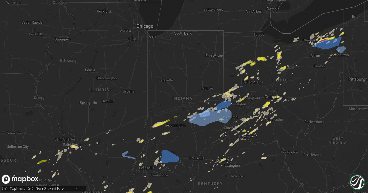
Hail Map in Indiana on May 21, 2022
Get this storm
May 21 map
$229
one time, instant access
Download today. No call, no setup
Keep the $229
Bought the map and want the full workflow? Apply the entire $229 to a subscription within 7 days. None of it is wasted.
Every map, not just this one
This buys you this map. Subscription and you get every map we run, in the markets you choose from a few cities to whole states to nationwide. Plus real-time alerts the moment a storm fires.
Contact data
Name, contact info, occupancy, even credit band for addresses in the footprint. You go from where it hit to who to call.
Become the source they trust
Unlimited branding weather history reports on demand. You already have the documented answer ready for the property owner, and you are the one who showed up with it.
Property data and RoofTrace estimates
Pull up any address you have got, its value and the exact code rules for that jurisdiction, straight from One Click Code. Then RoofTrace estimates the squares, pitch, and roof value, priced the way you price.
Storm reports in Indiana
Indiana
| Date | Description |
|---|---|
| 05/21/20224:00 PM CDT | Several trees downed near us route 52 and state route 46. Time estimated from radar. |
| 05/21/20223:58 PM CDT | Wastewater plant had building demolished and several trees down. Time estimated from radar. |
| 05/21/20223:57 PM CDT | Trees uprooted in st. Leon area. |
| 05/21/20223:51 PM CDT | A scoreboard was blown down and a trailer was flipped over at east central high school. Time estimated from radar. |
| 05/21/20223:45 PM CDT | Report of trees down near lancaster. Picture received via social media. Time estimated from radar. |
| 05/21/20223:42 PM CDT | Large tree downed along interstate 74 near mile marker 155. Time estimated from radar. |
| 05/21/20223:39 PM CDT | Telephone poles down on south liberty pike. Time estimated from radar. |
| 05/21/20223:30 PM CDT | Trees down |
| 05/21/20223:26 PM CDT | Several power poles downed along us route 421 between w county road 1050 n and the decatur county line. Time estimated from radar. |
| 05/21/20223:25 PM CDT | Large trees down. Estimated wind gust of 75+ mph. |
| 05/21/20223:21 PM CDT | A tree fell on power lines and blocked williar avenue. |
| 05/21/20223:16 PM CDT | Trees down throughout the county. |
| 05/21/20223:15 PM CDT | Spotter estimates 65 mph winds. |
| 05/21/20223:13 PM CDT | Numerous tree limbs down... Some large... Across area. |
| 05/21/20223:11 PM CDT | Winds at monroe lake 58 mph gust... Also heavy rain with tree damage. |
| 05/21/20223:10 PM CDT | Wide spread tree damage reported; front of a roof peeled off on old st rte 421; large trees blocking roads innumerous area. Time estimated from radar. |
| 05/21/20223:07 PM CDT | Trees are down near milltown. |
| 05/21/20223:05 PM CDT | Widespread multiple trees down. Some on homes. Estimated wind gust of 80+mph. Time is estimated. |
| 05/21/20223:03 PM CDT | Trees and power lines are down in marengo. |
| 05/21/20223:00 PM CDT | Multiple trees down. |
| 05/21/20223:00 PM CDT | Multiple trees down. |
| 05/21/20222:56 PM CDT | Received multiple pictures via social media of large tree limbs down on ne side of columbus. Richland township. |
| 05/21/20222:56 PM CDT | Numerous tree limbs down in the area... Highway sign folded over. Report via twitter. Time estimated from radar. |
| 05/21/20222:56 PM CDT | Picture sent to us via social media of a large tree down blocking a road in edinburgh. |
| 05/21/20222:56 PM CDT | Large tree limb down. Wind estimation near 80 mph. Time estimated from radar. |
| 05/21/20222:56 PM CDT | Received multiple pictures via social media of large tree limbs down on ne side of columbus. |
| 05/21/20222:53 PM CDT | Trees down. Time estimated from radar. |
| 05/21/20222:53 PM CDT | Large tree limbs on house. Report via twitter. Time estimated from radar. |
| 05/21/20222:52 PM CDT | Public estimates 65 mph wind. |
| 05/21/20222:50 PM CDT | Trees and power lines are down in english. |
| 05/21/20222:48 PM CDT | Structural damage to steeple on chapel building and roof shingles off. |
| 05/21/20222:40 PM CDT | Large area of trees down. Time estimated from radar. |
| 05/21/20222:38 PM CDT | 3 foot diameter tree fell on corner of house in alford... Several trees and power lines down just southeast of prides creek park. |
| 05/21/20222:30 PM CDT | Tree fell on house. Time estimated from radar. |
| 05/21/20222:30 PM CDT | Large tree branches down. Public reports high wind. |
| 05/21/20222:29 PM CDT | Report from mping: 3-inch tree limbs broken; power poles broken. |
| 05/21/20222:26 PM CDT | Tree fell on house. Time estimated from radar. |
| 05/21/20222:25 PM CDT | Buildings damaged. Time estimated from radar. |
| 05/21/20222:20 PM CDT | Report from mping: 1-inch tree limbs broken; shingles blown off. |
| 05/21/20222:20 PM CDT | Received a report via social media of trees and powerlines down on fairfax and strain ridge rd south of smithville... In. |
| 05/21/20222:10 PM CDT | Dispatch reports power lines down in holland. Time estimated from radar. |
| 05/21/20222:08 PM CDT | Large trees down report via twitter with video. Trees knocked power lines down. |
| 05/21/20222:06 PM CDT | Spotter reports power lines down at the intersection of state route 56 and county road 600w in northwest dubois county. |
| 05/21/20222:03 PM CDT | Large trees and power line down. Time estimated from radar. |
| 05/21/20222:03 PM CDT | Small tree limbs blown down. |
| 05/21/20221:56 PM CDT | Jasper police reports power poles down on 34th street blocking the roadway. Time estimated from radar. |
| 05/21/20221:45 PM CDT | Grain bin on top of house. Report via twitter. Time estimated from radar. |
| 05/21/20221:30 PM CDT | Late report. Multiple trees down blocking roadways. |
| 05/21/20227:47 AM CDT | At 1246 PM CDT, severe thunderstorms were located along a line extending from near Chauncey to near Sumner to 6 miles northwest of Lancaster, moving northeast at 40 mph. HAZARD...60 mph wind gusts and quarter size hail. SOURCE...Radar indicated. IMPACT...Hail damage to vehicles is expected. Expect wind damage to roofs, siding, and trees. Severe thunderstorms will be near... Chauncey around 1250 PM CDT. Lawrenceville around 105 PM CDT.Other locations in the path of these severe thunderstorms includeFlat Rock, Birds, St. Francisville, Russellville and Vincennes. |
| 05/21/20227:30 AM CDT | Lightning strike hit house and caused fire. |
| 05/21/20227:26 AM CDT | At 1226 PM CDT, a severe thunderstorm was located over Fairfield, moving northeast at 50 mph. HAZARD...70 mph wind gusts and quarter size hail. SOURCE...Radar indicated. IMPACT...Hail damage to vehicles is expected. Expect considerable tree damage. Wind damage is also likely to mobile homes, roofs, and outbuildings. This severe thunderstorm will be near... Albion around 1245 PM CDT.Other locations in the path of this severe thunderstorm include WestSalem and Lancaster.This includes Interstate 64 in Illinois between Mile Markers 108 and112. |
| 05/21/202212:03 AM CDT | At 503 PM EDT, a severe thunderstorm was located near Dillsboro, moving east at 40 mph. HAZARD...60 mph wind gusts and quarter size hail. SOURCE...Radar indicated. IMPACT...Minor hail damage to vehicles is possible. Expect wind damage to trees and power lines. Locations impacted include... Cincinnati, Florence, Lawrenceburg, Greendale, Aurora, Walton, Rising Sun, Hidden Valley, Oakbrook, Burlington, Union, Cleves, Dillsboro, Shawnee, Miami Heights, Mack, Wilmington, Pleasant, Grandview and French.This includes the following Interstates... I-71 in Kentucky between mile markers 73 and 77. I-75 in Kentucky between mile markers 171 and 182. |
| 05/20/202211:42 PM CDT | At 442 PM EDT, a severe thunderstorm was located near Eaton, moving northeast at 25 mph. HAZARD...60 mph wind gusts and quarter size hail. SOURCE...Radar indicated. IMPACT...Minor hail damage to vehicles is possible. Expect wind damage to trees and power lines. Locations impacted include... Dayton, Kettering, Huber Heights, Trotwood, Vandalia, Englewood, Tipp City, Eaton, Moraine, West Milton, Oakwood, Wright-Patterson Afb, West Carrollton, Camden, Lewisburg, West Alexandria, Gratis, Riverside, Clayton and Union.This includes the following Interstates... I-70 in Ohio between mile markers 4 and 39. I-75 in Ohio between mile markers 47 and 72. |
| 05/20/202211:39 PM CDT | At 439 PM EDT, a severe thunderstorm was located over Lake Santee, moving east at 45 mph. HAZARD...60 mph wind gusts and quarter size hail. SOURCE...Radar indicated. IMPACT...Minor hail damage to vehicles is possible. Expect wind damage to trees and power lines. Locations impacted include... Hamilton, Fairfield, Oxford, Batesville, Brookville, Ross, West College Corner, Oldenburg, Darrtown, Lake Santee, Salem, Reily, Blooming Grove, Metamora, Millville, St. Leon, Laurel, Scipio, College Corner and Cedar Grove.This includes I-74 in Indiana between mile markers 145 and 162. |
| 05/20/202211:24 PM CDT | At 423 PM EDT, severe thunderstorms were located along a line extending from 9 miles west of Scottsburg to near Corydon, moving east at 40 mph. HAZARD...60 mph wind gusts. SOURCE...Radar indicated. IMPACT...Expect damage to roofs, siding, and trees. Severe thunderstorms will be near... Scottsburg around 435 PM EDT.Other locations in the path of these severe thunderstorms include St.Dennis, Pleasure Ridge Park, Valley Station, Shively, Fairdale,Louisville, Audubon Park, Watterson Park, Lynnview, Parkway Village,Poplar Hills, Newburg, Okolona, West Buechel, Hollow Creek, SenecaGardens, Strathmoor Village, Rolling Fields, Riverwood, NorbourneEstates, Kingsley, Strathmoor Manor, Bellewood, St. Matthews,Madison, Hurstbourne, Graymoor-Devondale, Windy Hills, HurstbourneAcres, St. Regis Park, Beechwood Village, Barbourmeade, Northfield,Jeffersontown, Lyndon, Middletown, Douglass Hills, Anchorage,Worthington Hills, Coldstream, Rolling Hills, Langdon Place andPlantation. |
| 05/20/202211:17 PM CDT | At 416 PM EDT, a severe thunderstorm was located 8 miles northwest of Greensburg, or 11 miles southeast of Shelbyville, moving east at 50 mph. HAZARD...60 mph wind gusts. SOURCE...Radar indicated. IMPACT...Expect damage to roofs, siding, and trees. This severe thunderstorm will be near... Sandusky around 420 PM EDT. Milroy around 425 PM EDT. Clarksburg and Lake Santee around 430 PM EDT. New Salem around 435 PM EDT.Other locations in the path of this severe thunderstorm includeGlenwood.This includes Interstate 74 between mile markers 126 and 144. |
| 05/20/202210:58 PM CDT | At 357 PM EDT, severe thunderstorms were located along a line extending from Greenwood to 8 miles southeast of Franklin, moving northeast at 50 mph. HAZARD...60 mph wind gusts and quarter size hail. SOURCE...Radar indicated. IMPACT...Hail damage to vehicles is expected. Expect wind damage to roofs, siding, and trees. Severe thunderstorms will be near... Marietta and Boggstown around 405 PM EDT. Fairland around 410 PM EDT. Shelbyville and New Palestine around 415 PM EDT.Other locations in the path of these severe thunderstorms includeWaldron, Greenfield, Morristown, Manilla, Moscow, Carthage andArlington.This includes the following highways... Interstate 65 between mile markers 80 and 102. Interstate 74 between mile markers 99 and 122. |
| 05/20/202210:55 PM CDT | At 355 PM EDT, a severe thunderstorm was located near New Madison, moving northeast at 35 mph. HAZARD...60 mph wind gusts and quarter size hail. SOURCE...Radar indicated. IMPACT...Minor hail damage to vehicles is possible. Expect wind damage to trees and power lines. Locations impacted include... Greenville, Versailles, Covington, Bradford, Ansonia, New Madison, Webster, Wayne Lakes, Russia, Gettysburg, Osgood, North Star, Hollansburg, Rossburg, Palestine, Yorkshire, Union Corners, Polo, Darke County Airport and State Route 47 at US Route 127. |
| 05/20/202210:53 PM CDT | At 353 PM EDT, a severe thunderstorm was located near Columbus, moving northeast at 50 mph. HAZARD...60 mph wind gusts. SOURCE...Radar indicated. IMPACT...Expect damage to roofs, siding, and trees. This severe thunderstorm will be near... Hope, Flat Rock and Newbern around 400 PM EDT. Hartsville around 405 PM EDT. Milford, Geneva and Burney around 410 PM EDT.Other locations in the path of this severe thunderstorm includeAdams, St. Paul, Waldron and Greensburg.This includes the following highways... Interstate 65 between mile markers 58 and 82. Interstate 74 between mile markers 122 and 133. |
| 05/20/202210:28 PM CDT | At 328 PM EDT, a severe thunderstorm was located over Martinsville, or 19 miles north of Bloomington, moving northeast at 40 mph. HAZARD...60 mph wind gusts and quarter size hail. SOURCE...Radar indicated. IMPACT...Hail damage to vehicles is expected. Expect wind damage to roofs, siding, and trees. This severe thunderstorm will be near... Bethany around 335 PM EDT. Brooklyn and Morgantown around 340 PM EDT. Waverly around 345 PM EDT.Other locations in the path of this severe thunderstorm includeBargersville, Greenwood, Franklin, New Whiteland and Whiteland.This includes Interstate 65 between mile markers 89 and 100. |
| 05/20/202210:03 PM CDT | At 303 PM EDT, a severe thunderstorm was located 8 miles southeast of Bloomfield, or 18 miles northwest of Bedford, moving northeast at 40 mph. HAZARD...60 mph wind gusts and quarter size hail. SOURCE...Radar indicated. IMPACT...Hail damage to vehicles is expected. Expect wind damage to roofs, siding, and trees. This severe thunderstorm will be near... Solsberry around 315 PM EDT.Other locations in the path of this severe thunderstorm includeHarrodsburg, Bloomington, Smithville, Monroe Reservoir, IndianaUniversity, Fairfax State Recreation Area and Whitehall. |
| 05/20/20229:58 PM CDT | At 258 PM EDT, a severe thunderstorm was located over Spencer, or 16 miles northwest of Bloomington, moving northeast at 40 mph. HAZARD...60 mph wind gusts and quarter size hail. SOURCE...Radar indicated. IMPACT...Hail damage to vehicles is expected. Expect wind damage to roofs, siding, and trees. This severe thunderstorm will be near... Stinesville around 305 PM EDT. Gosport and Quincy around 310 PM EDT. Paragon around 315 PM EDT.Other locations in the path of this severe thunderstorm includeMartinsville, Centerton, Mahalasville and Lake Hart. |
| 05/20/20229:55 PM CDT | At 255 PM EDT/155 PM CDT/, severe thunderstorms were located along a line extending from 10 miles southeast of Washington to 6 miles north of Eureka, moving east at 30 mph. HAZARD...60 mph wind gusts and quarter size hail. SOURCE...Radar indicated. IMPACT...Hail damage to vehicles is expected. Expect wind damage to roofs, siding, and trees. Severe thunderstorms will be near... Jasper around 310 PM EDT. |
| 05/20/20229:25 PM CDT | At 225 PM EDT, a severe thunderstorm was located 10 miles north of Linton, or 21 miles southeast of Terre Haute, moving northeast at 40 mph. HAZARD...60 mph wind gusts and quarter size hail. SOURCE...Radar indicated. IMPACT...Hail damage to vehicles is expected. Expect wind damage to roofs, siding, and trees. This severe thunderstorm will be near... Clay City around 235 PM EDT. Coal City around 240 PM EDT.Other locations in the path of this severe thunderstorm includePatricksburg, Bowling Green, Freedom, Spencer and McCormicks CreekState Park. |
| 05/20/20229:08 PM CDT | At 206 PM CDT, a severe thunderstorm was located near Folsomville, or 11 miles east of Boonville, moving east at 30 mph. HAZARD...60 mph wind gusts and quarter size hail. SOURCE...Radar indicated. At 203 PM, a 60 mph wind gust was reported in Gentryville. IMPACT...Hail damage to vehicles is expected. Expect wind damage to roofs, siding, and trees. This severe thunderstorm will be near... Dale around 215 PM CDT. Santa Claus around 220 PM CDT.This includes Interstate 64 in Indiana between Mile Markers 57 and60. |
All States Impacted by Hail Map on May 21, 2022
Cities Impacted by Hail Map on May 21, 2022
- Tunica, MS
- Lake Cormorant, MS
- Robinsonville, MS
- Hernando, MS
- Saint Albans, VT
- Sheldon, VT
- Swanton, VT
- Morrisville, VT
- Hyde Park, VT
- Wapakoneta, OH
- Bedford, OH
- Gates Mills, OH
- Rome, OH
- Chesterland, OH
- Orwell, OH
- Windsor, OH
- Chagrin Falls, OH
- Novelty, OH
- Macedonia, OH
- Newbury, OH
- Cleveland, OH
- Beachwood, OH
- Burton, OH
- Solon, OH
- Montville, OH
- Mentor, OH
- Willoughby, OH
- Chardon, OH
- Thompson, OH
- Huntsburg, OH
- Middlefield, OH
- Painesville, OH
- Warsaw, OH
- Columbus, OH
- Reynoldsburg, OH
- Laquey, MO
- Richland, MO
- Foster, KY
- Falmouth, KY
- Butler, KY
- Sycamore, OH
- Findlay, OH
- Carey, OH
- Upper Sandusky, OH
- Vanlue, OH
- McCutchenville, OH
- Mount Blanchard, OH
- Alvada, OH
- Arlington, OH
- New Riegel, OH
- Rock Creek, OH
- Independence, OH
- Maple Heights, OH
- Grove City, OH
- Orient, OH
- Bloomingburg, OH
- Washington Court House, OH
- Mount Sterling, OH
- London, OH
- Mount Perry, OH
- Rosebud, MO
- Gerald, MO
- Millersport, OH
- Baltimore, OH
- Central Square, NY
- Pennellville, NY
- West Monroe, NY
- Brewerton, NY
- Constantia, NY
- Saint Clair, MI
- East China, MI
- Clarks Mills, PA
- Fredonia, PA
- Greenville, PA
- Stoneboro, PA
- Conneautville, PA
- Alliance, OH
- Louisville, OH
- Ashtabula, OH
- Geneva, OH
- Austinburg, OH
- Jefferson, OH
- Parish, NY
- Clyde, OH
- Bellevue, OH
- Fresno, OH
- Errol, NH
- Canaan, VT
- Colebrook, NH
- Guildhall, VT
- Chillicothe, OH
- Circleville, OH
- Kingston, OH
- Lynn, IN
- Williamsburg, IN
- Republic, OH
- Derby Line, VT
- New Castle, IN
- Pleasantville, OH
- Russellville, OH
- Paris, KY
- Cynthiana, KY
- North Jackson, OH
- Youngstown, OH
- Lorain, OH
- Lewis, NY
- Williston, VT
- Keeseville, NY
- South Burlington, VT
- Willsboro, NY
- Shelburne, VT
- New Knoxville, OH
- Saint Marys, OH
- Forestport, NY
- Jeromesville, OH
- Mount Victory, OH
- Ridgeway, OH
- Kenton, OH
- Orleans, VT
- Almont, MI
- Flat Rock, IN
- Edinburgh, IN
- Shelbyville, IN
- Columbus, IN
- Eastlake, OH
- Derby, VT
- New Carlisle, OH
- Saint Paris, OH
- Clayton, OH
- Brookville, OH
- Dayton, OH
- North Hampton, OH
- Springfield, OH
- Englewood, OH
- Vandalia, OH
- Tipp City, OH
- Ellicottville, NY
- Franklinville, NY
- Great Valley, NY
- Pierpont, OH
- Conneaut, OH
- Kingsville, OH
- North Bloomfield, OH
- Louisville, IL
- Lake Milton, OH
- Berlin Center, OH
- Diamond, OH
- Fulton, NY
- Phoenix, NY
- Rouses Point, NY
- Centerville, IN
- Milton, IN
- Island Pond, VT
- Pittsburg, NH
- Norton, VT
- West Charleston, VT
- Averill, VT
- Andover, ME
- East Charleston, VT
- Morgan, VT
- Cuba, MO
- Atlantic, PA
- Cochranton, PA
- Meadville, PA
- Conneaut Lake, PA
- Potosi, MO
- Sullivan, MO
- House Springs, MO
- Arnold, MO
- Imperial, MO
- Fenton, MO
- High Ridge, MO
- Franklin, IN
- Trafalgar, IN
- Nineveh, IN
- Essex, NY
- West Alexandria, OH
- Sodus, NY
- Williamson, NY
- Mount Gilead, OH
- Galion, OH
- Edison, OH
- Baltic, OH
- Hillsboro, OH
- Waterford, PA
- Cambridge Springs, PA
- Germanton, NC
- Walnut Cove, NC
- Williamstown, KY
- New Wilmington, PA
- Pulaski, PA
- West Middlesex, PA
- Wirtz, VA
- Hardy, VA
- Stamping Ground, KY
- Conesville, OH
- Coshocton, OH
- Bourbon, MO
- Fincastle, VA
- Troutville, VA
- Boones Mill, VA
- Rocky Mount, VA
- O'Fallon, IL
- Belleville, IL
- Canal Winchester, OH
- Pataskala, OH
- Pickerington, OH
- Groveport, OH
- Lockbourne, OH
- Sabina, OH
- Troutdale, VA
- Sugar Grove, VA
- Burlington, KY
- Murfreesboro, NC
- Pendleton, NC
- Saint James, MO
- Saint Elmo, IL
- Troy, TN
- Hornbeak, TN
- Ridgely, TN
- Union City, TN
- Tiptonville, TN
- Obion, TN
- Williamsburg, OH
- Bethel, OH
- Frankfort, KY
- Roxboro, NC
- Timberlake, NC
- Batavia, OH
- Bahama, NC
- Imboden, AR
- Pocahontas, AR
- Greensburg, IN
- Milroy, IN
- Dover, TN
- Waverly, TN
- Hazel, KY
- Springville, TN
- Tennessee Ridge, TN
- Camden, TN
- Stewart, TN
- Mansfield, TN
- Cumberland City, TN
- Erin, TN
- Henry, TN
- Paris, TN
- Hollow Rock, TN
- New Concord, KY
- Big Sandy, TN
- Bruceton, TN
- Buchanan, TN
- Puryear, TN
- Whiteville, TN
- Iuka, IL
- Oil Trough, AR
- Pleasant Plains, AR
- Vienna, IL
- Cypress, IL
- Jonesboro, AR
- Princeton, NC
- Kenly, NC
- Selma, NC
- Canton, NC
- Waynesville, NC
- Heber Springs, AR
- McNeil, AR
- Waldo, AR
- Carlisle, AR
- Humnoke, AR
- Stuttgart, AR
- Batesville, AR
- Floral, AR
- Pulaski, TN
- Memphis, TN
- Swifton, AR
- Marshall, NC
- Louin, MS
- Cosby, TN
- Grandview, TX
- Piney Flats, TN
- Blountville, TN
- Johnson City, TN
- Kinston, AL
- Millen, GA
- Garfield, GA
- Midville, GA
- Marion, KY
- Salem, KY
- Fredonia, KY
- Burna, KY
- Eddyville, KY
- Princeton, KY
- Violet Hill, AR
- Salem, AR
- Hardy, AR
- Cherokee Village, AR
- Melbourne, AR
- Oxford, AR
- Franklin, AR
- Wiseman, AR
- Ash Flat, AR
- Glencoe, AR
- Horseshoe Bend, AR
- Brockwell, AR
- Lorena, TX
- Eva, TN
- McKenzie, TN
- Williamsville, MO
- Lewisburg, TN
- Clinton, KY
- Prospect, TN
- Lexington, NC
- Unionville, TN
- Wilburn, AR
- Saint Joe, AR
- Marshall, AR
- Oxford, NC
- Leicester, NC
- Fort Campbell, KY
- Oak Grove, KY
- Searcy, AR
- Poplar Bluff, MO
- Grandin, MO
- Ellsinore, MO
- Chuckey, TN
- Limestone, TN
- Buena Vista, TN
- Osceola, AR
- Mountain View, AR
- Pleasant Grove, AR
- Vilas, NC
- Sulphur Rock, AR
- Cord, AR
- Norman, AR
- Turbeville, SC
- Olanta, SC
- Horatio, AR
- Winthrop, AR
- Pine Bluff, AR
- McBee, SC
- Hattiesburg, MS
- Petal, MS
- Eagletown, OK
- Mena, AR
- Cabot, AR
- Cope, SC
- Anderson, AL
- Athens, AL
- Rogersville, AL
- Lester, AL
- Elkmont, AL
- Fort Mill, SC
- Kilgore, TX
- Overton, TX
- Humphrey, AR
- Aiken, SC
- Waxahachie, TX
- Hampton, AR
- Ovett, MS
- Ellisville, MS
- Hartsville, SC
- Rocky Ford, GA
- Nashville, AR
- Letohatchee, AL
- Fort Deposit, AL
- Hayneville, AL
- Springhill, LA
- West Mansfield, OH
- Mansfield, OH
- Davisburg, MI
- Shelbyville, KY
- East Carondelet, IL
- Dupo, IL
- East Saint Louis, IL
- Millstadt, IL
- Fairview Heights, IL
- Saint Louis, MO
- Petersburg, IN
- Winslow, IN
- Morehead, KY
- Carlisle, KY
- Charles City, VA
- Riner, VA
- Willis, VA
- Check, VA
- Indian Valley, VA
- Pilot, VA
- Floyd, VA
- Radford, VA
- Deerfield, OH
- Petersburg, WV
- Moorefield, WV
- Bruceville, IN
- Bicknell, IN
- Galena, MO
- Laurel Fork, VA
- Hillsville, VA
- Dickson, TN
- Burns, TN
- Danbury, NC
- Westfield, NC
- Bethel, NC
- Selmer, TN
- Ramer, TN
- Fremont, NC
- Stantonsburg, NC
- Wilson, NC
- Elkin, NC
- Roaring River, NC
- Ronda, NC
- Thurmond, NC
- State Road, NC
- North Wilkesboro, NC
- Lawrenceburg, TN
- Loretto, TN
- Leoma, TN
- Chester, SC
- Grand Junction, TN
- Michigan City, MS
- Moscow, TN
- Cordova, SC
- Texarkana, AR
- Proctor, AR
- Edmondson, AR
- Hughes, AR
- Aviston, IL
- Hot Springs Village, AR
- Lonsdale, AR
- Benton, AR
- Owensville, IN
- Princeton, IN
- Chrisney, IN
- Gentryville, IN
- Hot Springs National Park, AR
- North Tazewell, VA
- Umpire, AR
- Langley, AR
- Newhope, AR
- Jeffersonville, OH
- Wilmington, OH
- Jamestown, OH
- New Richmond, OH
- Cincinnati, OH
- Amelia, OH
- Cameron, SC
- Orangeburg, SC
- Elloree, SC
- Patriot, IN
- Rising Sun, IN
- Union, KY
- Oxford, OH
- College Corner, OH
- Somerville, OH
- Camden, OH
- Minter, AL
- Orrville, AL
- Carson, VA
- Dewitt, VA
- Dinwiddie, VA
- Saint Francisville, IL
- Lawrenceville, IL
- Sumner, IL
- Bridgeport, IL
- Claremont, IL
- Lansing, NC
- Creston, NC
- Greenfield, OH
- Leesburg, OH
- Marion, VA
- Suffolk, VA
- Sparta, KY
- Warsaw, KY
- Glencoe, KY
- Carlyle, IL
- Lawrenceburg, KY
- Locust Grove, AR
- Rosie, AR
- Sardinia, OH
- Lynchburg, OH
- Mount Orab, OH
- Elk Horn, KY
- Cecilia, KY
- Glendale, KY
- Linesville, PA
- Andover, OH
- Dorset, OH
- Drummonds, TN
- North Little Rock, AR
- Little Rock, AR
- Sunbury, OH
- Centerburg, OH
- Liberty, KY
- Success, AR
- Felicity, OH
- Ozan, AR
- Mineral Springs, AR
- Lockesburg, AR
- Columbus, AR
- Dittmer, MO
- Catawissa, MO
- Hillsboro, MO
- Pacific, MO
- Robertsville, MO
- Richwoods, MO
- Eureka, MO
- Cedar Hill, MO
- Guion, AR
- Mount Pleasant, AR
- Fulton, AR
- Ashdown, AR
- Meridian, MS
- Ore City, TX
- Blytheville, AR
- Safford, AL
- Dyer, TN
- Trenton, TN
- Martin, TN
- Ravenden Springs, AR
- Warm Springs, AR
- Goldsboro, NC
- Crawfordsville, AR
- Marion, AR
- Wakefield, VA
- Carrsville, VA
- Franklin, VA
- Zuni, VA
- Sedley, VA
- Courtland, VA
- Ivor, VA
- Hagarville, AR
- Dover, AR
- Compton, AR
- Lamar, AR
- Clarksville, AR
- Somerville, TN
- New London, NC
- Mount Pleasant, NC
- Albemarle, NC
- Dierks, AR
- Augusta, AR
- Bald Knob, AR
- Summerton, SC
- Rosston, AR
- Conway, AR
- Bigelow, AR
- Hot Springs, NC
- Stephens, AR
- Magnolia, AR
- Marked Tree, AR
- Lepanto, AR
- Jackman, ME
- Robards, KY
- Newark, AR
- Corydon, KY
- Henderson, KY
- Perryville, AR
- Roland, AR
- Paron, AR
- Jessieville, AR
- Elizabethtown, KY
- Manilla, IN
- Columbia, SC
- Tuscola, IL
- Seaman, OH
- Winchester, OH
- Georgetown, OH
- Iron City, TN
- Florence, AL
- Madisonville, KY
- Nortonville, KY
- White Plains, KY
- Graham, KY
- Earlington, KY
- Mortons Gap, KY
- Hatfield, AR
- Toomsuba, MS
- Frankfort, OH
- Nebo, KY
- Manitou, KY
- Livingston, AL
- Emelle, AL
- Princeton, WV
- South Salem, OH
- Dale, IN
- Lincoln City, IN
- Stendal, IN
- Boonville, IN
- Tennyson, IN
- Wickliffe, OH
- Rougemont, NC
- Aulander, NC
- Morgantown, IN
- Nashville, IN
- Whitetop, VA
- Mouth Of Wilson, VA
- Makanda, IL
- Cobden, IL
- Goreville, IL
- Carbondale, IL
- Hampshire, TN
- Scott City, MO
- Benton, MO
- Oran, MO
- Thebes, IL
- Chaffee, MO
- Culleoka, TN
- Thompsons Station, TN
- College Grove, TN
- Franklin, TN
- China Grove, NC
- Landis, NC
- Kannapolis, NC
- Centerville, TN
- Evansville, IN
- Blair, SC
- Hooks, TX
- Doniphan, MO
- Brecksville, OH
- Northfield, OH
- Johnson, VT
- Afton, TN
- Greeneville, TN
- Scott, AR
- Huntsville, OH
- Rushsylvania, OH
- Belle Center, OH
- Bellefontaine, OH
- Arcanum, OH
- West Milton, OH
- Laura, OH
- Ludlow Falls, OH
- Corinth, MS
- Huntsville, AR
- Berryville, AR
- Kosse, TX
- Marlin, TX
- Benton, LA
- Belcher, LA
- Como, NC
- Witter, AR
- State Line, MS
- Crestline, OH
- Tiro, OH
- Bentonia, MS
- Canton, MS
- Vaughan, MS
- Flag Pond, TN
- Fouke, AR
- West Memphis, AR
- New Haven, MI
- Macomb, MI
- New Baltimore, MI
- Jackson, TN
- Kirby, AR
- North Troy, VT
- Newport Center, VT
- Newport, VT
- Cherokee, AL
- Barton, VT
- Caseyville, IL
- Midlothian, TX
- Thornton, TX
- Hanson, KY
- Sebree, KY
- Slaughters, KY
- Hamilton, TX
- Jonesboro, TX
- Clifton, TX
- Cranfills Gap, TX
- Hico, TX
- Patton, MO
- Russia, OH
- Eaton, OH
- West Manchester, OH
- Covington, OH
- Fort Loramie, OH
- New Paris, OH
- Greenville, OH
- Pitsburg, OH
- Lewisburg, OH
- Eldorado, OH
- Richmond, IN
- Fountain City, IN
- New Madison, OH
- Palestine, OH
- Versailles, OH
- Hollansburg, OH
- Sidney, OH
- Piqua, OH
- Gettysburg, OH
- Bradford, OH
- Houston, OH
- Douglassville, TX
- Advance, MO
- Solsberry, IN
- Spencer, IN
- Tiffin, OH
- Bloomville, OH
- Saint Regis Falls, NY
- Potsdam, NY
- Bardstown, KY
- Bloomfield, KY
- Mineral Point, MO
- Valley Head, WV
- Durham, NC
- Hillsborough, NC
- Smithfield, VA
- Georgetown, KY
- Green Forest, AR
- Rushville, IN
- Finchville, KY
- Fisherville, KY
- Henrico, NC
- Valentines, VA
- Lenoir, NC
- Dongola, IL
- Buncombe, IL
- Marengo, OH
- Fulton, OH
- Ashley, OH
- Cardington, OH
- Summertown, TN
- Ethridge, TN
- Cottage Grove, TN
- Corning, AR
- Mountain Pine, AR
- King, NC
- Newberry, SC
- Scottsboro, AL
- Dyersburg, TN
- Newbern, TN
- Brickeys, AR
- Amity, AR
- Glenwood, AR
- Claudville, VA
- Mount Airy, NC
- Ararat, VA
- Pomaria, SC
- Cayce, SC
- Gaston, SC
- Hopkins, SC
- West Columbia, SC
- Maynard, AR
- Walls, MS
- Mullin, TX
- Eddy, TX
- Clayton Lake, ME
- Enosburg Falls, VT
- Berlin, NH
- Lobelville, TN
- Oakboro, NC
- Jasper, AR
- Spring Lake, NC
- Dyess, AR
- Tyronza, AR
- Goodspring, TN
- Waldron, IN
- Saint Joseph, TN
- Killen, AL
- Five Points, TN
- Muscle Shoals, AL
- Minor Hill, TN
- Lexington, AL
- Watson, OK
- Laurinburg, NC
- Gibson, NC
- McColl, SC
- Clio, SC
- Maxton, NC
- Little Rock, SC
- Horse Cave, KY
- Cave City, KY
- Tallassee, AL
- Decatur, MS
- Hickory, MS
- Enterprise, MS
- Rose Hill, MS
- Newton, MS
- Quitman, MS
- Stonewall, MS
- Pachuta, MS
- Modoc, IN
- Hagerstown, IN
- Economy, IN
- Spiceland, IN
- Knightstown, IN
- Rockport, IN
- Shady Valley, TN
- Rural Retreat, VA
- Windsor, VA
- Trimble, TN
- Kenton, TN
- Duck River, TN
- Hohenwald, TN
- Linden, TN
- Tarboro, NC
- Greenville, NC
- Salisbury, NC
- Adamsville, TN
- Crump, TN
- Ratcliff, AR
- Cardwell, MO
- Arbyrd, MO
- Columbia, TN
- Algonac, MI
- Fair Haven, MI
- Marine City, MI
- Harsens Island, MI
- London, AR
- Russellville, AR
- Delaware, AR
- Carroll, OH
- Rock Hill, SC
- Caddo Gap, AR
- Carlisle, SC
- Homer, IN
- Arlington, IN
- Morristown, IN
- Winnsboro, SC
- Richland Springs, TX
- San Saba, TX
- Marshall, TX
- Harleton, TX
- Jefferson, TX
- Highgate Center, VT
- Alburgh, VT
- Franklin, VT
- Clarksburg, OH
- New Holland, OH
- Williamsport, OH
- Newport, PA
- Millerstown, PA
- Ickesburg, PA
- Elliottsburg, PA
- Cook Sta, MO
- Steelville, MO
- Jonesborough, TN
- Telford, TN
- Lilbourn, MO
- Parma, MO
- Huntingdon, TN
- Greenbrier, AR
- Morrilton, AR
- Plumerville, AR
- Springfield, AR
- Solgohachia, AR
- Damascus, AR
- Troy, OH
- Holland, IN
- Huntingburg, IN
- Lawrenceville, VA
- Edgemont, AR
- Tumbling Shoals, AR
- Fairfield Bay, AR
- Prim, AR
- Drasco, AR
- Higden, AR
- Ida, AR
- Shirley, AR
- Concord, AR
- Greenfield, TN
- Gleason, TN
- Dresden, TN
- Mount Pleasant, TN
- Olive Hill, KY
- Maumelle, AR
- Little Rock Air Force Base, AR
- El Paso, AR
- Vilonia, AR
- Mayflower, AR
- Jacksonville, AR
- Sherwood, AR
- Spring Hill, TN
- Lewisville, IN
- Falmouth, IN
- Shelbyville, TN
- Poseyville, IN
- New Harmony, IN
- Wadesville, IN
- Mount Vernon, IN
- Cullowhee, NC
- Smithfield, NC
- Clayton, NC
- Taylorsville, KY
- Parsons, TN
- Decaturville, TN
- Munford, TN
- Millington, TN
- Saltillo, MS
- Baldwyn, MS
- New Albany, MS
- Blue Springs, MS
- Guntown, MS
- Tionesta, PA
- Marienville, PA
- Walton, KY
- Darlington, SC
- Midway, KY
- Murfreesboro, AR
- Newberry, IN
- Springville, IN
- Bloomfield, IN
- Owensburg, IN
- Scotland, IN
- Bishopville, SC
- Coldwater, MS
- Columbia, IL
- Valmeyer, IL
- De Queen, AR
- Kershaw, SC
- Texarkana, TX
- Queen City, TX
- Brownstown, IL
- Moro, AR
- Junction City, AR
- El Dorado, AR
- Connersville, IN
- Glenwood, IN
- Brownsville, IN
- Damascus, VA
- Chilhowie, VA
- Laurel Bloomery, TN
- Atlanta, TX
- Bloomburg, TX
- Bivins, TX
- Doddridge, AR
- Linden, TX
- Brownsboro, AL
- Huntsville, AL
- Owens Cross Roads, AL
- Dolphin, VA
- Rogersville, MO
- Fordland, MO
- Selma, AL
- Tyler, AL
- Freeman, VA
- Warfield, VA
- Spruce Pine, NC
- Marion, NC
- Elkton, KY
- Shell Knob, MO
- Blue Eye, MO
- Lampe, MO
- Deer, AR
- Polkton, NC
- Peachland, NC
- Charlotte, NC
- Sheridan, AR
- Redfield, AR
- Timbo, AR
- Fox, AR
- Windsor, NC
- Leesville, SC
- Batesburg, SC
- Alexander, AR
- Saratoga, AR
- New Edinburg, AR
- Neeses, SC
- Royal, AR
- Bonnerdale, AR
- Marshville, NC
- Hope, AR
- Manning, SC
- Dublin, TX
- Stephenville, TX
- Milan, GA
- Jacksonville, GA
- Rhine, GA
- Chilton, TX
- Peterman, AL
- McKenzie, AL
- Evergreen, AL
- Bainbridge, OH
- Highland, IL
- Saint Jacob, IL
- Marine, IL
- Smithland, KY
- Yorktown, VA
- Surry, VA
- Fort Eustis, VA
- Newport News, VA
- Hayes, VA
- Gloucester Point, VA
- Williamsburg, VA
- Norfork, AR
- Calico Rock, AR
- Flippin, AR
- Mountain Home, AR
- Quitman, AR
- Lynnville, TN
- Etowah, AR
- Newport, AR
- Tuckerman, AR
- Del Rio, TN
- Hartford, TN
- Newport, TN
- Portageville, MO
- Hayti, MO
- Eureka Springs, AR
- Bridgeport, AL
- Richburg, SC
- Great Falls, SC
- Pearcy, AR
- Bismarck, AR
- Whitmire, SC
- Hephzibah, GA
- Eutaw, AL
- Adrian, GA
- Soperton, GA
- Lancaster, NH
- Boonville, NY
- Port Leyden, NY
- Constableville, NY
- Lima, OH
- Bucyrus, OH
- Caledonia, OH
- Harrison Township, MI
- Ashville, OH
- Loveland, OH
- Pleasant Plain, OH
- Maineville, OH
- Ft Mitchell, KY
- Clarksville, OH
- Morrow, OH
- Latonia, KY
- Blanchester, OH
- Newport, KY
- Martinsville, OH
- Midland, OH
- Fort Thomas, KY
- Goshen, OH
- New Vienna, OH
- Milford, OH
- Maplewood, OH
- Jackson Center, OH
- Lakeview, OH
- Lewistown, OH
- Waddy, KY
- Edwardsport, IN
- California, KY
- Alexandria, KY
- Caledonia, MO
- Belleview, MO
- Belgrade, MO
- Roseland, VA
- Lovingston, VA
- Brenton, WV
- Bagdad, KY
- Munfordville, KY
- Hiwassee, VA
- Dugspur, VA
- Mount Eden, KY
- Roanoke, VA
- West Forks, ME
- Vienna, OH
- Niles, OH
- Girard, OH
- Worthington, IN
- Hymera, IN
- Shelburn, IN
- Coalmont, IN
- Coal City, IN
- Jasonville, IN
- Lewis, IN
- Freedom, IN
- Sullivan, IN
- Clay City, IN
- Mountain City, TN
- Smithville, AR
- Strawberry, AR
- Poughkeepsie, AR
- Ravenden, AR
- Black Rock, AR
- Evening Shade, AR
- Williford, AR
- McEwen, TN
- Brookport, IL
- Golconda, IL
- Plymouth, OH
- Willard, OH
- Monroeville, OH
- Attica, OH
- New Washington, OH
- Ontario, NY
- Stuart, VA
- Bethpage, TN
- Gallatin, TN
- Mammoth Spring, AR
- Liberty, IN
- Brookville, IN
- Apex, NC
- Cary, NC
- Morrisville, NC
- Pettigrew, AR
- Kansas, OK
- Delphos, OH
- Pandora, OH
- Forest, OH
- Columbus Grove, OH
- Cairo, OH
- Mount Cory, OH
- Bluffton, OH
- Jenera, OH
- Rawson, OH
- Spencerville, OH
- Ada, OH
- Mason, TN
- La Crosse, VA
- Brodnax, VA
- Williamsport, TN
- Edgemoor, SC
- Delaplaine, AR
- Hoxie, AR
- Peach Orchard, AR
- Marmaduke, AR
- Alicia, AR
- Knobel, AR
- Paragould, AR
- Bono, AR
- Walnut Ridge, AR
- Beech Grove, AR
- Piggott, AR
- Biggers, AR
- Lafe, AR
- Rector, AR
- Cash, AR
- O'Kean, AR
- Yadkinville, NC
- Mocksville, NC
- Stamps, AR
- Taylor, AR
- Fall Branch, TN
- Franklin, TX
- Cooter, MO
- Saint Francis, AR
- Gobler, MO
- Caruthersville, MO
- Holcomb, MO
- Catron, MO
- Senath, MO
- Bragg City, MO
- Wardell, MO
- Finley, TN
- Kennett, MO
- Steele, MO
- Clarkton, MO
- Campbell, MO
- Malden, MO
- Greenway, AR
- Hornersville, MO
- Gideon, MO
- Manila, AR
- Leachville, AR
- Lenox, TN
- Forsyth, GA
- Nashville, IL
- Dresden, OH
- South Boston, VA
- Yanceyville, NC
- Burlington, NC
- Byhalia, MS
- Holly Springs, MS
- Red Banks, MS
- Rutherford, TN
- Prescott, AR
- Mayfield, KY
- Lynchburg, SC
- Hickman, KY
- New Madrid, MO
- Rives, TN
- East Prairie, MO
- Marston, MO
- Seminary, MS
- Jerusalem, AR
- Cleveland, AR
- New Blaine, AR
- Witts Springs, AR
- Scranton, AR
- Atkins, AR
- Clinton, AR
- Dennard, AR
- Choctaw, AR
- Center Ridge, AR
- Pelsor, AR
- Bee Branch, AR
- Hattieville, AR
- Hector, AR
- Leslie, AR
- Tilly, AR
- Scotland, AR
- Ozone, AR
- Stanton, TN
- Beebe, AR
- Northport, AL
- Oakman, AL
- Brookwood, AL
- Quinton, AL
- Bessemer, AL
- Adger, AL
- Norwood, NC
- Waco, TX
- Jackson, AL
- Frenchmans Bayou, AR
- Arlington, TN
- Turrell, AR
- Vandervoort, AR
- Cove, AR
- Wickes, AR
- Elgin, SC
- Fairfax, SC
- Allendale, SC
- Ozark, IL
- West Harrison, IN
- New Trenton, IN
- Cedar Grove, IN
- Madison, IN
- Blackwell, MO
- Fletcher, MO
- Amherst, VA
- Alexandria, OH
- Granville, OH
- Perrysville, OH
- Butler, OH
- Mercer, PA
- Owensville, MO
- Bland, MO
- Belle, MO
- Grundy, VA
- Big Rock, VA
- Bell City, MO
- Chaplin, KY
- Nunda, NY
- Portageville, NY
- Fillmore, NY
- Dalton, NY
- Hunt, NY
- Bismarck, MO
- Irondale, MO
- Lawsonville, NC
- Kevil, KY
- Metropolis, IL
- Melber, KY
- Paducah, KY
- Hickory, KY
- Symsonia, KY
- Arlington, KY
- Bardwell, KY
- West Paducah, KY
- Fancy Farm, KY
- Cunningham, KY
- Wickliffe, KY
- La Center, KY
- Ledbetter, KY
- Barlow, KY
- Boaz, KY
- Trenton, KY
- Mount Judea, AR
- Clyde, NC
- Newburg, MO
- West College Corner, IN
- Meridian, TX
- Iredell, TX
- Waynesfield, OH
- Twin City, GA
- Palestine, TX
- Richmond, MI
- Casco, MI
- Corry, PA
- Corinth, KY
- Owenton, KY
- Jamestown, PA
- Kinsman, OH
- Milan, NH
- Miller City, IL
- Union City, PA
- Glenford, OH
- Somerset, OH
- Thornville, OH
- Matthews, MO
- Hamersville, OH
- Sharon, TN
- Grandview, IN
- Evanston, IN
- Lamar, IN
- Augusta, KY
- Vendor, AR
- Parthenon, AR
- Hasty, AR
- Western Grove, AR
- Reagan, TN
- Enville, TN
- Milledgeville, TN
- Sardis, TN
- Bath Springs, TN
- Scotts Hill, TN
- Saltillo, TN
- Pocahontas, TN
- Wilson, AR
- Joiner, AR
- Houston, AR
- England, AR
- Hensley, AR
- Comanche, TX
- Nesbit, MS
- Thomasville, AL
- Sweet Water, AL
- Doyline, LA
- Sibley, LA
- Valley Mills, TX
- Crawford, TX
- Riesel, TX
- Evant, TX
- Lometa, TX
- Purmela, TX
- Goldthwaite, TX
- Gatesville, TX
- Lampasas, TX
- Star, TX
- Denmark, SC
- Bamberg, SC
- Catherine, AL
- McGregor, TX
- Camden, AL
- Rowesville, SC
- Branchville, SC
- Caldwell, TX
- Gainesville, AL
- Epes, AL
- Dallas, TX
- Marietta, TX
- Mexia, TX
- Wortham, TX
- Mart, TX
- Axtell, TX
- Moody, TX
- Diana, TX
- May, TX
- Mount Calm, TX
- Prairie Hill, TX
- Rodessa, LA
- Ida, LA
- Lohn, TX
- Lott, TX
- Reagan, TX
- Rosebud, TX
- Maypearl, TX
- Tyler, TX
- Whitehouse, TX
- Collins, MS
- Plain Dealing, LA
- Macon, GA
- Dry Branch, GA
- Eatonton, GA
- Forest Home, AL
- McRae Helena, GA
- Woodway, TX
- Musella, GA
- Roberta, GA
- Knoxville, GA
- Leakesville, MS
- New Augusta, MS
- Richton, MS
- Bradley, AR
- Longview, TX
- Alberta, AL
- Vinegar Bend, AL
- Buckner, AR
- Italy, TX
- Mize, MS
- Seagoville, TX
- Mesquite, TX
- Bay Springs, MS
- Brooker, FL
- Gause, TX
- Sterrett, AL
- Vincent, AL
- Chelsea, AL
- Wilsonville, AL
- Columbiana, AL
- Harpersville, AL
- Lauderdale, MS
- Pine Apple, AL
- Moselle, MS
- Hosston, LA
- Spicewood, TX
- Hockley, TX
- Boerne, TX
- West, TX
- Elm Mott, TX
- Cadwell, GA
- Falls City, TX
- Smackover, AR
- Monticello, GA
- Quemado, TX
- Bertram, TX
- Burnet, TX
- Perkinston, MS
- Yulee, FL
- Moore, TX
- Devine, TX
- Charlotte, TX
- Bigfoot, TX
- Pearsall, TX
- Jourdanton, TX
- Pleasanton, TX
- McDade, TX
- Del Rio, TX
- Laughlin Afb, TX
- Brackettville, TX
- Brooksville, FL
- Leakey, TX
- Punta Gorda, FL
- Arcadia, FL
- Sonora, TX
- Lake City, FL
- Wellborn, FL
- McAlpin, FL
- Lumberton, MS
- Luling, TX
- Brady, TX
- Plant City, FL
- Gainesville, FL
- Bay Minette, AL
- Pierson, FL
- Bunnell, FL
- Seville, FL
- Comfort, TX
- Lakeland, FL
- Bartow, FL
- Fort Meade, FL
- Ehrhardt, SC
- Hubbard, TX
- Dawson, TX
- Oviedo, FL
- Hunt, TX
- Kendalia, TX
- Medina, TX
- Leesburg, FL
- Clermont, FL
- Tavares, FL
- Howey In The Hills, FL
- Astatula, FL
- Mount Dora, FL
- La Coste, TX
- San Antonio, TX
- Lytle, TX
- Somerset, TX
- Castroville, TX
- Atascosa, TX
- Hearne, TX
- Calvert, TX
- Cameron, TX
- Junction, TX
- Saint Johns, FL
- Orange City, FL
- De Leon Springs, FL
- Deland, FL
- Mountain Home, TX
- Harper, TX
- Mason, TX
- Flatonia, TX
- Lewisville, AR
- Jacksonville, FL
- Milano, TX
- Dime Box, TX
- Giddings, TX
- Green Cove Springs, FL
- Gloster, MS
- Centreville, MS
- Saint Francisville, LA
- Woodville, MS
- Eustis, FL
- Geneva, FL
- Orlando, FL
- Marble Falls, TX
- Austin, TX
- Leander, TX
- Sorrento, FL
- Saint Augustine, FL
- La Pryor, TX
- Alva, FL
- Johnson City, TX
- Blanco, TX
- Dripping Springs, TX
- Wimberley, TX
- Crystal City, TX
- Camp Wood, TX
- Bandera, TX
- Utopia, TX
- Hondo, TX
- Batesville, TX
- D Hanis, TX
- Yancey, TX
- Barksdale, TX
- Rocksprings, TX
- Manor, TX
- Kountze, TX
- Myakka City, FL
- Lodge, SC
- Harwood, TX
- Lake Butler, FL
- Jasper, FL
- Ingram, TX
- New Braunfels, TX
- McQueeney, TX
- Kingsbury, TX
- Seguin, TX
- Richland, TX
- Corsicana, TX
- Rockdale, TX
- Lincoln, TX
- Baker, LA
- Baton Rouge, LA
- Spring Branch, TX
- Tuskegee, AL
- Hardaway, AL
- Jayess, MS
- Tylertown, MS
- Live Oak, FL
- White Springs, FL
- Mico, TX
- Pipe Creek, TX
- Tarpley, TX
- Kerrville, TX
- Vanderpool, TX
- O'Brien, FL
- Mount Hermon, LA
- Franklinton, LA
- Lexington, TX
- Orange Park, FL
- Middleburg, FL
- Blum, TX
- Covington, TX
- Rio Vista, TX
- Cleburne, TX
- Penelope, TX
- Purdon, TX
- Coolidge, TX
- Abbott, TX
- Oakwood, TX
- Buffalo, TX
- Fischer, TX
- Driftwood, TX
- Eagle Pass, TX
- Cibolo, TX
- Schertz, TX
- Laredo, TX
- Bryan, TX
- Concepcion, TX
- Robstown, TX
- Corpus Christi, TX
- Mathis, TX
- Sanford, FL
- Winter Springs, FL
- Dade City, FL
- Webster, FL
- Marion, TX
- Bulverde, TX
- Beaumont, MS
- Okeechobee, FL
- Winter Garden, FL
- Polk City, FL
- Bowling Green, FL
- Dilley, TX
- Zolfo Springs, FL
- Denham Springs, LA
- Brewton, AL
- Hext, TX
- Menard, TX
- Deltona, FL
- Spring Hill, FL
- Bradley, FL
- Hampton, FL
- Starke, FL
- La Vernia, TX
- Gonzales, TX
- Walker, LA
- Wauchula, FL
- Ona, FL
- Cuero, TX
- Elgin, TX
- Palatka, FL
- Rio Medina, TX
- Hawthorne, FL
- Muldoon, TX
- Schulenburg, TX
- Ormond Beach, FL
- Daytona Beach, FL
- Mineral Ridge, OH
- Altamont, IL
- Jacksonville Beach, FL
- Pine Level, NC
- Fairfield, TX
- Troup, TX
- Bullard, TX
- Rusk, TX
- Teague, TX
- Hallsville, TX
- Tennessee Colony, TX
- Jacksonville, TX
- Tatum, TX
- Carthage, TX
- Groesbeck, TX
- Selman City, TX
- Streetman, TX
- Price, TX
- Henderson, TX
- Beckville, TX
- Bergheim, TX
- Ponca, AR
- Mulga, AL
- Lyons Falls, NY
- Mooers Forks, NY
- North Rose, NY
- Martville, NY
- Red Creek, NY
- Lyons, NY
- Newark, NY
- Walworth, NY
- Marion, NY
- Clyde, NY
- Wolcott, NY
- Sterling, NY
- Harrisburg, OH
- Hiram, OH
- Warren, OH
- Southington, OH
- Adamsville, PA
- Streetsboro, OH
- Williamsfield, OH
- Farmdale, OH
- Fowler, OH
- Aurora, OH
- Twinsburg, OH
- Garrettsville, OH
- Hartstown, PA
- Mantua, OH
- Bristolville, OH
- Cortland, OH
- West Farmington, OH
- Transfer, PA
- Burghill, OH
- Windham, OH
- Hermitage, PA
- Brookfield, OH
- Wheatland, PA
- Sharon, PA
- Sharpsville, PA
- Masury, OH
- Hubbard, OH
- Farrell, PA
- Ewing, VA
- Jonesville, VA
- Rose Hill, VA
- Cooperstown, PA
- Oil City, PA
- Spartansburg, PA
- Pleasantville, PA
- Utica, PA
- Hydetown, PA
- Townville, PA
- Titusville, PA
- Centerville, PA
- Grand Valley, PA
- Carlton, PA
- Guys Mills, PA
- Tidioute, PA
- Pittsfield, PA
- Franklin, PA
- Spring Creek, PA
- Sandy Lake, PA
- Polk, PA
- Trumann, AR
- Austin, AR
- Martinsville, IN
- Paragon, IN
- Okeana, OH
- Sneedville, TN
- Golden Gate, IL
- Grayville, IL
- Barnhill, IL
- Fairfield, IL
- Albion, IL
- Celestine, IN
- Ferdinand, IN
- Saint Meinrad, IN
- Eckerty, IN
- Leopold, IN
- Schnellville, IN
- Dubois, IN
- Santa Claus, IN
- Sulphur, IN
- Leavenworth, IN
- Grantsburg, IN
- Branchville, IN
- English, IN
- Saint Croix, IN
- Jasper, IN
- Saint Anthony, IN
- Bristow, IN
- Birdseye, IN
- Taswell, IN
- Fairfield, OH
- Oldenburg, IN
- Seven Mile, OH
- Sunman, IN
- Hamilton, OH
- Clifford, IN
- Westport, IN
- Trenton, OH
- Hartsville, IN
- Batesville, IN
- Butlerville, IN
- Laurel, IN
- Cleves, OH
- Metamora, IN
- Bath, IN
- Harrison, OH
- Hope, IN
- Middletown, OH
- Saint Paul, IN
- Taylorsville, IN
- Osgood, IN
- Boston, IN
- Leasburg, MO
- Henning, TN
- Lake City, AR
- State University, AR
- Black Oak, AR
- Monette, AR
- Portia, AR
- Harrisburg, AR
- Bassett, AR
- Powhatan, AR
- Brookland, AR
- Sidney, AR
- Keiser, AR
- Caraway, AR
- Dell, AR
- Cave City, AR
- Gilmore, AR
- Lynn, AR
- Luxora, AR
- Saffell, AR
- Burlison, TN
- Weiner, AR
- Bay, AR
- Hazen, AR
- Lonoke, AR
- Grady, AR
- Yorktown, AR
- Star City, AR
- Kingsland, AR
- Monticello, AR
- Thornton, AR
- Rison, AR
- Warren, AR
- Banks, AR
- Fordyce, AR
- Wilmar, AR
- Ivan, AR
- De Witt, AR
- Almyra, AR
- Altheimer, AR
- Wabbaseka, AR
- Rochelle, TX
- Itasca, TX


