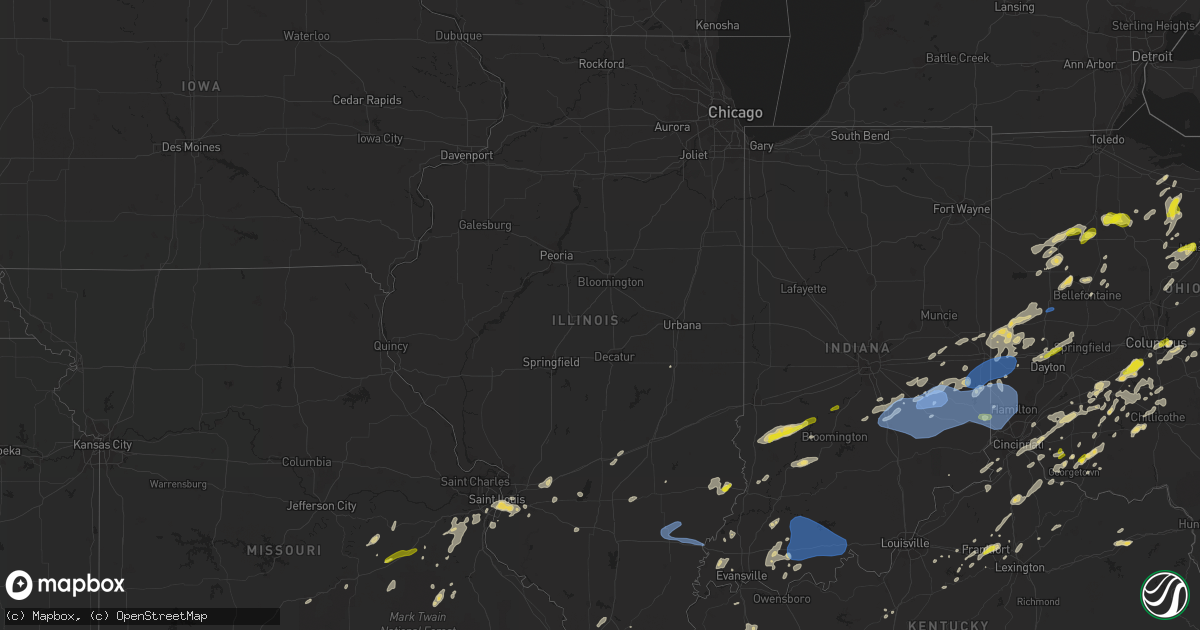
Hail Map in Illinois on May 21, 2022
Get this storm
May 21 map
$229
one time, instant access
Download today. No call, no setup
Keep the $229
Bought the map and want the full workflow? Apply the entire $229 to a subscription within 7 days. None of it is wasted.
Every map, not just this one
This buys you this map. Subscription and you get every map we run, in the markets you choose from a few cities to whole states to nationwide. Plus real-time alerts the moment a storm fires.
Contact data
Name, contact info, occupancy, even credit band for addresses in the footprint. You go from where it hit to who to call.
Become the source they trust
Unlimited branding weather history reports on demand. You already have the documented answer ready for the property owner, and you are the one who showed up with it.
Property data and RoofTrace estimates
Pull up any address you have got, its value and the exact code rules for that jurisdiction, straight from One Click Code. Then RoofTrace estimates the squares, pitch, and roof value, priced the way you price.
Storm reports in Illinois
Illinois
| Date | Description |
|---|---|
| 05/21/202212:56 PM CDT | A local report indicates 61 MPH wind near 3 E CARMI |
| 05/21/202211:15 AM CDT | A few trees snapped or uprooted and large limbs blown down... A few houses with shingle damage... And one house with roof damage. |
| 05/20/20228:56 PM CDT | At 155 PM CDT, a severe thunderstorm was located over Brookport, or near Paducah, moving northeast at 30 mph. HAZARD...Quarter size hail. SOURCE...Radar indicated. IMPACT...Damage to vehicles is expected. This severe thunderstorm will be near... Brookport around 205 PM CDT.Other locations in the path of this severe thunderstorm include Burnaand Joy.This includes the following highways... Interstate 24 in Kentucky between Mile Markers 1 and 12. Interstate 24 in Illinois between Mile Markers 34 and 38. |
All States Impacted by Hail Map on May 21, 2022
Cities Impacted by Hail Map on May 21, 2022
- Tunica, MS
- Lake Cormorant, MS
- Robinsonville, MS
- Hernando, MS
- Saint Albans, VT
- Sheldon, VT
- Swanton, VT
- Morrisville, VT
- Hyde Park, VT
- Wapakoneta, OH
- Bedford, OH
- Gates Mills, OH
- Rome, OH
- Chesterland, OH
- Orwell, OH
- Windsor, OH
- Chagrin Falls, OH
- Novelty, OH
- Macedonia, OH
- Newbury, OH
- Cleveland, OH
- Beachwood, OH
- Burton, OH
- Solon, OH
- Montville, OH
- Mentor, OH
- Willoughby, OH
- Chardon, OH
- Thompson, OH
- Huntsburg, OH
- Middlefield, OH
- Painesville, OH
- Warsaw, OH
- Columbus, OH
- Reynoldsburg, OH
- Laquey, MO
- Richland, MO
- Foster, KY
- Falmouth, KY
- Butler, KY
- Sycamore, OH
- Findlay, OH
- Carey, OH
- Upper Sandusky, OH
- Vanlue, OH
- McCutchenville, OH
- Mount Blanchard, OH
- Alvada, OH
- Arlington, OH
- New Riegel, OH
- Rock Creek, OH
- Independence, OH
- Maple Heights, OH
- Grove City, OH
- Orient, OH
- Bloomingburg, OH
- Washington Court House, OH
- Mount Sterling, OH
- London, OH
- Mount Perry, OH
- Rosebud, MO
- Gerald, MO
- Millersport, OH
- Baltimore, OH
- Central Square, NY
- Pennellville, NY
- West Monroe, NY
- Brewerton, NY
- Constantia, NY
- Saint Clair, MI
- East China, MI
- Clarks Mills, PA
- Fredonia, PA
- Greenville, PA
- Stoneboro, PA
- Conneautville, PA
- Alliance, OH
- Louisville, OH
- Ashtabula, OH
- Geneva, OH
- Austinburg, OH
- Jefferson, OH
- Parish, NY
- Clyde, OH
- Bellevue, OH
- Fresno, OH
- Errol, NH
- Canaan, VT
- Colebrook, NH
- Guildhall, VT
- Chillicothe, OH
- Circleville, OH
- Kingston, OH
- Lynn, IN
- Williamsburg, IN
- Republic, OH
- Derby Line, VT
- New Castle, IN
- Pleasantville, OH
- Russellville, OH
- Paris, KY
- Cynthiana, KY
- North Jackson, OH
- Youngstown, OH
- Lorain, OH
- Lewis, NY
- Williston, VT
- Keeseville, NY
- South Burlington, VT
- Willsboro, NY
- Shelburne, VT
- New Knoxville, OH
- Saint Marys, OH
- Forestport, NY
- Jeromesville, OH
- Mount Victory, OH
- Ridgeway, OH
- Kenton, OH
- Orleans, VT
- Almont, MI
- Flat Rock, IN
- Edinburgh, IN
- Shelbyville, IN
- Columbus, IN
- Eastlake, OH
- Derby, VT
- New Carlisle, OH
- Saint Paris, OH
- Clayton, OH
- Brookville, OH
- Dayton, OH
- North Hampton, OH
- Springfield, OH
- Englewood, OH
- Vandalia, OH
- Tipp City, OH
- Ellicottville, NY
- Franklinville, NY
- Great Valley, NY
- Pierpont, OH
- Conneaut, OH
- Kingsville, OH
- North Bloomfield, OH
- Louisville, IL
- Lake Milton, OH
- Berlin Center, OH
- Diamond, OH
- Fulton, NY
- Phoenix, NY
- Rouses Point, NY
- Centerville, IN
- Milton, IN
- Island Pond, VT
- Pittsburg, NH
- Norton, VT
- West Charleston, VT
- Averill, VT
- Andover, ME
- East Charleston, VT
- Morgan, VT
- Cuba, MO
- Atlantic, PA
- Cochranton, PA
- Meadville, PA
- Conneaut Lake, PA
- Potosi, MO
- Sullivan, MO
- House Springs, MO
- Arnold, MO
- Imperial, MO
- Fenton, MO
- High Ridge, MO
- Franklin, IN
- Trafalgar, IN
- Nineveh, IN
- Essex, NY
- West Alexandria, OH
- Sodus, NY
- Williamson, NY
- Mount Gilead, OH
- Galion, OH
- Edison, OH
- Baltic, OH
- Hillsboro, OH
- Waterford, PA
- Cambridge Springs, PA
- Germanton, NC
- Walnut Cove, NC
- Williamstown, KY
- New Wilmington, PA
- Pulaski, PA
- West Middlesex, PA
- Wirtz, VA
- Hardy, VA
- Stamping Ground, KY
- Conesville, OH
- Coshocton, OH
- Bourbon, MO
- Fincastle, VA
- Troutville, VA
- Boones Mill, VA
- Rocky Mount, VA
- O'Fallon, IL
- Belleville, IL
- Canal Winchester, OH
- Pataskala, OH
- Pickerington, OH
- Groveport, OH
- Lockbourne, OH
- Sabina, OH
- Troutdale, VA
- Sugar Grove, VA
- Burlington, KY
- Murfreesboro, NC
- Pendleton, NC
- Saint James, MO
- Saint Elmo, IL
- Troy, TN
- Hornbeak, TN
- Ridgely, TN
- Union City, TN
- Tiptonville, TN
- Obion, TN
- Williamsburg, OH
- Bethel, OH
- Frankfort, KY
- Roxboro, NC
- Timberlake, NC
- Batavia, OH
- Bahama, NC
- Imboden, AR
- Pocahontas, AR
- Greensburg, IN
- Milroy, IN
- Dover, TN
- Waverly, TN
- Hazel, KY
- Springville, TN
- Tennessee Ridge, TN
- Camden, TN
- Stewart, TN
- Mansfield, TN
- Cumberland City, TN
- Erin, TN
- Henry, TN
- Paris, TN
- Hollow Rock, TN
- New Concord, KY
- Big Sandy, TN
- Bruceton, TN
- Buchanan, TN
- Puryear, TN
- Whiteville, TN
- Iuka, IL
- Oil Trough, AR
- Pleasant Plains, AR
- Vienna, IL
- Cypress, IL
- Jonesboro, AR
- Princeton, NC
- Kenly, NC
- Selma, NC
- Canton, NC
- Waynesville, NC
- Heber Springs, AR
- McNeil, AR
- Waldo, AR
- Carlisle, AR
- Humnoke, AR
- Stuttgart, AR
- Batesville, AR
- Floral, AR
- Pulaski, TN
- Memphis, TN
- Swifton, AR
- Marshall, NC
- Louin, MS
- Cosby, TN
- Grandview, TX
- Piney Flats, TN
- Blountville, TN
- Johnson City, TN
- Kinston, AL
- Millen, GA
- Garfield, GA
- Midville, GA
- Marion, KY
- Salem, KY
- Fredonia, KY
- Burna, KY
- Eddyville, KY
- Princeton, KY
- Violet Hill, AR
- Salem, AR
- Hardy, AR
- Cherokee Village, AR
- Melbourne, AR
- Oxford, AR
- Franklin, AR
- Wiseman, AR
- Ash Flat, AR
- Glencoe, AR
- Horseshoe Bend, AR
- Brockwell, AR
- Lorena, TX
- Eva, TN
- McKenzie, TN
- Williamsville, MO
- Lewisburg, TN
- Clinton, KY
- Prospect, TN
- Lexington, NC
- Unionville, TN
- Wilburn, AR
- Saint Joe, AR
- Marshall, AR
- Oxford, NC
- Leicester, NC
- Fort Campbell, KY
- Oak Grove, KY
- Searcy, AR
- Poplar Bluff, MO
- Grandin, MO
- Ellsinore, MO
- Chuckey, TN
- Limestone, TN
- Buena Vista, TN
- Osceola, AR
- Mountain View, AR
- Pleasant Grove, AR
- Vilas, NC
- Sulphur Rock, AR
- Cord, AR
- Norman, AR
- Turbeville, SC
- Olanta, SC
- Horatio, AR
- Winthrop, AR
- Pine Bluff, AR
- McBee, SC
- Hattiesburg, MS
- Petal, MS
- Eagletown, OK
- Mena, AR
- Cabot, AR
- Cope, SC
- Anderson, AL
- Athens, AL
- Rogersville, AL
- Lester, AL
- Elkmont, AL
- Fort Mill, SC
- Kilgore, TX
- Overton, TX
- Humphrey, AR
- Aiken, SC
- Waxahachie, TX
- Hampton, AR
- Ovett, MS
- Ellisville, MS
- Hartsville, SC
- Rocky Ford, GA
- Nashville, AR
- Letohatchee, AL
- Fort Deposit, AL
- Hayneville, AL
- Springhill, LA
- West Mansfield, OH
- Mansfield, OH
- Davisburg, MI
- Shelbyville, KY
- East Carondelet, IL
- Dupo, IL
- East Saint Louis, IL
- Millstadt, IL
- Fairview Heights, IL
- Saint Louis, MO
- Petersburg, IN
- Winslow, IN
- Morehead, KY
- Carlisle, KY
- Charles City, VA
- Riner, VA
- Willis, VA
- Check, VA
- Indian Valley, VA
- Pilot, VA
- Floyd, VA
- Radford, VA
- Deerfield, OH
- Petersburg, WV
- Moorefield, WV
- Bruceville, IN
- Bicknell, IN
- Galena, MO
- Laurel Fork, VA
- Hillsville, VA
- Dickson, TN
- Burns, TN
- Danbury, NC
- Westfield, NC
- Bethel, NC
- Selmer, TN
- Ramer, TN
- Fremont, NC
- Stantonsburg, NC
- Wilson, NC
- Elkin, NC
- Roaring River, NC
- Ronda, NC
- Thurmond, NC
- State Road, NC
- North Wilkesboro, NC
- Lawrenceburg, TN
- Loretto, TN
- Leoma, TN
- Chester, SC
- Grand Junction, TN
- Michigan City, MS
- Moscow, TN
- Cordova, SC
- Texarkana, AR
- Proctor, AR
- Edmondson, AR
- Hughes, AR
- Aviston, IL
- Hot Springs Village, AR
- Lonsdale, AR
- Benton, AR
- Owensville, IN
- Princeton, IN
- Chrisney, IN
- Gentryville, IN
- Hot Springs National Park, AR
- North Tazewell, VA
- Umpire, AR
- Langley, AR
- Newhope, AR
- Jeffersonville, OH
- Wilmington, OH
- Jamestown, OH
- New Richmond, OH
- Cincinnati, OH
- Amelia, OH
- Cameron, SC
- Orangeburg, SC
- Elloree, SC
- Patriot, IN
- Rising Sun, IN
- Union, KY
- Oxford, OH
- College Corner, OH
- Somerville, OH
- Camden, OH
- Minter, AL
- Orrville, AL
- Carson, VA
- Dewitt, VA
- Dinwiddie, VA
- Saint Francisville, IL
- Lawrenceville, IL
- Sumner, IL
- Bridgeport, IL
- Claremont, IL
- Lansing, NC
- Creston, NC
- Greenfield, OH
- Leesburg, OH
- Marion, VA
- Suffolk, VA
- Sparta, KY
- Warsaw, KY
- Glencoe, KY
- Carlyle, IL
- Lawrenceburg, KY
- Locust Grove, AR
- Rosie, AR
- Sardinia, OH
- Lynchburg, OH
- Mount Orab, OH
- Elk Horn, KY
- Cecilia, KY
- Glendale, KY
- Linesville, PA
- Andover, OH
- Dorset, OH
- Drummonds, TN
- North Little Rock, AR
- Little Rock, AR
- Sunbury, OH
- Centerburg, OH
- Liberty, KY
- Success, AR
- Felicity, OH
- Ozan, AR
- Mineral Springs, AR
- Lockesburg, AR
- Columbus, AR
- Dittmer, MO
- Catawissa, MO
- Hillsboro, MO
- Pacific, MO
- Robertsville, MO
- Richwoods, MO
- Eureka, MO
- Cedar Hill, MO
- Guion, AR
- Mount Pleasant, AR
- Fulton, AR
- Ashdown, AR
- Meridian, MS
- Ore City, TX
- Blytheville, AR
- Safford, AL
- Dyer, TN
- Trenton, TN
- Martin, TN
- Ravenden Springs, AR
- Warm Springs, AR
- Goldsboro, NC
- Crawfordsville, AR
- Marion, AR
- Wakefield, VA
- Carrsville, VA
- Franklin, VA
- Zuni, VA
- Sedley, VA
- Courtland, VA
- Ivor, VA
- Hagarville, AR
- Dover, AR
- Compton, AR
- Lamar, AR
- Clarksville, AR
- Somerville, TN
- New London, NC
- Mount Pleasant, NC
- Albemarle, NC
- Dierks, AR
- Augusta, AR
- Bald Knob, AR
- Summerton, SC
- Rosston, AR
- Conway, AR
- Bigelow, AR
- Hot Springs, NC
- Stephens, AR
- Magnolia, AR
- Marked Tree, AR
- Lepanto, AR
- Jackman, ME
- Robards, KY
- Newark, AR
- Corydon, KY
- Henderson, KY
- Perryville, AR
- Roland, AR
- Paron, AR
- Jessieville, AR
- Elizabethtown, KY
- Manilla, IN
- Columbia, SC
- Tuscola, IL
- Seaman, OH
- Winchester, OH
- Georgetown, OH
- Iron City, TN
- Florence, AL
- Madisonville, KY
- Nortonville, KY
- White Plains, KY
- Graham, KY
- Earlington, KY
- Mortons Gap, KY
- Hatfield, AR
- Toomsuba, MS
- Frankfort, OH
- Nebo, KY
- Manitou, KY
- Livingston, AL
- Emelle, AL
- Princeton, WV
- South Salem, OH
- Dale, IN
- Lincoln City, IN
- Stendal, IN
- Boonville, IN
- Tennyson, IN
- Wickliffe, OH
- Rougemont, NC
- Aulander, NC
- Morgantown, IN
- Nashville, IN
- Whitetop, VA
- Mouth Of Wilson, VA
- Makanda, IL
- Cobden, IL
- Goreville, IL
- Carbondale, IL
- Hampshire, TN
- Scott City, MO
- Benton, MO
- Oran, MO
- Thebes, IL
- Chaffee, MO
- Culleoka, TN
- Thompsons Station, TN
- College Grove, TN
- Franklin, TN
- China Grove, NC
- Landis, NC
- Kannapolis, NC
- Centerville, TN
- Evansville, IN
- Blair, SC
- Hooks, TX
- Doniphan, MO
- Brecksville, OH
- Northfield, OH
- Johnson, VT
- Afton, TN
- Greeneville, TN
- Scott, AR
- Huntsville, OH
- Rushsylvania, OH
- Belle Center, OH
- Bellefontaine, OH
- Arcanum, OH
- West Milton, OH
- Laura, OH
- Ludlow Falls, OH
- Corinth, MS
- Huntsville, AR
- Berryville, AR
- Kosse, TX
- Marlin, TX
- Benton, LA
- Belcher, LA
- Como, NC
- Witter, AR
- State Line, MS
- Crestline, OH
- Tiro, OH
- Bentonia, MS
- Canton, MS
- Vaughan, MS
- Flag Pond, TN
- Fouke, AR
- West Memphis, AR
- New Haven, MI
- Macomb, MI
- New Baltimore, MI
- Jackson, TN
- Kirby, AR
- North Troy, VT
- Newport Center, VT
- Newport, VT
- Cherokee, AL
- Barton, VT
- Caseyville, IL
- Midlothian, TX
- Thornton, TX
- Hanson, KY
- Sebree, KY
- Slaughters, KY
- Hamilton, TX
- Jonesboro, TX
- Clifton, TX
- Cranfills Gap, TX
- Hico, TX
- Patton, MO
- Russia, OH
- Eaton, OH
- West Manchester, OH
- Covington, OH
- Fort Loramie, OH
- New Paris, OH
- Greenville, OH
- Pitsburg, OH
- Lewisburg, OH
- Eldorado, OH
- Richmond, IN
- Fountain City, IN
- New Madison, OH
- Palestine, OH
- Versailles, OH
- Hollansburg, OH
- Sidney, OH
- Piqua, OH
- Gettysburg, OH
- Bradford, OH
- Houston, OH
- Douglassville, TX
- Advance, MO
- Solsberry, IN
- Spencer, IN
- Tiffin, OH
- Bloomville, OH
- Saint Regis Falls, NY
- Potsdam, NY
- Bardstown, KY
- Bloomfield, KY
- Mineral Point, MO
- Valley Head, WV
- Durham, NC
- Hillsborough, NC
- Smithfield, VA
- Georgetown, KY
- Green Forest, AR
- Rushville, IN
- Finchville, KY
- Fisherville, KY
- Henrico, NC
- Valentines, VA
- Lenoir, NC
- Dongola, IL
- Buncombe, IL
- Marengo, OH
- Fulton, OH
- Ashley, OH
- Cardington, OH
- Summertown, TN
- Ethridge, TN
- Cottage Grove, TN
- Corning, AR
- Mountain Pine, AR
- King, NC
- Newberry, SC
- Scottsboro, AL
- Dyersburg, TN
- Newbern, TN
- Brickeys, AR
- Amity, AR
- Glenwood, AR
- Claudville, VA
- Mount Airy, NC
- Ararat, VA
- Pomaria, SC
- Cayce, SC
- Gaston, SC
- Hopkins, SC
- West Columbia, SC
- Maynard, AR
- Walls, MS
- Mullin, TX
- Eddy, TX
- Clayton Lake, ME
- Enosburg Falls, VT
- Berlin, NH
- Lobelville, TN
- Oakboro, NC
- Jasper, AR
- Spring Lake, NC
- Dyess, AR
- Tyronza, AR
- Goodspring, TN
- Waldron, IN
- Saint Joseph, TN
- Killen, AL
- Five Points, TN
- Muscle Shoals, AL
- Minor Hill, TN
- Lexington, AL
- Watson, OK
- Laurinburg, NC
- Gibson, NC
- McColl, SC
- Clio, SC
- Maxton, NC
- Little Rock, SC
- Horse Cave, KY
- Cave City, KY
- Tallassee, AL
- Decatur, MS
- Hickory, MS
- Enterprise, MS
- Rose Hill, MS
- Newton, MS
- Quitman, MS
- Stonewall, MS
- Pachuta, MS
- Modoc, IN
- Hagerstown, IN
- Economy, IN
- Spiceland, IN
- Knightstown, IN
- Rockport, IN
- Shady Valley, TN
- Rural Retreat, VA
- Windsor, VA
- Trimble, TN
- Kenton, TN
- Duck River, TN
- Hohenwald, TN
- Linden, TN
- Tarboro, NC
- Greenville, NC
- Salisbury, NC
- Adamsville, TN
- Crump, TN
- Ratcliff, AR
- Cardwell, MO
- Arbyrd, MO
- Columbia, TN
- Algonac, MI
- Fair Haven, MI
- Marine City, MI
- Harsens Island, MI
- London, AR
- Russellville, AR
- Delaware, AR
- Carroll, OH
- Rock Hill, SC
- Caddo Gap, AR
- Carlisle, SC
- Homer, IN
- Arlington, IN
- Morristown, IN
- Winnsboro, SC
- Richland Springs, TX
- San Saba, TX
- Marshall, TX
- Harleton, TX
- Jefferson, TX
- Highgate Center, VT
- Alburgh, VT
- Franklin, VT
- Clarksburg, OH
- New Holland, OH
- Williamsport, OH
- Newport, PA
- Millerstown, PA
- Ickesburg, PA
- Elliottsburg, PA
- Cook Sta, MO
- Steelville, MO
- Jonesborough, TN
- Telford, TN
- Lilbourn, MO
- Parma, MO
- Huntingdon, TN
- Greenbrier, AR
- Morrilton, AR
- Plumerville, AR
- Springfield, AR
- Solgohachia, AR
- Damascus, AR
- Troy, OH
- Holland, IN
- Huntingburg, IN
- Lawrenceville, VA
- Edgemont, AR
- Tumbling Shoals, AR
- Fairfield Bay, AR
- Prim, AR
- Drasco, AR
- Higden, AR
- Ida, AR
- Shirley, AR
- Concord, AR
- Greenfield, TN
- Gleason, TN
- Dresden, TN
- Mount Pleasant, TN
- Olive Hill, KY
- Maumelle, AR
- Little Rock Air Force Base, AR
- El Paso, AR
- Vilonia, AR
- Mayflower, AR
- Jacksonville, AR
- Sherwood, AR
- Spring Hill, TN
- Lewisville, IN
- Falmouth, IN
- Shelbyville, TN
- Poseyville, IN
- New Harmony, IN
- Wadesville, IN
- Mount Vernon, IN
- Cullowhee, NC
- Smithfield, NC
- Clayton, NC
- Taylorsville, KY
- Parsons, TN
- Decaturville, TN
- Munford, TN
- Millington, TN
- Saltillo, MS
- Baldwyn, MS
- New Albany, MS
- Blue Springs, MS
- Guntown, MS
- Tionesta, PA
- Marienville, PA
- Walton, KY
- Darlington, SC
- Midway, KY
- Murfreesboro, AR
- Newberry, IN
- Springville, IN
- Bloomfield, IN
- Owensburg, IN
- Scotland, IN
- Bishopville, SC
- Coldwater, MS
- Columbia, IL
- Valmeyer, IL
- De Queen, AR
- Kershaw, SC
- Texarkana, TX
- Queen City, TX
- Brownstown, IL
- Moro, AR
- Junction City, AR
- El Dorado, AR
- Connersville, IN
- Glenwood, IN
- Brownsville, IN
- Damascus, VA
- Chilhowie, VA
- Laurel Bloomery, TN
- Atlanta, TX
- Bloomburg, TX
- Bivins, TX
- Doddridge, AR
- Linden, TX
- Brownsboro, AL
- Huntsville, AL
- Owens Cross Roads, AL
- Dolphin, VA
- Rogersville, MO
- Fordland, MO
- Selma, AL
- Tyler, AL
- Freeman, VA
- Warfield, VA
- Spruce Pine, NC
- Marion, NC
- Elkton, KY
- Shell Knob, MO
- Blue Eye, MO
- Lampe, MO
- Deer, AR
- Polkton, NC
- Peachland, NC
- Charlotte, NC
- Sheridan, AR
- Redfield, AR
- Timbo, AR
- Fox, AR
- Windsor, NC
- Leesville, SC
- Batesburg, SC
- Alexander, AR
- Saratoga, AR
- New Edinburg, AR
- Neeses, SC
- Royal, AR
- Bonnerdale, AR
- Marshville, NC
- Hope, AR
- Manning, SC
- Dublin, TX
- Stephenville, TX
- Milan, GA
- Jacksonville, GA
- Rhine, GA
- Chilton, TX
- Peterman, AL
- McKenzie, AL
- Evergreen, AL
- Bainbridge, OH
- Highland, IL
- Saint Jacob, IL
- Marine, IL
- Smithland, KY
- Yorktown, VA
- Surry, VA
- Fort Eustis, VA
- Newport News, VA
- Hayes, VA
- Gloucester Point, VA
- Williamsburg, VA
- Norfork, AR
- Calico Rock, AR
- Flippin, AR
- Mountain Home, AR
- Quitman, AR
- Lynnville, TN
- Etowah, AR
- Newport, AR
- Tuckerman, AR
- Del Rio, TN
- Hartford, TN
- Newport, TN
- Portageville, MO
- Hayti, MO
- Eureka Springs, AR
- Bridgeport, AL
- Richburg, SC
- Great Falls, SC
- Pearcy, AR
- Bismarck, AR
- Whitmire, SC
- Hephzibah, GA
- Eutaw, AL
- Adrian, GA
- Soperton, GA
- Lancaster, NH
- Boonville, NY
- Port Leyden, NY
- Constableville, NY
- Lima, OH
- Bucyrus, OH
- Caledonia, OH
- Harrison Township, MI
- Ashville, OH
- Loveland, OH
- Pleasant Plain, OH
- Maineville, OH
- Ft Mitchell, KY
- Clarksville, OH
- Morrow, OH
- Latonia, KY
- Blanchester, OH
- Newport, KY
- Martinsville, OH
- Midland, OH
- Fort Thomas, KY
- Goshen, OH
- New Vienna, OH
- Milford, OH
- Maplewood, OH
- Jackson Center, OH
- Lakeview, OH
- Lewistown, OH
- Waddy, KY
- Edwardsport, IN
- California, KY
- Alexandria, KY
- Caledonia, MO
- Belleview, MO
- Belgrade, MO
- Roseland, VA
- Lovingston, VA
- Brenton, WV
- Bagdad, KY
- Munfordville, KY
- Hiwassee, VA
- Dugspur, VA
- Mount Eden, KY
- Roanoke, VA
- West Forks, ME
- Vienna, OH
- Niles, OH
- Girard, OH
- Worthington, IN
- Hymera, IN
- Shelburn, IN
- Coalmont, IN
- Coal City, IN
- Jasonville, IN
- Lewis, IN
- Freedom, IN
- Sullivan, IN
- Clay City, IN
- Mountain City, TN
- Smithville, AR
- Strawberry, AR
- Poughkeepsie, AR
- Ravenden, AR
- Black Rock, AR
- Evening Shade, AR
- Williford, AR
- McEwen, TN
- Brookport, IL
- Golconda, IL
- Plymouth, OH
- Willard, OH
- Monroeville, OH
- Attica, OH
- New Washington, OH
- Ontario, NY
- Stuart, VA
- Bethpage, TN
- Gallatin, TN
- Mammoth Spring, AR
- Liberty, IN
- Brookville, IN
- Apex, NC
- Cary, NC
- Morrisville, NC
- Pettigrew, AR
- Kansas, OK
- Delphos, OH
- Pandora, OH
- Forest, OH
- Columbus Grove, OH
- Cairo, OH
- Mount Cory, OH
- Bluffton, OH
- Jenera, OH
- Rawson, OH
- Spencerville, OH
- Ada, OH
- Mason, TN
- La Crosse, VA
- Brodnax, VA
- Williamsport, TN
- Edgemoor, SC
- Delaplaine, AR
- Hoxie, AR
- Peach Orchard, AR
- Marmaduke, AR
- Alicia, AR
- Knobel, AR
- Paragould, AR
- Bono, AR
- Walnut Ridge, AR
- Beech Grove, AR
- Piggott, AR
- Biggers, AR
- Lafe, AR
- Rector, AR
- Cash, AR
- O'Kean, AR
- Yadkinville, NC
- Mocksville, NC
- Stamps, AR
- Taylor, AR
- Fall Branch, TN
- Franklin, TX
- Cooter, MO
- Saint Francis, AR
- Gobler, MO
- Caruthersville, MO
- Holcomb, MO
- Catron, MO
- Senath, MO
- Bragg City, MO
- Wardell, MO
- Finley, TN
- Kennett, MO
- Steele, MO
- Clarkton, MO
- Campbell, MO
- Malden, MO
- Greenway, AR
- Hornersville, MO
- Gideon, MO
- Manila, AR
- Leachville, AR
- Lenox, TN
- Forsyth, GA
- Nashville, IL
- Dresden, OH
- South Boston, VA
- Yanceyville, NC
- Burlington, NC
- Byhalia, MS
- Holly Springs, MS
- Red Banks, MS
- Rutherford, TN
- Prescott, AR
- Mayfield, KY
- Lynchburg, SC
- Hickman, KY
- New Madrid, MO
- Rives, TN
- East Prairie, MO
- Marston, MO
- Seminary, MS
- Jerusalem, AR
- Cleveland, AR
- New Blaine, AR
- Witts Springs, AR
- Scranton, AR
- Atkins, AR
- Clinton, AR
- Dennard, AR
- Choctaw, AR
- Center Ridge, AR
- Pelsor, AR
- Bee Branch, AR
- Hattieville, AR
- Hector, AR
- Leslie, AR
- Tilly, AR
- Scotland, AR
- Ozone, AR
- Stanton, TN
- Beebe, AR
- Northport, AL
- Oakman, AL
- Brookwood, AL
- Quinton, AL
- Bessemer, AL
- Adger, AL
- Norwood, NC
- Waco, TX
- Jackson, AL
- Frenchmans Bayou, AR
- Arlington, TN
- Turrell, AR
- Vandervoort, AR
- Cove, AR
- Wickes, AR
- Elgin, SC
- Fairfax, SC
- Allendale, SC
- Ozark, IL
- West Harrison, IN
- New Trenton, IN
- Cedar Grove, IN
- Madison, IN
- Blackwell, MO
- Fletcher, MO
- Amherst, VA
- Alexandria, OH
- Granville, OH
- Perrysville, OH
- Butler, OH
- Mercer, PA
- Owensville, MO
- Bland, MO
- Belle, MO
- Grundy, VA
- Big Rock, VA
- Bell City, MO
- Chaplin, KY
- Nunda, NY
- Portageville, NY
- Fillmore, NY
- Dalton, NY
- Hunt, NY
- Bismarck, MO
- Irondale, MO
- Lawsonville, NC
- Kevil, KY
- Metropolis, IL
- Melber, KY
- Paducah, KY
- Hickory, KY
- Symsonia, KY
- Arlington, KY
- Bardwell, KY
- West Paducah, KY
- Fancy Farm, KY
- Cunningham, KY
- Wickliffe, KY
- La Center, KY
- Ledbetter, KY
- Barlow, KY
- Boaz, KY
- Trenton, KY
- Mount Judea, AR
- Clyde, NC
- Newburg, MO
- West College Corner, IN
- Meridian, TX
- Iredell, TX
- Waynesfield, OH
- Twin City, GA
- Palestine, TX
- Richmond, MI
- Casco, MI
- Corry, PA
- Corinth, KY
- Owenton, KY
- Jamestown, PA
- Kinsman, OH
- Milan, NH
- Miller City, IL
- Union City, PA
- Glenford, OH
- Somerset, OH
- Thornville, OH
- Matthews, MO
- Hamersville, OH
- Sharon, TN
- Grandview, IN
- Evanston, IN
- Lamar, IN
- Augusta, KY
- Vendor, AR
- Parthenon, AR
- Hasty, AR
- Western Grove, AR
- Reagan, TN
- Enville, TN
- Milledgeville, TN
- Sardis, TN
- Bath Springs, TN
- Scotts Hill, TN
- Saltillo, TN
- Pocahontas, TN
- Wilson, AR
- Joiner, AR
- Houston, AR
- England, AR
- Hensley, AR
- Comanche, TX
- Nesbit, MS
- Thomasville, AL
- Sweet Water, AL
- Doyline, LA
- Sibley, LA
- Valley Mills, TX
- Crawford, TX
- Riesel, TX
- Evant, TX
- Lometa, TX
- Purmela, TX
- Goldthwaite, TX
- Gatesville, TX
- Lampasas, TX
- Star, TX
- Denmark, SC
- Bamberg, SC
- Catherine, AL
- McGregor, TX
- Camden, AL
- Rowesville, SC
- Branchville, SC
- Caldwell, TX
- Gainesville, AL
- Epes, AL
- Dallas, TX
- Marietta, TX
- Mexia, TX
- Wortham, TX
- Mart, TX
- Axtell, TX
- Moody, TX
- Diana, TX
- May, TX
- Mount Calm, TX
- Prairie Hill, TX
- Rodessa, LA
- Ida, LA
- Lohn, TX
- Lott, TX
- Reagan, TX
- Rosebud, TX
- Maypearl, TX
- Tyler, TX
- Whitehouse, TX
- Collins, MS
- Plain Dealing, LA
- Macon, GA
- Dry Branch, GA
- Eatonton, GA
- Forest Home, AL
- McRae Helena, GA
- Woodway, TX
- Musella, GA
- Roberta, GA
- Knoxville, GA
- Leakesville, MS
- New Augusta, MS
- Richton, MS
- Bradley, AR
- Longview, TX
- Alberta, AL
- Vinegar Bend, AL
- Buckner, AR
- Italy, TX
- Mize, MS
- Seagoville, TX
- Mesquite, TX
- Bay Springs, MS
- Brooker, FL
- Gause, TX
- Sterrett, AL
- Vincent, AL
- Chelsea, AL
- Wilsonville, AL
- Columbiana, AL
- Harpersville, AL
- Lauderdale, MS
- Pine Apple, AL
- Moselle, MS
- Hosston, LA
- Spicewood, TX
- Hockley, TX
- Boerne, TX
- West, TX
- Elm Mott, TX
- Cadwell, GA
- Falls City, TX
- Smackover, AR
- Monticello, GA
- Quemado, TX
- Bertram, TX
- Burnet, TX
- Perkinston, MS
- Yulee, FL
- Moore, TX
- Devine, TX
- Charlotte, TX
- Bigfoot, TX
- Pearsall, TX
- Jourdanton, TX
- Pleasanton, TX
- McDade, TX
- Del Rio, TX
- Laughlin Afb, TX
- Brackettville, TX
- Brooksville, FL
- Leakey, TX
- Punta Gorda, FL
- Arcadia, FL
- Sonora, TX
- Lake City, FL
- Wellborn, FL
- McAlpin, FL
- Lumberton, MS
- Luling, TX
- Brady, TX
- Plant City, FL
- Gainesville, FL
- Bay Minette, AL
- Pierson, FL
- Bunnell, FL
- Seville, FL
- Comfort, TX
- Lakeland, FL
- Bartow, FL
- Fort Meade, FL
- Ehrhardt, SC
- Hubbard, TX
- Dawson, TX
- Oviedo, FL
- Hunt, TX
- Kendalia, TX
- Medina, TX
- Leesburg, FL
- Clermont, FL
- Tavares, FL
- Howey In The Hills, FL
- Astatula, FL
- Mount Dora, FL
- La Coste, TX
- San Antonio, TX
- Lytle, TX
- Somerset, TX
- Castroville, TX
- Atascosa, TX
- Hearne, TX
- Calvert, TX
- Cameron, TX
- Junction, TX
- Saint Johns, FL
- Orange City, FL
- De Leon Springs, FL
- Deland, FL
- Mountain Home, TX
- Harper, TX
- Mason, TX
- Flatonia, TX
- Lewisville, AR
- Jacksonville, FL
- Milano, TX
- Dime Box, TX
- Giddings, TX
- Green Cove Springs, FL
- Gloster, MS
- Centreville, MS
- Saint Francisville, LA
- Woodville, MS
- Eustis, FL
- Geneva, FL
- Orlando, FL
- Marble Falls, TX
- Austin, TX
- Leander, TX
- Sorrento, FL
- Saint Augustine, FL
- La Pryor, TX
- Alva, FL
- Johnson City, TX
- Blanco, TX
- Dripping Springs, TX
- Wimberley, TX
- Crystal City, TX
- Camp Wood, TX
- Bandera, TX
- Utopia, TX
- Hondo, TX
- Batesville, TX
- D Hanis, TX
- Yancey, TX
- Barksdale, TX
- Rocksprings, TX
- Manor, TX
- Kountze, TX
- Myakka City, FL
- Lodge, SC
- Harwood, TX
- Lake Butler, FL
- Jasper, FL
- Ingram, TX
- New Braunfels, TX
- McQueeney, TX
- Kingsbury, TX
- Seguin, TX
- Richland, TX
- Corsicana, TX
- Rockdale, TX
- Lincoln, TX
- Baker, LA
- Baton Rouge, LA
- Spring Branch, TX
- Tuskegee, AL
- Hardaway, AL
- Jayess, MS
- Tylertown, MS
- Live Oak, FL
- White Springs, FL
- Mico, TX
- Pipe Creek, TX
- Tarpley, TX
- Kerrville, TX
- Vanderpool, TX
- O'Brien, FL
- Mount Hermon, LA
- Franklinton, LA
- Lexington, TX
- Orange Park, FL
- Middleburg, FL
- Blum, TX
- Covington, TX
- Rio Vista, TX
- Cleburne, TX
- Penelope, TX
- Purdon, TX
- Coolidge, TX
- Abbott, TX
- Oakwood, TX
- Buffalo, TX
- Fischer, TX
- Driftwood, TX
- Eagle Pass, TX
- Cibolo, TX
- Schertz, TX
- Laredo, TX
- Bryan, TX
- Concepcion, TX
- Robstown, TX
- Corpus Christi, TX
- Mathis, TX
- Sanford, FL
- Winter Springs, FL
- Dade City, FL
- Webster, FL
- Marion, TX
- Bulverde, TX
- Beaumont, MS
- Okeechobee, FL
- Winter Garden, FL
- Polk City, FL
- Bowling Green, FL
- Dilley, TX
- Zolfo Springs, FL
- Denham Springs, LA
- Brewton, AL
- Hext, TX
- Menard, TX
- Deltona, FL
- Spring Hill, FL
- Bradley, FL
- Hampton, FL
- Starke, FL
- La Vernia, TX
- Gonzales, TX
- Walker, LA
- Wauchula, FL
- Ona, FL
- Cuero, TX
- Elgin, TX
- Palatka, FL
- Rio Medina, TX
- Hawthorne, FL
- Muldoon, TX
- Schulenburg, TX
- Ormond Beach, FL
- Daytona Beach, FL
- Mineral Ridge, OH
- Altamont, IL
- Jacksonville Beach, FL
- Pine Level, NC
- Fairfield, TX
- Troup, TX
- Bullard, TX
- Rusk, TX
- Teague, TX
- Hallsville, TX
- Tennessee Colony, TX
- Jacksonville, TX
- Tatum, TX
- Carthage, TX
- Groesbeck, TX
- Selman City, TX
- Streetman, TX
- Price, TX
- Henderson, TX
- Beckville, TX
- Bergheim, TX
- Ponca, AR
- Mulga, AL
- Lyons Falls, NY
- Mooers Forks, NY
- North Rose, NY
- Martville, NY
- Red Creek, NY
- Lyons, NY
- Newark, NY
- Walworth, NY
- Marion, NY
- Clyde, NY
- Wolcott, NY
- Sterling, NY
- Harrisburg, OH
- Hiram, OH
- Warren, OH
- Southington, OH
- Adamsville, PA
- Streetsboro, OH
- Williamsfield, OH
- Farmdale, OH
- Fowler, OH
- Aurora, OH
- Twinsburg, OH
- Garrettsville, OH
- Hartstown, PA
- Mantua, OH
- Bristolville, OH
- Cortland, OH
- West Farmington, OH
- Transfer, PA
- Burghill, OH
- Windham, OH
- Hermitage, PA
- Brookfield, OH
- Wheatland, PA
- Sharon, PA
- Sharpsville, PA
- Masury, OH
- Hubbard, OH
- Farrell, PA
- Ewing, VA
- Jonesville, VA
- Rose Hill, VA
- Cooperstown, PA
- Oil City, PA
- Spartansburg, PA
- Pleasantville, PA
- Utica, PA
- Hydetown, PA
- Townville, PA
- Titusville, PA
- Centerville, PA
- Grand Valley, PA
- Carlton, PA
- Guys Mills, PA
- Tidioute, PA
- Pittsfield, PA
- Franklin, PA
- Spring Creek, PA
- Sandy Lake, PA
- Polk, PA
- Trumann, AR
- Austin, AR
- Martinsville, IN
- Paragon, IN
- Okeana, OH
- Sneedville, TN
- Golden Gate, IL
- Grayville, IL
- Barnhill, IL
- Fairfield, IL
- Albion, IL
- Celestine, IN
- Ferdinand, IN
- Saint Meinrad, IN
- Eckerty, IN
- Leopold, IN
- Schnellville, IN
- Dubois, IN
- Santa Claus, IN
- Sulphur, IN
- Leavenworth, IN
- Grantsburg, IN
- Branchville, IN
- English, IN
- Saint Croix, IN
- Jasper, IN
- Saint Anthony, IN
- Bristow, IN
- Birdseye, IN
- Taswell, IN
- Fairfield, OH
- Oldenburg, IN
- Seven Mile, OH
- Sunman, IN
- Hamilton, OH
- Clifford, IN
- Westport, IN
- Trenton, OH
- Hartsville, IN
- Batesville, IN
- Butlerville, IN
- Laurel, IN
- Cleves, OH
- Metamora, IN
- Bath, IN
- Harrison, OH
- Hope, IN
- Middletown, OH
- Saint Paul, IN
- Taylorsville, IN
- Osgood, IN
- Boston, IN
- Leasburg, MO
- Henning, TN
- Lake City, AR
- State University, AR
- Black Oak, AR
- Monette, AR
- Portia, AR
- Harrisburg, AR
- Bassett, AR
- Powhatan, AR
- Brookland, AR
- Sidney, AR
- Keiser, AR
- Caraway, AR
- Dell, AR
- Cave City, AR
- Gilmore, AR
- Lynn, AR
- Luxora, AR
- Saffell, AR
- Burlison, TN
- Weiner, AR
- Bay, AR
- Hazen, AR
- Lonoke, AR
- Grady, AR
- Yorktown, AR
- Star City, AR
- Kingsland, AR
- Monticello, AR
- Thornton, AR
- Rison, AR
- Warren, AR
- Banks, AR
- Fordyce, AR
- Wilmar, AR
- Ivan, AR
- De Witt, AR
- Almyra, AR
- Altheimer, AR
- Wabbaseka, AR
- Rochelle, TX
- Itasca, TX


