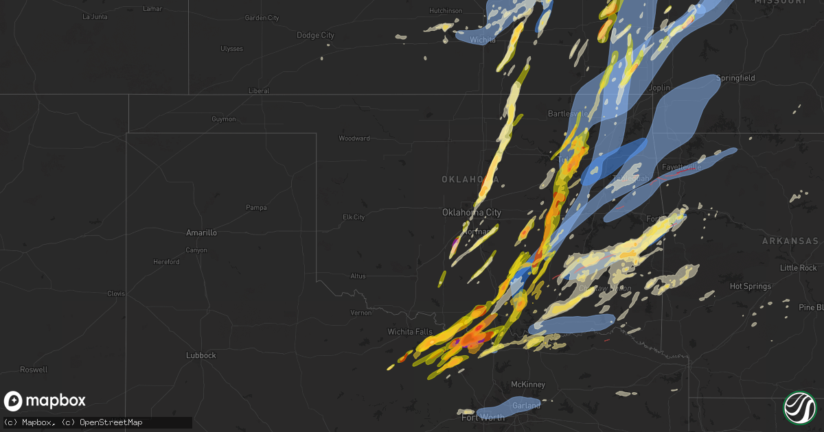
Hail Map in Oklahoma on May 19, 2025
Get this storm
May 19 map
$229
one time, instant access
Download today. No call, no setup
Keep the $229
Bought the map and want the full workflow? Apply the entire $229 to a subscription within 7 days. None of it is wasted.
Every map, not just this one
This buys you this map. Subscription and you get every map we run, in the markets you choose from a few cities to whole states to nationwide. Plus real-time alerts the moment a storm fires.
Contact data
Name, contact info, occupancy, even credit band for addresses in the footprint. You go from where it hit to who to call.
Become the source they trust
Unlimited branding weather history reports on demand. You already have the documented answer ready for the property owner, and you are the one who showed up with it.
Property data and RoofTrace estimates
Pull up any address you have got, its value and the exact code rules for that jurisdiction, straight from One Click Code. Then RoofTrace estimates the squares, pitch, and roof value, priced the way you price.
Storm reports in Oklahoma
Oklahoma
| Date | Description |
|---|---|
| 05/19/20256:50 PM CDT | A local report indicates 82 MPH wind near 4 ENE Cookson |
| 05/19/20256:50 PM CDT | Measured thunderstorm wind gust of 64 mph at the cookson mesonet. |
| 05/19/20256:48 PM CDT | Trained spotter measured thunderstorm wind gust to 64 mph at us highway 60 near intersection with highway 11. |
| 05/19/20256:47 PM CDT | Report from mping: quarter |
| 05/19/20256:46 PM CDT | A local report indicates 1.25 inch wind near 2 W Burbank |
| 05/19/20256:45 PM CDT | Large trees and power lines down near west lakewood drive and white raven road. Time estimated from radar. |
| 05/19/20256:45 PM CDT | Report from mping: half dollar |
| 05/19/20256:44 PM CDT | Tornado debris signature. |
| 05/19/20256:35 PM CDT | Measured thunderstorm wind gust of 58 mph at the wilburton mesonet. |
| 05/19/20256:30 PM CDT | A measured thunderstorm wind gust occurred at the webbers falls mesonet. |
| 05/19/20256:24 PM CDT | Tornado debris signature. |
| 05/19/20256:15 PM CDT | Tornado debris signature. |
| 05/19/20256:15 PM CDT | Report from mping: half dollar |
| 05/19/20255:56 PM CDT | A local report indicates 1.75 inch wind near 4 WSW Stillwater |
| 05/19/20255:53 PM CDT | Thunderstorm wind gust estimated to 60 mph at 428 and 630rd in choteau. |
| 05/19/20255:51 PM CDT | Tornado debris signature. |
| 05/19/20255:49 PM CDT | Nwschat report... Mainly pea sized hail with some golfballs. |
| 05/19/20255:41 PM CDT | Shingles blew off a house. |
| 05/19/20255:41 PM CDT | A local report indicates 1.00 inch wind near Coyle |
| 05/19/20255:37 PM CDT | Report from mping: quarter |
| 05/19/20255:27 PM CDT | A local report indicates 1.25 inch wind near 3 N Meridian |
| 05/19/20255:26 PM CDT | A local report indicates a tornado near 5 WSW Wardville |
| 05/19/20255:21 PM CDT | Reported through mping. |
| 05/19/20255:20 PM CDT | X post with photo. |
| 05/19/20255:18 PM CDT | Photo sent to eoc in edmond. |
| 05/19/20255:15 PM CDT | Trees downed onto powerlines off of mill street in ravia. |
| 05/19/20255:13 PM CDT | Report of trees down in south coffeyville. |
| 05/19/20255:02 PM CDT | A local report indicates 1.00 inch wind near 1 W Forest Park |
| 05/19/20254:58 PM CDT | Tree debris with tree on roadway on cr 1475. Time is radar estimate. |
| 05/19/20254:55 PM CDT | Measured thunderstorm wind gust of 62 mph at the copan mesonet. |
| 05/19/20254:54 PM CDT | Delayed report. Report from mping: quarter |
| 05/19/20254:52 PM CDT | Delayed report. Kokc. |
| 05/19/20254:49 PM CDT | On highway 76 just south of 32. |
| 05/19/20254:49 PM CDT | X photo with measurement. |
| 05/19/20254:48 PM CDT | Tree down in roadway at cr 3 drive and cr3580... Time is radar estimate. |
| 05/19/20254:46 PM CDT | Along highway 3w between stonewall and ahloso. |
| 05/19/20254:45 PM CDT | A local report indicates 1.00 inch wind near 8 SE Dewey |
| 05/19/20254:45 PM CDT | Estimated 55 mph wind gust as well. |
| 05/19/20254:45 PM CDT | A local report indicates 1.00 inch wind near Moore |
| 05/19/20254:40 PM CDT | Measured at ok mesonet site. |
| 05/19/20254:36 PM CDT | Reported on highway 76. |
| 05/19/20254:35 PM CDT | Measured thunderstorm wind gust of 66 mph at the talala mesonet. |
| 05/19/20254:28 PM CDT | Lots of quarter to ping pong hail observed. |
| 05/19/20254:28 PM CDT | A local report indicates 1.00 inch wind near 3 SE Collinsville |
| 05/19/20254:27 PM CDT | A local report indicates 1.75 inch wind near 3 NE Tulsa |
| 05/19/20254:26 PM CDT | Report from mping: ping pong ball |
| 05/19/20254:25 PM CDT | Measured thunderstorm wind gust of 67 mph at the skiatook mesonet. |
| 05/19/20254:23 PM CDT | A local report indicates 1.00 inch wind near Middleberg |
| 05/19/20254:22 PM CDT | A local report indicates 1.00 inch wind near 4 SW Vera |
| 05/19/20254:17 PM CDT | Reported at fire department. |
| 05/19/20254:17 PM CDT | A local report indicates 1.00 inch wind near 2 NW Verdigris |
| 05/19/20254:15 PM CDT | A local report indicates 1.00 inch wind near 5 E Owasso |
| 05/19/20254:13 PM CDT | Report of golf ball hail and tree limbs down at 31st and yale. |
| 05/19/20254:13 PM CDT | A local report indicates 1.25 inch wind near 3 E Owasso |
| 05/19/20254:12 PM CDT | Quarter size hail lasting approximately 4 minutes. Leaves ripped off trees. |
| 05/19/20254:12 PM CDT | A local report indicates 1.25 inch wind near 1 E Owasso |
| 05/19/20254:12 PM CDT | A local report indicates 1.00 inch wind near 1 S Skiatook |
| 05/19/20254:11 PM CDT | A local report indicates 1.50 inch wind near 1 S Skiatook |
| 05/19/20254:11 PM CDT | A local report indicates 1.50 inch wind near 4 W Verdigris |
| 05/19/20254:11 PM CDT | A local report indicates 1.00 inch wind near 3 E Owasso |
| 05/19/20254:10 PM CDT | A local report indicates 1.00 inch wind near 1 N Owasso |
| 05/19/20254:08 PM CDT | National weather service office @ 11th and highway 169. |
| 05/19/20254:06 PM CDT | A local report indicates 1.25 inch wind near 2 SW Tulsa |
| 05/19/20254:06 PM CDT | Measured thunderstorm wind gust of 64 mph at the tulsa asos. |
| 05/19/20254:06 PM CDT | Reported at lone grove city hall. |
| 05/19/20254:05 PM CDT | A local report indicates 1.50 inch wind near 2 N Tulsa |
| 05/19/20254:04 PM CDT | A local report indicates 1.00 inch wind near 4 NE Tulsa |
| 05/19/20254:03 PM CDT | A local report indicates 1.00 inch wind near 4 E Tulsa |
| 05/19/20254:03 PM CDT | A local report indicates 1.75 inch wind near 4 NW Broken Arrow |
| 05/19/20254:02 PM CDT | A local report indicates 1.25 inch wind near 2 NW Tulsa |
| 05/19/20254:02 PM CDT | Large tree and several large limbs down. Time estimated from radar. |
| 05/19/20254:01 PM CDT | A local report indicates 1.25 inch wind near 3 W Tulsa |
| 05/19/20254:01 PM CDT | A local report indicates 1.50 inch wind near 2 N Tulsa |
| 05/19/20254:00 PM CDT | A local report indicates 1.00 inch wind near 3 SW Tulsa |
| 05/19/20254:00 PM CDT | A local report indicates 1.00 inch wind near 3 E Glenpool |
| 05/19/20254:00 PM CDT | A local report indicates 1.25 inch wind near 2 E Tulsa |
| 05/19/20254:00 PM CDT | A local report indicates 1.50 inch wind near 5 E Tulsa |
| 05/19/20253:59 PM CDT | A local report indicates 1.25 inch wind near 3 SW Tulsa |
| 05/19/20253:58 PM CDT | A local report indicates 1.00 inch wind near 4 E Glenpool |
| 05/19/20253:57 PM CDT | A local report indicates 1.00 inch wind near 3 W Jenks |
| 05/19/20253:57 PM CDT | A local report indicates 1.75 inch wind near 4 SW Tulsa |
| 05/19/20253:57 PM CDT | A local report indicates 2.00 inch wind near 2 NE Jenks |
| 05/19/20253:56 PM CDT | Along highway 76 and to the north towards town. |
| 05/19/20253:56 PM CDT | A local report indicates 1.75 inch wind near 2 NE Jenks |
| 05/19/20253:56 PM CDT | A local report indicates 1.00 inch wind near 3 NW Broken Arrow |
| 05/19/20253:55 PM CDT | Numerous large tree limbs down throughout downtown and west sides of sapulpa. Time estimated from radar. |
| 05/19/20253:55 PM CDT | A local report indicates 1.25 inch wind near Jenks |
| 05/19/20253:53 PM CDT | A local report indicates 1.00 inch wind near Jenks |
| 05/19/20253:52 PM CDT | Nickel to quarter size hail at 71st and yale. |
| 05/19/20253:50 PM CDT | A local report indicates 1.00 inch wind near 3 E Jenks |
| 05/19/20253:48 PM CDT | A local report indicates 1.00 inch wind near Mounds |
| 05/19/20253:41 PM CDT | Aw. |
| 05/19/20253:38 PM CDT | Aw. |
| 05/19/20253:29 PM CDT | Photo in nwschat. |
| 05/19/20253:28 PM CDT | Tree down in road. Approximately 8 inch in diameter. |
| 05/19/20253:17 PM CDT | A local report indicates 1.75 inch wind near 1 E Seminole |
| 05/19/20253:13 PM CDT | A local report indicates 1.50 inch wind near Okemah |
| 05/19/20252:56 PM CDT | Spotternetwork report. |
| 05/19/20252:56 PM CDT | Spotternetwork report. |
| 05/19/20252:56 PM CDT | Spotternetwork report. |
| 05/19/20252:37 PM CDT | Report from mping: half dollar |
| 05/19/20252:36 PM CDT | Report from mping: quarter |
| 05/19/20252:31 PM CDT | Nwschat report. |
| 05/19/20252:28 PM CDT | Nwschat report. |
| 05/19/20252:15 PM CDT | A local report indicates 1.75 inch wind near 1 W Sulphur |
| 05/19/20252:13 PM CDT | Report from mping: quarter |
| 05/19/20252:12 PM CDT | A local report indicates 1.75 inch wind near 1 SW Sulphur |
| 05/19/20252:12 PM CDT | Report from mping: hen egg |
| 05/19/202512:21 PM CDT | Report from mping: half dollar |
| 05/19/202512:21 PM CDT | Report at 108th and maguire road. Time is radar estimated. |
| 05/19/20253:00 AM CDT | *** 1 inj *** tree fell on a home in the holly creek area. One occupant cut her head while exiting the home. All |
| 05/19/20253:00 AM CDT | *** 1 inj *** tree fell on a home in the holly creek area. One occupant cut her head while exiting the home. All other occupants were safe. |
| 05/19/20253:00 AM CDT | *** 1 inj *** tree fell on a home i |
| 05/19/20253:00 AM CDT | *** 1 inj *** tree fell on a home in the holly creek area. One occupant cut her head while e |
| 05/19/20253:00 AM CDT | *** 1 inj *** tree fell on a home in the holly creek area. One occupant cut her head while ex |
| 05/19/20253:00 AM CDT | *** 1 inj *** tree fell on a home in the holly creek area. One occupant cut her head while exiting |
| 05/19/20252:30 AM CDT | Trees down just north of the intersection of state highway 98 and state highway 37. |
| 05/19/20251:45 AM CDT | Measured by mesonet station. |
| 05/19/202512:20 AM CDT | Multiple trees down. Time estimated. |
| 05/19/202512:15 AM CDT | Delayed report. Trees and power lines blown down across portions of southern atoka county. Location is approximate and time is estimated from radar. |
| 05/19/202512:11 AM CDT | Near washington ave and mockingbird lane. |
| 05/19/202512:10 AM CDT | Multiple trees down around town. Some blocking roadways. Time estimated. |
| 05/18/202511:56 PM CDT | Near intersection of us hwy 70 and kirsey rd. |
| 05/18/202511:30 PM CDT | Trees downed on wheeler road northwest of valiant... Oklahoma. |
| 05/18/202511:11 PM CDT | Phone call report. |
| 05/18/20258:00 PM CDT | A local report indicates 64 MPH wind near 1 WSW Guymon |
| 05/18/20257:38 PM CDT | Tornado debris signature. |
| 05/18/20257:37 PM CDT | A local report indicates 1.00 inch wind near 1 E Spiro |
| 05/18/20257:28 PM CDT | A local report indicates 1.00 inch wind near 3 SW Hartshorne |
| 05/18/20257:22 PM CDT | Tornado debris signature. |
| 05/18/20257:20 PM CDT | Mesonet station good goodwell. |
| 05/18/20257:18 PM CDT | A local report indicates 1.00 inch wind near 1 E Spiro |
| 05/18/20257:16 PM CDT | Relayed through nwschat. |
| 05/18/20257:00 PM CDT | Tornado debris signature. |
All States Impacted by Hail Map on May 19, 2025
Cities Impacted by Hail Map on May 19, 2025
- Augusta, AR
- McCrory, AR
- Cotton Plant, AR
- Hunter, AR
- Palestine, AR
- Colt, AR
- Forrest City, AR
- Tishomingo, MS
- Iuka, MS
- Harrisonville, MO
- Rich Hill, MO
- Garden City, MO
- Pleasant Hill, MO
- San Saba, TX
- Butler, MO
- Burwell, NE
- Bronaugh, MO
- Holden, MO
- Kingsville, MO
- Dante, SD
- Wagner, SD
- Kempner, TX
- Ericson, NE
- Evant, TX
- Chambers, NE
- Ewing, NE
- Copperas Cove, TX
- Creighton, MO
- Bon Aqua, TN
- Dickson, TN
- Blairstown, MO
- Urich, MO
- Chilhowee, MO
- Bartlett, NE
- Moody, TX
- Niobrara, NE
- Lorena, TX
- Bruceville, TX
- McGregor, TX
- Waco, TX
- Hewitt, TX
- Gainesville, TX
- Marietta, OK
- Thackerville, OK
- Muenster, TX
- Clearwater, NE
- Orchard, NE
- Verdigre, NE
- Mill Creek, OK
- Mannsville, OK
- Olivet, SD
- Tishomingo, OK
- Madill, OK
- Lesterville, SD
- Scotland, SD
- Menno, SD
- Coleman, OK
- Wapanucka, OK
- Milburn, OK
- Caddo, OK
- Durant, OK
- Stonewall, OK
- Tupelo, OK
- Allen, OK
- Centrahoma, OK
- Rush Springs, OK
- Caney, OK
- Atoka, OK
- Irene, SD
- Volin, SD
- Mission Hill, SD
- Freeman, SD
- Lane, OK
- Calvin, OK
- Stringtown, OK
- Antlers, OK
- Stuart, OK
- Blanchard, OK
- Bradley, OK
- Coalgate, OK
- Lindsay, OK
- Moyers, OK
- Clayton, OK
- Viborg, SD
- Purcell, OK
- Hurley, SD
- Wakonda, SD
- Lexington, OK
- Noble, OK
- Norman, OK
- Newalla, OK
- Tecumseh, OK
- Canistota, SD
- Arlington, SD
- Snow, OK
- Lamar, OK
- Mcalester, OK
- Mcloud, OK
- Foster, OK
- Elmore City, OK
- Shawnee, OK
- Pauls Valley, OK
- Oklahoma City, OK
- Duncan, OK
- Davis, SD
- Chancellor, SD
- Parker, SD
- Centerville, SD
- Henryetta, OK
- Hanna, OK
- Eufaula, OK
- Weleetka, OK
- Atwood, OK
- Holdenville, OK
- Dustin, OK
- Wetumka, OK
- Okmulgee, OK
- Checotah, OK
- Council Hill, OK
- Morris, OK
- Boynton, OK
- Paoli, OK
- Haskell, OK
- Lennox, SD
- Hartford, SD
- Wayne, OK
- Porter, OK
- Byars, OK
- Wanette, OK
- Coweta, OK
- Olney, TX
- Holliday, TX
- Tremonton, UT
- Wendover, UT
- Salt Lake City, UT
- Tooele, UT
- Tea, SD
- Herriman, UT
- South Jordan, UT
- Grantsville, UT
- Bountiful, UT
- Sioux Falls, SD
- Woods Cross, UT
- North Salt Lake, UT
- Draper, UT
- Riverton, UT
- Kaysville, UT
- Redbird, OK
- Broken Arrow, OK
- Wagoner, OK
- Chouteau, OK
- Inola, OK
- Brigham City, UT
- Trent, SD
- Layton, UT
- Magna, UT
- Tulsa, OK
- West Jordan, UT
- Dell Rapids, SD
- Bixby, OK
- Farmington, UT
- Bingham Canyon, UT
- Yankton, SD
- Ogden, UT
- Sandy, UT
- Pryor, OK
- Claremore, OK
- Windthorst, TX
- Crooks, SD
- Owasso, OK
- Oologah, OK
- Collinsville, OK
- Flandreau, SD
- Catoosa, OK
- Springer, OK
- Ardmore, OK
- Strang, OK
- Spavinaw, OK
- Salina, OK
- Adair, OK
- Chelsea, OK
- Davis, OK
- Talala, OK
- Nowata, OK
- Scotland, TX
- Edgerton, MN
- Pipestone, MN
- Stockton, UT
- Locust Grove, OK
- Sulphur, OK
- Dougherty, OK
- Henrietta, TX
- Park Valley, UT
- Roff, OK
- Primrose, NE
- Cedar Rapids, NE
- Delaware, OK
- Provo, UT
- Palmer, NE
- Archer, NE
- Lenapah, OK
- Wichita Falls, TX
- Midvale, UT
- Holland, MN
- Woodstock, MN
- Big Cabin, OK
- Albion, NE
- Bluejacket, OK
- Welch, OK
- Vinita, OK
- Edna, KS
- Miami, OK
- Chetopa, KS
- Bartlett, KS
- Afton, OK
- Central City, NE
- Fullerton, NE
- Ada, OK
- Elk City, KS
- Willard, UT
- S Coffeyville, OK
- Coffeyville, KS
- Fitzhugh, OK
- Morgan, UT
- Mound Valley, KS
- Altamont, KS
- Snowville, UT
- Ringgold, TX
- Bellevue, TX
- Genoa, NE
- Chanute, KS
- Erie, KS
- Humboldt, KS
- Iola, KS
- La Harpe, KS
- Parsons, KS
- Oswego, KS
- Columbus, KS
- Fredonia, KS
- Kansas City, MO
- Stratford, OK
- Altoona, KS
- Neodesha, KS
- Dennis, KS
- Osborn, MO
- Plattsburg, MO
- Thayer, KS
- Liberty, KS
- Darlington, MO
- King City, MO
- Independence, KS
- Honeyville, UT
- McCune, KS
- Konawa, OK
- Galesburg, KS
- Saint Paul, KS
- Colony, KS
- Sasakwa, OK
- Albany, MO
- Platte City, MO
- Giltner, NE
- Aurora, NE
- Girard, KS
- Turney, MO
- Lathrop, MO
- Nocona, TX
- Ryan, OK
- Terral, OK
- Benedict, KS
- Buffalo, KS
- Smithville, MO
- Cameron, MO
- Maysville, MO
- Riverside, MO
- Edgerton, MO
- Trimble, MO
- Mercer, MO
- Asher, OK
- Weatherby, MO
- Holt, MO
- Clarks, NE
- Kansas City, KS
- Fittstown, OK
- Walnut, KS
- Uniontown, KS
- Hepler, KS
- Savonburg, KS
- Stark, KS
- Scammon, KS
- West Mineral, KS
- Pittsburg, KS
- Cherokee, KS
- Elsmore, KS
- Farlington, KS
- Arcadia, KS
- Arma, KS
- Garland, KS
- Fort Scott, KS
- Kincaid, KS
- Moran, KS
- Welda, KS
- Garnett, KS
- Martinsville, MO
- New Hampton, MO
- Bethany, MO
- Marquette, NE
- Ottawa, KS
- Saint Libory, NE
- Lineville, IA
- Gower, MO
- Jacksboro, TX
- Bryson, TX
- Okemah, OK
- Ridgeway, MO
- Paragould, AR
- Greeley, KS
- Seminole, OK
- Maud, OK
- Cope, SC
- Winston, MO
- Stewartsville, MO
- Liberty, MO
- Guide Rock, NE
- Clio, IA
- Wewoka, OK
- Kearney, MO
- Superior, NE
- Lawrence, NE
- Hampton, NE
- Hordville, NE
- Bowlegs, OK
- Newman Grove, NE
- Branchville, SC
- Corydon, IA
- Overbrook, OK
- Lone Grove, OK
- Rantoul, KS
- Princeton, KS
- Richmond, KS
- Lane, KS
- Bristow, OK
- Mapleton, KS
- Fulton, KS
- Altamont, MO
- Ringling, OK
- Osawatomie, KS
- Burneyville, OK
- Lamoni, IA
- Kellerton, IA
- Eagleville, MO
- Hatfield, MO
- Wellsville, KS
- Reevesville, SC
- Bowman, SC
- Centerville, KS
- Redfield, KS
- Bronson, KS
- Blue Mound, KS
- Deerfield, MO
- Parker, KS
- Mound City, KS
- Richards, MO
- Prescott, KS
- Hume, MO
- Pleasanton, KS
- Foster, MO
- Cainsville, MO
- Nelson, NE
- Polk, NE
- Bradshaw, NE
- Saint George, SC
- Silver Creek, NE
- Monroe, NE
- Wilson, OK
- Beggs, OK
- Mounds, OK
- Sapulpa, OK
- Kellyville, OK
- Whitesboro, TX
- Lebanon, OK
- De Soto, KS
- Lenexa, KS
- Stromsburg, NE
- Pattonsburg, MO
- Overland Park, KS
- Olathe, KS
- Chariton, IA
- Amity, MO
- Union Star, MO
- Edgerton, KS
- Paola, KS
- Milford, KS
- Bowie, TX
- Sand Springs, OK
- Eudora, KS
- Gardner, KS
- Grand River, IA
- Van Wert, IA
- Stilwell, KS
- Gallatin, MO
- McFall, MO
- Decatur, IA
- Baldwin City, KS
- Prague, OK
- Paden, OK
- Lawson, MO
- Marlow, OK
- Sharon Springs, KS
- Wallace, KS
- Healdton, OK
- Tribune, KS
- Kingston, OK
- Glenpool, OK
- Jenks, OK
- Kiefer, OK
- Shawnee, KS
- Junction City, KS
- Riley, KS
- Linwood, KS
- Osceola, NE
- Deweese, NE
- Mission, KS
- Stanberry, MO
- Basehor, KS
- Leavenworth, KS
- La Cygne, KS
- Boley, OK
- Osceola, IA
- Castle, OK
- Polo, MO
- Spring Hill, KS
- Williamson, IA
- Mannford, OK
- Bonner Springs, KS
- Edgar, NE
- Eads, CO
- Promise City, IA
- Blythedale, MO
- Denver, MO
- Prairie Village, KS
- Leawood, KS
- Ninnekah, OK
- Alex, OK
- Leonardville, KS
- Chickasha, OK
- Skiatook, OK
- Sperry, OK
- Duncan, NE
- Columbus, NE
- Oktaha, OK
- Muskogee, OK
- Gentry, MO
- Artesian, SD
- Fairfield, NE
- Montague, TX
- Sheridan Lake, CO
- Russell, IA
- Knoxville, IA
- New Virginia, IA
- Weldon, IA
- Letcher, SD
- Excelsior Springs, MO
- Millerton, IA
- Lansing, KS
- Louisburg, KS
- Kidder, MO
- Hamilton, MO
- Marysville, KS
- Tonganoxie, KS
- Kingston, MO
- Platte Center, NE
- Humphrey, NE
- Amber, OK
- Saint Jo, TX
- Shelby, NE
- Bellwood, NE
- New Century, KS
- Fontana, KS
- Amsterdam, MO
- Amoret, MO
- Adrian, MO
- Drexel, MO
- Cleveland, MO
- Bucyrus, KS
- Peculiar, MO
- Freeman, MO
- Archie, MO
- Belton, MO
- Raymore, MO
- Lees Summit, MO
- Grandview, MO
- Greenwood, MO
- Ramona, OK
- Bartlesville, OK
- Home, KS
- Prole, IA
- Cumming, IA
- Sutton, NE
- Clay Center, NE
- Norwalk, IA
- Indianola, IA
- Washington, OK
- Oketo, KS
- Winona, KS
- Leoti, KS
- Redding, IA
- Grant City, MO
- Fort Riley, KS
- Campbell, MO
- Malden, MO
- Murray, IA
- Vera, OK
- Mindenmines, MO
- Ochelata, OK
- Leon, OK
- Braggs, OK
- Hulbert, OK
- Fort Gibson, OK
- Dewey, OK
- Beattie, KS
- Burchard, NE
- Summerfield, KS
- Newcastle, OK
- Geneva, NE
- Mount Ayr, IA
- Diagonal, IA
- Franklin, KS
- Ellston, IA
- Woodburn, IA
- Rising City, NE
- Des Moines, IA
- Liberal, MO
- Barnsdall, OK
- Lamar, MO
- West Des Moines, IA
- Manhattan, KS
- Laclede, MO
- Linneus, MO
- Liberty, NE
- Independence, MO
- Blue Springs, MO
- Missouri City, MO
- Orrick, MO
- Grain Valley, MO
- Sibley, MO
- Buckner, MO
- Sheldon, MO
- Nevada, MO
- Moundville, MO
- Rayville, MO
- Cowgill, MO
- Breckenridge, MO
- Braymer, MO
- Schuyler, NE
- Howells, NE
- Clarkson, NE
- Peru, IA
- Bondurant, IA
- Elkhart, IA
- Leigh, NE
- Creston, NE
- Clive, IA
- Afton, IA
- Cambridge, IA
- Maxwell, IA
- Shannon City, IA
- Tingley, IA
- Council Grove, KS
- Saronville, NE
- Choctaw, OK
- Tahlequah, OK
- Truro, IA
- Olsburg, KS
- Saint Charles, IA
- Mulberry, KS
- Orangeburg, SC
- Park Hill, OK
- Proctor, OK
- Kansas, OK
- Rose, OK
- Peggs, OK
- Welling, OK
- Twin Oaks, OK
- Stilwell, OK
- Oaks, OK
- Wamego, KS
- Belvue, KS
- Onaga, KS
- Wann, OK
- Copan, OK
- Cherryvale, KS
- Dearing, KS
- Caney, KS
- Edmond, OK
- Jones, OK
- Arcadia, OK
- Westmoreland, KS
- Nevada, IA
- Milo, MO
- Pawnee City, NE
- Alma, KS
- Axtell, KS
- Bevington, IA
- Colo, IA
- Lucas, IA
- Guthrie, OK
- Luther, OK
- Meridian, OK
- Ankeny, IA
- El Dorado Springs, MO
- Walker, MO
- Rogers, NE
- Zearing, IA
- Collins, IA
- McCallsburg, IA
- New Providence, IA
- State Center, IA
- Hubbard, IA
- Saint Anthony, IA
- Clemons, IA
- Scott City, KS
- Westville, OK
- Colcord, OK
- Summers, AR
- Watts, OK
- Maysville, AR
- Gravette, AR
- Jay, OK
- Noel, MO
- South West City, MO
- Sulphur Springs, AR
- Gentry, AR
- Leon, IA
- David City, NE
- Eskridge, KS
- Allen, KS
- Alta Vista, KS
- Saint George, KS
- Dodge, NE
- Coyle, OK
- Perkins, OK
- Frankfort, KS
- North Bend, NE
- Siloam Springs, AR
- Decatur, AR
- Goodman, MO
- Tiff City, MO
- Anderson, MO
- Grove, OK
- Neosho, MO
- Seneca, MO
- Wyandotte, OK
- Eldora, IA
- Iowa Falls, IA
- Steamboat Rock, IA
- Ackley, IA
- Union, IA
- Harwood, MO
- Mooresville, MO
- Ludlow, MO
- Chillicothe, MO
- Lock Springs, MO
- Jamesport, MO
- Trenton, MO
- Jameson, MO
- Stillwater, OK
- Humboldt, NE
- Baileyville, KS
- Du Bois, NE
- Scribner, NE
- Carney, OK
- Wellston, OK
- Seward, NE
- Lincolnville, KS
- Avon, SD
- Dorrance, KS
- Wardville, OK
- Table Rock, NE
- Oran, MO
- Havensville, KS
- Lost Springs, KS
- Herington, KS
- Burdick, KS
- Schell City, MO
- Pittsburg, OK
- Blanco, OK
- Hartshorne, OK
- Hooper, NE
- Lanagan, MO
- Pineville, MO
- Diamond, MO
- Joplin, MO
- Granby, MO
- Stella, MO
- Pea Ridge, AR
- Bella Vista, AR
- Centerton, AR
- Bentonville, AR
- Rocky Comfort, MO
- Powell, MO
- Rogers, AR
- Hiwasse, AR
- Corning, KS
- Bee, NE
- Garland, NE
- Dwight, NE
- Clarksville, TN
- Palmyra, TN
- Bruno, NE
- Milford, NE
- Pleasant Dale, NE
- Kiowa, OK
- Savanna, OK
- Ashland City, TN
- Chapmansboro, TN
- White City, KS
- Chaffee, MO
- Madison, KS
- Linwood, NE
- Brainard, NE
- Glencoe, OK
- Goff, KS
- Soldier, KS
- Dumont, IA
- Aplington, IA
- Wilburton, OK
- Geneva, IA
- Fairview, MO
- Stark City, MO
- Sarcoxie, MO
- Pierce City, MO
- Carthage, MO
- Washburn, MO
- Seligman, MO
- Reeds, MO
- Garfield, AR
- Wheaton, MO
- Monett, MO
- Exeter, MO
- Wentworth, MO
- Purdy, MO
- Healy, KS
- Frontenac, KS
- Weir, KS
- Baxter Springs, KS
- Dawson, NE
- Asbury, MO
- Galena, KS
- Treece, KS
- Picher, OK
- Riverton, KS
- Opolis, KS
- Oronogo, MO
- Quapaw, OK
- North Miami, OK
- Carl Junction, MO
- Commerce, OK
- Agency, MO
- Red Rock, OK
- Delmont, SD
- Morrison, OK
- Crete, NE
- Olpe, KS
- Abie, NE
- Haileyville, OK
- Cambridge, KS
- Marion, KS
- Hillsboro, KS
- Wellsburg, IA
- Adams, TN
- Ames, NE
- Emporia, KS
- Perry, OK
- Lorimor, IA
- Rockville, MO
- Latham, KS
- Prague, NE
- Webbers Falls, OK
- Gore, OK
- Chico, TX
- Winslow, NE
- Porum, OK
- Warner, OK
- Pawnee, OK
- Vian, OK
- Ralston, OK
- Eucha, OK
- Ponca City, OK
- Marland, OK
- Burbank, OK
- Verona, MO
- Cassville, MO
- Butterfield, MO
- Mount Vernon, MO
- Freistatt, MO
- Stotts City, MO
- Piedmont, KS
- Cedar Hill, TN
- Denton, NE
- Lincoln, NE
- Morse Bluff, NE
- Fremont, NE
- Dearborn, MO
- Weston, MO
- La Russell, MO
- Wetmore, KS
- Emmett, KS
- Circleville, KS
- Cedar Bluffs, NE
- Eureka, KS
- Daisy, OK
- Tuskahoma, OK
- Maple Hill, KS
- Allison, IA
- Clarksville, IA
- Parkersburg, IA
- Marienthal, KS
- Greene, IA
- Wilsey, KS
- Sunset, TX
- Appleton City, MO
- Osceola, MO
- Craig, NE
- Herman, NE
- Sallisaw, OK
- Cookson, OK
- Topeka, KS
- Talihina, OK
- Red Oak, OK
- Wister, OK
- Silver Lake, KS
- Peabody, KS
- Walton, KS
- Gove, KS
- Dighton, KS
- Martell, NE
- Charles City, IA
- Netawaka, KS
- Sabetha, KS
- Dwight, KS
- Whitewater, KS
- Newton, KS
- Marble Rock, IA
- Stella, NE
- Verdon, NE
- Paxico, KS
- Saint Marys, KS
- Springfield, TN
- Nickerson, NE
- Arlington, NE
- Powhattan, KS
- Weston, NE
- Valparaiso, NE
- Kaw City, OK
- Newkirk, OK
- Fairfax, OK
- Bunch, OK
- Everton, MO
- Ash Grove, MO
- Miller, MO
- Aurora, MO
- Republic, MO
- Billings, MO
- Bois D Arc, MO
- Marionville, MO
- Springfield, MO
- Halltown, MO
- Deepwater, MO
- Lowry City, MO
- Collins, MO
- Floyd, IA
- Orchard, IA
- Riceville, IA
- Chester, IA
- Wesley, IA
- Mccurtain, OK
- Malmo, NE
- Frost, MN
- Alta Vista, IA
- Ionia, IA
- Whiting, KS
- Hamilton, KS
- Roca, NE
- Hallam, NE
- Osage, IA
- Elma, IA
- Elbing, KS
- Blair, NE
- Horton, KS
- Fairview, KS
- Forestburg, TX
- Tekamah, NE
- Maple City, KS
- Arkansas City, KS
- Matfield Green, KS
- Bokoshe, OK
- Lincoln, AR
- Canehill, AR
- Evansville, AR
- Dexter, KS
- Clinton, MO
- Warsaw, MO
- Wheatland, MO
- Quincy, MO
- Blue Earth, MN
- Easton, MN
- Minnesota Lake, MN
- Farmington, MN
- Hampton, MN
- Le Roy, MN
- Shady Point, OK
- Utica, KS
- McFarland, KS
- Prairie Grove, AR
- Ostrander, MN
- Spring Valley, MN
- Wykoff, MN
- Fountain, MN
- Mondamin, IA
- Arnold, KS
- Beeler, KS
- Burns, KS
- Holton, KS
- Shubert, NE
- Falls City, NE
- Winfield, KS
- Kenefic, OK
- Cedar Point, KS
- Lime Springs, IA
- Rossville, KS
- Osage City, KS
- Udall, KS
- Alvord, TX
- Oxford, KS
- Rock, KS
- Prue, OK
- Cameron, OK
- Spiro, OK
- Worth, MO
- Hastings, MN
- Hiawatha, KS
- Brixey, MO
- Burden, KS
- Poteau, OK
- Elmdale, KS
- Strong City, KS
- Fayetteville, AR
- Walton, NE
- Bennet, NE
- Morrow, AR
- Farmington, AR
- West Fork, AR
- Elkins, AR
- Eagle, NE
- Pocola, OK
- Hackett, AR
- Fort Smith, AR
- Arkoma, OK
- Lincoln, MO
- Windsor, MO
- Green Ridge, MO
- Calhoun, MO
- Ionia, MO
- Sedalia, MO
- Mora, MO
- Stover, MO
- Edwards, MO
- Cole Camp, MO
- Little Sioux, IA
- Modale, IA
- Dora, MO
- Ransom, KS
- Douglass, KS
- Augusta, KS
- Everest, KS
- Lancaster, KS
- Muldrow, OK
- Ness City, KS
- Ellis, KS
- Decatur, TX
- Preston, MN
- Cottonwood Falls, KS
- Rosston, TX
- Lindsay, TX
- Hindsville, AR
- Wesley, AR
- Huntsville, AR
- Barling, AR
- Lavaca, AR
- Pisgah, IA
- Van Buren, AR
- Atlanta, KS
- Leon, KS
- El Dorado, KS
- Smithton, MO
- Barnett, MO
- Versailles, MO
- Florence, MO
- Gravois Mills, MO
- Nashoba, OK
- Brownell, KS
- Benton, KS
- Valley Center, KS
- Denton, KS
- Towanda, KS
- Roland, OK
- Chatfield, MN
- Auburn, KS
- Gordonville, TX
- Alma, AR
- Fortuna, MO
- Syracuse, MO
- Otterville, MO
- Tipton, MO
- Russellville, MO
- California, MO
- Latham, MO
- Bunceton, MO
- Clarksburg, MO
- Pilot Grove, MO
- Potwin, KS
- Greenwood, AR
- Minneola, KS
- Andover, KS
- Bennington, OK
- Bazine, KS
- Alexander, KS
- Jamestown, MO
- Hartsburg, MO
- Prairie Home, MO
- Centertown, MO
- Boonville, MO
- Wooldridge, MO
- Columbia, MO
- Ashland, MO
- Howe, TX
- Sherman, TX
- Easton, KS
- Fenton, MO
- Arnold, MO
- Imperial, MO
- Valliant, OK
- Cassoday, KS
- Dyer, AR
- Mulberry, AR
- Sadler, TX
- Denison, TX
- Pottsboro, TX
- Green Forest, AR
- Alpena, AR
- Berryville, AR
- Harrison, AR
- La Crosse, KS
- Nekoma, KS
- Rush Center, KS
- Valley Falls, KS
- Oskaloosa, KS
- Ozawkie, KS
- Cummings, KS
- Rushville, MO
- Atchison, KS
- Winchester, KS
- Nortonville, KS
- Effingham, KS
- Troy, KS
- Wathena, KS
- Saint Joseph, MO
- Camden Point, MO
- Faucett, MO
- Farley, MO
- De Kalb, MO
- McLouth, KS
- Fort Leavenworth, KS
- Easton, MO
- Albion, OK
- Ringold, OK
- Saint Louis, MO
- Ozark, AR
- Broken Bow, OK
- Boswell, OK
- Heavener, OK
- McCracken, KS
- Telephone, TX
- Ivanhoe, TX
- Honobia, OK
- Charleston, AR
- Rattan, OK
- Lawrence, KS
- High Ridge, MO
- Lead Hill, AR
- Potosi, MO
- Colbert, OK
- Cartwright, OK
- Muse, OK
- Maryland Heights, MO
- Saint Ann, MO
- Bridgeton, MO
- Hazelwood, MO
- Florissant, MO
- Bison, KS
- Saint Charles, MO
- Ford, KS
- Belleview, MO
- Chesterfield, MO
- Belgrade, MO
- Howe, OK
- Fort Towson, OK
- Hendrix, OK
- Mead, OK
- Calera, OK
- Caledonia, MO
- Cosby, MO
- Clarksdale, MO
- Hartman, AR
- Neosho Rapids, KS
- Magazine, AR
- Altus, AR
- Coal Hill, AR
- Bethel, OK
- Clarksville, AR
- Hartford, AR
- Hays, KS
- Schoenchen, KS
- Bokchito, OK
- Festus, MO
- Jerseyville, IL
- Godfrey, IL
- Brighton, IL
- Booneville, AR
- Dow, IL
- Hoisington, KS
- Otis, KS
- Smithville, OK
- West Alton, MO
- Portage Des Sioux, MO
- Hodgen, OK
- Elsah, IL
- Rufe, OK
- Pratt, KS
- Paris, AR
- Garden Grove, IA
- Davisville, MO
- Palmyra, MO
- Hannibal, MO
- Olmitz, KS
- Iuka, KS
- Bells, TX
- Turon, KS
- Watson, OK
- Bonham, TX
- Ravenna, TX
- Derby, IA
- Mena, AR
- Cove, AR
- Hatfield, AR
- Zenda, KS
- Claflin, KS
- Savoy, TX
- Hope, KS
- Enterprise, KS
- Abilene, KS
- Richwoods, MO
- Dittmer, MO
- Chapman, KS
- Steelville, MO
- Holyrood, KS
- Spivey, KS
- Boles, AR
- Ellsworth, KS
- Lorraine, KS
- Arlington, KS
- Dupo, IL
- East Saint Louis, IL
- Murdock, KS
- Kingman, KS
- Pretty Prairie, KS
- Valley Park, MO
- Ballwin, MO
- Parks, AR
- Bushton, KS
- Kanopolis, KS
- Geneseo, KS
- Marquette, KS
- Hutchinson, KS
- Tampa, KS
- Partridge, KS
- Woodbine, KS
- Shirley, AR
- Clinton, AR
- Wildwood, MO
- Honey Grove, TX
- Haven, KS
- Mount Hope, KS
- Mountain View, AR
- Burrton, KS
- Andale, KS
- Eureka, MO
- Colwich, KS
- Garden Plain, KS
- Cheney, KS
- Goddard, KS
- Wichita, KS
- Maize, KS
- Mcconnell Afb, KS
- Lindsborg, KS
- Weatherford, TX
- Edgemont, AR
- Brookville, KS
- Falun, KS
- Assaria, KS
- Mcpherson, KS
- Azle, TX
- Sawyer, OK
- Langley, AR
- Glenwood, AR
- Kechi, KS
- Greenwich, KS
- Florence, KS
- Gypsum, KS
- Galva, KS
- Roxbury, KS
- Fort Worth, TX
- Caddo Gap, AR
- Durham, KS
- Canton, KS
- Naval Air Station Jrb, TX
- Norman, AR
- Moundridge, KS
- Indianola, OK
- Haltom City, TX
- Hurst, TX
- North Richland Hills, TX
- Bedford, TX
- Euless, TX
- Colleyville, TX
- Grapevine, TX
- Irving, TX
- Dallas, TX
- Coppell, TX
- Arlington, TX
- Addison, TX
- Grand Prairie, TX
- Carrollton, TX
- Plano, TX
- Richardson, TX
- Garland, TX
- Wylie, TX
- Sachse, TX
- Rowlett, TX
- Finley, OK
- Spencerville, OK
- Ogden, KS
- Royse City, TX
- Anna, IL
- Whitesboro, OK
- Rockwall, TX
- Eldorado, IL
- Reading, KS
- Lebo, KS
- Blossom, TX
- Mesquite, TX
- Lavon, TX
- Hugo, OK
- Soper, OK
- Arthur City, TX
- Grant, OK
- Lyndon, KS
- Scranton, KS
- Overbrook, KS
- Seneca, KS
- Garvin, OK
- Idabel, OK
- Mount Pleasant, TX
- Scroggins, TX
- Mount Vernon, TX
- Pittsburg, TX
- Arkadelphia, AR
- Donaldson, AR
- Fancy Farm, KY
- Clinton, KY
- Arlington, KY
- Bardwell, KY
- Malvern, AR
- Prattsville, AR
- Melber, KY
- Hickory, KY
- Mayfield, KY
- Cunningham, KY
- Sheridan, AR
- Boaz, KY
- Atlanta, TX
- Grapevine, AR
- Carthage, AR
- Bearden, AR
- Columbia, IA
- Winterset, IA
- Martensdale, IA
- Austinville, IA
- Shell Rock, IA
- Benton, IA


