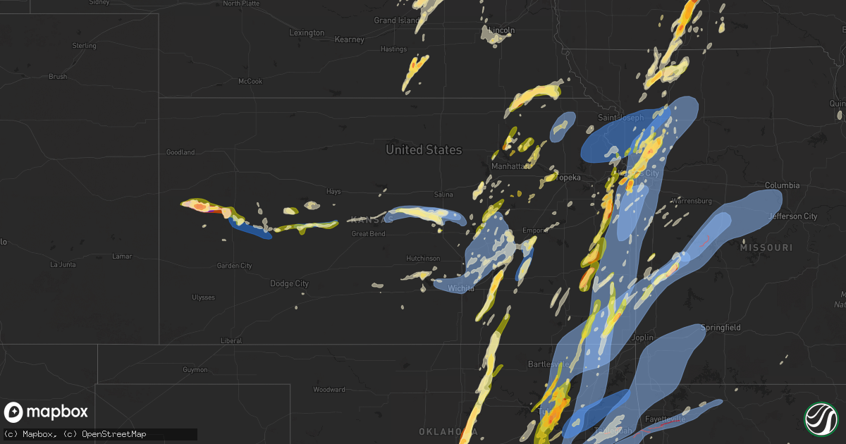
Hail Map in Kansas on May 19, 2025
Get this storm
May 19 map
$229
one time, instant access
Download today. No call, no setup
Keep the $229
Bought the map and want the full workflow? Apply the entire $229 to a subscription within 7 days. None of it is wasted.
Every map, not just this one
This buys you this map. Subscription and you get every map we run, in the markets you choose from a few cities to whole states to nationwide. Plus real-time alerts the moment a storm fires.
Contact data
Name, contact info, occupancy, even credit band for addresses in the footprint. You go from where it hit to who to call.
Become the source they trust
Unlimited branding weather history reports on demand. You already have the documented answer ready for the property owner, and you are the one who showed up with it.
Property data and RoofTrace estimates
Pull up any address you have got, its value and the exact code rules for that jurisdiction, straight from One Click Code. Then RoofTrace estimates the squares, pitch, and roof value, priced the way you price.
Storm reports in Kansas
Kansas
| Date | Description |
|---|---|
| 05/19/20256:45 PM CDT | Report was from kksdight22 observation station. |
| 05/19/20256:42 PM CDT | Delayed report. Brief tornado touched down... Crossing k4 before quickly dissipating. Tree damage was noted north of a residential property. The tornado was rated an ef |
| 05/19/20256:42 PM CDT | Delayed report. Time estimated radar. A few trees down in the road at highway k4 and north pole road. |
| 05/19/20256:41 PM CDT | A local report indicates 58 MPH wind near 2 NNW Powhattan |
| 05/19/20256:41 PM CDT | A local report indicates 1.25 inch wind near 4 S Willard |
| 05/19/20256:40 PM CDT | Estimated 50-60 mph along with dime size hail. |
| 05/19/20256:18 PM CDT | Reports of power poles down across railroad tracks... Limbs down... And power lines down across town. |
| 05/19/20256:07 PM CDT | Tree partially blocking the road. |
| 05/19/20256:04 PM CDT | Tree split in half the entire way down. Wind speed unknown. Time based on radar. |
| 05/19/20256:03 PM CDT | At least 60 mph winds. |
| 05/19/20256:00 PM CDT | Large tree on roadway. Time based on radar. |
| 05/19/20256:00 PM CDT | Multiple trees and lines down in pittsburg. Time based on radar. |
| 05/19/20255:57 PM CDT | A local report indicates 1.00 inch wind near 3 E Herington |
| 05/19/20255:54 PM CDT | Report was from the ellis feeders observation station. |
| 05/19/20255:48 PM CDT | Ohio and walnut in columbus tree on a house and truck. Multiple lines down and trees down in town. |
| 05/19/20255:43 PM CDT | A local report indicates 1.00 inch wind near Lost Springs |
| 05/19/20255:32 PM CDT | Multiple trees and power lines down in parsons. |
| 05/19/20255:31 PM CDT | A local report indicates 1.00 inch wind near 3 W Onaga |
| 05/19/20255:19 PM CDT | Tree down over the road. |
| 05/19/20255:13 PM CDT | Trees and powerlines down. Time estimated from radar. |
| 05/19/20255:08 PM CDT | Powerlines and multiple tree limbs down across the city. Possible structure fire from downed power line. Time estimated from radar. |
| 05/19/20255:08 PM CDT | A local report indicates 69 MPH wind near Coffeyville Airport |
| 05/19/20255:07 PM CDT | Time estimated from radar. |
| 05/19/20255:06 PM CDT | Emergency manager relayed a report of hail up to ping pong ball in size. |
| 05/19/20255:06 PM CDT | A local report indicates 1.50 inch wind near 2 W Olsburg |
| 05/19/20255:03 PM CDT | Large tree limbs down near downtown. Courtesy of kggf radio. |
| 05/19/20255:01 PM CDT | Estimated 65 to 70 mph wind gusts. Three-inch diameter tree limbs downed. |
| 05/19/20254:58 PM CDT | Semi blown over on highway 166. Courtesy of kggw radio. |
| 05/19/20254:51 PM CDT | A local report indicates 1.50 inch wind near Summerfield |
| 05/19/20254:42 PM CDT | Sheriff reported golf ball 689 |
| 05/19/20254:42 PM CDT | Sheriff reported golf ball to tennis ball sized hail along hwy 25. |
| 05/19/20254:40 PM CDT | Just east of girard. Tim. (sgf |
| 05/19/20254:40 PM CDT | Just east of girard. Tim. |
| 05/19/20254:35 PM CDT | Several social media reports and photos of trees and limbs down in shawnee. Time estimated from social media report. |
| 05/19/20254:34 PM CDT | Large tree snapped at olathe community center. Time roughly estimated. |
| 05/19/20254:34 PM CDT | Lane blocked by downed tree south of 135th and mur-len road. |
| 05/19/20254:34 PM CDT | Large tree down due to thunderstorm wind gusts. |
| 05/19/20254:33 PM CDT | Large tree down on house with significant damage. Time roughly estimated. |
| 05/19/20254:30 PM CDT | Downed wires near 24th street. Time estimated from radar. |
| 05/19/20254:27 PM CDT | Downed wires near hagemann street. Time estimated from radar. |
| 05/19/20254:26 PM CDT | Asos station kojc olathe executive. |
| 05/19/20254:25 PM CDT | Downed trees at a residence near everett avenue. Time estimated from radar. |
| 05/19/20254:23 PM CDT | Social media photo of a tree snapped at a residence in prairie village. Time estimated from radar. |
| 05/19/20254:23 PM CDT | Downed trees and wires near 87th street. Time estimated from dispatch report and radar. |
| 05/19/20254:20 PM CDT | Tree snapped. |
| 05/19/20254:19 PM CDT | Transformers blown out in olathe. |
| 05/19/20254:19 PM CDT | Time estimated from radar. |
| 05/19/20254:17 PM CDT | Large tree limbs snapped... Fences and stop signs blown over. |
| 05/19/20254:17 PM CDT | Multiple reports of downed trees with some on houses or property in the overland park area. Time estimated from radar. |
| 05/19/20254:17 PM CDT | Multiple reports of downed trees in the lenexa area. Time estimated from radar. |
| 05/19/20254:16 PM CDT | Ojc asos. |
| 05/19/20254:15 PM CDT | Several reports of hail quarter to half dollar size in the leavenworth area. Time estimated from social media reports. |
| 05/19/20254:12 PM CDT | Downed wires and power outages near 232nd street. Time estimated from radar. |
| 05/19/20254:12 PM CDT | Downed tree near the high school in stilwell. Time estimated from radar. |
| 05/19/20254:12 PM CDT | Several social media posts and photos of trees down in the olathe area. Time estimated from radar. |
| 05/19/20254:10 PM CDT | Private weather sensor. |
| 05/19/20254:08 PM CDT | Downed tree limbs reported on logan street. Time estimated from radar. |
| 05/19/20254:05 PM CDT | A local report indicates 65 MPH wind near 3 SSE Wagstaff |
| 05/19/20254:04 PM CDT | Downed wires and power outages near somerset road. Time estimated from radar. |
| 05/19/20254:04 PM CDT | A local report indicates 65 MPH wind near Louisburg |
| 05/19/20254:03 PM CDT | A local report indicates 1.00 inch wind near 1 W Merriam |
| 05/19/20254:03 PM CDT | Social media report. Time estimated from radar. |
| 05/19/20254:01 PM CDT | Several reports |
| 05/19/20254:00 PM CDT | Along k68... Between 169 and 69 highway there was a semi truck blown over. |
| 05/19/20253:58 PM CDT | Report from mping: quarter |
| 05/19/20253:58 PM CDT | Downed tree limbs and wires near 359th street. Time estimated from radar. |
| 05/19/20253:58 PM CDT | Social media report. Time estimated from radar. |
| 05/19/20253:54 PM CDT | Social media report. Time estimated from radar. |
| 05/19/20253:54 PM CDT | Report from mping: quarter |
| 05/19/20253:53 PM CDT | Em relayed a spotter reported measured wind gust to 63 mph. |
| 05/19/20253:52 PM CDT | A local report indicates 1.00 inch wind near Basehor |
| 05/19/20253:52 PM CDT | A local report indicates 1.75 inch wind near 1 S Lenexa |
| 05/19/20253:50 PM CDT | A local report indicates 1.75 inch wind near 2 WNW Lenexa |
| 05/19/20253:49 PM CDT | Dot relayed picture of hail to around quarter size. |
| 05/19/20253:49 PM CDT | Report from mping: quarter |
| 05/19/20253:48 PM CDT | A local report indicates 1.25 inch wind near 2 E Lenexa |
| 05/19/20253:48 PM CDT | A local report indicates 1.25 inch wind near 2 E Lenexa |
| 05/19/20253:45 PM CDT | Downed wires near 2300 road. Time estimated from radar. |
| 05/19/20253:42 PM CDT | A local report indicates 65 MPH wind near 3 N Pleasanton |
| 05/19/20253:40 PM CDT | A local report indicates 1.75 inch wind near Edgerton |
| 05/19/20253:38 PM CDT | Quarter size hail at grade school in riley. |
| 05/19/20253:36 PM CDT | At riley county grade school. |
| 05/19/20253:20 PM CDT | Power outages reported by heartland rural electric coop. |
| 05/19/20253:12 PM CDT | A local report indicates 1.00 inch wind near Garnett |
| 05/19/20253:03 PM CDT | A local report indicates 1.00 inch wind near Lone Elm |
| 05/19/20253:01 PM CDT | Off duty ff reporting 60 mph winds 5 mi nne of mccune. |
| 05/19/20253:00 PM CDT | Reports of mul ks 3911 9466 downed wires near 24th street. Time estimated from radar. |
| 05/19/20253:00 PM CDT | Reports of multiple large trees down in crawford county... Near mccune and walnut. Time based on radar. |
| 05/19/20252:59 PM CDT | A local report indicates 1.00 inch wind near La Harpe |
| 05/19/20252:58 PM CDT | A local report indicates 1.25 inch wind near Gas |
| 05/19/20252:50 PM CDT | Reports of multiple large trees down in crawford county... Near mccune and walnut. Time based on radar. |
| 05/19/20252:50 PM CDT | Power outages reported in northern cherokee county by heartland rural electric coop. |
| 05/19/20252:50 PM CDT | Power outages reported in crawford county county by heartland rural electric coop. |
| 05/19/20252:48 PM CDT | Multiple large trees down over nw belleview rd and nw 110th in cherokee county. Time based on radar estimate. |
| 05/19/20252:46 PM CDT | A local report indicates 1.00 inch wind near 2 E Humboldt |
| 05/19/202512:40 AM CDT | Delayed report... Time estimated from radar. Sporadic damage throughout the county... With trees and tree limbs downed... Along with privacy fences. Metal roof partiall |
| 05/19/202512:05 AM CDT | Delayed report... Time estimated from radar. Eight inch diameter tree limbs downed... And a lean-to was knocked down. Some of this wind damage could also have occurred |
| 05/18/202511:56 PM CDT | Awos station kewk newton city county airpt. |
| 05/18/202511:54 PM CDT | Awos station kaao 2 ese bel aire. |
| 05/18/202511:50 PM CDT | Delayed report. A handful of trees... Tree limbs... And powerlines down across the city. Some of this damage could also have occurred from strong winds well after the t |
| 05/18/202511:49 PM CDT | Report from mping: half dollar |
| 05/18/202511:40 PM CDT | Large tree fell on a house. |
| 05/18/202511:40 PM CDT | Delayed report... Received via social media from personal weather station. |
| 05/18/202511:39 PM CDT | Tree fell on house causing damage. |
| 05/18/202511:37 PM CDT | A local report indicates 75 MPH wind near 1 WSW Bridgeport |
| 05/18/202511:35 PM CDT | Delayed report. |
| 05/18/202511:33 PM CDT | A local report indicates 60 MPH wind near 3 NW Wichita Eisenhower |
| 05/18/202511:25 PM CDT | Asos station kict wichita eisenhower airport. |
| 05/18/202511:04 PM CDT | A local report indicates 1.00 inch wind near 13 WNW Marquette |
| 05/18/202511:04 PM CDT | A local report indicates 1.00 inch wind near 1 ENE Chapman |
| 05/18/202511:04 PM CDT | Hai |
| 05/18/202511:04 PM CDT | Hail covering the road. |
| 05/18/202510:51 PM CDT | A local report indicates 1.25 inch wind near 1 S Chapman |
| 05/18/202510:50 PM CDT | A local report indicates 1.25 inch wind near 1 S Chapman |
| 05/18/202510:35 PM CDT | Delayed report. This is the 10 meter wind gust... The 2 meter gust was 76 mph. Courtesy of ksu mesonet. Several tree limbs were downed per the nws coop observer in the |
| 05/18/202510:20 PM CDT | Kansas state mesonet - lorraine. |
| 05/18/20258:29 PM CDT | A local report indicates 60 MPH wind near 3 E Jarbalo |
| 05/18/20258:09 PM CDT | Estimated winds up to 60 mph. |
| 05/18/20258:06 PM CDT | A local report indicates 1.50 inch wind near 5 E El Dorado |
| 05/18/20257:57 PM CDT | A local report indicates 1.50 inch wind near 4 S El Dorado |
| 05/18/20257:55 PM CDT | Delayed report of hail based on pics from em. |
| 05/18/20257:53 PM CDT | 3 inch diameter limbs down in leon. |
| 05/18/20257:52 PM CDT | Delayed report of quarter sized hail. |
| 05/18/20257:52 PM CDT | Several reports of downed wires and power outages in the atchison area. Time estimated from radar. |
| 05/18/20257:49 PM CDT | A local report indicates 1.00 inch wind near 3 ESE Augusta |
| 05/18/20257:39 PM CDT | A local report indicates 1.00 inch wind near Ransom |
| 05/18/20257:23 PM CDT | Mesonet station cglk1 cimarron. |
All States Impacted by Hail Map on May 19, 2025
Cities Impacted by Hail Map on May 19, 2025
- Augusta, AR
- McCrory, AR
- Cotton Plant, AR
- Hunter, AR
- Palestine, AR
- Colt, AR
- Forrest City, AR
- Tishomingo, MS
- Iuka, MS
- Harrisonville, MO
- Rich Hill, MO
- Garden City, MO
- Pleasant Hill, MO
- San Saba, TX
- Butler, MO
- Burwell, NE
- Bronaugh, MO
- Holden, MO
- Kingsville, MO
- Dante, SD
- Wagner, SD
- Kempner, TX
- Ericson, NE
- Evant, TX
- Chambers, NE
- Ewing, NE
- Copperas Cove, TX
- Creighton, MO
- Bon Aqua, TN
- Dickson, TN
- Blairstown, MO
- Urich, MO
- Chilhowee, MO
- Bartlett, NE
- Moody, TX
- Niobrara, NE
- Lorena, TX
- Bruceville, TX
- McGregor, TX
- Waco, TX
- Hewitt, TX
- Gainesville, TX
- Marietta, OK
- Thackerville, OK
- Muenster, TX
- Clearwater, NE
- Orchard, NE
- Verdigre, NE
- Mill Creek, OK
- Mannsville, OK
- Olivet, SD
- Tishomingo, OK
- Madill, OK
- Lesterville, SD
- Scotland, SD
- Menno, SD
- Coleman, OK
- Wapanucka, OK
- Milburn, OK
- Caddo, OK
- Durant, OK
- Stonewall, OK
- Tupelo, OK
- Allen, OK
- Centrahoma, OK
- Rush Springs, OK
- Caney, OK
- Atoka, OK
- Irene, SD
- Volin, SD
- Mission Hill, SD
- Freeman, SD
- Lane, OK
- Calvin, OK
- Stringtown, OK
- Antlers, OK
- Stuart, OK
- Blanchard, OK
- Bradley, OK
- Coalgate, OK
- Lindsay, OK
- Moyers, OK
- Clayton, OK
- Viborg, SD
- Purcell, OK
- Hurley, SD
- Wakonda, SD
- Lexington, OK
- Noble, OK
- Norman, OK
- Newalla, OK
- Tecumseh, OK
- Canistota, SD
- Arlington, SD
- Snow, OK
- Lamar, OK
- Mcalester, OK
- Mcloud, OK
- Foster, OK
- Elmore City, OK
- Shawnee, OK
- Pauls Valley, OK
- Oklahoma City, OK
- Duncan, OK
- Davis, SD
- Chancellor, SD
- Parker, SD
- Centerville, SD
- Henryetta, OK
- Hanna, OK
- Eufaula, OK
- Weleetka, OK
- Atwood, OK
- Holdenville, OK
- Dustin, OK
- Wetumka, OK
- Okmulgee, OK
- Checotah, OK
- Council Hill, OK
- Morris, OK
- Boynton, OK
- Paoli, OK
- Haskell, OK
- Lennox, SD
- Hartford, SD
- Wayne, OK
- Porter, OK
- Byars, OK
- Wanette, OK
- Coweta, OK
- Olney, TX
- Holliday, TX
- Tremonton, UT
- Wendover, UT
- Salt Lake City, UT
- Tooele, UT
- Tea, SD
- Herriman, UT
- South Jordan, UT
- Grantsville, UT
- Bountiful, UT
- Sioux Falls, SD
- Woods Cross, UT
- North Salt Lake, UT
- Draper, UT
- Riverton, UT
- Kaysville, UT
- Redbird, OK
- Broken Arrow, OK
- Wagoner, OK
- Chouteau, OK
- Inola, OK
- Brigham City, UT
- Trent, SD
- Layton, UT
- Magna, UT
- Tulsa, OK
- West Jordan, UT
- Dell Rapids, SD
- Bixby, OK
- Farmington, UT
- Bingham Canyon, UT
- Yankton, SD
- Ogden, UT
- Sandy, UT
- Pryor, OK
- Claremore, OK
- Windthorst, TX
- Crooks, SD
- Owasso, OK
- Oologah, OK
- Collinsville, OK
- Flandreau, SD
- Catoosa, OK
- Springer, OK
- Ardmore, OK
- Strang, OK
- Spavinaw, OK
- Salina, OK
- Adair, OK
- Chelsea, OK
- Davis, OK
- Talala, OK
- Nowata, OK
- Scotland, TX
- Edgerton, MN
- Pipestone, MN
- Stockton, UT
- Locust Grove, OK
- Sulphur, OK
- Dougherty, OK
- Henrietta, TX
- Park Valley, UT
- Roff, OK
- Primrose, NE
- Cedar Rapids, NE
- Delaware, OK
- Provo, UT
- Palmer, NE
- Archer, NE
- Lenapah, OK
- Wichita Falls, TX
- Midvale, UT
- Holland, MN
- Woodstock, MN
- Big Cabin, OK
- Albion, NE
- Bluejacket, OK
- Welch, OK
- Vinita, OK
- Edna, KS
- Miami, OK
- Chetopa, KS
- Bartlett, KS
- Afton, OK
- Central City, NE
- Fullerton, NE
- Ada, OK
- Elk City, KS
- Willard, UT
- S Coffeyville, OK
- Coffeyville, KS
- Fitzhugh, OK
- Morgan, UT
- Mound Valley, KS
- Altamont, KS
- Snowville, UT
- Ringgold, TX
- Bellevue, TX
- Genoa, NE
- Chanute, KS
- Erie, KS
- Humboldt, KS
- Iola, KS
- La Harpe, KS
- Parsons, KS
- Oswego, KS
- Columbus, KS
- Fredonia, KS
- Kansas City, MO
- Stratford, OK
- Altoona, KS
- Neodesha, KS
- Dennis, KS
- Osborn, MO
- Plattsburg, MO
- Thayer, KS
- Liberty, KS
- Darlington, MO
- King City, MO
- Independence, KS
- Honeyville, UT
- McCune, KS
- Konawa, OK
- Galesburg, KS
- Saint Paul, KS
- Colony, KS
- Sasakwa, OK
- Albany, MO
- Platte City, MO
- Giltner, NE
- Aurora, NE
- Girard, KS
- Turney, MO
- Lathrop, MO
- Nocona, TX
- Ryan, OK
- Terral, OK
- Benedict, KS
- Buffalo, KS
- Smithville, MO
- Cameron, MO
- Maysville, MO
- Riverside, MO
- Edgerton, MO
- Trimble, MO
- Mercer, MO
- Asher, OK
- Weatherby, MO
- Holt, MO
- Clarks, NE
- Kansas City, KS
- Fittstown, OK
- Walnut, KS
- Uniontown, KS
- Hepler, KS
- Savonburg, KS
- Stark, KS
- Scammon, KS
- West Mineral, KS
- Pittsburg, KS
- Cherokee, KS
- Elsmore, KS
- Farlington, KS
- Arcadia, KS
- Arma, KS
- Garland, KS
- Fort Scott, KS
- Kincaid, KS
- Moran, KS
- Welda, KS
- Garnett, KS
- Martinsville, MO
- New Hampton, MO
- Bethany, MO
- Marquette, NE
- Ottawa, KS
- Saint Libory, NE
- Lineville, IA
- Gower, MO
- Jacksboro, TX
- Bryson, TX
- Okemah, OK
- Ridgeway, MO
- Paragould, AR
- Greeley, KS
- Seminole, OK
- Maud, OK
- Cope, SC
- Winston, MO
- Stewartsville, MO
- Liberty, MO
- Guide Rock, NE
- Clio, IA
- Wewoka, OK
- Kearney, MO
- Superior, NE
- Lawrence, NE
- Hampton, NE
- Hordville, NE
- Bowlegs, OK
- Newman Grove, NE
- Branchville, SC
- Corydon, IA
- Overbrook, OK
- Lone Grove, OK
- Rantoul, KS
- Princeton, KS
- Richmond, KS
- Lane, KS
- Bristow, OK
- Mapleton, KS
- Fulton, KS
- Altamont, MO
- Ringling, OK
- Osawatomie, KS
- Burneyville, OK
- Lamoni, IA
- Kellerton, IA
- Eagleville, MO
- Hatfield, MO
- Wellsville, KS
- Reevesville, SC
- Bowman, SC
- Centerville, KS
- Redfield, KS
- Bronson, KS
- Blue Mound, KS
- Deerfield, MO
- Parker, KS
- Mound City, KS
- Richards, MO
- Prescott, KS
- Hume, MO
- Pleasanton, KS
- Foster, MO
- Cainsville, MO
- Nelson, NE
- Polk, NE
- Bradshaw, NE
- Saint George, SC
- Silver Creek, NE
- Monroe, NE
- Wilson, OK
- Beggs, OK
- Mounds, OK
- Sapulpa, OK
- Kellyville, OK
- Whitesboro, TX
- Lebanon, OK
- De Soto, KS
- Lenexa, KS
- Stromsburg, NE
- Pattonsburg, MO
- Overland Park, KS
- Olathe, KS
- Chariton, IA
- Amity, MO
- Union Star, MO
- Edgerton, KS
- Paola, KS
- Milford, KS
- Bowie, TX
- Sand Springs, OK
- Eudora, KS
- Gardner, KS
- Grand River, IA
- Van Wert, IA
- Stilwell, KS
- Gallatin, MO
- McFall, MO
- Decatur, IA
- Baldwin City, KS
- Prague, OK
- Paden, OK
- Lawson, MO
- Marlow, OK
- Sharon Springs, KS
- Wallace, KS
- Healdton, OK
- Tribune, KS
- Kingston, OK
- Glenpool, OK
- Jenks, OK
- Kiefer, OK
- Shawnee, KS
- Junction City, KS
- Riley, KS
- Linwood, KS
- Osceola, NE
- Deweese, NE
- Mission, KS
- Stanberry, MO
- Basehor, KS
- Leavenworth, KS
- La Cygne, KS
- Boley, OK
- Osceola, IA
- Castle, OK
- Polo, MO
- Spring Hill, KS
- Williamson, IA
- Mannford, OK
- Bonner Springs, KS
- Edgar, NE
- Eads, CO
- Promise City, IA
- Blythedale, MO
- Denver, MO
- Prairie Village, KS
- Leawood, KS
- Ninnekah, OK
- Alex, OK
- Leonardville, KS
- Chickasha, OK
- Skiatook, OK
- Sperry, OK
- Duncan, NE
- Columbus, NE
- Oktaha, OK
- Muskogee, OK
- Gentry, MO
- Artesian, SD
- Fairfield, NE
- Montague, TX
- Sheridan Lake, CO
- Russell, IA
- Knoxville, IA
- New Virginia, IA
- Weldon, IA
- Letcher, SD
- Excelsior Springs, MO
- Millerton, IA
- Lansing, KS
- Louisburg, KS
- Kidder, MO
- Hamilton, MO
- Marysville, KS
- Tonganoxie, KS
- Kingston, MO
- Platte Center, NE
- Humphrey, NE
- Amber, OK
- Saint Jo, TX
- Shelby, NE
- Bellwood, NE
- New Century, KS
- Fontana, KS
- Amsterdam, MO
- Amoret, MO
- Adrian, MO
- Drexel, MO
- Cleveland, MO
- Bucyrus, KS
- Peculiar, MO
- Freeman, MO
- Archie, MO
- Belton, MO
- Raymore, MO
- Lees Summit, MO
- Grandview, MO
- Greenwood, MO
- Ramona, OK
- Bartlesville, OK
- Home, KS
- Prole, IA
- Cumming, IA
- Sutton, NE
- Clay Center, NE
- Norwalk, IA
- Indianola, IA
- Washington, OK
- Oketo, KS
- Winona, KS
- Leoti, KS
- Redding, IA
- Grant City, MO
- Fort Riley, KS
- Campbell, MO
- Malden, MO
- Murray, IA
- Vera, OK
- Mindenmines, MO
- Ochelata, OK
- Leon, OK
- Braggs, OK
- Hulbert, OK
- Fort Gibson, OK
- Dewey, OK
- Beattie, KS
- Burchard, NE
- Summerfield, KS
- Newcastle, OK
- Geneva, NE
- Mount Ayr, IA
- Diagonal, IA
- Franklin, KS
- Ellston, IA
- Woodburn, IA
- Rising City, NE
- Des Moines, IA
- Liberal, MO
- Barnsdall, OK
- Lamar, MO
- West Des Moines, IA
- Manhattan, KS
- Laclede, MO
- Linneus, MO
- Liberty, NE
- Independence, MO
- Blue Springs, MO
- Missouri City, MO
- Orrick, MO
- Grain Valley, MO
- Sibley, MO
- Buckner, MO
- Sheldon, MO
- Nevada, MO
- Moundville, MO
- Rayville, MO
- Cowgill, MO
- Breckenridge, MO
- Braymer, MO
- Schuyler, NE
- Howells, NE
- Clarkson, NE
- Peru, IA
- Bondurant, IA
- Elkhart, IA
- Leigh, NE
- Creston, NE
- Clive, IA
- Afton, IA
- Cambridge, IA
- Maxwell, IA
- Shannon City, IA
- Tingley, IA
- Council Grove, KS
- Saronville, NE
- Choctaw, OK
- Tahlequah, OK
- Truro, IA
- Olsburg, KS
- Saint Charles, IA
- Mulberry, KS
- Orangeburg, SC
- Park Hill, OK
- Proctor, OK
- Kansas, OK
- Rose, OK
- Peggs, OK
- Welling, OK
- Twin Oaks, OK
- Stilwell, OK
- Oaks, OK
- Wamego, KS
- Belvue, KS
- Onaga, KS
- Wann, OK
- Copan, OK
- Cherryvale, KS
- Dearing, KS
- Caney, KS
- Edmond, OK
- Jones, OK
- Arcadia, OK
- Westmoreland, KS
- Nevada, IA
- Milo, MO
- Pawnee City, NE
- Alma, KS
- Axtell, KS
- Bevington, IA
- Colo, IA
- Lucas, IA
- Guthrie, OK
- Luther, OK
- Meridian, OK
- Ankeny, IA
- El Dorado Springs, MO
- Walker, MO
- Rogers, NE
- Zearing, IA
- Collins, IA
- McCallsburg, IA
- New Providence, IA
- State Center, IA
- Hubbard, IA
- Saint Anthony, IA
- Clemons, IA
- Scott City, KS
- Westville, OK
- Colcord, OK
- Summers, AR
- Watts, OK
- Maysville, AR
- Gravette, AR
- Jay, OK
- Noel, MO
- South West City, MO
- Sulphur Springs, AR
- Gentry, AR
- Leon, IA
- David City, NE
- Eskridge, KS
- Allen, KS
- Alta Vista, KS
- Saint George, KS
- Dodge, NE
- Coyle, OK
- Perkins, OK
- Frankfort, KS
- North Bend, NE
- Siloam Springs, AR
- Decatur, AR
- Goodman, MO
- Tiff City, MO
- Anderson, MO
- Grove, OK
- Neosho, MO
- Seneca, MO
- Wyandotte, OK
- Eldora, IA
- Iowa Falls, IA
- Steamboat Rock, IA
- Ackley, IA
- Union, IA
- Harwood, MO
- Mooresville, MO
- Ludlow, MO
- Chillicothe, MO
- Lock Springs, MO
- Jamesport, MO
- Trenton, MO
- Jameson, MO
- Stillwater, OK
- Humboldt, NE
- Baileyville, KS
- Du Bois, NE
- Scribner, NE
- Carney, OK
- Wellston, OK
- Seward, NE
- Lincolnville, KS
- Avon, SD
- Dorrance, KS
- Wardville, OK
- Table Rock, NE
- Oran, MO
- Havensville, KS
- Lost Springs, KS
- Herington, KS
- Burdick, KS
- Schell City, MO
- Pittsburg, OK
- Blanco, OK
- Hartshorne, OK
- Hooper, NE
- Lanagan, MO
- Pineville, MO
- Diamond, MO
- Joplin, MO
- Granby, MO
- Stella, MO
- Pea Ridge, AR
- Bella Vista, AR
- Centerton, AR
- Bentonville, AR
- Rocky Comfort, MO
- Powell, MO
- Rogers, AR
- Hiwasse, AR
- Corning, KS
- Bee, NE
- Garland, NE
- Dwight, NE
- Clarksville, TN
- Palmyra, TN
- Bruno, NE
- Milford, NE
- Pleasant Dale, NE
- Kiowa, OK
- Savanna, OK
- Ashland City, TN
- Chapmansboro, TN
- White City, KS
- Chaffee, MO
- Madison, KS
- Linwood, NE
- Brainard, NE
- Glencoe, OK
- Goff, KS
- Soldier, KS
- Dumont, IA
- Aplington, IA
- Wilburton, OK
- Geneva, IA
- Fairview, MO
- Stark City, MO
- Sarcoxie, MO
- Pierce City, MO
- Carthage, MO
- Washburn, MO
- Seligman, MO
- Reeds, MO
- Garfield, AR
- Wheaton, MO
- Monett, MO
- Exeter, MO
- Wentworth, MO
- Purdy, MO
- Healy, KS
- Frontenac, KS
- Weir, KS
- Baxter Springs, KS
- Dawson, NE
- Asbury, MO
- Galena, KS
- Treece, KS
- Picher, OK
- Riverton, KS
- Opolis, KS
- Oronogo, MO
- Quapaw, OK
- North Miami, OK
- Carl Junction, MO
- Commerce, OK
- Agency, MO
- Red Rock, OK
- Delmont, SD
- Morrison, OK
- Crete, NE
- Olpe, KS
- Abie, NE
- Haileyville, OK
- Cambridge, KS
- Marion, KS
- Hillsboro, KS
- Wellsburg, IA
- Adams, TN
- Ames, NE
- Emporia, KS
- Perry, OK
- Lorimor, IA
- Rockville, MO
- Latham, KS
- Prague, NE
- Webbers Falls, OK
- Gore, OK
- Chico, TX
- Winslow, NE
- Porum, OK
- Warner, OK
- Pawnee, OK
- Vian, OK
- Ralston, OK
- Eucha, OK
- Ponca City, OK
- Marland, OK
- Burbank, OK
- Verona, MO
- Cassville, MO
- Butterfield, MO
- Mount Vernon, MO
- Freistatt, MO
- Stotts City, MO
- Piedmont, KS
- Cedar Hill, TN
- Denton, NE
- Lincoln, NE
- Morse Bluff, NE
- Fremont, NE
- Dearborn, MO
- Weston, MO
- La Russell, MO
- Wetmore, KS
- Emmett, KS
- Circleville, KS
- Cedar Bluffs, NE
- Eureka, KS
- Daisy, OK
- Tuskahoma, OK
- Maple Hill, KS
- Allison, IA
- Clarksville, IA
- Parkersburg, IA
- Marienthal, KS
- Greene, IA
- Wilsey, KS
- Sunset, TX
- Appleton City, MO
- Osceola, MO
- Craig, NE
- Herman, NE
- Sallisaw, OK
- Cookson, OK
- Topeka, KS
- Talihina, OK
- Red Oak, OK
- Wister, OK
- Silver Lake, KS
- Peabody, KS
- Walton, KS
- Gove, KS
- Dighton, KS
- Martell, NE
- Charles City, IA
- Netawaka, KS
- Sabetha, KS
- Dwight, KS
- Whitewater, KS
- Newton, KS
- Marble Rock, IA
- Stella, NE
- Verdon, NE
- Paxico, KS
- Saint Marys, KS
- Springfield, TN
- Nickerson, NE
- Arlington, NE
- Powhattan, KS
- Weston, NE
- Valparaiso, NE
- Kaw City, OK
- Newkirk, OK
- Fairfax, OK
- Bunch, OK
- Everton, MO
- Ash Grove, MO
- Miller, MO
- Aurora, MO
- Republic, MO
- Billings, MO
- Bois D Arc, MO
- Marionville, MO
- Springfield, MO
- Halltown, MO
- Deepwater, MO
- Lowry City, MO
- Collins, MO
- Floyd, IA
- Orchard, IA
- Riceville, IA
- Chester, IA
- Wesley, IA
- Mccurtain, OK
- Malmo, NE
- Frost, MN
- Alta Vista, IA
- Ionia, IA
- Whiting, KS
- Hamilton, KS
- Roca, NE
- Hallam, NE
- Osage, IA
- Elma, IA
- Elbing, KS
- Blair, NE
- Horton, KS
- Fairview, KS
- Forestburg, TX
- Tekamah, NE
- Maple City, KS
- Arkansas City, KS
- Matfield Green, KS
- Bokoshe, OK
- Lincoln, AR
- Canehill, AR
- Evansville, AR
- Dexter, KS
- Clinton, MO
- Warsaw, MO
- Wheatland, MO
- Quincy, MO
- Blue Earth, MN
- Easton, MN
- Minnesota Lake, MN
- Farmington, MN
- Hampton, MN
- Le Roy, MN
- Shady Point, OK
- Utica, KS
- McFarland, KS
- Prairie Grove, AR
- Ostrander, MN
- Spring Valley, MN
- Wykoff, MN
- Fountain, MN
- Mondamin, IA
- Arnold, KS
- Beeler, KS
- Burns, KS
- Holton, KS
- Shubert, NE
- Falls City, NE
- Winfield, KS
- Kenefic, OK
- Cedar Point, KS
- Lime Springs, IA
- Rossville, KS
- Osage City, KS
- Udall, KS
- Alvord, TX
- Oxford, KS
- Rock, KS
- Prue, OK
- Cameron, OK
- Spiro, OK
- Worth, MO
- Hastings, MN
- Hiawatha, KS
- Brixey, MO
- Burden, KS
- Poteau, OK
- Elmdale, KS
- Strong City, KS
- Fayetteville, AR
- Walton, NE
- Bennet, NE
- Morrow, AR
- Farmington, AR
- West Fork, AR
- Elkins, AR
- Eagle, NE
- Pocola, OK
- Hackett, AR
- Fort Smith, AR
- Arkoma, OK
- Lincoln, MO
- Windsor, MO
- Green Ridge, MO
- Calhoun, MO
- Ionia, MO
- Sedalia, MO
- Mora, MO
- Stover, MO
- Edwards, MO
- Cole Camp, MO
- Little Sioux, IA
- Modale, IA
- Dora, MO
- Ransom, KS
- Douglass, KS
- Augusta, KS
- Everest, KS
- Lancaster, KS
- Muldrow, OK
- Ness City, KS
- Ellis, KS
- Decatur, TX
- Preston, MN
- Cottonwood Falls, KS
- Rosston, TX
- Lindsay, TX
- Hindsville, AR
- Wesley, AR
- Huntsville, AR
- Barling, AR
- Lavaca, AR
- Pisgah, IA
- Van Buren, AR
- Atlanta, KS
- Leon, KS
- El Dorado, KS
- Smithton, MO
- Barnett, MO
- Versailles, MO
- Florence, MO
- Gravois Mills, MO
- Nashoba, OK
- Brownell, KS
- Benton, KS
- Valley Center, KS
- Denton, KS
- Towanda, KS
- Roland, OK
- Chatfield, MN
- Auburn, KS
- Gordonville, TX
- Alma, AR
- Fortuna, MO
- Syracuse, MO
- Otterville, MO
- Tipton, MO
- Russellville, MO
- California, MO
- Latham, MO
- Bunceton, MO
- Clarksburg, MO
- Pilot Grove, MO
- Potwin, KS
- Greenwood, AR
- Minneola, KS
- Andover, KS
- Bennington, OK
- Bazine, KS
- Alexander, KS
- Jamestown, MO
- Hartsburg, MO
- Prairie Home, MO
- Centertown, MO
- Boonville, MO
- Wooldridge, MO
- Columbia, MO
- Ashland, MO
- Howe, TX
- Sherman, TX
- Easton, KS
- Fenton, MO
- Arnold, MO
- Imperial, MO
- Valliant, OK
- Cassoday, KS
- Dyer, AR
- Mulberry, AR
- Sadler, TX
- Denison, TX
- Pottsboro, TX
- Green Forest, AR
- Alpena, AR
- Berryville, AR
- Harrison, AR
- La Crosse, KS
- Nekoma, KS
- Rush Center, KS
- Valley Falls, KS
- Oskaloosa, KS
- Ozawkie, KS
- Cummings, KS
- Rushville, MO
- Atchison, KS
- Winchester, KS
- Nortonville, KS
- Effingham, KS
- Troy, KS
- Wathena, KS
- Saint Joseph, MO
- Camden Point, MO
- Faucett, MO
- Farley, MO
- De Kalb, MO
- McLouth, KS
- Fort Leavenworth, KS
- Easton, MO
- Albion, OK
- Ringold, OK
- Saint Louis, MO
- Ozark, AR
- Broken Bow, OK
- Boswell, OK
- Heavener, OK
- McCracken, KS
- Telephone, TX
- Ivanhoe, TX
- Honobia, OK
- Charleston, AR
- Rattan, OK
- Lawrence, KS
- High Ridge, MO
- Lead Hill, AR
- Potosi, MO
- Colbert, OK
- Cartwright, OK
- Muse, OK
- Maryland Heights, MO
- Saint Ann, MO
- Bridgeton, MO
- Hazelwood, MO
- Florissant, MO
- Bison, KS
- Saint Charles, MO
- Ford, KS
- Belleview, MO
- Chesterfield, MO
- Belgrade, MO
- Howe, OK
- Fort Towson, OK
- Hendrix, OK
- Mead, OK
- Calera, OK
- Caledonia, MO
- Cosby, MO
- Clarksdale, MO
- Hartman, AR
- Neosho Rapids, KS
- Magazine, AR
- Altus, AR
- Coal Hill, AR
- Bethel, OK
- Clarksville, AR
- Hartford, AR
- Hays, KS
- Schoenchen, KS
- Bokchito, OK
- Festus, MO
- Jerseyville, IL
- Godfrey, IL
- Brighton, IL
- Booneville, AR
- Dow, IL
- Hoisington, KS
- Otis, KS
- Smithville, OK
- West Alton, MO
- Portage Des Sioux, MO
- Hodgen, OK
- Elsah, IL
- Rufe, OK
- Pratt, KS
- Paris, AR
- Garden Grove, IA
- Davisville, MO
- Palmyra, MO
- Hannibal, MO
- Olmitz, KS
- Iuka, KS
- Bells, TX
- Turon, KS
- Watson, OK
- Bonham, TX
- Ravenna, TX
- Derby, IA
- Mena, AR
- Cove, AR
- Hatfield, AR
- Zenda, KS
- Claflin, KS
- Savoy, TX
- Hope, KS
- Enterprise, KS
- Abilene, KS
- Richwoods, MO
- Dittmer, MO
- Chapman, KS
- Steelville, MO
- Holyrood, KS
- Spivey, KS
- Boles, AR
- Ellsworth, KS
- Lorraine, KS
- Arlington, KS
- Dupo, IL
- East Saint Louis, IL
- Murdock, KS
- Kingman, KS
- Pretty Prairie, KS
- Valley Park, MO
- Ballwin, MO
- Parks, AR
- Bushton, KS
- Kanopolis, KS
- Geneseo, KS
- Marquette, KS
- Hutchinson, KS
- Tampa, KS
- Partridge, KS
- Woodbine, KS
- Shirley, AR
- Clinton, AR
- Wildwood, MO
- Honey Grove, TX
- Haven, KS
- Mount Hope, KS
- Mountain View, AR
- Burrton, KS
- Andale, KS
- Eureka, MO
- Colwich, KS
- Garden Plain, KS
- Cheney, KS
- Goddard, KS
- Wichita, KS
- Maize, KS
- Mcconnell Afb, KS
- Lindsborg, KS
- Weatherford, TX
- Edgemont, AR
- Brookville, KS
- Falun, KS
- Assaria, KS
- Mcpherson, KS
- Azle, TX
- Sawyer, OK
- Langley, AR
- Glenwood, AR
- Kechi, KS
- Greenwich, KS
- Florence, KS
- Gypsum, KS
- Galva, KS
- Roxbury, KS
- Fort Worth, TX
- Caddo Gap, AR
- Durham, KS
- Canton, KS
- Naval Air Station Jrb, TX
- Norman, AR
- Moundridge, KS
- Indianola, OK
- Haltom City, TX
- Hurst, TX
- North Richland Hills, TX
- Bedford, TX
- Euless, TX
- Colleyville, TX
- Grapevine, TX
- Irving, TX
- Dallas, TX
- Coppell, TX
- Arlington, TX
- Addison, TX
- Grand Prairie, TX
- Carrollton, TX
- Plano, TX
- Richardson, TX
- Garland, TX
- Wylie, TX
- Sachse, TX
- Rowlett, TX
- Finley, OK
- Spencerville, OK
- Ogden, KS
- Royse City, TX
- Anna, IL
- Whitesboro, OK
- Rockwall, TX
- Eldorado, IL
- Reading, KS
- Lebo, KS
- Blossom, TX
- Mesquite, TX
- Lavon, TX
- Hugo, OK
- Soper, OK
- Arthur City, TX
- Grant, OK
- Lyndon, KS
- Scranton, KS
- Overbrook, KS
- Seneca, KS
- Garvin, OK
- Idabel, OK
- Mount Pleasant, TX
- Scroggins, TX
- Mount Vernon, TX
- Pittsburg, TX
- Arkadelphia, AR
- Donaldson, AR
- Fancy Farm, KY
- Clinton, KY
- Arlington, KY
- Bardwell, KY
- Malvern, AR
- Prattsville, AR
- Melber, KY
- Hickory, KY
- Mayfield, KY
- Cunningham, KY
- Sheridan, AR
- Boaz, KY
- Atlanta, TX
- Grapevine, AR
- Carthage, AR
- Bearden, AR
- Columbia, IA
- Winterset, IA
- Martensdale, IA
- Austinville, IA
- Shell Rock, IA
- Benton, IA


