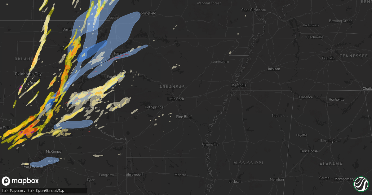
Hail Map in Arkansas on May 19, 2025
Get this storm
May 19 map
$229
one time, instant access
Download today. No call, no setup
Keep the $229
Bought the map and want the full workflow? Apply the entire $229 to a subscription within 7 days. None of it is wasted.
Every map, not just this one
This buys you this map. Subscription and you get every map we run, in the markets you choose from a few cities to whole states to nationwide. Plus real-time alerts the moment a storm fires.
Contact data
Name, contact info, occupancy, even credit band for addresses in the footprint. You go from where it hit to who to call.
Become the source they trust
Unlimited branding weather history reports on demand. You already have the documented answer ready for the property owner, and you are the one who showed up with it.
Property data and RoofTrace estimates
Pull up any address you have got, its value and the exact code rules for that jurisdiction, straight from One Click Code. Then RoofTrace estimates the squares, pitch, and roof value, priced the way you price.
Storm reports in Arkansas
Arkansas
| Date | Description |
|---|---|
| 05/19/20254:12 AM CDT | Tree limbs blown down. |
| 05/19/20254:12 AM CDT | Tree |
| 05/19/20252:50 AM CDT | Multiple trees down and power outages north of danville. |
| 05/19/20252:50 AM CDT | Multiple trees down and power outages north o |
| 05/18/202511:30 PM CDT | Multiple roads are blocked due to trees and power lines down around the county. One boat dock on greers ferry lake was flipped. |
| 05/18/202511:30 PM CDT | Trees and utility lines are down with a few homes damaged in bismarck. Trees were also reported down across hwy 128 near caney. |
| 05/18/202511:20 PM CDT | Trees down near goat ranch road. |
| 05/18/202511:00 PM CDT | A large tree down near greers ferry just past the narrows bridge. |
| 05/18/202511:00 PM CDT | Trees down across the county. Multiple roads were closed due to trees. There were power outages. A few homes suffered damage. |
| 05/18/202510:40 PM CDT | Large trees uprooted and downed trees across clinton and throughout the county. |
| 05/18/202510:15 PM CDT | Large tree limb down on west ash street in pottsville... Ar. |
| 05/18/20259:27 PM CDT | 60 mph winds reported via ham radio operator to county em in the vicinity of paris... Ar. |
| 05/18/20257:57 PM CDT | A local report indicates 1.00 inch wind near 1 NW Barling |
| 05/18/20257:50 PM CDT | A local report indicates 1.00 inch wind near Bonanza |
| 05/18/20257:31 PM CDT | Tornado debris signature. |
| 05/18/20257:22 PM CDT | Tornado debris signature. |
| 05/18/20257:20 PM CDT | Tornado debris signature. |
All States Impacted by Hail Map on May 19, 2025
Cities Impacted by Hail Map on May 19, 2025
- Augusta, AR
- McCrory, AR
- Cotton Plant, AR
- Hunter, AR
- Palestine, AR
- Colt, AR
- Forrest City, AR
- Tishomingo, MS
- Iuka, MS
- Harrisonville, MO
- Rich Hill, MO
- Garden City, MO
- Pleasant Hill, MO
- San Saba, TX
- Butler, MO
- Burwell, NE
- Bronaugh, MO
- Holden, MO
- Kingsville, MO
- Dante, SD
- Wagner, SD
- Kempner, TX
- Ericson, NE
- Evant, TX
- Chambers, NE
- Ewing, NE
- Copperas Cove, TX
- Creighton, MO
- Bon Aqua, TN
- Dickson, TN
- Blairstown, MO
- Urich, MO
- Chilhowee, MO
- Bartlett, NE
- Moody, TX
- Niobrara, NE
- Lorena, TX
- Bruceville, TX
- McGregor, TX
- Waco, TX
- Hewitt, TX
- Gainesville, TX
- Marietta, OK
- Thackerville, OK
- Muenster, TX
- Clearwater, NE
- Orchard, NE
- Verdigre, NE
- Mill Creek, OK
- Mannsville, OK
- Olivet, SD
- Tishomingo, OK
- Madill, OK
- Lesterville, SD
- Scotland, SD
- Menno, SD
- Coleman, OK
- Wapanucka, OK
- Milburn, OK
- Caddo, OK
- Durant, OK
- Stonewall, OK
- Tupelo, OK
- Allen, OK
- Centrahoma, OK
- Rush Springs, OK
- Caney, OK
- Atoka, OK
- Irene, SD
- Volin, SD
- Mission Hill, SD
- Freeman, SD
- Lane, OK
- Calvin, OK
- Stringtown, OK
- Antlers, OK
- Stuart, OK
- Blanchard, OK
- Bradley, OK
- Coalgate, OK
- Lindsay, OK
- Moyers, OK
- Clayton, OK
- Viborg, SD
- Purcell, OK
- Hurley, SD
- Wakonda, SD
- Lexington, OK
- Noble, OK
- Norman, OK
- Newalla, OK
- Tecumseh, OK
- Canistota, SD
- Arlington, SD
- Snow, OK
- Lamar, OK
- Mcalester, OK
- Mcloud, OK
- Foster, OK
- Elmore City, OK
- Shawnee, OK
- Pauls Valley, OK
- Oklahoma City, OK
- Duncan, OK
- Davis, SD
- Chancellor, SD
- Parker, SD
- Centerville, SD
- Henryetta, OK
- Hanna, OK
- Eufaula, OK
- Weleetka, OK
- Atwood, OK
- Holdenville, OK
- Dustin, OK
- Wetumka, OK
- Okmulgee, OK
- Checotah, OK
- Council Hill, OK
- Morris, OK
- Boynton, OK
- Paoli, OK
- Haskell, OK
- Lennox, SD
- Hartford, SD
- Wayne, OK
- Porter, OK
- Byars, OK
- Wanette, OK
- Coweta, OK
- Olney, TX
- Holliday, TX
- Tremonton, UT
- Wendover, UT
- Salt Lake City, UT
- Tooele, UT
- Tea, SD
- Herriman, UT
- South Jordan, UT
- Grantsville, UT
- Bountiful, UT
- Sioux Falls, SD
- Woods Cross, UT
- North Salt Lake, UT
- Draper, UT
- Riverton, UT
- Kaysville, UT
- Redbird, OK
- Broken Arrow, OK
- Wagoner, OK
- Chouteau, OK
- Inola, OK
- Brigham City, UT
- Trent, SD
- Layton, UT
- Magna, UT
- Tulsa, OK
- West Jordan, UT
- Dell Rapids, SD
- Bixby, OK
- Farmington, UT
- Bingham Canyon, UT
- Yankton, SD
- Ogden, UT
- Sandy, UT
- Pryor, OK
- Claremore, OK
- Windthorst, TX
- Crooks, SD
- Owasso, OK
- Oologah, OK
- Collinsville, OK
- Flandreau, SD
- Catoosa, OK
- Springer, OK
- Ardmore, OK
- Strang, OK
- Spavinaw, OK
- Salina, OK
- Adair, OK
- Chelsea, OK
- Davis, OK
- Talala, OK
- Nowata, OK
- Scotland, TX
- Edgerton, MN
- Pipestone, MN
- Stockton, UT
- Locust Grove, OK
- Sulphur, OK
- Dougherty, OK
- Henrietta, TX
- Park Valley, UT
- Roff, OK
- Primrose, NE
- Cedar Rapids, NE
- Delaware, OK
- Provo, UT
- Palmer, NE
- Archer, NE
- Lenapah, OK
- Wichita Falls, TX
- Midvale, UT
- Holland, MN
- Woodstock, MN
- Big Cabin, OK
- Albion, NE
- Bluejacket, OK
- Welch, OK
- Vinita, OK
- Edna, KS
- Miami, OK
- Chetopa, KS
- Bartlett, KS
- Afton, OK
- Central City, NE
- Fullerton, NE
- Ada, OK
- Elk City, KS
- Willard, UT
- S Coffeyville, OK
- Coffeyville, KS
- Fitzhugh, OK
- Morgan, UT
- Mound Valley, KS
- Altamont, KS
- Snowville, UT
- Ringgold, TX
- Bellevue, TX
- Genoa, NE
- Chanute, KS
- Erie, KS
- Humboldt, KS
- Iola, KS
- La Harpe, KS
- Parsons, KS
- Oswego, KS
- Columbus, KS
- Fredonia, KS
- Kansas City, MO
- Stratford, OK
- Altoona, KS
- Neodesha, KS
- Dennis, KS
- Osborn, MO
- Plattsburg, MO
- Thayer, KS
- Liberty, KS
- Darlington, MO
- King City, MO
- Independence, KS
- Honeyville, UT
- McCune, KS
- Konawa, OK
- Galesburg, KS
- Saint Paul, KS
- Colony, KS
- Sasakwa, OK
- Albany, MO
- Platte City, MO
- Giltner, NE
- Aurora, NE
- Girard, KS
- Turney, MO
- Lathrop, MO
- Nocona, TX
- Ryan, OK
- Terral, OK
- Benedict, KS
- Buffalo, KS
- Smithville, MO
- Cameron, MO
- Maysville, MO
- Riverside, MO
- Edgerton, MO
- Trimble, MO
- Mercer, MO
- Asher, OK
- Weatherby, MO
- Holt, MO
- Clarks, NE
- Kansas City, KS
- Fittstown, OK
- Walnut, KS
- Uniontown, KS
- Hepler, KS
- Savonburg, KS
- Stark, KS
- Scammon, KS
- West Mineral, KS
- Pittsburg, KS
- Cherokee, KS
- Elsmore, KS
- Farlington, KS
- Arcadia, KS
- Arma, KS
- Garland, KS
- Fort Scott, KS
- Kincaid, KS
- Moran, KS
- Welda, KS
- Garnett, KS
- Martinsville, MO
- New Hampton, MO
- Bethany, MO
- Marquette, NE
- Ottawa, KS
- Saint Libory, NE
- Lineville, IA
- Gower, MO
- Jacksboro, TX
- Bryson, TX
- Okemah, OK
- Ridgeway, MO
- Paragould, AR
- Greeley, KS
- Seminole, OK
- Maud, OK
- Cope, SC
- Winston, MO
- Stewartsville, MO
- Liberty, MO
- Guide Rock, NE
- Clio, IA
- Wewoka, OK
- Kearney, MO
- Superior, NE
- Lawrence, NE
- Hampton, NE
- Hordville, NE
- Bowlegs, OK
- Newman Grove, NE
- Branchville, SC
- Corydon, IA
- Overbrook, OK
- Lone Grove, OK
- Rantoul, KS
- Princeton, KS
- Richmond, KS
- Lane, KS
- Bristow, OK
- Mapleton, KS
- Fulton, KS
- Altamont, MO
- Ringling, OK
- Osawatomie, KS
- Burneyville, OK
- Lamoni, IA
- Kellerton, IA
- Eagleville, MO
- Hatfield, MO
- Wellsville, KS
- Reevesville, SC
- Bowman, SC
- Centerville, KS
- Redfield, KS
- Bronson, KS
- Blue Mound, KS
- Deerfield, MO
- Parker, KS
- Mound City, KS
- Richards, MO
- Prescott, KS
- Hume, MO
- Pleasanton, KS
- Foster, MO
- Cainsville, MO
- Nelson, NE
- Polk, NE
- Bradshaw, NE
- Saint George, SC
- Silver Creek, NE
- Monroe, NE
- Wilson, OK
- Beggs, OK
- Mounds, OK
- Sapulpa, OK
- Kellyville, OK
- Whitesboro, TX
- Lebanon, OK
- De Soto, KS
- Lenexa, KS
- Stromsburg, NE
- Pattonsburg, MO
- Overland Park, KS
- Olathe, KS
- Chariton, IA
- Amity, MO
- Union Star, MO
- Edgerton, KS
- Paola, KS
- Milford, KS
- Bowie, TX
- Sand Springs, OK
- Eudora, KS
- Gardner, KS
- Grand River, IA
- Van Wert, IA
- Stilwell, KS
- Gallatin, MO
- McFall, MO
- Decatur, IA
- Baldwin City, KS
- Prague, OK
- Paden, OK
- Lawson, MO
- Marlow, OK
- Sharon Springs, KS
- Wallace, KS
- Healdton, OK
- Tribune, KS
- Kingston, OK
- Glenpool, OK
- Jenks, OK
- Kiefer, OK
- Shawnee, KS
- Junction City, KS
- Riley, KS
- Linwood, KS
- Osceola, NE
- Deweese, NE
- Mission, KS
- Stanberry, MO
- Basehor, KS
- Leavenworth, KS
- La Cygne, KS
- Boley, OK
- Osceola, IA
- Castle, OK
- Polo, MO
- Spring Hill, KS
- Williamson, IA
- Mannford, OK
- Bonner Springs, KS
- Edgar, NE
- Eads, CO
- Promise City, IA
- Blythedale, MO
- Denver, MO
- Prairie Village, KS
- Leawood, KS
- Ninnekah, OK
- Alex, OK
- Leonardville, KS
- Chickasha, OK
- Skiatook, OK
- Sperry, OK
- Duncan, NE
- Columbus, NE
- Oktaha, OK
- Muskogee, OK
- Gentry, MO
- Artesian, SD
- Fairfield, NE
- Montague, TX
- Sheridan Lake, CO
- Russell, IA
- Knoxville, IA
- New Virginia, IA
- Weldon, IA
- Letcher, SD
- Excelsior Springs, MO
- Millerton, IA
- Lansing, KS
- Louisburg, KS
- Kidder, MO
- Hamilton, MO
- Marysville, KS
- Tonganoxie, KS
- Kingston, MO
- Platte Center, NE
- Humphrey, NE
- Amber, OK
- Saint Jo, TX
- Shelby, NE
- Bellwood, NE
- New Century, KS
- Fontana, KS
- Amsterdam, MO
- Amoret, MO
- Adrian, MO
- Drexel, MO
- Cleveland, MO
- Bucyrus, KS
- Peculiar, MO
- Freeman, MO
- Archie, MO
- Belton, MO
- Raymore, MO
- Lees Summit, MO
- Grandview, MO
- Greenwood, MO
- Ramona, OK
- Bartlesville, OK
- Home, KS
- Prole, IA
- Cumming, IA
- Sutton, NE
- Clay Center, NE
- Norwalk, IA
- Indianola, IA
- Washington, OK
- Oketo, KS
- Winona, KS
- Leoti, KS
- Redding, IA
- Grant City, MO
- Fort Riley, KS
- Campbell, MO
- Malden, MO
- Murray, IA
- Vera, OK
- Mindenmines, MO
- Ochelata, OK
- Leon, OK
- Braggs, OK
- Hulbert, OK
- Fort Gibson, OK
- Dewey, OK
- Beattie, KS
- Burchard, NE
- Summerfield, KS
- Newcastle, OK
- Geneva, NE
- Mount Ayr, IA
- Diagonal, IA
- Franklin, KS
- Ellston, IA
- Woodburn, IA
- Rising City, NE
- Des Moines, IA
- Liberal, MO
- Barnsdall, OK
- Lamar, MO
- West Des Moines, IA
- Manhattan, KS
- Laclede, MO
- Linneus, MO
- Liberty, NE
- Independence, MO
- Blue Springs, MO
- Missouri City, MO
- Orrick, MO
- Grain Valley, MO
- Sibley, MO
- Buckner, MO
- Sheldon, MO
- Nevada, MO
- Moundville, MO
- Rayville, MO
- Cowgill, MO
- Breckenridge, MO
- Braymer, MO
- Schuyler, NE
- Howells, NE
- Clarkson, NE
- Peru, IA
- Bondurant, IA
- Elkhart, IA
- Leigh, NE
- Creston, NE
- Clive, IA
- Afton, IA
- Cambridge, IA
- Maxwell, IA
- Shannon City, IA
- Tingley, IA
- Council Grove, KS
- Saronville, NE
- Choctaw, OK
- Tahlequah, OK
- Truro, IA
- Olsburg, KS
- Saint Charles, IA
- Mulberry, KS
- Orangeburg, SC
- Park Hill, OK
- Proctor, OK
- Kansas, OK
- Rose, OK
- Peggs, OK
- Welling, OK
- Twin Oaks, OK
- Stilwell, OK
- Oaks, OK
- Wamego, KS
- Belvue, KS
- Onaga, KS
- Wann, OK
- Copan, OK
- Cherryvale, KS
- Dearing, KS
- Caney, KS
- Edmond, OK
- Jones, OK
- Arcadia, OK
- Westmoreland, KS
- Nevada, IA
- Milo, MO
- Pawnee City, NE
- Alma, KS
- Axtell, KS
- Bevington, IA
- Colo, IA
- Lucas, IA
- Guthrie, OK
- Luther, OK
- Meridian, OK
- Ankeny, IA
- El Dorado Springs, MO
- Walker, MO
- Rogers, NE
- Zearing, IA
- Collins, IA
- McCallsburg, IA
- New Providence, IA
- State Center, IA
- Hubbard, IA
- Saint Anthony, IA
- Clemons, IA
- Scott City, KS
- Westville, OK
- Colcord, OK
- Summers, AR
- Watts, OK
- Maysville, AR
- Gravette, AR
- Jay, OK
- Noel, MO
- South West City, MO
- Sulphur Springs, AR
- Gentry, AR
- Leon, IA
- David City, NE
- Eskridge, KS
- Allen, KS
- Alta Vista, KS
- Saint George, KS
- Dodge, NE
- Coyle, OK
- Perkins, OK
- Frankfort, KS
- North Bend, NE
- Siloam Springs, AR
- Decatur, AR
- Goodman, MO
- Tiff City, MO
- Anderson, MO
- Grove, OK
- Neosho, MO
- Seneca, MO
- Wyandotte, OK
- Eldora, IA
- Iowa Falls, IA
- Steamboat Rock, IA
- Ackley, IA
- Union, IA
- Harwood, MO
- Mooresville, MO
- Ludlow, MO
- Chillicothe, MO
- Lock Springs, MO
- Jamesport, MO
- Trenton, MO
- Jameson, MO
- Stillwater, OK
- Humboldt, NE
- Baileyville, KS
- Du Bois, NE
- Scribner, NE
- Carney, OK
- Wellston, OK
- Seward, NE
- Lincolnville, KS
- Avon, SD
- Dorrance, KS
- Wardville, OK
- Table Rock, NE
- Oran, MO
- Havensville, KS
- Lost Springs, KS
- Herington, KS
- Burdick, KS
- Schell City, MO
- Pittsburg, OK
- Blanco, OK
- Hartshorne, OK
- Hooper, NE
- Lanagan, MO
- Pineville, MO
- Diamond, MO
- Joplin, MO
- Granby, MO
- Stella, MO
- Pea Ridge, AR
- Bella Vista, AR
- Centerton, AR
- Bentonville, AR
- Rocky Comfort, MO
- Powell, MO
- Rogers, AR
- Hiwasse, AR
- Corning, KS
- Bee, NE
- Garland, NE
- Dwight, NE
- Clarksville, TN
- Palmyra, TN
- Bruno, NE
- Milford, NE
- Pleasant Dale, NE
- Kiowa, OK
- Savanna, OK
- Ashland City, TN
- Chapmansboro, TN
- White City, KS
- Chaffee, MO
- Madison, KS
- Linwood, NE
- Brainard, NE
- Glencoe, OK
- Goff, KS
- Soldier, KS
- Dumont, IA
- Aplington, IA
- Wilburton, OK
- Geneva, IA
- Fairview, MO
- Stark City, MO
- Sarcoxie, MO
- Pierce City, MO
- Carthage, MO
- Washburn, MO
- Seligman, MO
- Reeds, MO
- Garfield, AR
- Wheaton, MO
- Monett, MO
- Exeter, MO
- Wentworth, MO
- Purdy, MO
- Healy, KS
- Frontenac, KS
- Weir, KS
- Baxter Springs, KS
- Dawson, NE
- Asbury, MO
- Galena, KS
- Treece, KS
- Picher, OK
- Riverton, KS
- Opolis, KS
- Oronogo, MO
- Quapaw, OK
- North Miami, OK
- Carl Junction, MO
- Commerce, OK
- Agency, MO
- Red Rock, OK
- Delmont, SD
- Morrison, OK
- Crete, NE
- Olpe, KS
- Abie, NE
- Haileyville, OK
- Cambridge, KS
- Marion, KS
- Hillsboro, KS
- Wellsburg, IA
- Adams, TN
- Ames, NE
- Emporia, KS
- Perry, OK
- Lorimor, IA
- Rockville, MO
- Latham, KS
- Prague, NE
- Webbers Falls, OK
- Gore, OK
- Chico, TX
- Winslow, NE
- Porum, OK
- Warner, OK
- Pawnee, OK
- Vian, OK
- Ralston, OK
- Eucha, OK
- Ponca City, OK
- Marland, OK
- Burbank, OK
- Verona, MO
- Cassville, MO
- Butterfield, MO
- Mount Vernon, MO
- Freistatt, MO
- Stotts City, MO
- Piedmont, KS
- Cedar Hill, TN
- Denton, NE
- Lincoln, NE
- Morse Bluff, NE
- Fremont, NE
- Dearborn, MO
- Weston, MO
- La Russell, MO
- Wetmore, KS
- Emmett, KS
- Circleville, KS
- Cedar Bluffs, NE
- Eureka, KS
- Daisy, OK
- Tuskahoma, OK
- Maple Hill, KS
- Allison, IA
- Clarksville, IA
- Parkersburg, IA
- Marienthal, KS
- Greene, IA
- Wilsey, KS
- Sunset, TX
- Appleton City, MO
- Osceola, MO
- Craig, NE
- Herman, NE
- Sallisaw, OK
- Cookson, OK
- Topeka, KS
- Talihina, OK
- Red Oak, OK
- Wister, OK
- Silver Lake, KS
- Peabody, KS
- Walton, KS
- Gove, KS
- Dighton, KS
- Martell, NE
- Charles City, IA
- Netawaka, KS
- Sabetha, KS
- Dwight, KS
- Whitewater, KS
- Newton, KS
- Marble Rock, IA
- Stella, NE
- Verdon, NE
- Paxico, KS
- Saint Marys, KS
- Springfield, TN
- Nickerson, NE
- Arlington, NE
- Powhattan, KS
- Weston, NE
- Valparaiso, NE
- Kaw City, OK
- Newkirk, OK
- Fairfax, OK
- Bunch, OK
- Everton, MO
- Ash Grove, MO
- Miller, MO
- Aurora, MO
- Republic, MO
- Billings, MO
- Bois D Arc, MO
- Marionville, MO
- Springfield, MO
- Halltown, MO
- Deepwater, MO
- Lowry City, MO
- Collins, MO
- Floyd, IA
- Orchard, IA
- Riceville, IA
- Chester, IA
- Wesley, IA
- Mccurtain, OK
- Malmo, NE
- Frost, MN
- Alta Vista, IA
- Ionia, IA
- Whiting, KS
- Hamilton, KS
- Roca, NE
- Hallam, NE
- Osage, IA
- Elma, IA
- Elbing, KS
- Blair, NE
- Horton, KS
- Fairview, KS
- Forestburg, TX
- Tekamah, NE
- Maple City, KS
- Arkansas City, KS
- Matfield Green, KS
- Bokoshe, OK
- Lincoln, AR
- Canehill, AR
- Evansville, AR
- Dexter, KS
- Clinton, MO
- Warsaw, MO
- Wheatland, MO
- Quincy, MO
- Blue Earth, MN
- Easton, MN
- Minnesota Lake, MN
- Farmington, MN
- Hampton, MN
- Le Roy, MN
- Shady Point, OK
- Utica, KS
- McFarland, KS
- Prairie Grove, AR
- Ostrander, MN
- Spring Valley, MN
- Wykoff, MN
- Fountain, MN
- Mondamin, IA
- Arnold, KS
- Beeler, KS
- Burns, KS
- Holton, KS
- Shubert, NE
- Falls City, NE
- Winfield, KS
- Kenefic, OK
- Cedar Point, KS
- Lime Springs, IA
- Rossville, KS
- Osage City, KS
- Udall, KS
- Alvord, TX
- Oxford, KS
- Rock, KS
- Prue, OK
- Cameron, OK
- Spiro, OK
- Worth, MO
- Hastings, MN
- Hiawatha, KS
- Brixey, MO
- Burden, KS
- Poteau, OK
- Elmdale, KS
- Strong City, KS
- Fayetteville, AR
- Walton, NE
- Bennet, NE
- Morrow, AR
- Farmington, AR
- West Fork, AR
- Elkins, AR
- Eagle, NE
- Pocola, OK
- Hackett, AR
- Fort Smith, AR
- Arkoma, OK
- Lincoln, MO
- Windsor, MO
- Green Ridge, MO
- Calhoun, MO
- Ionia, MO
- Sedalia, MO
- Mora, MO
- Stover, MO
- Edwards, MO
- Cole Camp, MO
- Little Sioux, IA
- Modale, IA
- Dora, MO
- Ransom, KS
- Douglass, KS
- Augusta, KS
- Everest, KS
- Lancaster, KS
- Muldrow, OK
- Ness City, KS
- Ellis, KS
- Decatur, TX
- Preston, MN
- Cottonwood Falls, KS
- Rosston, TX
- Lindsay, TX
- Hindsville, AR
- Wesley, AR
- Huntsville, AR
- Barling, AR
- Lavaca, AR
- Pisgah, IA
- Van Buren, AR
- Atlanta, KS
- Leon, KS
- El Dorado, KS
- Smithton, MO
- Barnett, MO
- Versailles, MO
- Florence, MO
- Gravois Mills, MO
- Nashoba, OK
- Brownell, KS
- Benton, KS
- Valley Center, KS
- Denton, KS
- Towanda, KS
- Roland, OK
- Chatfield, MN
- Auburn, KS
- Gordonville, TX
- Alma, AR
- Fortuna, MO
- Syracuse, MO
- Otterville, MO
- Tipton, MO
- Russellville, MO
- California, MO
- Latham, MO
- Bunceton, MO
- Clarksburg, MO
- Pilot Grove, MO
- Potwin, KS
- Greenwood, AR
- Minneola, KS
- Andover, KS
- Bennington, OK
- Bazine, KS
- Alexander, KS
- Jamestown, MO
- Hartsburg, MO
- Prairie Home, MO
- Centertown, MO
- Boonville, MO
- Wooldridge, MO
- Columbia, MO
- Ashland, MO
- Howe, TX
- Sherman, TX
- Easton, KS
- Fenton, MO
- Arnold, MO
- Imperial, MO
- Valliant, OK
- Cassoday, KS
- Dyer, AR
- Mulberry, AR
- Sadler, TX
- Denison, TX
- Pottsboro, TX
- Green Forest, AR
- Alpena, AR
- Berryville, AR
- Harrison, AR
- La Crosse, KS
- Nekoma, KS
- Rush Center, KS
- Valley Falls, KS
- Oskaloosa, KS
- Ozawkie, KS
- Cummings, KS
- Rushville, MO
- Atchison, KS
- Winchester, KS
- Nortonville, KS
- Effingham, KS
- Troy, KS
- Wathena, KS
- Saint Joseph, MO
- Camden Point, MO
- Faucett, MO
- Farley, MO
- De Kalb, MO
- McLouth, KS
- Fort Leavenworth, KS
- Easton, MO
- Albion, OK
- Ringold, OK
- Saint Louis, MO
- Ozark, AR
- Broken Bow, OK
- Boswell, OK
- Heavener, OK
- McCracken, KS
- Telephone, TX
- Ivanhoe, TX
- Honobia, OK
- Charleston, AR
- Rattan, OK
- Lawrence, KS
- High Ridge, MO
- Lead Hill, AR
- Potosi, MO
- Colbert, OK
- Cartwright, OK
- Muse, OK
- Maryland Heights, MO
- Saint Ann, MO
- Bridgeton, MO
- Hazelwood, MO
- Florissant, MO
- Bison, KS
- Saint Charles, MO
- Ford, KS
- Belleview, MO
- Chesterfield, MO
- Belgrade, MO
- Howe, OK
- Fort Towson, OK
- Hendrix, OK
- Mead, OK
- Calera, OK
- Caledonia, MO
- Cosby, MO
- Clarksdale, MO
- Hartman, AR
- Neosho Rapids, KS
- Magazine, AR
- Altus, AR
- Coal Hill, AR
- Bethel, OK
- Clarksville, AR
- Hartford, AR
- Hays, KS
- Schoenchen, KS
- Bokchito, OK
- Festus, MO
- Jerseyville, IL
- Godfrey, IL
- Brighton, IL
- Booneville, AR
- Dow, IL
- Hoisington, KS
- Otis, KS
- Smithville, OK
- West Alton, MO
- Portage Des Sioux, MO
- Hodgen, OK
- Elsah, IL
- Rufe, OK
- Pratt, KS
- Paris, AR
- Garden Grove, IA
- Davisville, MO
- Palmyra, MO
- Hannibal, MO
- Olmitz, KS
- Iuka, KS
- Bells, TX
- Turon, KS
- Watson, OK
- Bonham, TX
- Ravenna, TX
- Derby, IA
- Mena, AR
- Cove, AR
- Hatfield, AR
- Zenda, KS
- Claflin, KS
- Savoy, TX
- Hope, KS
- Enterprise, KS
- Abilene, KS
- Richwoods, MO
- Dittmer, MO
- Chapman, KS
- Steelville, MO
- Holyrood, KS
- Spivey, KS
- Boles, AR
- Ellsworth, KS
- Lorraine, KS
- Arlington, KS
- Dupo, IL
- East Saint Louis, IL
- Murdock, KS
- Kingman, KS
- Pretty Prairie, KS
- Valley Park, MO
- Ballwin, MO
- Parks, AR
- Bushton, KS
- Kanopolis, KS
- Geneseo, KS
- Marquette, KS
- Hutchinson, KS
- Tampa, KS
- Partridge, KS
- Woodbine, KS
- Shirley, AR
- Clinton, AR
- Wildwood, MO
- Honey Grove, TX
- Haven, KS
- Mount Hope, KS
- Mountain View, AR
- Burrton, KS
- Andale, KS
- Eureka, MO
- Colwich, KS
- Garden Plain, KS
- Cheney, KS
- Goddard, KS
- Wichita, KS
- Maize, KS
- Mcconnell Afb, KS
- Lindsborg, KS
- Weatherford, TX
- Edgemont, AR
- Brookville, KS
- Falun, KS
- Assaria, KS
- Mcpherson, KS
- Azle, TX
- Sawyer, OK
- Langley, AR
- Glenwood, AR
- Kechi, KS
- Greenwich, KS
- Florence, KS
- Gypsum, KS
- Galva, KS
- Roxbury, KS
- Fort Worth, TX
- Caddo Gap, AR
- Durham, KS
- Canton, KS
- Naval Air Station Jrb, TX
- Norman, AR
- Moundridge, KS
- Indianola, OK
- Haltom City, TX
- Hurst, TX
- North Richland Hills, TX
- Bedford, TX
- Euless, TX
- Colleyville, TX
- Grapevine, TX
- Irving, TX
- Dallas, TX
- Coppell, TX
- Arlington, TX
- Addison, TX
- Grand Prairie, TX
- Carrollton, TX
- Plano, TX
- Richardson, TX
- Garland, TX
- Wylie, TX
- Sachse, TX
- Rowlett, TX
- Finley, OK
- Spencerville, OK
- Ogden, KS
- Royse City, TX
- Anna, IL
- Whitesboro, OK
- Rockwall, TX
- Eldorado, IL
- Reading, KS
- Lebo, KS
- Blossom, TX
- Mesquite, TX
- Lavon, TX
- Hugo, OK
- Soper, OK
- Arthur City, TX
- Grant, OK
- Lyndon, KS
- Scranton, KS
- Overbrook, KS
- Seneca, KS
- Garvin, OK
- Idabel, OK
- Mount Pleasant, TX
- Scroggins, TX
- Mount Vernon, TX
- Pittsburg, TX
- Arkadelphia, AR
- Donaldson, AR
- Fancy Farm, KY
- Clinton, KY
- Arlington, KY
- Bardwell, KY
- Malvern, AR
- Prattsville, AR
- Melber, KY
- Hickory, KY
- Mayfield, KY
- Cunningham, KY
- Sheridan, AR
- Boaz, KY
- Atlanta, TX
- Grapevine, AR
- Carthage, AR
- Bearden, AR
- Columbia, IA
- Winterset, IA
- Martensdale, IA
- Austinville, IA
- Shell Rock, IA
- Benton, IA


