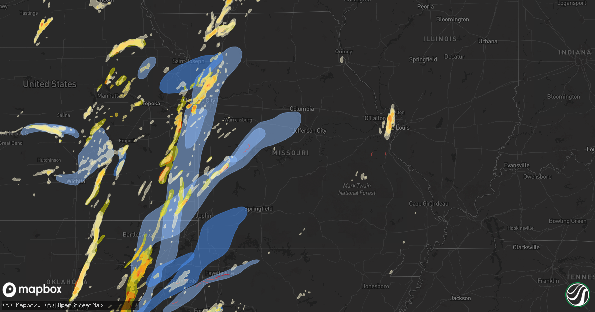
Hail Map in Missouri on May 19, 2025
Get this storm
May 19 map
$229
one time, instant access
Download today. No call, no setup
Keep the $229
Bought the map and want the full workflow? Apply the entire $229 to a subscription within 7 days. None of it is wasted.
Every map, not just this one
This buys you this map. Subscription and you get every map we run, in the markets you choose from a few cities to whole states to nationwide. Plus real-time alerts the moment a storm fires.
Contact data
Name, contact info, occupancy, even credit band for addresses in the footprint. You go from where it hit to who to call.
Become the source they trust
Unlimited branding weather history reports on demand. You already have the documented answer ready for the property owner, and you are the one who showed up with it.
Property data and RoofTrace estimates
Pull up any address you have got, its value and the exact code rules for that jurisdiction, straight from One Click Code. Then RoofTrace estimates the squares, pitch, and roof value, priced the way you price.
Storm reports in Missouri
Missouri
| Date | Description |
|---|---|
| 05/19/20256:57 PM CDT | Trees blown down. Time based on radar. Delayed report from social media. |
| 05/19/20256:55 PM CDT | Branch down on a larger tree due to wind. Delayed report from social media. |
| 05/19/20256:48 PM CDT | Road closed due to debris on roadway route u eastbound. Time based on radar. |
| 05/19/20256:45 PM CDT | Power outage in brownington... Lowry city... Deepater. Many reports of power lines down. |
| 05/19/20256:45 PM CDT | U highway and 501 south of el dorado springs. Time based on radar. Pics in slack. |
| 05/19/20256:42 PM CDT | Tree in middle of hwy zz east of law 1220 marionville in eb lane. Time based on radar. |
| 05/19/20256:40 PM CDT | El do fire is enroute to trees and power lines down 32 highway south of el dorado. Time based on radar. |
| 05/19/20256:25 PM CDT | Southbound i49 mm 79.8 tractor trailer overturned blocking one lane. Time based on radar. |
| 05/19/20256:18 PM CDT | Few limbs down by driveway... Healthy maples 8 to 10 inch diameter. Many small limbs and leaves down. |
| 05/19/20256:15 PM CDT | Joplin airport asos. |
| 05/19/20256:10 PM CDT | Large tree down. |
| 05/19/20256:07 PM CDT | Roof off a garage. |
| 05/19/20256:05 PM CDT | Garage had significant damage due to large tree that fell on it. Neighbors horses were struck by lightning. Delayed report via social media. Time based on radar. |
| 05/19/20256:00 PM CDT | Large trees down. Time based on radar. |
| 05/19/20256:00 PM CDT | Roof damage. Time based on radar. |
| 05/19/20256:00 PM CDT | Tree damage. Time based on radar. |
| 05/19/20255:41 PM CDT | 69 mph measured gust at 17:41 hours about 7 miles west southwest of goodman. |
| 05/19/20255:36 PM CDT | Downed wires and power outages in the hamilton area. Time estimated from radar. |
| 05/19/20255:30 PM CDT | Quarter sized hail on highway 54... 3 miles west of el dorado springs. Time based on radar. |
| 05/19/20255:20 PM CDT | Downed wires and power outages near route 116. Time estimated from radar. |
| 05/19/20255:16 PM CDT | Downed tree on route 131 near route ff. Time estimated from radar. |
| 05/19/20255:14 PM CDT | Social media report of downed tree on county road 465. Time estimated from radar. |
| 05/19/20255:10 PM CDT | Report from mping... Quarter 1.00 in. |
| 05/19/20255:10 PM CDT | Several social media reports of trees and limbs down in independence. Time estimated from radar. |
| 05/19/20255:05 PM CDT | Private weather sensor. |
| 05/19/20255:00 PM CDT | Downed wires and power outages near excelsior springs. Time estimated from radar. |
| 05/19/20254:58 PM CDT | Several downed trees on 188th street. Time estimated from radar. |
| 05/19/20254:53 PM CDT | Mci asos. |
| 05/19/20254:48 PM CDT | Downed tree and light pole near route 152. Time estimated from radar. |
| 05/19/20254:46 PM CDT | Social media reports and photos of trees and limbs down in independence near the stadiums. Time estimated from social media reports and confirmed from radar. |
| 05/19/20254:45 PM CDT | Large tree down at a residence. Time estimated from radar. |
| 05/19/20254:45 PM CDT | Downed tree limbs and wires in the courtney and river bend areas. Time estimated from radar. |
| 05/19/20254:43 PM CDT | Downed trees and wires near atherton road. Time estimated from radar. |
| 05/19/20254:38 PM CDT | Mkc asos. |
| 05/19/20254:38 PM CDT | Multiple trees down on houses in gladstone. Time estimated from radar. |
| 05/19/20254:38 PM CDT | Numerous 2-6 inch diameter tree branches down. As well as smaller trees in general. |
| 05/19/20254:36 PM CDT | Downed trees and power poles in the white oak area. Time estimated from radar. |
| 05/19/20254:36 PM CDT | Downed tree onto a house. Time estimated from radar. |
| 05/19/20254:35 PM CDT | Multiple trees snapped or downed near smart avenue. Time estimated from radar and social media reports. |
| 05/19/20254:35 PM CDT | Downed trees and wires near north shore drive. Time estimated from radar. |
| 05/19/20254:34 PM CDT | Downed tree limbs and wires tracy avenue. Time estimated from radar and dispatch report. |
| 05/19/20254:33 PM CDT | Tree fell on top of house. |
| 05/19/20254:31 PM CDT | Downed wires and power outages near and south of trenton. Time estimated from radar. |
| 05/19/20254:31 PM CDT | Downed tree damaged a roof on a property in lees summit. Time estimated from radar. |
| 05/19/20254:29 PM CDT | A local report indicates 65 MPH wind near 2 ENE Weatherby Lake |
| 05/19/20254:29 PM CDT | Several downed trees and limbs near holmes road. Time estimated from radar. |
| 05/19/20254:27 PM CDT | Large tree down at a residence. Time estimated from radar. |
| 05/19/20254:27 PM CDT | Downed tree limbs and wires near 57th street. Time estimated from radar. |
| 05/19/20254:27 PM CDT | Multiple reports of downed trees and wires on the south side of kansas city. Time estimated from radar. |
| 05/19/20254:23 PM CDT | Large tree down in the red bridge area. Time estimated from radar. |
| 05/19/20254:23 PM CDT | Downed wires and power outages near monroe street. Time estimated from radar. |
| 05/19/20254:23 PM CDT | Downed tree limbs and wires near mcgee street. Time estimated from radar. |
| 05/19/20254:21 PM CDT | Multiple reports of trees down with some onto vehicles or houses in the belton area. Time estimated from radar. |
| 05/19/20254:21 PM CDT | Multiple social media reports and photos of downed trees in the meadowview trailer park area. Time estimated from radar. |
| 05/19/20254:20 PM CDT | Tree downed on house. |
| 05/19/20254:20 PM CDT | Downed power line due to thunderstorm wind gusts. |
| 05/19/20254:17 PM CDT | Social media report. Time estimated from radar. |
| 05/19/20254:12 PM CDT | Social media report of a large tree down at a residence. Time estimated from radar. |
| 05/19/20254:12 PM CDT | Social media report of quarter size hail near lawson. Time estimated from radar. |
| 05/19/20254:08 PM CDT | Social media report. Time estimated from radar. |
| 05/19/20254:05 PM CDT | A local report indicates 1.25 inch wind near 1 S Kearney |
| 05/19/20254:03 PM CDT | Social media report. Time estimated from radar. |
| 05/19/20254:03 PM CDT | Social media report of two-inch hail in kearney. Time estimated from radar. |
| 05/19/20253:57 PM CDT | A local report indicates 1.00 inch wind near Kansas City |
| 05/19/20253:54 PM CDT | Report from mping: ping pong ball |
| 05/19/20253:54 PM CDT | Social media report and photo of golf ball size hail near holt. Time estimated from radar. |
| 05/19/20253:54 PM CDT | Social media report. Time estimated from radar. |
| 05/19/20253:45 PM CDT | Downed trees near route u near worland. Time estimated from radar. |
| 05/19/20253:40 PM CDT | Social media report. Time estimated from radar. |
| 05/19/20253:31 PM CDT | Multiple social media reports of quarter size hail in the bethany area. Time estimated from radar. |
| 05/19/20253:30 PM CDT | A local report indicates 2.50 inch wind near 1 NW Kearney |
| 05/19/20253:30 PM CDT | A local report indicates 1.75 inch wind near 1 N Kearney |
| 05/19/20253:21 PM CDT | Report from mping: quarter |
| 05/19/20253:21 PM CDT | Em relayed report of larger than quarter hail near bethany. |
| 05/19/20253:20 PM CDT | Time confirmed from radar. |
| 05/19/20253:20 PM CDT | Report from mping: quarter |
| 05/19/20253:17 PM CDT | Social media report of quarter size hail in cameron. Time estimated from radar. |
| 05/19/20253:17 PM CDT | Social media report of ping pong ball size hail south of hatfield. Time estimated from radar. |
| 05/19/20253:17 PM CDT | Social media report. Time estimated from radar. |
| 05/19/20253:17 PM CDT | A local report indicates 1.50 inch wind near 4 NW Liberty |
| 05/19/20253:08 PM CDT | Time estimated from radar. |
| 05/19/20253:03 PM CDT | Social media report. Time confirmed from radar. |
| 05/19/20252:59 PM CDT | Social media report. Time estimated from radar. |
| 05/19/20252:59 PM CDT | Social media report. Time estimated from radar. |
| 05/19/20252:55 PM CDT | Public reported quarter hail. |
| 05/19/20252:54 PM CDT | A local report indicates 1.75 inch wind near 1 ESE Albany |
| 05/19/20252:54 PM CDT | Social media report of quarter size hail in smithville. Time estimated from radar. |
| 05/19/20252:54 PM CDT | Social media report of hail slightly larger than golf balls east of albany. Time estimated from radar. |
| 05/19/20252:45 PM CDT | Social media report. Time estimated from radar. |
| 05/19/20258:28 AM CDT | Emergency manager reported quarter hail in rich hill. |
| 05/19/20254:03 AM CDT | Multiple social media reports of trees and limbs down in kearney. Time based on social media reports and confirmed from radar. |
| 05/19/20254:03 AM CDT | Multiple social media reports of trees and limbs down in kearney. Time b |
| 05/19/20254:03 AM CDT | Multiple social media reports of trees and limbs |
| 05/19/20254:03 AM CDT | Multiple social media reports of trees and limbs down in |
| 05/19/20254:03 AM CDT | Multiple social media reports of trees and limbs down in kear |
| 05/19/20251:05 AM CDT | Multiple trees/branches down in cape girardeau and jackson. |
| 05/19/202512:30 AM CDT | Corrects previous tstm wnd dmg report from 4 ne poplar bluff. |
| 05/19/202512:02 AM CDT | Dispatch reports tree limbs down across town. |
| 05/19/202512:02 AM CDT | Nws storm survey revealed an ef-0 tornado in far northern ste. Genevieve county. |
| 05/19/202512:02 AM CDT | Via facebook: numerous medium to large healthy trees uprooted... Snapped... And topped. |
| 05/19/202512:02 AM CDT | Via facebook: numerous medium to large... Healthy trees snapped and uprooted northwest of bloomsdale. |
| 05/18/202511:47 PM CDT | Dispatch reports trees down in farmington. |
| 05/18/202511:44 PM CDT | Dispatch reports power lines down in park hills. |
| 05/18/202511:31 PM CDT | Nws storm survey revealed an ef-1 tornado in southwestern st. Francois county. |
| 05/18/202511:31 PM CDT | Dispatch reports trees down across ironton and pilot knob. |
| 05/18/202511:29 PM CDT | Dispatch reports trees down across ironton and pilot knob. |
| 05/18/202511:10 PM CDT | Via facebook: two 12 inch tree branches snapped and fallen... Damaging soft metal fence in reporters backyard. |
| 05/18/202511:01 PM CDT | Report of tree damage near highway 100 and fountain city road. |
| 05/18/202510:46 PM CDT | Numerous large trees broken and uprooted. |
| 05/18/202510:45 PM CDT | Corrects previous tstm wnd dmg report from cuba. Dispatch reports a powerline down on the south side of cuba. |
| 05/18/202510:35 PM CDT | Tree down about 10 miles east of salem on highway 32. |
| 05/18/202510:24 PM CDT | Tree down on highway 8. Time estimated from radar. |
| 05/18/202510:20 PM CDT | Trees down 3-4 miles south of salem. |
| 05/18/202510:20 PM CDT | Trees and branches down on cr5080 and highway 19 south of salem. Time estimated by radar. |
| 05/18/202510:00 PM CDT | Two trees down on state highway 17 near gaston road intersection. Multiple power poles down as well. |
| 05/18/20259:45 PM CDT | Dispatch reports a powerline down on the south side of cuba. |
| 05/18/20259:40 PM CDT | Hail in hannibal between 1-3 cm |
| 05/18/20259:36 PM CDT | Tree down across the road. Time estimated from radar. |
| 05/18/20259:26 PM CDT | Private |
| 05/18/20259:26 PM CDT | Private weather sensor. |
| 05/18/20259:20 PM CDT | Tree down on c highway north of skyline. Time based on radar. |
| 05/18/20259:06 PM CDT | Tree down on 14 hwy. Time based on radar. |
| 05/18/20259:01 PM CDT | Observer estimated wind gusts around 40 mph. |
| 05/18/20259:00 PM CDT | Tree down. Time based on radar. |
| 05/18/20259:00 PM CDT | Tree on road. Modot on way to clear. Time based on radar. |
| 05/18/20259:00 PM CDT | A local report indicates 1.00 inch wind near Florissant |
| 05/18/20258:58 PM CDT | A local report indicates 1.50 inch wind near 1 NNE Berkeley |
| 05/18/20258:58 PM CDT | A local report indicates 1.25 inch wind near 1 NNW Hazelwood |
| 05/18/20258:57 PM CDT | A local report indicates 1.25 inch wind near 1 NW Hazelwood |
| 05/18/20258:56 PM CDT | Via slack: missouri state highway patrol reported golf ball sized hail in florissant. |
| 05/18/20258:56 PM CDT | Via facebook: 1.5 inch hail measured with ruler. |
| 05/18/20258:56 PM CDT | Multiple reports of tree limbs and wires down east of easton. Time estimated from radar. |
| 05/18/20258:56 PM CDT | Nws storm survey revealed an ef-1 tornado in far northern iron county and southern washington county. |
| 05/18/20258:56 PM CDT | Via facebook: numerous downed and damaged trees along and blocking highway dd on the washington/iron county line. Report notes that this is the case for miles along thi |
| 05/18/20258:50 PM CDT | A local report indicates 1.75 inch wind near Saint Ann |
| 05/18/20258:50 PM CDT | Via slack: a few quarter sized hailstones falling east of maryland heights. |
| 05/18/20258:49 PM CDT | Downed trees in the easton area. Time estimated from radar. |
| 05/18/20258:48 PM CDT | Several reports of downed wires and power outages between amazonia and forbes. Time estimated from radar. |
| 05/18/20258:45 PM CDT | A local report indicates 1.00 inch wind near Hazelwood |
| 05/18/20258:42 PM CDT | Tree down on swan cave. Time based on radar. |
| 05/18/20258:40 PM CDT | A local report indicates 1.75 inch wind near Kirkwood |
| 05/18/20258:38 PM CDT | Dispatch reports several trees with limbs down in rural cole county. |
| 05/18/20258:38 PM CDT | Via twitter: photo of 2 inch diameter hail with measurement included. |
| 05/18/20258:38 PM CDT | Report from mping: quarter |
| 05/18/20258:37 PM CDT | Downed wires and power outages near jefferson road. Time estimated from radar. |
| 05/18/20258:37 PM CDT | Downed tree and wires near jefferson road. Time estimated from radar. |
| 05/18/20258:36 PM CDT | Social media video of a downed tree on power lines in southeast saint joseph. Time estimated from radar. |
| 05/18/20258:36 PM CDT | Several reports of downed wires and power outages south of st. Joseph. Time estimated from radar. |
| 05/18/20258:33 PM CDT | Large tree across road. Time based on radar. Delayed report. |
| 05/18/20258:32 PM CDT | Downed wires and power outages near king hill road. Time estimated from radar. |
| 05/18/20258:32 PM CDT | Side of industrial building damaged with wall collapse. Time estimated from radar. |
| 05/18/20258:28 PM CDT | Multiple reports of downed trees and wires near katy trail state park. Time estimated from radar. |
| 05/18/20258:27 PM CDT | Downed wires near old highway 40. Time estimated from radar. |
| 05/18/20258:25 PM CDT | Tree down on hiawatha just north of riverdale... 10 in circum. Time based on radar. Delayed report. |
| 05/18/20258:18 PM CDT | Numerous trees downed. |
| 05/18/20258:14 PM CDT | Downed wires near walnut street. Time estimated from radar. |
| 05/18/20258:06 PM CDT | Multiple trees and power lines down. A house fire due to a lightning strike... And just got reports of a machine shop with heavy damage or destroyed near the house fire |
| 05/18/20257:52 PM CDT | Downed wires and power outages near muschaney road. Time estimated from radar. |
| 05/18/20257:50 PM CDT | Lost power and downed branches. Delayed report vis social media. Time based on radar. |
| 05/18/20257:50 PM CDT | Road closed due to trees. Time based on radar. |
| 05/18/20257:30 PM CDT | Near thibaut boat ramp area trees down and they witnessed what they thought was a tornado with debris aloft. |
| 05/18/20257:30 PM CDT | Tree damage in lincoln on highway 65. Time based in radar. |
| 05/18/20257:25 PM CDT | Media in the area estimated 70 to 80 mph rfd winds. |
| 05/18/20257:14 PM CDT | Social media report and photos of several trees down at a residence east of deepwater. Time estimated from radar. |
| 05/18/20257:10 PM CDT | Iconium missouri fire reporting multiple trees down along hh hwy blocking roadways in multiple places. Time based on radar. |
| 05/18/20257:00 PM CDT | 6 to 12 feet limbs down. Delayed report via social media. |
| 05/18/20257:00 PM CDT | Roof of barn blocking south bound 13 in lowry city. Also reports significant damage. Time based on radar. |
All States Impacted by Hail Map on May 19, 2025
Cities Impacted by Hail Map on May 19, 2025
- Augusta, AR
- McCrory, AR
- Cotton Plant, AR
- Hunter, AR
- Palestine, AR
- Colt, AR
- Forrest City, AR
- Tishomingo, MS
- Iuka, MS
- Harrisonville, MO
- Rich Hill, MO
- Garden City, MO
- Pleasant Hill, MO
- San Saba, TX
- Butler, MO
- Burwell, NE
- Bronaugh, MO
- Holden, MO
- Kingsville, MO
- Dante, SD
- Wagner, SD
- Kempner, TX
- Ericson, NE
- Evant, TX
- Chambers, NE
- Ewing, NE
- Copperas Cove, TX
- Creighton, MO
- Bon Aqua, TN
- Dickson, TN
- Blairstown, MO
- Urich, MO
- Chilhowee, MO
- Bartlett, NE
- Moody, TX
- Niobrara, NE
- Lorena, TX
- Bruceville, TX
- McGregor, TX
- Waco, TX
- Hewitt, TX
- Gainesville, TX
- Marietta, OK
- Thackerville, OK
- Muenster, TX
- Clearwater, NE
- Orchard, NE
- Verdigre, NE
- Mill Creek, OK
- Mannsville, OK
- Olivet, SD
- Tishomingo, OK
- Madill, OK
- Lesterville, SD
- Scotland, SD
- Menno, SD
- Coleman, OK
- Wapanucka, OK
- Milburn, OK
- Caddo, OK
- Durant, OK
- Stonewall, OK
- Tupelo, OK
- Allen, OK
- Centrahoma, OK
- Rush Springs, OK
- Caney, OK
- Atoka, OK
- Irene, SD
- Volin, SD
- Mission Hill, SD
- Freeman, SD
- Lane, OK
- Calvin, OK
- Stringtown, OK
- Antlers, OK
- Stuart, OK
- Blanchard, OK
- Bradley, OK
- Coalgate, OK
- Lindsay, OK
- Moyers, OK
- Clayton, OK
- Viborg, SD
- Purcell, OK
- Hurley, SD
- Wakonda, SD
- Lexington, OK
- Noble, OK
- Norman, OK
- Newalla, OK
- Tecumseh, OK
- Canistota, SD
- Arlington, SD
- Snow, OK
- Lamar, OK
- Mcalester, OK
- Mcloud, OK
- Foster, OK
- Elmore City, OK
- Shawnee, OK
- Pauls Valley, OK
- Oklahoma City, OK
- Duncan, OK
- Davis, SD
- Chancellor, SD
- Parker, SD
- Centerville, SD
- Henryetta, OK
- Hanna, OK
- Eufaula, OK
- Weleetka, OK
- Atwood, OK
- Holdenville, OK
- Dustin, OK
- Wetumka, OK
- Okmulgee, OK
- Checotah, OK
- Council Hill, OK
- Morris, OK
- Boynton, OK
- Paoli, OK
- Haskell, OK
- Lennox, SD
- Hartford, SD
- Wayne, OK
- Porter, OK
- Byars, OK
- Wanette, OK
- Coweta, OK
- Olney, TX
- Holliday, TX
- Tremonton, UT
- Wendover, UT
- Salt Lake City, UT
- Tooele, UT
- Tea, SD
- Herriman, UT
- South Jordan, UT
- Grantsville, UT
- Bountiful, UT
- Sioux Falls, SD
- Woods Cross, UT
- North Salt Lake, UT
- Draper, UT
- Riverton, UT
- Kaysville, UT
- Redbird, OK
- Broken Arrow, OK
- Wagoner, OK
- Chouteau, OK
- Inola, OK
- Brigham City, UT
- Trent, SD
- Layton, UT
- Magna, UT
- Tulsa, OK
- West Jordan, UT
- Dell Rapids, SD
- Bixby, OK
- Farmington, UT
- Bingham Canyon, UT
- Yankton, SD
- Ogden, UT
- Sandy, UT
- Pryor, OK
- Claremore, OK
- Windthorst, TX
- Crooks, SD
- Owasso, OK
- Oologah, OK
- Collinsville, OK
- Flandreau, SD
- Catoosa, OK
- Springer, OK
- Ardmore, OK
- Strang, OK
- Spavinaw, OK
- Salina, OK
- Adair, OK
- Chelsea, OK
- Davis, OK
- Talala, OK
- Nowata, OK
- Scotland, TX
- Edgerton, MN
- Pipestone, MN
- Stockton, UT
- Locust Grove, OK
- Sulphur, OK
- Dougherty, OK
- Henrietta, TX
- Park Valley, UT
- Roff, OK
- Primrose, NE
- Cedar Rapids, NE
- Delaware, OK
- Provo, UT
- Palmer, NE
- Archer, NE
- Lenapah, OK
- Wichita Falls, TX
- Midvale, UT
- Holland, MN
- Woodstock, MN
- Big Cabin, OK
- Albion, NE
- Bluejacket, OK
- Welch, OK
- Vinita, OK
- Edna, KS
- Miami, OK
- Chetopa, KS
- Bartlett, KS
- Afton, OK
- Central City, NE
- Fullerton, NE
- Ada, OK
- Elk City, KS
- Willard, UT
- S Coffeyville, OK
- Coffeyville, KS
- Fitzhugh, OK
- Morgan, UT
- Mound Valley, KS
- Altamont, KS
- Snowville, UT
- Ringgold, TX
- Bellevue, TX
- Genoa, NE
- Chanute, KS
- Erie, KS
- Humboldt, KS
- Iola, KS
- La Harpe, KS
- Parsons, KS
- Oswego, KS
- Columbus, KS
- Fredonia, KS
- Kansas City, MO
- Stratford, OK
- Altoona, KS
- Neodesha, KS
- Dennis, KS
- Osborn, MO
- Plattsburg, MO
- Thayer, KS
- Liberty, KS
- Darlington, MO
- King City, MO
- Independence, KS
- Honeyville, UT
- McCune, KS
- Konawa, OK
- Galesburg, KS
- Saint Paul, KS
- Colony, KS
- Sasakwa, OK
- Albany, MO
- Platte City, MO
- Giltner, NE
- Aurora, NE
- Girard, KS
- Turney, MO
- Lathrop, MO
- Nocona, TX
- Ryan, OK
- Terral, OK
- Benedict, KS
- Buffalo, KS
- Smithville, MO
- Cameron, MO
- Maysville, MO
- Riverside, MO
- Edgerton, MO
- Trimble, MO
- Mercer, MO
- Asher, OK
- Weatherby, MO
- Holt, MO
- Clarks, NE
- Kansas City, KS
- Fittstown, OK
- Walnut, KS
- Uniontown, KS
- Hepler, KS
- Savonburg, KS
- Stark, KS
- Scammon, KS
- West Mineral, KS
- Pittsburg, KS
- Cherokee, KS
- Elsmore, KS
- Farlington, KS
- Arcadia, KS
- Arma, KS
- Garland, KS
- Fort Scott, KS
- Kincaid, KS
- Moran, KS
- Welda, KS
- Garnett, KS
- Martinsville, MO
- New Hampton, MO
- Bethany, MO
- Marquette, NE
- Ottawa, KS
- Saint Libory, NE
- Lineville, IA
- Gower, MO
- Jacksboro, TX
- Bryson, TX
- Okemah, OK
- Ridgeway, MO
- Paragould, AR
- Greeley, KS
- Seminole, OK
- Maud, OK
- Cope, SC
- Winston, MO
- Stewartsville, MO
- Liberty, MO
- Guide Rock, NE
- Clio, IA
- Wewoka, OK
- Kearney, MO
- Superior, NE
- Lawrence, NE
- Hampton, NE
- Hordville, NE
- Bowlegs, OK
- Newman Grove, NE
- Branchville, SC
- Corydon, IA
- Overbrook, OK
- Lone Grove, OK
- Rantoul, KS
- Princeton, KS
- Richmond, KS
- Lane, KS
- Bristow, OK
- Mapleton, KS
- Fulton, KS
- Altamont, MO
- Ringling, OK
- Osawatomie, KS
- Burneyville, OK
- Lamoni, IA
- Kellerton, IA
- Eagleville, MO
- Hatfield, MO
- Wellsville, KS
- Reevesville, SC
- Bowman, SC
- Centerville, KS
- Redfield, KS
- Bronson, KS
- Blue Mound, KS
- Deerfield, MO
- Parker, KS
- Mound City, KS
- Richards, MO
- Prescott, KS
- Hume, MO
- Pleasanton, KS
- Foster, MO
- Cainsville, MO
- Nelson, NE
- Polk, NE
- Bradshaw, NE
- Saint George, SC
- Silver Creek, NE
- Monroe, NE
- Wilson, OK
- Beggs, OK
- Mounds, OK
- Sapulpa, OK
- Kellyville, OK
- Whitesboro, TX
- Lebanon, OK
- De Soto, KS
- Lenexa, KS
- Stromsburg, NE
- Pattonsburg, MO
- Overland Park, KS
- Olathe, KS
- Chariton, IA
- Amity, MO
- Union Star, MO
- Edgerton, KS
- Paola, KS
- Milford, KS
- Bowie, TX
- Sand Springs, OK
- Eudora, KS
- Gardner, KS
- Grand River, IA
- Van Wert, IA
- Stilwell, KS
- Gallatin, MO
- McFall, MO
- Decatur, IA
- Baldwin City, KS
- Prague, OK
- Paden, OK
- Lawson, MO
- Marlow, OK
- Sharon Springs, KS
- Wallace, KS
- Healdton, OK
- Tribune, KS
- Kingston, OK
- Glenpool, OK
- Jenks, OK
- Kiefer, OK
- Shawnee, KS
- Junction City, KS
- Riley, KS
- Linwood, KS
- Osceola, NE
- Deweese, NE
- Mission, KS
- Stanberry, MO
- Basehor, KS
- Leavenworth, KS
- La Cygne, KS
- Boley, OK
- Osceola, IA
- Castle, OK
- Polo, MO
- Spring Hill, KS
- Williamson, IA
- Mannford, OK
- Bonner Springs, KS
- Edgar, NE
- Eads, CO
- Promise City, IA
- Blythedale, MO
- Denver, MO
- Prairie Village, KS
- Leawood, KS
- Ninnekah, OK
- Alex, OK
- Leonardville, KS
- Chickasha, OK
- Skiatook, OK
- Sperry, OK
- Duncan, NE
- Columbus, NE
- Oktaha, OK
- Muskogee, OK
- Gentry, MO
- Artesian, SD
- Fairfield, NE
- Montague, TX
- Sheridan Lake, CO
- Russell, IA
- Knoxville, IA
- New Virginia, IA
- Weldon, IA
- Letcher, SD
- Excelsior Springs, MO
- Millerton, IA
- Lansing, KS
- Louisburg, KS
- Kidder, MO
- Hamilton, MO
- Marysville, KS
- Tonganoxie, KS
- Kingston, MO
- Platte Center, NE
- Humphrey, NE
- Amber, OK
- Saint Jo, TX
- Shelby, NE
- Bellwood, NE
- New Century, KS
- Fontana, KS
- Amsterdam, MO
- Amoret, MO
- Adrian, MO
- Drexel, MO
- Cleveland, MO
- Bucyrus, KS
- Peculiar, MO
- Freeman, MO
- Archie, MO
- Belton, MO
- Raymore, MO
- Lees Summit, MO
- Grandview, MO
- Greenwood, MO
- Ramona, OK
- Bartlesville, OK
- Home, KS
- Prole, IA
- Cumming, IA
- Sutton, NE
- Clay Center, NE
- Norwalk, IA
- Indianola, IA
- Washington, OK
- Oketo, KS
- Winona, KS
- Leoti, KS
- Redding, IA
- Grant City, MO
- Fort Riley, KS
- Campbell, MO
- Malden, MO
- Murray, IA
- Vera, OK
- Mindenmines, MO
- Ochelata, OK
- Leon, OK
- Braggs, OK
- Hulbert, OK
- Fort Gibson, OK
- Dewey, OK
- Beattie, KS
- Burchard, NE
- Summerfield, KS
- Newcastle, OK
- Geneva, NE
- Mount Ayr, IA
- Diagonal, IA
- Franklin, KS
- Ellston, IA
- Woodburn, IA
- Rising City, NE
- Des Moines, IA
- Liberal, MO
- Barnsdall, OK
- Lamar, MO
- West Des Moines, IA
- Manhattan, KS
- Laclede, MO
- Linneus, MO
- Liberty, NE
- Independence, MO
- Blue Springs, MO
- Missouri City, MO
- Orrick, MO
- Grain Valley, MO
- Sibley, MO
- Buckner, MO
- Sheldon, MO
- Nevada, MO
- Moundville, MO
- Rayville, MO
- Cowgill, MO
- Breckenridge, MO
- Braymer, MO
- Schuyler, NE
- Howells, NE
- Clarkson, NE
- Peru, IA
- Bondurant, IA
- Elkhart, IA
- Leigh, NE
- Creston, NE
- Clive, IA
- Afton, IA
- Cambridge, IA
- Maxwell, IA
- Shannon City, IA
- Tingley, IA
- Council Grove, KS
- Saronville, NE
- Choctaw, OK
- Tahlequah, OK
- Truro, IA
- Olsburg, KS
- Saint Charles, IA
- Mulberry, KS
- Orangeburg, SC
- Park Hill, OK
- Proctor, OK
- Kansas, OK
- Rose, OK
- Peggs, OK
- Welling, OK
- Twin Oaks, OK
- Stilwell, OK
- Oaks, OK
- Wamego, KS
- Belvue, KS
- Onaga, KS
- Wann, OK
- Copan, OK
- Cherryvale, KS
- Dearing, KS
- Caney, KS
- Edmond, OK
- Jones, OK
- Arcadia, OK
- Westmoreland, KS
- Nevada, IA
- Milo, MO
- Pawnee City, NE
- Alma, KS
- Axtell, KS
- Bevington, IA
- Colo, IA
- Lucas, IA
- Guthrie, OK
- Luther, OK
- Meridian, OK
- Ankeny, IA
- El Dorado Springs, MO
- Walker, MO
- Rogers, NE
- Zearing, IA
- Collins, IA
- McCallsburg, IA
- New Providence, IA
- State Center, IA
- Hubbard, IA
- Saint Anthony, IA
- Clemons, IA
- Scott City, KS
- Westville, OK
- Colcord, OK
- Summers, AR
- Watts, OK
- Maysville, AR
- Gravette, AR
- Jay, OK
- Noel, MO
- South West City, MO
- Sulphur Springs, AR
- Gentry, AR
- Leon, IA
- David City, NE
- Eskridge, KS
- Allen, KS
- Alta Vista, KS
- Saint George, KS
- Dodge, NE
- Coyle, OK
- Perkins, OK
- Frankfort, KS
- North Bend, NE
- Siloam Springs, AR
- Decatur, AR
- Goodman, MO
- Tiff City, MO
- Anderson, MO
- Grove, OK
- Neosho, MO
- Seneca, MO
- Wyandotte, OK
- Eldora, IA
- Iowa Falls, IA
- Steamboat Rock, IA
- Ackley, IA
- Union, IA
- Harwood, MO
- Mooresville, MO
- Ludlow, MO
- Chillicothe, MO
- Lock Springs, MO
- Jamesport, MO
- Trenton, MO
- Jameson, MO
- Stillwater, OK
- Humboldt, NE
- Baileyville, KS
- Du Bois, NE
- Scribner, NE
- Carney, OK
- Wellston, OK
- Seward, NE
- Lincolnville, KS
- Avon, SD
- Dorrance, KS
- Wardville, OK
- Table Rock, NE
- Oran, MO
- Havensville, KS
- Lost Springs, KS
- Herington, KS
- Burdick, KS
- Schell City, MO
- Pittsburg, OK
- Blanco, OK
- Hartshorne, OK
- Hooper, NE
- Lanagan, MO
- Pineville, MO
- Diamond, MO
- Joplin, MO
- Granby, MO
- Stella, MO
- Pea Ridge, AR
- Bella Vista, AR
- Centerton, AR
- Bentonville, AR
- Rocky Comfort, MO
- Powell, MO
- Rogers, AR
- Hiwasse, AR
- Corning, KS
- Bee, NE
- Garland, NE
- Dwight, NE
- Clarksville, TN
- Palmyra, TN
- Bruno, NE
- Milford, NE
- Pleasant Dale, NE
- Kiowa, OK
- Savanna, OK
- Ashland City, TN
- Chapmansboro, TN
- White City, KS
- Chaffee, MO
- Madison, KS
- Linwood, NE
- Brainard, NE
- Glencoe, OK
- Goff, KS
- Soldier, KS
- Dumont, IA
- Aplington, IA
- Wilburton, OK
- Geneva, IA
- Fairview, MO
- Stark City, MO
- Sarcoxie, MO
- Pierce City, MO
- Carthage, MO
- Washburn, MO
- Seligman, MO
- Reeds, MO
- Garfield, AR
- Wheaton, MO
- Monett, MO
- Exeter, MO
- Wentworth, MO
- Purdy, MO
- Healy, KS
- Frontenac, KS
- Weir, KS
- Baxter Springs, KS
- Dawson, NE
- Asbury, MO
- Galena, KS
- Treece, KS
- Picher, OK
- Riverton, KS
- Opolis, KS
- Oronogo, MO
- Quapaw, OK
- North Miami, OK
- Carl Junction, MO
- Commerce, OK
- Agency, MO
- Red Rock, OK
- Delmont, SD
- Morrison, OK
- Crete, NE
- Olpe, KS
- Abie, NE
- Haileyville, OK
- Cambridge, KS
- Marion, KS
- Hillsboro, KS
- Wellsburg, IA
- Adams, TN
- Ames, NE
- Emporia, KS
- Perry, OK
- Lorimor, IA
- Rockville, MO
- Latham, KS
- Prague, NE
- Webbers Falls, OK
- Gore, OK
- Chico, TX
- Winslow, NE
- Porum, OK
- Warner, OK
- Pawnee, OK
- Vian, OK
- Ralston, OK
- Eucha, OK
- Ponca City, OK
- Marland, OK
- Burbank, OK
- Verona, MO
- Cassville, MO
- Butterfield, MO
- Mount Vernon, MO
- Freistatt, MO
- Stotts City, MO
- Piedmont, KS
- Cedar Hill, TN
- Denton, NE
- Lincoln, NE
- Morse Bluff, NE
- Fremont, NE
- Dearborn, MO
- Weston, MO
- La Russell, MO
- Wetmore, KS
- Emmett, KS
- Circleville, KS
- Cedar Bluffs, NE
- Eureka, KS
- Daisy, OK
- Tuskahoma, OK
- Maple Hill, KS
- Allison, IA
- Clarksville, IA
- Parkersburg, IA
- Marienthal, KS
- Greene, IA
- Wilsey, KS
- Sunset, TX
- Appleton City, MO
- Osceola, MO
- Craig, NE
- Herman, NE
- Sallisaw, OK
- Cookson, OK
- Topeka, KS
- Talihina, OK
- Red Oak, OK
- Wister, OK
- Silver Lake, KS
- Peabody, KS
- Walton, KS
- Gove, KS
- Dighton, KS
- Martell, NE
- Charles City, IA
- Netawaka, KS
- Sabetha, KS
- Dwight, KS
- Whitewater, KS
- Newton, KS
- Marble Rock, IA
- Stella, NE
- Verdon, NE
- Paxico, KS
- Saint Marys, KS
- Springfield, TN
- Nickerson, NE
- Arlington, NE
- Powhattan, KS
- Weston, NE
- Valparaiso, NE
- Kaw City, OK
- Newkirk, OK
- Fairfax, OK
- Bunch, OK
- Everton, MO
- Ash Grove, MO
- Miller, MO
- Aurora, MO
- Republic, MO
- Billings, MO
- Bois D Arc, MO
- Marionville, MO
- Springfield, MO
- Halltown, MO
- Deepwater, MO
- Lowry City, MO
- Collins, MO
- Floyd, IA
- Orchard, IA
- Riceville, IA
- Chester, IA
- Wesley, IA
- Mccurtain, OK
- Malmo, NE
- Frost, MN
- Alta Vista, IA
- Ionia, IA
- Whiting, KS
- Hamilton, KS
- Roca, NE
- Hallam, NE
- Osage, IA
- Elma, IA
- Elbing, KS
- Blair, NE
- Horton, KS
- Fairview, KS
- Forestburg, TX
- Tekamah, NE
- Maple City, KS
- Arkansas City, KS
- Matfield Green, KS
- Bokoshe, OK
- Lincoln, AR
- Canehill, AR
- Evansville, AR
- Dexter, KS
- Clinton, MO
- Warsaw, MO
- Wheatland, MO
- Quincy, MO
- Blue Earth, MN
- Easton, MN
- Minnesota Lake, MN
- Farmington, MN
- Hampton, MN
- Le Roy, MN
- Shady Point, OK
- Utica, KS
- McFarland, KS
- Prairie Grove, AR
- Ostrander, MN
- Spring Valley, MN
- Wykoff, MN
- Fountain, MN
- Mondamin, IA
- Arnold, KS
- Beeler, KS
- Burns, KS
- Holton, KS
- Shubert, NE
- Falls City, NE
- Winfield, KS
- Kenefic, OK
- Cedar Point, KS
- Lime Springs, IA
- Rossville, KS
- Osage City, KS
- Udall, KS
- Alvord, TX
- Oxford, KS
- Rock, KS
- Prue, OK
- Cameron, OK
- Spiro, OK
- Worth, MO
- Hastings, MN
- Hiawatha, KS
- Brixey, MO
- Burden, KS
- Poteau, OK
- Elmdale, KS
- Strong City, KS
- Fayetteville, AR
- Walton, NE
- Bennet, NE
- Morrow, AR
- Farmington, AR
- West Fork, AR
- Elkins, AR
- Eagle, NE
- Pocola, OK
- Hackett, AR
- Fort Smith, AR
- Arkoma, OK
- Lincoln, MO
- Windsor, MO
- Green Ridge, MO
- Calhoun, MO
- Ionia, MO
- Sedalia, MO
- Mora, MO
- Stover, MO
- Edwards, MO
- Cole Camp, MO
- Little Sioux, IA
- Modale, IA
- Dora, MO
- Ransom, KS
- Douglass, KS
- Augusta, KS
- Everest, KS
- Lancaster, KS
- Muldrow, OK
- Ness City, KS
- Ellis, KS
- Decatur, TX
- Preston, MN
- Cottonwood Falls, KS
- Rosston, TX
- Lindsay, TX
- Hindsville, AR
- Wesley, AR
- Huntsville, AR
- Barling, AR
- Lavaca, AR
- Pisgah, IA
- Van Buren, AR
- Atlanta, KS
- Leon, KS
- El Dorado, KS
- Smithton, MO
- Barnett, MO
- Versailles, MO
- Florence, MO
- Gravois Mills, MO
- Nashoba, OK
- Brownell, KS
- Benton, KS
- Valley Center, KS
- Denton, KS
- Towanda, KS
- Roland, OK
- Chatfield, MN
- Auburn, KS
- Gordonville, TX
- Alma, AR
- Fortuna, MO
- Syracuse, MO
- Otterville, MO
- Tipton, MO
- Russellville, MO
- California, MO
- Latham, MO
- Bunceton, MO
- Clarksburg, MO
- Pilot Grove, MO
- Potwin, KS
- Greenwood, AR
- Minneola, KS
- Andover, KS
- Bennington, OK
- Bazine, KS
- Alexander, KS
- Jamestown, MO
- Hartsburg, MO
- Prairie Home, MO
- Centertown, MO
- Boonville, MO
- Wooldridge, MO
- Columbia, MO
- Ashland, MO
- Howe, TX
- Sherman, TX
- Easton, KS
- Fenton, MO
- Arnold, MO
- Imperial, MO
- Valliant, OK
- Cassoday, KS
- Dyer, AR
- Mulberry, AR
- Sadler, TX
- Denison, TX
- Pottsboro, TX
- Green Forest, AR
- Alpena, AR
- Berryville, AR
- Harrison, AR
- La Crosse, KS
- Nekoma, KS
- Rush Center, KS
- Valley Falls, KS
- Oskaloosa, KS
- Ozawkie, KS
- Cummings, KS
- Rushville, MO
- Atchison, KS
- Winchester, KS
- Nortonville, KS
- Effingham, KS
- Troy, KS
- Wathena, KS
- Saint Joseph, MO
- Camden Point, MO
- Faucett, MO
- Farley, MO
- De Kalb, MO
- McLouth, KS
- Fort Leavenworth, KS
- Easton, MO
- Albion, OK
- Ringold, OK
- Saint Louis, MO
- Ozark, AR
- Broken Bow, OK
- Boswell, OK
- Heavener, OK
- McCracken, KS
- Telephone, TX
- Ivanhoe, TX
- Honobia, OK
- Charleston, AR
- Rattan, OK
- Lawrence, KS
- High Ridge, MO
- Lead Hill, AR
- Potosi, MO
- Colbert, OK
- Cartwright, OK
- Muse, OK
- Maryland Heights, MO
- Saint Ann, MO
- Bridgeton, MO
- Hazelwood, MO
- Florissant, MO
- Bison, KS
- Saint Charles, MO
- Ford, KS
- Belleview, MO
- Chesterfield, MO
- Belgrade, MO
- Howe, OK
- Fort Towson, OK
- Hendrix, OK
- Mead, OK
- Calera, OK
- Caledonia, MO
- Cosby, MO
- Clarksdale, MO
- Hartman, AR
- Neosho Rapids, KS
- Magazine, AR
- Altus, AR
- Coal Hill, AR
- Bethel, OK
- Clarksville, AR
- Hartford, AR
- Hays, KS
- Schoenchen, KS
- Bokchito, OK
- Festus, MO
- Jerseyville, IL
- Godfrey, IL
- Brighton, IL
- Booneville, AR
- Dow, IL
- Hoisington, KS
- Otis, KS
- Smithville, OK
- West Alton, MO
- Portage Des Sioux, MO
- Hodgen, OK
- Elsah, IL
- Rufe, OK
- Pratt, KS
- Paris, AR
- Garden Grove, IA
- Davisville, MO
- Palmyra, MO
- Hannibal, MO
- Olmitz, KS
- Iuka, KS
- Bells, TX
- Turon, KS
- Watson, OK
- Bonham, TX
- Ravenna, TX
- Derby, IA
- Mena, AR
- Cove, AR
- Hatfield, AR
- Zenda, KS
- Claflin, KS
- Savoy, TX
- Hope, KS
- Enterprise, KS
- Abilene, KS
- Richwoods, MO
- Dittmer, MO
- Chapman, KS
- Steelville, MO
- Holyrood, KS
- Spivey, KS
- Boles, AR
- Ellsworth, KS
- Lorraine, KS
- Arlington, KS
- Dupo, IL
- East Saint Louis, IL
- Murdock, KS
- Kingman, KS
- Pretty Prairie, KS
- Valley Park, MO
- Ballwin, MO
- Parks, AR
- Bushton, KS
- Kanopolis, KS
- Geneseo, KS
- Marquette, KS
- Hutchinson, KS
- Tampa, KS
- Partridge, KS
- Woodbine, KS
- Shirley, AR
- Clinton, AR
- Wildwood, MO
- Honey Grove, TX
- Haven, KS
- Mount Hope, KS
- Mountain View, AR
- Burrton, KS
- Andale, KS
- Eureka, MO
- Colwich, KS
- Garden Plain, KS
- Cheney, KS
- Goddard, KS
- Wichita, KS
- Maize, KS
- Mcconnell Afb, KS
- Lindsborg, KS
- Weatherford, TX
- Edgemont, AR
- Brookville, KS
- Falun, KS
- Assaria, KS
- Mcpherson, KS
- Azle, TX
- Sawyer, OK
- Langley, AR
- Glenwood, AR
- Kechi, KS
- Greenwich, KS
- Florence, KS
- Gypsum, KS
- Galva, KS
- Roxbury, KS
- Fort Worth, TX
- Caddo Gap, AR
- Durham, KS
- Canton, KS
- Naval Air Station Jrb, TX
- Norman, AR
- Moundridge, KS
- Indianola, OK
- Haltom City, TX
- Hurst, TX
- North Richland Hills, TX
- Bedford, TX
- Euless, TX
- Colleyville, TX
- Grapevine, TX
- Irving, TX
- Dallas, TX
- Coppell, TX
- Arlington, TX
- Addison, TX
- Grand Prairie, TX
- Carrollton, TX
- Plano, TX
- Richardson, TX
- Garland, TX
- Wylie, TX
- Sachse, TX
- Rowlett, TX
- Finley, OK
- Spencerville, OK
- Ogden, KS
- Royse City, TX
- Anna, IL
- Whitesboro, OK
- Rockwall, TX
- Eldorado, IL
- Reading, KS
- Lebo, KS
- Blossom, TX
- Mesquite, TX
- Lavon, TX
- Hugo, OK
- Soper, OK
- Arthur City, TX
- Grant, OK
- Lyndon, KS
- Scranton, KS
- Overbrook, KS
- Seneca, KS
- Garvin, OK
- Idabel, OK
- Mount Pleasant, TX
- Scroggins, TX
- Mount Vernon, TX
- Pittsburg, TX
- Arkadelphia, AR
- Donaldson, AR
- Fancy Farm, KY
- Clinton, KY
- Arlington, KY
- Bardwell, KY
- Malvern, AR
- Prattsville, AR
- Melber, KY
- Hickory, KY
- Mayfield, KY
- Cunningham, KY
- Sheridan, AR
- Boaz, KY
- Atlanta, TX
- Grapevine, AR
- Carthage, AR
- Bearden, AR
- Columbia, IA
- Winterset, IA
- Martensdale, IA
- Austinville, IA
- Shell Rock, IA
- Benton, IA


