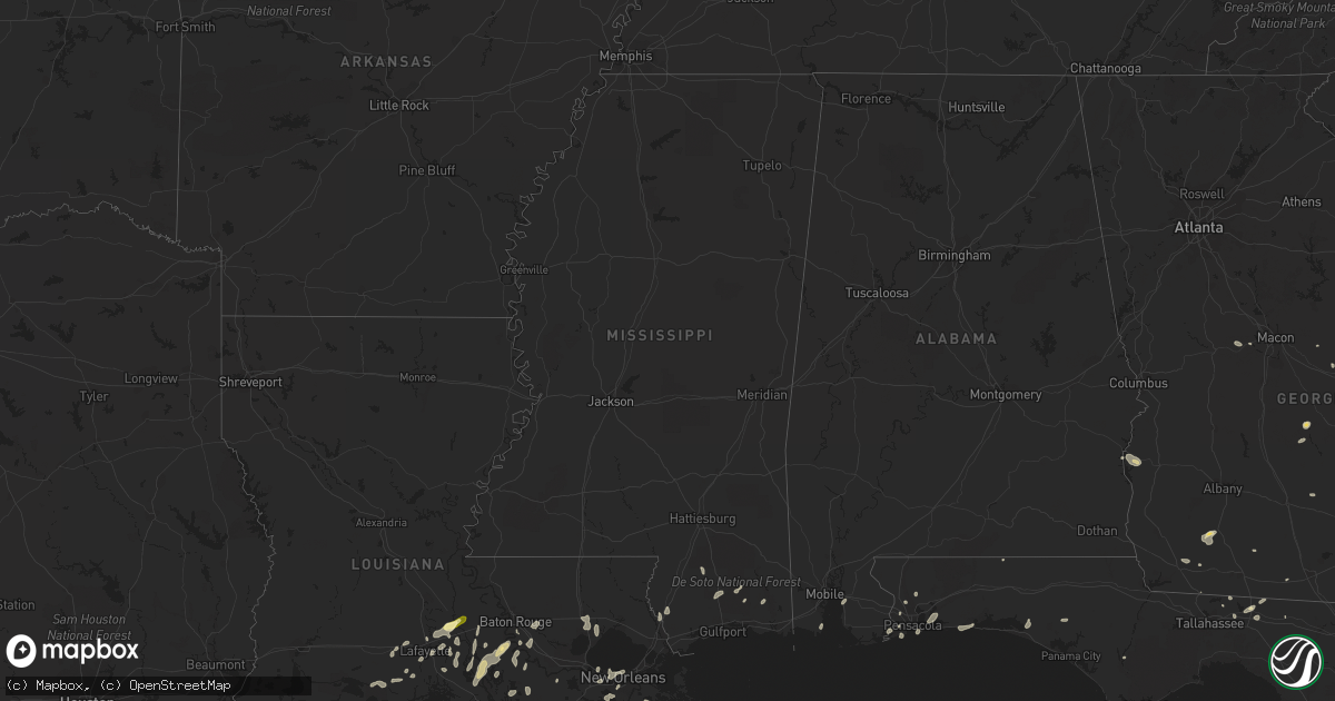
Hail Map in Mississippi on May 19, 2016
Get this storm
May 19 map
$229
one time, instant access
Download today. No call, no setup
Keep the $229
Bought the map and want the full workflow? Apply the entire $229 to a subscription within 7 days. None of it is wasted.
Every map, not just this one
This buys you this map. Subscription and you get every map we run, in the markets you choose from a few cities to whole states to nationwide. Plus real-time alerts the moment a storm fires.
Contact data
Name, contact info, occupancy, even credit band for addresses in the footprint. You go from where it hit to who to call.
Become the source they trust
Unlimited branding weather history reports on demand. You already have the documented answer ready for the property owner, and you are the one who showed up with it.
Property data and RoofTrace estimates
Pull up any address you have got, its value and the exact code rules for that jurisdiction, straight from One Click Code. Then RoofTrace estimates the squares, pitch, and roof value, priced the way you price.
Storm reports in Mississippi
Mississippi
| Date | Description |
|---|---|
| 05/19/201612:56 AM CDT | Trees down on howell tanner chapel rd near both ends. |
| 05/19/201612:55 AM CDT | Tree across the road near old mobile hwy and fred davis rd. |
| 05/19/201612:53 AM CDT | Trees down near hwy 57n and the greene county line |
| 05/19/201612:50 AM CDT | Trees down |
| 05/19/201612:48 AM CDT | Tree down on ruger rd near old riffle range rd. |
| 05/19/201612:44 AM CDT | Trees down on both basin refuge rd and basin central rd. |
| 05/19/201612:30 AM CDT | Tree down across hwy 57s at baston wade rd |
| 05/19/201612:25 AM CDT | Boats blown off trailers at academy sports on lamey bridge road in diberville. Trees also blown down on brandon james drive. Event time approximated. |
| 05/19/201612:23 AM CDT | 40 foot tree snapped and leaned against another tree behind house in d iberville behind city hall. Relayed via social media. |
| 05/19/201612:15 AM CDT | Delayed report of trees blown down on pecan drive and on nicholson avenue in long beach. Event time approximated. |
| 05/18/201611:46 PM CDT | Multiple large pecan trees snapped. Damage to chicken house and pig pen. |
All States Impacted by Hail Map on May 19, 2016
Cities Impacted by Hail Map on May 19, 2016
- Hortense, GA
- Quitman, GA
- Beeville, TX
- Eastman, GA
- Abbeville, GA
- Armstrong, TX
- Tallahassee, FL
- George West, TX
- Lafayette, LA
- Broussard, LA
- Hobson, MT
- Moccasin, MT
- Gulf Breeze, FL
- San Diego, TX
- Asherton, TX
- Mission, TX
- Mcallen, TX
- Westwego, LA
- Marrero, LA
- Maurice, LA
- Linn, TX
- Larose, LA
- Picayune, MS
- Pearl River, LA
- Bainbridge, GA
- Port Barre, LA
- Breaux Bridge, LA
- Taft, TX
- Plaquemine, LA
- Cotulla, TX
- Catarina, TX
- Encinal, TX
- Stanford, MT
- Saint Marys, GA
- Eglin Afb, FL
- Sturgis, SD
- Bristol, FL
- Monticello, FL
- Kingsland, GA
- Woodbine, GA
- Freeport, FL
- Vernon, FL
- Camilla, GA
- Folkston, GA
- Hilliard, FL
- Mary Esther, FL
- Hurlburt Field, FL
- Fort Walton Beach, FL
- Gueydan, LA
- Kaplan, LA
- Pharr, TX
- San Juan, TX
- Alamo, TX
- Jeanerette, LA
- Grosse Tete, LA
- Maringouin, LA
- Coden, AL
- Lumberton, MS
- Wiggins, MS
- Loreauville, LA
- New Iberia, LA
- Saint Martinville, LA
- Theriot, LA
- Lizella, GA
- Baton Rouge, LA
- Krotz Springs, LA
- Ocilla, GA
- Three Rivers, TX
- Houma, LA
- Hammond, LA
- Ponchatoula, LA
- Orlando, FL
- Tilden, TX
- Pensacola, FL
- Lillian, AL
- Port Lavaca, TX
- Crowley, LA
- Cairo, GA
- Dublin, GA
- Montrose, GA
- Saint George, GA
- White Castle, LA
- Saint Gabriel, LA
- Angleton, TX
- Whigham, GA
- Climax, GA
- Morris, GA
- Georgetown, GA
- Clute, TX
- Freeport, TX
- Danbury, TX
- Lake Jackson, TX
- Galveston, TX
- Musella, GA
- Roundup, MT
- Lamont, FL
- Louise, TX
- Lafitte, LA
- Belle Chasse, LA
- Barataria, LA
- Greenville, FL
- Denham Springs, LA
- Chipley, FL
- Saucier, MS
- McHenry, MS
- Vacherie, LA
- Jacksonville, FL
- Morgan City, LA
- Abbeville, LA
- Waynesville, GA
- Rayne, LA
- Vancleave, MS
- Milton, FL
- Napoleonville, LA
- Carriere, MS
- Carrizo Springs, TX
- Cut Off, LA
- Hilger, MT
- Eufaula, AL
- Irwinton, GA
- Daphne, AL
- Bourg, LA
- New Orleans, LA
- Metairie, LA
- Gibson, LA
- Saint Rose, LA
- Sullivan City, TX
- La Joya, TX
- Lagrange, WY
- Laurel Hill, FL
- Mathis, TX
- Coolidge, GA
- Arnaudville, LA
- Geismar, LA
- Gonzales, LA
- Prairieville, LA
- Ama, LA
- Fort Gaines, GA
- Luling, LA
- Screven, GA
- Braithwaite, LA
- Green Cove Springs, FL
- Cantonment, FL
- Perkinston, MS
- Pelham, GA
- Scott, LA
- Donaldsonville, LA
- Belle Rose, LA
- Carville, LA
- Raymondville, TX
- Rochelle, GA
- Ocate, NM
- Yulee, FL
- Fernandina Beach, FL
- Port Saint Joe, FL
- Portland, TX
- Laredo, TX
- Marathon, TX


