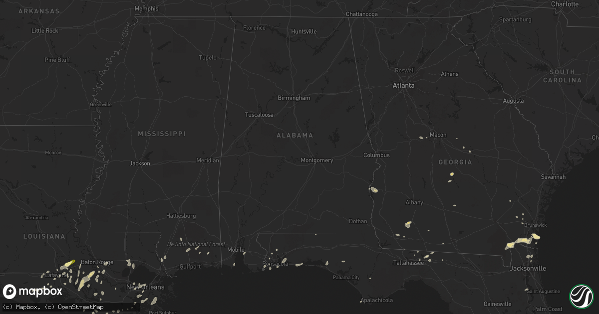
Hail Map in Alabama on May 19, 2016
Get this storm
May 19 map
$229
one time, instant access
Download today. No call, no setup
Keep the $229
Bought the map and want the full workflow? Apply the entire $229 to a subscription within 7 days. None of it is wasted.
Every map, not just this one
This buys you this map. Subscription and you get every map we run, in the markets you choose from a few cities to whole states to nationwide. Plus real-time alerts the moment a storm fires.
Contact data
Name, contact info, occupancy, even credit band for addresses in the footprint. You go from where it hit to who to call.
Become the source they trust
Unlimited branding weather history reports on demand. You already have the documented answer ready for the property owner, and you are the one who showed up with it.
Property data and RoofTrace estimates
Pull up any address you have got, its value and the exact code rules for that jurisdiction, straight from One Click Code. Then RoofTrace estimates the squares, pitch, and roof value, priced the way you price.
Storm reports in Alabama
Alabama
| Date | Description |
|---|---|
| 05/19/20162:42 AM CDT | Trees down on nettlesboro rd near syrene/chance |
| 05/19/20161:48 AM CDT | Trees down near 59 st and shady ln |
| 05/19/20161:44 AM CDT | Trees down near 59 st and shady ln |
| 05/19/20161:44 AM CDT | Trees down across both lanes near brady rd n. And s. White ave. |
| 05/19/20161:37 AM CDT | Tree down on south mcbride |
| 05/19/20161:30 AM CDT | National ocean service - ports observation. |
| 05/19/20161:20 AM CDT | Large tree down near dauphin island pkwy at saltaire dr. |
| 05/19/20161:20 AM CDT | Gorgas at bascombe st... Tree down with powerlines |
| 05/19/20161:20 AM CDT | Tree down on minetrail and power out at 10435 4th street |
| 05/19/20161:16 AM CDT | Trees down near emelda st and pleasant valley rd. |
| 05/19/20161:15 AM CDT | Trees down on hwy 45... 3 miles south of spice pond rd. |
| 05/19/20161:07 AM CDT | Tree down near moffett rd at campbell...near moffett rd and big creek lake...near moffett rd at shelby ln...and black water nursey rd. |
| 05/19/20161:05 AM CDT | Tree down at woddberry and briercliff |
| 05/19/201612:58 AM CDT | Power pole down near 13385 fort lake |
All States Impacted by Hail Map on May 19, 2016
Cities Impacted by Hail Map on May 19, 2016
- Hortense, GA
- Quitman, GA
- Beeville, TX
- Eastman, GA
- Abbeville, GA
- Armstrong, TX
- Tallahassee, FL
- George West, TX
- Lafayette, LA
- Broussard, LA
- Hobson, MT
- Moccasin, MT
- Gulf Breeze, FL
- San Diego, TX
- Asherton, TX
- Mission, TX
- Mcallen, TX
- Westwego, LA
- Marrero, LA
- Maurice, LA
- Linn, TX
- Larose, LA
- Picayune, MS
- Pearl River, LA
- Bainbridge, GA
- Port Barre, LA
- Breaux Bridge, LA
- Taft, TX
- Plaquemine, LA
- Cotulla, TX
- Catarina, TX
- Encinal, TX
- Stanford, MT
- Saint Marys, GA
- Eglin Afb, FL
- Sturgis, SD
- Bristol, FL
- Monticello, FL
- Kingsland, GA
- Woodbine, GA
- Freeport, FL
- Vernon, FL
- Camilla, GA
- Folkston, GA
- Hilliard, FL
- Mary Esther, FL
- Hurlburt Field, FL
- Fort Walton Beach, FL
- Gueydan, LA
- Kaplan, LA
- Pharr, TX
- San Juan, TX
- Alamo, TX
- Jeanerette, LA
- Grosse Tete, LA
- Maringouin, LA
- Coden, AL
- Lumberton, MS
- Wiggins, MS
- Loreauville, LA
- New Iberia, LA
- Saint Martinville, LA
- Theriot, LA
- Lizella, GA
- Baton Rouge, LA
- Krotz Springs, LA
- Ocilla, GA
- Three Rivers, TX
- Houma, LA
- Hammond, LA
- Ponchatoula, LA
- Orlando, FL
- Tilden, TX
- Pensacola, FL
- Lillian, AL
- Port Lavaca, TX
- Crowley, LA
- Cairo, GA
- Dublin, GA
- Montrose, GA
- Saint George, GA
- White Castle, LA
- Saint Gabriel, LA
- Angleton, TX
- Whigham, GA
- Climax, GA
- Morris, GA
- Georgetown, GA
- Clute, TX
- Freeport, TX
- Danbury, TX
- Lake Jackson, TX
- Galveston, TX
- Musella, GA
- Roundup, MT
- Lamont, FL
- Louise, TX
- Lafitte, LA
- Belle Chasse, LA
- Barataria, LA
- Greenville, FL
- Denham Springs, LA
- Chipley, FL
- Saucier, MS
- McHenry, MS
- Vacherie, LA
- Jacksonville, FL
- Morgan City, LA
- Abbeville, LA
- Waynesville, GA
- Rayne, LA
- Vancleave, MS
- Milton, FL
- Napoleonville, LA
- Carriere, MS
- Carrizo Springs, TX
- Cut Off, LA
- Hilger, MT
- Eufaula, AL
- Irwinton, GA
- Daphne, AL
- Bourg, LA
- New Orleans, LA
- Metairie, LA
- Gibson, LA
- Saint Rose, LA
- Sullivan City, TX
- La Joya, TX
- Lagrange, WY
- Laurel Hill, FL
- Mathis, TX
- Coolidge, GA
- Arnaudville, LA
- Geismar, LA
- Gonzales, LA
- Prairieville, LA
- Ama, LA
- Fort Gaines, GA
- Luling, LA
- Screven, GA
- Braithwaite, LA
- Green Cove Springs, FL
- Cantonment, FL
- Perkinston, MS
- Pelham, GA
- Scott, LA
- Donaldsonville, LA
- Belle Rose, LA
- Carville, LA
- Raymondville, TX
- Rochelle, GA
- Ocate, NM
- Yulee, FL
- Fernandina Beach, FL
- Port Saint Joe, FL
- Portland, TX
- Laredo, TX
- Marathon, TX


