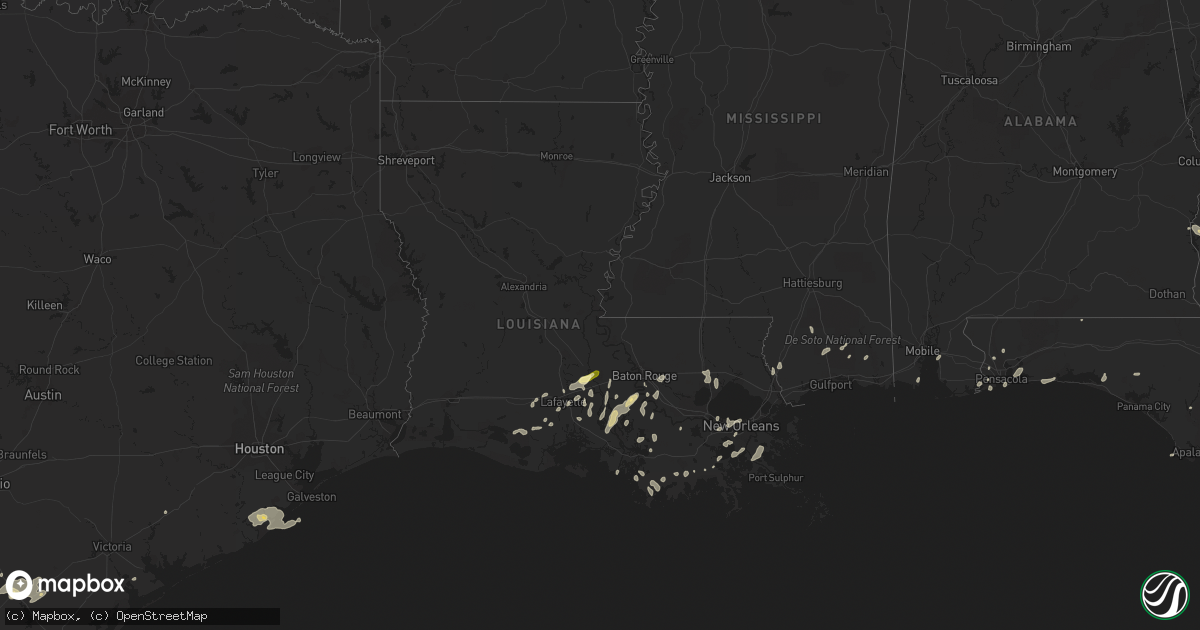
Hail Map in Louisiana on May 19, 2016
Get this storm
May 19 map
$229
one time, instant access
Download today. No call, no setup
Keep the $229
Bought the map and want the full workflow? Apply the entire $229 to a subscription within 7 days. None of it is wasted.
Every map, not just this one
This buys you this map. Subscription and you get every map we run, in the markets you choose from a few cities to whole states to nationwide. Plus real-time alerts the moment a storm fires.
Contact data
Name, contact info, occupancy, even credit band for addresses in the footprint. You go from where it hit to who to call.
Become the source they trust
Unlimited branding weather history reports on demand. You already have the documented answer ready for the property owner, and you are the one who showed up with it.
Property data and RoofTrace estimates
Pull up any address you have got, its value and the exact code rules for that jurisdiction, straight from One Click Code. Then RoofTrace estimates the squares, pitch, and roof value, priced the way you price.
Storm reports in Louisiana
Louisiana
| Date | Description |
|---|---|
| 05/18/201611:15 PM CDT | Tree on car on g street. |
| 05/18/201611:10 PM CDT | Large tree down on lakeview drive. |
| 05/18/201611:00 PM CDT | Large limbs down...wood fences blown down and minor roof damage. Location is in montgomery terrace subdivision off of highway 22. |
| 05/18/201610:30 PM CDT | Large tree down and personal weather station measured 68 mph wind gust in shenandoah area of baton rouge. |
| 05/18/201610:25 PM CDT | Power lines down near east st. John high school. Relayed via social media. |
| 05/18/201610:20 PM CDT | Trees and power lines down along hwy 308 near valentine. Time estimated from radar. |
| 05/18/201610:20 PM CDT | Trees down along 4h club rd in denham springs. Reported via social media. |
| 05/18/201610:20 PM CDT | A line of storms produced severe straight line winds near 70 mph south to north across the shenandoah area along jones creek road. Large trees were uprooted and there w |
| 05/18/201610:17 PM CDT | Trees down along hwy 61 near sorrento. |
| 05/18/201610:05 PM CDT | Damage throughout terrebonne. Power lines down in montegut. Trees down in houma. Power lines down and carport damaged in chauvin. Time estimated from radar. |
| 05/18/201610:05 PM CDT | Tree down on home off s. Peck drive in south baton rouge. Relayed via social media. |
| 05/18/201610:03 PM CDT | Trees reported down on numerous roads/highways around convent and vacherie in st. James parish. House roof blown off in st. James. Rv flipped and two others blown off j |
| 05/18/201610:02 PM CDT | Tree down through roof of house in trailer park. 10 trees down across lafourche parish. |
| 05/18/20169:45 PM CDT | Broken windows... Roof and porch damage along hwy 401/canal rd near lake veret. Time estimated from radar. |
| 05/18/20169:30 PM CDT | A line of storms tracking sw to ne along hwy 401 produced a downbusrt. The storm survey found evidence of widespread straight line wind damage near 70 mph with isolated |
| 05/18/20169:29 PM CDT | Kwbj reports power lines down on california street and posted photo of a gas station awning structure on the ground. |
| 05/18/20169:25 PM CDT | Trained spotter reports tree down on a home on cane st in bayou vista. |
| 05/18/20168:50 PM CDT | Traffic signal on pole snapped. |
| 05/18/20168:45 PM CDT | Katc reports 60 mph wind gust. |
| 05/18/20168:45 PM CDT | Several photos of large trees down in lafayette. |
| 05/18/20168:24 PM CDT | Cwop station in abbeville measured a wind gust of 70 mph. |
| 05/18/20168:19 PM CDT | Public reports 65 mph wind gust measured with personal weather station...id c2220. Trees were snapped from the gust. |
| 05/18/20168:18 PM CDT | Cwop station in abbeville measured a wind gust of 70 mph. |
| 05/18/20168:08 PM CDT | Cwop station in abbeville measured a wind gust of 59 mph. |
| 05/18/20167:56 PM CDT | Public measured an 81 mph wind gust on home weather station. Time estimated from radar. |
| 05/18/20167:47 PM CDT | Quarter sized hail reported via social media. |
All States Impacted by Hail Map on May 19, 2016
Cities Impacted by Hail Map on May 19, 2016
- Hortense, GA
- Quitman, GA
- Beeville, TX
- Eastman, GA
- Abbeville, GA
- Armstrong, TX
- Tallahassee, FL
- George West, TX
- Lafayette, LA
- Broussard, LA
- Hobson, MT
- Moccasin, MT
- Gulf Breeze, FL
- San Diego, TX
- Asherton, TX
- Mission, TX
- Mcallen, TX
- Westwego, LA
- Marrero, LA
- Maurice, LA
- Linn, TX
- Larose, LA
- Picayune, MS
- Pearl River, LA
- Bainbridge, GA
- Port Barre, LA
- Breaux Bridge, LA
- Taft, TX
- Plaquemine, LA
- Cotulla, TX
- Catarina, TX
- Encinal, TX
- Stanford, MT
- Saint Marys, GA
- Eglin Afb, FL
- Sturgis, SD
- Bristol, FL
- Monticello, FL
- Kingsland, GA
- Woodbine, GA
- Freeport, FL
- Vernon, FL
- Camilla, GA
- Folkston, GA
- Hilliard, FL
- Mary Esther, FL
- Hurlburt Field, FL
- Fort Walton Beach, FL
- Gueydan, LA
- Kaplan, LA
- Pharr, TX
- San Juan, TX
- Alamo, TX
- Jeanerette, LA
- Grosse Tete, LA
- Maringouin, LA
- Coden, AL
- Lumberton, MS
- Wiggins, MS
- Loreauville, LA
- New Iberia, LA
- Saint Martinville, LA
- Theriot, LA
- Lizella, GA
- Baton Rouge, LA
- Krotz Springs, LA
- Ocilla, GA
- Three Rivers, TX
- Houma, LA
- Hammond, LA
- Ponchatoula, LA
- Orlando, FL
- Tilden, TX
- Pensacola, FL
- Lillian, AL
- Port Lavaca, TX
- Crowley, LA
- Cairo, GA
- Dublin, GA
- Montrose, GA
- Saint George, GA
- White Castle, LA
- Saint Gabriel, LA
- Angleton, TX
- Whigham, GA
- Climax, GA
- Morris, GA
- Georgetown, GA
- Clute, TX
- Freeport, TX
- Danbury, TX
- Lake Jackson, TX
- Galveston, TX
- Musella, GA
- Roundup, MT
- Lamont, FL
- Louise, TX
- Lafitte, LA
- Belle Chasse, LA
- Barataria, LA
- Greenville, FL
- Denham Springs, LA
- Chipley, FL
- Saucier, MS
- McHenry, MS
- Vacherie, LA
- Jacksonville, FL
- Morgan City, LA
- Abbeville, LA
- Waynesville, GA
- Rayne, LA
- Vancleave, MS
- Milton, FL
- Napoleonville, LA
- Carriere, MS
- Carrizo Springs, TX
- Cut Off, LA
- Hilger, MT
- Eufaula, AL
- Irwinton, GA
- Daphne, AL
- Bourg, LA
- New Orleans, LA
- Metairie, LA
- Gibson, LA
- Saint Rose, LA
- Sullivan City, TX
- La Joya, TX
- Lagrange, WY
- Laurel Hill, FL
- Mathis, TX
- Coolidge, GA
- Arnaudville, LA
- Geismar, LA
- Gonzales, LA
- Prairieville, LA
- Ama, LA
- Fort Gaines, GA
- Luling, LA
- Screven, GA
- Braithwaite, LA
- Green Cove Springs, FL
- Cantonment, FL
- Perkinston, MS
- Pelham, GA
- Scott, LA
- Donaldsonville, LA
- Belle Rose, LA
- Carville, LA
- Raymondville, TX
- Rochelle, GA
- Ocate, NM
- Yulee, FL
- Fernandina Beach, FL
- Port Saint Joe, FL
- Portland, TX
- Laredo, TX
- Marathon, TX


