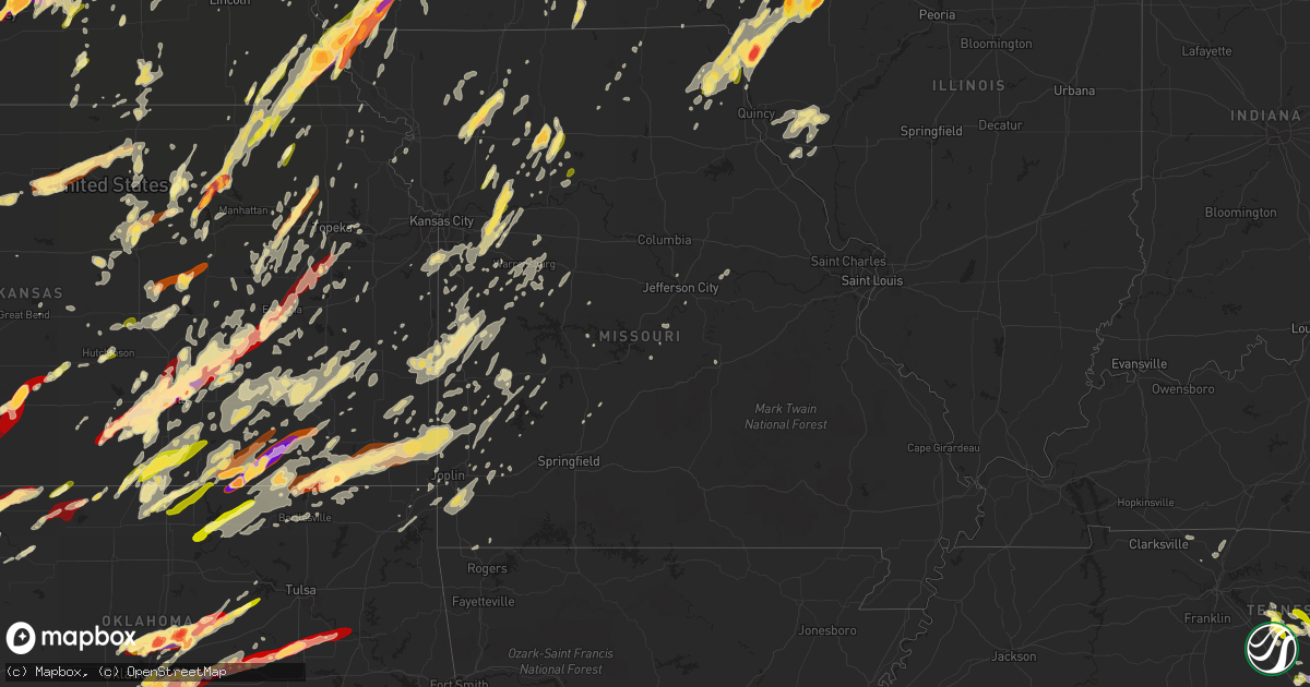
Hail Map in Missouri on May 19, 2013
Get this storm
May 19 map
$229
one time, instant access
Download today. No call, no setup
Keep the $229
Bought the map and want the full workflow? Apply the entire $229 to a subscription within 7 days. None of it is wasted.
Every map, not just this one
This buys you this map. Subscription and you get every map we run, in the markets you choose from a few cities to whole states to nationwide. Plus real-time alerts the moment a storm fires.
Contact data
Name, contact info, occupancy, even credit band for addresses in the footprint. You go from where it hit to who to call.
Become the source they trust
Unlimited branding weather history reports on demand. You already have the documented answer ready for the property owner, and you are the one who showed up with it.
Property data and RoofTrace estimates
Pull up any address you have got, its value and the exact code rules for that jurisdiction, straight from One Click Code. Then RoofTrace estimates the squares, pitch, and roof value, priced the way you price.
Storm reports in Missouri
Missouri
| Date | Description |
|---|---|
| 05/19/20135:07 PM CDT | Also wind gusts estimated to be over 50 mph from the west southwest and very heavy rain. |
| 05/19/20134:56 PM CDT | Also 60 to 70 mph winds |
| 05/19/20134:31 PM CDT | Observers comments....fast moving storm hail lasted only a brief period. |
| 05/19/20134:26 PM CDT | A local report indicates 1.75 inch wind near 2 W WESTBORO |
| 05/19/20134:08 PM CDT | A local report indicates 1.00 inch wind near ROCKPORT |
| 05/19/20134:02 PM CDT | A local report indicates 1.00 inch wind near ROCKPORT |
| 05/19/20133:43 AM CDT | Several trees and power lines down in black jack. Tree blocking the road on new hallsferry near douglas road. |
| 05/19/20133:38 AM CDT | Tree snapped off. Minor roof and gutter damage. |
| 05/19/20133:29 AM CDT | Few trees blown over reported by public on facebook. |
| 05/19/20133:15 AM CDT | Several trees down near intersection of highway 94 and highway dd near defiance. |
| 05/19/20133:07 AM CDT | Three or four power poles have been snapped off along old highway 100 and highway t. Time approximate from radar. |
| 05/19/20131:30 AM CDT | Trees down across road at 270 falling rock road. |
| 05/19/20131:20 AM CDT | Trees uprooted near granger lane. |
| 05/19/20131:06 AM CDT | Power line down. Location and time estimated. |
| 05/19/20131:05 AM CDT | Two power lines snapped off and over the road at highway 83 and 425th road. |
| 05/19/201312:48 AM CDT | Barn completely destroyed |
| 05/19/201312:39 AM CDT | Tree reported fallen on car. |
| 05/19/201312:37 AM CDT | 60 mph winds estimated along with dime sized hail. |
| 05/19/201312:32 AM CDT | 55kt gust measured at knvd |
| 05/19/201312:25 AM CDT | Several outbuildings damaged. Grocery store roof damaged. Carport damaged in town with several trees down. Time of event estimated. |
| 05/19/201312:25 AM CDT | Emergency manager from barton county reported a cone tornado 1 mile south of highway 126 approximately 2 miles east of golden city...moving east. |
| 05/19/201312:23 AM CDT | An ef-0 tornado touched down on the west side of lockwood at the golf course and city pool area. This tornado tracked east-northeast to the north end of sycamore st. A |
| 05/19/201312:12 AM CDT | Tree down across bb highway in nevada. |
| 05/19/201312:06 AM CDT | Tree reported down on house. |
| 05/19/201312:06 AM CDT | Nws storm survey confirmed a tornado touched down briefly near the intersection of palimino and 13th street approximately 2 miles east of carthage. Numerous trees were |
| 05/19/201312:06 AM CDT | Numerous trees down...powerlines down...outbuildings destroyed...and shingle damage to homes. Time of event estimated. |
| 05/19/201312:06 AM CDT | Tree reported down on house at intersection of chestnut and 118. |
| 05/19/201312:02 AM CDT | Road sign down at i-49 and fir road |
| 05/18/201311:57 PM CDT | Tree down across roadway |
| 05/18/201310:47 PM CDT | 6 large utility power poles down as well as a large tree. Time is estimated. |
| 05/18/201310:40 PM CDT | Uprooted trees with several branches down 4 to 5 inches in diameter. |
| 05/18/201310:24 PM CDT | Trees down in adrian. Time is estimated. |
| 05/18/20139:45 PM CDT | Widespread tree damage across schuyler county. Tractor trailer blown over. |
| 05/18/20139:45 PM CDT | Delayed report...half of the roof ripped off of a 150 foot long hog confinement building. Unknown number of dead hogs. |
| 05/18/20139:35 PM CDT | Roof torn off commercial building and debris on highway 6...multiple power outages in and around edina |
| 05/18/20139:30 PM CDT | Roof damage reported to a commercial building in edina. Wind gusts in the area were estimated around 50 mph. |
| 05/18/20139:13 PM CDT | 60 to 70 mph winds...powerlines down. |
| 05/18/20138:59 PM CDT | Very large tree blown down. It required a tractor to move it out of the way. |
| 05/18/20138:58 PM CDT | Roof blown off house |
| 05/18/20138:41 PM CDT | Several trees and limbs down across the city |
| 05/18/20138:30 PM CDT | A local report indicates 60 MPH wind near GALLATIN |
| 05/18/20138:25 PM CDT | 60 mph wnd gusts |
| 05/18/20138:17 PM CDT | Overhead door at cameron ems blown in. Reports of trees down in cameron. |
| 05/18/20138:16 PM CDT | Also with 45 mph winds |
| 05/18/20138:11 PM CDT | A local report indicates 1.00 inch wind near BOSWORTH |
| 05/18/20138:00 PM CDT | A local report indicates 1.75 inch wind near CHILLICOTHE |
| 05/18/20137:58 PM CDT | A local report indicates 60 MPH wind near 5 NW GILMAN CITY |
| 05/18/20137:58 PM CDT | Power poles down...delayed report |
| 05/18/20137:55 PM CDT | 4 inch diameter tree snapped |
| 05/18/20137:50 PM CDT | Trees and powerlines down at english landing park |
| 05/18/20137:50 PM CDT | A local report indicates 62 MPH wind near WHITEMAN AFB |
| 05/18/20137:45 PM CDT | 65 mph winds...roof caps blow off...street lights blow off pole..lawn furniture blown away. All occurred at 133 and state line. |
| 05/18/20137:45 PM CDT | A local report indicates 60 MPH wind near 4 NW LIBERTY |
| 05/18/20137:45 PM CDT | 65 mph winds...roof caps blow off...street lights blown off pole...lawn furniture blown away. All occurred at 133rd and state line. |
| 05/18/20137:43 PM CDT | 58 to 60 mph winds...two 30 ft.trees blown down. |
| 05/18/20137:40 PM CDT | A local report indicates 60 MPH wind near GRANDVIEW |
| 05/18/20137:40 PM CDT | 12 inch diameter limbs down near i435 and gregory |
| 05/18/20137:39 PM CDT | Numerous trees down in the weston area along and blocking 45 to buchanan county line |
| 05/18/20137:38 PM CDT | A local report indicates 1.50 inch wind near 3 N WINSTON |
| 05/18/20137:38 PM CDT | Trees and powerlines down |
| 05/18/20137:38 PM CDT | Measured 59 knot winds at kansas city downtown airport |
| 05/18/20137:37 PM CDT | A local report indicates 68 MPH wind near KANSAS CITY |
| 05/18/20137:32 PM CDT | A local report indicates 59 MPH wind near ST. JOSEPH |
| 05/18/20137:15 PM CDT | Power poles down |
| 05/18/20137:05 PM CDT | Large tree blown over...estimated 60 mph winds |
All States Impacted by Hail Map on May 19, 2013
Cities Impacted by Hail Map on May 19, 2013
- Deerfield, WI
- Davenport, IA
- Clarksville, IA
- Plainfield, IA
- Allison, IA
- Greene, IA
- Clinton, IA
- Sabula, IA
- Miles, IA
- Two Rivers, WI
- Cushing, OK
- Drumright, OK
- Media, IL
- Wamego, KS
- Belvue, KS
- Lost Nation, IA
- Wheatland, IA
- Calamus, IA
- Grand Mound, IA
- Turon, KS
- Holden, MO
- Kingsville, MO
- Deweese, NE
- Guntersville, AL
- Sparta, TN
- Quebeck, TN
- Doyle, TN
- Walling, TN
- Smithville, TN
- Spencer, TN
- Rock Island, TN
- Forestville, WI
- Algoma, WI
- Cumberland, IA
- Villisca, IA
- Corning, IA
- Carbon, IA
- Massena, IA
- Nodaway, IA
- Dexter, KS
- Reedsburg, WI
- Seymour, WI
- Hollywood, AL
- Stevenson, AL
- Fackler, AL
- Pisgah, AL
- Flat Rock, AL
- Haskell, OK
- Gladstone, IL
- Carman, IL
- Rosalia, KS
- Leon, KS
- Coin, IA
- Mindoro, WI
- Hodgenville, KY
- Sylvia, KS
- Iuka, KS
- Pratt, KS
- Byers, KS
- Grand Island, NE
- Keokuk, IA
- Burlington, IA
- Nora Springs, IA
- Couderay, WI
- Terlton, OK
- Cleveland, OK
- Oklahoma City, OK
- Downs, KS
- Tipton, KS
- Beloit, KS
- Randall, KS
- Osborne, KS
- Glen Elder, KS
- Jewell, KS
- Scottsville, KY
- Andalusia, IL
- Reynolds, IL
- Illinois City, IL
- Milan, IL
- Taylor Ridge, IL
- Leeton, MO
- Dodge City, KS
- Ensign, KS
- Riley, KS
- Bronaugh, MO
- Liberal, MO
- Osmond, NE
- Pierce, NE
- Ravenna, NE
- Williamsburg, KS
- Topeka, KS
- Medford, OK
- Caldwell, KS
- Bellevue, IA
- Delphos, KS
- Concordia, KS
- Aurora, KS
- Little Cedar, IA
- Osage, IA
- Rudd, IA
- Laverne, OK
- Cedar Point, KS
- Colwich, KS
- Norwich, KS
- Potwin, KS
- Garden Plain, KS
- Mayfield, KS
- Kingman, KS
- Burns, KS
- El Dorado, KS
- Maize, KS
- Augusta, KS
- Goddard, KS
- Clearwater, KS
- Argonia, KS
- Cottonwood Falls, KS
- Conway Springs, KS
- Peck, KS
- Viola, KS
- Wichita, KS
- Towanda, KS
- Valley Center, KS
- Matfield Green, KS
- Haysville, KS
- Whitewater, KS
- Andover, KS
- Cheney, KS
- Wellington, KS
- Kechi, KS
- Benton, KS
- Milton, KS
- Greenwich, KS
- Cassoday, KS
- Rockford, IA
- Mason City, IA
- Norman, OK
- Newcastle, OK
- Blanchard, OK
- Hutchinson, KS
- Odessa, MO
- Lone Jack, MO
- Hardin, MO
- Pleasant Hill, MO
- Henrietta, MO
- Richmond, MO
- Oak Grove, MO
- Greenwood, MO
- Mayview, MO
- Napoleon, MO
- Bates City, MO
- Wellington, MO
- Camden, MO
- Lexington, MO
- Lees Summit, MO
- Little York, IL
- Oquawka, IL
- Seaton, IL
- Collyer, KS
- Wakeeney, KS
- Oliver Springs, TN
- Briceville, TN
- Clinton, TN
- Glasgow, KY
- Eighty Eight, KY
- Hillsdale, IL
- Colona, IL
- Glenwood, IA
- Murray, NE
- McClelland, IA
- Plattsmouth, NE
- Underwood, IA
- Nehawka, NE
- Neola, IA
- Pacific Junction, IA
- Bellevue, NE
- Offutt Afb, NE
- Weeping Water, NE
- Council Bluffs, IA
- Manor, GA
- Millwood, GA
- Oakdale, TN
- Harriman, TN
- Natoma, KS
- Paradise, KS
- Waldo, KS
- Oxford, KS
- Joplin, MO
- Mulberry, KS
- Ocala, FL
- Lamar, MO
- Wakita, OK
- Manchester, OK
- Dallas Center, IA
- Elkland, MO
- Buffalo, MO
- Luther, OK
- Wellston, OK
- Arcadia, OK
- Guthrie, OK
- Meridian, OK
- Edmond, OK
- Piedmont, OK
- Coldwater, KS
- Pawhuska, OK
- Shorter, AL
- Hardaway, AL
- Arkansas City, KS
- Onalaska, WI
- Mooreland, OK
- Buffalo, OK
- Alva, OK
- Freedom, OK
- Bouton, IA
- Perry, IA
- Gresham, NE
- Utica, NE
- Lynn Center, IL
- Orion, IL
- Salem, IA
- Saint Marys, KS
- Rossville, KS
- Scottsboro, AL
- Alma, WI
- Cochrane, WI
- Mcminnville, TN
- Braman, OK
- South Haven, KS
- Guide Rock, NE
- Burr Oak, KS
- Milton, IA
- Memphis, MO
- Alexis, IL
- Gerlaw, IL
- Polo, MO
- Hamburg, IA
- Saint Charles, IA
- Indianola, IA
- Prole, IA
- New Virginia, IA
- Banks, AL
- Union Springs, AL
- Burlingame, KS
- Rockford, IL
- Dacoma, OK
- Tampa, KS
- Hope, KS
- Scales Mound, IL
- Galena, IL
- Grandview, IA
- Wapello, IA
- Letts, IA
- Columbus Junction, IA
- Mitchellville, IA
- Perry, KS
- Lecompton, KS
- Morrison, TN
- Holcomb, KS
- Garden City, KS
- Centerville, KS
- Osage City, KS
- Lebo, KS
- Lyndon, KS
- Appleton, WI
- Kaukauna, WI
- Bennington, KS
- Tescott, KS
- Hot Springs, NC
- Charles City, IA
- Edwards, MO
- Burwell, NE
- Fredonia, KS
- Virgil, KS
- Yates Center, KS
- Fall River, KS
- Toronto, KS
- Huxley, IA
- Cambridge, IA
- Clay Center, KS
- Mount Morris, IL
- Forreston, IL
- Leaf River, IL
- Haviland, KS
- Salina, KS
- Brookville, KS
- Ellinwood, KS
- Claflin, KS
- Peachtree City, GA
- Sharpsburg, GA
- Washington, IA
- Keota, IA
- Brighton, IA
- Steinauer, NE
- Brock, NE
- Elk Creek, NE
- Pawnee City, NE
- Johnson, NE
- Tecumseh, NE
- Burchard, NE
- Farmington, IA
- Wayland, MO
- Donnellson, IA
- Argyle, IA
- Silver Creek, NE
- Delia, KS
- Bridgewater, IA
- Prescott, IA
- Belvidere, NE
- Bernard, IA
- Zwingle, IA
- Dubuque, IA
- Maquoketa, IA
- Morganville, KS
- Lehigh, KS
- Canton, KS
- Moundridge, KS
- Galva, KS
- Hillsboro, KS
- Sedgwick, KS
- Montezuma, KS
- Copeland, KS
- Cimarron, KS
- Kirkwood, IL
- Biggsville, IL
- Raritan, IL
- Smithshire, IL
- Stronghurst, IL
- Emporia, KS
- Lexington, NE
- Winfield, IA
- Union Grove, AL
- Osceola, MO
- El Dorado Springs, MO
- Cumming, IA
- West Des Moines, IA
- Riceville, IA
- Prescott, KS
- Hume, MO
- Shelton, NE
- Wood River, NE
- Polk City, IA
- Holy Cross, IA
- Glen Haven, WI
- North Buena Vista, IA
- Sherrill, IA
- Cassville, WI
- Quinter, KS
- Park, KS
- Choctaw, OK
- Amber, OK
- Trion, GA
- Minneapolis, KS
- Fall Creek, WI
- Corning, KS
- Centralia, KS
- Liberty, IL
- Pleasanton, NE
- Gibbon, NE
- Elbing, KS
- Newton, KS
- Maple Hill, KS
- Silver Lake, KS
- Winston, MO
- Pattonsburg, MO
- Weatherby, MO
- Altamont, MO
- Ludowici, GA
- Nicholls, GA
- Waycross, GA
- Mcloud, OK
- Shawnee, OK
- Saint Ansgar, IA
- Plymouth, IA
- Stacyville, IA
- Rockwell, IA
- Mount Pleasant, IA
- Knob Noster, MO
- Whiteman Air Force Base, MO
- Randolph, NE
- Winnebago, IL
- Pecatonica, IL
- Garrison, IA
- Vinton, IA
- Meadow Grove, NE
- West Chester, IA
- Bradyville, TN
- Readyville, TN
- Somers, IA
- Rockwell City, IA
- Knierim, IA
- Manson, IA
- Gravity, IA
- De Soto, IA
- Blue Rapids, KS
- Rock Port, MO
- Home, KS
- Des Moines, IA
- Winterset, IA
- Auburn, NE
- Nevada, IA
- Tarkio, MO
- Riverton, IA
- Van Meter, IA
- Booneville, IA
- Waterville, KS
- Abilene, KS
- Frankfort, KS
- Marysville, KS
- Waukee, IA
- Orient, IA
- Sheldahl, IA
- Slater, IA
- Minburn, IA
- Verdon, NE
- Westboro, MO
- Clarinda, IA
- Kelley, IA
- Vermillion, KS
- Axtell, KS
- Greenfield, IA
- Ames, IA
- Chapman, KS
- Dexter, IA
- Clive, IA
- Beattie, KS
- Elkhart, IA
- Stella, NE
- Seneca, KS
- Manhattan, KS
- Urbandale, IA
- Shubert, NE
- Nemaha, NE
- Menlo, IA
- Du Bois, NE
- Shenandoah, IA
- Stuart, IA
- Westmoreland, KS
- Granger, IA
- Liberty, NE
- Adel, IA
- Olsburg, KS
- Brownville, NE
- Norwalk, IA
- Grimes, IA
- Creston, IA
- Adair, IA
- Falls City, NE
- Ankeny, IA
- Yorktown, IA
- Fairfax, MO
- Milford, KS
- Essex, IA
- Leonardville, KS
- Redfield, IA
- Baileyville, KS
- Summerfield, KS
- Bedford, IA
- Humboldt, NE
- Watson, MO
- Northboro, IA
- Farragut, IA
- Talmage, NE
- Woodward, IA
- Stanton, IA
- Madrid, IA
- Linden, IA
- Table Rock, NE
- Johnston, IA
- Nebraska City, NE
- Casey, IA
- Earlham, IA
- Alleman, IA
- Peru, NE
- Blanchard, IA
- Windsor Heights, IA
- Randolph, KS
- Anita, IA
- Wakefield, KS
- Fontanelle, IA
- Lakin, KS
- Novinger, MO
- Green Castle, MO
- Piedmont, KS
- Atlanta, KS
- Latham, KS
- Cameron, IL
- Galesburg, IL
- Osceola, IA
- Hamilton, IL
- Nauvoo, IL
- Warsaw, IL
- Alexandria, MO
- Wymore, NE
- Warrensburg, MO
- Chilhowee, MO
- Centerview, MO
- Butler, MO
- Spring Hill, KS
- Osceola, NE
- Coffeyville, KS
- Independence, KS
- Wann, OK
- S Coffeyville, OK
- Liberty, KS
- Saint Elizabeth, MO
- Eugene, MO
- Williamstown, MO
- Montrose, IA
- Carthage, IL
- Edina, MO
- Kahoka, MO
- Keithsburg, IL
- Knox City, MO
- Rutledge, MO
- Monmouth, IL
- Danville, IA
- Saint Patrick, MO
- Wyaconda, MO
- Canton, MO
- Middletown, IA
- Lewistown, MO
- West Burlington, IA
- Dallas City, IL
- La Belle, MO
- Fort Madison, IA
- Niota, IL
- Lomax, IL
- Monticello, MO
- West Point, IA
- La Harpe, IL
- Wever, IA
- Oakville, IA
- Denmark, IA
- Chattanooga, TN
- Wildwood, GA
- Lookout Mountain, GA
- Carney, OK
- Cashion, OK
- Okarche, OK
- Sabetha, KS
- Palmer, NE
- Saint Libory, NE
- Saint Paul, NE
- Dannebrog, NE
- New London, IA
- Blackwell, OK
- Alma, KS
- Allen, KS
- Black Creek, WI
- Rising Fawn, GA
- Caney, KS
- Chatsworth, GA
- Dalton, GA
- Bryant, AL
- Bridgeport, AL
- Higdon, AL
- Hebron, NE
- Bruning, NE
- Alexandria, NE
- Satanta, KS
- Ulysses, KS
- Conrad, IA
- Liscomb, IA
- Marshalltown, IA
- Hale, MO
- Eldridge, IA
- Bettendorf, IA
- Le Claire, IA
- Eddyville, NE
- Cozad, NE
- Lancaster, WI
- Potosi, WI
- Hoxie, KS
- Wolbach, NE
- Clifton, KS
- Newark, MO
- Fair Grove, MO
- Montrose, MO
- Leesburg, FL
- Newman Grove, NE
- Saint Edward, NE
- Albion, NE
- Freeport, IL
- Oregon, IL
- Harrah, OK
- Meeker, OK
- Prague, OK
- Newalla, OK
- Sparks, OK
- Graysville, TN
- Dayton, TN
- Ord, NE
- Ericson, NE
- North Loup, NE
- Scotia, NE
- Mound Valley, KS
- Edna, KS
- Rockton, IL
- Rose Creek, MN
- Austin, MN
- Brownsdale, MN
- Dexter, MN
- Lyle, MN
- Dixon, IL
- Amboy, IL
- Franklin Grove, IL
- Screven, GA
- Patterson, GA
- Woodbury, TN
- Olpe, KS
- Lorimor, IA
- Perkins, OK
- Collins, MO
- Mayetta, KS
- Eskridge, KS
- Paxico, KS
- Holton, KS
- Troy, AL
- Brundidge, AL
- Thomasville, GA
- Tryon, OK
- Agra, OK
- Crawfordsville, IA
- Wayland, IA
- Russell, IA
- Chariton, IA
- Jamestown, KS
- Chautauqua, KS
- Sedan, KS
- Peru, KS
- Cedar Vale, KS
- Sarcoxie, MO
- Stotts City, MO
- Wentworth, MO
- Newkirk, OK
- Deer Creek, OK
- Nardin, OK
- Elma, IA
- Boston, GA
- York, NE
- Peterson, MN
- Rockville, MO
- Harwood, MO
- Walker, MO
- Schell City, MO
- Readlyn, IA
- Delta, IA
- Peculiar, MO
- Harrisonville, MO
- Durango, IA
- Peosta, IA
- Platteville, WI
- Lake City, MN
- Stockholm, WI
- Burlington, OK
- Belleville, KS
- Munden, KS
- Longford, KS
- Alda, NE
- Rich Hill, MO
- Richards, MO
- Chester, OK
- Tifton, GA
- Cameron, MO
- Radcliff, KY
- Elizabethtown, KY
- Humphrey, NE
- Platte Center, NE
- Rome, GA
- Scammon, KS
- Parsons, KS
- Frontenac, KS
- West Mineral, KS
- Dearing, KS
- Copan, OK
- Columbus, KS
- Oronogo, MO
- Mindenmines, MO
- Cherryvale, KS
- Tyro, KS
- Altamont, KS
- Cherokee, KS
- McCune, KS
- Pittsburg, KS
- Oswego, KS
- Opolis, KS
- Asbury, MO
- Weir, KS
- Niotaze, KS
- Greenfield, MO
- Onaga, KS
- State Center, IA
- Le Roy, KS
- Neosho Falls, KS
- Neal, KS
- Eureka, KS
- Severy, KS
- Sperry, IA
- Yarmouth, IA
- Oak Ridge, TN
- Knoxville, TN
- Quenemo, KS
- Vassar, KS
- Harrison, TN
- Soddy Daisy, TN
- Tuskegee, AL
- Marshall, WI
- Guttenberg, IA
- Okmulgee, OK
- Okemah, OK
- Beggs, OK
- Mankato, KS
- Oneida, IL
- Wataga, IL
- Windsor, MO
- Elyria, NE
- Notasulga, AL
- Folkston, GA
- Elgin, NE
- Petersburg, NE
- Winchester, KY
- Savanna, IL
- Republic, KS
- Holmen, WI
- Galesville, WI
- Melrose, WI
- Blair, WI
- Ettrick, WI
- Taylor, WI
- Hixton, WI
- Pierceville, KS
- Bloomington, WI
- Fort Davis, AL
- East Moline, IL
- Buffalo, KY
- Louisville, AL
- Stockton, MO
- Humansville, MO
- Dixie, GA
- Stone Lake, WI
- Thomaston, GA
- Lockwood, MO
- Golden City, MO
- Jerico Springs, MO
- Hillsboro, TN
- Milton, TN
- Mount Sterling, IL
- Clayton, IL
- Versailles, IL
- Giltner, NE
- Wausa, NE
- Sauk City, WI
- Mazomanie, WI
- Epworth, IA
- Manchester, TN
- Albany, MO
- Rulo, NE
- White Cloud, KS
- Monroe, NE
- Fort Scott, KS
- Foster, MO
- Avoca, NE
- Lawrence, NE
- Glenvil, NE
- Fairfield, NE
- Altura, MN
- Saint Charles, MN
- Dover, MN
- Minnesota City, MN
- Fountain City, WI
- Rollingstone, MN
- Clermont, FL
- Miami, OK
- Pleasant Hill, IA
- Waco, NE
- Lawson, MO
- Rayville, MO
- Alta Vista, IA
- Lime Springs, IA
- Dougherty, IA
- Le Roy, MN
- Floyd, IA
- Orchard, IA
- Taopi, MN
- Chester, IA
- Adams, MN
- McIntire, IA
- Columbus, NE
- Madison, NE
- Creston, NE
- Lindsay, NE
- Everest, KS
- Robinson, KS
- Sewanee, TN
- Dakota, MN
- La Crescent, MN
- Moline, IL
- Rock Island, IL
- Neosho, MO
- Maysville, MO
- Hortense, GA
- Odum, GA
- Bristol, GA
- Surrency, GA
- Florahome, FL
- Palatka, FL
- Whiting, KS
- Mount Auburn, IA
- Central City, NE
- Fullerton, NE
- Chillicothe, MO
- Chula, MO
- Wheeling, MO
- Deer Lodge, TN
- Jamestown, TN
- Green Ridge, MO
- Hinesville, GA
- Lindenwood, IL
- Rochelle, IL
- Harvard, NE
- Clay Center, NE
- Stockton, IL
- Goose Lake, IA
- Elizabeth, IL
- Mount Carroll, IL
- Teeds Grove, IA
- Bryant, IA
- Aurora, NE
- Burden, KS
- Cambridge, KS
- Rockmart, GA
- Blue Grass, IA
- Buffalo, IA
- La Valle, WI
- Denison, IA
- Newnan, GA
- Newcomb, TN
- Pioneer, TN
- Sturgeon Bay, WI
- Howey In The Hills, FL
- Yalaha, FL
- Maple City, KS
- Adrian, MO
- Ellston, IA
- Shannon City, IA
- Tingley, IA
- Fairfield, IA
- Sunbright, TN
- Pleasanton, KS
- Mapleton, KS
- Fulton, KS
- Redfield, KS
- Elk City, KS
- Fargo, GA
- Iola, KS
- Buffalo, KS
- Piqua, KS
- Spencer, OK
- Jones, OK
- Glennville, GA
- Fort Stewart, GA
- Claxton, GA
- Deerfield, MO
- Moundville, MO
- Nevada, MO
- Mingo, IA
- Collins, IA
- Baxter, IA
- Rhodes, IA
- Concord, GA
- Williamson, GA
- Eyota, MN
- Chatfield, MN
- Montello, WI
- Pardeeville, WI
- Portage, WI
- Winona, MN
- Walnut, KS
- Saint Paul, KS
- Hepler, KS
- Uniontown, KS
- Scandia, KS
- Norway, KS
- Cairo, NE
- Trumbull, NE
- Kearney, NE
- Doniphan, NE
- Jasper, FL
- Wykoff, MN
- Spring Valley, MN
- Amorita, OK
- Dunlap, IA
- Woodbine, IA
- Archer, NE
- Grainfield, KS
- Murray, IA
- Camp Point, IL
- Aline, OK
- Odebolt, IA
- Kiron, IA
- Junction City, KS
- New Hampton, IA
- Nashua, IA
- Ionia, IA
- Jasper, MO
- Stafford, KS
- Roan Mountain, TN
- Ainsworth, IA
- Thomson, IL
- Fulton, IL
- Rock City, IL
- Orangeville, IL
- Dakota, IL
- Clarion, IA
- Belmond, IA
- Holcombe, WI
- Ladysmith, WI
- Timewell, IL
- Parker, KS
- Benedict, NE
- Molena, GA
- Meansville, GA
- Zebulon, GA
- Fairview, OK
- Waynoka, OK
- Weirsdale, FL
- Fruitland Park, FL
- Lady Lake, FL
- Astatula, FL
- Groveland, FL
- Unadilla, GA
- Elko, GA
- Whitwell, TN
- Sylvester, GA
- Elk Falls, KS
- Moline, KS
- Honey Creek, IA
- Omaha, NE
- Carter Lake, IA
- Crescent, IA
- Seneca, MO
- Goodman, MO
- Diamond, MO
- Granby, MO
- Udall, KS
- Greeley, NE
- Gallatin, MO
- Coffey, MO
- Osborn, MO
- Jameson, MO
- Stilwell, KS
- Belton, MO
- Hanover, IL
- Paden, OK
- Dunlap, TN
- Exeland, WI
- Montpelier, IA
- Walcott, IA
- New Boston, IL
- Stockton, IA
- Muscatine, IA
- Joy, IL
- Aledo, IL
- Ty Ty, GA
- Superior, NE
- Beatrice, NE
- Wilmore, KS
- Protection, KS
- Durham, KS
- South Hutchinson, KS
- Barnum, IA
- Ewing, MO
- Louisville, TN
- Farragut, TN
- Pineville, MO
- Bella Vista, AR
- Gilman City, MO
- Bethany, MO
- Glade Spring, VA
- Meadowview, VA
- Saltville, VA
- Milo, MO
- Jesup, GA
- Nahunta, GA
- Shannon, IL
- Harper, KS
- Kingsland, GA
- Chandler, OK
- Eleva, WI
- Archie, MO
- Olmstead, KY
- Allensville, KY
- Mound City, KS
- Saint Marys, IA
- Truro, IA
- Cordova, IL
- Albany, IL
- Port Byron, IL
- Erie, IL
- Meigs, GA
- Hartsfield, GA
- Altamont, TN
- Rushford, MN
- Miller, NE
- Guild, TN
- Trenton, GA
- Ottawa, KS
- Sanderson, FL
- Lascassas, TN
- Dixon, IA
- Delmar, IA
- Scranton, KS
- Adams, NE
- Pembroke, GA
- Senoia, GA
- Corbin, KY
- Kewaunee, WI
- Lanesboro, MN
- Rolla, MO
- Hampton, NE
- Winfield, KS
- Ozark, AL
- Berryton, KS
- Wellman, IA
- Sheffield, IL
- Tecumseh, KS
- Black Earth, WI
- Mount Horeb, WI
- Blue Mounds, WI
- Hazleton, IA
- Independence, IA
- Kalona, IA
- Bristow, OK
- Monticello, WI
- Argyle, WI
- Blanchardville, WI
- Rose Hill, KS
- Verona, WI
- Douglass, KS
- Rock, KS
- Tuttle, OK
- Gypsum, KS
- Grafton, NE
- Sutton, NE
- Eau Claire, WI
- Altoona, WI
- Chippewa Falls, WI
- Meadville, MO
- La Harpe, KS
- Elsmore, KS
- Moran, KS
- Ute, IA
- Dow City, IA
- Charter Oak, IA
- Ludlow, MO
- Braymer, MO
- Utica, MO
- Dawn, MO
- Girard, KS
- Reeds, MO
- Carthage, MO
- Mooresville, MO
- Garden Prairie, IL
- Mineral Point, WI
- Morrison, IL
- Inman, KS
- Shelbyville, MO
- Belvidere, IL
- Poplar Grove, IL
- Lockridge, IA
- Fairburn, GA
- Fayetteville, GA
- Union City, GA
- Tyrone, GA
- Caledonia, MN
- New Albin, IA
- Eitzen, MN
- Kidder, MO
- Clinton, MO
- Urich, MO
- Faribault, MN
- Lonsdale, MN
- Umatilla, FL
- Louisburg, KS
- Paola, KS
- Apopka, FL
- Stockport, IA
- Alta Vista, KS
- Garden City, MO
- Creighton, MO
- Northfield, MN
- Webster, MN
- Weaubleau, MO
- Kellogg, MN
- Ochlocknee, GA
- Pelham, GA
- Fremont, IA
- Ottumwa, IA
- Hedrick, IA
- Ranburne, AL
- Ridott, IL
- Boelus, NE
- Clarks, NE
- Waseca, MN
- Chester, NE
- Hubbell, NE
- Camanche, IA
- De Witt, IA
- Grundy Center, IA
- New Glarus, WI
- Carrollton, MO
- Watertown, TN
- Madison, KS
- Hamilton, KS
- Cherokee, OK
- Harper, IA
- Wyandotte, OK
- Kirkland, IL
- Clare, IL
- Sycamore, IL
- Dekalb, IL
- Fairmount, GA
- Hiawatha, KS
- Dalton, WI
- Russell, KS
- Sidney, IA
- Thayer, IA
- Shullsburg, WI
- Darlington, WI
- De Witt, MO
- Humboldt, IA
- Fort Dodge, IA
- Moorland, IA
- Clare, IA
- Howard, KS
- Longton, KS
- Homerville, GA
- Marquette, KS
- Geneseo, KS
- Ellsworth, KS
- Falun, KS
- Grenola, KS
- Council Grove, KS
- Elba, NE
- Saint Paul, VA
- Coeburn, VA
- Carleton, NE
- Gilead, NE
- Pleasantville, IA
- Runnells, IA
- Prairie City, IA
- Ackworth, IA
- Milo, IA
- Swan, IA
- Hartford, IA
- Chickamauga, GA
- Alcoa, TN
- Rockford, TN
- Grand Meadow, MN
- Racine, MN
- Bentley, KS
- Mount Hope, KS
- Andale, KS
- Liberty, TN
- Shelby, NE
- Boley, OK
- Porter, OK
- Morris, OK
- Yukon, OK
- Stroud, OK
- Chickasha, OK
- Castle, OK
- Depew, OK
- Ulysses, NE
- Marshallville, GA
- Albion, IA
- Heflin, AL
- Hardy, NE
- Byron, NE
- South Pittsburg, TN
- Carl Junction, MO
- Galena, KS
- Baylis, IL
- New Salem, IL
- Plainville, IL
- Griggsville, IL
- Chambersburg, IL
- Barry, IL
- Fennimore, WI
- Princeton, IA
- Coal Valley, IL
- Andrew, IA
- Preston, IA
- Cuba City, WI
- Long Grove, IA
- Donahue, IA
- Cascade, IA
- Spragueville, IA
- New Liberty, IA
- La Motte, IA
- Percival, IA
- Thayer, KS
- Albertville, AL
- Langston, AL
- Groveoak, AL
- Midway, AL
- Woodland, AL
- Livingston, WI
- Stitzer, WI
- Mabel, MN
- Spring Grove, MN
- Houston, MN
- Oskaloosa, IA
- Leighton, IA
- Gay, GA
- Greenville, GA
- Luthersville, GA
- Promise City, IA
- Corydon, IA
- Seymour, IA
- Charlotte, IA
- Humeston, IA
- Newton, IA
- Neodesha, KS
- Altoona, KS
- Lamont, OK
- Mulvane, KS
- Belle Plaine, KS
- Geuda Springs, KS
- Durand, IL
- Mound City, MO
- Rewey, WI
- Belmont, WI
- Hazel Green, WI
- East Dubuque, IL
- Brooks, GA
- Ohiowa, NE
- Milligan, NE
- Reading, KS
- Neosho Rapids, KS
- Peru, IA
- Marion, KS
- Gladbrook, IA
- Sherrard, IL
- Hastings, NE
- Stromsburg, NE
- Polk, NE
- Auburntown, TN
- Utica, MN
- Bessemer, MI
- Brumley, MO
- Richland, MO
- Green, KS
- Osseo, WI
- Strum, WI
- Sterling, KS
- Kent, IL
- Lena, IL
- Sequatchie, TN
- Spivey, KS
- Auburn, KS
- Harveyville, KS
- Packwood, IA
- Loves Park, IL
- Bruce, WI
- Harmony, MN
- Preston, MN
- Johnstown, NE
- Hartsburg, MO
- Chanute, KS
- Mount Vernon, MO
- Afton, OK
- Fairland, OK
- Kincaid, KS
- Derby, KS
- Blairstown, MO
- Atlanta, GA
- Palmetto, GA
- Lithia Springs, GA
- Moreland, GA
- Douglasville, GA
- Wilton, IA
- Orlando, FL
- Tina, MO
- Carbondale, KS
- Fountain, MN
- Maiden Rock, WI
- Cresco, IA
- Genoa, NE
- Larned, KS
- Battle Creek, NE
- Kenesaw, NE
- Solomon, KS
- Miltonvale, KS
- Rushville, MO
- Woodbine, KS
- White City, KS
- Phillips, NE
- Nelson, NE
- Tunnel Hill, GA
- Ringgold, GA
- Trempealeau, WI
- Iberia, MO
- New Canton, IL
- Trenton, MO
- Jamesport, MO
- Marshall, NC
- Elmdale, KS
- Skidmore, MO
- Maitland, MO
- Lancaster, MO
- Glenwood, MO
- Queen City, MO
- Princeton, WI
- Fairbury, NE
- Lenoir City, TN
- Norborne, MO
- White House, TN
- Springfield, TN
- Cross Plains, TN
- Sheldon, MO
- Beloit, WI
- Drexel, MO
- Freeman, MO
- Mishicot, WI
- Casco, WI
- Altona, IL
- Stoughton, WI
- Appleton City, MO
- Beaman, IA
- Birmingham, IA
- Climax Springs, MO
- Denver, IA
- Seligman, MO
- Washburn, MO
- Colony, KS
- Dadeville, MO
- Aldrich, MO
- Peabody, KS
- Fort Riley, KS
- Hartford, KS
- Norfolk, NE
- Grandview, MO
- Grain Valley, MO
- Bucyrus, KS
- Raymore, MO
- Cleveland, MO
- Kansas City, MO
- Overland Park, KS
- Mount Union, IA
- Emmett, KS
- Randalia, IA
- Coats, KS
- Westphalia, KS
- Hampton, TN
- Roxbury, KS
- Assaria, KS
- Allerton, IA
- Excelsior Springs, MO
- Maxwell, IA
- Morning Sun, IA
- Melrose, IA
- Chapman, NE
- Altoona, IA
- Colfax, IA
- Bondurant, IA
- West Salem, WI
- Fair Play, MO
- Bolivar, MO
- Dunnegan, MO
- Sedalia, MO
- Pikeville, TN
- Neligh, NE
- Hokah, MN
- Hamilton, MO
- Kingston, MO
- La Fayette, GA
- Adairville, KY
- Russellville, KY
- Talladega, AL
- Alpine, AL
- Pittsfield, IL
- Cedar Rapids, NE
- Jennings, OK
- Higginsville, MO
- Waverly, AL
- Plum City, WI
- Weston, MO
- Vienna, GA
- Beersheba Springs, TN
- Radisson, WI
- Ojibwa, WI
- Bluejacket, OK
- Roscoe, IL
- Medford, MN
- Denison, KS
- Crossville, TN
- Green City, MO
- Horton, KS
- Mason City, NE
- German Valley, IL
- Baileyville, IL
- Jesup, IA
- Florence, KS
- Portland, MO
- Chamois, MO
- Denton, NE
- Ira, IA
- Melbourne, IA
- Bartlesville, OK
- Lewiston, MN
- Leicester, NC
- Bertrand, NE
- Overton, NE
- McFarland, KS
- Eustis, NE
- Breckenridge, MO
- Darlington, MO
- King City, MO
- La Crosse, WI
- Princeton, MO
- Mcpherson, KS
- Section, AL
- Lincolnville, KS
- Strong City, KS
- Lawrence, KS
- Fenton, IL
- Fort Valley, GA
- Hardy, IA
- Blue Mound, KS
- Carlisle, IA
- Baxter Springs, KS
- Quapaw, OK
- Long Lane, MO
- Ogallah, KS
- Utica, KS
- Mondovi, WI
- Ostrander, MN
- Elliott, IA
- Elmo, MO
- Burlington Junction, MO
- Braddyville, IA
- Clearmont, MO
- Afton, IA
- Keosauqua, IA
- Viola, IL
- Guthrie Center, IA
- Panora, IA
- Milan, KS
- Bogard, MO
- Havensville, KS
- Coolidge, GA
- Flag Pond, TN
- Winigan, MO
- Independence, WI
- Plainview, MN
- Elmer, MO
- Kirksville, MO
- La Plata, MO
- Overbrook, KS
- Wakarusa, KS
- Admire, KS
- Springfield, GA
- Clyo, GA
- Gridley, KS
- Rose Hill, VA
- Marble Rock, IA
- Delaware, OK
- Dallas, GA
- Hiram, GA
- Powder Springs, GA
- Plainview, NE
- Wilsey, KS
- Barneveld, WI
- Hollandale, WI
- New Windsor, IL
- Bosworth, MO
- Valley Falls, KS
- Ooltewah, TN
- Sycamore, GA
- Bartlett, KS
- Greenbrier, TN
- Mediapolis, IA
- Boyceville, WI
- Colfax, WI
- Lancaster, KY
- Prophetstown, IL
- Plevna, KS
- Dewey, OK
- Rising City, NE
- Plano, IA
- Elkton, MN
- Stewartville, MN
- Tallassee, AL
- Adairsville, GA
- La Russell, MO
- Green Cove Springs, FL
- Keystone Heights, FL
- Linn, KS
- Palmer, KS
- Armuchee, GA
- Concordia, MO
- Mount Dora, FL
- Humboldt, KS
- Beaumont, KS
- Cole Camp, MO
- Stover, MO
- Jefferson City, MO
- Welch, OK
- Lovilia, IA
- Sylacauga, AL
- Jasper, TN
- Quincy, MO
- Arcola, MO
- Chase, KS
- Lyons, KS
- Alvaton, KY
- Waverly, IA
- Shell Rock, IA
- Green Bay, WI
- Suamico, WI
- Schleswig, IA
- Camp Hill, AL
- Alton, KS
- Lenapah, OK
- Havana, KS
- Ponca City, OK
- Burbank, OK
- Fairfax, OK
- Shidler, OK
- Hays, KS
- Horton, AL
- Adams, TN
- Cedar Hill, TN
- Ellis, KS
- Plainville, KS
- Little Suamico, WI
- Farlington, KS
- Benedict, KS
- Papillion, NE
- Ashburn, GA
- Saint Joseph, MO
- Henderson, NE
- Exeter, NE
- McCool Junction, NE
- Calhoun, MO
- De Leon Springs, FL
- Pierson, FL
- Pelham, TN
- Rochester, MN
- Abbyville, KS
- Partridge, KS
- Dowelltown, TN
- Marland, OK
- Taft, OK
- Mounds, OK
- Mannford, OK
- Dennis, KS
- Waldron, KS
- Herington, KS
- Sun City, KS
- St John, KS
- Silvis, IL
- Kewanee, IL
- Mineral, IL
- Annawan, IL
- Machesney Park, IL
- Triplett, MO
- Red Oak, IA
- Treynor, IA
- Deloit, IA
- Magnolia, KY
- Arcadia, WI
- Augusta, WI
- Cadott, WI
- Black River Falls, WI
- Austell, GA
- Clarkdale, GA


