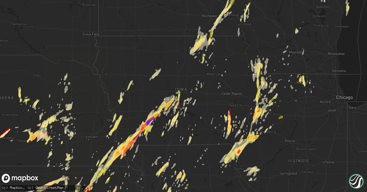
Hail Map in Iowa on May 19, 2013
Get this storm
May 19 map
$229
one time, instant access
Download today. No call, no setup
Keep the $229
Bought the map and want the full workflow? Apply the entire $229 to a subscription within 7 days. None of it is wasted.
Every map, not just this one
This buys you this map. Subscription and you get every map we run, in the markets you choose from a few cities to whole states to nationwide. Plus real-time alerts the moment a storm fires.
Contact data
Name, contact info, occupancy, even credit band for addresses in the footprint. You go from where it hit to who to call.
Become the source they trust
Unlimited branding weather history reports on demand. You already have the documented answer ready for the property owner, and you are the one who showed up with it.
Property data and RoofTrace estimates
Pull up any address you have got, its value and the exact code rules for that jurisdiction, straight from One Click Code. Then RoofTrace estimates the squares, pitch, and roof value, priced the way you price.
Storm reports in Iowa
Iowa
| Date | Description |
|---|---|
| 05/19/20136:57 PM CDT | Power lines and 18 inch diameter trees down |
| 05/19/20136:56 PM CDT | Schoolnet site |
| 05/19/20136:55 PM CDT | Delayed report |
| 05/19/20136:53 PM CDT | Roof blown off house |
| 05/19/20136:52 PM CDT | 12 inch diameter tree limbs down |
| 05/19/20136:48 PM CDT | 18 inch diameter tree limbs down on highway 44 and ashton east of dallas center |
| 05/19/20136:48 PM CDT | New machine shed with over half of roof blown off |
| 05/19/20136:48 PM CDT | Time estimated from radar. |
| 05/19/20136:43 PM CDT | House lost about three-quarters of its roof on county highway r22 just south of highway 44 |
| 05/19/20136:43 PM CDT | A local report indicates 1.25 inch wind near ADEL |
| 05/19/20136:43 PM CDT | Roof and structural damage to building. Possible tornado uncomfirmed at this time. Time estimated. |
| 05/19/20136:42 PM CDT | Trees down along division from 12th street to central park to 35th. Road blocked in spots. |
| 05/19/20136:41 PM CDT | Looking northwest off of r22 |
| 05/19/20136:41 PM CDT | A local report indicates 60 MPH wind near DAVENPORT MUNICIPAL AIR |
| 05/19/20136:40 PM CDT | A local report indicates 1.00 inch wind near 4 N FORT DODGE |
| 05/19/20136:38 PM CDT | Semi blown over |
| 05/19/20136:38 PM CDT | Pea to small marble size hail |
| 05/19/20136:34 PM CDT | Pea to quarter sized hail west side of davenport near kimberly and fairmont. |
| 05/19/20136:32 PM CDT | Several 6 to 8 inch diameter tree limbs down near the high school. Time estimated by radar |
| 05/19/20136:32 PM CDT | Also reported nickel size hail. |
| 05/19/20136:30 PM CDT | A local report indicates 1.00 inch wind near 2 SW DAVENPORT |
| 05/19/20136:30 PM CDT | Trailer park southwest side of town. One unit with roof missing. 6-8 units damaged. Multiple tree limbs down and on roofs. |
| 05/19/20136:30 PM CDT | Trees and powerlines down west of earlham. 2 to 3 polls snapped. Shed blown over with about 30 small pieces of roof spread across field. Time estimated by radar |
| 05/19/20136:30 PM CDT | Confirmed tornado on ground west of earlham |
| 05/19/20136:29 PM CDT | Pea to quarter size hail along with torrential rainfall and wind gusts over 45 mph. |
| 05/19/20136:28 PM CDT | Hail at 112th ave and us 61 in davenport...report via facebook. |
| 05/19/20136:28 PM CDT | Golfball hail about 0.5 miles west of west lake park. Relayed by nws employee. |
| 05/19/20136:24 PM CDT | Large tree limbs broken and blown 100 yd. Time estimated from radar. |
| 05/19/20136:04 PM CDT | Relayed by scott county sheriffs office |
| 05/19/20136:04 PM CDT | Relayed by the scott county sheriffs office |
| 05/19/20136:00 PM CDT | Delayed report. Baseball size hail knocked out sky lights at walmart store in northast keokuk. Golfball to baseball size hail in north end of town. Nickel to quarter si |
| 05/19/20135:50 PM CDT | Numerous 6 inch tree limbs down and hail damage to house siding and roof damage. Hail sized unknown but dents in the aluminum was quarter to half dollar sized. Time est |
| 05/19/20135:28 PM CDT | A local report indicates 1.75 inch wind near 1 WNW KEOKUK |
| 05/19/20135:25 PM CDT | A local report indicates 1.75 inch wind near S KEOKUK |
| 05/19/20135:24 PM CDT | Nickel to quarter-size hail near shenandoah. |
| 05/19/20135:20 PM CDT | Extensive roof damage to a barn and other debris in area. |
| 05/19/20135:15 PM CDT | 2 to 3 inch diameter hail. Via social media. |
| 05/19/20135:13 PM CDT | Hail completely covering the ground |
| 05/19/20135:09 PM CDT | A local report indicates 1.00 inch wind near 2 SE BURLINGTON |
| 05/19/20135:08 PM CDT | A local report indicates 1.50 inch wind near 2 SSE BURLINGTON |
| 05/19/20135:07 PM CDT | Just east of the burlington airport. |
| 05/19/20135:06 PM CDT | A local report indicates 1.00 inch wind near 2 SSE BURLINGTON |
| 05/19/20135:06 PM CDT | A local report indicates 1.00 inch wind near VILLISCA |
| 05/19/20135:05 PM CDT | Spotter forwarded pictures of golfball hail from friend in burlington. Time estimated based on time stamp on photos. |
| 05/19/20134:30 PM CDT | Mostly pea to nickle with just a few quarter size hailstones. |
| 05/19/20134:20 PM CDT | Mitchell county emergency manager reports barn fell on cattle herd...killing some of the cattle. |
| 05/19/20134:00 PM CDT | Floyd county emergency manager reports a barn is down north of nora springs...numerous large trees uprooted...and 1 large tree fell on a house. |
| 05/19/20133:33 PM CDT | A local report indicates 60 MPH wind near 3 W PACIFIC JUNCTION |
| 05/19/20133:26 PM CDT | Lots of quarter sized hail covering the ground along hwy 9. |
| 05/19/20133:14 PM CDT | A local report indicates 1.00 inch wind near CHARLES CITY |
| 05/19/20133:09 PM CDT | Shed blown across road with debris still on power lines. |
| 05/19/20132:10 PM CDT | Damage just north of highway 18 along nash ave and 260th street. Lots of 6 inch or less tree branches down and a few power poles leaning over. Damage to a couple of gra |
| 05/19/201312:10 PM CDT | Peak wind gust from the muscatine asos. |
| 05/19/201311:20 AM CDT | Power lines down between delaware and delhi and a tree down across the highway just west of manchester. Time estimated. |
| 05/19/20139:45 AM CDT | Trees down...tin blown off barns and sheds blown down. Time estimated from radar. |
| 05/19/20139:25 AM CDT | Numerous tree limbs down...3 inches or more. Some limbs were quite large. Wind gust estimated at 65 mph. |
| 05/18/201311:50 PM CDT | 60 to 70 mph. Very heavy rain. Power flashes. |
| 05/18/201311:40 PM CDT | Large tree limb down over power lines...time estimated from radar. |
| 05/18/201311:40 PM CDT | Large tree limb over power lines...time estimated from radar. |
| 05/18/201311:28 PM CDT | Sheriff department reported a roof off a pole barn. Time estimated from radar. |
| 05/18/201311:25 PM CDT | Sheriff department reported a 40 by 50 foot shed had been lifted and dropped on 180th ave. Time estimated from radar. |
| 05/18/201311:20 PM CDT | Power lines down between delaware and delhi and a tree down across the highway just west of manchester. Time estimated. Time corrected to pm. |
| 05/18/201311:15 PM CDT | Sheriff department reported a camper on top of a truck on 300th street. Time estimated from radar. |
| 05/18/201311:15 PM CDT | 2 trees down in town. |
| 05/18/201311:12 PM CDT | Delayed report. Anemometer broke at 76 mph. Large trees blown down. |
| 05/18/201311:07 PM CDT | Live power lines down on a vehicle at 114 s marshall st in burlington. |
| 05/18/201311:04 PM CDT | Delayed report. Heavy wind damage to farm outbuildings in a a sw to ne path in the atkins and shellsburg area. Reported by a cedar rapids media employee risiding in the |
| 05/18/201311:00 PM CDT | 10 inch branch with some rotting down at chestnut and mckinley and a 4 inch healthy branch down on road near 300 east cleveland in new london. Time estimated based on r |
| 05/18/201310:58 PM CDT | A local report indicates 67 MPH wind near 5 NNE CEDAR RAPIDS |
| 05/18/201310:55 PM CDT | Delayed report. Straight-line wind damage from a downburst from the county line 3.5 miles southeast of blairstown to 2.8 miles southeast of shellsburg. Mile-wide swath |
| 05/18/201310:54 PM CDT | Part of a large tree is down in yard on carter street near plainview and cedar. |
| 05/18/201310:52 PM CDT | A local report indicates 71 MPH wind near CEDAR RAPIDS MUNICIPAL |
| 05/18/201310:52 PM CDT | Several large trees uprooted. Time estimated. |
| 05/18/201310:50 PM CDT | Numerous trees down. Metal in fields from warehouse structures. |
| 05/18/201310:50 PM CDT | Trees snapped off damaging a few trailers in a trailer park...time estimated from radar. |
| 05/18/201310:50 PM CDT | Numerous trees down. Metal in fields from warehouse structures. |
| 05/18/201310:47 PM CDT | Half of town is without power. |
| 05/18/201310:40 PM CDT | Widespread wind damage across linn county occurred between 1040pm and 1115pm. Tree damage in cedar rapids. Three large road signs on i380 near wright brothers exit blow |
| 05/18/201310:31 PM CDT | Wind gusts estimated to be 65 to 70 mph. Relayed by dmx. |
| 05/18/201310:31 PM CDT | A local report indicates 60 MPH wind near S WILLIAMSBURG |
| 05/18/201310:30 PM CDT | Widspread wind damage across much of johnson county occurred between 1030 and 11 pm. A tree was blown over onto i80 near mile marker 231. Estimated to be 65 to 70 mph. |
| 05/18/201310:20 PM CDT | Widespread wind damage began around 1020 pm near north english. It continued through 1035 pm affecting millersburg...parnell...and williamsburg. |
| 05/18/201310:10 PM CDT | Trees down in waukon |
| 05/18/201310:09 PM CDT | One tree down...ten inch trunk snapped off |
| 05/18/201310:00 PM CDT | Treess down in postville |
| 05/18/201310:00 PM CDT | Widespread wind damage across the county from 10 pm to about 1020pm. Transmission lines stnapped near and east of sigourney. Buildings damaged. Lines down in northeast |
| 05/18/20139:53 PM CDT | A local report indicates 60 MPH wind near N OSKALOOSA AIRPORT |
| 05/18/20139:49 PM CDT | Tree across the road on ashland rd |
| 05/18/20139:45 PM CDT | Light pole down on ferry street |
| 05/18/20139:45 PM CDT | Correction to time. Trees down...tin blown off barns and sheds blown down. Time estimated from radar. |
| 05/18/20139:45 PM CDT | 1 power pole and tree down along county road 918. |
| 05/18/20139:44 PM CDT | Pole barn blown into road |
| 05/18/20139:38 PM CDT | Strong winds with tree damage and blew tin off the roof of a house. Heavy rain as well. |
| 05/18/20139:35 PM CDT | A downburst with winds estimated over 70 mph struck independence. The northwest sections of town sustained the most damage...with trees down...power poles snapped...and |
| 05/18/20139:35 PM CDT | A local report indicates 58 MPH wind near INDEPENDENCE AIRPORT |
| 05/18/20139:34 PM CDT | Tree branches down on power lines. |
| 05/18/20139:30 PM CDT | Many large trees were snapped off quite a distance above the ground in the southwest and northeast portions of town. Some houses had their siding ripped off and lost sh |
| 05/18/20139:26 PM CDT | A local report indicates 70 MPH wind near 1 WNW INDEPENDENCE |
| 05/18/20139:25 PM CDT | Numerous tree limbs down...3 inches or more. Some limbs were quite large. Wind gust estimated at 65 mph. |
| 05/18/20139:24 PM CDT | Tree branches down...blocking a few streets. |
| 05/18/20139:20 PM CDT | Near the hwy 20 exit on west side of independence...very heavy rainfall observed as well. |
| 05/18/20139:15 PM CDT | Numerous trees and power lines down across new hampton. Several homes have garages damaged. Other buildings in town heavily damaged. A grain elevator in fredericksburg |
| 05/18/20139:10 PM CDT | Co-op observer reported 3 inch diamter tree limbs down. Time estimated from radar. |
| 05/18/20139:05 PM CDT | Wind damage with tree blocking road. Road now cleared. |
| 05/18/20139:05 PM CDT | Awos |
| 05/18/20138:58 PM CDT | A local report indicates 64 MPH wind near 6 S CRAIG |
| 05/18/20138:54 PM CDT | Delayed report...eight inch diameter tree branch snapped at bremer ave and 8th st. Report from social media. |
| 05/18/20138:54 PM CDT | Time estimated from radar. |
| 05/18/20138:52 PM CDT | A local report indicates 60 MPH wind near PLAINFIELD |
| 05/18/20138:52 PM CDT | A local report indicates 1.00 inch wind near PLAINFIELD |
| 05/18/20138:44 PM CDT | Trees snapped off. Time estimated from radar. |
| 05/18/20138:33 PM CDT | A local report indicates 1.00 inch wind near 10 NE NEWTON |
| 05/18/20138:30 PM CDT | Trees down in town via the waterloo courier. Time estimated by radar |
| 05/18/20138:30 PM CDT | Pea to quarter size...time estimated from radar. |
| 05/18/20138:26 PM CDT | Assistant tama county em reported that grundy county dispatch has a tornado on the ground. Grundy county requested assistance from tama county. |
| 05/18/20138:20 PM CDT | Time estimated from radar. Relayed by sheriffs office. |
| 05/18/20138:18 PM CDT | Four to six inch tree brances down. Power outage. |
| 05/18/20138:15 PM CDT | Power lines down. Large limbs broken. |
| 05/18/20138:12 PM CDT | From the marshalltown asos |
| 05/18/20138:12 PM CDT | From the marshalltown asos |
| 05/18/20137:48 PM CDT | A local report indicates 1.00 inch wind near 3 NNW MINGO |
| 05/18/20137:46 PM CDT | Six inch diameter trees down. |
| 05/18/20137:27 PM CDT | A few large tree limbs...8 inches in diameter and roughly 20 foot long down. |
| 05/18/20137:27 PM CDT | Powerlines down on highway 69 east of alleman. |
| 05/18/20137:16 PM CDT | A local report indicates 1.00 inch wind near ANKENY |
| 05/18/20137:10 PM CDT | Tornado on the ground about 2 south of slater |
| 05/18/20137:10 PM CDT | A local report indicates a tornado near 1 S HUXLEY |
| 05/18/20137:08 PM CDT | Gas station canopy torn off near 36th and ankeny blvd |
| 05/18/20137:08 PM CDT | Tornado reported between slater and huxley near 538th. Street. |
| 05/18/20137:07 PM CDT | A local report indicates 75 MPH wind near ANKENY |
| 05/18/20137:06 PM CDT | Schoolnet site |
| 05/18/20137:06 PM CDT | Shingles and siding torn from some homes. |
| 05/18/20137:04 PM CDT | 10 inch diameter tree branch down in polk city |
| 05/18/20137:04 PM CDT | A local report indicates 1.00 inch wind near 5 ESE PLEASANT HILL |
| 05/18/20137:00 PM CDT | Multiple one foot diameter trees snapped. Delayed report. Time estimated |
| 05/18/20137:00 PM CDT | Schoolnet site |
| 05/18/20137:00 PM CDT | Delayed report...tree down on a power line. |
| 05/18/20137:00 PM CDT | Large trees down or snapped off around town. |
All States Impacted by Hail Map on May 19, 2013
Cities Impacted by Hail Map on May 19, 2013
- Deerfield, WI
- Davenport, IA
- Clarksville, IA
- Plainfield, IA
- Allison, IA
- Greene, IA
- Clinton, IA
- Sabula, IA
- Miles, IA
- Two Rivers, WI
- Cushing, OK
- Drumright, OK
- Media, IL
- Wamego, KS
- Belvue, KS
- Lost Nation, IA
- Wheatland, IA
- Calamus, IA
- Grand Mound, IA
- Turon, KS
- Holden, MO
- Kingsville, MO
- Deweese, NE
- Guntersville, AL
- Sparta, TN
- Quebeck, TN
- Doyle, TN
- Walling, TN
- Smithville, TN
- Spencer, TN
- Rock Island, TN
- Forestville, WI
- Algoma, WI
- Cumberland, IA
- Villisca, IA
- Corning, IA
- Carbon, IA
- Massena, IA
- Nodaway, IA
- Dexter, KS
- Reedsburg, WI
- Seymour, WI
- Hollywood, AL
- Stevenson, AL
- Fackler, AL
- Pisgah, AL
- Flat Rock, AL
- Haskell, OK
- Gladstone, IL
- Carman, IL
- Rosalia, KS
- Leon, KS
- Coin, IA
- Mindoro, WI
- Hodgenville, KY
- Sylvia, KS
- Iuka, KS
- Pratt, KS
- Byers, KS
- Grand Island, NE
- Keokuk, IA
- Burlington, IA
- Nora Springs, IA
- Couderay, WI
- Terlton, OK
- Cleveland, OK
- Oklahoma City, OK
- Downs, KS
- Tipton, KS
- Beloit, KS
- Randall, KS
- Osborne, KS
- Glen Elder, KS
- Jewell, KS
- Scottsville, KY
- Andalusia, IL
- Reynolds, IL
- Illinois City, IL
- Milan, IL
- Taylor Ridge, IL
- Leeton, MO
- Dodge City, KS
- Ensign, KS
- Riley, KS
- Bronaugh, MO
- Liberal, MO
- Osmond, NE
- Pierce, NE
- Ravenna, NE
- Williamsburg, KS
- Topeka, KS
- Medford, OK
- Caldwell, KS
- Bellevue, IA
- Delphos, KS
- Concordia, KS
- Aurora, KS
- Little Cedar, IA
- Osage, IA
- Rudd, IA
- Laverne, OK
- Cedar Point, KS
- Colwich, KS
- Norwich, KS
- Potwin, KS
- Garden Plain, KS
- Mayfield, KS
- Kingman, KS
- Burns, KS
- El Dorado, KS
- Maize, KS
- Augusta, KS
- Goddard, KS
- Clearwater, KS
- Argonia, KS
- Cottonwood Falls, KS
- Conway Springs, KS
- Peck, KS
- Viola, KS
- Wichita, KS
- Towanda, KS
- Valley Center, KS
- Matfield Green, KS
- Haysville, KS
- Whitewater, KS
- Andover, KS
- Cheney, KS
- Wellington, KS
- Kechi, KS
- Benton, KS
- Milton, KS
- Greenwich, KS
- Cassoday, KS
- Rockford, IA
- Mason City, IA
- Norman, OK
- Newcastle, OK
- Blanchard, OK
- Hutchinson, KS
- Odessa, MO
- Lone Jack, MO
- Hardin, MO
- Pleasant Hill, MO
- Henrietta, MO
- Richmond, MO
- Oak Grove, MO
- Greenwood, MO
- Mayview, MO
- Napoleon, MO
- Bates City, MO
- Wellington, MO
- Camden, MO
- Lexington, MO
- Lees Summit, MO
- Little York, IL
- Oquawka, IL
- Seaton, IL
- Collyer, KS
- Wakeeney, KS
- Oliver Springs, TN
- Briceville, TN
- Clinton, TN
- Glasgow, KY
- Eighty Eight, KY
- Hillsdale, IL
- Colona, IL
- Glenwood, IA
- Murray, NE
- McClelland, IA
- Plattsmouth, NE
- Underwood, IA
- Nehawka, NE
- Neola, IA
- Pacific Junction, IA
- Bellevue, NE
- Offutt Afb, NE
- Weeping Water, NE
- Council Bluffs, IA
- Manor, GA
- Millwood, GA
- Oakdale, TN
- Harriman, TN
- Natoma, KS
- Paradise, KS
- Waldo, KS
- Oxford, KS
- Joplin, MO
- Mulberry, KS
- Ocala, FL
- Lamar, MO
- Wakita, OK
- Manchester, OK
- Dallas Center, IA
- Elkland, MO
- Buffalo, MO
- Luther, OK
- Wellston, OK
- Arcadia, OK
- Guthrie, OK
- Meridian, OK
- Edmond, OK
- Piedmont, OK
- Coldwater, KS
- Pawhuska, OK
- Shorter, AL
- Hardaway, AL
- Arkansas City, KS
- Onalaska, WI
- Mooreland, OK
- Buffalo, OK
- Alva, OK
- Freedom, OK
- Bouton, IA
- Perry, IA
- Gresham, NE
- Utica, NE
- Lynn Center, IL
- Orion, IL
- Salem, IA
- Saint Marys, KS
- Rossville, KS
- Scottsboro, AL
- Alma, WI
- Cochrane, WI
- Mcminnville, TN
- Braman, OK
- South Haven, KS
- Guide Rock, NE
- Burr Oak, KS
- Milton, IA
- Memphis, MO
- Alexis, IL
- Gerlaw, IL
- Polo, MO
- Hamburg, IA
- Saint Charles, IA
- Indianola, IA
- Prole, IA
- New Virginia, IA
- Banks, AL
- Union Springs, AL
- Burlingame, KS
- Rockford, IL
- Dacoma, OK
- Tampa, KS
- Hope, KS
- Scales Mound, IL
- Galena, IL
- Grandview, IA
- Wapello, IA
- Letts, IA
- Columbus Junction, IA
- Mitchellville, IA
- Perry, KS
- Lecompton, KS
- Morrison, TN
- Holcomb, KS
- Garden City, KS
- Centerville, KS
- Osage City, KS
- Lebo, KS
- Lyndon, KS
- Appleton, WI
- Kaukauna, WI
- Bennington, KS
- Tescott, KS
- Hot Springs, NC
- Charles City, IA
- Edwards, MO
- Burwell, NE
- Fredonia, KS
- Virgil, KS
- Yates Center, KS
- Fall River, KS
- Toronto, KS
- Huxley, IA
- Cambridge, IA
- Clay Center, KS
- Mount Morris, IL
- Forreston, IL
- Leaf River, IL
- Haviland, KS
- Salina, KS
- Brookville, KS
- Ellinwood, KS
- Claflin, KS
- Peachtree City, GA
- Sharpsburg, GA
- Washington, IA
- Keota, IA
- Brighton, IA
- Steinauer, NE
- Brock, NE
- Elk Creek, NE
- Pawnee City, NE
- Johnson, NE
- Tecumseh, NE
- Burchard, NE
- Farmington, IA
- Wayland, MO
- Donnellson, IA
- Argyle, IA
- Silver Creek, NE
- Delia, KS
- Bridgewater, IA
- Prescott, IA
- Belvidere, NE
- Bernard, IA
- Zwingle, IA
- Dubuque, IA
- Maquoketa, IA
- Morganville, KS
- Lehigh, KS
- Canton, KS
- Moundridge, KS
- Galva, KS
- Hillsboro, KS
- Sedgwick, KS
- Montezuma, KS
- Copeland, KS
- Cimarron, KS
- Kirkwood, IL
- Biggsville, IL
- Raritan, IL
- Smithshire, IL
- Stronghurst, IL
- Emporia, KS
- Lexington, NE
- Winfield, IA
- Union Grove, AL
- Osceola, MO
- El Dorado Springs, MO
- Cumming, IA
- West Des Moines, IA
- Riceville, IA
- Prescott, KS
- Hume, MO
- Shelton, NE
- Wood River, NE
- Polk City, IA
- Holy Cross, IA
- Glen Haven, WI
- North Buena Vista, IA
- Sherrill, IA
- Cassville, WI
- Quinter, KS
- Park, KS
- Choctaw, OK
- Amber, OK
- Trion, GA
- Minneapolis, KS
- Fall Creek, WI
- Corning, KS
- Centralia, KS
- Liberty, IL
- Pleasanton, NE
- Gibbon, NE
- Elbing, KS
- Newton, KS
- Maple Hill, KS
- Silver Lake, KS
- Winston, MO
- Pattonsburg, MO
- Weatherby, MO
- Altamont, MO
- Ludowici, GA
- Nicholls, GA
- Waycross, GA
- Mcloud, OK
- Shawnee, OK
- Saint Ansgar, IA
- Plymouth, IA
- Stacyville, IA
- Rockwell, IA
- Mount Pleasant, IA
- Knob Noster, MO
- Whiteman Air Force Base, MO
- Randolph, NE
- Winnebago, IL
- Pecatonica, IL
- Garrison, IA
- Vinton, IA
- Meadow Grove, NE
- West Chester, IA
- Bradyville, TN
- Readyville, TN
- Somers, IA
- Rockwell City, IA
- Knierim, IA
- Manson, IA
- Gravity, IA
- De Soto, IA
- Blue Rapids, KS
- Rock Port, MO
- Home, KS
- Des Moines, IA
- Winterset, IA
- Auburn, NE
- Nevada, IA
- Tarkio, MO
- Riverton, IA
- Van Meter, IA
- Booneville, IA
- Waterville, KS
- Abilene, KS
- Frankfort, KS
- Marysville, KS
- Waukee, IA
- Orient, IA
- Sheldahl, IA
- Slater, IA
- Minburn, IA
- Verdon, NE
- Westboro, MO
- Clarinda, IA
- Kelley, IA
- Vermillion, KS
- Axtell, KS
- Greenfield, IA
- Ames, IA
- Chapman, KS
- Dexter, IA
- Clive, IA
- Beattie, KS
- Elkhart, IA
- Stella, NE
- Seneca, KS
- Manhattan, KS
- Urbandale, IA
- Shubert, NE
- Nemaha, NE
- Menlo, IA
- Du Bois, NE
- Shenandoah, IA
- Stuart, IA
- Westmoreland, KS
- Granger, IA
- Liberty, NE
- Adel, IA
- Olsburg, KS
- Brownville, NE
- Norwalk, IA
- Grimes, IA
- Creston, IA
- Adair, IA
- Falls City, NE
- Ankeny, IA
- Yorktown, IA
- Fairfax, MO
- Milford, KS
- Essex, IA
- Leonardville, KS
- Redfield, IA
- Baileyville, KS
- Summerfield, KS
- Bedford, IA
- Humboldt, NE
- Watson, MO
- Northboro, IA
- Farragut, IA
- Talmage, NE
- Woodward, IA
- Stanton, IA
- Madrid, IA
- Linden, IA
- Table Rock, NE
- Johnston, IA
- Nebraska City, NE
- Casey, IA
- Earlham, IA
- Alleman, IA
- Peru, NE
- Blanchard, IA
- Windsor Heights, IA
- Randolph, KS
- Anita, IA
- Wakefield, KS
- Fontanelle, IA
- Lakin, KS
- Novinger, MO
- Green Castle, MO
- Piedmont, KS
- Atlanta, KS
- Latham, KS
- Cameron, IL
- Galesburg, IL
- Osceola, IA
- Hamilton, IL
- Nauvoo, IL
- Warsaw, IL
- Alexandria, MO
- Wymore, NE
- Warrensburg, MO
- Chilhowee, MO
- Centerview, MO
- Butler, MO
- Spring Hill, KS
- Osceola, NE
- Coffeyville, KS
- Independence, KS
- Wann, OK
- S Coffeyville, OK
- Liberty, KS
- Saint Elizabeth, MO
- Eugene, MO
- Williamstown, MO
- Montrose, IA
- Carthage, IL
- Edina, MO
- Kahoka, MO
- Keithsburg, IL
- Knox City, MO
- Rutledge, MO
- Monmouth, IL
- Danville, IA
- Saint Patrick, MO
- Wyaconda, MO
- Canton, MO
- Middletown, IA
- Lewistown, MO
- West Burlington, IA
- Dallas City, IL
- La Belle, MO
- Fort Madison, IA
- Niota, IL
- Lomax, IL
- Monticello, MO
- West Point, IA
- La Harpe, IL
- Wever, IA
- Oakville, IA
- Denmark, IA
- Chattanooga, TN
- Wildwood, GA
- Lookout Mountain, GA
- Carney, OK
- Cashion, OK
- Okarche, OK
- Sabetha, KS
- Palmer, NE
- Saint Libory, NE
- Saint Paul, NE
- Dannebrog, NE
- New London, IA
- Blackwell, OK
- Alma, KS
- Allen, KS
- Black Creek, WI
- Rising Fawn, GA
- Caney, KS
- Chatsworth, GA
- Dalton, GA
- Bryant, AL
- Bridgeport, AL
- Higdon, AL
- Hebron, NE
- Bruning, NE
- Alexandria, NE
- Satanta, KS
- Ulysses, KS
- Conrad, IA
- Liscomb, IA
- Marshalltown, IA
- Hale, MO
- Eldridge, IA
- Bettendorf, IA
- Le Claire, IA
- Eddyville, NE
- Cozad, NE
- Lancaster, WI
- Potosi, WI
- Hoxie, KS
- Wolbach, NE
- Clifton, KS
- Newark, MO
- Fair Grove, MO
- Montrose, MO
- Leesburg, FL
- Newman Grove, NE
- Saint Edward, NE
- Albion, NE
- Freeport, IL
- Oregon, IL
- Harrah, OK
- Meeker, OK
- Prague, OK
- Newalla, OK
- Sparks, OK
- Graysville, TN
- Dayton, TN
- Ord, NE
- Ericson, NE
- North Loup, NE
- Scotia, NE
- Mound Valley, KS
- Edna, KS
- Rockton, IL
- Rose Creek, MN
- Austin, MN
- Brownsdale, MN
- Dexter, MN
- Lyle, MN
- Dixon, IL
- Amboy, IL
- Franklin Grove, IL
- Screven, GA
- Patterson, GA
- Woodbury, TN
- Olpe, KS
- Lorimor, IA
- Perkins, OK
- Collins, MO
- Mayetta, KS
- Eskridge, KS
- Paxico, KS
- Holton, KS
- Troy, AL
- Brundidge, AL
- Thomasville, GA
- Tryon, OK
- Agra, OK
- Crawfordsville, IA
- Wayland, IA
- Russell, IA
- Chariton, IA
- Jamestown, KS
- Chautauqua, KS
- Sedan, KS
- Peru, KS
- Cedar Vale, KS
- Sarcoxie, MO
- Stotts City, MO
- Wentworth, MO
- Newkirk, OK
- Deer Creek, OK
- Nardin, OK
- Elma, IA
- Boston, GA
- York, NE
- Peterson, MN
- Rockville, MO
- Harwood, MO
- Walker, MO
- Schell City, MO
- Readlyn, IA
- Delta, IA
- Peculiar, MO
- Harrisonville, MO
- Durango, IA
- Peosta, IA
- Platteville, WI
- Lake City, MN
- Stockholm, WI
- Burlington, OK
- Belleville, KS
- Munden, KS
- Longford, KS
- Alda, NE
- Rich Hill, MO
- Richards, MO
- Chester, OK
- Tifton, GA
- Cameron, MO
- Radcliff, KY
- Elizabethtown, KY
- Humphrey, NE
- Platte Center, NE
- Rome, GA
- Scammon, KS
- Parsons, KS
- Frontenac, KS
- West Mineral, KS
- Dearing, KS
- Copan, OK
- Columbus, KS
- Oronogo, MO
- Mindenmines, MO
- Cherryvale, KS
- Tyro, KS
- Altamont, KS
- Cherokee, KS
- McCune, KS
- Pittsburg, KS
- Oswego, KS
- Opolis, KS
- Asbury, MO
- Weir, KS
- Niotaze, KS
- Greenfield, MO
- Onaga, KS
- State Center, IA
- Le Roy, KS
- Neosho Falls, KS
- Neal, KS
- Eureka, KS
- Severy, KS
- Sperry, IA
- Yarmouth, IA
- Oak Ridge, TN
- Knoxville, TN
- Quenemo, KS
- Vassar, KS
- Harrison, TN
- Soddy Daisy, TN
- Tuskegee, AL
- Marshall, WI
- Guttenberg, IA
- Okmulgee, OK
- Okemah, OK
- Beggs, OK
- Mankato, KS
- Oneida, IL
- Wataga, IL
- Windsor, MO
- Elyria, NE
- Notasulga, AL
- Folkston, GA
- Elgin, NE
- Petersburg, NE
- Winchester, KY
- Savanna, IL
- Republic, KS
- Holmen, WI
- Galesville, WI
- Melrose, WI
- Blair, WI
- Ettrick, WI
- Taylor, WI
- Hixton, WI
- Pierceville, KS
- Bloomington, WI
- Fort Davis, AL
- East Moline, IL
- Buffalo, KY
- Louisville, AL
- Stockton, MO
- Humansville, MO
- Dixie, GA
- Stone Lake, WI
- Thomaston, GA
- Lockwood, MO
- Golden City, MO
- Jerico Springs, MO
- Hillsboro, TN
- Milton, TN
- Mount Sterling, IL
- Clayton, IL
- Versailles, IL
- Giltner, NE
- Wausa, NE
- Sauk City, WI
- Mazomanie, WI
- Epworth, IA
- Manchester, TN
- Albany, MO
- Rulo, NE
- White Cloud, KS
- Monroe, NE
- Fort Scott, KS
- Foster, MO
- Avoca, NE
- Lawrence, NE
- Glenvil, NE
- Fairfield, NE
- Altura, MN
- Saint Charles, MN
- Dover, MN
- Minnesota City, MN
- Fountain City, WI
- Rollingstone, MN
- Clermont, FL
- Miami, OK
- Pleasant Hill, IA
- Waco, NE
- Lawson, MO
- Rayville, MO
- Alta Vista, IA
- Lime Springs, IA
- Dougherty, IA
- Le Roy, MN
- Floyd, IA
- Orchard, IA
- Taopi, MN
- Chester, IA
- Adams, MN
- McIntire, IA
- Columbus, NE
- Madison, NE
- Creston, NE
- Lindsay, NE
- Everest, KS
- Robinson, KS
- Sewanee, TN
- Dakota, MN
- La Crescent, MN
- Moline, IL
- Rock Island, IL
- Neosho, MO
- Maysville, MO
- Hortense, GA
- Odum, GA
- Bristol, GA
- Surrency, GA
- Florahome, FL
- Palatka, FL
- Whiting, KS
- Mount Auburn, IA
- Central City, NE
- Fullerton, NE
- Chillicothe, MO
- Chula, MO
- Wheeling, MO
- Deer Lodge, TN
- Jamestown, TN
- Green Ridge, MO
- Hinesville, GA
- Lindenwood, IL
- Rochelle, IL
- Harvard, NE
- Clay Center, NE
- Stockton, IL
- Goose Lake, IA
- Elizabeth, IL
- Mount Carroll, IL
- Teeds Grove, IA
- Bryant, IA
- Aurora, NE
- Burden, KS
- Cambridge, KS
- Rockmart, GA
- Blue Grass, IA
- Buffalo, IA
- La Valle, WI
- Denison, IA
- Newnan, GA
- Newcomb, TN
- Pioneer, TN
- Sturgeon Bay, WI
- Howey In The Hills, FL
- Yalaha, FL
- Maple City, KS
- Adrian, MO
- Ellston, IA
- Shannon City, IA
- Tingley, IA
- Fairfield, IA
- Sunbright, TN
- Pleasanton, KS
- Mapleton, KS
- Fulton, KS
- Redfield, KS
- Elk City, KS
- Fargo, GA
- Iola, KS
- Buffalo, KS
- Piqua, KS
- Spencer, OK
- Jones, OK
- Glennville, GA
- Fort Stewart, GA
- Claxton, GA
- Deerfield, MO
- Moundville, MO
- Nevada, MO
- Mingo, IA
- Collins, IA
- Baxter, IA
- Rhodes, IA
- Concord, GA
- Williamson, GA
- Eyota, MN
- Chatfield, MN
- Montello, WI
- Pardeeville, WI
- Portage, WI
- Winona, MN
- Walnut, KS
- Saint Paul, KS
- Hepler, KS
- Uniontown, KS
- Scandia, KS
- Norway, KS
- Cairo, NE
- Trumbull, NE
- Kearney, NE
- Doniphan, NE
- Jasper, FL
- Wykoff, MN
- Spring Valley, MN
- Amorita, OK
- Dunlap, IA
- Woodbine, IA
- Archer, NE
- Grainfield, KS
- Murray, IA
- Camp Point, IL
- Aline, OK
- Odebolt, IA
- Kiron, IA
- Junction City, KS
- New Hampton, IA
- Nashua, IA
- Ionia, IA
- Jasper, MO
- Stafford, KS
- Roan Mountain, TN
- Ainsworth, IA
- Thomson, IL
- Fulton, IL
- Rock City, IL
- Orangeville, IL
- Dakota, IL
- Clarion, IA
- Belmond, IA
- Holcombe, WI
- Ladysmith, WI
- Timewell, IL
- Parker, KS
- Benedict, NE
- Molena, GA
- Meansville, GA
- Zebulon, GA
- Fairview, OK
- Waynoka, OK
- Weirsdale, FL
- Fruitland Park, FL
- Lady Lake, FL
- Astatula, FL
- Groveland, FL
- Unadilla, GA
- Elko, GA
- Whitwell, TN
- Sylvester, GA
- Elk Falls, KS
- Moline, KS
- Honey Creek, IA
- Omaha, NE
- Carter Lake, IA
- Crescent, IA
- Seneca, MO
- Goodman, MO
- Diamond, MO
- Granby, MO
- Udall, KS
- Greeley, NE
- Gallatin, MO
- Coffey, MO
- Osborn, MO
- Jameson, MO
- Stilwell, KS
- Belton, MO
- Hanover, IL
- Paden, OK
- Dunlap, TN
- Exeland, WI
- Montpelier, IA
- Walcott, IA
- New Boston, IL
- Stockton, IA
- Muscatine, IA
- Joy, IL
- Aledo, IL
- Ty Ty, GA
- Superior, NE
- Beatrice, NE
- Wilmore, KS
- Protection, KS
- Durham, KS
- South Hutchinson, KS
- Barnum, IA
- Ewing, MO
- Louisville, TN
- Farragut, TN
- Pineville, MO
- Bella Vista, AR
- Gilman City, MO
- Bethany, MO
- Glade Spring, VA
- Meadowview, VA
- Saltville, VA
- Milo, MO
- Jesup, GA
- Nahunta, GA
- Shannon, IL
- Harper, KS
- Kingsland, GA
- Chandler, OK
- Eleva, WI
- Archie, MO
- Olmstead, KY
- Allensville, KY
- Mound City, KS
- Saint Marys, IA
- Truro, IA
- Cordova, IL
- Albany, IL
- Port Byron, IL
- Erie, IL
- Meigs, GA
- Hartsfield, GA
- Altamont, TN
- Rushford, MN
- Miller, NE
- Guild, TN
- Trenton, GA
- Ottawa, KS
- Sanderson, FL
- Lascassas, TN
- Dixon, IA
- Delmar, IA
- Scranton, KS
- Adams, NE
- Pembroke, GA
- Senoia, GA
- Corbin, KY
- Kewaunee, WI
- Lanesboro, MN
- Rolla, MO
- Hampton, NE
- Winfield, KS
- Ozark, AL
- Berryton, KS
- Wellman, IA
- Sheffield, IL
- Tecumseh, KS
- Black Earth, WI
- Mount Horeb, WI
- Blue Mounds, WI
- Hazleton, IA
- Independence, IA
- Kalona, IA
- Bristow, OK
- Monticello, WI
- Argyle, WI
- Blanchardville, WI
- Rose Hill, KS
- Verona, WI
- Douglass, KS
- Rock, KS
- Tuttle, OK
- Gypsum, KS
- Grafton, NE
- Sutton, NE
- Eau Claire, WI
- Altoona, WI
- Chippewa Falls, WI
- Meadville, MO
- La Harpe, KS
- Elsmore, KS
- Moran, KS
- Ute, IA
- Dow City, IA
- Charter Oak, IA
- Ludlow, MO
- Braymer, MO
- Utica, MO
- Dawn, MO
- Girard, KS
- Reeds, MO
- Carthage, MO
- Mooresville, MO
- Garden Prairie, IL
- Mineral Point, WI
- Morrison, IL
- Inman, KS
- Shelbyville, MO
- Belvidere, IL
- Poplar Grove, IL
- Lockridge, IA
- Fairburn, GA
- Fayetteville, GA
- Union City, GA
- Tyrone, GA
- Caledonia, MN
- New Albin, IA
- Eitzen, MN
- Kidder, MO
- Clinton, MO
- Urich, MO
- Faribault, MN
- Lonsdale, MN
- Umatilla, FL
- Louisburg, KS
- Paola, KS
- Apopka, FL
- Stockport, IA
- Alta Vista, KS
- Garden City, MO
- Creighton, MO
- Northfield, MN
- Webster, MN
- Weaubleau, MO
- Kellogg, MN
- Ochlocknee, GA
- Pelham, GA
- Fremont, IA
- Ottumwa, IA
- Hedrick, IA
- Ranburne, AL
- Ridott, IL
- Boelus, NE
- Clarks, NE
- Waseca, MN
- Chester, NE
- Hubbell, NE
- Camanche, IA
- De Witt, IA
- Grundy Center, IA
- New Glarus, WI
- Carrollton, MO
- Watertown, TN
- Madison, KS
- Hamilton, KS
- Cherokee, OK
- Harper, IA
- Wyandotte, OK
- Kirkland, IL
- Clare, IL
- Sycamore, IL
- Dekalb, IL
- Fairmount, GA
- Hiawatha, KS
- Dalton, WI
- Russell, KS
- Sidney, IA
- Thayer, IA
- Shullsburg, WI
- Darlington, WI
- De Witt, MO
- Humboldt, IA
- Fort Dodge, IA
- Moorland, IA
- Clare, IA
- Howard, KS
- Longton, KS
- Homerville, GA
- Marquette, KS
- Geneseo, KS
- Ellsworth, KS
- Falun, KS
- Grenola, KS
- Council Grove, KS
- Elba, NE
- Saint Paul, VA
- Coeburn, VA
- Carleton, NE
- Gilead, NE
- Pleasantville, IA
- Runnells, IA
- Prairie City, IA
- Ackworth, IA
- Milo, IA
- Swan, IA
- Hartford, IA
- Chickamauga, GA
- Alcoa, TN
- Rockford, TN
- Grand Meadow, MN
- Racine, MN
- Bentley, KS
- Mount Hope, KS
- Andale, KS
- Liberty, TN
- Shelby, NE
- Boley, OK
- Porter, OK
- Morris, OK
- Yukon, OK
- Stroud, OK
- Chickasha, OK
- Castle, OK
- Depew, OK
- Ulysses, NE
- Marshallville, GA
- Albion, IA
- Heflin, AL
- Hardy, NE
- Byron, NE
- South Pittsburg, TN
- Carl Junction, MO
- Galena, KS
- Baylis, IL
- New Salem, IL
- Plainville, IL
- Griggsville, IL
- Chambersburg, IL
- Barry, IL
- Fennimore, WI
- Princeton, IA
- Coal Valley, IL
- Andrew, IA
- Preston, IA
- Cuba City, WI
- Long Grove, IA
- Donahue, IA
- Cascade, IA
- Spragueville, IA
- New Liberty, IA
- La Motte, IA
- Percival, IA
- Thayer, KS
- Albertville, AL
- Langston, AL
- Groveoak, AL
- Midway, AL
- Woodland, AL
- Livingston, WI
- Stitzer, WI
- Mabel, MN
- Spring Grove, MN
- Houston, MN
- Oskaloosa, IA
- Leighton, IA
- Gay, GA
- Greenville, GA
- Luthersville, GA
- Promise City, IA
- Corydon, IA
- Seymour, IA
- Charlotte, IA
- Humeston, IA
- Newton, IA
- Neodesha, KS
- Altoona, KS
- Lamont, OK
- Mulvane, KS
- Belle Plaine, KS
- Geuda Springs, KS
- Durand, IL
- Mound City, MO
- Rewey, WI
- Belmont, WI
- Hazel Green, WI
- East Dubuque, IL
- Brooks, GA
- Ohiowa, NE
- Milligan, NE
- Reading, KS
- Neosho Rapids, KS
- Peru, IA
- Marion, KS
- Gladbrook, IA
- Sherrard, IL
- Hastings, NE
- Stromsburg, NE
- Polk, NE
- Auburntown, TN
- Utica, MN
- Bessemer, MI
- Brumley, MO
- Richland, MO
- Green, KS
- Osseo, WI
- Strum, WI
- Sterling, KS
- Kent, IL
- Lena, IL
- Sequatchie, TN
- Spivey, KS
- Auburn, KS
- Harveyville, KS
- Packwood, IA
- Loves Park, IL
- Bruce, WI
- Harmony, MN
- Preston, MN
- Johnstown, NE
- Hartsburg, MO
- Chanute, KS
- Mount Vernon, MO
- Afton, OK
- Fairland, OK
- Kincaid, KS
- Derby, KS
- Blairstown, MO
- Atlanta, GA
- Palmetto, GA
- Lithia Springs, GA
- Moreland, GA
- Douglasville, GA
- Wilton, IA
- Orlando, FL
- Tina, MO
- Carbondale, KS
- Fountain, MN
- Maiden Rock, WI
- Cresco, IA
- Genoa, NE
- Larned, KS
- Battle Creek, NE
- Kenesaw, NE
- Solomon, KS
- Miltonvale, KS
- Rushville, MO
- Woodbine, KS
- White City, KS
- Phillips, NE
- Nelson, NE
- Tunnel Hill, GA
- Ringgold, GA
- Trempealeau, WI
- Iberia, MO
- New Canton, IL
- Trenton, MO
- Jamesport, MO
- Marshall, NC
- Elmdale, KS
- Skidmore, MO
- Maitland, MO
- Lancaster, MO
- Glenwood, MO
- Queen City, MO
- Princeton, WI
- Fairbury, NE
- Lenoir City, TN
- Norborne, MO
- White House, TN
- Springfield, TN
- Cross Plains, TN
- Sheldon, MO
- Beloit, WI
- Drexel, MO
- Freeman, MO
- Mishicot, WI
- Casco, WI
- Altona, IL
- Stoughton, WI
- Appleton City, MO
- Beaman, IA
- Birmingham, IA
- Climax Springs, MO
- Denver, IA
- Seligman, MO
- Washburn, MO
- Colony, KS
- Dadeville, MO
- Aldrich, MO
- Peabody, KS
- Fort Riley, KS
- Hartford, KS
- Norfolk, NE
- Grandview, MO
- Grain Valley, MO
- Bucyrus, KS
- Raymore, MO
- Cleveland, MO
- Kansas City, MO
- Overland Park, KS
- Mount Union, IA
- Emmett, KS
- Randalia, IA
- Coats, KS
- Westphalia, KS
- Hampton, TN
- Roxbury, KS
- Assaria, KS
- Allerton, IA
- Excelsior Springs, MO
- Maxwell, IA
- Morning Sun, IA
- Melrose, IA
- Chapman, NE
- Altoona, IA
- Colfax, IA
- Bondurant, IA
- West Salem, WI
- Fair Play, MO
- Bolivar, MO
- Dunnegan, MO
- Sedalia, MO
- Pikeville, TN
- Neligh, NE
- Hokah, MN
- Hamilton, MO
- Kingston, MO
- La Fayette, GA
- Adairville, KY
- Russellville, KY
- Talladega, AL
- Alpine, AL
- Pittsfield, IL
- Cedar Rapids, NE
- Jennings, OK
- Higginsville, MO
- Waverly, AL
- Plum City, WI
- Weston, MO
- Vienna, GA
- Beersheba Springs, TN
- Radisson, WI
- Ojibwa, WI
- Bluejacket, OK
- Roscoe, IL
- Medford, MN
- Denison, KS
- Crossville, TN
- Green City, MO
- Horton, KS
- Mason City, NE
- German Valley, IL
- Baileyville, IL
- Jesup, IA
- Florence, KS
- Portland, MO
- Chamois, MO
- Denton, NE
- Ira, IA
- Melbourne, IA
- Bartlesville, OK
- Lewiston, MN
- Leicester, NC
- Bertrand, NE
- Overton, NE
- McFarland, KS
- Eustis, NE
- Breckenridge, MO
- Darlington, MO
- King City, MO
- La Crosse, WI
- Princeton, MO
- Mcpherson, KS
- Section, AL
- Lincolnville, KS
- Strong City, KS
- Lawrence, KS
- Fenton, IL
- Fort Valley, GA
- Hardy, IA
- Blue Mound, KS
- Carlisle, IA
- Baxter Springs, KS
- Quapaw, OK
- Long Lane, MO
- Ogallah, KS
- Utica, KS
- Mondovi, WI
- Ostrander, MN
- Elliott, IA
- Elmo, MO
- Burlington Junction, MO
- Braddyville, IA
- Clearmont, MO
- Afton, IA
- Keosauqua, IA
- Viola, IL
- Guthrie Center, IA
- Panora, IA
- Milan, KS
- Bogard, MO
- Havensville, KS
- Coolidge, GA
- Flag Pond, TN
- Winigan, MO
- Independence, WI
- Plainview, MN
- Elmer, MO
- Kirksville, MO
- La Plata, MO
- Overbrook, KS
- Wakarusa, KS
- Admire, KS
- Springfield, GA
- Clyo, GA
- Gridley, KS
- Rose Hill, VA
- Marble Rock, IA
- Delaware, OK
- Dallas, GA
- Hiram, GA
- Powder Springs, GA
- Plainview, NE
- Wilsey, KS
- Barneveld, WI
- Hollandale, WI
- New Windsor, IL
- Bosworth, MO
- Valley Falls, KS
- Ooltewah, TN
- Sycamore, GA
- Bartlett, KS
- Greenbrier, TN
- Mediapolis, IA
- Boyceville, WI
- Colfax, WI
- Lancaster, KY
- Prophetstown, IL
- Plevna, KS
- Dewey, OK
- Rising City, NE
- Plano, IA
- Elkton, MN
- Stewartville, MN
- Tallassee, AL
- Adairsville, GA
- La Russell, MO
- Green Cove Springs, FL
- Keystone Heights, FL
- Linn, KS
- Palmer, KS
- Armuchee, GA
- Concordia, MO
- Mount Dora, FL
- Humboldt, KS
- Beaumont, KS
- Cole Camp, MO
- Stover, MO
- Jefferson City, MO
- Welch, OK
- Lovilia, IA
- Sylacauga, AL
- Jasper, TN
- Quincy, MO
- Arcola, MO
- Chase, KS
- Lyons, KS
- Alvaton, KY
- Waverly, IA
- Shell Rock, IA
- Green Bay, WI
- Suamico, WI
- Schleswig, IA
- Camp Hill, AL
- Alton, KS
- Lenapah, OK
- Havana, KS
- Ponca City, OK
- Burbank, OK
- Fairfax, OK
- Shidler, OK
- Hays, KS
- Horton, AL
- Adams, TN
- Cedar Hill, TN
- Ellis, KS
- Plainville, KS
- Little Suamico, WI
- Farlington, KS
- Benedict, KS
- Papillion, NE
- Ashburn, GA
- Saint Joseph, MO
- Henderson, NE
- Exeter, NE
- McCool Junction, NE
- Calhoun, MO
- De Leon Springs, FL
- Pierson, FL
- Pelham, TN
- Rochester, MN
- Abbyville, KS
- Partridge, KS
- Dowelltown, TN
- Marland, OK
- Taft, OK
- Mounds, OK
- Mannford, OK
- Dennis, KS
- Waldron, KS
- Herington, KS
- Sun City, KS
- St John, KS
- Silvis, IL
- Kewanee, IL
- Mineral, IL
- Annawan, IL
- Machesney Park, IL
- Triplett, MO
- Red Oak, IA
- Treynor, IA
- Deloit, IA
- Magnolia, KY
- Arcadia, WI
- Augusta, WI
- Cadott, WI
- Black River Falls, WI
- Austell, GA
- Clarkdale, GA


