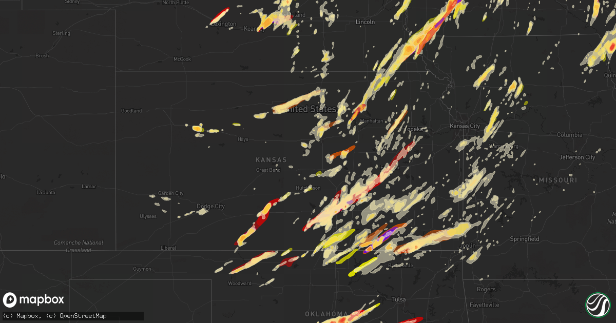
Hail Map in Kansas on May 19, 2013
Get this storm
May 19 map
$229
one time, instant access
Download today. No call, no setup
Keep the $229
Bought the map and want the full workflow? Apply the entire $229 to a subscription within 7 days. None of it is wasted.
Every map, not just this one
This buys you this map. Subscription and you get every map we run, in the markets you choose from a few cities to whole states to nationwide. Plus real-time alerts the moment a storm fires.
Contact data
Name, contact info, occupancy, even credit band for addresses in the footprint. You go from where it hit to who to call.
Become the source they trust
Unlimited branding weather history reports on demand. You already have the documented answer ready for the property owner, and you are the one who showed up with it.
Property data and RoofTrace estimates
Pull up any address you have got, its value and the exact code rules for that jurisdiction, straight from One Click Code. Then RoofTrace estimates the squares, pitch, and roof value, priced the way you price.
Storm reports in Kansas
Kansas
| Date | Description |
|---|---|
| 05/19/20136:55 PM CDT | Damage to metal roofs at a lumber yard on highway 59. |
| 05/19/20136:55 PM CDT | A local report indicates 60 MPH wind near S WHITING |
| 05/19/20136:55 PM CDT | Tree came down on vacant house |
| 05/19/20136:55 PM CDT | Trees blown down on k-16 highway about 1.5 miles west of mclouth. |
| 05/19/20136:50 PM CDT | A local report indicates 59 MPH wind near LAWRENCE AIRPORT |
| 05/19/20136:35 PM CDT | A local report indicates 1.00 inch wind near 2 WSW HUTCHINSON |
| 05/19/20136:33 PM CDT | Emergency manager reports quarter sized hail at blanchard and valley pride on the west side of south hutch. |
| 05/19/20136:32 PM CDT | A local report indicates 61 MPH wind near BILLARD AIRPORT |
| 05/19/20136:28 PM CDT | Report of a 12-inch tree limb snapped off of a healthy tree near lake shawnee. |
| 05/19/20136:26 PM CDT | A local report indicates 58 MPH wind near FORBES FIELD |
| 05/19/20136:25 PM CDT | A local report indicates 1.00 inch wind near 4 NE SYLVIA |
| 05/19/20136:25 PM CDT | A local report indicates 1.00 inch wind near 1 SW OVERBROOK |
| 05/19/20136:17 PM CDT | Wind gusts around 35 to 40 mph |
| 05/19/20136:15 PM CDT | A local report indicates 60 MPH wind near 7 N IUKA |
| 05/19/20136:12 PM CDT | A local report indicates 1.00 inch wind near 10 N PRATT |
| 05/19/20136:10 PM CDT | 3 foot diameter tree fell on home. Mobile home blown 3 to 4 feet off of its foundation. Several 1 foot diameter trees uprooted on the southeast side of burlingame. |
| 05/19/20136:03 PM CDT | A local report indicates 1.00 inch wind near OSAGE CITY |
| 05/19/20136:03 PM CDT | A local report indicates 65 MPH wind near OSAGE CITY |
| 05/19/20136:00 PM CDT | Emergency manager reports broken windows from hail driven by the wind. |
| 05/19/20135:59 PM CDT | Brief rope tornado touchdown roughly 1 north of ark city |
| 05/19/20135:59 PM CDT | A local report indicates 60 MPH wind near 1 SE ESKRIDGE |
| 05/19/20135:55 PM CDT | A 4 foot diameter tree blown over onto house at their location. |
| 05/19/20135:55 PM CDT | A local report indicates 1.00 inch wind near 12 N ELLIS |
| 05/19/20135:54 PM CDT | A local report indicates 1.00 inch wind near 2 N PRATT |
| 05/19/20135:52 PM CDT | Large tree down in courthouse square. Time estimated based on radar. |
| 05/19/20135:50 PM CDT | A local report indicates 1.00 inch wind near 4 E LONGFORD |
| 05/19/20135:49 PM CDT | A local report indicates 60 MPH wind near STROTHER FIELD AIRPORT |
| 05/19/20135:47 PM CDT | Second brief weak tornado traveled 3.7 miles before lifting just west of reading. |
| 05/19/20135:45 PM CDT | Also 70 mph winds reported. |
| 05/19/20135:45 PM CDT | Emergency manager reprots a 20 inch tree limb down and covering most of the roadway on a side street west of downtown ark city at the 100 block and north 5th street. Ti |
| 05/19/20135:43 PM CDT | Several windows broken at his house. |
| 05/19/20135:41 PM CDT | A local report indicates 1.75 inch wind near 2 NW PRATT |
| 05/19/20135:40 PM CDT | 40 to 50 mph winds also reported. |
| 05/19/20135:35 PM CDT | A local report indicates 1.00 inch wind near RANDOLPH |
| 05/19/20135:33 PM CDT | A local report indicates 1.00 inch wind near WAKEENEY |
| 05/19/20135:28 PM CDT | Small barn with minor roof damage and minor tree damage. Signs blown off highway. |
| 05/19/20135:27 PM CDT | Ef1 tornado touched down near the emporia airport. |
| 05/19/20135:25 PM CDT | A local report indicates 1.00 inch wind near 4 ESE VODA |
| 05/19/20135:25 PM CDT | Damage to a home and an out building was destroyed on old k4 highway. |
| 05/19/20135:23 PM CDT | A local report indicates 1.00 inch wind near 4 W COATS |
| 05/19/20135:22 PM CDT | A local report indicates 1.00 inch wind near ALTA VISTA |
| 05/19/20135:22 PM CDT | A local report indicates 60 MPH wind near 3 WNW LATHAM |
| 05/19/20135:10 PM CDT | A local report indicates 1.00 inch wind near BENNINGTON |
| 05/19/20135:05 PM CDT | A brief touchdown was reported by law enforcement between tampa and near ramona. This was a delayed report. Time is approximated based on radar. |
| 05/19/20135:05 PM CDT | A local report indicates 1.00 inch wind near N ROCK |
| 05/19/20135:05 PM CDT | Also reported 70 mph winds. |
| 05/19/20135:04 PM CDT | K15 and us77 |
| 05/19/20135:01 PM CDT | A local report indicates 65 MPH wind near 4 W WINFIELD |
| 05/19/20134:50 PM CDT | A local report indicates 1.00 inch wind near 4 N RANDOLPH |
| 05/19/20134:50 PM CDT | Mainly pea sized but several larger stones |
| 05/19/20134:50 PM CDT | Tennis ball size hail was reported by law enforcement 5 miles south of coldwater. |
| 05/19/20134:46 PM CDT | Spotter was 5 south of udall looking north west and observed white cone tornado |
| 05/19/20134:42 PM CDT | A local report indicates 1.75 inch wind near COLDWATER |
| 05/19/20134:40 PM CDT | A local report indicates 1.75 inch wind near 4 SSE COLDWATER |
| 05/19/20134:40 PM CDT | A rope tornado was reported 1 mile south of south haven and moving northeast by oklahoma highway troop k. |
| 05/19/20134:39 PM CDT | Delayed report of golf ball size hail just north of el dorado lake |
| 05/19/20134:36 PM CDT | Trained spotter who was 2 northeast of south haven and looking southwest towards south haven reports a brief stovepipe tornado. It was a funnel at the time of the call. |
| 05/19/20134:35 PM CDT | Elephant trunk tornado 7-8 miles east of caldwell |
| 05/19/20134:34 PM CDT | A local report indicates 1.50 inch wind near 3 ENE WAKEFIELD |
| 05/19/20134:28 PM CDT | A local report indicates 1.00 inch wind near 4 ENE WAKEFIELD |
| 05/19/20134:25 PM CDT | Fire department reports quarter sized hail 3 miles north and 2 miles east of the city of potwin. |
| 05/19/20134:21 PM CDT | Emergency manager reports an estimated 60 mph winds and pea sized hail 1 mile north of hwy 254 on highway 196. |
| 05/19/20134:20 PM CDT | A local report indicates 1.50 inch wind near 4 W ROSSVILLE |
| 05/19/20134:18 PM CDT | Spotter was 1 mile west of the butler and sedgewick county line on 45th street north. |
| 05/19/20134:17 PM CDT | A local report indicates 1.00 inch wind near 1 S PERTH |
| 05/19/20134:12 PM CDT | Trained spotter reported a tornado which went just south of his location. |
| 05/19/20134:08 PM CDT | A local report indicates 1.75 inch wind near BEL AIRE |
| 05/19/20134:06 PM CDT | Estivated 60mph winds north end of andover |
| 05/19/20134:05 PM CDT | A local report indicates 1.00 inch wind near 4 ESE PAXICO |
| 05/19/20134:01 PM CDT | A local report indicates 1.75 inch wind near 2 N BENTON |
| 05/19/20134:01 PM CDT | 5 power poles down along 135 street west and road is blocked |
| 05/19/20133:57 PM CDT | Quarter size hail at the kwch office |
| 05/19/20133:46 PM CDT | Golf ball size hail at the nws office |
| 05/19/20133:40 PM CDT | Several trees uprooted near hoover and macarther area |
| 05/19/20133:38 PM CDT | Uprooted trees and downed power lines for about a mile near 119th street west and just north of 55th street south. Unknown damage to farmsteads as well. |
| 05/19/20133:37 PM CDT | Spotter reports large cone tornado doing damage |
| 05/19/20133:31 PM CDT | A local report indicates 1.75 inch wind near 4 N CLEARWATER |
| 05/19/20133:24 PM CDT | A local report indicates 1.75 inch wind near 5 WNW CLEARWATER |
| 05/19/20133:23 PM CDT | Rope tornado touchdown approximately 30 seconds and has now lifted. |
| 05/19/20133:19 PM CDT | Brief tornado touchdown |
| 05/19/20133:18 PM CDT | A local report indicates 1.00 inch wind near 5 SW AXTELL |
| 05/19/20133:10 PM CDT | Brief tornado touchdown but has since lifted. Rotation is still seen. |
| 05/19/20132:57 PM CDT | A local report indicates 1.00 inch wind near 3 SSW BENNINGTON |
| 05/19/20132:53 PM CDT | A local report indicates 1.25 inch wind near SE NORWICH |
| 05/19/20132:50 PM CDT | A local report indicates 1.00 inch wind near 1 ENE NORWICH |
| 05/19/20132:00 PM CDT | Report provided via social media. |
| 05/19/201312:40 AM CDT | Delayed report with approximate time from radar. 4 to 8 inch branches blown down across the city of niotaze with a tree blown onto a garage. |
| 05/19/201312:08 AM CDT | Quarter to golf ball hail reported |
| 05/18/201311:50 PM CDT | Nickel size hail as well |
| 05/18/201311:30 PM CDT | Barn reported damaged. |
| 05/18/201311:30 PM CDT | One foot diameter tree reported down. |
| 05/18/201311:19 PM CDT | 60 to 70 mph winds estimated |
| 05/18/201311:15 PM CDT | Law enforcement reported large tree limbs down. |
| 05/18/201311:01 PM CDT | Trained spotter reports quarter to golf ball sized hail with heavy rain and gusty winds. Initial wind estimate was 50 mph. |
| 05/18/201310:54 PM CDT | Trained spotters reported to law enforcement that trees were down. The size was unknown at the time. Time is based on radar. |
| 05/18/201310:45 PM CDT | Law enforcement reports broken windows in homes and cars. Trees of unknown size were reported down. |
| 05/18/201310:45 PM CDT | A local report indicates 1.75 inch wind near COFFEYVILLE |
| 05/18/201310:26 PM CDT | Trained spotter estimates quarter to possibly a little bit larger sized hail. |
| 05/18/201310:21 PM CDT | Law enforcement reports power poles were knocked over. |
| 05/18/201310:15 PM CDT | Tree reported down across franklin street in fort scott. Nickel sized hail also reported one mile southeast of town. |
| 05/18/201310:12 PM CDT | Penny sized hail also reported. |
| 05/18/20138:40 PM CDT | A local report indicates 1.25 inch wind near 6 W IOLA |
| 05/18/20138:38 PM CDT | Trained spotter estimated nickel to quarter sized hail. |
| 05/18/20138:37 PM CDT | A local report indicates 1.75 inch wind near 3 ENE CEDAR VALE |
| 05/18/20138:37 PM CDT | Trained spotter estimates golf ball sized hail and 55 mph winds. |
| 05/18/20138:27 PM CDT | Storm chaser reports 3 inch hail but it was mostly penny and nickel sized. |
| 05/18/20138:24 PM CDT | A local report indicates 2.50 inch wind near 10 SW CEDAR VALE |
| 05/18/20138:23 PM CDT | Baseball sized hail was reported all over the road just across the border. |
| 05/18/20138:08 PM CDT | Near the town of talmo. |
| 05/18/20138:00 PM CDT | Tree blown over the road. |
| 05/18/20137:56 PM CDT | Also dime sized hail. |
| 05/18/20137:38 PM CDT | A local report indicates 63 MPH wind near BELOIT |
| 05/18/20137:35 PM CDT | Trained spotter reported winds estimated at up to 70 mph with dime size hail. |
| 05/18/20137:30 PM CDT | Delayed report of 18 inch diameter tree uprooted 4 miles south of glen elder and blocking the driveway. Power outage at same location. |
| 05/18/20137:25 PM CDT | Garage door blown off its track. Time est from nearby awos. |
| 05/18/20137:25 PM CDT | A local report indicates 70 MPH wind near OLATHE |
| 05/18/20137:25 PM CDT | Thunderstorm outflow in advance of approaching storm. |
| 05/18/20137:20 PM CDT | Two power poles down on 260 road 1.5 n of highway 24. Time estimated. |
| 05/18/20137:20 PM CDT | Several trees blown over roads near osawatomie |
| 05/18/20137:20 PM CDT | Numerous trees down in the city of paola |
| 05/18/20137:18 PM CDT | A local report indicates 72 MPH wind near 1 E GARDNER |
| 05/18/20137:15 PM CDT | Several large trees down |
| 05/18/20137:15 PM CDT | A local report indicates 60 MPH wind near ATCHISON |
| 05/18/20137:12 PM CDT | Wind reported as 60 plus |
| 05/18/20137:03 PM CDT | Approximately 10 inch diameter limb down in powhattan. Time estimated based on radar. |
All States Impacted by Hail Map on May 19, 2013
Cities Impacted by Hail Map on May 19, 2013
- Deerfield, WI
- Davenport, IA
- Clarksville, IA
- Plainfield, IA
- Allison, IA
- Greene, IA
- Clinton, IA
- Sabula, IA
- Miles, IA
- Two Rivers, WI
- Cushing, OK
- Drumright, OK
- Media, IL
- Wamego, KS
- Belvue, KS
- Lost Nation, IA
- Wheatland, IA
- Calamus, IA
- Grand Mound, IA
- Turon, KS
- Holden, MO
- Kingsville, MO
- Deweese, NE
- Guntersville, AL
- Sparta, TN
- Quebeck, TN
- Doyle, TN
- Walling, TN
- Smithville, TN
- Spencer, TN
- Rock Island, TN
- Forestville, WI
- Algoma, WI
- Cumberland, IA
- Villisca, IA
- Corning, IA
- Carbon, IA
- Massena, IA
- Nodaway, IA
- Dexter, KS
- Reedsburg, WI
- Seymour, WI
- Hollywood, AL
- Stevenson, AL
- Fackler, AL
- Pisgah, AL
- Flat Rock, AL
- Haskell, OK
- Gladstone, IL
- Carman, IL
- Rosalia, KS
- Leon, KS
- Coin, IA
- Mindoro, WI
- Hodgenville, KY
- Sylvia, KS
- Iuka, KS
- Pratt, KS
- Byers, KS
- Grand Island, NE
- Keokuk, IA
- Burlington, IA
- Nora Springs, IA
- Couderay, WI
- Terlton, OK
- Cleveland, OK
- Oklahoma City, OK
- Downs, KS
- Tipton, KS
- Beloit, KS
- Randall, KS
- Osborne, KS
- Glen Elder, KS
- Jewell, KS
- Scottsville, KY
- Andalusia, IL
- Reynolds, IL
- Illinois City, IL
- Milan, IL
- Taylor Ridge, IL
- Leeton, MO
- Dodge City, KS
- Ensign, KS
- Riley, KS
- Bronaugh, MO
- Liberal, MO
- Osmond, NE
- Pierce, NE
- Ravenna, NE
- Williamsburg, KS
- Topeka, KS
- Medford, OK
- Caldwell, KS
- Bellevue, IA
- Delphos, KS
- Concordia, KS
- Aurora, KS
- Little Cedar, IA
- Osage, IA
- Rudd, IA
- Laverne, OK
- Cedar Point, KS
- Colwich, KS
- Norwich, KS
- Potwin, KS
- Garden Plain, KS
- Mayfield, KS
- Kingman, KS
- Burns, KS
- El Dorado, KS
- Maize, KS
- Augusta, KS
- Goddard, KS
- Clearwater, KS
- Argonia, KS
- Cottonwood Falls, KS
- Conway Springs, KS
- Peck, KS
- Viola, KS
- Wichita, KS
- Towanda, KS
- Valley Center, KS
- Matfield Green, KS
- Haysville, KS
- Whitewater, KS
- Andover, KS
- Cheney, KS
- Wellington, KS
- Kechi, KS
- Benton, KS
- Milton, KS
- Greenwich, KS
- Cassoday, KS
- Rockford, IA
- Mason City, IA
- Norman, OK
- Newcastle, OK
- Blanchard, OK
- Hutchinson, KS
- Odessa, MO
- Lone Jack, MO
- Hardin, MO
- Pleasant Hill, MO
- Henrietta, MO
- Richmond, MO
- Oak Grove, MO
- Greenwood, MO
- Mayview, MO
- Napoleon, MO
- Bates City, MO
- Wellington, MO
- Camden, MO
- Lexington, MO
- Lees Summit, MO
- Little York, IL
- Oquawka, IL
- Seaton, IL
- Collyer, KS
- Wakeeney, KS
- Oliver Springs, TN
- Briceville, TN
- Clinton, TN
- Glasgow, KY
- Eighty Eight, KY
- Hillsdale, IL
- Colona, IL
- Glenwood, IA
- Murray, NE
- McClelland, IA
- Plattsmouth, NE
- Underwood, IA
- Nehawka, NE
- Neola, IA
- Pacific Junction, IA
- Bellevue, NE
- Offutt Afb, NE
- Weeping Water, NE
- Council Bluffs, IA
- Manor, GA
- Millwood, GA
- Oakdale, TN
- Harriman, TN
- Natoma, KS
- Paradise, KS
- Waldo, KS
- Oxford, KS
- Joplin, MO
- Mulberry, KS
- Ocala, FL
- Lamar, MO
- Wakita, OK
- Manchester, OK
- Dallas Center, IA
- Elkland, MO
- Buffalo, MO
- Luther, OK
- Wellston, OK
- Arcadia, OK
- Guthrie, OK
- Meridian, OK
- Edmond, OK
- Piedmont, OK
- Coldwater, KS
- Pawhuska, OK
- Shorter, AL
- Hardaway, AL
- Arkansas City, KS
- Onalaska, WI
- Mooreland, OK
- Buffalo, OK
- Alva, OK
- Freedom, OK
- Bouton, IA
- Perry, IA
- Gresham, NE
- Utica, NE
- Lynn Center, IL
- Orion, IL
- Salem, IA
- Saint Marys, KS
- Rossville, KS
- Scottsboro, AL
- Alma, WI
- Cochrane, WI
- Mcminnville, TN
- Braman, OK
- South Haven, KS
- Guide Rock, NE
- Burr Oak, KS
- Milton, IA
- Memphis, MO
- Alexis, IL
- Gerlaw, IL
- Polo, MO
- Hamburg, IA
- Saint Charles, IA
- Indianola, IA
- Prole, IA
- New Virginia, IA
- Banks, AL
- Union Springs, AL
- Burlingame, KS
- Rockford, IL
- Dacoma, OK
- Tampa, KS
- Hope, KS
- Scales Mound, IL
- Galena, IL
- Grandview, IA
- Wapello, IA
- Letts, IA
- Columbus Junction, IA
- Mitchellville, IA
- Perry, KS
- Lecompton, KS
- Morrison, TN
- Holcomb, KS
- Garden City, KS
- Centerville, KS
- Osage City, KS
- Lebo, KS
- Lyndon, KS
- Appleton, WI
- Kaukauna, WI
- Bennington, KS
- Tescott, KS
- Hot Springs, NC
- Charles City, IA
- Edwards, MO
- Burwell, NE
- Fredonia, KS
- Virgil, KS
- Yates Center, KS
- Fall River, KS
- Toronto, KS
- Huxley, IA
- Cambridge, IA
- Clay Center, KS
- Mount Morris, IL
- Forreston, IL
- Leaf River, IL
- Haviland, KS
- Salina, KS
- Brookville, KS
- Ellinwood, KS
- Claflin, KS
- Peachtree City, GA
- Sharpsburg, GA
- Washington, IA
- Keota, IA
- Brighton, IA
- Steinauer, NE
- Brock, NE
- Elk Creek, NE
- Pawnee City, NE
- Johnson, NE
- Tecumseh, NE
- Burchard, NE
- Farmington, IA
- Wayland, MO
- Donnellson, IA
- Argyle, IA
- Silver Creek, NE
- Delia, KS
- Bridgewater, IA
- Prescott, IA
- Belvidere, NE
- Bernard, IA
- Zwingle, IA
- Dubuque, IA
- Maquoketa, IA
- Morganville, KS
- Lehigh, KS
- Canton, KS
- Moundridge, KS
- Galva, KS
- Hillsboro, KS
- Sedgwick, KS
- Montezuma, KS
- Copeland, KS
- Cimarron, KS
- Kirkwood, IL
- Biggsville, IL
- Raritan, IL
- Smithshire, IL
- Stronghurst, IL
- Emporia, KS
- Lexington, NE
- Winfield, IA
- Union Grove, AL
- Osceola, MO
- El Dorado Springs, MO
- Cumming, IA
- West Des Moines, IA
- Riceville, IA
- Prescott, KS
- Hume, MO
- Shelton, NE
- Wood River, NE
- Polk City, IA
- Holy Cross, IA
- Glen Haven, WI
- North Buena Vista, IA
- Sherrill, IA
- Cassville, WI
- Quinter, KS
- Park, KS
- Choctaw, OK
- Amber, OK
- Trion, GA
- Minneapolis, KS
- Fall Creek, WI
- Corning, KS
- Centralia, KS
- Liberty, IL
- Pleasanton, NE
- Gibbon, NE
- Elbing, KS
- Newton, KS
- Maple Hill, KS
- Silver Lake, KS
- Winston, MO
- Pattonsburg, MO
- Weatherby, MO
- Altamont, MO
- Ludowici, GA
- Nicholls, GA
- Waycross, GA
- Mcloud, OK
- Shawnee, OK
- Saint Ansgar, IA
- Plymouth, IA
- Stacyville, IA
- Rockwell, IA
- Mount Pleasant, IA
- Knob Noster, MO
- Whiteman Air Force Base, MO
- Randolph, NE
- Winnebago, IL
- Pecatonica, IL
- Garrison, IA
- Vinton, IA
- Meadow Grove, NE
- West Chester, IA
- Bradyville, TN
- Readyville, TN
- Somers, IA
- Rockwell City, IA
- Knierim, IA
- Manson, IA
- Gravity, IA
- De Soto, IA
- Blue Rapids, KS
- Rock Port, MO
- Home, KS
- Des Moines, IA
- Winterset, IA
- Auburn, NE
- Nevada, IA
- Tarkio, MO
- Riverton, IA
- Van Meter, IA
- Booneville, IA
- Waterville, KS
- Abilene, KS
- Frankfort, KS
- Marysville, KS
- Waukee, IA
- Orient, IA
- Sheldahl, IA
- Slater, IA
- Minburn, IA
- Verdon, NE
- Westboro, MO
- Clarinda, IA
- Kelley, IA
- Vermillion, KS
- Axtell, KS
- Greenfield, IA
- Ames, IA
- Chapman, KS
- Dexter, IA
- Clive, IA
- Beattie, KS
- Elkhart, IA
- Stella, NE
- Seneca, KS
- Manhattan, KS
- Urbandale, IA
- Shubert, NE
- Nemaha, NE
- Menlo, IA
- Du Bois, NE
- Shenandoah, IA
- Stuart, IA
- Westmoreland, KS
- Granger, IA
- Liberty, NE
- Adel, IA
- Olsburg, KS
- Brownville, NE
- Norwalk, IA
- Grimes, IA
- Creston, IA
- Adair, IA
- Falls City, NE
- Ankeny, IA
- Yorktown, IA
- Fairfax, MO
- Milford, KS
- Essex, IA
- Leonardville, KS
- Redfield, IA
- Baileyville, KS
- Summerfield, KS
- Bedford, IA
- Humboldt, NE
- Watson, MO
- Northboro, IA
- Farragut, IA
- Talmage, NE
- Woodward, IA
- Stanton, IA
- Madrid, IA
- Linden, IA
- Table Rock, NE
- Johnston, IA
- Nebraska City, NE
- Casey, IA
- Earlham, IA
- Alleman, IA
- Peru, NE
- Blanchard, IA
- Windsor Heights, IA
- Randolph, KS
- Anita, IA
- Wakefield, KS
- Fontanelle, IA
- Lakin, KS
- Novinger, MO
- Green Castle, MO
- Piedmont, KS
- Atlanta, KS
- Latham, KS
- Cameron, IL
- Galesburg, IL
- Osceola, IA
- Hamilton, IL
- Nauvoo, IL
- Warsaw, IL
- Alexandria, MO
- Wymore, NE
- Warrensburg, MO
- Chilhowee, MO
- Centerview, MO
- Butler, MO
- Spring Hill, KS
- Osceola, NE
- Coffeyville, KS
- Independence, KS
- Wann, OK
- S Coffeyville, OK
- Liberty, KS
- Saint Elizabeth, MO
- Eugene, MO
- Williamstown, MO
- Montrose, IA
- Carthage, IL
- Edina, MO
- Kahoka, MO
- Keithsburg, IL
- Knox City, MO
- Rutledge, MO
- Monmouth, IL
- Danville, IA
- Saint Patrick, MO
- Wyaconda, MO
- Canton, MO
- Middletown, IA
- Lewistown, MO
- West Burlington, IA
- Dallas City, IL
- La Belle, MO
- Fort Madison, IA
- Niota, IL
- Lomax, IL
- Monticello, MO
- West Point, IA
- La Harpe, IL
- Wever, IA
- Oakville, IA
- Denmark, IA
- Chattanooga, TN
- Wildwood, GA
- Lookout Mountain, GA
- Carney, OK
- Cashion, OK
- Okarche, OK
- Sabetha, KS
- Palmer, NE
- Saint Libory, NE
- Saint Paul, NE
- Dannebrog, NE
- New London, IA
- Blackwell, OK
- Alma, KS
- Allen, KS
- Black Creek, WI
- Rising Fawn, GA
- Caney, KS
- Chatsworth, GA
- Dalton, GA
- Bryant, AL
- Bridgeport, AL
- Higdon, AL
- Hebron, NE
- Bruning, NE
- Alexandria, NE
- Satanta, KS
- Ulysses, KS
- Conrad, IA
- Liscomb, IA
- Marshalltown, IA
- Hale, MO
- Eldridge, IA
- Bettendorf, IA
- Le Claire, IA
- Eddyville, NE
- Cozad, NE
- Lancaster, WI
- Potosi, WI
- Hoxie, KS
- Wolbach, NE
- Clifton, KS
- Newark, MO
- Fair Grove, MO
- Montrose, MO
- Leesburg, FL
- Newman Grove, NE
- Saint Edward, NE
- Albion, NE
- Freeport, IL
- Oregon, IL
- Harrah, OK
- Meeker, OK
- Prague, OK
- Newalla, OK
- Sparks, OK
- Graysville, TN
- Dayton, TN
- Ord, NE
- Ericson, NE
- North Loup, NE
- Scotia, NE
- Mound Valley, KS
- Edna, KS
- Rockton, IL
- Rose Creek, MN
- Austin, MN
- Brownsdale, MN
- Dexter, MN
- Lyle, MN
- Dixon, IL
- Amboy, IL
- Franklin Grove, IL
- Screven, GA
- Patterson, GA
- Woodbury, TN
- Olpe, KS
- Lorimor, IA
- Perkins, OK
- Collins, MO
- Mayetta, KS
- Eskridge, KS
- Paxico, KS
- Holton, KS
- Troy, AL
- Brundidge, AL
- Thomasville, GA
- Tryon, OK
- Agra, OK
- Crawfordsville, IA
- Wayland, IA
- Russell, IA
- Chariton, IA
- Jamestown, KS
- Chautauqua, KS
- Sedan, KS
- Peru, KS
- Cedar Vale, KS
- Sarcoxie, MO
- Stotts City, MO
- Wentworth, MO
- Newkirk, OK
- Deer Creek, OK
- Nardin, OK
- Elma, IA
- Boston, GA
- York, NE
- Peterson, MN
- Rockville, MO
- Harwood, MO
- Walker, MO
- Schell City, MO
- Readlyn, IA
- Delta, IA
- Peculiar, MO
- Harrisonville, MO
- Durango, IA
- Peosta, IA
- Platteville, WI
- Lake City, MN
- Stockholm, WI
- Burlington, OK
- Belleville, KS
- Munden, KS
- Longford, KS
- Alda, NE
- Rich Hill, MO
- Richards, MO
- Chester, OK
- Tifton, GA
- Cameron, MO
- Radcliff, KY
- Elizabethtown, KY
- Humphrey, NE
- Platte Center, NE
- Rome, GA
- Scammon, KS
- Parsons, KS
- Frontenac, KS
- West Mineral, KS
- Dearing, KS
- Copan, OK
- Columbus, KS
- Oronogo, MO
- Mindenmines, MO
- Cherryvale, KS
- Tyro, KS
- Altamont, KS
- Cherokee, KS
- McCune, KS
- Pittsburg, KS
- Oswego, KS
- Opolis, KS
- Asbury, MO
- Weir, KS
- Niotaze, KS
- Greenfield, MO
- Onaga, KS
- State Center, IA
- Le Roy, KS
- Neosho Falls, KS
- Neal, KS
- Eureka, KS
- Severy, KS
- Sperry, IA
- Yarmouth, IA
- Oak Ridge, TN
- Knoxville, TN
- Quenemo, KS
- Vassar, KS
- Harrison, TN
- Soddy Daisy, TN
- Tuskegee, AL
- Marshall, WI
- Guttenberg, IA
- Okmulgee, OK
- Okemah, OK
- Beggs, OK
- Mankato, KS
- Oneida, IL
- Wataga, IL
- Windsor, MO
- Elyria, NE
- Notasulga, AL
- Folkston, GA
- Elgin, NE
- Petersburg, NE
- Winchester, KY
- Savanna, IL
- Republic, KS
- Holmen, WI
- Galesville, WI
- Melrose, WI
- Blair, WI
- Ettrick, WI
- Taylor, WI
- Hixton, WI
- Pierceville, KS
- Bloomington, WI
- Fort Davis, AL
- East Moline, IL
- Buffalo, KY
- Louisville, AL
- Stockton, MO
- Humansville, MO
- Dixie, GA
- Stone Lake, WI
- Thomaston, GA
- Lockwood, MO
- Golden City, MO
- Jerico Springs, MO
- Hillsboro, TN
- Milton, TN
- Mount Sterling, IL
- Clayton, IL
- Versailles, IL
- Giltner, NE
- Wausa, NE
- Sauk City, WI
- Mazomanie, WI
- Epworth, IA
- Manchester, TN
- Albany, MO
- Rulo, NE
- White Cloud, KS
- Monroe, NE
- Fort Scott, KS
- Foster, MO
- Avoca, NE
- Lawrence, NE
- Glenvil, NE
- Fairfield, NE
- Altura, MN
- Saint Charles, MN
- Dover, MN
- Minnesota City, MN
- Fountain City, WI
- Rollingstone, MN
- Clermont, FL
- Miami, OK
- Pleasant Hill, IA
- Waco, NE
- Lawson, MO
- Rayville, MO
- Alta Vista, IA
- Lime Springs, IA
- Dougherty, IA
- Le Roy, MN
- Floyd, IA
- Orchard, IA
- Taopi, MN
- Chester, IA
- Adams, MN
- McIntire, IA
- Columbus, NE
- Madison, NE
- Creston, NE
- Lindsay, NE
- Everest, KS
- Robinson, KS
- Sewanee, TN
- Dakota, MN
- La Crescent, MN
- Moline, IL
- Rock Island, IL
- Neosho, MO
- Maysville, MO
- Hortense, GA
- Odum, GA
- Bristol, GA
- Surrency, GA
- Florahome, FL
- Palatka, FL
- Whiting, KS
- Mount Auburn, IA
- Central City, NE
- Fullerton, NE
- Chillicothe, MO
- Chula, MO
- Wheeling, MO
- Deer Lodge, TN
- Jamestown, TN
- Green Ridge, MO
- Hinesville, GA
- Lindenwood, IL
- Rochelle, IL
- Harvard, NE
- Clay Center, NE
- Stockton, IL
- Goose Lake, IA
- Elizabeth, IL
- Mount Carroll, IL
- Teeds Grove, IA
- Bryant, IA
- Aurora, NE
- Burden, KS
- Cambridge, KS
- Rockmart, GA
- Blue Grass, IA
- Buffalo, IA
- La Valle, WI
- Denison, IA
- Newnan, GA
- Newcomb, TN
- Pioneer, TN
- Sturgeon Bay, WI
- Howey In The Hills, FL
- Yalaha, FL
- Maple City, KS
- Adrian, MO
- Ellston, IA
- Shannon City, IA
- Tingley, IA
- Fairfield, IA
- Sunbright, TN
- Pleasanton, KS
- Mapleton, KS
- Fulton, KS
- Redfield, KS
- Elk City, KS
- Fargo, GA
- Iola, KS
- Buffalo, KS
- Piqua, KS
- Spencer, OK
- Jones, OK
- Glennville, GA
- Fort Stewart, GA
- Claxton, GA
- Deerfield, MO
- Moundville, MO
- Nevada, MO
- Mingo, IA
- Collins, IA
- Baxter, IA
- Rhodes, IA
- Concord, GA
- Williamson, GA
- Eyota, MN
- Chatfield, MN
- Montello, WI
- Pardeeville, WI
- Portage, WI
- Winona, MN
- Walnut, KS
- Saint Paul, KS
- Hepler, KS
- Uniontown, KS
- Scandia, KS
- Norway, KS
- Cairo, NE
- Trumbull, NE
- Kearney, NE
- Doniphan, NE
- Jasper, FL
- Wykoff, MN
- Spring Valley, MN
- Amorita, OK
- Dunlap, IA
- Woodbine, IA
- Archer, NE
- Grainfield, KS
- Murray, IA
- Camp Point, IL
- Aline, OK
- Odebolt, IA
- Kiron, IA
- Junction City, KS
- New Hampton, IA
- Nashua, IA
- Ionia, IA
- Jasper, MO
- Stafford, KS
- Roan Mountain, TN
- Ainsworth, IA
- Thomson, IL
- Fulton, IL
- Rock City, IL
- Orangeville, IL
- Dakota, IL
- Clarion, IA
- Belmond, IA
- Holcombe, WI
- Ladysmith, WI
- Timewell, IL
- Parker, KS
- Benedict, NE
- Molena, GA
- Meansville, GA
- Zebulon, GA
- Fairview, OK
- Waynoka, OK
- Weirsdale, FL
- Fruitland Park, FL
- Lady Lake, FL
- Astatula, FL
- Groveland, FL
- Unadilla, GA
- Elko, GA
- Whitwell, TN
- Sylvester, GA
- Elk Falls, KS
- Moline, KS
- Honey Creek, IA
- Omaha, NE
- Carter Lake, IA
- Crescent, IA
- Seneca, MO
- Goodman, MO
- Diamond, MO
- Granby, MO
- Udall, KS
- Greeley, NE
- Gallatin, MO
- Coffey, MO
- Osborn, MO
- Jameson, MO
- Stilwell, KS
- Belton, MO
- Hanover, IL
- Paden, OK
- Dunlap, TN
- Exeland, WI
- Montpelier, IA
- Walcott, IA
- New Boston, IL
- Stockton, IA
- Muscatine, IA
- Joy, IL
- Aledo, IL
- Ty Ty, GA
- Superior, NE
- Beatrice, NE
- Wilmore, KS
- Protection, KS
- Durham, KS
- South Hutchinson, KS
- Barnum, IA
- Ewing, MO
- Louisville, TN
- Farragut, TN
- Pineville, MO
- Bella Vista, AR
- Gilman City, MO
- Bethany, MO
- Glade Spring, VA
- Meadowview, VA
- Saltville, VA
- Milo, MO
- Jesup, GA
- Nahunta, GA
- Shannon, IL
- Harper, KS
- Kingsland, GA
- Chandler, OK
- Eleva, WI
- Archie, MO
- Olmstead, KY
- Allensville, KY
- Mound City, KS
- Saint Marys, IA
- Truro, IA
- Cordova, IL
- Albany, IL
- Port Byron, IL
- Erie, IL
- Meigs, GA
- Hartsfield, GA
- Altamont, TN
- Rushford, MN
- Miller, NE
- Guild, TN
- Trenton, GA
- Ottawa, KS
- Sanderson, FL
- Lascassas, TN
- Dixon, IA
- Delmar, IA
- Scranton, KS
- Adams, NE
- Pembroke, GA
- Senoia, GA
- Corbin, KY
- Kewaunee, WI
- Lanesboro, MN
- Rolla, MO
- Hampton, NE
- Winfield, KS
- Ozark, AL
- Berryton, KS
- Wellman, IA
- Sheffield, IL
- Tecumseh, KS
- Black Earth, WI
- Mount Horeb, WI
- Blue Mounds, WI
- Hazleton, IA
- Independence, IA
- Kalona, IA
- Bristow, OK
- Monticello, WI
- Argyle, WI
- Blanchardville, WI
- Rose Hill, KS
- Verona, WI
- Douglass, KS
- Rock, KS
- Tuttle, OK
- Gypsum, KS
- Grafton, NE
- Sutton, NE
- Eau Claire, WI
- Altoona, WI
- Chippewa Falls, WI
- Meadville, MO
- La Harpe, KS
- Elsmore, KS
- Moran, KS
- Ute, IA
- Dow City, IA
- Charter Oak, IA
- Ludlow, MO
- Braymer, MO
- Utica, MO
- Dawn, MO
- Girard, KS
- Reeds, MO
- Carthage, MO
- Mooresville, MO
- Garden Prairie, IL
- Mineral Point, WI
- Morrison, IL
- Inman, KS
- Shelbyville, MO
- Belvidere, IL
- Poplar Grove, IL
- Lockridge, IA
- Fairburn, GA
- Fayetteville, GA
- Union City, GA
- Tyrone, GA
- Caledonia, MN
- New Albin, IA
- Eitzen, MN
- Kidder, MO
- Clinton, MO
- Urich, MO
- Faribault, MN
- Lonsdale, MN
- Umatilla, FL
- Louisburg, KS
- Paola, KS
- Apopka, FL
- Stockport, IA
- Alta Vista, KS
- Garden City, MO
- Creighton, MO
- Northfield, MN
- Webster, MN
- Weaubleau, MO
- Kellogg, MN
- Ochlocknee, GA
- Pelham, GA
- Fremont, IA
- Ottumwa, IA
- Hedrick, IA
- Ranburne, AL
- Ridott, IL
- Boelus, NE
- Clarks, NE
- Waseca, MN
- Chester, NE
- Hubbell, NE
- Camanche, IA
- De Witt, IA
- Grundy Center, IA
- New Glarus, WI
- Carrollton, MO
- Watertown, TN
- Madison, KS
- Hamilton, KS
- Cherokee, OK
- Harper, IA
- Wyandotte, OK
- Kirkland, IL
- Clare, IL
- Sycamore, IL
- Dekalb, IL
- Fairmount, GA
- Hiawatha, KS
- Dalton, WI
- Russell, KS
- Sidney, IA
- Thayer, IA
- Shullsburg, WI
- Darlington, WI
- De Witt, MO
- Humboldt, IA
- Fort Dodge, IA
- Moorland, IA
- Clare, IA
- Howard, KS
- Longton, KS
- Homerville, GA
- Marquette, KS
- Geneseo, KS
- Ellsworth, KS
- Falun, KS
- Grenola, KS
- Council Grove, KS
- Elba, NE
- Saint Paul, VA
- Coeburn, VA
- Carleton, NE
- Gilead, NE
- Pleasantville, IA
- Runnells, IA
- Prairie City, IA
- Ackworth, IA
- Milo, IA
- Swan, IA
- Hartford, IA
- Chickamauga, GA
- Alcoa, TN
- Rockford, TN
- Grand Meadow, MN
- Racine, MN
- Bentley, KS
- Mount Hope, KS
- Andale, KS
- Liberty, TN
- Shelby, NE
- Boley, OK
- Porter, OK
- Morris, OK
- Yukon, OK
- Stroud, OK
- Chickasha, OK
- Castle, OK
- Depew, OK
- Ulysses, NE
- Marshallville, GA
- Albion, IA
- Heflin, AL
- Hardy, NE
- Byron, NE
- South Pittsburg, TN
- Carl Junction, MO
- Galena, KS
- Baylis, IL
- New Salem, IL
- Plainville, IL
- Griggsville, IL
- Chambersburg, IL
- Barry, IL
- Fennimore, WI
- Princeton, IA
- Coal Valley, IL
- Andrew, IA
- Preston, IA
- Cuba City, WI
- Long Grove, IA
- Donahue, IA
- Cascade, IA
- Spragueville, IA
- New Liberty, IA
- La Motte, IA
- Percival, IA
- Thayer, KS
- Albertville, AL
- Langston, AL
- Groveoak, AL
- Midway, AL
- Woodland, AL
- Livingston, WI
- Stitzer, WI
- Mabel, MN
- Spring Grove, MN
- Houston, MN
- Oskaloosa, IA
- Leighton, IA
- Gay, GA
- Greenville, GA
- Luthersville, GA
- Promise City, IA
- Corydon, IA
- Seymour, IA
- Charlotte, IA
- Humeston, IA
- Newton, IA
- Neodesha, KS
- Altoona, KS
- Lamont, OK
- Mulvane, KS
- Belle Plaine, KS
- Geuda Springs, KS
- Durand, IL
- Mound City, MO
- Rewey, WI
- Belmont, WI
- Hazel Green, WI
- East Dubuque, IL
- Brooks, GA
- Ohiowa, NE
- Milligan, NE
- Reading, KS
- Neosho Rapids, KS
- Peru, IA
- Marion, KS
- Gladbrook, IA
- Sherrard, IL
- Hastings, NE
- Stromsburg, NE
- Polk, NE
- Auburntown, TN
- Utica, MN
- Bessemer, MI
- Brumley, MO
- Richland, MO
- Green, KS
- Osseo, WI
- Strum, WI
- Sterling, KS
- Kent, IL
- Lena, IL
- Sequatchie, TN
- Spivey, KS
- Auburn, KS
- Harveyville, KS
- Packwood, IA
- Loves Park, IL
- Bruce, WI
- Harmony, MN
- Preston, MN
- Johnstown, NE
- Hartsburg, MO
- Chanute, KS
- Mount Vernon, MO
- Afton, OK
- Fairland, OK
- Kincaid, KS
- Derby, KS
- Blairstown, MO
- Atlanta, GA
- Palmetto, GA
- Lithia Springs, GA
- Moreland, GA
- Douglasville, GA
- Wilton, IA
- Orlando, FL
- Tina, MO
- Carbondale, KS
- Fountain, MN
- Maiden Rock, WI
- Cresco, IA
- Genoa, NE
- Larned, KS
- Battle Creek, NE
- Kenesaw, NE
- Solomon, KS
- Miltonvale, KS
- Rushville, MO
- Woodbine, KS
- White City, KS
- Phillips, NE
- Nelson, NE
- Tunnel Hill, GA
- Ringgold, GA
- Trempealeau, WI
- Iberia, MO
- New Canton, IL
- Trenton, MO
- Jamesport, MO
- Marshall, NC
- Elmdale, KS
- Skidmore, MO
- Maitland, MO
- Lancaster, MO
- Glenwood, MO
- Queen City, MO
- Princeton, WI
- Fairbury, NE
- Lenoir City, TN
- Norborne, MO
- White House, TN
- Springfield, TN
- Cross Plains, TN
- Sheldon, MO
- Beloit, WI
- Drexel, MO
- Freeman, MO
- Mishicot, WI
- Casco, WI
- Altona, IL
- Stoughton, WI
- Appleton City, MO
- Beaman, IA
- Birmingham, IA
- Climax Springs, MO
- Denver, IA
- Seligman, MO
- Washburn, MO
- Colony, KS
- Dadeville, MO
- Aldrich, MO
- Peabody, KS
- Fort Riley, KS
- Hartford, KS
- Norfolk, NE
- Grandview, MO
- Grain Valley, MO
- Bucyrus, KS
- Raymore, MO
- Cleveland, MO
- Kansas City, MO
- Overland Park, KS
- Mount Union, IA
- Emmett, KS
- Randalia, IA
- Coats, KS
- Westphalia, KS
- Hampton, TN
- Roxbury, KS
- Assaria, KS
- Allerton, IA
- Excelsior Springs, MO
- Maxwell, IA
- Morning Sun, IA
- Melrose, IA
- Chapman, NE
- Altoona, IA
- Colfax, IA
- Bondurant, IA
- West Salem, WI
- Fair Play, MO
- Bolivar, MO
- Dunnegan, MO
- Sedalia, MO
- Pikeville, TN
- Neligh, NE
- Hokah, MN
- Hamilton, MO
- Kingston, MO
- La Fayette, GA
- Adairville, KY
- Russellville, KY
- Talladega, AL
- Alpine, AL
- Pittsfield, IL
- Cedar Rapids, NE
- Jennings, OK
- Higginsville, MO
- Waverly, AL
- Plum City, WI
- Weston, MO
- Vienna, GA
- Beersheba Springs, TN
- Radisson, WI
- Ojibwa, WI
- Bluejacket, OK
- Roscoe, IL
- Medford, MN
- Denison, KS
- Crossville, TN
- Green City, MO
- Horton, KS
- Mason City, NE
- German Valley, IL
- Baileyville, IL
- Jesup, IA
- Florence, KS
- Portland, MO
- Chamois, MO
- Denton, NE
- Ira, IA
- Melbourne, IA
- Bartlesville, OK
- Lewiston, MN
- Leicester, NC
- Bertrand, NE
- Overton, NE
- McFarland, KS
- Eustis, NE
- Breckenridge, MO
- Darlington, MO
- King City, MO
- La Crosse, WI
- Princeton, MO
- Mcpherson, KS
- Section, AL
- Lincolnville, KS
- Strong City, KS
- Lawrence, KS
- Fenton, IL
- Fort Valley, GA
- Hardy, IA
- Blue Mound, KS
- Carlisle, IA
- Baxter Springs, KS
- Quapaw, OK
- Long Lane, MO
- Ogallah, KS
- Utica, KS
- Mondovi, WI
- Ostrander, MN
- Elliott, IA
- Elmo, MO
- Burlington Junction, MO
- Braddyville, IA
- Clearmont, MO
- Afton, IA
- Keosauqua, IA
- Viola, IL
- Guthrie Center, IA
- Panora, IA
- Milan, KS
- Bogard, MO
- Havensville, KS
- Coolidge, GA
- Flag Pond, TN
- Winigan, MO
- Independence, WI
- Plainview, MN
- Elmer, MO
- Kirksville, MO
- La Plata, MO
- Overbrook, KS
- Wakarusa, KS
- Admire, KS
- Springfield, GA
- Clyo, GA
- Gridley, KS
- Rose Hill, VA
- Marble Rock, IA
- Delaware, OK
- Dallas, GA
- Hiram, GA
- Powder Springs, GA
- Plainview, NE
- Wilsey, KS
- Barneveld, WI
- Hollandale, WI
- New Windsor, IL
- Bosworth, MO
- Valley Falls, KS
- Ooltewah, TN
- Sycamore, GA
- Bartlett, KS
- Greenbrier, TN
- Mediapolis, IA
- Boyceville, WI
- Colfax, WI
- Lancaster, KY
- Prophetstown, IL
- Plevna, KS
- Dewey, OK
- Rising City, NE
- Plano, IA
- Elkton, MN
- Stewartville, MN
- Tallassee, AL
- Adairsville, GA
- La Russell, MO
- Green Cove Springs, FL
- Keystone Heights, FL
- Linn, KS
- Palmer, KS
- Armuchee, GA
- Concordia, MO
- Mount Dora, FL
- Humboldt, KS
- Beaumont, KS
- Cole Camp, MO
- Stover, MO
- Jefferson City, MO
- Welch, OK
- Lovilia, IA
- Sylacauga, AL
- Jasper, TN
- Quincy, MO
- Arcola, MO
- Chase, KS
- Lyons, KS
- Alvaton, KY
- Waverly, IA
- Shell Rock, IA
- Green Bay, WI
- Suamico, WI
- Schleswig, IA
- Camp Hill, AL
- Alton, KS
- Lenapah, OK
- Havana, KS
- Ponca City, OK
- Burbank, OK
- Fairfax, OK
- Shidler, OK
- Hays, KS
- Horton, AL
- Adams, TN
- Cedar Hill, TN
- Ellis, KS
- Plainville, KS
- Little Suamico, WI
- Farlington, KS
- Benedict, KS
- Papillion, NE
- Ashburn, GA
- Saint Joseph, MO
- Henderson, NE
- Exeter, NE
- McCool Junction, NE
- Calhoun, MO
- De Leon Springs, FL
- Pierson, FL
- Pelham, TN
- Rochester, MN
- Abbyville, KS
- Partridge, KS
- Dowelltown, TN
- Marland, OK
- Taft, OK
- Mounds, OK
- Mannford, OK
- Dennis, KS
- Waldron, KS
- Herington, KS
- Sun City, KS
- St John, KS
- Silvis, IL
- Kewanee, IL
- Mineral, IL
- Annawan, IL
- Machesney Park, IL
- Triplett, MO
- Red Oak, IA
- Treynor, IA
- Deloit, IA
- Magnolia, KY
- Arcadia, WI
- Augusta, WI
- Cadott, WI
- Black River Falls, WI
- Austell, GA
- Clarkdale, GA


