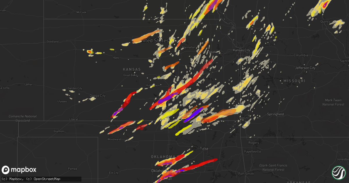
Hail Map on May 19, 2013
Get this storm
May 19 map
$229
one time, instant access
Download today. No call, no setup
Keep the $229
Bought the map and want the full workflow? Apply the entire $229 to a subscription within 7 days. None of it is wasted.
Every map, not just this one
This buys you this map. Subscription and you get every map we run, in the markets you choose from a few cities to whole states to nationwide. Plus real-time alerts the moment a storm fires.
Contact data
Name, contact info, occupancy, even credit band for addresses in the footprint. You go from where it hit to who to call.
Become the source they trust
Unlimited branding weather history reports on demand. You already have the documented answer ready for the property owner, and you are the one who showed up with it.
Property data and RoofTrace estimates
Pull up any address you have got, its value and the exact code rules for that jurisdiction, straight from One Click Code. Then RoofTrace estimates the squares, pitch, and roof value, priced the way you price.
States Impacted by Hail Map on May 19, 2013
Storm reports
Wisconsin
| Date | Description |
|---|---|
| 05/19/20136:47 PM CDT | Report of at least one power line blown down in shell lake. |
| 05/19/20136:15 PM CDT | Spotter relayed information from scanner concerning reports of power lines down between new richmond and deer park along highway 64. |
| 05/19/20136:15 PM CDT | 12 power poles down |
| 05/19/20136:15 PM CDT | Also 50 mph wind gusts. |
| 05/19/20136:07 PM CDT | Sawyer county sheriff reported several big trees down blocking portions of county highway c and state highway 27 and 70 near couderay and couderay township. |
| 05/19/20135:57 PM CDT | Power lines down in the city |
| 05/19/20135:57 PM CDT | Trees and power lines down around cochrane. |
| 05/19/20135:40 PM CDT | Three inch diameter branches down. |
| 05/19/20135:20 PM CDT | Few trees down |
| 05/19/20135:14 PM CDT | A local report indicates 58 MPH wind near EAU GALLE |
| 05/19/20133:20 PM CDT | Spotter estimated wind gust. |
| 05/19/20133:18 PM CDT | City of madison had about 10 reports of trees down. Time radar estimated. |
| 05/19/20133:03 PM CDT | One report of wires down in evansville. Time radar estimated. |
| 05/19/20132:38 PM CDT | Trees down in the adams township. Time radar estimated. |
| 05/19/20132:38 PM CDT | Power pole and trees down in the jordon township. Time radar estimated. |
| 05/19/20132:38 PM CDT | Airport awos...sustained 30 mph with gusts to 59 mph. |
| 05/19/20132:29 PM CDT | Trees down near state highway 11 and county road d. Time radar estimated. |
| 05/19/20131:55 AM CDT | One tree down in the town of marion. Time estimated based on radar. |
| 05/19/20131:31 AM CDT | Scattered reports of trees and powerlines down from northeast of oxford to south of westfield. |
| 05/19/20131:14 AM CDT | Lodim |
| 05/19/20131:00 AM CDT | 20 minutes of strong winds centered around 1 am in cross plains. Two old oak trees down along with branches from other trees. |
| 05/19/201312:56 AM CDT | Few trees down in reedsburg area. Core of storm moved northeast to area west of lake delton. |
| 05/19/201312:45 AM CDT | Trees down in spring green area. One building sustained damage. |
| 05/19/201312:40 AM CDT | Tree down on highway 130 |
| 05/19/201312:37 AM CDT | Klnr pk wind 21052/0537 |
| 05/19/201312:37 AM CDT | Lone rock asos gusted to 52 kts at 0537z. |
| 05/18/201311:50 PM CDT | A local report indicates 1.75 inch wind near 3 E POTOSI |
| 05/18/201311:46 PM CDT | Tree down in lancaster |
| 05/18/201310:45 PM CDT | Trees down in westby across hwy 14 |
| 05/18/20139:05 PM CDT | Via madison traffic on social media...highway 11 closed in orfordville at highway 213 due to trees and power lines down. Time estimated using radar. |
| 05/18/20139:05 PM CDT | Per social media madison traffic reports power outages...power flashes...and arcing wires in turtle...beloit...and afton along with other communities. Time estimated... |
| 05/18/20139:02 PM CDT | Tree went through roof of home on afton road between afton and beloit. |
| 05/18/20139:00 PM CDT | Many trees down throughout the city of beloit. Corrected time of damaging winds based on law enforcement reports. |
| 05/18/20138:50 PM CDT | Many trees down throughout the city of beloit. |
| 05/18/20137:50 PM CDT | Tree blocking one lane at pioneer road and county highway d. Time estimated based on radar. |
| 05/18/20137:05 PM CDT | Trees uprooted. Estimated 60 mph wind. Late report. |
| 05/18/20137:00 PM CDT | A local report indicates 60 MPH wind near FALL CREEK |
Florida
| Date | Description |
|---|---|
| 05/19/20134:55 PM CDT | Trained spotter estimated thunderstorm winds near 60 mph on i-75. |
| 05/19/20134:00 PM CDT | Clay electric reported multiple sites with power lines downed by trees and large limbs across clay and northern putnam county. |
| 05/19/20133:50 PM CDT | Dispatch reported a tree down on the roadway at the intersection of sungarden rd and old bostwick road. |
| 05/19/20133:45 PM CDT | Spotter reported a few trees down along river road near hurst drive outside of callahan. Time is estimated from radar. |
Alabama
| Date | Description |
|---|---|
| 05/19/20133:28 PM CDT | Quarter sized hail reported in the higdon community |
| 05/19/20133:25 PM CDT | Quarter sized hail reported in the higdon community |
Oklahoma
| Date | Description |
|---|---|
| 05/19/20136:40 PM CDT | A local report indicates 1.00 inch wind near DRUMRIGHT |
| 05/19/20136:30 PM CDT | A local report indicates 1.25 inch wind near CHOCTAW |
| 05/19/20136:28 PM CDT | 29th and douglas |
| 05/19/20136:21 PM CDT | A local report indicates 1.00 inch wind near TINKER AIR FORCE BASE |
| 05/19/20136:12 PM CDT | A local report indicates 1.50 inch wind near 2 SSE VALLEY BROOK |
| 05/19/20136:11 PM CDT | From kwtv |
| 05/19/20136:02 PM CDT | A local report indicates 1.00 inch wind near MOORE |
| 05/19/20136:01 PM CDT | From kwtv |
| 05/19/20136:00 PM CDT | A local report indicates 1.39 inch wind near NEWCASTLE |
| 05/19/20135:47 PM CDT | 36th ave nw and tecumseh rd |
| 05/19/20135:45 PM CDT | A local report indicates 1.00 inch wind near 2 SE WILL ROGERS AIRPOR |
| 05/19/20135:42 PM CDT | A local report indicates 1.50 inch wind near 2 W NORMAN |
| 05/19/20135:40 PM CDT | A local report indicates 2.00 inch wind near 4 NE NORMAN |
| 05/19/20135:40 PM CDT | A local report indicates 1.75 inch wind near NEWCASTLE |
| 05/19/20135:39 PM CDT | A local report indicates 1.75 inch wind near 1 W NEWCASTLE |
| 05/19/20135:30 PM CDT | E 12th and tecumseh |
| 05/19/20135:27 PM CDT | 36th and tecusemah |
| 05/19/20135:26 PM CDT | Near max westheimer airport. From kfor |
| 05/19/20135:25 PM CDT | A local report indicates 1.50 inch wind near 2 SW MOORE |
| 05/19/20135:13 PM CDT | Various media sources |
| 05/19/20135:10 PM CDT | County line rd and hwy 62 |
| 05/19/20135:05 PM CDT | A local report indicates 1.00 inch wind near 2 S NEWCASTLE |
| 05/19/20135:02 PM CDT | 36th nw and rock creek rd |
| 05/19/20134:55 PM CDT | A local report indicates 2.00 inch wind near 2 WSW BLANCHARD |
| 05/19/20134:53 PM CDT | From kwtv |
| 05/19/20134:51 PM CDT | A local report indicates 2.75 inch wind near 3 N LUTHER |
| 05/19/20134:37 PM CDT | A local report indicates 2.60 inch wind near 5 WNW ARCADIA |
| 05/19/20134:33 PM CDT | At e hwy 66 and post rd. From various media sources. |
| 05/19/20134:18 PM CDT | 178th and western |
| 05/19/20134:17 PM CDT | I-35 and seward |
| 05/19/20134:15 PM CDT | Utility lines downed at penn and memorial intersections |
| 05/19/20134:15 PM CDT | A local report indicates 61 MPH wind near 3 SSW FREEDOM |
| 05/19/20134:15 PM CDT | A local report indicates 1.25 inch wind near 5 W EDMOND |
| 05/19/20134:05 PM CDT | Nescatunga nr hwy 11 |
| 05/19/20134:01 PM CDT | A local report indicates 1.50 inch wind near 7 ENE PIEDMONT |
| 05/19/20133:47 PM CDT | Mcarthur and coffee creek rd |
| 05/19/20133:45 PM CDT | A local report indicates 1.00 inch wind near CHEROKEE |
| 05/18/201311:12 PM CDT | Single power pole down. |
| 05/18/201310:43 PM CDT | Few power poles down |
| 05/18/201310:20 PM CDT | A local report indicates 1.00 inch wind near 5 NW COPAN |
| 05/18/201310:01 PM CDT | Large tree over road |
| 05/18/20139:41 PM CDT | Few tree limbs down |
| 05/18/20139:38 PM CDT | Small barn blown down. Several large limbs down. |
| 05/18/20139:10 PM CDT | A local report indicates 1.00 inch wind near SHIDLER |
| 05/18/20138:30 PM CDT | A local report indicates 1.00 inch wind near BEGGS |
| 05/18/20138:20 PM CDT | Reported near nuyaka. High winds were also reported. |
| 05/18/20138:05 PM CDT | A local report indicates 59 MPH wind near 8 E NEWKIRK |
| 05/18/20137:27 PM CDT | Ef1 tornado developed north northeast of prague in lincoln county and moved northeast...dissipating west of welty in okfuskee county. Numerous trees were snapped or upr |
| 05/18/20137:24 PM CDT | A local report indicates 1.00 inch wind near 6 N PRAGUE |
| 05/18/20137:10 PM CDT | A local report indicates 61 MPH wind near 3 NNW SHAWNEE |
| 05/18/20137:08 PM CDT | A local report indicates a tornado near 2 NW PRAGUE |
Tennessee
| Date | Description |
|---|---|
| 05/19/20134:12 PM CDT | Quarter size hail was reported in milton. |
| 05/19/20133:01 PM CDT | Several trees down |
| 05/19/20132:53 PM CDT | Facebook report of 1 inch diameter hail in the faulker springs area just south of green hill. |
| 05/19/20132:34 PM CDT | Espotter report of quarter size hail just east of mcminnville. |
| 05/19/20132:04 PM CDT | Espotter report of 1 inch hail in smithville. |
| 05/19/201312:47 PM CDT | Half dollar size hail and several trees down |
| 05/19/201312:45 PM CDT | Quarter size hail reported along kingston pike near gallagher road in west knoxville. |
| 05/19/201312:45 PM CDT | Trees down on roadway in various parts of county |
| 05/19/201312:40 PM CDT | Half dollar size hail reported by spotter. |
| 05/19/201312:20 PM CDT | A local report indicates 1.00 inch wind near 7 SW KNOXVILLE |
| 05/19/201312:05 PM CDT | Wind gust of almost 70 mph measured on the west side of oak ridge. |
| 05/19/201311:30 AM CDT | Several trees down with damage to some campers...reported by emergency manager. |
| 05/19/201310:45 AM CDT | Several trees down throughout the county...reported by dispatch. |
Minnesota
| Date | Description |
|---|---|
| 05/19/20135:23 PM CDT | Structure damage. Large trees down. Pole barn down along with corn cribs. |
| 05/19/20135:23 PM CDT | Also large pieces of tin metal 6 ft long blown out |
| 05/19/20135:22 PM CDT | Power lines down in the city. One tree down in the city as well. |
| 05/19/20135:10 PM CDT | A local report indicates 58 MPH wind near 10 W RIVER FALLS |
| 05/19/20135:07 PM CDT | Lost power law enforcement receiving many call |
| 05/19/20135:00 PM CDT | Tree damage reported and some damage to roofing shingles |
| 05/19/20135:00 PM CDT | Few trees down |
| 05/19/20134:56 PM CDT | Trees down wind estimated 40 mph |
| 05/19/20134:43 PM CDT | Twitter report relayed by kttc of power out near target north and debris down on roads near the railroad tracks and assisi heights. |
| 05/19/20134:19 PM CDT | Rochester airport gusted to 6o mph at 419 pm. |
| 05/19/20134:15 PM CDT | Twitter report relayed by kttc with a report of 30 large pine trees down |
| 05/19/20133:40 PM CDT | Power poles were blown at a 45 degree angle based on estimated 60 mph straight line winds. |
| 05/18/20137:40 PM CDT | Large tree branches down. Some branches fell on vehicles and also on a deck...causing damage |
| 05/18/20137:40 PM CDT | A local report indicates 62 MPH wind near WINONA |
| 05/18/20137:30 PM CDT | A local report indicates 74 MPH wind near 1 S LEWISTON |
| 05/18/20137:28 PM CDT | A local report indicates 65 MPH wind near 1 S LEWISTON |
| 05/18/20137:25 PM CDT | Semi jacked knifed on i-90 in western winona. |
| 05/18/20137:21 PM CDT | A local report indicates 1.00 inch wind near LEWISTON |
| 05/18/20137:21 PM CDT | Trees down in the city |
Virginia
| Date | Description |
|---|---|
| 05/19/20133:58 PM CDT | Several trees down |
| 05/19/20133:30 PM CDT | Hail ranged from nickel to quarter size along rt 91 |
North Carolina
| Date | Description |
|---|---|
| 05/19/20132:10 PM CDT | A local report indicates 1.00 inch wind near 1 SW WHITEROCK |
Georgia
| Date | Description |
|---|---|
| 05/19/20136:16 PM CDT | Central dispatch reported a tree down on a house and a car as well as a tree across the road near raybon road west and oak grove road in nahunta. |
| 05/19/20136:00 PM CDT | Central dispatch reported some structural damage to outbuildings in the hortense area. |
| 05/19/20134:45 PM CDT | Spotter reported several trees down along granny crosby road between oquinn church road and nevada road in screven. Time is estimated from radar. |
| 05/19/20134:03 PM CDT | Several 2 inch diameter tree limbs snapped off by thunderstorm winds on robertson street. |
| 05/19/20134:01 PM CDT | Em reported a tree down along long street. Time estimated by radar. |
| 05/19/20133:58 PM CDT | Em reported a tree down near highway 84 and hendrix street. Time estimated by radar. |
| 05/19/20133:50 PM CDT | 911 reported a couple of trees down with passing storms but storm not severe |
| 05/19/20133:05 PM CDT | Hail up to the size of quarters on flowers road near hw-196. |
| 05/19/20133:00 PM CDT | County emergency manager reports around 10 trees down across the east and southeast portions of the county...mainly east of i-75. |
| 05/19/20132:22 PM CDT | Tree down with powerlines at 212 north dooly st. Tree down on old perry road in marshallville. Tree down on hwy 127 on marvis chapman road. |
| 05/19/20131:20 PM CDT | Several trees were reported down in butler. |
| 05/19/20131:06 PM CDT | Several trees downed in the yatesville area of eastern upson county |
| 05/19/201312:44 PM CDT | Several trees and powerlines down across roads on the north side of thomaston. A few other trees reported down in the eastern part of the county |
| 05/19/201312:26 PM CDT | Several trees reported downed in the greenville area |
| 05/19/201311:55 AM CDT | Several trees were blown down in eastern meriwether county...specifically along gay road near murray road and along highway 100 near mile marker 10. |
| 05/19/201311:45 AM CDT | Trees down on power lines and lying across the road at ellison and tyrone. |
| 05/19/201311:30 AM CDT | Several trees were reported down on highways 138 and 92. |
| 05/19/201311:30 AM CDT | Several trees and power lines were blown down in the senoia area. |
| 05/19/201311:15 AM CDT | A tree fell on a house on sunnyland drive in newnan. |
| 05/19/201311:05 AM CDT | A couple of trees were blown down in whitesburg. |
| 05/19/201311:05 AM CDT | Large hail was reported along north highway 29 near greentop road. |
| 05/19/201311:04 AM CDT | Numerous trees down and some on homes in douglas county. Pilgrims dr...windmark place...david dr...greenbrook dr...mckown rd...hidden branch rd...bomar rd...s burnt hic |
| 05/19/201311:00 AM CDT | Trees down across the county...several on power lines and homes. |
| 05/19/201310:40 AM CDT | A trained spotter reported a power line down on macland road near hiram. |
| 05/19/201310:40 AM CDT | A couple of trees and pea sized hail were reported in northern carroll county. |
| 05/19/201310:30 AM CDT | At least 15 large trees uprooted and snapped along quail ridge road. |
| 05/19/201310:24 AM CDT | Several trees down on powerlines in the rockmart and aragon area. |
| 05/18/20138:45 PM CDT | Trees on road near intersection of county roads 125 and 127. Time estimated by radar. |
Nebraska
| Date | Description |
|---|---|
| 05/19/20135:46 PM CDT | A local report indicates 1.00 inch wind near ERICSON |
| 05/19/20135:46 PM CDT | A local report indicates 1.00 inch wind near 2 W FULLERTON |
| 05/19/20135:36 PM CDT | A local report indicates 1.25 inch wind near HASTINGS |
| 05/19/20135:35 PM CDT | A local report indicates 1.25 inch wind near 14 N TAYLOR |
| 05/19/20135:28 PM CDT | Mostly penny to nickel sized |
| 05/19/20135:27 PM CDT | A local report indicates 1.00 inch wind near PLATTE CENTER |
| 05/19/20135:27 PM CDT | Nws employee reports hail up to one inch |
| 05/19/20135:20 PM CDT | A local report indicates 1.00 inch wind near 5 W BURWELL |
| 05/19/20135:20 PM CDT | Delayed report from last night...tree damage and swing set damaged in rulo area. |
| 05/19/20135:11 PM CDT | A local report indicates 1.00 inch wind near ALDA |
| 05/19/20135:05 PM CDT | A local report indicates 1.00 inch wind near 2 S ALDA |
| 05/19/20134:58 PM CDT | A local report indicates 1.00 inch wind near ALDA |
| 05/19/20134:51 PM CDT | Weak ef-1 tornado destroyed a mobile home and shed approximately 4 miles northeast of wolbach. Top wind speed estimated at 90 mph. |
| 05/19/20134:46 PM CDT | A local report indicates 1.00 inch wind near WOOD RIVER |
| 05/19/20134:45 PM CDT | Quarter size hail reported at 445 pm near ericson. |
| 05/19/20134:44 PM CDT | A local report indicates 1.75 inch wind near 4 N ST. LIBORY |
| 05/19/20134:39 PM CDT | A local report indicates 1.00 inch wind near AUBURN |
| 05/19/20134:38 PM CDT | A local report indicates 2.00 inch wind near 5 ESE AUBURN |
| 05/19/20134:36 PM CDT | A local report indicates 1.25 inch wind near 1 W NEMAHA |
| 05/19/20134:35 PM CDT | Thunderstorm winds estimated at around 70 to 80 mph destroyed one grain bin and partially flattened two others near nemaha. |
| 05/19/20134:30 PM CDT | Measured by a home weather station. |
| 05/19/20134:25 PM CDT | A local report indicates 1.00 inch wind near 5 NW WOOD RIVER |
| 05/19/20134:15 PM CDT | Along with winds estimated at 60 mph. |
| 05/19/20134:13 PM CDT | A local report indicates 1.75 inch wind near 15 N LEXINGTON |
| 05/19/20134:08 PM CDT | Quarter size hail reported near burwell. |
| 05/19/20134:07 PM CDT | Storm chaser reports golf ball size hail covering the road. |
| 05/19/20134:00 PM CDT | A local report indicates 1.00 inch wind near 2 E GIBBON |
| 05/19/20133:59 PM CDT | Storm chaser reports quarter and ping pong size hail |
| 05/19/20133:46 PM CDT | Law enforcement reports baseball size hail north of gibbon near 85th road |
| 05/19/20133:42 PM CDT | A local report indicates 1.50 inch wind near 3 SE COZAD |
| 05/19/20133:36 PM CDT | A local report indicates 1.00 inch wind near 3 S COZAD |
| 05/19/20133:35 PM CDT | Estimated 65 to 70 mph winds downing trees 1 to 11/2 foot in diameter along with pea sized hail. |
| 05/19/20133:33 PM CDT | A local report indicates 1.25 inch wind near PLATTSMOUTH |
| 05/19/20133:20 PM CDT | A local report indicates 1.00 inch wind near 6 ENE KEARNEY |
| 05/19/20133:15 PM CDT | Two 15000 bushell bins were damaged with one moved off the foundation. A 500 gallon fertilizer plastic tank was also blown over a mile away. |
| 05/19/20132:10 PM CDT | Mostly nickel but a few quarter-size. |
| 05/18/20138:58 PM CDT | A local report indicates 64 MPH wind near 6 S CRAIG |
Missouri
| Date | Description |
|---|---|
| 05/19/20135:07 PM CDT | Also wind gusts estimated to be over 50 mph from the west southwest and very heavy rain. |
| 05/19/20134:56 PM CDT | Also 60 to 70 mph winds |
| 05/19/20134:31 PM CDT | Observers comments....fast moving storm hail lasted only a brief period. |
| 05/19/20134:26 PM CDT | A local report indicates 1.75 inch wind near 2 W WESTBORO |
| 05/19/20134:08 PM CDT | A local report indicates 1.00 inch wind near ROCKPORT |
| 05/19/20134:02 PM CDT | A local report indicates 1.00 inch wind near ROCKPORT |
| 05/19/20133:43 AM CDT | Several trees and power lines down in black jack. Tree blocking the road on new hallsferry near douglas road. |
| 05/19/20133:38 AM CDT | Tree snapped off. Minor roof and gutter damage. |
| 05/19/20133:29 AM CDT | Few trees blown over reported by public on facebook. |
| 05/19/20133:15 AM CDT | Several trees down near intersection of highway 94 and highway dd near defiance. |
| 05/19/20133:07 AM CDT | Three or four power poles have been snapped off along old highway 100 and highway t. Time approximate from radar. |
| 05/19/20131:30 AM CDT | Trees down across road at 270 falling rock road. |
| 05/19/20131:20 AM CDT | Trees uprooted near granger lane. |
| 05/19/20131:06 AM CDT | Power line down. Location and time estimated. |
| 05/19/20131:05 AM CDT | Two power lines snapped off and over the road at highway 83 and 425th road. |
| 05/19/201312:48 AM CDT | Barn completely destroyed |
| 05/19/201312:39 AM CDT | Tree reported fallen on car. |
| 05/19/201312:37 AM CDT | 60 mph winds estimated along with dime sized hail. |
| 05/19/201312:32 AM CDT | 55kt gust measured at knvd |
| 05/19/201312:25 AM CDT | Emergency manager from barton county reported a cone tornado 1 mile south of highway 126 approximately 2 miles east of golden city...moving east. |
| 05/19/201312:25 AM CDT | Several outbuildings damaged. Grocery store roof damaged. Carport damaged in town with several trees down. Time of event estimated. |
| 05/19/201312:23 AM CDT | An ef-0 tornado touched down on the west side of lockwood at the golf course and city pool area. This tornado tracked east-northeast to the north end of sycamore st. A |
| 05/19/201312:12 AM CDT | Tree down across bb highway in nevada. |
| 05/19/201312:06 AM CDT | Tree reported down on house at intersection of chestnut and 118. |
| 05/19/201312:06 AM CDT | Tree reported down on house. |
| 05/19/201312:06 AM CDT | Numerous trees down...powerlines down...outbuildings destroyed...and shingle damage to homes. Time of event estimated. |
| 05/19/201312:06 AM CDT | Nws storm survey confirmed a tornado touched down briefly near the intersection of palimino and 13th street approximately 2 miles east of carthage. Numerous trees were |
| 05/19/201312:02 AM CDT | Road sign down at i-49 and fir road |
| 05/18/201311:57 PM CDT | Tree down across roadway |
| 05/18/201310:47 PM CDT | 6 large utility power poles down as well as a large tree. Time is estimated. |
| 05/18/201310:40 PM CDT | Uprooted trees with several branches down 4 to 5 inches in diameter. |
| 05/18/201310:24 PM CDT | Trees down in adrian. Time is estimated. |
| 05/18/20139:45 PM CDT | Widespread tree damage across schuyler county. Tractor trailer blown over. |
| 05/18/20139:45 PM CDT | Delayed report...half of the roof ripped off of a 150 foot long hog confinement building. Unknown number of dead hogs. |
| 05/18/20139:35 PM CDT | Roof torn off commercial building and debris on highway 6...multiple power outages in and around edina |
| 05/18/20139:30 PM CDT | Roof damage reported to a commercial building in edina. Wind gusts in the area were estimated around 50 mph. |
| 05/18/20139:13 PM CDT | 60 to 70 mph winds...powerlines down. |
| 05/18/20138:59 PM CDT | Very large tree blown down. It required a tractor to move it out of the way. |
| 05/18/20138:58 PM CDT | Roof blown off house |
| 05/18/20138:41 PM CDT | Several trees and limbs down across the city |
| 05/18/20138:30 PM CDT | A local report indicates 60 MPH wind near GALLATIN |
| 05/18/20138:25 PM CDT | 60 mph wnd gusts |
| 05/18/20138:17 PM CDT | Overhead door at cameron ems blown in. Reports of trees down in cameron. |
| 05/18/20138:16 PM CDT | Also with 45 mph winds |
| 05/18/20138:11 PM CDT | A local report indicates 1.00 inch wind near BOSWORTH |
| 05/18/20138:00 PM CDT | A local report indicates 1.75 inch wind near CHILLICOTHE |
| 05/18/20137:58 PM CDT | Power poles down...delayed report |
| 05/18/20137:58 PM CDT | A local report indicates 60 MPH wind near 5 NW GILMAN CITY |
| 05/18/20137:55 PM CDT | 4 inch diameter tree snapped |
| 05/18/20137:50 PM CDT | A local report indicates 62 MPH wind near WHITEMAN AFB |
| 05/18/20137:50 PM CDT | Trees and powerlines down at english landing park |
| 05/18/20137:45 PM CDT | 65 mph winds...roof caps blow off...street lights blown off pole...lawn furniture blown away. All occurred at 133rd and state line. |
| 05/18/20137:45 PM CDT | 65 mph winds...roof caps blow off...street lights blow off pole..lawn furniture blown away. All occurred at 133 and state line. |
| 05/18/20137:45 PM CDT | A local report indicates 60 MPH wind near 4 NW LIBERTY |
| 05/18/20137:43 PM CDT | 58 to 60 mph winds...two 30 ft.trees blown down. |
| 05/18/20137:40 PM CDT | 12 inch diameter limbs down near i435 and gregory |
| 05/18/20137:40 PM CDT | A local report indicates 60 MPH wind near GRANDVIEW |
| 05/18/20137:39 PM CDT | Numerous trees down in the weston area along and blocking 45 to buchanan county line |
| 05/18/20137:38 PM CDT | Trees and powerlines down |
| 05/18/20137:38 PM CDT | Measured 59 knot winds at kansas city downtown airport |
| 05/18/20137:38 PM CDT | A local report indicates 1.50 inch wind near 3 N WINSTON |
| 05/18/20137:37 PM CDT | A local report indicates 68 MPH wind near KANSAS CITY |
| 05/18/20137:32 PM CDT | A local report indicates 59 MPH wind near ST. JOSEPH |
| 05/18/20137:15 PM CDT | Power poles down |
| 05/18/20137:05 PM CDT | Large tree blown over...estimated 60 mph winds |
Kentucky
| Date | Description |
|---|---|
| 05/19/20134:52 PM CDT | A local report indicates 1.00 inch wind near LANCASTER |
| 05/19/20134:07 PM CDT | A local report indicates 1.00 inch wind near 2 NW HODGENVILLE |
| 05/19/20133:45 PM CDT | A local report indicates 1.75 inch wind near HODGENVILLE |
| 05/19/20133:40 PM CDT | A local report indicates 1.00 inch wind near HODGENVILLE |
Illinois
| Date | Description |
|---|---|
| 05/19/20136:50 PM CDT | Trees reported down. |
| 05/19/20136:46 PM CDT | Mostly pea size hail. |
| 05/19/20136:15 PM CDT | Trees down us 67 south of 50th street. Delayed report. |
| 05/19/20135:38 PM CDT | A local report indicates 1.00 inch wind near HAMILTON |
| 05/19/20135:21 PM CDT | Quarter sized hail and wind gusts to about 40 mph. |
| 05/19/20135:17 PM CDT | Time estimated from radar. |
| 05/19/20135:03 PM CDT | Pea to quarter size hail. |
| 05/19/20132:07 PM CDT | A local report indicates 64 MPH wind near 3 NNE STOCKTON |
| 05/19/20132:07 PM CDT | 4 inch diameter tree limb down at residence...delayed report. |
| 05/19/20131:59 PM CDT | 2 inch diameter tree limbs down. |
| 05/19/201311:43 AM CDT | A local report indicates 1.00 inch wind near 5 S MOUNT STERLING |
| 05/18/20139:17 PM CDT | Trees down. |
| 05/18/20138:59 PM CDT | Quarter to half dollar size hail 2 miles west of downtown. Time estimated. |
| 05/18/20138:58 PM CDT | Power lines down and poles leaning. Shredded branches everywhere near hononegah road. Relayed from wrex. |
| 05/18/20138:58 PM CDT | Quarter size hail near gilford and alpine. |
| 05/18/20138:47 PM CDT | Golfball size hail near trask bridge and eddy roads. |
| 05/18/20138:45 PM CDT | Several tree branches down throughout town. |
| 05/18/20138:30 PM CDT | Several 5 inch limbs down. Time approximate. 0.45 inches of rain with event. |
| 05/18/20138:20 PM CDT | Estimated gust to 60 mph. Severe dust storm reported with near zero visibility. |
| 05/18/20138:10 PM CDT | Two to three locations along highway 78 south of mount carroll with trees and power lines down. Time estimated. |
| 05/18/20138:02 PM CDT | Confirmed tornado heading nne towards chadwick. |
| 05/18/20137:55 PM CDT | A local report indicates 58 MPH wind near STERLING |
| 05/18/20137:49 PM CDT | Wind gusts estimated to be 50 to 60 mph. Also pea sized hail. |
| 05/18/20137:09 PM CDT | Trees reported down. |
| 05/18/20137:03 PM CDT | The gust occurred ahead of the storms. There was alot of blowing dust. |
| 05/18/20137:01 PM CDT | Quarter to golf ball. |
Kansas
| Date | Description |
|---|---|
| 05/19/20136:55 PM CDT | Trees blown down on k-16 highway about 1.5 miles west of mclouth. |
| 05/19/20136:55 PM CDT | Tree came down on vacant house |
| 05/19/20136:55 PM CDT | Damage to metal roofs at a lumber yard on highway 59. |
| 05/19/20136:55 PM CDT | A local report indicates 60 MPH wind near S WHITING |
| 05/19/20136:50 PM CDT | A local report indicates 59 MPH wind near LAWRENCE AIRPORT |
| 05/19/20136:35 PM CDT | A local report indicates 1.00 inch wind near 2 WSW HUTCHINSON |
| 05/19/20136:33 PM CDT | Emergency manager reports quarter sized hail at blanchard and valley pride on the west side of south hutch. |
| 05/19/20136:32 PM CDT | A local report indicates 61 MPH wind near BILLARD AIRPORT |
| 05/19/20136:28 PM CDT | Report of a 12-inch tree limb snapped off of a healthy tree near lake shawnee. |
| 05/19/20136:26 PM CDT | A local report indicates 58 MPH wind near FORBES FIELD |
| 05/19/20136:25 PM CDT | A local report indicates 1.00 inch wind near 1 SW OVERBROOK |
| 05/19/20136:25 PM CDT | A local report indicates 1.00 inch wind near 4 NE SYLVIA |
| 05/19/20136:17 PM CDT | Wind gusts around 35 to 40 mph |
| 05/19/20136:15 PM CDT | A local report indicates 60 MPH wind near 7 N IUKA |
| 05/19/20136:12 PM CDT | A local report indicates 1.00 inch wind near 10 N PRATT |
| 05/19/20136:10 PM CDT | 3 foot diameter tree fell on home. Mobile home blown 3 to 4 feet off of its foundation. Several 1 foot diameter trees uprooted on the southeast side of burlingame. |
| 05/19/20136:03 PM CDT | A local report indicates 1.00 inch wind near OSAGE CITY |
| 05/19/20136:03 PM CDT | A local report indicates 65 MPH wind near OSAGE CITY |
| 05/19/20136:00 PM CDT | Emergency manager reports broken windows from hail driven by the wind. |
| 05/19/20135:59 PM CDT | Brief rope tornado touchdown roughly 1 north of ark city |
| 05/19/20135:59 PM CDT | A local report indicates 60 MPH wind near 1 SE ESKRIDGE |
| 05/19/20135:55 PM CDT | A 4 foot diameter tree blown over onto house at their location. |
| 05/19/20135:55 PM CDT | A local report indicates 1.00 inch wind near 12 N ELLIS |
| 05/19/20135:54 PM CDT | A local report indicates 1.00 inch wind near 2 N PRATT |
| 05/19/20135:52 PM CDT | Large tree down in courthouse square. Time estimated based on radar. |
| 05/19/20135:50 PM CDT | A local report indicates 1.00 inch wind near 4 E LONGFORD |
| 05/19/20135:49 PM CDT | A local report indicates 60 MPH wind near STROTHER FIELD AIRPORT |
| 05/19/20135:47 PM CDT | Second brief weak tornado traveled 3.7 miles before lifting just west of reading. |
| 05/19/20135:45 PM CDT | Emergency manager reprots a 20 inch tree limb down and covering most of the roadway on a side street west of downtown ark city at the 100 block and north 5th street. Ti |
| 05/19/20135:45 PM CDT | Also 70 mph winds reported. |
| 05/19/20135:43 PM CDT | Several windows broken at his house. |
| 05/19/20135:41 PM CDT | A local report indicates 1.75 inch wind near 2 NW PRATT |
| 05/19/20135:40 PM CDT | 40 to 50 mph winds also reported. |
| 05/19/20135:35 PM CDT | A local report indicates 1.00 inch wind near RANDOLPH |
| 05/19/20135:33 PM CDT | A local report indicates 1.00 inch wind near WAKEENEY |
| 05/19/20135:28 PM CDT | Small barn with minor roof damage and minor tree damage. Signs blown off highway. |
| 05/19/20135:27 PM CDT | Ef1 tornado touched down near the emporia airport. |
| 05/19/20135:25 PM CDT | A local report indicates 1.00 inch wind near 4 ESE VODA |
| 05/19/20135:25 PM CDT | Damage to a home and an out building was destroyed on old k4 highway. |
| 05/19/20135:23 PM CDT | A local report indicates 1.00 inch wind near 4 W COATS |
| 05/19/20135:22 PM CDT | A local report indicates 1.00 inch wind near ALTA VISTA |
| 05/19/20135:22 PM CDT | A local report indicates 60 MPH wind near 3 WNW LATHAM |
| 05/19/20135:10 PM CDT | A local report indicates 1.00 inch wind near BENNINGTON |
| 05/19/20135:05 PM CDT | A local report indicates 1.00 inch wind near N ROCK |
| 05/19/20135:05 PM CDT | Also reported 70 mph winds. |
| 05/19/20135:05 PM CDT | A brief touchdown was reported by law enforcement between tampa and near ramona. This was a delayed report. Time is approximated based on radar. |
| 05/19/20135:04 PM CDT | K15 and us77 |
| 05/19/20135:01 PM CDT | A local report indicates 65 MPH wind near 4 W WINFIELD |
| 05/19/20134:50 PM CDT | A local report indicates 1.00 inch wind near 4 N RANDOLPH |
| 05/19/20134:50 PM CDT | Tennis ball size hail was reported by law enforcement 5 miles south of coldwater. |
| 05/19/20134:50 PM CDT | Mainly pea sized but several larger stones |
| 05/19/20134:46 PM CDT | Spotter was 5 south of udall looking north west and observed white cone tornado |
| 05/19/20134:42 PM CDT | A local report indicates 1.75 inch wind near COLDWATER |
| 05/19/20134:40 PM CDT | A rope tornado was reported 1 mile south of south haven and moving northeast by oklahoma highway troop k. |
| 05/19/20134:40 PM CDT | A local report indicates 1.75 inch wind near 4 SSE COLDWATER |
| 05/19/20134:39 PM CDT | Delayed report of golf ball size hail just north of el dorado lake |
| 05/19/20134:36 PM CDT | Trained spotter who was 2 northeast of south haven and looking southwest towards south haven reports a brief stovepipe tornado. It was a funnel at the time of the call. |
| 05/19/20134:35 PM CDT | Elephant trunk tornado 7-8 miles east of caldwell |
| 05/19/20134:34 PM CDT | A local report indicates 1.50 inch wind near 3 ENE WAKEFIELD |
| 05/19/20134:28 PM CDT | A local report indicates 1.00 inch wind near 4 ENE WAKEFIELD |
| 05/19/20134:25 PM CDT | Fire department reports quarter sized hail 3 miles north and 2 miles east of the city of potwin. |
| 05/19/20134:21 PM CDT | Emergency manager reports an estimated 60 mph winds and pea sized hail 1 mile north of hwy 254 on highway 196. |
| 05/19/20134:20 PM CDT | A local report indicates 1.50 inch wind near 4 W ROSSVILLE |
| 05/19/20134:18 PM CDT | Spotter was 1 mile west of the butler and sedgewick county line on 45th street north. |
| 05/19/20134:17 PM CDT | A local report indicates 1.00 inch wind near 1 S PERTH |
| 05/19/20134:12 PM CDT | Trained spotter reported a tornado which went just south of his location. |
| 05/19/20134:08 PM CDT | A local report indicates 1.75 inch wind near BEL AIRE |
| 05/19/20134:06 PM CDT | Estivated 60mph winds north end of andover |
| 05/19/20134:05 PM CDT | A local report indicates 1.00 inch wind near 4 ESE PAXICO |
| 05/19/20134:01 PM CDT | A local report indicates 1.75 inch wind near 2 N BENTON |
| 05/19/20134:01 PM CDT | 5 power poles down along 135 street west and road is blocked |
| 05/19/20133:57 PM CDT | Quarter size hail at the kwch office |
| 05/19/20133:46 PM CDT | Golf ball size hail at the nws office |
| 05/19/20133:40 PM CDT | Several trees uprooted near hoover and macarther area |
| 05/19/20133:38 PM CDT | Uprooted trees and downed power lines for about a mile near 119th street west and just north of 55th street south. Unknown damage to farmsteads as well. |
| 05/19/20133:37 PM CDT | Spotter reports large cone tornado doing damage |
| 05/19/20133:31 PM CDT | A local report indicates 1.75 inch wind near 4 N CLEARWATER |
| 05/19/20133:24 PM CDT | A local report indicates 1.75 inch wind near 5 WNW CLEARWATER |
| 05/19/20133:23 PM CDT | Rope tornado touchdown approximately 30 seconds and has now lifted. |
| 05/19/20133:19 PM CDT | Brief tornado touchdown |
| 05/19/20133:18 PM CDT | A local report indicates 1.00 inch wind near 5 SW AXTELL |
| 05/19/20133:10 PM CDT | Brief tornado touchdown but has since lifted. Rotation is still seen. |
| 05/19/20132:57 PM CDT | A local report indicates 1.00 inch wind near 3 SSW BENNINGTON |
| 05/19/20132:53 PM CDT | A local report indicates 1.25 inch wind near SE NORWICH |
| 05/19/20132:50 PM CDT | A local report indicates 1.00 inch wind near 1 ENE NORWICH |
| 05/19/20132:00 PM CDT | Report provided via social media. |
| 05/19/201312:40 AM CDT | Delayed report with approximate time from radar. 4 to 8 inch branches blown down across the city of niotaze with a tree blown onto a garage. |
| 05/19/201312:08 AM CDT | Quarter to golf ball hail reported |
| 05/18/201311:50 PM CDT | Nickel size hail as well |
| 05/18/201311:30 PM CDT | Barn reported damaged. |
| 05/18/201311:30 PM CDT | One foot diameter tree reported down. |
| 05/18/201311:19 PM CDT | 60 to 70 mph winds estimated |
| 05/18/201311:15 PM CDT | Law enforcement reported large tree limbs down. |
| 05/18/201311:01 PM CDT | Trained spotter reports quarter to golf ball sized hail with heavy rain and gusty winds. Initial wind estimate was 50 mph. |
| 05/18/201310:54 PM CDT | Trained spotters reported to law enforcement that trees were down. The size was unknown at the time. Time is based on radar. |
| 05/18/201310:45 PM CDT | Law enforcement reports broken windows in homes and cars. Trees of unknown size were reported down. |
| 05/18/201310:45 PM CDT | A local report indicates 1.75 inch wind near COFFEYVILLE |
| 05/18/201310:26 PM CDT | Trained spotter estimates quarter to possibly a little bit larger sized hail. |
| 05/18/201310:21 PM CDT | Law enforcement reports power poles were knocked over. |
| 05/18/201310:15 PM CDT | Tree reported down across franklin street in fort scott. Nickel sized hail also reported one mile southeast of town. |
| 05/18/201310:12 PM CDT | Penny sized hail also reported. |
| 05/18/20138:40 PM CDT | A local report indicates 1.25 inch wind near 6 W IOLA |
| 05/18/20138:38 PM CDT | Trained spotter estimated nickel to quarter sized hail. |
| 05/18/20138:37 PM CDT | Trained spotter estimates golf ball sized hail and 55 mph winds. |
| 05/18/20138:37 PM CDT | A local report indicates 1.75 inch wind near 3 ENE CEDAR VALE |
| 05/18/20138:27 PM CDT | Storm chaser reports 3 inch hail but it was mostly penny and nickel sized. |
| 05/18/20138:24 PM CDT | A local report indicates 2.50 inch wind near 10 SW CEDAR VALE |
| 05/18/20138:23 PM CDT | Baseball sized hail was reported all over the road just across the border. |
| 05/18/20138:08 PM CDT | Near the town of talmo. |
| 05/18/20138:00 PM CDT | Tree blown over the road. |
| 05/18/20137:56 PM CDT | Also dime sized hail. |
| 05/18/20137:38 PM CDT | A local report indicates 63 MPH wind near BELOIT |
| 05/18/20137:35 PM CDT | Trained spotter reported winds estimated at up to 70 mph with dime size hail. |
| 05/18/20137:30 PM CDT | Delayed report of 18 inch diameter tree uprooted 4 miles south of glen elder and blocking the driveway. Power outage at same location. |
| 05/18/20137:25 PM CDT | Thunderstorm outflow in advance of approaching storm. |
| 05/18/20137:25 PM CDT | A local report indicates 70 MPH wind near OLATHE |
| 05/18/20137:25 PM CDT | Garage door blown off its track. Time est from nearby awos. |
| 05/18/20137:20 PM CDT | Numerous trees down in the city of paola |
| 05/18/20137:20 PM CDT | Two power poles down on 260 road 1.5 n of highway 24. Time estimated. |
| 05/18/20137:20 PM CDT | Several trees blown over roads near osawatomie |
| 05/18/20137:18 PM CDT | A local report indicates 72 MPH wind near 1 E GARDNER |
| 05/18/20137:15 PM CDT | A local report indicates 60 MPH wind near ATCHISON |
| 05/18/20137:15 PM CDT | Several large trees down |
| 05/18/20137:12 PM CDT | Wind reported as 60 plus |
| 05/18/20137:03 PM CDT | Approximately 10 inch diameter limb down in powhattan. Time estimated based on radar. |
Iowa
| Date | Description |
|---|---|
| 05/19/20136:57 PM CDT | Power lines and 18 inch diameter trees down |
| 05/19/20136:56 PM CDT | Schoolnet site |
| 05/19/20136:55 PM CDT | Delayed report |
| 05/19/20136:53 PM CDT | Roof blown off house |
| 05/19/20136:52 PM CDT | 12 inch diameter tree limbs down |
| 05/19/20136:48 PM CDT | New machine shed with over half of roof blown off |
| 05/19/20136:48 PM CDT | 18 inch diameter tree limbs down on highway 44 and ashton east of dallas center |
| 05/19/20136:48 PM CDT | Time estimated from radar. |
| 05/19/20136:43 PM CDT | A local report indicates 1.25 inch wind near ADEL |
| 05/19/20136:43 PM CDT | House lost about three-quarters of its roof on county highway r22 just south of highway 44 |
| 05/19/20136:43 PM CDT | Roof and structural damage to building. Possible tornado uncomfirmed at this time. Time estimated. |
| 05/19/20136:42 PM CDT | Trees down along division from 12th street to central park to 35th. Road blocked in spots. |
| 05/19/20136:41 PM CDT | A local report indicates 60 MPH wind near DAVENPORT MUNICIPAL AIR |
| 05/19/20136:41 PM CDT | Looking northwest off of r22 |
| 05/19/20136:40 PM CDT | A local report indicates 1.00 inch wind near 4 N FORT DODGE |
| 05/19/20136:38 PM CDT | Semi blown over |
| 05/19/20136:38 PM CDT | Pea to small marble size hail |
| 05/19/20136:34 PM CDT | Pea to quarter sized hail west side of davenport near kimberly and fairmont. |
| 05/19/20136:32 PM CDT | Several 6 to 8 inch diameter tree limbs down near the high school. Time estimated by radar |
| 05/19/20136:32 PM CDT | Also reported nickel size hail. |
| 05/19/20136:30 PM CDT | Trailer park southwest side of town. One unit with roof missing. 6-8 units damaged. Multiple tree limbs down and on roofs. |
| 05/19/20136:30 PM CDT | Trees and powerlines down west of earlham. 2 to 3 polls snapped. Shed blown over with about 30 small pieces of roof spread across field. Time estimated by radar |
| 05/19/20136:30 PM CDT | Confirmed tornado on ground west of earlham |
| 05/19/20136:30 PM CDT | A local report indicates 1.00 inch wind near 2 SW DAVENPORT |
| 05/19/20136:29 PM CDT | Pea to quarter size hail along with torrential rainfall and wind gusts over 45 mph. |
| 05/19/20136:28 PM CDT | Golfball hail about 0.5 miles west of west lake park. Relayed by nws employee. |
| 05/19/20136:28 PM CDT | Hail at 112th ave and us 61 in davenport...report via facebook. |
| 05/19/20136:24 PM CDT | Large tree limbs broken and blown 100 yd. Time estimated from radar. |
| 05/19/20136:04 PM CDT | Relayed by scott county sheriffs office |
| 05/19/20136:04 PM CDT | Relayed by the scott county sheriffs office |
| 05/19/20136:00 PM CDT | Delayed report. Baseball size hail knocked out sky lights at walmart store in northast keokuk. Golfball to baseball size hail in north end of town. Nickel to quarter si |
| 05/19/20135:50 PM CDT | Numerous 6 inch tree limbs down and hail damage to house siding and roof damage. Hail sized unknown but dents in the aluminum was quarter to half dollar sized. Time est |
| 05/19/20135:28 PM CDT | A local report indicates 1.75 inch wind near 1 WNW KEOKUK |
| 05/19/20135:25 PM CDT | A local report indicates 1.75 inch wind near S KEOKUK |
| 05/19/20135:24 PM CDT | Nickel to quarter-size hail near shenandoah. |
| 05/19/20135:20 PM CDT | Extensive roof damage to a barn and other debris in area. |
| 05/19/20135:15 PM CDT | 2 to 3 inch diameter hail. Via social media. |
| 05/19/20135:13 PM CDT | Hail completely covering the ground |
| 05/19/20135:09 PM CDT | A local report indicates 1.00 inch wind near 2 SE BURLINGTON |
| 05/19/20135:08 PM CDT | A local report indicates 1.50 inch wind near 2 SSE BURLINGTON |
| 05/19/20135:07 PM CDT | Just east of the burlington airport. |
| 05/19/20135:06 PM CDT | A local report indicates 1.00 inch wind near 2 SSE BURLINGTON |
| 05/19/20135:06 PM CDT | A local report indicates 1.00 inch wind near VILLISCA |
| 05/19/20135:05 PM CDT | Spotter forwarded pictures of golfball hail from friend in burlington. Time estimated based on time stamp on photos. |
| 05/19/20134:30 PM CDT | Mostly pea to nickle with just a few quarter size hailstones. |
| 05/19/20134:20 PM CDT | Mitchell county emergency manager reports barn fell on cattle herd...killing some of the cattle. |
| 05/19/20134:00 PM CDT | Floyd county emergency manager reports a barn is down north of nora springs...numerous large trees uprooted...and 1 large tree fell on a house. |
| 05/19/20133:33 PM CDT | A local report indicates 60 MPH wind near 3 W PACIFIC JUNCTION |
| 05/19/20133:26 PM CDT | Lots of quarter sized hail covering the ground along hwy 9. |
| 05/19/20133:14 PM CDT | A local report indicates 1.00 inch wind near CHARLES CITY |
| 05/19/20133:09 PM CDT | Shed blown across road with debris still on power lines. |
| 05/19/20132:10 PM CDT | Damage just north of highway 18 along nash ave and 260th street. Lots of 6 inch or less tree branches down and a few power poles leaning over. Damage to a couple of gra |
| 05/19/201312:10 PM CDT | Peak wind gust from the muscatine asos. |
| 05/19/201311:20 AM CDT | Power lines down between delaware and delhi and a tree down across the highway just west of manchester. Time estimated. |
| 05/19/20139:45 AM CDT | Trees down...tin blown off barns and sheds blown down. Time estimated from radar. |
| 05/19/20139:25 AM CDT | Numerous tree limbs down...3 inches or more. Some limbs were quite large. Wind gust estimated at 65 mph. |
| 05/18/201311:50 PM CDT | 60 to 70 mph. Very heavy rain. Power flashes. |
| 05/18/201311:40 PM CDT | Large tree limb over power lines...time estimated from radar. |
| 05/18/201311:40 PM CDT | Large tree limb down over power lines...time estimated from radar. |
| 05/18/201311:28 PM CDT | Sheriff department reported a roof off a pole barn. Time estimated from radar. |
| 05/18/201311:25 PM CDT | Sheriff department reported a 40 by 50 foot shed had been lifted and dropped on 180th ave. Time estimated from radar. |
| 05/18/201311:20 PM CDT | Power lines down between delaware and delhi and a tree down across the highway just west of manchester. Time estimated. Time corrected to pm. |
| 05/18/201311:15 PM CDT | 2 trees down in town. |
| 05/18/201311:15 PM CDT | Sheriff department reported a camper on top of a truck on 300th street. Time estimated from radar. |
| 05/18/201311:12 PM CDT | Delayed report. Anemometer broke at 76 mph. Large trees blown down. |
| 05/18/201311:07 PM CDT | Live power lines down on a vehicle at 114 s marshall st in burlington. |
| 05/18/201311:04 PM CDT | Delayed report. Heavy wind damage to farm outbuildings in a a sw to ne path in the atkins and shellsburg area. Reported by a cedar rapids media employee risiding in the |
| 05/18/201311:00 PM CDT | 10 inch branch with some rotting down at chestnut and mckinley and a 4 inch healthy branch down on road near 300 east cleveland in new london. Time estimated based on r |
| 05/18/201310:58 PM CDT | A local report indicates 67 MPH wind near 5 NNE CEDAR RAPIDS |
| 05/18/201310:55 PM CDT | Delayed report. Straight-line wind damage from a downburst from the county line 3.5 miles southeast of blairstown to 2.8 miles southeast of shellsburg. Mile-wide swath |
| 05/18/201310:54 PM CDT | Part of a large tree is down in yard on carter street near plainview and cedar. |
| 05/18/201310:52 PM CDT | Several large trees uprooted. Time estimated. |
| 05/18/201310:52 PM CDT | A local report indicates 71 MPH wind near CEDAR RAPIDS MUNICIPAL |
| 05/18/201310:50 PM CDT | Numerous trees down. Metal in fields from warehouse structures. |
| 05/18/201310:50 PM CDT | Numerous trees down. Metal in fields from warehouse structures. |
| 05/18/201310:50 PM CDT | Trees snapped off damaging a few trailers in a trailer park...time estimated from radar. |
| 05/18/201310:47 PM CDT | Half of town is without power. |
| 05/18/201310:40 PM CDT | Widespread wind damage across linn county occurred between 1040pm and 1115pm. Tree damage in cedar rapids. Three large road signs on i380 near wright brothers exit blow |
| 05/18/201310:31 PM CDT | A local report indicates 60 MPH wind near S WILLIAMSBURG |
| 05/18/201310:31 PM CDT | Wind gusts estimated to be 65 to 70 mph. Relayed by dmx. |
| 05/18/201310:30 PM CDT | Widspread wind damage across much of johnson county occurred between 1030 and 11 pm. A tree was blown over onto i80 near mile marker 231. Estimated to be 65 to 70 mph. |
| 05/18/201310:20 PM CDT | Widespread wind damage began around 1020 pm near north english. It continued through 1035 pm affecting millersburg...parnell...and williamsburg. |
| 05/18/201310:10 PM CDT | Trees down in waukon |
| 05/18/201310:09 PM CDT | One tree down...ten inch trunk snapped off |
| 05/18/201310:00 PM CDT | Treess down in postville |
| 05/18/201310:00 PM CDT | Widespread wind damage across the county from 10 pm to about 1020pm. Transmission lines stnapped near and east of sigourney. Buildings damaged. Lines down in northeast |
| 05/18/20139:53 PM CDT | A local report indicates 60 MPH wind near N OSKALOOSA AIRPORT |
| 05/18/20139:49 PM CDT | Tree across the road on ashland rd |
| 05/18/20139:45 PM CDT | 1 power pole and tree down along county road 918. |
| 05/18/20139:45 PM CDT | Correction to time. Trees down...tin blown off barns and sheds blown down. Time estimated from radar. |
| 05/18/20139:45 PM CDT | Light pole down on ferry street |
| 05/18/20139:44 PM CDT | Pole barn blown into road |
| 05/18/20139:38 PM CDT | Strong winds with tree damage and blew tin off the roof of a house. Heavy rain as well. |
| 05/18/20139:35 PM CDT | A local report indicates 58 MPH wind near INDEPENDENCE AIRPORT |
| 05/18/20139:35 PM CDT | A downburst with winds estimated over 70 mph struck independence. The northwest sections of town sustained the most damage...with trees down...power poles snapped...and |
| 05/18/20139:34 PM CDT | Tree branches down on power lines. |
| 05/18/20139:30 PM CDT | Many large trees were snapped off quite a distance above the ground in the southwest and northeast portions of town. Some houses had their siding ripped off and lost sh |
| 05/18/20139:26 PM CDT | A local report indicates 70 MPH wind near 1 WNW INDEPENDENCE |
| 05/18/20139:25 PM CDT | Numerous tree limbs down...3 inches or more. Some limbs were quite large. Wind gust estimated at 65 mph. |
| 05/18/20139:24 PM CDT | Tree branches down...blocking a few streets. |
| 05/18/20139:20 PM CDT | Near the hwy 20 exit on west side of independence...very heavy rainfall observed as well. |
| 05/18/20139:15 PM CDT | Numerous trees and power lines down across new hampton. Several homes have garages damaged. Other buildings in town heavily damaged. A grain elevator in fredericksburg |
| 05/18/20139:10 PM CDT | Co-op observer reported 3 inch diamter tree limbs down. Time estimated from radar. |
| 05/18/20139:05 PM CDT | Wind damage with tree blocking road. Road now cleared. |
| 05/18/20139:05 PM CDT | Awos |
| 05/18/20138:58 PM CDT | A local report indicates 64 MPH wind near 6 S CRAIG |
| 05/18/20138:54 PM CDT | Delayed report...eight inch diameter tree branch snapped at bremer ave and 8th st. Report from social media. |
| 05/18/20138:54 PM CDT | Time estimated from radar. |
| 05/18/20138:52 PM CDT | A local report indicates 1.00 inch wind near PLAINFIELD |
| 05/18/20138:52 PM CDT | A local report indicates 60 MPH wind near PLAINFIELD |
| 05/18/20138:44 PM CDT | Trees snapped off. Time estimated from radar. |
| 05/18/20138:33 PM CDT | A local report indicates 1.00 inch wind near 10 NE NEWTON |
| 05/18/20138:30 PM CDT | Trees down in town via the waterloo courier. Time estimated by radar |
| 05/18/20138:30 PM CDT | Pea to quarter size...time estimated from radar. |
| 05/18/20138:26 PM CDT | Assistant tama county em reported that grundy county dispatch has a tornado on the ground. Grundy county requested assistance from tama county. |
| 05/18/20138:20 PM CDT | Time estimated from radar. Relayed by sheriffs office. |
| 05/18/20138:18 PM CDT | Four to six inch tree brances down. Power outage. |
| 05/18/20138:15 PM CDT | Power lines down. Large limbs broken. |
| 05/18/20138:12 PM CDT | From the marshalltown asos |
| 05/18/20138:12 PM CDT | From the marshalltown asos |
| 05/18/20137:48 PM CDT | A local report indicates 1.00 inch wind near 3 NNW MINGO |
| 05/18/20137:46 PM CDT | Six inch diameter trees down. |
| 05/18/20137:27 PM CDT | A few large tree limbs...8 inches in diameter and roughly 20 foot long down. |
| 05/18/20137:27 PM CDT | Powerlines down on highway 69 east of alleman. |
| 05/18/20137:16 PM CDT | A local report indicates 1.00 inch wind near ANKENY |
| 05/18/20137:10 PM CDT | Tornado on the ground about 2 south of slater |
| 05/18/20137:10 PM CDT | A local report indicates a tornado near 1 S HUXLEY |
| 05/18/20137:08 PM CDT | Tornado reported between slater and huxley near 538th. Street. |
| 05/18/20137:08 PM CDT | Gas station canopy torn off near 36th and ankeny blvd |
| 05/18/20137:07 PM CDT | A local report indicates 75 MPH wind near ANKENY |
| 05/18/20137:06 PM CDT | Schoolnet site |
| 05/18/20137:06 PM CDT | Shingles and siding torn from some homes. |
| 05/18/20137:04 PM CDT | 10 inch diameter tree branch down in polk city |
| 05/18/20137:04 PM CDT | A local report indicates 1.00 inch wind near 5 ESE PLEASANT HILL |
| 05/18/20137:00 PM CDT | Multiple one foot diameter trees snapped. Delayed report. Time estimated |
| 05/18/20137:00 PM CDT | Schoolnet site |
| 05/18/20137:00 PM CDT | Delayed report...tree down on a power line. |
| 05/18/20137:00 PM CDT | Large trees down or snapped off around town. |
Cities Impacted by Hail Map on May 19, 2013
- Deerfield, WI
- Davenport, IA
- Clarksville, IA
- Plainfield, IA
- Allison, IA
- Greene, IA
- Clinton, IA
- Sabula, IA
- Miles, IA
- Two Rivers, WI
- Cushing, OK
- Drumright, OK
- Media, IL
- Wamego, KS
- Belvue, KS
- Lost Nation, IA
- Wheatland, IA
- Calamus, IA
- Grand Mound, IA
- Turon, KS
- Holden, MO
- Kingsville, MO
- Deweese, NE
- Guntersville, AL
- Sparta, TN
- Quebeck, TN
- Doyle, TN
- Walling, TN
- Smithville, TN
- Spencer, TN
- Rock Island, TN
- Forestville, WI
- Algoma, WI
- Cumberland, IA
- Villisca, IA
- Corning, IA
- Carbon, IA
- Massena, IA
- Nodaway, IA
- Dexter, KS
- Reedsburg, WI
- Seymour, WI
- Hollywood, AL
- Stevenson, AL
- Fackler, AL
- Pisgah, AL
- Flat Rock, AL
- Haskell, OK
- Gladstone, IL
- Carman, IL
- Rosalia, KS
- Leon, KS
- Coin, IA
- Mindoro, WI
- Hodgenville, KY
- Sylvia, KS
- Iuka, KS
- Pratt, KS
- Byers, KS
- Grand Island, NE
- Keokuk, IA
- Burlington, IA
- Nora Springs, IA
- Couderay, WI
- Terlton, OK
- Cleveland, OK
- Oklahoma City, OK
- Downs, KS
- Tipton, KS
- Beloit, KS
- Randall, KS
- Osborne, KS
- Glen Elder, KS
- Jewell, KS
- Scottsville, KY
- Andalusia, IL
- Reynolds, IL
- Illinois City, IL
- Milan, IL
- Taylor Ridge, IL
- Leeton, MO
- Dodge City, KS
- Ensign, KS
- Riley, KS
- Bronaugh, MO
- Liberal, MO
- Osmond, NE
- Pierce, NE
- Ravenna, NE
- Williamsburg, KS
- Topeka, KS
- Medford, OK
- Caldwell, KS
- Bellevue, IA
- Delphos, KS
- Concordia, KS
- Aurora, KS
- Little Cedar, IA
- Osage, IA
- Rudd, IA
- Laverne, OK
- Cedar Point, KS
- Colwich, KS
- Norwich, KS
- Potwin, KS
- Garden Plain, KS
- Mayfield, KS
- Kingman, KS
- Burns, KS
- El Dorado, KS
- Maize, KS
- Augusta, KS
- Goddard, KS
- Clearwater, KS
- Argonia, KS
- Cottonwood Falls, KS
- Conway Springs, KS
- Peck, KS
- Viola, KS
- Wichita, KS
- Towanda, KS
- Valley Center, KS
- Matfield Green, KS
- Haysville, KS
- Whitewater, KS
- Andover, KS
- Cheney, KS
- Wellington, KS
- Kechi, KS
- Benton, KS
- Milton, KS
- Greenwich, KS
- Cassoday, KS
- Rockford, IA
- Mason City, IA
- Norman, OK
- Newcastle, OK
- Blanchard, OK
- Hutchinson, KS
- Odessa, MO
- Lone Jack, MO
- Hardin, MO
- Pleasant Hill, MO
- Henrietta, MO
- Richmond, MO
- Oak Grove, MO
- Greenwood, MO
- Mayview, MO
- Napoleon, MO
- Bates City, MO
- Wellington, MO
- Camden, MO
- Lexington, MO
- Lees Summit, MO
- Little York, IL
- Oquawka, IL
- Seaton, IL
- Collyer, KS
- Wakeeney, KS
- Oliver Springs, TN
- Briceville, TN
- Clinton, TN
- Glasgow, KY
- Eighty Eight, KY
- Hillsdale, IL
- Colona, IL
- Glenwood, IA
- Murray, NE
- McClelland, IA
- Plattsmouth, NE
- Underwood, IA
- Nehawka, NE
- Neola, IA
- Pacific Junction, IA
- Bellevue, NE
- Offutt Afb, NE
- Weeping Water, NE
- Council Bluffs, IA
- Manor, GA
- Millwood, GA
- Oakdale, TN
- Harriman, TN
- Natoma, KS
- Paradise, KS
- Waldo, KS
- Oxford, KS
- Joplin, MO
- Mulberry, KS
- Ocala, FL
- Lamar, MO
- Wakita, OK
- Manchester, OK
- Dallas Center, IA
- Elkland, MO
- Buffalo, MO
- Luther, OK
- Wellston, OK
- Arcadia, OK
- Guthrie, OK
- Meridian, OK
- Edmond, OK
- Piedmont, OK
- Coldwater, KS
- Pawhuska, OK
- Shorter, AL
- Hardaway, AL
- Arkansas City, KS
- Onalaska, WI
- Mooreland, OK
- Buffalo, OK
- Alva, OK
- Freedom, OK
- Bouton, IA
- Perry, IA
- Gresham, NE
- Utica, NE
- Lynn Center, IL
- Orion, IL
- Salem, IA
- Saint Marys, KS
- Rossville, KS
- Scottsboro, AL
- Alma, WI
- Cochrane, WI
- Mcminnville, TN
- Braman, OK
- South Haven, KS
- Guide Rock, NE
- Burr Oak, KS
- Milton, IA
- Memphis, MO
- Alexis, IL
- Gerlaw, IL
- Polo, MO
- Hamburg, IA
- Saint Charles, IA
- Indianola, IA
- Prole, IA
- New Virginia, IA
- Banks, AL
- Union Springs, AL
- Burlingame, KS
- Rockford, IL
- Dacoma, OK
- Tampa, KS
- Hope, KS
- Scales Mound, IL
- Galena, IL
- Grandview, IA
- Wapello, IA
- Letts, IA
- Columbus Junction, IA
- Mitchellville, IA
- Perry, KS
- Lecompton, KS
- Morrison, TN
- Holcomb, KS
- Garden City, KS
- Centerville, KS
- Osage City, KS
- Lebo, KS
- Lyndon, KS
- Appleton, WI
- Kaukauna, WI
- Bennington, KS
- Tescott, KS
- Hot Springs, NC
- Charles City, IA
- Edwards, MO
- Burwell, NE
- Fredonia, KS
- Virgil, KS
- Yates Center, KS
- Fall River, KS
- Toronto, KS
- Huxley, IA
- Cambridge, IA
- Clay Center, KS
- Mount Morris, IL
- Forreston, IL
- Leaf River, IL
- Haviland, KS
- Salina, KS
- Brookville, KS
- Ellinwood, KS
- Claflin, KS
- Peachtree City, GA
- Sharpsburg, GA
- Washington, IA
- Keota, IA
- Brighton, IA
- Steinauer, NE
- Brock, NE
- Elk Creek, NE
- Pawnee City, NE
- Johnson, NE
- Tecumseh, NE
- Burchard, NE
- Farmington, IA
- Wayland, MO
- Donnellson, IA
- Argyle, IA
- Silver Creek, NE
- Delia, KS
- Bridgewater, IA
- Prescott, IA
- Belvidere, NE
- Bernard, IA
- Zwingle, IA
- Dubuque, IA
- Maquoketa, IA
- Morganville, KS
- Lehigh, KS
- Canton, KS
- Moundridge, KS
- Galva, KS
- Hillsboro, KS
- Sedgwick, KS
- Montezuma, KS
- Copeland, KS
- Cimarron, KS
- Kirkwood, IL
- Biggsville, IL
- Raritan, IL
- Smithshire, IL
- Stronghurst, IL
- Emporia, KS
- Lexington, NE
- Winfield, IA
- Union Grove, AL
- Osceola, MO
- El Dorado Springs, MO
- Cumming, IA
- West Des Moines, IA
- Riceville, IA
- Prescott, KS
- Hume, MO
- Shelton, NE
- Wood River, NE
- Polk City, IA
- Holy Cross, IA
- Glen Haven, WI
- North Buena Vista, IA
- Sherrill, IA
- Cassville, WI
- Quinter, KS
- Park, KS
- Choctaw, OK
- Amber, OK
- Trion, GA
- Minneapolis, KS
- Fall Creek, WI
- Corning, KS
- Centralia, KS
- Liberty, IL
- Pleasanton, NE
- Gibbon, NE
- Elbing, KS
- Newton, KS
- Maple Hill, KS
- Silver Lake, KS
- Winston, MO
- Pattonsburg, MO
- Weatherby, MO
- Altamont, MO
- Ludowici, GA
- Nicholls, GA
- Waycross, GA
- Mcloud, OK
- Shawnee, OK
- Saint Ansgar, IA
- Plymouth, IA
- Stacyville, IA
- Rockwell, IA
- Mount Pleasant, IA
- Knob Noster, MO
- Whiteman Air Force Base, MO
- Randolph, NE
- Winnebago, IL
- Pecatonica, IL
- Garrison, IA
- Vinton, IA
- Meadow Grove, NE
- West Chester, IA
- Bradyville, TN
- Readyville, TN
- Somers, IA
- Rockwell City, IA
- Knierim, IA
- Manson, IA
- Gravity, IA
- De Soto, IA
- Blue Rapids, KS
- Rock Port, MO
- Home, KS
- Des Moines, IA
- Winterset, IA
- Auburn, NE
- Nevada, IA
- Tarkio, MO
- Riverton, IA
- Van Meter, IA
- Booneville, IA
- Waterville, KS
- Abilene, KS
- Frankfort, KS
- Marysville, KS
- Waukee, IA
- Orient, IA
- Sheldahl, IA
- Slater, IA
- Minburn, IA
- Verdon, NE
- Westboro, MO
- Clarinda, IA
- Kelley, IA
- Vermillion, KS
- Axtell, KS
- Greenfield, IA
- Ames, IA
- Chapman, KS
- Dexter, IA
- Clive, IA
- Beattie, KS
- Elkhart, IA
- Stella, NE
- Seneca, KS
- Manhattan, KS
- Urbandale, IA
- Shubert, NE
- Nemaha, NE
- Menlo, IA
- Du Bois, NE
- Shenandoah, IA
- Stuart, IA
- Westmoreland, KS
- Granger, IA
- Liberty, NE
- Adel, IA
- Olsburg, KS
- Brownville, NE
- Norwalk, IA
- Grimes, IA
- Creston, IA
- Adair, IA
- Falls City, NE
- Ankeny, IA
- Yorktown, IA
- Fairfax, MO
- Milford, KS
- Essex, IA
- Leonardville, KS
- Redfield, IA
- Baileyville, KS
- Summerfield, KS
- Bedford, IA
- Humboldt, NE
- Watson, MO
- Northboro, IA
- Farragut, IA
- Talmage, NE
- Woodward, IA
- Stanton, IA
- Madrid, IA
- Linden, IA
- Table Rock, NE
- Johnston, IA
- Nebraska City, NE
- Casey, IA
- Earlham, IA
- Alleman, IA
- Peru, NE
- Blanchard, IA
- Windsor Heights, IA
- Randolph, KS
- Anita, IA
- Wakefield, KS
- Fontanelle, IA
- Lakin, KS
- Novinger, MO
- Green Castle, MO
- Piedmont, KS
- Atlanta, KS
- Latham, KS
- Cameron, IL
- Galesburg, IL
- Osceola, IA
- Hamilton, IL
- Nauvoo, IL
- Warsaw, IL
- Alexandria, MO
- Wymore, NE
- Warrensburg, MO
- Chilhowee, MO
- Centerview, MO
- Butler, MO
- Spring Hill, KS
- Osceola, NE
- Coffeyville, KS
- Independence, KS
- Wann, OK
- S Coffeyville, OK
- Liberty, KS
- Saint Elizabeth, MO
- Eugene, MO
- Williamstown, MO
- Montrose, IA
- Carthage, IL
- Edina, MO
- Kahoka, MO
- Keithsburg, IL
- Knox City, MO
- Rutledge, MO
- Monmouth, IL
- Danville, IA
- Saint Patrick, MO
- Wyaconda, MO
- Canton, MO
- Middletown, IA
- Lewistown, MO
- West Burlington, IA
- Dallas City, IL
- La Belle, MO
- Fort Madison, IA
- Niota, IL
- Lomax, IL
- Monticello, MO
- West Point, IA
- La Harpe, IL
- Wever, IA
- Oakville, IA
- Denmark, IA
- Chattanooga, TN
- Wildwood, GA
- Lookout Mountain, GA
- Carney, OK
- Cashion, OK
- Okarche, OK
- Sabetha, KS
- Palmer, NE
- Saint Libory, NE
- Saint Paul, NE
- Dannebrog, NE
- New London, IA
- Blackwell, OK
- Alma, KS
- Allen, KS
- Black Creek, WI
- Rising Fawn, GA
- Caney, KS
- Chatsworth, GA
- Dalton, GA
- Bryant, AL
- Bridgeport, AL
- Higdon, AL
- Hebron, NE
- Bruning, NE
- Alexandria, NE
- Satanta, KS
- Ulysses, KS
- Conrad, IA
- Liscomb, IA
- Marshalltown, IA
- Hale, MO
- Eldridge, IA
- Bettendorf, IA
- Le Claire, IA
- Eddyville, NE
- Cozad, NE
- Lancaster, WI
- Potosi, WI
- Hoxie, KS
- Wolbach, NE
- Clifton, KS
- Newark, MO
- Fair Grove, MO
- Montrose, MO
- Leesburg, FL
- Newman Grove, NE
- Saint Edward, NE
- Albion, NE
- Freeport, IL
- Oregon, IL
- Harrah, OK
- Meeker, OK
- Prague, OK
- Newalla, OK
- Sparks, OK
- Graysville, TN
- Dayton, TN
- Ord, NE
- Ericson, NE
- North Loup, NE
- Scotia, NE
- Mound Valley, KS
- Edna, KS
- Rockton, IL
- Rose Creek, MN
- Austin, MN
- Brownsdale, MN
- Dexter, MN
- Lyle, MN
- Dixon, IL
- Amboy, IL
- Franklin Grove, IL
- Screven, GA
- Patterson, GA
- Woodbury, TN
- Olpe, KS
- Lorimor, IA
- Perkins, OK
- Collins, MO
- Mayetta, KS
- Eskridge, KS
- Paxico, KS
- Holton, KS
- Troy, AL
- Brundidge, AL
- Thomasville, GA
- Tryon, OK
- Agra, OK
- Crawfordsville, IA
- Wayland, IA
- Russell, IA
- Chariton, IA
- Jamestown, KS
- Chautauqua, KS
- Sedan, KS
- Peru, KS
- Cedar Vale, KS
- Sarcoxie, MO
- Stotts City, MO
- Wentworth, MO
- Newkirk, OK
- Deer Creek, OK
- Nardin, OK
- Elma, IA
- Boston, GA
- York, NE
- Peterson, MN
- Rockville, MO
- Harwood, MO
- Walker, MO
- Schell City, MO
- Readlyn, IA
- Delta, IA
- Peculiar, MO
- Harrisonville, MO
- Durango, IA
- Peosta, IA
- Platteville, WI
- Lake City, MN
- Stockholm, WI
- Burlington, OK
- Belleville, KS
- Munden, KS
- Longford, KS
- Alda, NE
- Rich Hill, MO
- Richards, MO
- Chester, OK
- Tifton, GA
- Cameron, MO
- Radcliff, KY
- Elizabethtown, KY
- Humphrey, NE
- Platte Center, NE
- Rome, GA
- Scammon, KS
- Parsons, KS
- Frontenac, KS
- West Mineral, KS
- Dearing, KS
- Copan, OK
- Columbus, KS
- Oronogo, MO
- Mindenmines, MO
- Cherryvale, KS
- Tyro, KS
- Altamont, KS
- Cherokee, KS
- McCune, KS
- Pittsburg, KS
- Oswego, KS
- Opolis, KS
- Asbury, MO
- Weir, KS
- Niotaze, KS
- Greenfield, MO
- Onaga, KS
- State Center, IA
- Le Roy, KS
- Neosho Falls, KS
- Neal, KS
- Eureka, KS
- Severy, KS
- Sperry, IA
- Yarmouth, IA
- Oak Ridge, TN
- Knoxville, TN
- Quenemo, KS
- Vassar, KS
- Harrison, TN
- Soddy Daisy, TN
- Tuskegee, AL
- Marshall, WI
- Guttenberg, IA
- Okmulgee, OK
- Okemah, OK
- Beggs, OK
- Mankato, KS
- Oneida, IL
- Wataga, IL
- Windsor, MO
- Elyria, NE
- Notasulga, AL
- Folkston, GA
- Elgin, NE
- Petersburg, NE
- Winchester, KY
- Savanna, IL
- Republic, KS
- Holmen, WI
- Galesville, WI
- Melrose, WI
- Blair, WI
- Ettrick, WI
- Taylor, WI
- Hixton, WI
- Pierceville, KS
- Bloomington, WI
- Fort Davis, AL
- East Moline, IL
- Buffalo, KY
- Louisville, AL
- Stockton, MO
- Humansville, MO
- Dixie, GA
- Stone Lake, WI
- Thomaston, GA
- Lockwood, MO
- Golden City, MO
- Jerico Springs, MO
- Hillsboro, TN
- Milton, TN
- Mount Sterling, IL
- Clayton, IL
- Versailles, IL
- Giltner, NE
- Wausa, NE
- Sauk City, WI
- Mazomanie, WI
- Epworth, IA
- Manchester, TN
- Albany, MO
- Rulo, NE
- White Cloud, KS
- Monroe, NE
- Fort Scott, KS
- Foster, MO
- Avoca, NE
- Lawrence, NE
- Glenvil, NE
- Fairfield, NE
- Altura, MN
- Saint Charles, MN
- Dover, MN
- Minnesota City, MN
- Fountain City, WI
- Rollingstone, MN
- Clermont, FL
- Miami, OK
- Pleasant Hill, IA
- Waco, NE
- Lawson, MO
- Rayville, MO
- Alta Vista, IA
- Lime Springs, IA
- Dougherty, IA
- Le Roy, MN
- Floyd, IA
- Orchard, IA
- Taopi, MN
- Chester, IA
- Adams, MN
- McIntire, IA
- Columbus, NE
- Madison, NE
- Creston, NE
- Lindsay, NE
- Everest, KS
- Robinson, KS
- Sewanee, TN
- Dakota, MN
- La Crescent, MN
- Moline, IL
- Rock Island, IL
- Neosho, MO
- Maysville, MO
- Hortense, GA
- Odum, GA
- Bristol, GA
- Surrency, GA
- Florahome, FL
- Palatka, FL
- Whiting, KS
- Mount Auburn, IA
- Central City, NE
- Fullerton, NE
- Chillicothe, MO
- Chula, MO
- Wheeling, MO
- Deer Lodge, TN
- Jamestown, TN
- Green Ridge, MO
- Hinesville, GA
- Lindenwood, IL
- Rochelle, IL
- Harvard, NE
- Clay Center, NE
- Stockton, IL
- Goose Lake, IA
- Elizabeth, IL
- Mount Carroll, IL
- Teeds Grove, IA
- Bryant, IA
- Aurora, NE
- Burden, KS
- Cambridge, KS
- Rockmart, GA
- Blue Grass, IA
- Buffalo, IA
- La Valle, WI
- Denison, IA
- Newnan, GA
- Newcomb, TN
- Pioneer, TN
- Sturgeon Bay, WI
- Howey In The Hills, FL
- Yalaha, FL
- Maple City, KS
- Adrian, MO
- Ellston, IA
- Shannon City, IA
- Tingley, IA
- Fairfield, IA
- Sunbright, TN
- Pleasanton, KS
- Mapleton, KS
- Fulton, KS
- Redfield, KS
- Elk City, KS
- Fargo, GA
- Iola, KS
- Buffalo, KS
- Piqua, KS
- Spencer, OK
- Jones, OK
- Glennville, GA
- Fort Stewart, GA
- Claxton, GA
- Deerfield, MO
- Moundville, MO
- Nevada, MO
- Mingo, IA
- Collins, IA
- Baxter, IA
- Rhodes, IA
- Concord, GA
- Williamson, GA
- Eyota, MN
- Chatfield, MN
- Montello, WI
- Pardeeville, WI
- Portage, WI
- Winona, MN
- Walnut, KS
- Saint Paul, KS
- Hepler, KS
- Uniontown, KS
- Scandia, KS
- Norway, KS
- Cairo, NE
- Trumbull, NE
- Kearney, NE
- Doniphan, NE
- Jasper, FL
- Wykoff, MN
- Spring Valley, MN
- Amorita, OK
- Dunlap, IA
- Woodbine, IA
- Archer, NE
- Grainfield, KS
- Murray, IA
- Camp Point, IL
- Aline, OK
- Odebolt, IA
- Kiron, IA
- Junction City, KS
- New Hampton, IA
- Nashua, IA
- Ionia, IA
- Jasper, MO
- Stafford, KS
- Roan Mountain, TN
- Ainsworth, IA
- Thomson, IL
- Fulton, IL
- Rock City, IL
- Orangeville, IL
- Dakota, IL
- Clarion, IA
- Belmond, IA
- Holcombe, WI
- Ladysmith, WI
- Timewell, IL
- Parker, KS
- Benedict, NE
- Molena, GA
- Meansville, GA
- Zebulon, GA
- Fairview, OK
- Waynoka, OK
- Weirsdale, FL
- Fruitland Park, FL
- Lady Lake, FL
- Astatula, FL
- Groveland, FL
- Unadilla, GA
- Elko, GA
- Whitwell, TN
- Sylvester, GA
- Elk Falls, KS
- Moline, KS
- Honey Creek, IA
- Omaha, NE
- Carter Lake, IA
- Crescent, IA
- Seneca, MO
- Goodman, MO
- Diamond, MO
- Granby, MO
- Udall, KS
- Greeley, NE
- Gallatin, MO
- Coffey, MO
- Osborn, MO
- Jameson, MO
- Stilwell, KS
- Belton, MO
- Hanover, IL
- Paden, OK
- Dunlap, TN
- Exeland, WI
- Montpelier, IA
- Walcott, IA
- New Boston, IL
- Stockton, IA
- Muscatine, IA
- Joy, IL
- Aledo, IL
- Ty Ty, GA
- Superior, NE
- Beatrice, NE
- Wilmore, KS
- Protection, KS
- Durham, KS
- South Hutchinson, KS
- Barnum, IA
- Ewing, MO
- Louisville, TN
- Farragut, TN
- Pineville, MO
- Bella Vista, AR
- Gilman City, MO
- Bethany, MO
- Glade Spring, VA
- Meadowview, VA
- Saltville, VA
- Milo, MO
- Jesup, GA
- Nahunta, GA
- Shannon, IL
- Harper, KS
- Kingsland, GA
- Chandler, OK
- Eleva, WI
- Archie, MO
- Olmstead, KY
- Allensville, KY
- Mound City, KS
- Saint Marys, IA
- Truro, IA
- Cordova, IL
- Albany, IL
- Port Byron, IL
- Erie, IL
- Meigs, GA
- Hartsfield, GA
- Altamont, TN
- Rushford, MN
- Miller, NE
- Guild, TN
- Trenton, GA
- Ottawa, KS
- Sanderson, FL
- Lascassas, TN
- Dixon, IA
- Delmar, IA
- Scranton, KS
- Adams, NE
- Pembroke, GA
- Senoia, GA
- Corbin, KY
- Kewaunee, WI
- Lanesboro, MN
- Rolla, MO
- Hampton, NE
- Winfield, KS
- Ozark, AL
- Berryton, KS
- Wellman, IA
- Sheffield, IL
- Tecumseh, KS
- Black Earth, WI
- Mount Horeb, WI
- Blue Mounds, WI
- Hazleton, IA
- Independence, IA
- Kalona, IA
- Bristow, OK
- Monticello, WI
- Argyle, WI
- Blanchardville, WI
- Rose Hill, KS
- Verona, WI
- Douglass, KS
- Rock, KS
- Tuttle, OK
- Gypsum, KS
- Grafton, NE
- Sutton, NE
- Eau Claire, WI
- Altoona, WI
- Chippewa Falls, WI
- Meadville, MO
- La Harpe, KS
- Elsmore, KS
- Moran, KS
- Ute, IA
- Dow City, IA
- Charter Oak, IA
- Ludlow, MO
- Braymer, MO
- Utica, MO
- Dawn, MO
- Girard, KS
- Reeds, MO
- Carthage, MO
- Mooresville, MO
- Garden Prairie, IL
- Mineral Point, WI
- Morrison, IL
- Inman, KS
- Shelbyville, MO
- Belvidere, IL
- Poplar Grove, IL
- Lockridge, IA
- Fairburn, GA
- Fayetteville, GA
- Union City, GA
- Tyrone, GA
- Caledonia, MN
- New Albin, IA
- Eitzen, MN
- Kidder, MO
- Clinton, MO
- Urich, MO
- Faribault, MN
- Lonsdale, MN
- Umatilla, FL
- Louisburg, KS
- Paola, KS
- Apopka, FL
- Stockport, IA
- Alta Vista, KS
- Garden City, MO
- Creighton, MO
- Northfield, MN
- Webster, MN
- Weaubleau, MO
- Kellogg, MN
- Ochlocknee, GA
- Pelham, GA
- Fremont, IA
- Ottumwa, IA
- Hedrick, IA
- Ranburne, AL
- Ridott, IL
- Boelus, NE
- Clarks, NE
- Waseca, MN
- Chester, NE
- Hubbell, NE
- Camanche, IA
- De Witt, IA
- Grundy Center, IA
- New Glarus, WI
- Carrollton, MO
- Watertown, TN
- Madison, KS
- Hamilton, KS
- Cherokee, OK
- Harper, IA
- Wyandotte, OK
- Kirkland, IL
- Clare, IL
- Sycamore, IL
- Dekalb, IL
- Fairmount, GA
- Hiawatha, KS
- Dalton, WI
- Russell, KS
- Sidney, IA
- Thayer, IA
- Shullsburg, WI
- Darlington, WI
- De Witt, MO
- Humboldt, IA
- Fort Dodge, IA
- Moorland, IA
- Clare, IA
- Howard, KS
- Longton, KS
- Homerville, GA
- Marquette, KS
- Geneseo, KS
- Ellsworth, KS
- Falun, KS
- Grenola, KS
- Council Grove, KS
- Elba, NE
- Saint Paul, VA
- Coeburn, VA
- Carleton, NE
- Gilead, NE
- Pleasantville, IA
- Runnells, IA
- Prairie City, IA
- Ackworth, IA
- Milo, IA
- Swan, IA
- Hartford, IA
- Chickamauga, GA
- Alcoa, TN
- Rockford, TN
- Grand Meadow, MN
- Racine, MN
- Bentley, KS
- Mount Hope, KS
- Andale, KS
- Liberty, TN
- Shelby, NE
- Boley, OK
- Porter, OK
- Morris, OK
- Yukon, OK
- Stroud, OK
- Chickasha, OK
- Castle, OK
- Depew, OK
- Ulysses, NE
- Marshallville, GA
- Albion, IA
- Heflin, AL
- Hardy, NE
- Byron, NE
- South Pittsburg, TN
- Carl Junction, MO
- Galena, KS
- Baylis, IL
- New Salem, IL
- Plainville, IL
- Griggsville, IL
- Chambersburg, IL
- Barry, IL
- Fennimore, WI
- Princeton, IA
- Coal Valley, IL
- Andrew, IA
- Preston, IA
- Cuba City, WI
- Long Grove, IA
- Donahue, IA
- Cascade, IA
- Spragueville, IA
- New Liberty, IA
- La Motte, IA
- Percival, IA
- Thayer, KS
- Albertville, AL
- Langston, AL
- Groveoak, AL
- Midway, AL
- Woodland, AL
- Livingston, WI
- Stitzer, WI
- Mabel, MN
- Spring Grove, MN
- Houston, MN
- Oskaloosa, IA
- Leighton, IA
- Gay, GA
- Greenville, GA
- Luthersville, GA
- Promise City, IA
- Corydon, IA
- Seymour, IA
- Charlotte, IA
- Humeston, IA
- Newton, IA
- Neodesha, KS
- Altoona, KS
- Lamont, OK
- Mulvane, KS
- Belle Plaine, KS
- Geuda Springs, KS
- Durand, IL
- Mound City, MO
- Rewey, WI
- Belmont, WI
- Hazel Green, WI
- East Dubuque, IL
- Brooks, GA
- Ohiowa, NE
- Milligan, NE
- Reading, KS
- Neosho Rapids, KS
- Peru, IA
- Marion, KS
- Gladbrook, IA
- Sherrard, IL
- Hastings, NE
- Stromsburg, NE
- Polk, NE
- Auburntown, TN
- Utica, MN
- Bessemer, MI
- Brumley, MO
- Richland, MO
- Green, KS
- Osseo, WI
- Strum, WI
- Sterling, KS
- Kent, IL
- Lena, IL
- Sequatchie, TN
- Spivey, KS
- Auburn, KS
- Harveyville, KS
- Packwood, IA
- Loves Park, IL
- Bruce, WI
- Harmony, MN
- Preston, MN
- Johnstown, NE
- Hartsburg, MO
- Chanute, KS
- Mount Vernon, MO
- Afton, OK
- Fairland, OK
- Kincaid, KS
- Derby, KS
- Blairstown, MO
- Atlanta, GA
- Palmetto, GA
- Lithia Springs, GA
- Moreland, GA
- Douglasville, GA
- Wilton, IA
- Orlando, FL
- Tina, MO
- Carbondale, KS
- Fountain, MN
- Maiden Rock, WI
- Cresco, IA
- Genoa, NE
- Larned, KS
- Battle Creek, NE
- Kenesaw, NE
- Solomon, KS
- Miltonvale, KS
- Rushville, MO
- Woodbine, KS
- White City, KS
- Phillips, NE
- Nelson, NE
- Tunnel Hill, GA
- Ringgold, GA
- Trempealeau, WI
- Iberia, MO
- New Canton, IL
- Trenton, MO
- Jamesport, MO
- Marshall, NC
- Elmdale, KS
- Skidmore, MO
- Maitland, MO
- Lancaster, MO
- Glenwood, MO
- Queen City, MO
- Princeton, WI
- Fairbury, NE
- Lenoir City, TN
- Norborne, MO
- White House, TN
- Springfield, TN
- Cross Plains, TN
- Sheldon, MO
- Beloit, WI
- Drexel, MO
- Freeman, MO
- Mishicot, WI
- Casco, WI
- Altona, IL
- Stoughton, WI
- Appleton City, MO
- Beaman, IA
- Birmingham, IA
- Climax Springs, MO
- Denver, IA
- Seligman, MO
- Washburn, MO
- Colony, KS
- Dadeville, MO
- Aldrich, MO
- Peabody, KS
- Fort Riley, KS
- Hartford, KS
- Norfolk, NE
- Grandview, MO
- Grain Valley, MO
- Bucyrus, KS
- Raymore, MO
- Cleveland, MO
- Kansas City, MO
- Overland Park, KS
- Mount Union, IA
- Emmett, KS
- Randalia, IA
- Coats, KS
- Westphalia, KS
- Hampton, TN
- Roxbury, KS
- Assaria, KS
- Allerton, IA
- Excelsior Springs, MO
- Maxwell, IA
- Morning Sun, IA
- Melrose, IA
- Chapman, NE
- Altoona, IA
- Colfax, IA
- Bondurant, IA
- West Salem, WI
- Fair Play, MO
- Bolivar, MO
- Dunnegan, MO
- Sedalia, MO
- Pikeville, TN
- Neligh, NE
- Hokah, MN
- Hamilton, MO
- Kingston, MO
- La Fayette, GA
- Adairville, KY
- Russellville, KY
- Talladega, AL
- Alpine, AL
- Pittsfield, IL
- Cedar Rapids, NE
- Jennings, OK
- Higginsville, MO
- Waverly, AL
- Plum City, WI
- Weston, MO
- Vienna, GA
- Beersheba Springs, TN
- Radisson, WI
- Ojibwa, WI
- Bluejacket, OK
- Roscoe, IL
- Medford, MN
- Denison, KS
- Crossville, TN
- Green City, MO
- Horton, KS
- Mason City, NE
- German Valley, IL
- Baileyville, IL
- Jesup, IA
- Florence, KS
- Portland, MO
- Chamois, MO
- Denton, NE
- Ira, IA
- Melbourne, IA
- Bartlesville, OK
- Lewiston, MN
- Leicester, NC
- Bertrand, NE
- Overton, NE
- McFarland, KS
- Eustis, NE
- Breckenridge, MO
- Darlington, MO
- King City, MO
- La Crosse, WI
- Princeton, MO
- Mcpherson, KS
- Section, AL
- Lincolnville, KS
- Strong City, KS
- Lawrence, KS
- Fenton, IL
- Fort Valley, GA
- Hardy, IA
- Blue Mound, KS
- Carlisle, IA
- Baxter Springs, KS
- Quapaw, OK
- Long Lane, MO
- Ogallah, KS
- Utica, KS
- Mondovi, WI
- Ostrander, MN
- Elliott, IA
- Elmo, MO
- Burlington Junction, MO
- Braddyville, IA
- Clearmont, MO
- Afton, IA
- Keosauqua, IA
- Viola, IL
- Guthrie Center, IA
- Panora, IA
- Milan, KS
- Bogard, MO
- Havensville, KS
- Coolidge, GA
- Flag Pond, TN
- Winigan, MO
- Independence, WI
- Plainview, MN
- Elmer, MO
- Kirksville, MO
- La Plata, MO
- Overbrook, KS
- Wakarusa, KS
- Admire, KS
- Springfield, GA
- Clyo, GA
- Gridley, KS
- Rose Hill, VA
- Marble Rock, IA
- Delaware, OK
- Dallas, GA
- Hiram, GA
- Powder Springs, GA
- Plainview, NE
- Wilsey, KS
- Barneveld, WI
- Hollandale, WI
- New Windsor, IL
- Bosworth, MO
- Valley Falls, KS
- Ooltewah, TN
- Sycamore, GA
- Bartlett, KS
- Greenbrier, TN
- Mediapolis, IA
- Boyceville, WI
- Colfax, WI
- Lancaster, KY
- Prophetstown, IL
- Plevna, KS
- Dewey, OK
- Rising City, NE
- Plano, IA
- Elkton, MN
- Stewartville, MN
- Tallassee, AL
- Adairsville, GA
- La Russell, MO
- Green Cove Springs, FL
- Keystone Heights, FL
- Linn, KS
- Palmer, KS
- Armuchee, GA
- Concordia, MO
- Mount Dora, FL
- Humboldt, KS
- Beaumont, KS
- Cole Camp, MO
- Stover, MO
- Jefferson City, MO
- Welch, OK
- Lovilia, IA
- Sylacauga, AL
- Jasper, TN
- Quincy, MO
- Arcola, MO
- Chase, KS
- Lyons, KS
- Alvaton, KY
- Waverly, IA
- Shell Rock, IA
- Green Bay, WI
- Suamico, WI
- Schleswig, IA
- Camp Hill, AL
- Alton, KS
- Lenapah, OK
- Havana, KS
- Ponca City, OK
- Burbank, OK
- Fairfax, OK
- Shidler, OK
- Hays, KS
- Horton, AL
- Adams, TN
- Cedar Hill, TN
- Ellis, KS
- Plainville, KS
- Little Suamico, WI
- Farlington, KS
- Benedict, KS
- Papillion, NE
- Ashburn, GA
- Saint Joseph, MO
- Henderson, NE
- Exeter, NE
- McCool Junction, NE
- Calhoun, MO
- De Leon Springs, FL
- Pierson, FL
- Pelham, TN
- Rochester, MN
- Abbyville, KS
- Partridge, KS
- Dowelltown, TN
- Marland, OK
- Taft, OK
- Mounds, OK
- Mannford, OK
- Dennis, KS
- Waldron, KS
- Herington, KS
- Sun City, KS
- St John, KS
- Silvis, IL
- Kewanee, IL
- Mineral, IL
- Annawan, IL
- Machesney Park, IL
- Triplett, MO
- Red Oak, IA
- Treynor, IA
- Deloit, IA
- Magnolia, KY
- Arcadia, WI
- Augusta, WI
- Cadott, WI
- Black River Falls, WI
- Austell, GA
- Clarkdale, GA