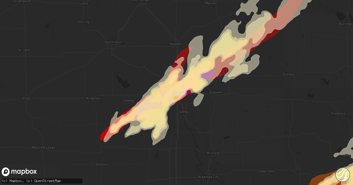
Hail Map in Wichita, KS on May 19, 2013
Get this storm
May 19 map
$229
one time, instant access
Download today. No call, no setup
Keep the $229
Bought the map and want the full workflow? Apply the entire $229 to a subscription within 7 days. None of it is wasted.
Every map, not just this one
This buys you this map. Subscription and you get every map we run, in the markets you choose from a few cities to whole states to nationwide. Plus real-time alerts the moment a storm fires.
Contact data
Name, contact info, occupancy, even credit band for addresses in the footprint. You go from where it hit to who to call.
Become the source they trust
Unlimited branding weather history reports on demand. You already have the documented answer ready for the property owner, and you are the one who showed up with it.
Property data and RoofTrace estimates
Pull up any address you have got, its value and the exact code rules for that jurisdiction, straight from One Click Code. Then RoofTrace estimates the squares, pitch, and roof value, priced the way you price.
Storm reports in Wichita, KS
Wichita, KS
| Date | Description |
|---|---|
| 05/19/20134:18 PM CDT | Spotter was 1 mile west of the butler and sedgewick county line on 45th street north. |
| 05/19/20134:08 PM CDT | A local report indicates 1.75 inch wind near BEL AIRE |
| 05/19/20133:57 PM CDT | Quarter size hail at the kwch office |
| 05/19/20133:46 PM CDT | Golf ball size hail at the nws office |
| 05/19/20133:40 PM CDT | Several trees uprooted near hoover and macarther area |
All States Impacted by Hail Map on May 19, 2013
All Cities Impacted by Hail Map on May 19, 2013
- Deerfield, WI
- Davenport, IA
- Clarksville, IA
- Plainfield, IA
- Allison, IA
- Greene, IA
- Clinton, IA
- Sabula, IA
- Miles, IA
- Two Rivers, WI
- Cushing, OK
- Drumright, OK
- Media, IL
- Wamego, KS
- Belvue, KS
- Lost Nation, IA
- Wheatland, IA
- Calamus, IA
- Grand Mound, IA
- Turon, KS
- Holden, MO
- Kingsville, MO
- Deweese, NE
- Guntersville, AL
- Sparta, TN
- Quebeck, TN
- Doyle, TN
- Walling, TN
- Smithville, TN
- Spencer, TN
- Rock Island, TN
- Forestville, WI
- Algoma, WI
- Cumberland, IA
- Villisca, IA
- Corning, IA
- Carbon, IA
- Massena, IA
- Nodaway, IA
- Dexter, KS
- Reedsburg, WI
- Seymour, WI
- Hollywood, AL
- Stevenson, AL
- Fackler, AL
- Pisgah, AL
- Flat Rock, AL
- Haskell, OK
- Gladstone, IL
- Carman, IL
- Rosalia, KS
- Leon, KS
- Coin, IA
- Mindoro, WI
- Hodgenville, KY
- Sylvia, KS
- Iuka, KS
- Pratt, KS
- Byers, KS
- Grand Island, NE
- Keokuk, IA
- Burlington, IA
- Nora Springs, IA
- Couderay, WI
- Terlton, OK
- Cleveland, OK
- Oklahoma City, OK
- Downs, KS
- Tipton, KS
- Beloit, KS
- Randall, KS
- Osborne, KS
- Glen Elder, KS
- Jewell, KS
- Scottsville, KY
- Andalusia, IL
- Reynolds, IL
- Illinois City, IL
- Milan, IL
- Taylor Ridge, IL
- Leeton, MO
- Dodge City, KS
- Ensign, KS
- Riley, KS
- Bronaugh, MO
- Liberal, MO
- Osmond, NE
- Pierce, NE
- Ravenna, NE
- Williamsburg, KS
- Topeka, KS
- Medford, OK
- Caldwell, KS
- Bellevue, IA
- Delphos, KS
- Concordia, KS
- Aurora, KS
- Little Cedar, IA
- Osage, IA
- Rudd, IA
- Laverne, OK
- Cedar Point, KS
- Colwich, KS
- Norwich, KS
- Potwin, KS
- Garden Plain, KS
- Mayfield, KS
- Kingman, KS
- Burns, KS
- El Dorado, KS
- Maize, KS
- Augusta, KS
- Goddard, KS
- Clearwater, KS
- Argonia, KS
- Cottonwood Falls, KS
- Conway Springs, KS
- Peck, KS
- Viola, KS
- Wichita, KS
- Towanda, KS
- Valley Center, KS
- Matfield Green, KS
- Haysville, KS
- Whitewater, KS
- Andover, KS
- Cheney, KS
- Wellington, KS
- Kechi, KS
- Benton, KS
- Milton, KS
- Greenwich, KS
- Cassoday, KS
- Rockford, IA
- Mason City, IA
- Norman, OK
- Newcastle, OK
- Blanchard, OK
- Hutchinson, KS
- Odessa, MO
- Lone Jack, MO
- Hardin, MO
- Pleasant Hill, MO
- Henrietta, MO
- Richmond, MO
- Oak Grove, MO
- Greenwood, MO
- Mayview, MO
- Napoleon, MO
- Bates City, MO
- Wellington, MO
- Camden, MO
- Lexington, MO
- Lees Summit, MO
- Little York, IL
- Oquawka, IL
- Seaton, IL
- Collyer, KS
- Wakeeney, KS
- Oliver Springs, TN
- Briceville, TN
- Clinton, TN
- Glasgow, KY
- Eighty Eight, KY
- Hillsdale, IL
- Colona, IL
- Glenwood, IA
- Murray, NE
- McClelland, IA
- Plattsmouth, NE
- Underwood, IA
- Nehawka, NE
- Neola, IA
- Pacific Junction, IA
- Bellevue, NE
- Offutt Afb, NE
- Weeping Water, NE
- Council Bluffs, IA
- Manor, GA
- Millwood, GA
- Oakdale, TN
- Harriman, TN
- Natoma, KS
- Paradise, KS
- Waldo, KS
- Oxford, KS
- Joplin, MO
- Mulberry, KS
- Ocala, FL
- Lamar, MO
- Wakita, OK
- Manchester, OK
- Dallas Center, IA
- Elkland, MO
- Buffalo, MO
- Luther, OK
- Wellston, OK
- Arcadia, OK
- Guthrie, OK
- Meridian, OK
- Edmond, OK
- Piedmont, OK
- Coldwater, KS
- Pawhuska, OK
- Shorter, AL
- Hardaway, AL
- Arkansas City, KS
- Onalaska, WI
- Mooreland, OK
- Buffalo, OK
- Alva, OK
- Freedom, OK
- Bouton, IA
- Perry, IA
- Gresham, NE
- Utica, NE
- Lynn Center, IL
- Orion, IL
- Salem, IA
- Saint Marys, KS
- Rossville, KS
- Scottsboro, AL
- Alma, WI
- Cochrane, WI
- Mcminnville, TN
- Braman, OK
- South Haven, KS
- Guide Rock, NE
- Burr Oak, KS
- Milton, IA
- Memphis, MO
- Alexis, IL
- Gerlaw, IL
- Polo, MO
- Hamburg, IA
- Saint Charles, IA
- Indianola, IA
- Prole, IA
- New Virginia, IA
- Banks, AL
- Union Springs, AL
- Burlingame, KS
- Rockford, IL
- Dacoma, OK
- Tampa, KS
- Hope, KS
- Scales Mound, IL
- Galena, IL
- Grandview, IA
- Wapello, IA
- Letts, IA
- Columbus Junction, IA
- Mitchellville, IA
- Perry, KS
- Lecompton, KS
- Morrison, TN
- Holcomb, KS
- Garden City, KS
- Centerville, KS
- Osage City, KS
- Lebo, KS
- Lyndon, KS
- Appleton, WI
- Kaukauna, WI
- Bennington, KS
- Tescott, KS
- Hot Springs, NC
- Charles City, IA
- Edwards, MO
- Burwell, NE
- Fredonia, KS
- Virgil, KS
- Yates Center, KS
- Fall River, KS
- Toronto, KS
- Huxley, IA
- Cambridge, IA
- Clay Center, KS
- Mount Morris, IL
- Forreston, IL
- Leaf River, IL
- Haviland, KS
- Salina, KS
- Brookville, KS
- Ellinwood, KS
- Claflin, KS
- Peachtree City, GA
- Sharpsburg, GA
- Washington, IA
- Keota, IA
- Brighton, IA
- Steinauer, NE
- Brock, NE
- Elk Creek, NE
- Pawnee City, NE
- Johnson, NE
- Tecumseh, NE
- Burchard, NE
- Farmington, IA
- Wayland, MO
- Donnellson, IA
- Argyle, IA
- Silver Creek, NE
- Delia, KS
- Bridgewater, IA
- Prescott, IA
- Belvidere, NE
- Bernard, IA
- Zwingle, IA
- Dubuque, IA
- Maquoketa, IA
- Morganville, KS
- Lehigh, KS
- Canton, KS
- Moundridge, KS
- Galva, KS
- Hillsboro, KS
- Sedgwick, KS
- Montezuma, KS
- Copeland, KS
- Cimarron, KS
- Kirkwood, IL
- Biggsville, IL
- Raritan, IL
- Smithshire, IL
- Stronghurst, IL
- Emporia, KS
- Lexington, NE
- Winfield, IA
- Union Grove, AL
- Osceola, MO
- El Dorado Springs, MO
- Cumming, IA
- West Des Moines, IA
- Riceville, IA
- Prescott, KS
- Hume, MO
- Shelton, NE
- Wood River, NE
- Polk City, IA
- Holy Cross, IA
- Glen Haven, WI
- North Buena Vista, IA
- Sherrill, IA
- Cassville, WI
- Quinter, KS
- Park, KS
- Choctaw, OK
- Amber, OK
- Trion, GA
- Minneapolis, KS
- Fall Creek, WI
- Corning, KS
- Centralia, KS
- Liberty, IL
- Pleasanton, NE
- Gibbon, NE
- Elbing, KS
- Newton, KS
- Maple Hill, KS
- Silver Lake, KS
- Winston, MO
- Pattonsburg, MO
- Weatherby, MO
- Altamont, MO
- Ludowici, GA
- Nicholls, GA
- Waycross, GA
- Mcloud, OK
- Shawnee, OK
- Saint Ansgar, IA
- Plymouth, IA
- Stacyville, IA
- Rockwell, IA
- Mount Pleasant, IA
- Knob Noster, MO
- Whiteman Air Force Base, MO
- Randolph, NE
- Winnebago, IL
- Pecatonica, IL
- Garrison, IA
- Vinton, IA
- Meadow Grove, NE
- West Chester, IA
- Bradyville, TN
- Readyville, TN
- Somers, IA
- Rockwell City, IA
- Knierim, IA
- Manson, IA
- Gravity, IA
- De Soto, IA
- Blue Rapids, KS
- Rock Port, MO
- Home, KS
- Des Moines, IA
- Winterset, IA
- Auburn, NE
- Nevada, IA
- Tarkio, MO
- Riverton, IA
- Van Meter, IA
- Booneville, IA
- Waterville, KS
- Abilene, KS
- Frankfort, KS
- Marysville, KS
- Waukee, IA
- Orient, IA
- Sheldahl, IA
- Slater, IA
- Minburn, IA
- Verdon, NE
- Westboro, MO
- Clarinda, IA
- Kelley, IA
- Vermillion, KS
- Axtell, KS
- Greenfield, IA
- Ames, IA
- Chapman, KS
- Dexter, IA
- Clive, IA
- Beattie, KS
- Elkhart, IA
- Stella, NE
- Seneca, KS
- Manhattan, KS
- Urbandale, IA
- Shubert, NE
- Nemaha, NE
- Menlo, IA
- Du Bois, NE
- Shenandoah, IA
- Stuart, IA
- Westmoreland, KS
- Granger, IA
- Liberty, NE
- Adel, IA
- Olsburg, KS
- Brownville, NE
- Norwalk, IA
- Grimes, IA
- Creston, IA
- Adair, IA
- Falls City, NE
- Ankeny, IA
- Yorktown, IA
- Fairfax, MO
- Milford, KS
- Essex, IA
- Leonardville, KS
- Redfield, IA
- Baileyville, KS
- Summerfield, KS
- Bedford, IA
- Humboldt, NE
- Watson, MO
- Northboro, IA
- Farragut, IA
- Talmage, NE
- Woodward, IA
- Stanton, IA
- Madrid, IA
- Linden, IA
- Table Rock, NE
- Johnston, IA
- Nebraska City, NE
- Casey, IA
- Earlham, IA
- Alleman, IA
- Peru, NE
- Blanchard, IA
- Windsor Heights, IA
- Randolph, KS
- Anita, IA
- Wakefield, KS
- Fontanelle, IA
- Lakin, KS
- Novinger, MO
- Green Castle, MO
- Piedmont, KS
- Atlanta, KS
- Latham, KS
- Cameron, IL
- Galesburg, IL
- Osceola, IA
- Hamilton, IL
- Nauvoo, IL
- Warsaw, IL
- Alexandria, MO
- Wymore, NE
- Warrensburg, MO
- Chilhowee, MO
- Centerview, MO
- Butler, MO
- Spring Hill, KS
- Osceola, NE
- Coffeyville, KS
- Independence, KS
- Wann, OK
- S Coffeyville, OK
- Liberty, KS
- Saint Elizabeth, MO
- Eugene, MO
- Williamstown, MO
- Montrose, IA
- Carthage, IL
- Edina, MO
- Kahoka, MO
- Keithsburg, IL
- Knox City, MO
- Rutledge, MO
- Monmouth, IL
- Danville, IA
- Saint Patrick, MO
- Wyaconda, MO
- Canton, MO
- Middletown, IA
- Lewistown, MO
- West Burlington, IA
- Dallas City, IL
- La Belle, MO
- Fort Madison, IA
- Niota, IL
- Lomax, IL
- Monticello, MO
- West Point, IA
- La Harpe, IL
- Wever, IA
- Oakville, IA
- Denmark, IA
- Chattanooga, TN
- Wildwood, GA
- Lookout Mountain, GA
- Carney, OK
- Cashion, OK
- Okarche, OK
- Sabetha, KS
- Palmer, NE
- Saint Libory, NE
- Saint Paul, NE
- Dannebrog, NE
- New London, IA
- Blackwell, OK
- Alma, KS
- Allen, KS
- Black Creek, WI
- Rising Fawn, GA
- Caney, KS
- Chatsworth, GA
- Dalton, GA
- Bryant, AL
- Bridgeport, AL
- Higdon, AL
- Hebron, NE
- Bruning, NE
- Alexandria, NE
- Satanta, KS
- Ulysses, KS
- Conrad, IA
- Liscomb, IA
- Marshalltown, IA
- Hale, MO
- Eldridge, IA
- Bettendorf, IA
- Le Claire, IA
- Eddyville, NE
- Cozad, NE
- Lancaster, WI
- Potosi, WI
- Hoxie, KS
- Wolbach, NE
- Clifton, KS
- Newark, MO
- Fair Grove, MO
- Montrose, MO
- Leesburg, FL
- Newman Grove, NE
- Saint Edward, NE
- Albion, NE
- Freeport, IL
- Oregon, IL
- Harrah, OK
- Meeker, OK
- Prague, OK
- Newalla, OK
- Sparks, OK
- Graysville, TN
- Dayton, TN
- Ord, NE
- Ericson, NE
- North Loup, NE
- Scotia, NE
- Mound Valley, KS
- Edna, KS
- Rockton, IL
- Rose Creek, MN
- Austin, MN
- Brownsdale, MN
- Dexter, MN
- Lyle, MN
- Dixon, IL
- Amboy, IL
- Franklin Grove, IL
- Screven, GA
- Patterson, GA
- Woodbury, TN
- Olpe, KS
- Lorimor, IA
- Perkins, OK
- Collins, MO
- Mayetta, KS
- Eskridge, KS
- Paxico, KS
- Holton, KS
- Troy, AL
- Brundidge, AL
- Thomasville, GA
- Tryon, OK
- Agra, OK
- Crawfordsville, IA
- Wayland, IA
- Russell, IA
- Chariton, IA
- Jamestown, KS
- Chautauqua, KS
- Sedan, KS
- Peru, KS
- Cedar Vale, KS
- Sarcoxie, MO
- Stotts City, MO
- Wentworth, MO
- Newkirk, OK
- Deer Creek, OK
- Nardin, OK
- Elma, IA
- Boston, GA
- York, NE
- Peterson, MN
- Rockville, MO
- Harwood, MO
- Walker, MO
- Schell City, MO
- Readlyn, IA
- Delta, IA
- Peculiar, MO
- Harrisonville, MO
- Durango, IA
- Peosta, IA
- Platteville, WI
- Lake City, MN
- Stockholm, WI
- Burlington, OK
- Belleville, KS
- Munden, KS
- Longford, KS
- Alda, NE
- Rich Hill, MO
- Richards, MO
- Chester, OK
- Tifton, GA
- Cameron, MO
- Radcliff, KY
- Elizabethtown, KY
- Humphrey, NE
- Platte Center, NE
- Rome, GA
- Scammon, KS
- Parsons, KS
- Frontenac, KS
- West Mineral, KS
- Dearing, KS
- Copan, OK
- Columbus, KS
- Oronogo, MO
- Mindenmines, MO
- Cherryvale, KS
- Tyro, KS
- Altamont, KS
- Cherokee, KS
- McCune, KS
- Pittsburg, KS
- Oswego, KS
- Opolis, KS
- Asbury, MO
- Weir, KS
- Niotaze, KS
- Greenfield, MO
- Onaga, KS
- State Center, IA
- Le Roy, KS
- Neosho Falls, KS
- Neal, KS
- Eureka, KS
- Severy, KS
- Sperry, IA
- Yarmouth, IA
- Oak Ridge, TN
- Knoxville, TN
- Quenemo, KS
- Vassar, KS
- Harrison, TN
- Soddy Daisy, TN
- Tuskegee, AL
- Marshall, WI
- Guttenberg, IA
- Okmulgee, OK
- Okemah, OK
- Beggs, OK
- Mankato, KS
- Oneida, IL
- Wataga, IL
- Windsor, MO
- Elyria, NE
- Notasulga, AL
- Folkston, GA
- Elgin, NE
- Petersburg, NE
- Winchester, KY
- Savanna, IL
- Republic, KS
- Holmen, WI
- Galesville, WI
- Melrose, WI
- Blair, WI
- Ettrick, WI
- Taylor, WI
- Hixton, WI
- Pierceville, KS
- Bloomington, WI
- Fort Davis, AL
- East Moline, IL
- Buffalo, KY
- Louisville, AL
- Stockton, MO
- Humansville, MO
- Dixie, GA
- Stone Lake, WI
- Thomaston, GA
- Lockwood, MO
- Golden City, MO
- Jerico Springs, MO
- Hillsboro, TN
- Milton, TN
- Mount Sterling, IL
- Clayton, IL
- Versailles, IL
- Giltner, NE
- Wausa, NE
- Sauk City, WI
- Mazomanie, WI
- Epworth, IA
- Manchester, TN
- Albany, MO
- Rulo, NE
- White Cloud, KS
- Monroe, NE
- Fort Scott, KS
- Foster, MO
- Avoca, NE
- Lawrence, NE
- Glenvil, NE
- Fairfield, NE
- Altura, MN
- Saint Charles, MN
- Dover, MN
- Minnesota City, MN
- Fountain City, WI
- Rollingstone, MN
- Clermont, FL
- Miami, OK
- Pleasant Hill, IA
- Waco, NE
- Lawson, MO
- Rayville, MO
- Alta Vista, IA
- Lime Springs, IA
- Dougherty, IA
- Le Roy, MN
- Floyd, IA
- Orchard, IA
- Taopi, MN
- Chester, IA
- Adams, MN
- McIntire, IA
- Columbus, NE
- Madison, NE
- Creston, NE
- Lindsay, NE
- Everest, KS
- Robinson, KS
- Sewanee, TN
- Dakota, MN
- La Crescent, MN
- Moline, IL
- Rock Island, IL
- Neosho, MO
- Maysville, MO
- Hortense, GA
- Odum, GA
- Bristol, GA
- Surrency, GA
- Florahome, FL
- Palatka, FL
- Whiting, KS
- Mount Auburn, IA
- Central City, NE
- Fullerton, NE
- Chillicothe, MO
- Chula, MO
- Wheeling, MO
- Deer Lodge, TN
- Jamestown, TN
- Green Ridge, MO
- Hinesville, GA
- Lindenwood, IL
- Rochelle, IL
- Harvard, NE
- Clay Center, NE
- Stockton, IL
- Goose Lake, IA
- Elizabeth, IL
- Mount Carroll, IL
- Teeds Grove, IA
- Bryant, IA
- Aurora, NE
- Burden, KS
- Cambridge, KS
- Rockmart, GA
- Blue Grass, IA
- Buffalo, IA
- La Valle, WI
- Denison, IA
- Newnan, GA
- Newcomb, TN
- Pioneer, TN
- Sturgeon Bay, WI
- Howey In The Hills, FL
- Yalaha, FL
- Maple City, KS
- Adrian, MO
- Ellston, IA
- Shannon City, IA
- Tingley, IA
- Fairfield, IA
- Sunbright, TN
- Pleasanton, KS
- Mapleton, KS
- Fulton, KS
- Redfield, KS
- Elk City, KS
- Fargo, GA
- Iola, KS
- Buffalo, KS
- Piqua, KS
- Spencer, OK
- Jones, OK
- Glennville, GA
- Fort Stewart, GA
- Claxton, GA
- Deerfield, MO
- Moundville, MO
- Nevada, MO
- Mingo, IA
- Collins, IA
- Baxter, IA
- Rhodes, IA
- Concord, GA
- Williamson, GA
- Eyota, MN
- Chatfield, MN
- Montello, WI
- Pardeeville, WI
- Portage, WI
- Winona, MN
- Walnut, KS
- Saint Paul, KS
- Hepler, KS
- Uniontown, KS
- Scandia, KS
- Norway, KS
- Cairo, NE
- Trumbull, NE
- Kearney, NE
- Doniphan, NE
- Jasper, FL
- Wykoff, MN
- Spring Valley, MN
- Amorita, OK
- Dunlap, IA
- Woodbine, IA
- Archer, NE
- Grainfield, KS
- Murray, IA
- Camp Point, IL
- Aline, OK
- Odebolt, IA
- Kiron, IA
- Junction City, KS
- New Hampton, IA
- Nashua, IA
- Ionia, IA
- Jasper, MO
- Stafford, KS
- Roan Mountain, TN
- Ainsworth, IA
- Thomson, IL
- Fulton, IL
- Rock City, IL
- Orangeville, IL
- Dakota, IL
- Clarion, IA
- Belmond, IA
- Holcombe, WI
- Ladysmith, WI
- Timewell, IL
- Parker, KS
- Benedict, NE
- Molena, GA
- Meansville, GA
- Zebulon, GA
- Fairview, OK
- Waynoka, OK
- Weirsdale, FL
- Fruitland Park, FL
- Lady Lake, FL
- Astatula, FL
- Groveland, FL
- Unadilla, GA
- Elko, GA
- Whitwell, TN
- Sylvester, GA
- Elk Falls, KS
- Moline, KS
- Honey Creek, IA
- Omaha, NE
- Carter Lake, IA
- Crescent, IA
- Seneca, MO
- Goodman, MO
- Diamond, MO
- Granby, MO
- Udall, KS
- Greeley, NE
- Gallatin, MO
- Coffey, MO
- Osborn, MO
- Jameson, MO
- Stilwell, KS
- Belton, MO
- Hanover, IL
- Paden, OK
- Dunlap, TN
- Exeland, WI
- Montpelier, IA
- Walcott, IA
- New Boston, IL
- Stockton, IA
- Muscatine, IA
- Joy, IL
- Aledo, IL
- Ty Ty, GA
- Superior, NE
- Beatrice, NE
- Wilmore, KS
- Protection, KS
- Durham, KS
- South Hutchinson, KS
- Barnum, IA
- Ewing, MO
- Louisville, TN
- Farragut, TN
- Pineville, MO
- Bella Vista, AR
- Gilman City, MO
- Bethany, MO
- Glade Spring, VA
- Meadowview, VA
- Saltville, VA
- Milo, MO
- Jesup, GA
- Nahunta, GA
- Shannon, IL
- Harper, KS
- Kingsland, GA
- Chandler, OK
- Eleva, WI
- Archie, MO
- Olmstead, KY
- Allensville, KY
- Mound City, KS
- Saint Marys, IA
- Truro, IA
- Cordova, IL
- Albany, IL
- Port Byron, IL
- Erie, IL
- Meigs, GA
- Hartsfield, GA
- Altamont, TN
- Rushford, MN
- Miller, NE
- Guild, TN
- Trenton, GA
- Ottawa, KS
- Sanderson, FL
- Lascassas, TN
- Dixon, IA
- Delmar, IA
- Scranton, KS
- Adams, NE
- Pembroke, GA
- Senoia, GA
- Corbin, KY
- Kewaunee, WI
- Lanesboro, MN
- Rolla, MO
- Hampton, NE
- Winfield, KS
- Ozark, AL
- Berryton, KS
- Wellman, IA
- Sheffield, IL
- Tecumseh, KS
- Black Earth, WI
- Mount Horeb, WI
- Blue Mounds, WI
- Hazleton, IA
- Independence, IA
- Kalona, IA
- Bristow, OK
- Monticello, WI
- Argyle, WI
- Blanchardville, WI
- Rose Hill, KS
- Verona, WI
- Douglass, KS
- Rock, KS
- Tuttle, OK
- Gypsum, KS
- Grafton, NE
- Sutton, NE
- Eau Claire, WI
- Altoona, WI
- Chippewa Falls, WI
- Meadville, MO
- La Harpe, KS
- Elsmore, KS
- Moran, KS
- Ute, IA
- Dow City, IA
- Charter Oak, IA
- Ludlow, MO
- Braymer, MO
- Utica, MO
- Dawn, MO
- Girard, KS
- Reeds, MO
- Carthage, MO
- Mooresville, MO
- Garden Prairie, IL
- Mineral Point, WI
- Morrison, IL
- Inman, KS
- Shelbyville, MO
- Belvidere, IL
- Poplar Grove, IL
- Lockridge, IA
- Fairburn, GA
- Fayetteville, GA
- Union City, GA
- Tyrone, GA
- Caledonia, MN
- New Albin, IA
- Eitzen, MN
- Kidder, MO
- Clinton, MO
- Urich, MO
- Faribault, MN
- Lonsdale, MN
- Umatilla, FL
- Louisburg, KS
- Paola, KS
- Apopka, FL
- Stockport, IA
- Alta Vista, KS
- Garden City, MO
- Creighton, MO
- Northfield, MN
- Webster, MN
- Weaubleau, MO
- Kellogg, MN
- Ochlocknee, GA
- Pelham, GA
- Fremont, IA
- Ottumwa, IA
- Hedrick, IA
- Ranburne, AL
- Ridott, IL
- Boelus, NE
- Clarks, NE
- Waseca, MN
- Chester, NE
- Hubbell, NE
- Camanche, IA
- De Witt, IA
- Grundy Center, IA
- New Glarus, WI
- Carrollton, MO
- Watertown, TN
- Madison, KS
- Hamilton, KS
- Cherokee, OK
- Harper, IA
- Wyandotte, OK
- Kirkland, IL
- Clare, IL
- Sycamore, IL
- Dekalb, IL
- Fairmount, GA
- Hiawatha, KS
- Dalton, WI
- Russell, KS
- Sidney, IA
- Thayer, IA
- Shullsburg, WI
- Darlington, WI
- De Witt, MO
- Humboldt, IA
- Fort Dodge, IA
- Moorland, IA
- Clare, IA
- Howard, KS
- Longton, KS
- Homerville, GA
- Marquette, KS
- Geneseo, KS
- Ellsworth, KS
- Falun, KS
- Grenola, KS
- Council Grove, KS
- Elba, NE
- Saint Paul, VA
- Coeburn, VA
- Carleton, NE
- Gilead, NE
- Pleasantville, IA
- Runnells, IA
- Prairie City, IA
- Ackworth, IA
- Milo, IA
- Swan, IA
- Hartford, IA
- Chickamauga, GA
- Alcoa, TN
- Rockford, TN
- Grand Meadow, MN
- Racine, MN
- Bentley, KS
- Mount Hope, KS
- Andale, KS
- Liberty, TN
- Shelby, NE
- Boley, OK
- Porter, OK
- Morris, OK
- Yukon, OK
- Stroud, OK
- Chickasha, OK
- Castle, OK
- Depew, OK
- Ulysses, NE
- Marshallville, GA
- Albion, IA
- Heflin, AL
- Hardy, NE
- Byron, NE
- South Pittsburg, TN
- Carl Junction, MO
- Galena, KS
- Baylis, IL
- New Salem, IL
- Plainville, IL
- Griggsville, IL
- Chambersburg, IL
- Barry, IL
- Fennimore, WI
- Princeton, IA
- Coal Valley, IL
- Andrew, IA
- Preston, IA
- Cuba City, WI
- Long Grove, IA
- Donahue, IA
- Cascade, IA
- Spragueville, IA
- New Liberty, IA
- La Motte, IA
- Percival, IA
- Thayer, KS
- Albertville, AL
- Langston, AL
- Groveoak, AL
- Midway, AL
- Woodland, AL
- Livingston, WI
- Stitzer, WI
- Mabel, MN
- Spring Grove, MN
- Houston, MN
- Oskaloosa, IA
- Leighton, IA
- Gay, GA
- Greenville, GA
- Luthersville, GA
- Promise City, IA
- Corydon, IA
- Seymour, IA
- Charlotte, IA
- Humeston, IA
- Newton, IA
- Neodesha, KS
- Altoona, KS
- Lamont, OK
- Mulvane, KS
- Belle Plaine, KS
- Geuda Springs, KS
- Durand, IL
- Mound City, MO
- Rewey, WI
- Belmont, WI
- Hazel Green, WI
- East Dubuque, IL
- Brooks, GA
- Ohiowa, NE
- Milligan, NE
- Reading, KS
- Neosho Rapids, KS
- Peru, IA
- Marion, KS
- Gladbrook, IA
- Sherrard, IL
- Hastings, NE
- Stromsburg, NE
- Polk, NE
- Auburntown, TN
- Utica, MN
- Bessemer, MI
- Brumley, MO
- Richland, MO
- Green, KS
- Osseo, WI
- Strum, WI
- Sterling, KS
- Kent, IL
- Lena, IL
- Sequatchie, TN
- Spivey, KS
- Auburn, KS
- Harveyville, KS
- Packwood, IA
- Loves Park, IL
- Bruce, WI
- Harmony, MN
- Preston, MN
- Johnstown, NE
- Hartsburg, MO
- Chanute, KS
- Mount Vernon, MO
- Afton, OK
- Fairland, OK
- Kincaid, KS
- Derby, KS
- Blairstown, MO
- Atlanta, GA
- Palmetto, GA
- Lithia Springs, GA
- Moreland, GA
- Douglasville, GA
- Wilton, IA
- Orlando, FL
- Tina, MO
- Carbondale, KS
- Fountain, MN
- Maiden Rock, WI
- Cresco, IA
- Genoa, NE
- Larned, KS
- Battle Creek, NE
- Kenesaw, NE
- Solomon, KS
- Miltonvale, KS
- Rushville, MO
- Woodbine, KS
- White City, KS
- Phillips, NE
- Nelson, NE
- Tunnel Hill, GA
- Ringgold, GA
- Trempealeau, WI
- Iberia, MO
- New Canton, IL
- Trenton, MO
- Jamesport, MO
- Marshall, NC
- Elmdale, KS
- Skidmore, MO
- Maitland, MO
- Lancaster, MO
- Glenwood, MO
- Queen City, MO
- Princeton, WI
- Fairbury, NE
- Lenoir City, TN
- Norborne, MO
- White House, TN
- Springfield, TN
- Cross Plains, TN
- Sheldon, MO
- Beloit, WI
- Drexel, MO
- Freeman, MO
- Mishicot, WI
- Casco, WI
- Altona, IL
- Stoughton, WI
- Appleton City, MO
- Beaman, IA
- Birmingham, IA
- Climax Springs, MO
- Denver, IA
- Seligman, MO
- Washburn, MO
- Colony, KS
- Dadeville, MO
- Aldrich, MO
- Peabody, KS
- Fort Riley, KS
- Hartford, KS
- Norfolk, NE
- Grandview, MO
- Grain Valley, MO
- Bucyrus, KS
- Raymore, MO
- Cleveland, MO
- Kansas City, MO
- Overland Park, KS
- Mount Union, IA
- Emmett, KS
- Randalia, IA
- Coats, KS
- Westphalia, KS
- Hampton, TN
- Roxbury, KS
- Assaria, KS
- Allerton, IA
- Excelsior Springs, MO
- Maxwell, IA
- Morning Sun, IA
- Melrose, IA
- Chapman, NE
- Altoona, IA
- Colfax, IA
- Bondurant, IA
- West Salem, WI
- Fair Play, MO
- Bolivar, MO
- Dunnegan, MO
- Sedalia, MO
- Pikeville, TN
- Neligh, NE
- Hokah, MN
- Hamilton, MO
- Kingston, MO
- La Fayette, GA
- Adairville, KY
- Russellville, KY
- Talladega, AL
- Alpine, AL
- Pittsfield, IL
- Cedar Rapids, NE
- Jennings, OK
- Higginsville, MO
- Waverly, AL
- Plum City, WI
- Weston, MO
- Vienna, GA
- Beersheba Springs, TN
- Radisson, WI
- Ojibwa, WI
- Bluejacket, OK
- Roscoe, IL
- Medford, MN
- Denison, KS
- Crossville, TN
- Green City, MO
- Horton, KS
- Mason City, NE
- German Valley, IL
- Baileyville, IL
- Jesup, IA
- Florence, KS
- Portland, MO
- Chamois, MO
- Denton, NE
- Ira, IA
- Melbourne, IA
- Bartlesville, OK
- Lewiston, MN
- Leicester, NC
- Bertrand, NE
- Overton, NE
- McFarland, KS
- Eustis, NE
- Breckenridge, MO
- Darlington, MO
- King City, MO
- La Crosse, WI
- Princeton, MO
- Mcpherson, KS
- Section, AL
- Lincolnville, KS
- Strong City, KS
- Lawrence, KS
- Fenton, IL
- Fort Valley, GA
- Hardy, IA
- Blue Mound, KS
- Carlisle, IA
- Baxter Springs, KS
- Quapaw, OK
- Long Lane, MO
- Ogallah, KS
- Utica, KS
- Mondovi, WI
- Ostrander, MN
- Elliott, IA
- Elmo, MO
- Burlington Junction, MO
- Braddyville, IA
- Clearmont, MO
- Afton, IA
- Keosauqua, IA
- Viola, IL
- Guthrie Center, IA
- Panora, IA
- Milan, KS
- Bogard, MO
- Havensville, KS
- Coolidge, GA
- Flag Pond, TN
- Winigan, MO
- Independence, WI
- Plainview, MN
- Elmer, MO
- Kirksville, MO
- La Plata, MO
- Overbrook, KS
- Wakarusa, KS
- Admire, KS
- Springfield, GA
- Clyo, GA
- Gridley, KS
- Rose Hill, VA
- Marble Rock, IA
- Delaware, OK
- Dallas, GA
- Hiram, GA
- Powder Springs, GA
- Plainview, NE
- Wilsey, KS
- Barneveld, WI
- Hollandale, WI
- New Windsor, IL
- Bosworth, MO
- Valley Falls, KS
- Ooltewah, TN
- Sycamore, GA
- Bartlett, KS
- Greenbrier, TN
- Mediapolis, IA
- Boyceville, WI
- Colfax, WI
- Lancaster, KY
- Prophetstown, IL
- Plevna, KS
- Dewey, OK
- Rising City, NE
- Plano, IA
- Elkton, MN
- Stewartville, MN
- Tallassee, AL
- Adairsville, GA
- La Russell, MO
- Green Cove Springs, FL
- Keystone Heights, FL
- Linn, KS
- Palmer, KS
- Armuchee, GA
- Concordia, MO
- Mount Dora, FL
- Humboldt, KS
- Beaumont, KS
- Cole Camp, MO
- Stover, MO
- Jefferson City, MO
- Welch, OK
- Lovilia, IA
- Sylacauga, AL
- Jasper, TN
- Quincy, MO
- Arcola, MO
- Chase, KS
- Lyons, KS
- Alvaton, KY
- Waverly, IA
- Shell Rock, IA
- Green Bay, WI
- Suamico, WI
- Schleswig, IA
- Camp Hill, AL
- Alton, KS
- Lenapah, OK
- Havana, KS
- Ponca City, OK
- Burbank, OK
- Fairfax, OK
- Shidler, OK
- Hays, KS
- Horton, AL
- Adams, TN
- Cedar Hill, TN
- Ellis, KS
- Plainville, KS
- Little Suamico, WI
- Farlington, KS
- Benedict, KS
- Papillion, NE
- Ashburn, GA
- Saint Joseph, MO
- Henderson, NE
- Exeter, NE
- McCool Junction, NE
- Calhoun, MO
- De Leon Springs, FL
- Pierson, FL
- Pelham, TN
- Rochester, MN
- Abbyville, KS
- Partridge, KS
- Dowelltown, TN
- Marland, OK
- Taft, OK
- Mounds, OK
- Mannford, OK
- Dennis, KS
- Waldron, KS
- Herington, KS
- Sun City, KS
- St John, KS
- Silvis, IL
- Kewanee, IL
- Mineral, IL
- Annawan, IL
- Machesney Park, IL
- Triplett, MO
- Red Oak, IA
- Treynor, IA
- Deloit, IA
- Magnolia, KY
- Arcadia, WI
- Augusta, WI
- Cadott, WI
- Black River Falls, WI
- Austell, GA
- Clarkdale, GA


