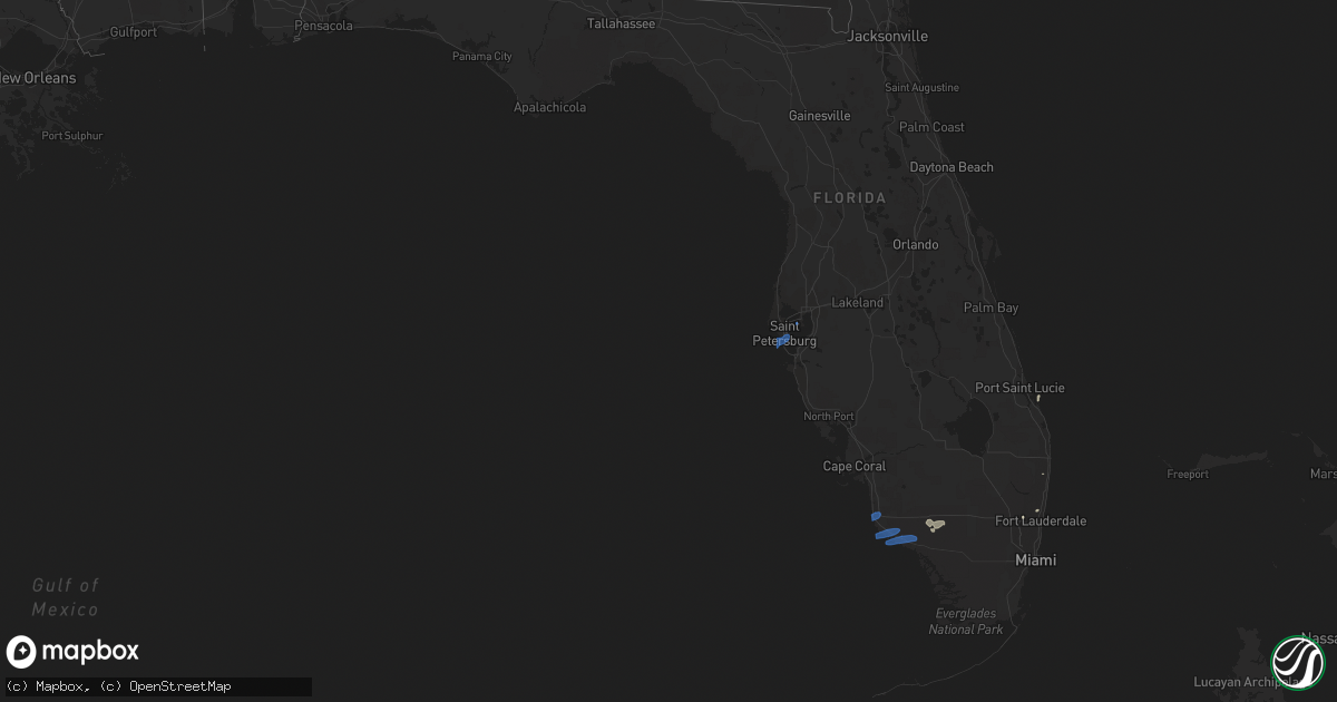
Hail Map in Florida on May 18, 2020
Get this storm
May 18 map
$229
one time, instant access
Download today. No call, no setup
Keep the $229
Bought the map and want the full workflow? Apply the entire $229 to a subscription within 7 days. None of it is wasted.
Every map, not just this one
This buys you this map. Subscription and you get every map we run, in the markets you choose from a few cities to whole states to nationwide. Plus real-time alerts the moment a storm fires.
Contact data
Name, contact info, occupancy, even credit band for addresses in the footprint. You go from where it hit to who to call.
Become the source they trust
Unlimited branding weather history reports on demand. You already have the documented answer ready for the property owner, and you are the one who showed up with it.
Property data and RoofTrace estimates
Pull up any address you have got, its value and the exact code rules for that jurisdiction, straight from One Click Code. Then RoofTrace estimates the squares, pitch, and roof value, priced the way you price.
Storm reports in Florida
Florida
| Date | Description |
|---|---|
| 05/18/20205:05 PM CDT | Report from mping: 1-inch tree limbs broken; shingles blown off. In area of hammock bay golf and country club. |
| 05/18/20204:55 PM CDT | Report from mping: 1-inch tree limbs broken; shingles blown off. In area of hammock bay golf and country club. Corrected time based on wind measurement from marco islan |
| 05/18/20204:37 PM CDT | A wind gust of 58 mph was measured at the earth networks site nplhh at the hamilton harbor yacht club in naples. |
| 05/18/20208:06 AM CDT | Mesonet station optf1 old port tampa... Fl. |
| 05/18/20207:56 AM CDT | Asos station kspg st petersburg - albert whitted. |
| 05/18/20204:23 AM CDT | At 922 AM EDT, severe thunderstorms were located along a line extending from Temple Terrace to near East Lake-Orient Park to near Riverview to near Greater Sun Center, moving northeast at 45 mph. HAZARD...70 mph wind gusts. SOURCE...Radar indicated. IMPACT...Expect considerable tree damage. Damage is likely to mobile homes, roofs, and outbuildings. Locations impacted include... Tampa, Lakeland, Plant City, Temple Terrace, Bartow, Zephyrhills, Fish Hawk, Brandon, Hillsborough River State Park, Zephyrhills South, Palm River-Clair Mel, East Lake-Orient Park, Zephyrhills West, Medulla, Riverview, University, Combee Settlement, Lakeland Linder Airport, Zephyrhills North and Fussels Corner. |
| 05/18/20203:53 AM CDT | At 853 AM EDT, severe thunderstorms were located along a line extending from Bay Pines to Downtown Saint Petersburg to 6 miles east of Fort Desoto Park to West Bradenton, moving northeast at 40 mph. HAZARD...60 mph wind gusts. SOURCE...Radar indicated. IMPACT...Expect damage to roofs, siding, and trees. Locations impacted include... Tampa, Clearwater, Largo, Bradenton, Pinellas Park, Temple Terrace, Seminole, Palmetto, Downtown Saint Petersburg, Fish Hawk, Saint Petersburg, Lutz, Brandon, St. Petersburg, St. Pete Beach, Tampa International Airport, East Lake-Orient Park, Egypt Lake-Leto, Parrish and Ellenton. |
| 05/18/20203:34 AM CDT | At 834 AM EDT, severe thunderstorms were located along a line extending from 12 miles west of Bay Pines to 9 miles south of Anna Maria, moving northeast at 40 mph. HAZARD...60 mph wind gusts. SOURCE...Radar indicated. IMPACT...Expect damage to roofs, siding, and trees. Locations impacted include... Clearwater, Largo, Bradenton, Pinellas Park, Seminole, Palmetto, Downtown Saint Petersburg, Saint Petersburg, Fort Desoto Park, St. Petersburg, St. Pete Beach, Anna Maria, South Highpoint, Tierra Verde, Memphis, West And East Lealman, Parrish, Ridgecrest, Bay Pines and Ellenton. |
| 05/18/20203:10 AM CDT | At 810 PM EDT, a severe thunderstorm was located over Coral Gables, moving east at 30 mph. HAZARD...60 mph wind gusts and penny size hail. SOURCE...Radar indicated. IMPACT...Expect damage to roofs, siding, and trees. Locations impacted include... Miami, Miami Beach, Coral Gables, Key Biscayne and South Miami. |
| 05/18/20201:01 AM CDT | At 600 PM EDT, a severe thunderstorm was located over Royal Palm Hammock, or 9 miles northeast of Marco Island, moving east at 30 mph. HAZARD...60 mph wind gusts and penny size hail. SOURCE...Radar indicated. IMPACT...Expect damage to roofs, siding, and trees. Locations impacted include... Marco Island, Chokoloskee, Everglades City, Plantation Island and Carnestown. |
| 05/18/202012:28 AM CDT | At 527 PM EDT, a severe thunderstorm was located over Naples, moving east at 25 mph. HAZARD...70 mph wind gusts and quarter size hail. SOURCE...Radar indicated. IMPACT...Hail damage to vehicles is expected. Expect considerable tree damage. Wind damage is also likely to mobile homes, roofs, and outbuildings. Locations impacted include... Naples, Golden Gate Estates, Belle Meade, Marco Island Airport and Orangetree. |
| 05/17/202010:17 PM CDT | At 316 PM EDT, severe thunderstorms were located along a line extending from 8 miles west of Coral Springs to near Intersection I-75 And U.S. 27 to 14 miles west of Intersection Krome And U.S. 27, moving east at 30 mph. HAZARD...60 mph wind gusts and penny size hail. SOURCE...Radar indicated. IMPACT...Expect damage to roofs, siding, and trees. Locations impacted include... Fort Lauderdale, Pembroke Pines, Miramar, Coral Springs and Pompano Beach. |
| 05/17/20209:53 PM CDT | At 253 PM EDT, severe thunderstorms were located along a line extending from near Holey Land Wildlife Refuge to 6 miles west of Intersection Alligator Alley And Miami Canal, moving north at 20 mph. HAZARD...60 mph wind gusts and quarter size hail. SOURCE...Radar indicated. IMPACT...Hail damage to vehicles is expected. Expect wind damage to roofs, siding, and trees. Locations impacted include... Belle Glade, Pahokee, South Bay, Canal Point and Lake Harbor. |
| 05/17/20208:54 PM CDT | At 153 PM EDT, a severe thunderstorm was located 8 miles west of Loxahatchee NWR, or 14 miles north of Coral Springs, moving northeast at 20 mph. HAZARD...60 mph wind gusts and quarter size hail. SOURCE...Radar indicated. IMPACT...Hail damage to vehicles is expected. Expect wind damage to roofs, siding, and trees. Locations impacted include... Boca Raton, Boynton Beach, Delray Beach, Wellington and Highland Beach. |
| 05/17/20208:50 PM CDT | At 150 PM EDT, a severe thunderstorm was located 9 miles northwest of Big Cypress National Preserve, or 23 miles southeast of Ave Maria, moving northeast at 15 mph. HAZARD...60 mph wind gusts and quarter size hail. SOURCE...Radar indicated. IMPACT...Hail damage to vehicles is expected. Expect wind damage to roofs, siding, and trees. Locations impacted include... Miccosukee Indian Reservation and Big Cypress National Preserve. |
| 05/17/20207:20 PM CDT | An off duty nws employee reported a large branch broke of a tree at the intersection of mashta drive and allendale road. |
All States Impacted by Hail Map on May 18, 2020
Cities Impacted by Hail Map on May 18, 2020
- Galt, CA
- Wilton, CA
- Herald, CA
- Moccasin, MT
- Stanford, MT
- Nicholasville, KY
- Augusta, MT
- Batesburg, SC
- Somerset, KY
- Stuart, FL
- Boynton Beach, FL
- Hilham, TN
- Gainesboro, TN
- Celina, TN
- Hobson, MT
- White Plains, GA
- Denton, MT
- Coffee Creek, MT
- Lewistown, MT
- Ochopee, FL
- Mount Vernon, KY
- Brodhead, KY
- Stapleton, GA
- Whitleyville, TN
- Wolf Creek, MT
- Simms, MT
- Fort Shaw, MT
- Cascade, MT
- Fairfield, MT
- Louisville, GA
- Pompano Beach, FL
- Fort Lauderdale, FL
- Sun River, MT
- Vaughn, MT
- Power, MT
- Monticello, KY
- Saint Petersburg, FL
- Tampa, FL
- Naples, FL
- Marco Island, FL
- Goodland, FL
- Livingston, KY
- East Bernstadt, KY
- Mount Sterling, OH
- Orient, OH
- Hilliard, OH
- London, OH
- West Jefferson, OH
- Galloway, OH
- Grove City, OH
- Columbus, OH


