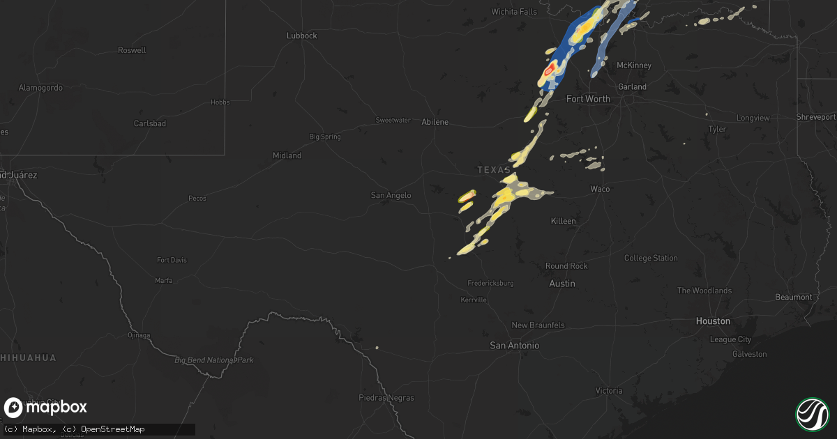
Hail Map in Texas on May 17, 2025
Get this storm
May 17 map
$229
one time, instant access
Download today. No call, no setup
Keep the $229
Bought the map and want the full workflow? Apply the entire $229 to a subscription within 7 days. None of it is wasted.
Every map, not just this one
This buys you this map. Subscription and you get every map we run, in the markets you choose from a few cities to whole states to nationwide. Plus real-time alerts the moment a storm fires.
Contact data
Name, contact info, occupancy, even credit band for addresses in the footprint. You go from where it hit to who to call.
Become the source they trust
Unlimited branding weather history reports on demand. You already have the documented answer ready for the property owner, and you are the one who showed up with it.
Property data and RoofTrace estimates
Pull up any address you have got, its value and the exact code rules for that jurisdiction, straight from One Click Code. Then RoofTrace estimates the squares, pitch, and roof value, priced the way you price.
Storm reports in Texas
Texas
| Date | Description |
|---|---|
| 05/17/20256:50 PM CDT | Half dollar size hail at cr437 and cr408 in cooke county. |
| 05/17/20256:38 PM CDT | Social media picture of golf ball hail in muenster. |
| 05/17/20256:31 PM CDT | Quarter size hail in muenster via em. |
| 05/17/20256:25 PM CDT | 60-65 mph winds estimated on fm922 at montague-cooke county line. Tree damage and items blown around. |
| 05/17/20256:21 PM CDT | Kdto asos 58kt. |
| 05/17/20255:59 PM CDT | Report from mping. |
| 05/17/20255:56 PM CDT | Report from mping. |
| 05/17/20255:53 PM CDT | Baseball size hail just south of runaway bay. |
| 05/17/20255:50 PM CDT | Stormchaser video showed several trees blown down onto hwy 114 between bridgeport and paradise. |
| 05/17/20255:45 PM CDT | Several facebook reports of numerous trees down in and around paradise with some outbuildings damaged. |
| 05/17/20255:42 PM CDT | 70 mph estimated winds in joplin. |
| 05/17/20255:41 PM CDT | Roof and awning damage on jefferson st. In whitney. (fw |
| 05/17/20255:41 PM CDT | Stormchaser photo showed a hail stone approximately 3.25 inches long by 2.5 inches wide fell in joplin. |
| 05/17/20255:41 PM CDT | Roof and awning damage on jefferson st. In whitney. |
| 05/17/20255:41 PM CDT | A local report indicates 0 MPH wind near Whitney |
| 05/17/20255:40 PM CDT | Ping pong ball size hail in joplin. |
| 05/17/20255:40 PM CDT | Trees down in the 100 block of bonita drive. |
| 05/17/20255:36 PM CDT | Quarter size hail at juniper cove marina on lake whitney. |
| 05/17/20255:22 PM CDT | Quarter size hail in mineral wells via social media pictures. |
| 05/17/20254:48 PM CDT | Repor |
| 05/17/20254:48 PM CDT | Report from mping: quarter |
| 05/17/20253:10 PM CDT | Power line down. Inactive. |
| 05/17/20252:55 PM CDT | Quarter size hail. |
| 05/16/20259:00 PM CDT | Trees down on highway 37 just before the red river. |
| 05/16/20258:48 PM CDT | Trees down on fm road 195 in manchester area. |
| 05/16/20258:33 PM CDT | Numerous trees down from the novice community northeastward into red river county. |
| 05/16/20258:33 PM CDT | Nume |
| 05/16/20258:15 PM CDT | Trees down near intersection of hwy 155 and fm road 2685. |
| 05/16/20257:28 PM CDT | Trees down in the hoard community about 1 mile past fm road 1804. Also... Estimated hail up to quarter size. |
| 05/16/20257:27 PM CDT | Many facebook reports of numerous trees down across denison with widespread power outages. |
| 05/16/20257:27 PM CDT | Public reports lots of tree limbs down on country road 431 via social media. |
| 05/16/20257:24 PM CDT | Roof damage at a pharmacy and trees down along fm 120 in pottsboro. |
| 05/16/20257:10 PM CDT | 60 mph winds near and north of whitesboro. Damage along hwy 377 at ferguson rd. |
All States Impacted by Hail Map on May 17, 2025
Cities Impacted by Hail Map on May 17, 2025
- Thorsby, AL
- Clanton, AL
- Franklin, GA
- Grantville, GA
- Newnan, GA
- Gouverneur, NY
- Moreland, GA
- Senoia, GA
- Sharpsburg, GA
- Laurens, SC
- Luthersville, GA
- Massena, NY
- Norfolk, NY
- Brasher Falls, NY
- Zebulon, GA
- Williamson, GA
- Griffin, GA
- Barnesville, GA
- Forsyth, GA
- Norwood, NY
- Milner, GA
- Bombay, NY
- Fort Covington, NY
- Holland Patent, NY
- Rome, NY
- Remsen, NY
- Rochester, NY
- Pittsford, NY
- Scottsville, NY
- Caledonia, NY
- Rush, NY
- West Henrietta, NY
- Cold Brook, NY
- Duanesburg, NY
- Schenectady, NY
- Parish, NY
- Pulaski, NY
- Altmar, NY
- Ballston Lake, NY
- Burnt Hills, NY
- Mechanicville, NY
- Williamstown, NY
- Stittville, NY
- Ballston Spa, NY
- Round Lake, NY
- Redford, NY
- Saranac, NY
- Schuyler Falls, NY
- Saratoga Springs, NY
- Edwards, MS
- Vicksburg, MS
- Bolton, MS
- Charlotte, VT
- North Ferrisburgh, VT
- Ferrisburgh, VT
- Shelburne, VT
- Bristol, VT
- Hinesburg, VT
- New Haven, VT
- Clinton, MS
- Raymond, MS
- Jackson, MS
- South Burlington, VT
- Westport, NY
- Essex, NY
- Vergennes, VT
- Williston, VT
- Essex Junction, VT
- Cadyville, NY
- Morrisonville, NY
- Peru, NY
- Richmond, VT
- Huntington, VT
- Byram, MS
- Thendara, NY
- Eagle Bay, NY
- Jericho, VT
- Plattsburgh, NY
- Schroon Lake, NY
- Willsboro, NY
- Adirondack, NY
- Starksboro, VT
- Colchester, VT
- Lohn, TX
- Brady, TX
- Pottersville, NY
- Brant Lake, NY
- Middlebury, VT
- Rochelle, TX
- Mason, TX
- Stowe, VT
- Mullin, TX
- Goldthwaite, TX
- Morrisville, VT
- Hyde Park, VT
- Rockwood, TX
- Santa Anna, TX
- Brookesmith, TX
- Priddy, TX
- Richland Springs, TX
- Northville, NY
- Comanche, TX
- San Saba, TX
- Utica, NY
- Marcy, NY
- Whitesboro, NY
- Flora, MS
- Junction, TX
- Poland, NY
- Barneveld, NY
- Frankfort, NY
- Underhill, VT
- Cambridge, VT
- Waterbury, VT
- Porter Corners, NY
- Art, TX
- Waterbury Center, VT
- Valley Spring, TX
- Pontotoc, TX
- Greenfield Center, NY
- Newport, NY
- Corinth, NY
- Gustine, TX
- Lake Luzerne, NY
- Gansevoort, NY
- Wolcott, VT
- Hamilton, TX
- Richland, MS
- Dublin, TX
- Spearsville, LA
- Evant, TX
- Star, TX
- Marlow, OK
- Rush Springs, OK
- Pottsville, TX
- Carlton, TX
- Voca, TX
- Fredonia, TX
- Madill, OK
- Kingston, OK
- Ninnekah, OK
- Strong, AR
- Huttig, AR
- Fort Edward, NY
- Raleigh, MS
- Stephenville, TX
- Schuylerville, NY
- Chickasha, OK
- Bradley, OK
- Amber, OK
- Pioneer, LA
- Oak Grove, LA
- Lampasas, TX
- Greenwich, NY
- Tuttle, OK
- Lindsay, OK
- Gordon, TX
- Santo, TX
- Pine Hill, AL
- Alex, OK
- Bluff Dale, TX
- Purmela, TX
- Mingus, TX
- Hamburg, AR
- Jonesboro, TX
- Mustang, OK
- Oklahoma City, OK
- Newcastle, OK
- Yukon, OK
- Wheatland, OK
- Blanchard, OK
- Tolar, TX
- Lake Providence, LA
- Lipan, TX
- Woodstock, VT
- Stillwater, NY
- Iredell, TX
- Gatesville, TX
- Bethany, OK
- Maysville, OK
- Paoli, OK
- Wayne, OK
- Pauls Valley, OK
- Morgan, TX
- Meridian, TX
- Quechee, VT
- Hartland, VT
- White River Junction, VT
- Millsap, TX
- Richmond, MA
- Pittsfield, MA
- West Lebanon, NH
- North Hartland, VT
- Taftsville, VT
- Portland, AR
- Walnut Springs, TX
- Mineral Wells, TX
- Schaghticoke, NY
- Perrin, TX
- Graford, TX
- Weatherford, TX
- Whitt, TX
- Byars, OK
- Purcell, OK
- Camden, AL
- Transylvania, LA
- Thetford Center, VT
- South Strafford, VT
- Enfield, NH
- Wilder, VT
- Lebanon, NH
- Hanover, NH
- Hinsdale, MA
- Becket, MA
- Lenox, MA
- Dalton, MA
- Plainfield, NH
- Mayersville, MS
- Rolling Fork, MS
- Poolville, TX
- Jacksboro, TX
- Bridgeport, TX
- Canaan, NH
- Stratford, OK
- Vredenburgh, AL
- Etna, NH
- Lexington, OK
- Grantham, NH
- Pine Apple, AL
- Blum, TX
- Springtown, TX
- Paradise, TX
- Whitney, TX
- Caddo, OK
- Caney, OK
- Chico, TX
- Decatur, TX
- Bonita, LA
- Jones, LA
- Beatrice, AL
- Parkdale, AR
- Hillsboro, TX
- Itasca, TX
- Wanette, OK
- Kopperl, TX
- Abbott, TX
- Aquilla, TX
- Clifton, TX
- Fort Worth, TX
- Keller, TX
- Ada, OK
- Cherokee, TX
- Alvord, TX
- West, TX
- Forestburg, TX
- Roanoke, TX
- Argyle, TX
- Justin, TX
- Georgiana, AL
- Bowie, TX
- Fort Rucker, AL
- Valley Park, MS
- Sunset, TX
- Evergreen, AL
- Muenster, TX
- Saint Jo, TX
- Asher, OK
- Konawa, OK
- Denton, TX
- Ponder, TX
- Sanger, TX
- Aubrey, TX
- Valley View, TX
- Rosston, TX
- Gainesville, TX
- Montague, TX
- Era, TX
- Lindsay, TX
- Nocona, TX
- Thackerville, OK
- Burneyville, OK
- Leon, OK
- Wilmot, AR
- Newton, AL
- Ozark, AL
- Marietta, OK
- Bennett, CO
- Allen, OK
- Stonewall, OK
- Coalgate, OK
- Centrahoma, OK
- Calvin, OK
- Strasburg, CO
- Sasakwa, OK
- Whitesboro, TX
- Stuart, OK
- Collinsville, TX
- Sadler, TX
- Gordonville, TX
- Pottsboro, TX
- Mead, OK
- Wardville, OK
- Sherman, TX
- Denison, TX
- Ardmore, OK
- Lebanon, OK
- Tupelo, OK
- Lindale, TX
- Kiowa, OK
- Atoka, OK
- Pittsburg, OK
- Severy, KS
- Mill Creek, OK
- Mannsville, OK
- Tishomingo, OK
- Calera, OK
- Colbert, OK
- Hendrix, OK
- Kenefic, OK
- Athens, TX
- Stringtown, OK
- Daisy, OK
- Milburn, OK
- Weare, NH
- Okolona, AR
- Gurdon, AR
- Wapanucka, OK
- Sumner, TX
- Antlers, OK
- Yates Center, KS
- Arkadelphia, AR
- Powderly, TX
- Paris, TX
- Clayton, OK
- Sharon, OK
- Wynnewood, OK
- Blossom, TX
- Humboldt, KS
- Woodward, OK
- Detroit, TX
- Coy, AL
- Lafayette, AL
- Maud, OK
- Parker, KS
- Centerville, KS
- Bagwell, TX
- Savonburg, KS
- Elsmore, KS
- Snow, OK
- Nashoba, OK
- Mcalester, OK
- Garvin, OK
- Clarksville, TX
- Red Oak, OK
- Erie, KS
- Moran, KS
- Idabel, OK
- Heavener, OK
- Mccurtain, OK
- Garnett, KS
- Uniontown, KS
- Stark, KS
- Wewoka, OK
- Hepler, KS
- Amity, AR
- Sparkman, AR
- Seiling, OK
- Edmond, OK
- Holdenville, OK
- Neosho Falls, KS
- Guthrie, OK
- Virgil, KS
- Gridley, KS
- Westphalia, KS
- Redfield, KS
- Hartford, KS
- Burlington, KS
- Broken Bow, OK
- Le Roy, KS
- Hodgen, OK
- Fort Scott, KS
- Seminole, OK
- Wetumka, OK
- Choctaw, OK
- Newalla, OK
- Booneville, AR
- Arcadia, OK
- Bethel, OK
- Jones, OK
- Parsons, KS
- Galesburg, KS
- Honobia, OK
- Mansfield, AR
- Toronto, KS
- Luther, OK
- Iola, KS
- Colony, KS
- Saint Paul, KS
- Spencer, OK
- Mcloud, OK
- Shawnee, OK
- La Harpe, KS
- Fall River, KS
- Donaldson, AR
- Brackettville, TX
- Bismarck, AR
- Harrah, OK
- Clinton, OK
- Yale, OK
- Maramec, OK
- Malvern, AR
- Kincaid, KS
- Pawnee, OK
- Stillwater, OK
- Jennings, OK
- Glencoe, OK
- Girard, KS
- Meeker, OK
- McCune, KS
- Watonga, OK
- Thomas, OK
- Foss, OK
- Arapaho, OK
- Earlsboro, OK
- Sheldon, MO
- Cleveland, OK
- Weatherford, OK
- Geary, OK
- Fredonia, KS
- Bronson, KS
- Pittsburg, KS
- Osage, OK
- Hominy, OK
- Newkirk, OK
- Canute, OK
- Corn, OK
- Piqua, KS
- Chanute, KS
- Skiatook, OK
- Barnsdall, OK
- Hitchcock, OK
- Kingfisher, OK
- Loyal, OK
- Hennessey, OK
- Ponca City, OK
- Kaw City, OK
- Okeene, OK
- Waukomis, OK
- Pine Bluff, AR
- Grady, AR
- Carthage, AR
- Shidler, OK
- Leola, AR
- Ames, OK
- Bison, OK
- Calumet, OK
- Laredo, TX
- Walnut, KS
- Coyle, OK
- Burbank, OK
- Orlando, OK
- Mulhall, OK
- White Hall, AR
- Hydro, OK
- Perkins, OK
- Yorktown, AR
- Gould, AR
- Okarche, OK
- Moundville, MO
- Stuttgart, AR
- Milo, MO
- Ripley, OK
- Cushing, OK
- El Dorado Springs, MO
- El Reno, OK
- Gillett, AR
- Piedmont, OK
- Jerico Springs, MO
- Snow Lake, AR
- Glenpool, OK
- Bixby, OK
- Stroud, OK
- Wellston, OK
- Mounds, OK
- Duncan, MS
- Kiefer, OK
- Gunnison, MS
- Merigold, MS
- Mound Bayou, MS
- Rosedale, MS
- Chandler, OK
- Norman, OK
- Broken Arrow, OK
- Coweta, OK
- Sparks, OK
- Bristow, OK
- Kellyville, OK
- Depew, OK
- Doddsville, MS
- Shaw, MS
- Beggs, OK
- Sapulpa, OK
- Cleveland, MS
- Boyle, MS
- Prague, OK
- Paden, OK
- Ruleville, MS
- Minter City, MS
- Castle, OK
- Drew, MS
- Okemah, OK
- Schlater, MS
- Indianola, MS
- Sunflower, MS
- Okmulgee, OK
- Boley, OK
- Henryetta, OK
- Greenwood, MS
- Philipp, MS
- Council Hill, OK
- Carrollton, MS
- Moorhead, MS
- Morris, OK
- Boynton, OK
- Sidon, MS
- Weleetka, OK
- Muskogee, OK
- Coila, MS
- Oktaha, OK
- Checotah, OK
- Warner, OK
- Gore, OK
- Webbers Falls, OK
- Winona, MS
- McCarley, MS
- Dustin, OK
- Vian, OK
- Stigler, OK
- Porum, OK
- Eufaula, OK
- Hanna, OK
- Uniontown, AR
- Sallisaw, OK
- Gans, OK
- Indianola, OK
- Muldrow, OK
- Keota, OK
- Bokoshe, OK
- Spiro, OK
- Shady Point, OK
- Roland, OK
- Pocola, OK
- Alma, AR
- Van Buren, AR
- Fort Smith, AR
- Poteau, OK
- Natural Dam, AR
- Arkoma, OK
- Greenwood, AR
- Haskell, OK
- Starkville, MS
- Lavaca, AR
- Charleston, AR
- West Point, MS
- Magazine, AR
- Huntington, AR
- Whitefield, OK
- Barling, AR
- Aberdeen, MS
- Ozark, AR
- Paris, AR
- Branch, AR
- Cecil, AR
- Columbus, MS
- Ethelsville, AL
- Brookwood, AL
- Scranton, AR
- Hartman, AR
- Coal Hill, AR
- Lamar, AR
- New Blaine, AR
- Clarksville, AR
- Prue, OK
- McCalla, AL
- Vance, AL
- Reform, AL
- Millport, AL
- Knoxville, AR
- London, AR
- Delaware, AR
- Atkins, AR
- Russellville, AR
- Pottsville, AR
- Morrilton, AR
- Coker, AL
- Northport, AL
- Buhl, AL
- Dover, AR
- Bessemer, AL
- Elrod, AL
- Sperry, OK
- Gordo, AL
- Birmingham, AL
- Alabaster, AL
- Tuscaloosa, AL
- Calera, AL
- Plumerville, AR
- Hattieville, AR
- Tulsa, OK
- Helena, AL
- Pelham, AL
- Chelsea, AL
- Wilsonville, AL
- Columbiana, AL
- Greenbrier, AR
- Sylacauga, AL
- Shelby, AL
- Mount Olive, AL
- Goodwater, AL
- Weogufka, AL
- Adger, AL
- Conway, AR
- Sterrett, AL
- Owasso, OK
- Subiaco, AR
- Blue Mountain, AR
- Havana, AR
- Waldron, AR
- Ratcliff, AR
- Altus, AR
- Belleville, AR
- Dardanelle, AR
- Hector, AR
- Danville, AR
- Perryville, AR
- Briggsville, AR
- Harvey, AR
- Bluffton, AR
- Gravelly, AR
- Ola, AR
- Casa, AR
- Plainview, AR
- Rover, AR
- Springfield, AR
- Solgohachia, AR
- Adona, AR
- Vilonia, AR
- Jerusalem, AR
- Mayflower, AR
- Perry, AR
- Bigelow, AR
- Houston, AR
- Wooster, AR
- Maumelle, AR
- Roland, AR
- Paron, AR
- North Little Rock, AR
- Little Rock, AR
- Benton, AR
- Hot Springs Village, AR
- Alexander, AR
- Dolomite, AL
- Echola, AL
- West Blocton, AL
- Woodstock, AL
- Cottondale, AL
- Pleasant Grove, AL
- Fairfield, AL
- Brierfield, AL
- Montevallo, AL
- Harpersville, AL
- Childersburg, AL
- Vincent, AL
- Gardendale, AL
- Jacksonville, AR
- Sherwood, AR
- Vandiver, AL
- Leeds, AL
- Chester, AR
- Dyer, AR
- Stilwell, OK
- Mountainburg, AR
- Mulberry, AR
- Rudy, AR
- Cedarville, AR
- Hackett, AR
- Cameron, OK
- Bunch, OK
- Braggs, OK
- Midland, AR
- Hartford, AR
- Jessieville, AR
- Little Rock Air Force Base, AR
- Cabot, AR
- Ragland, AL
- Ohatchee, AL
- Ashland, AL
- Talladega, AL
- Alpine, AL
- Cropwell, AL


