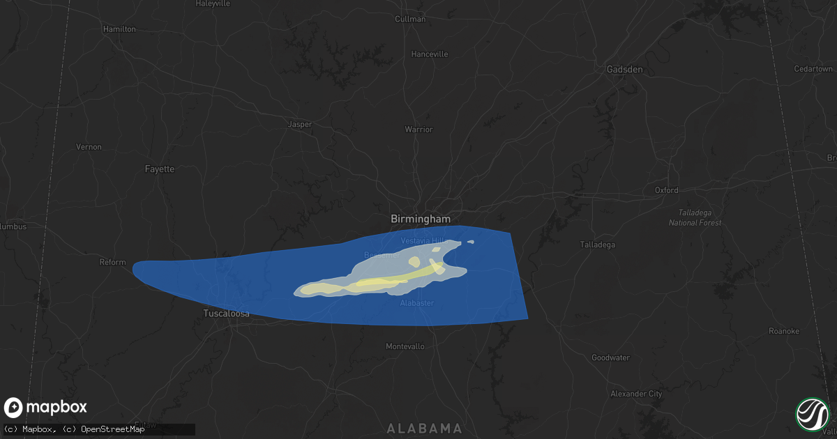
Hail Map in Birmingham, AL on May 17, 2025
Get this storm
May 17 map
$229
one time, instant access
Download today. No call, no setup
Keep the $229
Bought the map and want the full workflow? Apply the entire $229 to a subscription within 7 days. None of it is wasted.
Every map, not just this one
This buys you this map. Subscription and you get every map we run, in the markets you choose from a few cities to whole states to nationwide. Plus real-time alerts the moment a storm fires.
Contact data
Name, contact info, occupancy, even credit band for addresses in the footprint. You go from where it hit to who to call.
Become the source they trust
Unlimited branding weather history reports on demand. You already have the documented answer ready for the property owner, and you are the one who showed up with it.
Property data and RoofTrace estimates
Pull up any address you have got, its value and the exact code rules for that jurisdiction, straight from One Click Code. Then RoofTrace estimates the squares, pitch, and roof value, priced the way you price.
Storm reports in Birmingham, AL
Birmingham, AL
| Date | Description |
|---|---|
| 05/17/20256:45 AM CDT | Tree down blocking the road along kinross drive near brook highland trace. |
| 05/17/20256:43 AM CDT | Fire department responding to a report of a tree down near the intersection of brrok highland parkway and brook highland drive. |
| 05/17/20256:43 AM CDT | Trees and power lines down blocking pump house road near caldwell mill road. |
| 05/17/20256:42 AM CDT | Fire department responding to a report of a tree down along highway 11 near sports highland parkway. |
| 05/17/20256:38 AM CDT | Vestavia hills fd responding to report of a tree that fell on a home and damaged the front porch. |
| 05/17/20256:20 AM CDT | Large oak fell on deck and carport. |
| 05/17/20256:14 AM CDT | Report of power lines down near the intersection of old leeds road and cherokee road... Mountain brook fd responding. |
| 05/17/20256:08 AM CDT | Tree fell on a house along with several trees down in the area per trained spotter relaying scanner traffic. |
| 05/17/20256:04 AM CDT | A local report indicates 1.00 inch wind near 2 SSE Lake Cyrus |
| 05/17/20256:02 AM CDT | Public report of quarter size hail via social media. |
| 05/17/20256:02 AM CDT | Broadcast media relayed public photo of hail near hoover. |
All States Impacted by Hail Map on May 17, 2025
All Cities Impacted by Hail Map on May 17, 2025
- Thorsby, AL
- Clanton, AL
- Franklin, GA
- Grantville, GA
- Newnan, GA
- Gouverneur, NY
- Moreland, GA
- Senoia, GA
- Sharpsburg, GA
- Laurens, SC
- Luthersville, GA
- Massena, NY
- Norfolk, NY
- Brasher Falls, NY
- Zebulon, GA
- Williamson, GA
- Griffin, GA
- Barnesville, GA
- Forsyth, GA
- Norwood, NY
- Milner, GA
- Bombay, NY
- Fort Covington, NY
- Holland Patent, NY
- Rome, NY
- Remsen, NY
- Rochester, NY
- Pittsford, NY
- Scottsville, NY
- Caledonia, NY
- Rush, NY
- West Henrietta, NY
- Cold Brook, NY
- Duanesburg, NY
- Schenectady, NY
- Parish, NY
- Pulaski, NY
- Altmar, NY
- Ballston Lake, NY
- Burnt Hills, NY
- Mechanicville, NY
- Williamstown, NY
- Stittville, NY
- Ballston Spa, NY
- Round Lake, NY
- Redford, NY
- Saranac, NY
- Schuyler Falls, NY
- Saratoga Springs, NY
- Edwards, MS
- Vicksburg, MS
- Bolton, MS
- Charlotte, VT
- North Ferrisburgh, VT
- Ferrisburgh, VT
- Shelburne, VT
- Bristol, VT
- Hinesburg, VT
- New Haven, VT
- Clinton, MS
- Raymond, MS
- Jackson, MS
- South Burlington, VT
- Westport, NY
- Essex, NY
- Vergennes, VT
- Williston, VT
- Essex Junction, VT
- Cadyville, NY
- Morrisonville, NY
- Peru, NY
- Richmond, VT
- Huntington, VT
- Byram, MS
- Thendara, NY
- Eagle Bay, NY
- Jericho, VT
- Plattsburgh, NY
- Schroon Lake, NY
- Willsboro, NY
- Adirondack, NY
- Starksboro, VT
- Colchester, VT
- Lohn, TX
- Brady, TX
- Pottersville, NY
- Brant Lake, NY
- Middlebury, VT
- Rochelle, TX
- Mason, TX
- Stowe, VT
- Mullin, TX
- Goldthwaite, TX
- Morrisville, VT
- Hyde Park, VT
- Rockwood, TX
- Santa Anna, TX
- Brookesmith, TX
- Priddy, TX
- Richland Springs, TX
- Northville, NY
- Comanche, TX
- San Saba, TX
- Utica, NY
- Marcy, NY
- Whitesboro, NY
- Flora, MS
- Junction, TX
- Poland, NY
- Barneveld, NY
- Frankfort, NY
- Underhill, VT
- Cambridge, VT
- Waterbury, VT
- Porter Corners, NY
- Art, TX
- Waterbury Center, VT
- Valley Spring, TX
- Pontotoc, TX
- Greenfield Center, NY
- Newport, NY
- Corinth, NY
- Gustine, TX
- Lake Luzerne, NY
- Gansevoort, NY
- Wolcott, VT
- Hamilton, TX
- Richland, MS
- Dublin, TX
- Spearsville, LA
- Evant, TX
- Star, TX
- Marlow, OK
- Rush Springs, OK
- Pottsville, TX
- Carlton, TX
- Voca, TX
- Fredonia, TX
- Madill, OK
- Kingston, OK
- Ninnekah, OK
- Strong, AR
- Huttig, AR
- Fort Edward, NY
- Raleigh, MS
- Stephenville, TX
- Schuylerville, NY
- Chickasha, OK
- Bradley, OK
- Amber, OK
- Pioneer, LA
- Oak Grove, LA
- Lampasas, TX
- Greenwich, NY
- Tuttle, OK
- Lindsay, OK
- Gordon, TX
- Santo, TX
- Pine Hill, AL
- Alex, OK
- Bluff Dale, TX
- Purmela, TX
- Mingus, TX
- Hamburg, AR
- Jonesboro, TX
- Mustang, OK
- Oklahoma City, OK
- Newcastle, OK
- Yukon, OK
- Wheatland, OK
- Blanchard, OK
- Tolar, TX
- Lake Providence, LA
- Lipan, TX
- Woodstock, VT
- Stillwater, NY
- Iredell, TX
- Gatesville, TX
- Bethany, OK
- Maysville, OK
- Paoli, OK
- Wayne, OK
- Pauls Valley, OK
- Morgan, TX
- Meridian, TX
- Quechee, VT
- Hartland, VT
- White River Junction, VT
- Millsap, TX
- Richmond, MA
- Pittsfield, MA
- West Lebanon, NH
- North Hartland, VT
- Taftsville, VT
- Portland, AR
- Walnut Springs, TX
- Mineral Wells, TX
- Schaghticoke, NY
- Perrin, TX
- Graford, TX
- Weatherford, TX
- Whitt, TX
- Byars, OK
- Purcell, OK
- Camden, AL
- Transylvania, LA
- Thetford Center, VT
- South Strafford, VT
- Enfield, NH
- Wilder, VT
- Lebanon, NH
- Hanover, NH
- Hinsdale, MA
- Becket, MA
- Lenox, MA
- Dalton, MA
- Plainfield, NH
- Mayersville, MS
- Rolling Fork, MS
- Poolville, TX
- Jacksboro, TX
- Bridgeport, TX
- Canaan, NH
- Stratford, OK
- Vredenburgh, AL
- Etna, NH
- Lexington, OK
- Grantham, NH
- Pine Apple, AL
- Blum, TX
- Springtown, TX
- Paradise, TX
- Whitney, TX
- Caddo, OK
- Caney, OK
- Chico, TX
- Decatur, TX
- Bonita, LA
- Jones, LA
- Beatrice, AL
- Parkdale, AR
- Hillsboro, TX
- Itasca, TX
- Wanette, OK
- Kopperl, TX
- Abbott, TX
- Aquilla, TX
- Clifton, TX
- Fort Worth, TX
- Keller, TX
- Ada, OK
- Cherokee, TX
- Alvord, TX
- West, TX
- Forestburg, TX
- Roanoke, TX
- Argyle, TX
- Justin, TX
- Georgiana, AL
- Bowie, TX
- Fort Rucker, AL
- Valley Park, MS
- Sunset, TX
- Evergreen, AL
- Muenster, TX
- Saint Jo, TX
- Asher, OK
- Konawa, OK
- Denton, TX
- Ponder, TX
- Sanger, TX
- Aubrey, TX
- Valley View, TX
- Rosston, TX
- Gainesville, TX
- Montague, TX
- Era, TX
- Lindsay, TX
- Nocona, TX
- Thackerville, OK
- Burneyville, OK
- Leon, OK
- Wilmot, AR
- Newton, AL
- Ozark, AL
- Marietta, OK
- Bennett, CO
- Allen, OK
- Stonewall, OK
- Coalgate, OK
- Centrahoma, OK
- Calvin, OK
- Strasburg, CO
- Sasakwa, OK
- Whitesboro, TX
- Stuart, OK
- Collinsville, TX
- Sadler, TX
- Gordonville, TX
- Pottsboro, TX
- Mead, OK
- Wardville, OK
- Sherman, TX
- Denison, TX
- Ardmore, OK
- Lebanon, OK
- Tupelo, OK
- Lindale, TX
- Kiowa, OK
- Atoka, OK
- Pittsburg, OK
- Severy, KS
- Mill Creek, OK
- Mannsville, OK
- Tishomingo, OK
- Calera, OK
- Colbert, OK
- Hendrix, OK
- Kenefic, OK
- Athens, TX
- Stringtown, OK
- Daisy, OK
- Milburn, OK
- Weare, NH
- Okolona, AR
- Gurdon, AR
- Wapanucka, OK
- Sumner, TX
- Antlers, OK
- Yates Center, KS
- Arkadelphia, AR
- Powderly, TX
- Paris, TX
- Clayton, OK
- Sharon, OK
- Wynnewood, OK
- Blossom, TX
- Humboldt, KS
- Woodward, OK
- Detroit, TX
- Coy, AL
- Lafayette, AL
- Maud, OK
- Parker, KS
- Centerville, KS
- Bagwell, TX
- Savonburg, KS
- Elsmore, KS
- Snow, OK
- Nashoba, OK
- Mcalester, OK
- Garvin, OK
- Clarksville, TX
- Red Oak, OK
- Erie, KS
- Moran, KS
- Idabel, OK
- Heavener, OK
- Mccurtain, OK
- Garnett, KS
- Uniontown, KS
- Stark, KS
- Wewoka, OK
- Hepler, KS
- Amity, AR
- Sparkman, AR
- Seiling, OK
- Edmond, OK
- Holdenville, OK
- Neosho Falls, KS
- Guthrie, OK
- Virgil, KS
- Gridley, KS
- Westphalia, KS
- Redfield, KS
- Hartford, KS
- Burlington, KS
- Broken Bow, OK
- Le Roy, KS
- Hodgen, OK
- Fort Scott, KS
- Seminole, OK
- Wetumka, OK
- Choctaw, OK
- Newalla, OK
- Booneville, AR
- Arcadia, OK
- Bethel, OK
- Jones, OK
- Parsons, KS
- Galesburg, KS
- Honobia, OK
- Mansfield, AR
- Toronto, KS
- Luther, OK
- Iola, KS
- Colony, KS
- Saint Paul, KS
- Spencer, OK
- Mcloud, OK
- Shawnee, OK
- La Harpe, KS
- Fall River, KS
- Donaldson, AR
- Brackettville, TX
- Bismarck, AR
- Harrah, OK
- Clinton, OK
- Yale, OK
- Maramec, OK
- Malvern, AR
- Kincaid, KS
- Pawnee, OK
- Stillwater, OK
- Jennings, OK
- Glencoe, OK
- Girard, KS
- Meeker, OK
- McCune, KS
- Watonga, OK
- Thomas, OK
- Foss, OK
- Arapaho, OK
- Earlsboro, OK
- Sheldon, MO
- Cleveland, OK
- Weatherford, OK
- Geary, OK
- Fredonia, KS
- Bronson, KS
- Pittsburg, KS
- Osage, OK
- Hominy, OK
- Newkirk, OK
- Canute, OK
- Corn, OK
- Piqua, KS
- Chanute, KS
- Skiatook, OK
- Barnsdall, OK
- Hitchcock, OK
- Kingfisher, OK
- Loyal, OK
- Hennessey, OK
- Ponca City, OK
- Kaw City, OK
- Okeene, OK
- Waukomis, OK
- Pine Bluff, AR
- Grady, AR
- Carthage, AR
- Shidler, OK
- Leola, AR
- Ames, OK
- Bison, OK
- Calumet, OK
- Laredo, TX
- Walnut, KS
- Coyle, OK
- Burbank, OK
- Orlando, OK
- Mulhall, OK
- White Hall, AR
- Hydro, OK
- Perkins, OK
- Yorktown, AR
- Gould, AR
- Okarche, OK
- Moundville, MO
- Stuttgart, AR
- Milo, MO
- Ripley, OK
- Cushing, OK
- El Dorado Springs, MO
- El Reno, OK
- Gillett, AR
- Piedmont, OK
- Jerico Springs, MO
- Snow Lake, AR
- Glenpool, OK
- Bixby, OK
- Stroud, OK
- Wellston, OK
- Mounds, OK
- Duncan, MS
- Kiefer, OK
- Gunnison, MS
- Merigold, MS
- Mound Bayou, MS
- Rosedale, MS
- Chandler, OK
- Norman, OK
- Broken Arrow, OK
- Coweta, OK
- Sparks, OK
- Bristow, OK
- Kellyville, OK
- Depew, OK
- Doddsville, MS
- Shaw, MS
- Beggs, OK
- Sapulpa, OK
- Cleveland, MS
- Boyle, MS
- Prague, OK
- Paden, OK
- Ruleville, MS
- Minter City, MS
- Castle, OK
- Drew, MS
- Okemah, OK
- Schlater, MS
- Indianola, MS
- Sunflower, MS
- Okmulgee, OK
- Boley, OK
- Henryetta, OK
- Greenwood, MS
- Philipp, MS
- Council Hill, OK
- Carrollton, MS
- Moorhead, MS
- Morris, OK
- Boynton, OK
- Sidon, MS
- Weleetka, OK
- Muskogee, OK
- Coila, MS
- Oktaha, OK
- Checotah, OK
- Warner, OK
- Gore, OK
- Webbers Falls, OK
- Winona, MS
- McCarley, MS
- Dustin, OK
- Vian, OK
- Stigler, OK
- Porum, OK
- Eufaula, OK
- Hanna, OK
- Uniontown, AR
- Sallisaw, OK
- Gans, OK
- Indianola, OK
- Muldrow, OK
- Keota, OK
- Bokoshe, OK
- Spiro, OK
- Shady Point, OK
- Roland, OK
- Pocola, OK
- Alma, AR
- Van Buren, AR
- Fort Smith, AR
- Poteau, OK
- Natural Dam, AR
- Arkoma, OK
- Greenwood, AR
- Haskell, OK
- Starkville, MS
- Lavaca, AR
- Charleston, AR
- West Point, MS
- Magazine, AR
- Huntington, AR
- Whitefield, OK
- Barling, AR
- Aberdeen, MS
- Ozark, AR
- Paris, AR
- Branch, AR
- Cecil, AR
- Columbus, MS
- Ethelsville, AL
- Brookwood, AL
- Scranton, AR
- Hartman, AR
- Coal Hill, AR
- Lamar, AR
- New Blaine, AR
- Clarksville, AR
- Prue, OK
- McCalla, AL
- Vance, AL
- Reform, AL
- Millport, AL
- Knoxville, AR
- London, AR
- Delaware, AR
- Atkins, AR
- Russellville, AR
- Pottsville, AR
- Morrilton, AR
- Coker, AL
- Northport, AL
- Buhl, AL
- Dover, AR
- Bessemer, AL
- Elrod, AL
- Sperry, OK
- Gordo, AL
- Birmingham, AL
- Alabaster, AL
- Tuscaloosa, AL
- Calera, AL
- Plumerville, AR
- Hattieville, AR
- Tulsa, OK
- Helena, AL
- Pelham, AL
- Chelsea, AL
- Wilsonville, AL
- Columbiana, AL
- Greenbrier, AR
- Sylacauga, AL
- Shelby, AL
- Mount Olive, AL
- Goodwater, AL
- Weogufka, AL
- Adger, AL
- Conway, AR
- Sterrett, AL
- Owasso, OK
- Subiaco, AR
- Blue Mountain, AR
- Havana, AR
- Waldron, AR
- Ratcliff, AR
- Altus, AR
- Belleville, AR
- Dardanelle, AR
- Hector, AR
- Danville, AR
- Perryville, AR
- Briggsville, AR
- Harvey, AR
- Bluffton, AR
- Gravelly, AR
- Ola, AR
- Casa, AR
- Plainview, AR
- Rover, AR
- Springfield, AR
- Solgohachia, AR
- Adona, AR
- Vilonia, AR
- Jerusalem, AR
- Mayflower, AR
- Perry, AR
- Bigelow, AR
- Houston, AR
- Wooster, AR
- Maumelle, AR
- Roland, AR
- Paron, AR
- North Little Rock, AR
- Little Rock, AR
- Benton, AR
- Hot Springs Village, AR
- Alexander, AR
- Dolomite, AL
- Echola, AL
- West Blocton, AL
- Woodstock, AL
- Cottondale, AL
- Pleasant Grove, AL
- Fairfield, AL
- Brierfield, AL
- Montevallo, AL
- Harpersville, AL
- Childersburg, AL
- Vincent, AL
- Gardendale, AL
- Jacksonville, AR
- Sherwood, AR
- Vandiver, AL
- Leeds, AL
- Chester, AR
- Dyer, AR
- Stilwell, OK
- Mountainburg, AR
- Mulberry, AR
- Rudy, AR
- Cedarville, AR
- Hackett, AR
- Cameron, OK
- Bunch, OK
- Braggs, OK
- Midland, AR
- Hartford, AR
- Jessieville, AR
- Little Rock Air Force Base, AR
- Cabot, AR
- Ragland, AL
- Ohatchee, AL
- Ashland, AL
- Talladega, AL
- Alpine, AL
- Cropwell, AL


